
Fisheries Management Measures within Scottish Inshore Marine Protected Areas (MPAs) and Proposed Priority Marine Feature (PMF) Management Areas - Site and Area Proposal Document
This document describes the process, justification and evidence used to develop site and area specific fisheries management measures. It outlines key information for each site and area including their features, and risks of potential pressures.

9. Sites in the Forth and Tay Region
9.1 Firth of Tay and Eden Estuary SAC
9.1.1 Description and background
Firth of Tay and Eden Estuary SAC covers the waters between Carnoustie in the north and Crail in the south, including the Eden estuary and the Tay estuary running inland to Perth.
The site encompasses two estuaries that together form a large, complex system of tidal rivers, mudflats, sandbanks, and saltmarshes. The site includes the full extent of these habitats and the areas used by the harbour seal population, which is a key reason for the site's designation.
Further information, including Conservation and Management Advice (CMA) can be found on Sitelink.
Further information on MPAs, the wider network and protected areas management is available at Scottish Government MPA policy page.
9.1.2 Protected features
The Firth of Tay and Eden estuary SAC has been designated to protect:
- Estuaries;
- Harbour seal;
- Intertidal mudflats and sandflats; and
- Subtidal sandbanks
9.1.3 Conservation Objectives
The estuaries, intertidal mudflats and sandflats and subtidal sandbanks habitats are in favourable condition at Firth of Tay and Eden Estuary SAC and therefore the Conservation Objectives seek to maintain this condition.
Harbour seal are in unfavourable condition at Firth of Tay and Eden Estuary SAC due to substantive recent reductions in numbers using the site. The Conservation Objectives seek to maintain the conditions in this SAC to support the recovery of the harbour seal.
For harbour seal at Firth of Tay and Eden Estuary SAC, the reasons for the unfavourable condition appear to lie outwith the SAC. This means there are no direct conservation measures that can be taken at a site level to address the causes of the unfavourable condition of this feature. Therefore, the focus of the Conservation Objectives is ensuring that the conditions on site are suitable to support a population recovery if factors outside the can be addressed.
Additional details, including the Conservation Objectives are provided in the Conservation and Management Advice document produced for this SAC and can be found on Sitelink.
9.1.4 Pressure from fishing activity
The estuaries, intertidal mudflats and sandflats, and subtidal sandbanks within the SAC are sensitive to physical disturbance from bottom-contact fishing gear, such as dredging and trawling. These activities can disrupt sediment structure, reduce habitat complexity, and impact benthic communities, including blue mussel beds and seagrass beds, which are important for supporting prey species and maintaining ecosystem function. While these habitats are currently in favourable condition, ongoing fishing pressure could compromise their stability and ecological integrity.
Harbour seals are sensitive to disturbance from vessel traffic and fishing activity, particularly around haul-out and breeding sites (June – July) and moulting (July – mid September) periods when they spend more time hauled out than usual. They are also at risk of entanglement in fishing gear, which can lead to injury or mortality. The population is currently in unfavourable and declining condition, and fishing-related pressures may contribute to this trend, especially if activities occur near sensitive areas or during critical life stages.
Additional details are provided in the Conservation and Management Advice document produced for this SAC (section 6) and can be found on Sitelink.
Other resources include:
- The Feature Activity Sensitivity Tool (FeAST) which allows users to investigate the sensitivity of marine features (habitats, species, geology and landforms) in Scotland's seas, to pressures arising from human activities;
- Fisheries Guidance Notes which provide summaries of evidence on the interaction between fishing gears and specific habitats and species.
9.1.5 Fisheries management advice relevant to proposed fisheries management measures
NatureScot provides risk-based advice to help manage activities that may impact protected features and their Conservation Objectives. See section 2.3 for more detail. The CMA document also sets out the full fisheries management advice that has been summarised below for the management measures proposed:
Demersal mobile gear
Reduction or limitation of pressures is recommended. Advice is to remove or avoid pressures from targeted fishing for blue mussels.
Hydraulic (diver or vessel)
Advice is to reduce or limit pressures from all hydraulic methods, both diver and vessel. Advice is to remove or avoid pressures where there are blue mussel beds.
Netting (Bottom-set gill nets including tangle and trammel nets. Drift nets, purse seine, ring-nets and fyke nets.)
Advice is to reduce or limit pressures relating to entanglement of harbour seals.
9.1.6 Proposed fisheries management measures
The proposed management measure for Firth of Tay and Eden estuary SAC is as follows:
Single Proposed Management Option
- Full site closure to demersal trawls and seines, beam trawls, mechanical dredge, hydraulic dredge, set nets (including fyke nets) and pelagic seine and ring nets
- Longlines (until technical measures come into force) prohibited in overlapping areas with the Outer Firth of Forth and St Andrews Bay Complex SPA
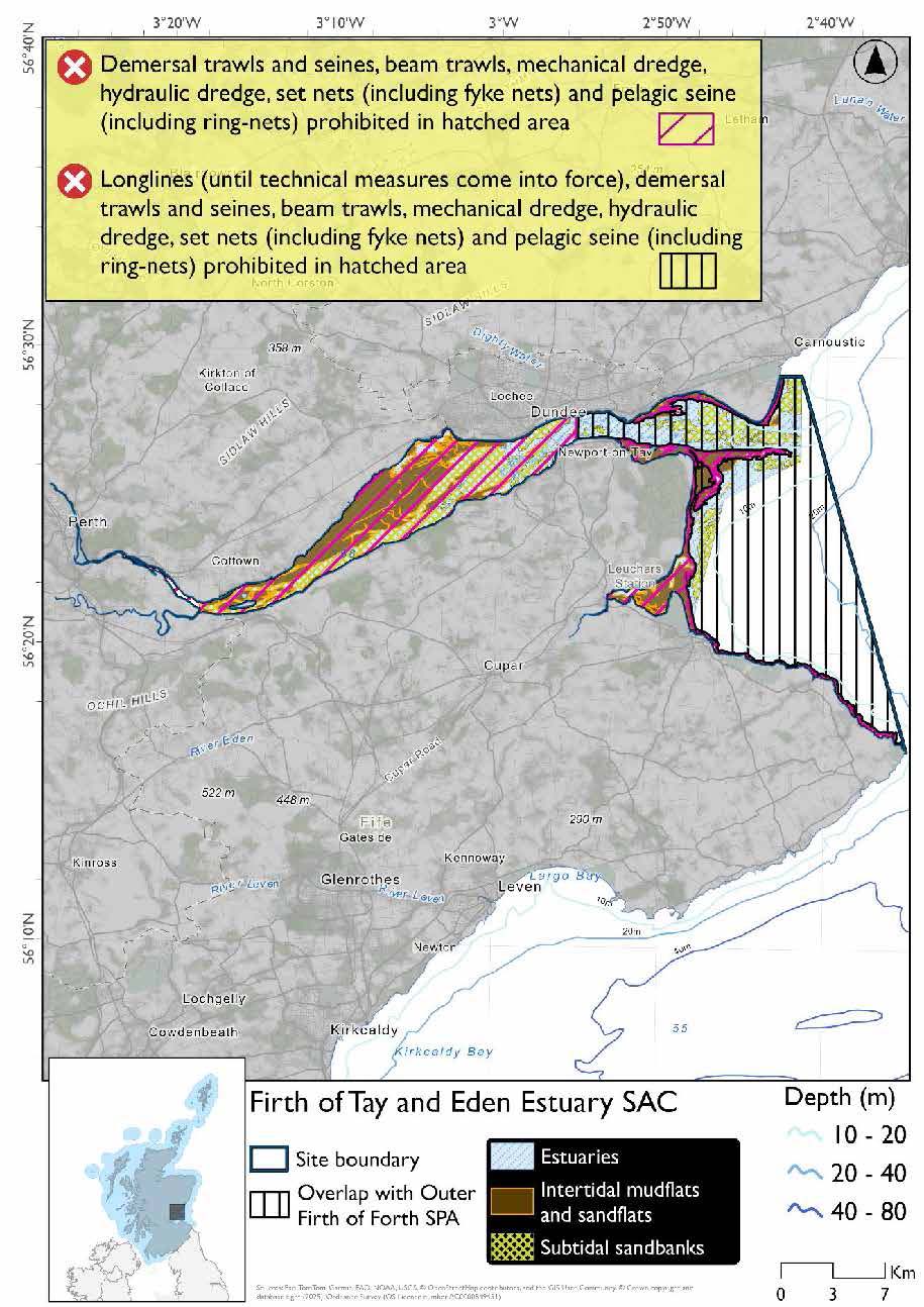
A full site level of protection from the specified gear has been identified as the only suitable option in enabling the achievement of the desired level of protection for the feature in question.
Overlapping site included in this consultation
This SAC overlaps with the Outer Firth of Forth and St Andrews Bay Complex SPA.
Rationale for measures developed
The basis for the proposed fisheries management measures for each site has been determined by the management advice for fishing activities provided by NatureScot, which can be found on their website or Sitelink as signposted throughout this document. The Fisheries Assessment for each site assesses the impacts from existing fishing activities on the protected features using the tests from the legislation relevant for the type of MPA being considered. The assessment outlines how the proposed measures address any impacts identified that could hinder the conservation objectives of the MPA.
9.1.7 Other fisheries management measures currently applying to this site
There are already management measures in place. An effort has been made to identify existing measures which affect each individual site or area, however the list may not be exhaustive. These measures are outlined below, and the proposals for further management being consulted on now are in addition to these existing measures:
- Fishing for sea fish with mobile or active gear is currently prohibited in part of the site
- Fishing for sandeel is prohibited within the Scottish zone, which is defined as the sea adjacent to Scotland up to the 200 nautical miles limit
Other conservation measures can be found in section 7 of the CMA
9.2 Isle of May SAC
9.2.1 Description and background
The Isle of May lies at the entrance to the Firth of Forth on the east coast of Scotland. The island supports a breeding colony of grey seals. The site is the largest east coast breeding colony of grey seals in Scotland and the fourth-largest breeding colony in the UK, contributing approximately 4.5% of annual UK pup production.
The rocky reefs of the Isle of May support a variety of natural resources. The fish and shellfish (including juveniles), and seaweeds living within the reef habitat.
Further information, including Conservation and Management Advice (CMA) can be found on Sitelink .
Further information on MPAs, the wider network and protected areas management is available at Scottish Government MPA policy page.
9.2.2 Protected features
The Isle of May SAC has been designated to protect:
- Grey seal; and
- Reef
9.2.3 Conservation Objectives
The reef habitat and grey seals are in favourable condition at Isle of May SAC and therefore the Conservation Objectives seek to maintain this condition.
Additional details, including the Conservation Objectives are provided in the Conservation and Management Advice document produced for this SAC and can be found on Sitelink .
9.2.4 Pressure from fishing activity
Rocky reef habitats are sensitive to physical disturbance, smothering, and siltation from bottom-contact fishing gear such as dredging and trawling. These pressures can detach sessile organisms and block water flow, affecting oxygen and nutrient exchange critical for filter feeders. While recovery is possible if pressures are removed, it depends on the scale of disturbance and local environmental conditions.
Grey seals are sensitive to disturbance from vessels and fishing activity. They are particularly sensitive during the breeding (September and late-November in Scotland, August to mid-December across the UK) and moulting (December to April periods) when they spend more time hauled out than usual. Disturbance can lead to stampedes, interrupt lactation, and cause mother-pup separation. Seals are also sensitive to underwater noise and entanglement in fishing gear.
Additional details are provided in the Conservation and Management Advice document produced for this SAC (section 6) and can be found on Sitelink.
Other resources include:
- The Feature Activity Sensitivity Tool (FeAST) which allows users to investigate the sensitivity of marine features (habitats, species, geology and landforms) in Scotland's seas, to pressures arising from human activities;
- Fisheries Guidance Notes which provide summaries of evidence on the interaction between fishing gears and specific habitats and species.
9.2.5 Fisheries management advice relevant to proposed fisheries management measures
NatureScot provides risk-based advice to help manage activities that may impact protected features and their Conservation Objectives. See section 2.3 for more detail. The CMA document also sets out the full fisheries management advice that has been summarised below for the management measures proposed:
Demersal mobile gear
Advice is to remove or avoid pressures on reefs
Hydraulic (diver or vessel)
Advice is to remove or avoid pressures for reefs
Netting (Bottom-set gill nets including tangle and trammel nets. Drift nets, purse seine, ring-nets and fyke nets.)
Reduce or limit pressures (entanglement) associated with the use of nets is recommended for seals
9.2.6 Proposed fisheries management measures
The proposed management measure for the Isle of May SAC is as follows:
Single Proposed Management Option
- Full site closure to demersal trawls and seines, beam trawl, set nets (including fyke nets), pelagic seines (including ring nets), mechanical dredge and hydraulic dredge
- Longlines (until technical measures come into force) prohibited in overlapping areas with the Outer Firth of Forth and St Andrews Bay Complex SPA which covers the whole site
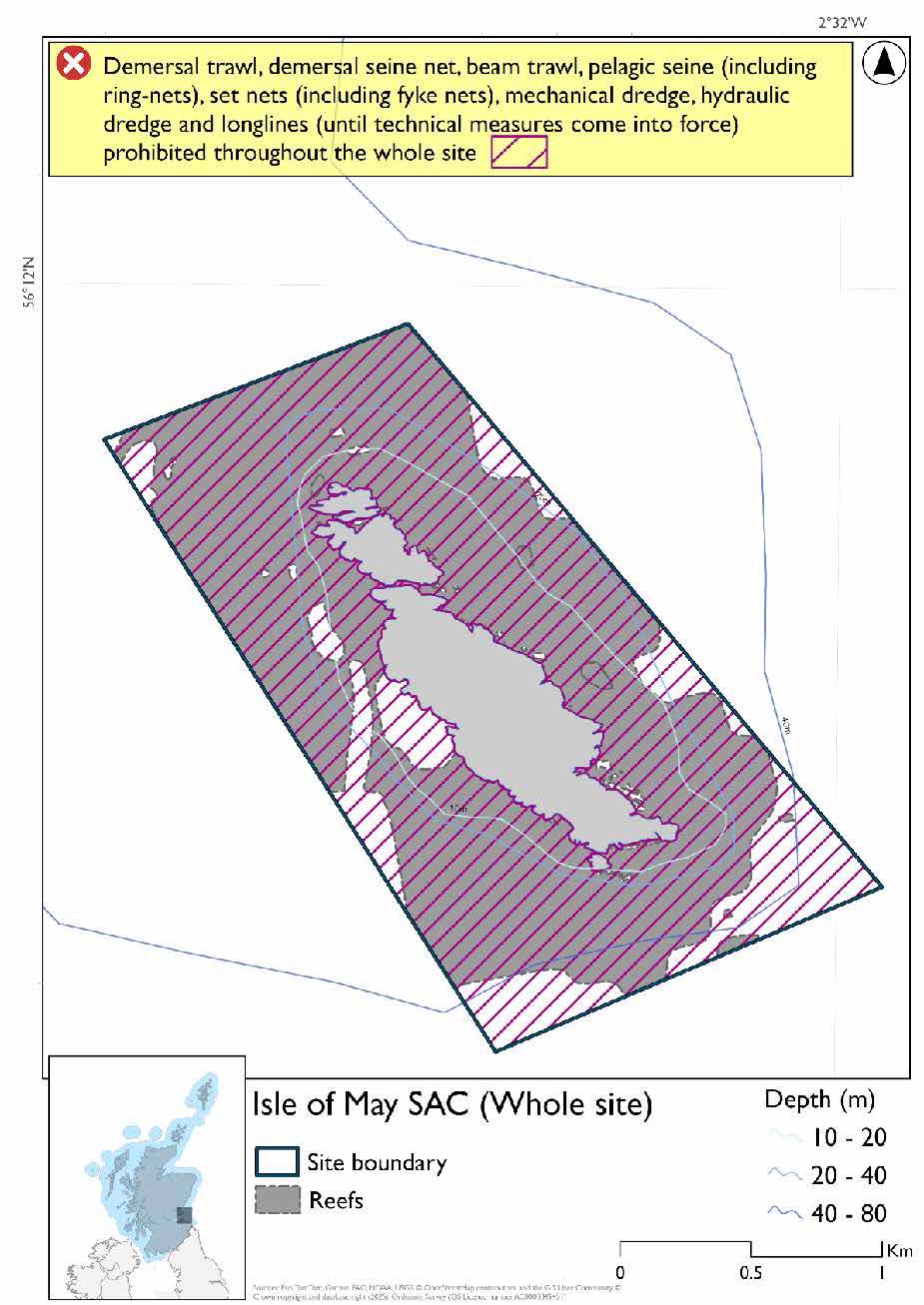
A full site level of protection from the specified gear has been identified as the only suitable option in enabling the achievement of the desired level of protection for the feature in question.
Overlapping sites included in this consultation
This SAC overlaps with the Outer Firth of Forth and St Andrews Bay Complex SPA and Forth Islands SPA.
Rationale for measures developed
The basis for the proposed fisheries management measures for each site has been determined by the management advice for fishing activities provided by NatureScot, which can be found on their website or Sitelink as signposted throughout this document. The Fisheries Assessment for each site assesses the impacts from existing fishing activities on the protected features using the tests from the legislation relevant for the type of MPA being considered. The assessment outlines how the proposed measures address any impacts identified that could hinder the conservation objectives of the MPA.
9.2.7 Other fisheries management measures currently applying to this site
There are already management measures in place. An effort has been made to identify existing measures which affect each individual site or area, however the list may not be exhaustive. These measures are outlined below, and the proposals for further management being consulted on now are in addition to these existing measures:
- Fishing for sandeel is prohibited within the Scottish zone, which is defined as the sea adjacent to Scotland up to the 200 nautical miles limit
- There is a voluntary creel fishing arrangement in place. Local boats keep their creels away from the near shore area during the seabird breeding season.
- Fishing for any species of sea fish (except herring, mackerel and sprats) from a fishing boat with an overall length not greater than 16.77 metres in part of the site
- Restriction does not apply to fishing for Mackerel; Sprats or Herring (subject to EC 1998 No. 850 art 21(1c))
Other conservation measures can be found in section 7 of the CMA.
9.3 Berwickshire and North Northumberland Coast SAC
9.3.1 Description and background
The Scottish portion of Berwickshire and North Northumberland Coast SAC covers an area of rocky coast starting east of Dunglass and extending to the border with England.
The SAC encompasses a wide variety of coastal and marine environments, including rocky shores, sediment-dominated bays, reefs, mudflats and sandflats, large shallow inlets and bays, and submerged or partially submerged sea caves.
Key bays such as Budle Bay, Beadnell Bay, and Embleton Bay are integral to the SAC, providing habitat variety that supports a rich diversity of marine life.
The SAC is one of the most varied coastlines in the UK, stretching from Alnmouth to north of St Abbs head, spanning both Scottish and English waters. Management measures are only being proposed for the Scottish section of the SAC.
Further information, including Conservation and Management Advice (CMA) can be found on Sitelink.
Further information on MPAs, the wider network and protected areas management is available at Scottish Government MPA policy page.
9.3.2 Protected features
The Berwickshire and North Northumberland Coast SAC has been designated for:
- Grey seal;
- Intertidal mudflats and sandflats;
- Large shallow inlets and bays;
- Reef; and
- Sea caves
Sea caves are not discussed further as they are not a protected feature for which fisheries management measures are required. Of the other features for which this site is designated, only reefs and grey seal are present in the area of the site under Scottish jurisdiction, and as such these are the only protected features considered.
Of the other features for which this site is designated, only reefs and grey seal are present in the area of the site under Scottish jurisdiction, and as such these are the only protected features considered.
9.3.3 Conservation Objectives
All of the biodiversity features are currently in favourable condition in the SAC. The Conservation Objectives for these features is therefore to ‘maintain’.
Additional details, including the Conservation Objectives are provided in the Conservation Advice page produced for this SAC. Advice for this site has been produced on a whole site basis, applying to both the Scottish and English areas, and has been produced by Natural England.
9.3.4 Pressure from fishing activity
Grey seals are sensitive to entanglement in fishing gear, particularly static nets and creel lines, which can cause injury or mortality. They are also sensitive to disturbance from vessels, especially near haul-out and breeding sites, and to underwater noise from fishing operations, which may disrupt resting, moulting, and pup-rearing behaviours. Prolonged or novel disturbances can lead to site abandonment and reduced pup survival.
Reefs are sensitive to physical disturbance from bottom-contact fishing gear such as dredging and trawling. These activities can damage benthic habitats, alter sediment structure, reduce habitat complexity, and impact associated species. Reefs are particularly sensitive to smothering and siltation, which can block water flow and affect filter feeders. Recovery varies depending on the intensity and frequency of disturbance and local environmental conditions.
Additional details are provided in the advice for this site which can be accessed on Sitelink.
Other resources include:
- The Feature Activity Sensitivity Tool (FeAST) which allows users to investigate the sensitivity of marine features (habitats, species, geology and landforms) in Scotland's seas, to pressures arising from human activities;
- Fisheries Guidance Notes which provide summaries of evidence on the interaction between fishing gears and specific habitats and species.
9.3.5 Fisheries management advice relevant to proposed fisheries management measures
NatureScot provides risk-based advice to help manage activities that may impact protected features and their Conservation Objectives. See section 2.3 for more detail. The Conservation Advice page produced for this SAC also sets out the full fisheries management advice that has been summarised below for the management measures proposed:
Demersal mobile/active gear
Advice is to avoid or remove pressures imposed on the stony reef and bedrock reef features. Exclusion of demersal mobile gears such as demersal trawls and seines, hydraulic dredges, and mechanical dredges is therefore recommended.
Hydraulic (diver or vessel)
Reduce or limit pressure from all hydraulic methods (e.g. diver or vessel) is recommended for shallow inlets and bays, remove or avoid for reef.
Netting (Bottom-set gill nets including tangle and trammel nets. Drift nets, purse seine, ring-nets and fyke nets.)
Reduce or limit pressures - (entanglement) associated with the use of nets is recommended for seals.
Fisheries management advice is found in the in the Conservation Advice page produced for this SAC.
9.3.6 Proposed fisheries management measures
The proposed management measures for the Scottish portion of Berwickshire and North Northumberland coast SAC are as follows:
Option 1
- Demersal trawls and seines, beam trawl, hydraulic dredge and mechanical dredge prohibited in part of the site
- Full site closure to set nets (including fyke nets) and pelagic seine (including ring-nets)
- Longlines (until technical measures come into force) prohibited in overlapping areas with the Outer Firth of Forth and St Andrews Bay Complex SPA
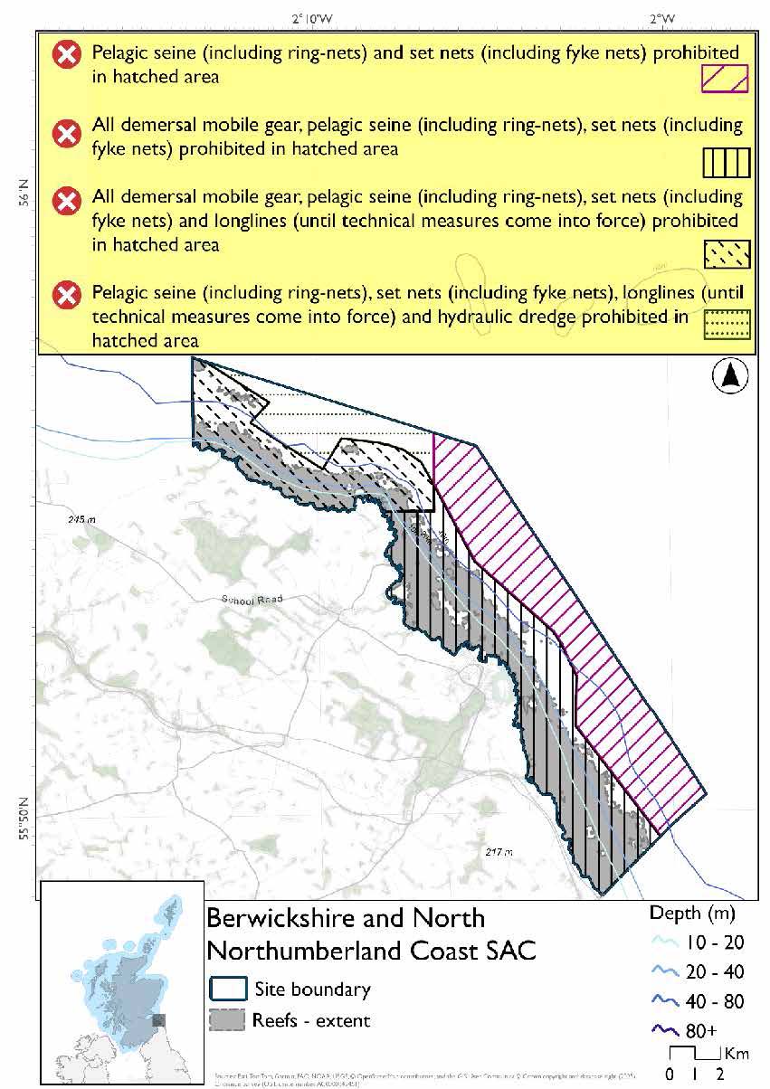
Option 2*
- Full site closure to demersal trawls and seines, beam trawl, mechanical dredge, hydraulic dredge, set nets (including fyke nets) and pelagic seine (including ring-nets)
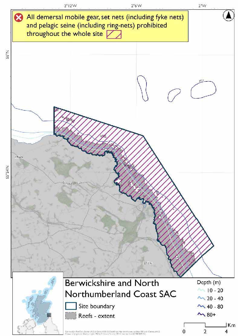
*The measures for Option 2 proposals only come from gear types prohibited in non-overlapping areas. Overlapping restrictions may still apply from overlapping sites or areas dependent on the decisions taken for that site or area.
Overlapping sites included in this consultation
This SAC overlaps with the Outer Firth of Forth and St Andrews Bay Complex SPA and St Abb’s Head to Fast Castle SPA.
Rationale for measures development
The basis for the proposed fisheries management measures for each site has been determined by the management advice for fishing activities provided by NatureScot, which can be found on their website or Sitelink as signposted throughout this document. The Fisheries Assessment for each site assesses the impacts from existing fishing activities on the protected features using the tests from the legislation relevant for the type of MPA being considered. The assessment outlines how the proposed measures address any impacts identified that could hinder the conservation objectives of the MPA.
9.3.7 Other fisheries management measures currently applying to this site
There are already management measures in place. An effort has been made to identify existing measures which affect each individual site or area, however the list may not be exhaustive. These measures are outlined below, and the proposals for further management being consulted on now are in addition to these existing measures:
- Fishing for sandeel is prohibited within the Scottish zone, which is defined as the sea adjacent to Scotland up to the 200 nautical miles limit
- Demersal dredge and trawl prohibited within part of the site
9.4 Outer Firth of Forth and St Andrews Bay Complex SPA
9.4.1 Description and background
The Outer Firth of Forth and St Andrews Bay Complex SPA is a large estuarine/marine site on south-east coast of Scotland consisting of the two closely adjacent Firths of Forth and Tay. The SPA includes a diverse range of sheltered firths, inlets, sandy bays, and offshore marine habitats. These areas are vital for seabirds and waterbirds to feed, moult, rest, and roost, and lie in close proximity to major breeding colonies on nearby islands and coastal cliffs. The site is particularly important during the breeding season for species such as gannet, kittiwake, puffin, and common tern, the latter of which forms the largest breeding concentration in Scotland within this SPA.
In winter, the SPA becomes a critical refuge for migratory species that travel from as far as northern Europe and western Siberia. It supports over 35% of the British wintering population of eider and more than 23% of the velvet scoter population. It also holds the largest Scottish concentrations of red-throated diver and little gull during the non-breeding season.
Further information, including Conservation and Management Advice (CMA) can be found on Sitelink .
As this SPA overlaps into the offshore region there is more detailed additional information JNCCs website.
Further information on MPAs, the wider network and protected areas management is available at Scottish Government MPA policy page.
9.4.2 Protected features
The Outer Firth of Forth and St Andrews Bay Complex SPA has been designated for a large range of seabird species. These include:
- Arctic tern;
- Black-headed gull;
- Common gull;
- Common scoter;
- Common tern;
- Eider;
- Gannet;
- Goldeneye;
- Guillemot;
- Herring gull;
- Kittiwake;
- Little gull;
- Long-tailed duck;
- Manx shearwater;
- Puffin;
- Razorbill;
- Red-breasted merganser;
- Red-throated diver;
- Shag;
- Slavonian grebe; and
- Velvet scoter
The protected features of the Outer Firth of Forth and St Andrews Bay Complex SPA are protected within the SPA throughout the year, irrespective of the season for which they qualified as a protected feature.
9.4.3 Conservation Objectives
Waterfowl, non-breeding razorbill and wintering gull protected features have not been assessed since designation, however corroborative evidence suggests there is no reason to suspect deterioration in condition since designation. Therefore, for red-throated diver, Slavonian grebe, eider, long-tailed duck, common scoter, velvet scoter, goldeneye, red-breasted merganser, razorbill, little gull, black-headed gull, common gull, and herring gull, the Conservation Objectives seek to maintain this condition.
Arctic tern, gannet, guillemot and puffin are in favourable condition at all associated SPA breeding colonies. Therefore, the Conservation Objectives for these protected features seek to maintain this condition.
For Manx shearwater, the origin of the birds in the Outer Firth of Forth and St Andrews Bay Complex SPA is not known. The population is thought to be a mixture of breeding birds, immature birds, failed breeders and sabbaticals. There is no reason to suspect deterioration in condition since designation, therefore the Conservation Objectives seek to maintain this condition.
Breeding common tern, shag, kittiwake and herring gull are in unfavourable condition at one or more associated SPA breeding colonies. For these species, the Conservation Objectives seek to restore favourable condition.
Additional details, including the Conservation Objectives are provided in the Conservation and Management Advice document produced for this SPA and can be found on Sitelink .
9.4.3 Pressure from fishing activity
All of the protected species in the SPA are sensitive to pressures from fishing activity. All of the protected species are susceptible to entanglement and accidental bycatch. In particular, shag and gannet are considered two of the species most at risk from accidental bycatch in UK waters. Among other species the level of sensitivity to entanglement and bycatch varies.
A number of other pressures associated with fishing also impact the protected species. Many of the species are sensitive to changes in the availability of prey species, particularly sandeel. Changes to water quality, clarity, or turbidity can also impact many of the protected species. Some species are also sensitive to disturbance and displacement from vessel movement.
Additional details are provided in the Conservation and Management Advice document produced for this SPA (section 6) and can be found on Sitelink.
Other resources include:
- The Feature Activity Sensitivity Tool (FeAST) which allows users to investigate the sensitivity of marine features (habitats, species, geology and landforms) in Scotland's seas, to pressures arising from human activities;
- Fisheries Guidance Notes which provide summaries of evidence on the interaction between fishing gears and specific habitats and species.
9.4.4 Fisheries management advice relevant to proposed fisheries management measures
NatureScot provides risk-based advice to help manage activities that may impact protected features and their Conservation Objectives. See section 2.3 for more detail. The CMA document also sets out the full fisheries management advice that has been summarised below for the management measures proposed:
Hydraulic gear
Advice is to remove or avoid pressures (removal of prey species and disturbance of prey-supporting habitat) associated with hydraulic fishing that has the potential to damage seabed habitat (in particular, sandeel habitat).
Static gear (drift nets and bottom set nets inc. fyke nets)
Advice is to remove or avoid pressures (entanglement) associated with the use of all static nets. Spatial exclusion of static nets in areas identified as being important for seaducks, red-throated diver, Slavonian grebe and red-breasted merganser (as identified from habitat and dive depth preferences) is recommended.
Pelagic gear
Pelagic fishing for herring/sprat may occur within or around the SPA. A principle objective of the management of the fishery should be ensuring that the fishing activity does not prevent or disrupt the availability of prey species for red-throated diver, Slavonian grebe, red-breasted merganser. As such it should be considered as part of a broader ecosystem based approach to management of this fishery.
Longlining (not including jigging)
Long-lining (pelagic and demersal) may occur within or around the SPA(s). Current understanding is that long-line fisheries are largely restricted to offshore waters. Site-specific measures for long-lining are not currently considered appropriate due to the scale of the fishery, and the wide-spread interaction with seabirds. However, there is evidence of seabird bycatch in long-line (not jigging) fisheries therefore it is recommended this requires wider seas management measures.
For the SPAs advice has also been provided on maximum dive depth and seasonality for protected features of each site and can be found in the Fishing Activity Further Advice and Evidence document. Supplementary advice can also be found on NatureScot’s website.
9.4.5 Proposed fisheries management measures
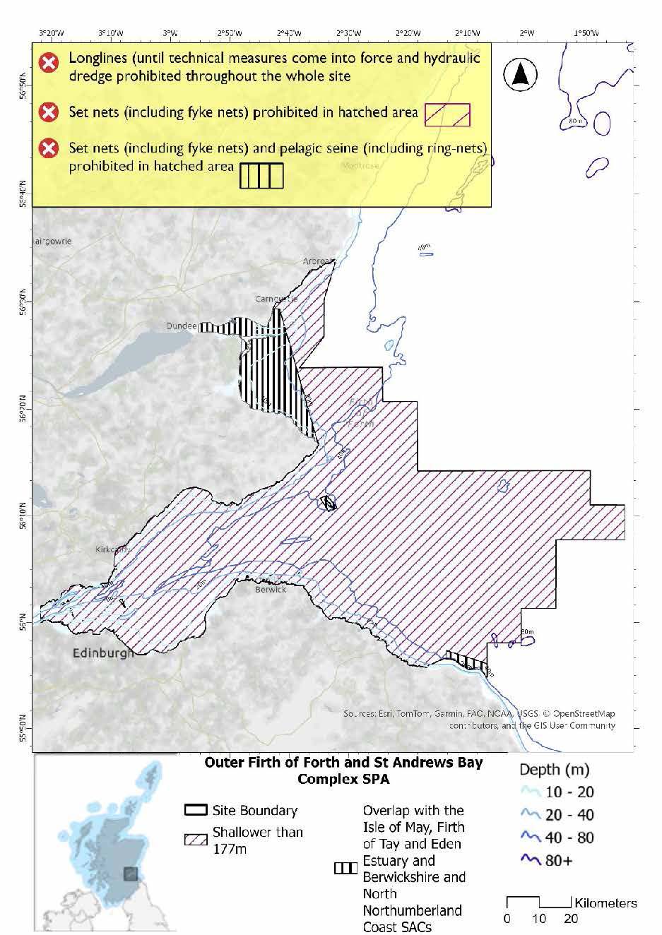
The proposed management measure for the Outer Firth of Forth and St Andrews Bay complex SPA is as follows:
Single Proposed Management Option*
- Full site closure to longlines (until technical measures come into force) and hydraulic dredge
- Set nets (including fyke nets) prohibited in areas down to 177m based on presence and maximum dive depth for guillemot which covers the whole site.
- Pelagic seine (including ring-nets) prohibited in overlapping areas with the Firth of Tay and Eden Estuary, Isle of May and Berwickshire and North Northumberland Coast SACs
A full site level of protection from the specified gear has been identified as the only suitable option in enabling the achievement of the desired level of protection for the feature in question.
*This site will have other demersal mobile measures that may apply from the overlapping portions with other sites. The Firth of Tay and Eden Estuary, Isle of May and Berwickshire and North Northumberland Coast SACs would prohibit demersal trawls and seines, beam trawls and mechanical dredge in the overlapping areas shown on the map above.
Overlapping sites included in this consultation
This SPA overlaps with the Forth islands SPA and St Abb’s Head to Fast Castle SPA and Firth of Tay and Eden Estuary SAC, Isle of May SAC and Berwickshire and North Northumberland Coast SAC.
Rationale for developed measures
The basis for the proposed fisheries management measures for each site has been determined by the management advice for fishing activities provided by NatureScot, which can be found on their website or Sitelink as signposted throughout this document. The Fisheries Assessment for each site assesses the impacts from existing fishing activities on the protected features using the tests from the legislation relevant for the type of MPA being considered. The assessment outlines how the proposed measures address any impacts identified that could hinder the conservation objectives of the MPA.
9.4.6 Other fisheries management measures currently applying to this site
There are already management measures in place. An effort has been made to identify existing measures which affect each individual site or area, however the list may not be exhaustive. These measures are outlined below, and the proposals for further management being consulted on now are in addition to these existing measures:
- Fishing for sandeel is prohibited within the Scottish zone, which is defined as the sea adjacent to Scotland up to the 200 nautical miles limit
- Fishing for any species of sea fish (except herring, mackerel and sprats) from a fishing boat with an overall length not greater than 16.77 metres in part of the site.
- Restriction does not apply to fishing for Mackerel; Sprats or Herring (subject to EC 1998 No. 850 art 21(1c))
- St Andrews Bay - Fishing for sea fish with mobile or active gear prohibited in part of the site
- Fishing with any towed gear with a codend mesh size of less than 32nmm or static nets less than 30 is prohibited in part of the site between 01 Oct and 31 March
- Arbroath - Fishing for sea fish with mobile or active gear prohibited in part of the site
- St Abbs - Fishing for sea fish with mobile or active gear prohibited in part of the site
- Within the Isle of May SAC there is a voluntary creel fishing arrangement in place. Local boats keep their creels away from the near shore area during the seabird breeding season.
Other conservation measures can be found in section 7 of the CMA.
9.5 Forth Islands SPA
9.5.1 Description and background
Forth Islands SPA consists of a series of islands supporting the main seabird colonies in the Firth of Forth. The islands of Inchmickery, Isle of May, Fidra, The Lamb, Craigleith and Bass Rock were classified on 25 April 1990. The extension to the site, classified on the 16 February 2004 consists of the island of Long Craig, which, at the time of classification, supported the largest colony of roseate tern in Scotland. It is the most northerly of only six regular British colonies.
These islands rise prominently from the surrounding waters and are characterized by steep cliffs, rocky shorelines, and vegetated plateaus that provide exceptional nesting and roosting habitats for seabirds. The SPA also includes a surrounding marine extension of approximately 2 km from each island, covering the seabed, water column, and surface waters essential for foraging activities during the breeding season.
Further information, including Conservation and Management Advice (CMA) can be found on Sitelink.
Further information on MPAs, the wider network and protected areas management is available at Scottish Government MPA policy page.
9.5.2 Protected features
The Forth Islands SPA has been designated to protect 13 species of breeding seabirds, a breeding seabird assemblage, and their supporting habitats. These species are:
- Arctic tern;
- Common tern;
- Cormorant;
- Gannet;
- Guillemot;
- Herring gull;
- Kittiwake;
- Lesser black-backed gull;
- Puffin;
- Razorbill;
- Roseate tern;
- Sandwich tern; and
- Shag
The protected features of the Forth Islands SPA are protected within the SPA throughout the year, irrespective of the season for which they qualified as a protected feature.
9.5.3 Conservation Objectives
The following protected features are in favourable condition at the Forth Islands SPA: Arctic tern, guillemot, herring gull, gannet, lesser black-backed gull, puffin and razorbill. Therefore, the Conservation Objectives seek to maintain this condition.
The following protected features are in unfavourable condition at the Forth Islands SPA: common tern, cormorant, kittiwake, roseate tern, shag and sandwich tern. Therefore, the Conservation Objectives seek to restore this condition.
Additional details, including the Conservation Objectives are provided in the Conservation and Management Advice document produced for this SPA and can be found on Sitelink.
9.5.4 Pressure from fishing activity
Fishing activity exerts two primary pressures on protected seabird species: bycatch and prey depletion. Bycatch affects a wide range of species including terns, kittiwakes, auks (puffins, guillemots, razorbills), shags, gulls, cormorants, and gannets. These birds are sensitive to entanglement in surface, pelagic, and longline fishing gears, with some species, like shags and gannets, among the most sensitive. Discarded fishing gear also poses a risk of entanglement, particularly for gannets and cormorants.
Prey depletion due to overfishing impacts all listed species, especially those reliant on forage fish like sandeels. Reduced food availability can lead to lower breeding success and survival rates. Additionally, increased water turbidity from fishing operations may hinder foraging efficiency for diving species such as terns, auks, and gannets, which depend on clear waters to locate prey. These pressures collectively threaten the health and sustainability of seabird populations in protected areas.
Additional details are provided in the Conservation and Management Advice document produced for this SPA (section 6) and can be found on Sitelink.
Other resources include:
- The Feature Activity Sensitivity Tool (FeAST) which allows users to investigate the sensitivity of marine features (habitats, species, geology and landforms) in Scotland's seas, to pressures arising from human activities;
- Fisheries Guidance Notes which provide summaries of evidence on the interaction between fishing gears and specific habitats and species.
9.5.5 Fisheries management advice relevant to proposed fisheries management measures
NatureScot provides risk-based advice to help manage activities that may impact protected features and their Conservation Objectives. See section 2.3 for more detail. The CMA document also sets out the full fisheries management advice that has been summarised below for the management measures proposed:
Hydraulic gear
Removal or avoidance of pressures (removal of prey species and disturbance of prey-supporting habitat) associated with hydraulic fishing that has the potential to damage seabed habitat (in particular, sandeel habitat, herring spawning grounds) is recommended.
Static gear (drift nets and bottom set nets inc. fyke nets)
Advice is to remove or avoid pressures (entanglement) associated with the use of all static nets. Spatial exclusion of all static nets in areas identified as being important for kittiwake, guillemot, razorbill, gannet, shag, and cormorant (as identified from habitat and dive depth preferences) is recommended.
Pelagic gear
Pelagic fishing for herring/sprat may occur within or around the SPA. It is recommended that a principal objective of the management of the fishery should be ensuring that the fishing activity does not prevent or disrupt the availability of prey species i.e. it should be considered as part of a broader ecosystem-based approach to management of this fishery.
Longlining (not including jigging)
Long-lining (pelagic and demersal) may occur within or around the SPA(s). Current understanding is that long-line fisheries are largely restricted to offshore waters. Site-specific measures for long-lining are not currently considered appropriate due to the scale of the fishery, and the wide-spread interaction with seabirds. However, there is evidence of seabird bycatch in long-line (not jigging) fisheries therefore it is recommended this requires wider seas management measures.
For the SPAs advice has also been provided on maximum dive depth and seasonality for protected features of each site and can be found in the Fishing Activity Further Advice and Evidence document. Supplementary advice can also be found on NatureScot’s website.
9.5.6 Proposed fisheries management measures
NatureScot also provided amalgamated season advice for this site but individual seasonality for species has been used to develop consultation options.
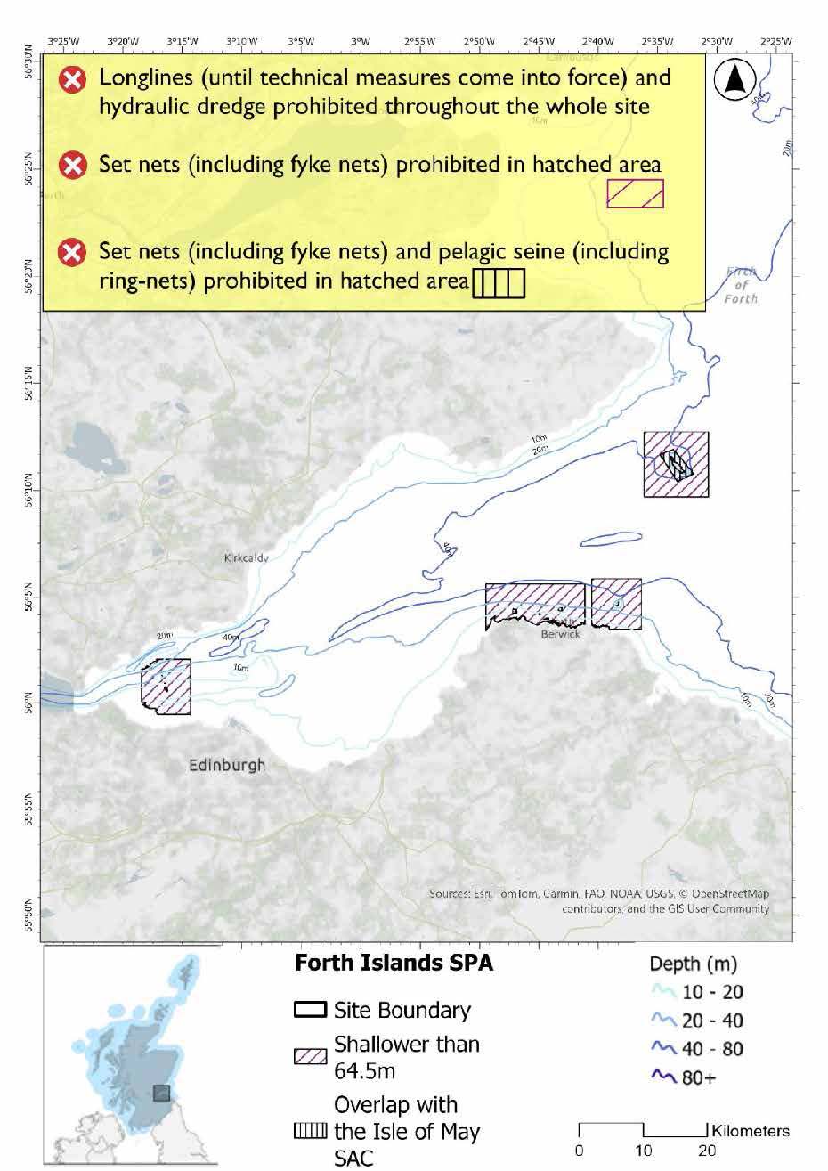
The proposed management measure for the Forth Islands SPA is follows:
Single Proposed Management Option*
- Full site closure to longlines (until technical measures come into force) and hydraulic dredge.
- Set nets (including fyke nets) prohibited in areas down to 64.5m based on presence and maximum dive depth for shag. The whole site is shallower than 64.5m and shag present all year so doesn’t need to follow advice for guillemot with max dive depth of 177m
- Pelagic seine (including ring-nets) prohibited in overlapping area with the Isle of May a SAC
A full site level of protection from the specified gear has been identified as the only suitable option in enabling the achievement of the desired level of protection for the feature in question.
*This site will have other demersal mobile measures that may apply from the overlapping portions with other sites. The Isle of May SAC would prohibit demersal trawls and seines, beam trawls and mechanical dredge in the overlapping area shown on the map above.
Overlapping sites included in this consultation
This SPA overlaps with the Outer Firth of Forth and St Andrews Bay Complex SPA and the Isle of May SAC.
Rationale for developed measures
The basis for the proposed fisheries management measures for each site has been determined by the management advice for fishing activities provided by NatureScot, which can be found on their website or Sitelink as signposted throughout this document. The Fisheries Assessment for each site assesses the impacts from existing fishing activities on the protected features using the tests from the legislation relevant for the type of MPA being considered. The assessment outlines how the proposed measures address any impacts identified that could hinder the conservation objectives of the MPA.
9.5.7 Other fisheries management measures currently applying to this site
There are already management measures in place. An effort has been made to identify existing measures which affect each individual site or area, however the list may not be exhaustive. These measures are outlined below, and the proposals for further management being consulted on now are in addition to these existing measures:
- Fishing for sandeel is prohibited within the Scottish zone, which is defined as the sea adjacent to Scotland up to the 200 nautical miles limit
- Fishing for any species of sea fish (except herring, mackerel and sprats) from a fishing boat with an overall length not greater than 16.77 metres in part of the site
- Restriction does not apply to fishing for Mackerel; Sprats or Herring (subject to EC 1998 No. 850 art 21(1c))
- Fishing with any towed gear with a codend mesh size of less than 32mm or static nets less than 30 is prohibited in part of the site between 01 Oct and 31 March
Other conservation measures can be found in section 7 of the CMA.
9.6 St Abb’s Head to Fast Castle SPA
9.6.1 Description and background
St Abb's Head to Fast Castle SPA comprises an area of sea cliffs and coastal strip stretching over 10km along the Berwickshire Coast north of St Abbs. These cliffs rise to heights of up to 94m and provide extensive nesting habitat for seabirds. The SPA overlaps with that of St Abb’s Head to Fast Castle SSSI and includes a marine extension of approximately 1 km offshore. The marine extension covers the seabed, water column, and surface waters that are critical for foraging during the breeding season.
Further information, including Conservation and Management Advice (CMA) can be found on Sitelink.
Further information on MPAs, the wider network and protected areas management is available at Scottish Government MPA policy page.
9.6.2 Protected features
The St Abb’s Head to Fast Castle SPA has been designated to protect:
- Guillemot;
- Herring gull;
- Kittiwake;
- Razorbill; and
- Shag
The protected features of the St Abb’s Head to Fast Castle SPA are protected within the SPA throughout the year, irrespective of the season for which they qualified as a protected feature.
9.6.3 Conservation Objectives
The following protected features are in favourable condition at St Abb’s Head to Fast Castle SPA: guillemot and razorbill. Therefore, the Conservation Objectives seek to maintain this condition.
The following protected features are in unfavourable condition at St Abb’s Head to Fast Castle SPA: kittiwake, herring gull and shag. Therefore, the Conservation Objectives seek to restore this condition.
Additional details, including the Conservation Objectives are provided in the Conservation and Management Advice document produced for this SPA and can be found on Sitelink.
9.6.4 Pressure from fishing activity
Kittiwakes, guillemots, razorbills, shags, and herring gulls are all sensitive to accidental bycatch in fishing nets, particularly surface gears. shags are especially sensitive, with susceptibility extending to pelagic and demersal gear types. These species also face risks from prey depletion due to climate change and industrial fishing, which can reduce breeding success and survival. Foraging efficiency may be further impaired by increased water turbidity, particularly for diving species like guillemots, razorbills, and shags.
Displacement due to vessel activity can disrupt breeding and foraging behaviour, with guillemots and razorbills also showing sensitivity to visual and noise disturbance from vessel traffic.
Additional details are provided in the Conservation and Management Advice document produced for this SPA (section 6) and can be found on Sitelink.
Other resources include:
- The Feature Activity Sensitivity Tool (FeAST) which allows users to investigate the sensitivity of marine features (habitats, species, geology and landforms) in Scotland's seas, to pressures arising from human activities;
- Fisheries Guidance Notes which provide summaries of evidence on the interaction between fishing gears and specific habitats and species.
9.6.5 Fisheries management advice relevant to proposed fisheries management measures
NatureScot provides risk-based advice to help manage activities that may impact protected features and their Conservation Objectives. See section 2.3 for more detail. The CMA document also sets out the full fisheries management advice that has been summarised below for the management measures proposed:
Hydraulic gear
Removal or avoidance of pressures (removal of prey species and disturbance of prey-supporting habitat) associated with hydraulic fishing that has the potential to damage seabed habitat (in particular, sandeel habitat, herring spawning grounds) is recommended.
Static gear (drift nets and bottom set nets inc. fyke nets)
Advice is to remove or avoid pressures (entanglement) associated with the use of all static nets. Spatial exclusion of all static nets in areas identified as being important for kittiwake, guillemot, razorbill, and shag (as identified from habitat and dive depth preferences) is recommended.
Pelagic gear
Pelagic fishing for herring/sprat may occur within or around the SPA. It is recommended that a principal objective of the management of the fishery should be ensuring that the fishing activity does not prevent or disrupt the availability of prey species i.e. it should be considered as part of a broader ecosystem-based approach to management of this fishery.
Longlining (not including jigging)
Long-lining (pelagic and demersal) may occur within or around the SPA(s). Current understanding is that long-line fisheries are largely restricted to offshore waters. Site-specific measures for long-lining are not currently considered appropriate due to the scale of the fishery, and the wide-spread interaction with seabirds. However, there is evidence of seabird bycatch in long-line (not jigging) fisheries therefore it is recommended this requires wider seas management measures.
For the SPAs advice has also been provided on maximum dive depth and seasonality for protected features of each site and can be found in the Fishing Activity Further Advice and Evidence document. Supplementary advice can also be found on NatureScot’s website.
9.6.6 Proposed fisheries management measures
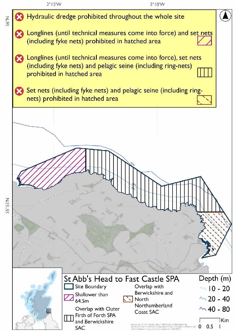
The proposed management measure for the St Abb’s Head to Fast Castle SPA is as follows:
Single Proposed Management Option*
- Set nets (including fyke nets) prohibited in areas down to 64.5m based on presence and maximum dive depth of shag. (This matches measures in overlapping area with Outer Firth of Forth and St Andrews Bay for guillemot and set net prohibition for seals in overlapping area with Berwickshire and North Northumberland Coast SAC)
- Pelagic seine (including ring-nets) prohibited in overlapping areas with the Berwickshire and North Northumberland Coast SAC
- Longlines (until technical measures come into force) prohibited in overlapping area with the Outer Firth of Forth and St Andrews Bay Complex SPA
- Full site closure to hydraulic dredge
A full site level of protection from the specified gear has been identified as the only suitable option in enabling the achievement of the desired level of protection for the feature in question.
* This site will have other demersal mobile measures that may apply from the overlapping portions with other sites. The overlapping portions shown on the map above with the Berwickshire and North Northumberland Coast SAC would prohibit demersal trawls and seines, beam trawls and mechanical dredge.
Overlapping sites included in this consultation
This SPA overlaps with the Berwickshire and North Northumberland Coast SAC and the Outer Firth of Forth and St Andrews Bay Complex SPA.
Rationale for developed measures
The basis for the proposed fisheries management measures for each site has been determined by the management advice for fishing activities provided by NatureScot, which can be found on their website or Sitelink as signposted throughout this document. The Fisheries Assessment for each site assesses the impacts from existing fishing activities on the protected features using the tests from the legislation relevant for the type of MPA being considered. The assessment outlines how the proposed measures address any impacts identified that could hinder the conservation objectives of the MPA.
9.6.7 Other fisheries management measures currently applying to this site
There are already management measures in place. An effort has been made to identify existing measures which affect each individual site or area, however the list may not be exhaustive. These measures are outlined below, and the proposals for further management being consulted on now are in addition to these existing measures:
- Fishing for sandeel is prohibited within the Scottish zone, which is defined as the sea adjacent to Scotland up to the 200 nautical miles limit
- Fishing for sea fish with mobile or active gear prohibited in part of the site.
Other conservation measures can be found in section 7 of the CMA.
Contact
Email: marine_biodiversity@gov.scot