
Fisheries Management Measures within Scottish Inshore Marine Protected Areas (MPAs) and Proposed Priority Marine Feature (PMF) Management Areas - Site and Area Proposal Document
This document describes the process, justification and evidence used to develop site and area specific fisheries management measures. It outlines key information for each site and area including their features, and risks of potential pressures.

19. Proposed PMF management areas in the Argyll marine region
19.1 Loch a' Chnuic and Ardilistry (Islay) proposed PMF management area
19.1.1 Description and background*
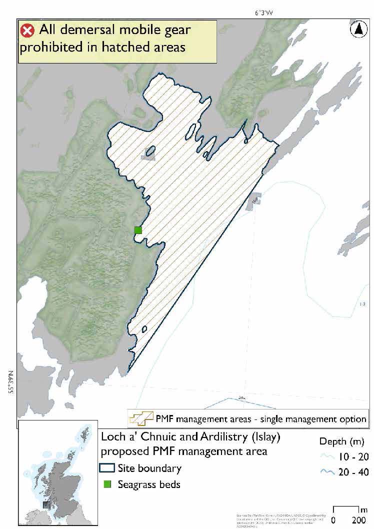
Loch a' Chnuic and Ardilistry (Islay) proposed PMF management area covers the bay area containing Loch a'Chnuic and Ardilistry Bay on the South-East coast of Islay. This area has been selected to protect:
- Seagrass beds
*This proposed PMF management area overlaps with the South-East Islay Skerries SAC.
19.1.2 Fisheries management measures proposed
PMF management areas will be closed to demersal trawls and seines, beam trawls, mechanical dredges, and hydraulic dredges. This is because the features present in these areas are sensitive to these gear types.
This PMF management area overlaps with management measures being consulted on for South-East Islay Skerries SAC for set nets (including fyke nets) and pelagic seine (including ring-nets) which are not shown in the map below.
Please check overlapping site map option(s) to see pelagic and static gear measures.
19.1.3 Options under consideration
A single management option has been developed for this PMF management area. Only one option was identified due to one of, or combination of, evidence (fishing activity or PMF related), boundary setting principles and compliance considerations.
The boundary was reduced to the bay where the seagrass bed record is located. No additional fishing data were provided within the proposed PMF management area.
19.1.4 Other fisheries management measures currently applying to this area
There are already management measures in place. An effort has been made to identify existing measures which affect each individual site or area, however the list may not be exhaustive. These measures are outlined below, and the proposals for further management being consulted on now are in addition to these existing measures:
- Fishing for sandeel is prohibited within the Scottish zone, which is defined as the sea adjacent to Scotland up to the 200 nautical miles limit
19.2 Loch a' Chumhainn (Mull) proposed PMF management area
19.2.1 Description and background*
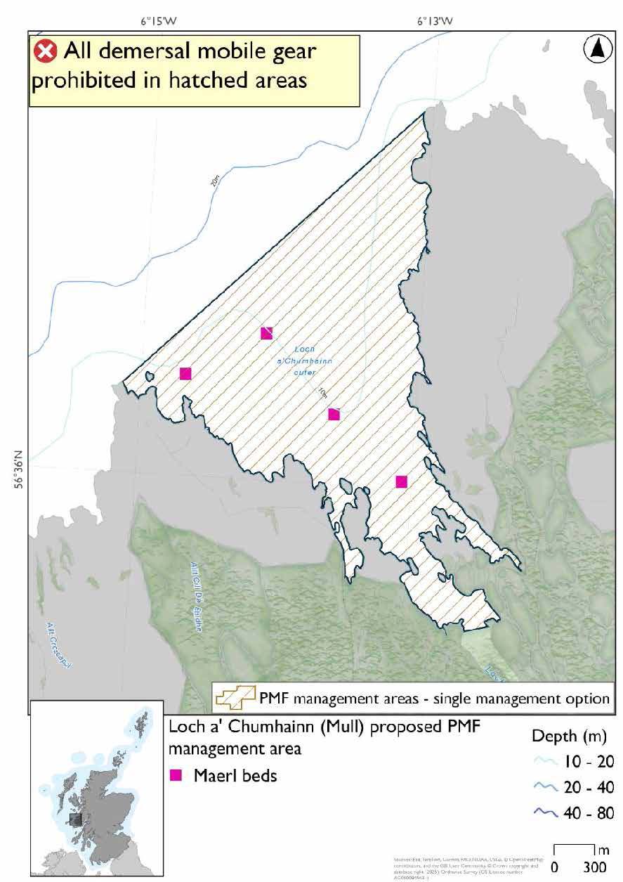
Loch a' Chumhainn (Mull) proposed PMF management area covers the lower half of Loch a' Chumhainn, from the mouth of the loch to where it significantly narrows halfway down. This area has been selected to protect:
- Maerl beds
*This proposed PMF management area overlaps with the Sea of the Hebrides NCMPA and Inner Hebrides and the Minches SAC.
19.2.2 Fisheries management measures proposed
PMF management areas will be closed to demersal trawls and seines, beam trawls, mechanical dredges, and hydraulic dredges. This is because the features present in these areas are sensitive to these gear types.
This is an area where the protection of the maerl beds contributes to the management required for the Inner Hebrides Carbonate Production Area of the Sea of the Hebrides NCMPA.
This PMF management area overlaps with management measures being consulted on for Inner Hebrides and the Minches SAC and Sea of the Hebrides NCMPA for set nets (not including fyke nets) which are not shown in the map below.
Please check one of the overlapping site map option(s) to see static gear measures. Both sets of maps show the same thing for overlapping portion.
19.2.3 Options under consideration
A single management option has been developed for this PMF management area. Only one option was identified due to one of, or combination of, evidence (fishing activity or PMF related), boundary setting principles and compliance considerations.
The boundary was extended slightly to straighten it at the mouth of the loch. No additional fishing data were provided within the proposed management area.
19.2.4 Other fisheries management measures currently applying to this area
There are already management measures in place. An effort has been made to identify existing measures which affect each individual site or area, however the list may not be exhaustive. These measures are outlined below, and the proposals for further management being consulted on now are in addition to these existing measures:
- Fishing for sandeel is prohibited within the Scottish zone, which is defined as the sea adjacent to Scotland up to the 200 nautical miles limit
19.3 Loch Craignish (Argyll) proposed PMF management area
19.3.1 Description and background*
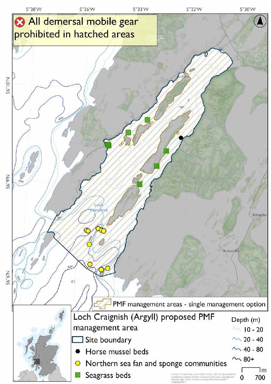
Loch Craignish (Argyll) proposed PMF management area covers the entirety of Loch Craignish in Argyll as far out as Garbh Reisa. This area has been selected to protect:
- Horse mussel beds;
- Northern sea fan and sponge communities; and
- Seagrass beds
*This proposed PMF management area overlaps with the Inner Hebrides and the Minches SAC.
19.3.2 Fisheries management measures proposed
PMF management areas will be closed to demersal trawls and seines, beam trawls, mechanical dredges, and hydraulic dredges. This is because the features present in these areas are sensitive to these gear types.
This PMF management area overlaps with management measures being consulted on for Inner Hebrides and the Minches SAC for set nets (not including fyke nets) which are not shown in the map below.
Please check overlapping site map option(s) to see static gear measures.
19.3.3 Options under consideration
A single management option has been developed for this PMF management area. Only one option was identified due to one of, or combination of, evidence (fishing activity or PMF related), boundary setting principles and compliance considerations.
The boundary was extended slightly at the mouth of the loch to encompass additional northern sea fan and sponge communities records and taking into account additional fishing data provided.
19.3.4 Other fisheries management measures currently applying to this area
There are already management measures in place. An effort has been made to identify existing measures which affect each individual site or area, however the list may not be exhaustive. These measures are outlined below, and the proposals for further management being consulted on now are in addition to these existing measures:
- A person must not deploy (by any means) or use any fishing gear. (bottom trawl or dredge) – from 01 April to 30 September each year in part of the area
- A person must not deploy (by any means) or use any fishing gear. (Bottom trawls). Does not apply to the deployment or use of a demersal trawl (other than a beam trawl) but without the attachment and use of tickler chains from 01 October till 31st March each year in part of the area
- Fishing for sandeel is prohibited within the Scottish zone, which is defined as the sea adjacent to Scotland up to the 200 nautical miles limit
19.4 Loch Indaal (Islay) proposed PMF management area
19.4.1 Description and background
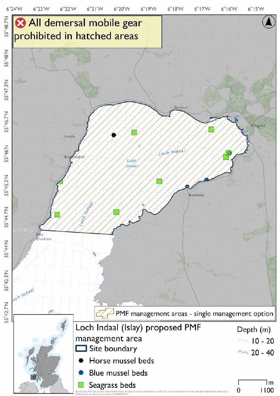
Loch Indaal (Islay) proposed PMF management area covers the inner portion of Loch Indaal, with a southern boundary at Port Charlotte. This area has been selected to protect:
- Horse mussel beds; and
- Seagrass beds
There are also intertidal blue mussel beds present, but they were not considered as part of this process due to there being no overlaps with bottom-contacting fishing activity and intertidal mussel beds.
19.4.2 Fisheries management measures proposed
PMF management areas will be closed to demersal trawls and seines, beam trawls, mechanical dredges, and hydraulic dredges. This is because the features present in these areas are sensitive to these gear types.
19.4.3 Options under consideration
A single management option has been developed for this PMF management area. Only one option was identified due to one of, or combination of, evidence (fishing activity or PMF related), boundary setting principles and compliance considerations.
No additional fishing data were received within the proposed PMF management area.
19.4.4 Other fisheries management measures currently applying to this area
There are already management measures in place. An effort has been made to identify existing measures which affect each individual site or area, however the list may not be exhaustive. These measures are outlined below, and the proposals for further management being consulted on now are in addition to these existing measures:
- Fishing for sandeel is prohibited within the Scottish zone, which is defined as the sea adjacent to Scotland up to the 200 nautical miles limit
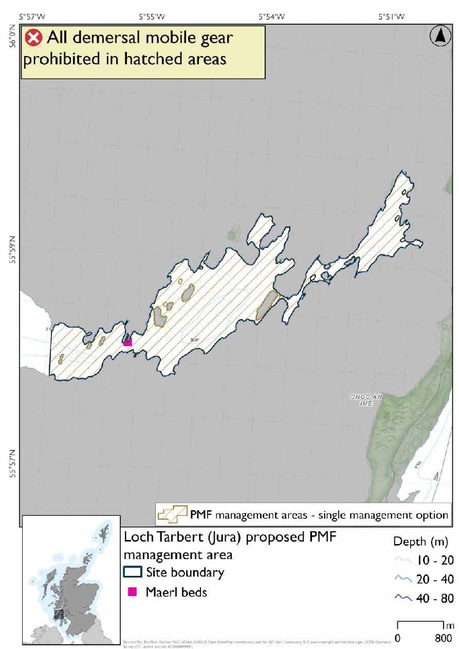
19.5 Loch Tarbert (Jura) proposed PMF management area
19.5.1 Description and background
Loch Tarbert (Jura) proposed PMF management area covers the waters of Loch Tarbert with its outer boundary 1.5km east of Glenbatrick. This area has been selected to protect:
- Maerl beds
19.5.2 Fisheries management measures proposed
PMF management areas will be closed to demersal trawls and seines, beam trawls, mechanical dredges, and hydraulic dredges. This is because the features present in these areas are sensitive to these gear types.
19.5.3 Options under consideration
A single management option has been developed for this PMF management area. Only one option was identified due to one of, or combination of, evidence (fishing activity or PMF related), boundary setting principles and compliance considerations.
Based on available evidence NatureScot suggested this PMF management area could be reduced to include the rapids area and inner basins only. Fishing data were also used and amendments were made to reduce the area.
19.5.4 Other fisheries management measures currently applying to this area
There are already management measures in place. An effort has been made to identify existing measures which affect each individual site or area, however the list may not be exhaustive. These measures are outlined below, and the proposals for further management being consulted on now are in addition to these existing measures:
- Fishing for sandeel is prohibited within the Scottish zone, which is defined as the sea adjacent to Scotland up to the 200 nautical miles limit
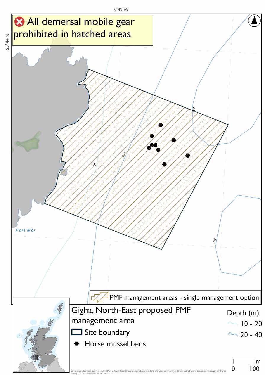
19.6 Gigha, North-East proposed PMF management area
19.6.1 Description and background*
Gigha, North-East proposed PMF management area covers a small area of waters off the North east coast of Gigha, west of Kintyre. This area has been selected to protect:
- Horse mussel beds
*This proposed PMF management area overlaps with the Sound of Gigha SPA.
19.6.2 Fisheries management measures proposed
PMF management areas will be closed to demersal trawls and seines, beam trawls, mechanical dredges, and hydraulic dredges. This is because the features present in these areas are sensitive to these gear types.
This PMF management area overlaps with management measures being consulted on for Sound of Gigha SPA for set nets (including fyke nets) which are not shown in the map below.
Please check overlapping site map option(s) to see static gear measures.
19.6.3 Options under consideration
A single management option has been developed for this PMF management area. Only one option was identified due to one of, or combination of, evidence (fishing activity or PMF related), boundary setting principles and compliance considerations.
The area was reshaped to include the unprotected beds from a 2019 survey. No additional fishing data were provided within the proposed PMF management area.
19.6.4 Other fisheries management measures currently applying to this area
There are already management measures in place. An effort has been made to identify existing measures which affect each individual site or area, however the list may not be exhaustive. These measures are outlined below, and the proposals for further management being consulted on now are in addition to these existing measures:
- Fishing for sandeel is prohibited within the Scottish zone, which is defined as the sea adjacent to Scotland up to the 200 nautical miles limit
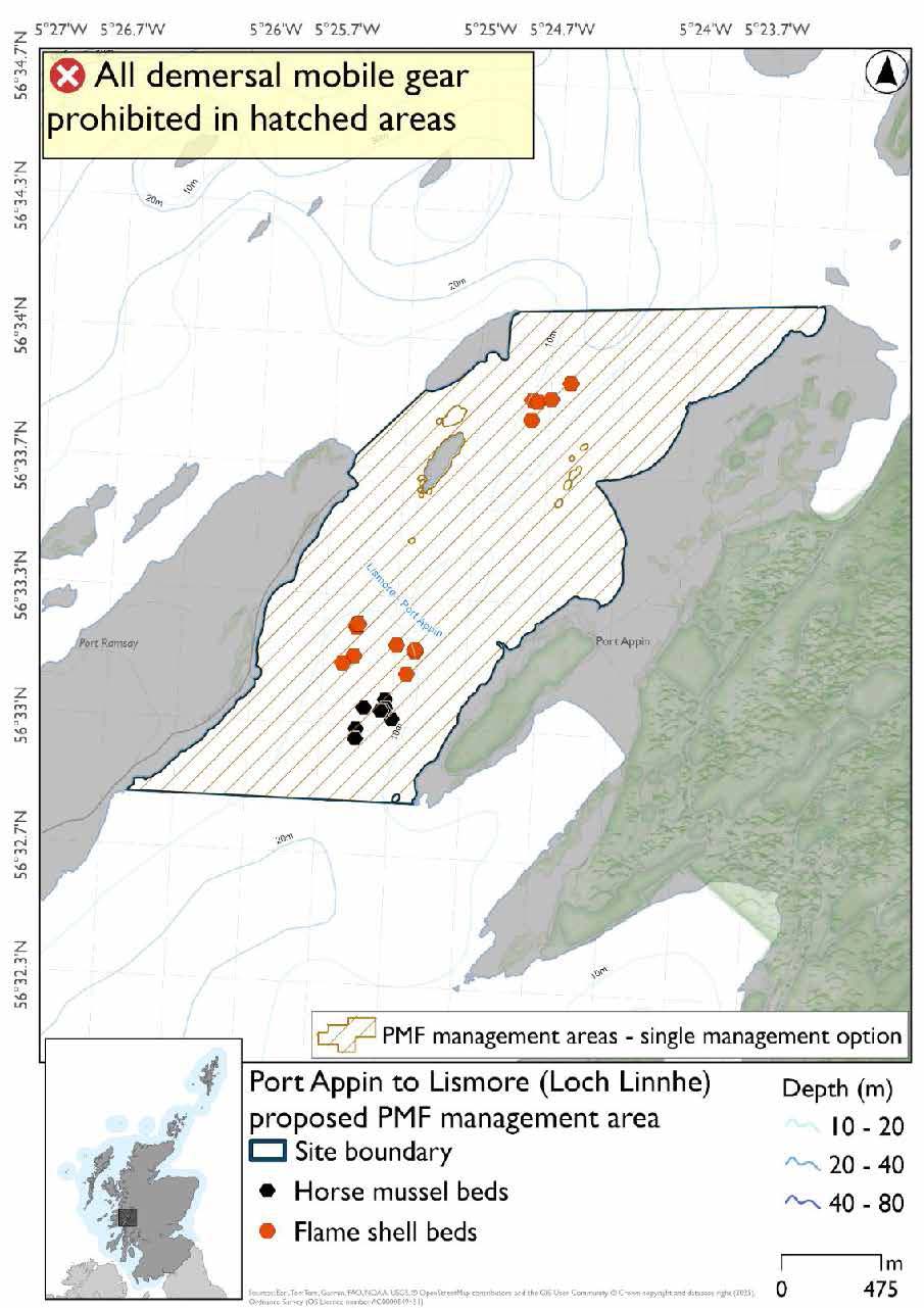
19.7 Port Appin to Lismore (Loch Linnhe) proposed PMF management area
19.7.1 Description and background
Port Appin to Lismore (Loch Linnhe) proposed PMF management area protects the waters between Port Appin and the island of Lismore. This area has been selected to protect:
- Flame shell beds; and
- Horse mussel beds
19.7.2 Fisheries management measures proposed
PMF management areas will be closed to demersal trawls and seines, beam trawls, mechanical dredges, and hydraulic dredges. This is because the features present in these areas are sensitive to these gear types.
19.7.3 Options under consideration
A single management option has been developed for this PMF management area. Only one option was identified due to one of, or combination of, evidence (fishing activity or PMF related), boundary setting principles and compliance considerations.
No additional fishing data were provided within the proposed PMF management area.
19.7.4 Other fisheries management measures currently applying to this area
There are already management measures in place. An effort has been made to identify existing measures which affect each individual site or area, however the list may not be exhaustive. These measures are outlined below, and the proposals for further management being consulted on now are in addition to these existing measures:
- Fishing for sandeel is prohibited within the Scottish zone, which is defined as the sea adjacent to Scotland up to the 200 nautical miles limit
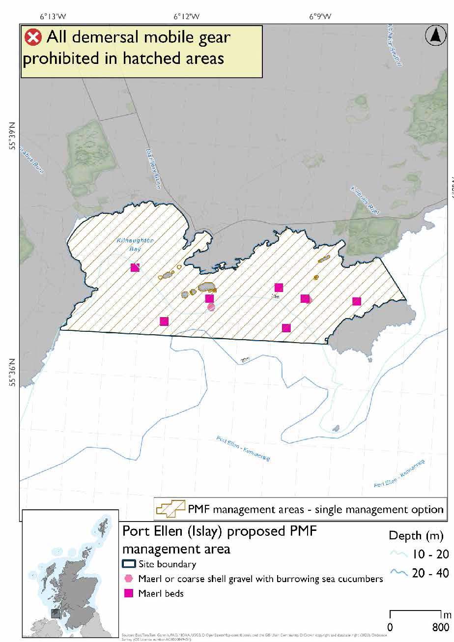
19.8 Port Ellen (Islay) proposed PMF management area
19.8.1 Description and background
Port Ellen (Islay) proposed PMF management area covers the waters surrounding Port Ellen as far as Kilnaughton in the west and Texa in the east. This area has been selected to protect:
- Maerl beds; and
- Maerl or coarse shell gravel with burrowing sea cucumbers
19.8.2 Fisheries management measures proposed
PMF management areas will be closed to demersal trawls and seines, beam trawls, mechanical dredges, and hydraulic dredges. This is because the features present in these areas are sensitive to these gear types.
19.8.3 Options under consideration
A single management option has been developed for this PMF management area. Only one option was identified due to one of, or combination of, evidence (fishing activity or PMF related), boundary setting principles and compliance considerations.
The 2018 illustrative area was reshaped based on records of maerl beds and maerl and coarse shell gravel with burrowing sea cucumbers. No additional fishing data were provided within the proposed PMF management area.
Figure 134. Port Ellen (Islay) proposed PMF management area
19.8.4 Other fisheries management measures currently applying to this area
There are already management measures in place. An effort has been made to identify existing measures which affect each individual site or area, however the list may not be exhaustive. These measures are outlined below, and the proposals for further management being consulted on now are in addition to these existing measures:
- Fishing for sandeel is prohibited within the Scottish zone, which is defined as the sea adjacent to Scotland up to the 200 nautical miles limit
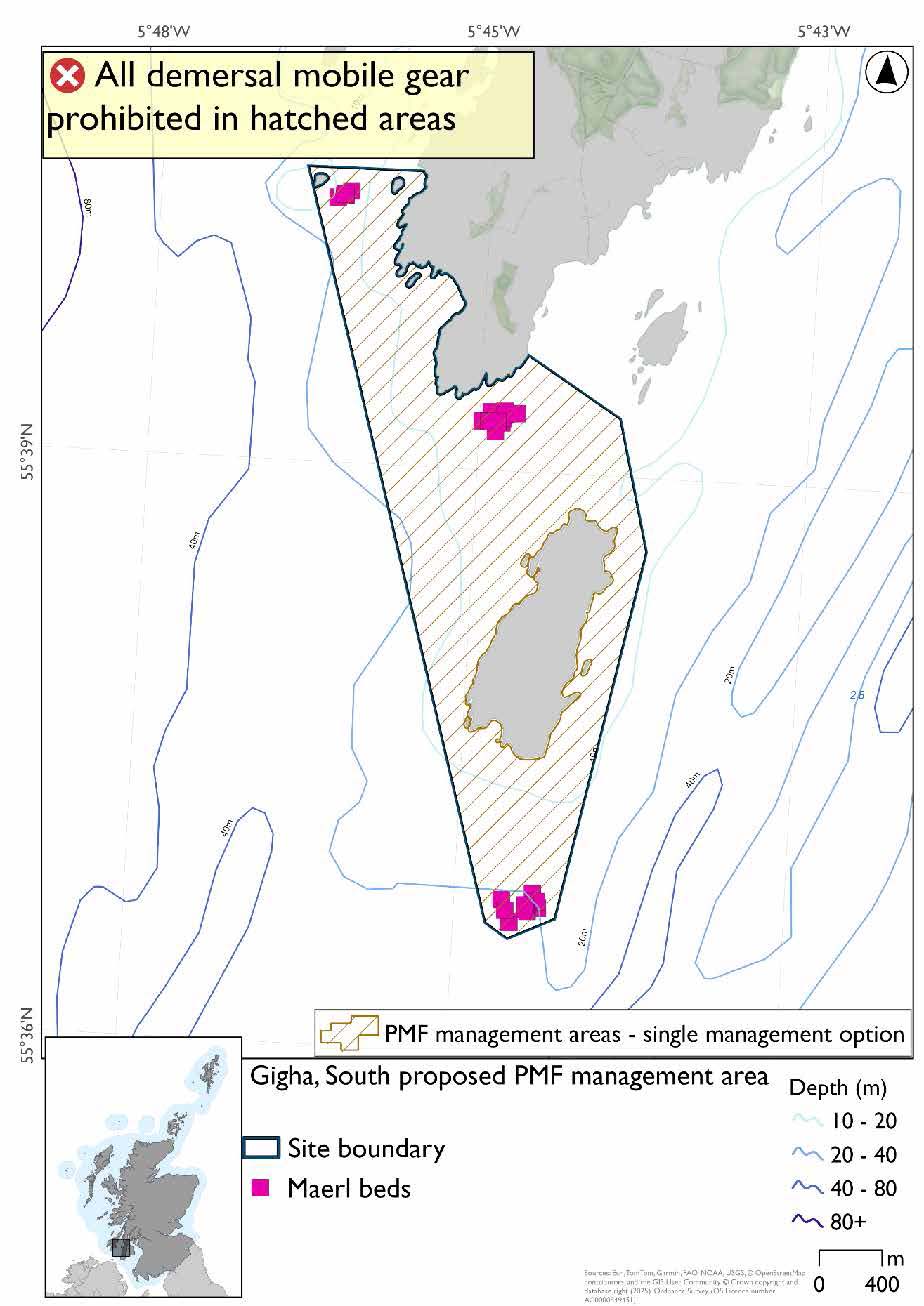
19.9 Gigha, South, proposed PMF management area
19.9.1 Description and background*
Gigha, South, proposed PMF management area stretches from the southern tip of Gigha around Cara island. This area has been selected to protect:
- Maerl beds
*This proposed PMF management area overlaps with the Sound of Gigha SPA.
19.9.2 Fisheries management measures proposed
PMF management areas will be closed to demersal trawls and seines, beam trawls, mechanical dredges, and hydraulic dredges. This is because the features present in these areas are sensitive to these gear types.
This PMF management area overlaps with management measures being consulted on for Sound of Gigha SPA for set nets (including fyke nets) which are not shown in the map below.
Please check overlapping site map option(s) to see static gear measures.
19.9.3 Options under consideration
A single management option has been developed for this PMF management area. Only one option was identified due to one of, or combination of, evidence (fishing activity or PMF related), boundary setting principles and compliance considerations.
This proposed area was developed around the distribution of maerl bed records and adjustments were made to avoid the majority of the fishing activity data provided whilst still protecting all records.
19.9.4 Other fisheries management measures currently applying to this area
There are already management measures in place. An effort has been made to identify existing measures which affect each individual site or area, however the list may not be exhaustive. These measures are outlined below, and the proposals for further management being consulted on now are in addition to these existing measures:
- Fishing for sandeel is prohibited within the Scottish zone, which is defined as the sea adjacent to Scotland up to the 200 nautical miles limit
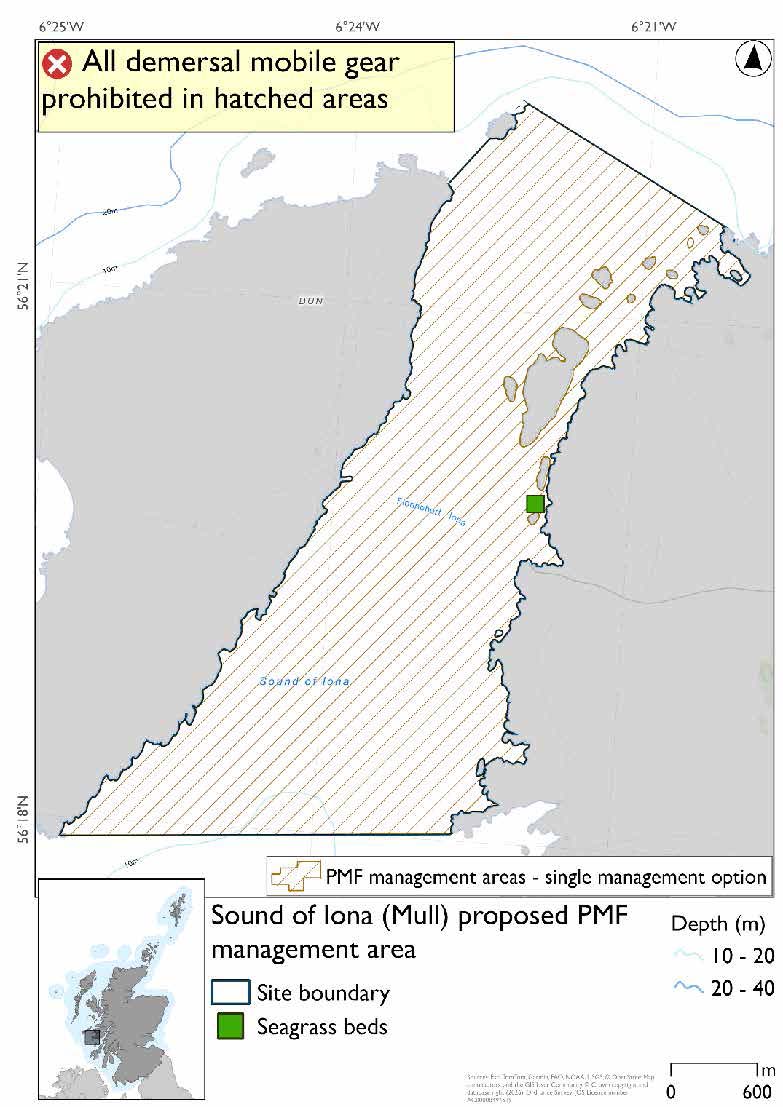
19.10 Sound of Iona (Mull) proposed PMF management area
19.10.1 Description and background*
Sound of Iona (Mull) proposed PMF management area covers the strait between Iona and Mull. This area has been selected to protect:
- Seagrass beds
*This proposed PMF management area overlaps with the Sea of the Hebrides NCMPA and Inner Hebrides and the Minches SAC.
19.10.2 Fisheries management measures proposed
PMF management areas will be closed to demersal trawls and seines, beam trawls, mechanical dredges, and hydraulic dredges. This is because the features present in these areas are sensitive to these gear types.
This is an area where the protection of seagrass beds contributes to the management required for the Inner Hebrides Carbonate Production Area of the Sea of the Hebrides NCMPA.
This PMF management area overlaps with management measures being consulted on for Inner Hebrides and the Minches SAC and Sea of the Hebrides NCMPA for set nets (not including fyke nets) which are not shown in the map below.
Please check one of the overlapping site map option(s) to see static gear measures. Both sets of maps show the same thing for overlapping portion.
19.10.3 Options under consideration
A single management option has been developed for this PMF management area. Only one option was identified due to one of, or combination of, evidence (fishing activity or PMF related), boundary setting principles and compliance considerations.
NatureScot are aware of further PMF evidence to support this area that did not make the data cut-off date for areas being finalised for consultation. No additional fishing data were provided within the proposed management area.
19.10.4 Other fisheries management measures currently applying to this area
There are already management measures in place. An effort has been made to identify existing measures which affect each individual site or area, however the list may not be exhaustive. These measures are outlined below, and the proposals for further management being consulted on now are in addition to these existing measures:
- Fishing for sandeel is prohibited within the Scottish zone, which is defined as the sea adjacent to Scotland up to the 200 nautical miles limit
19.11 Sound of Islay (Islay) proposed PMF management area
19.11.1 Description and background*
Sound of Islay (Islay) proposed PMF management area covers the strait between Islay and Jura. This area has been selected to protect:
- Maerl beds
*This proposed PMF management area overlaps with the Sea of the Hebrides NCMPA and Inner Hebrides and the Minches SAC.
19.11.2 Fisheries management measures proposed
PMF management areas will be closed to demersal trawls and seines, beam trawls, mechanical dredges, and hydraulic dredges. This is because the features present in these areas are sensitive to these gear types.
This PMF management area overlaps with management measures being consulted on for Inner Hebrides and the Minches SAC and Sea of the Hebrides NCMPA for set nets (not including fyke nets) which are not shown in the maps below.
Please check one of the overlapping site map option(s) to see static gear measures. Both sets of maps show the same thing for overlapping portion.
19.11.3 Options under consideration
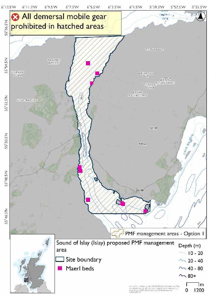
Two options have been developed for this for this PMF management area. Option 1 reflects a smaller footprint that reflects one, or a combination of evidence (fishing activity or PMF related), boundary setting principles and compliance considerations.
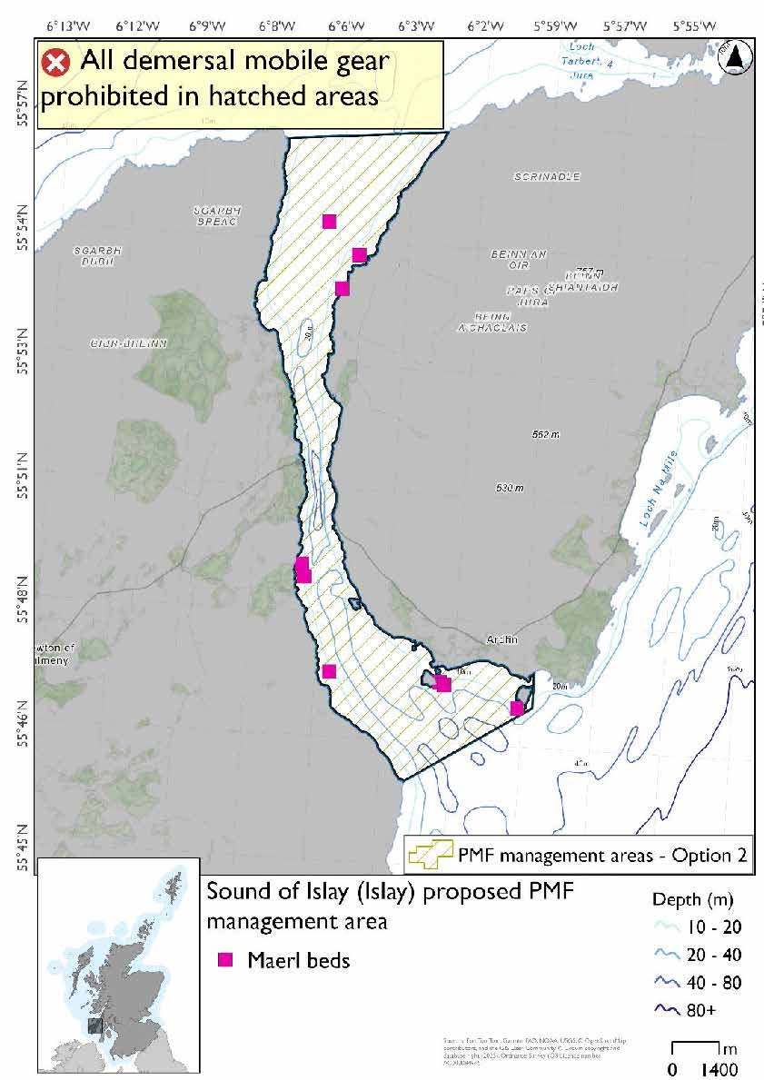
Option 2 covers a larger footprint that offers improved protection.
Option 1: This boundary covers a smaller footprint more closely following the known records of PMFs in the southern end of the sound. Additional fishing data were provided and amendments were made in the southern end of the area to enable the majority of this activity to continue, whilst protecting the records.
Option 2: This boundary covers a larger footprint, with an extended boundary in the south west that offers improved protection.
19.11.4 Other fisheries management measures currently applying to this area
There are already management measures in place. An effort has been made to identify existing measures which affect each individual site or area, however the list may not be exhaustive. These measures are outlined below, and the proposals for further management being consulted on now are in addition to these existing measures:
- Fishing for sandeel is prohibited within the Scottish zone, which is defined as the sea adjacent to Scotland up to the 200 nautical miles limit
19.12 Ulva and Loch na Keal (Mull) proposed PMF management area
19.12.1 Description and background*
Ulva and Loch na Keal (Mull) proposed PMF management area covers Loch na Keal and the southern coast of the island of Ulva off Mull. This area has been selected to protect:
- Maerl beds;
- Northern sea fan and sponge communities; and
- Seagrass beds
*This proposed PMF management area overlaps with the Sea of the Hebrides NCMPA and Inner Hebrides and the Minches SAC.
19.12.2 Fisheries management measures proposed
PMF management areas will be closed to demersal trawls and seines, beam trawls, mechanical dredges, and hydraulic dredges. This is because the features present in these areas are sensitive to these gear types.
This is an area where the protection of the maerl and seagrass beds contributes to the management required for the Inner Hebrides Carbonate Production Area of the Sea of the Hebrides NCMPA.
This PMF management area overlaps with management measures being consulted on for Inner Hebrides and the Minches SAC and Sea of the Hebrides NCMPA for set nets (not including fyke nets) which are not shown in the maps below.
Please check both site map options to see static gear measures. Each map will show the same overlapping measures but cover different areas.
19.12.3 Options under consideration
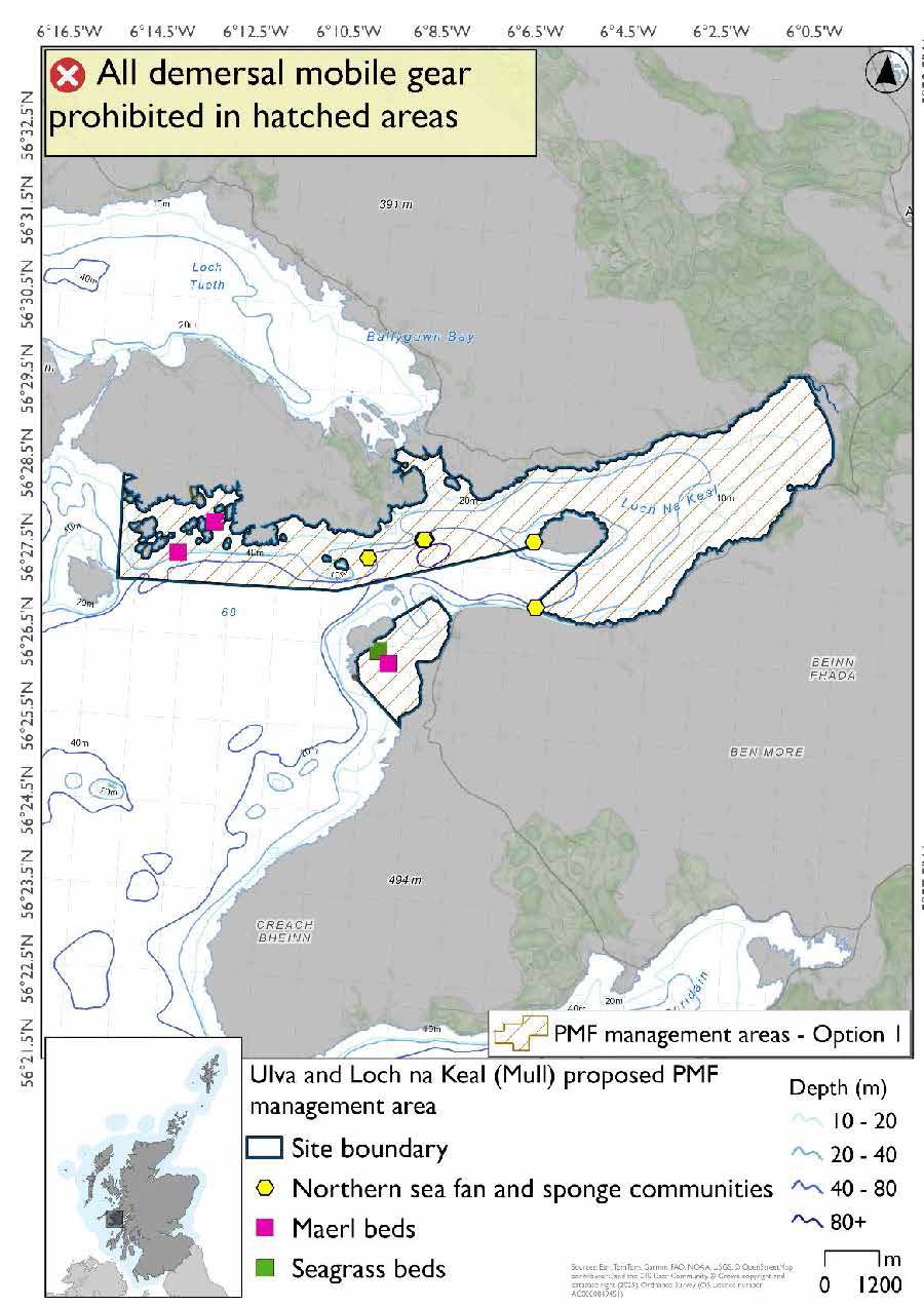
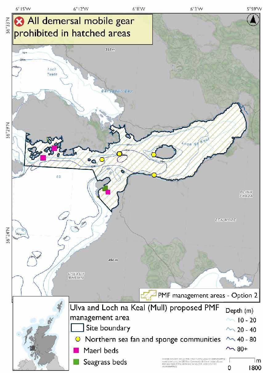
Two options have been developed for this for this PMF management area. Option 1 reflects a smaller footprint that reflects one, or a combination of evidence (fishing activity or PMF related), boundary setting principles and compliance considerations. Option 2 covers a larger footprint that offers improved protection.
Option 1: This boundary covers a smaller footprint over two discrete areas that reflects the extent of PMF records. Additional fishing data provided showed activity in the middle area, south of Ulva and into Loch na Keal and therefore option 1 was split into two areas. The two northern sea fan and sponge community records at Eorsa may have natural protection from the rocky outcrops here and so the decision was taken to position the boundary to still afford protection but enable fishing activity.
Option 2: This boundary covers a larger footprint that offers improved protection.
19.12.4 Other fisheries management measures currently applying to this area
There are already management measures in place. An effort has been made to identify existing measures which affect each individual site or area, however the list may not be exhaustive. These measures are outlined below, and the proposals for further management being consulted on now are in addition to these existing measures:
- Fishing for sandeel is prohibited within the Scottish zone, which is defined as the sea adjacent to Scotland up to the 200 nautical miles limit
19.13 West Loch Tarbert (Kintyre) proposed PMF management area
19.13.1 Description and background*
West Loch Tarbert (Kintyre) proposed PMF management area covers the sheltered waters of West Loch Tarbert as far out as Ronachan. This area has been selected to protect:
- Maerl beds; and
- Seagrass beds
*This proposed PMF management area overlaps with the Sound of Gigha SPA and Inner Hebrides and the Minches SAC.
19.13.2 Fisheries management measures proposed
PMF management areas will be closed to demersal trawls and seines, beam trawls, mechanical dredges, and hydraulic dredges. This is because the features present in these areas are sensitive to these gear types.
This PMF management area overlaps with management measures being consulted on for Sound of Gigha SPA for set nets (including fyke nets) and Inner Hebrides and the Minches SAC for set nets (not including fyke nets) which are not shown in the maps below.
Please check overlapping site map option(s) to see to see static gear measures.
19.13.3 Options under consideration
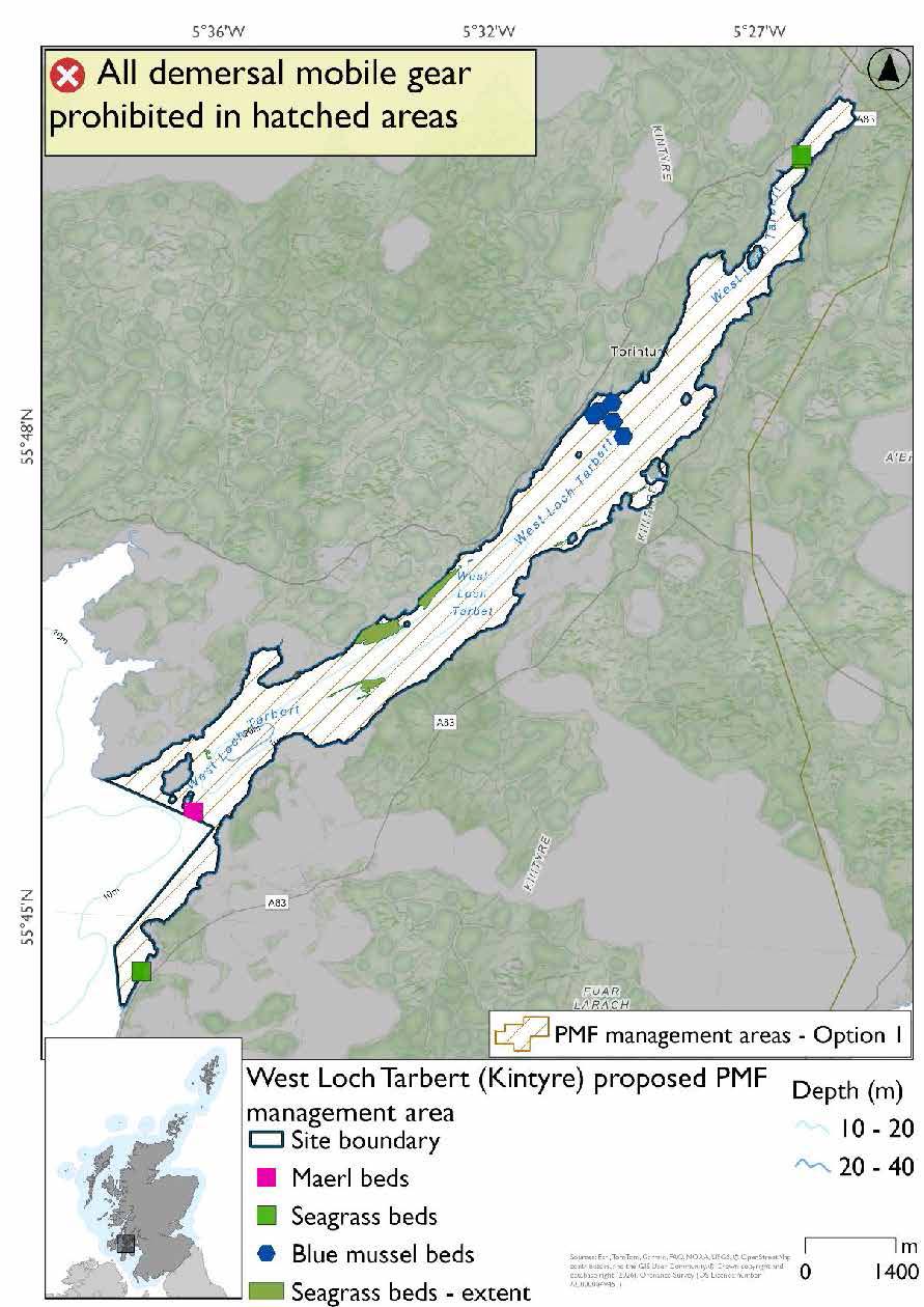
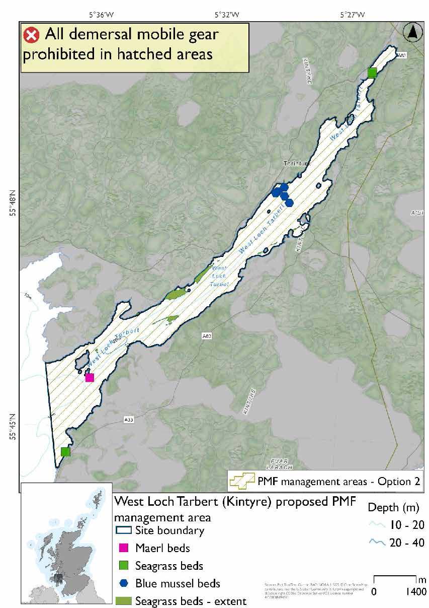
Two options have been developed for this for this PMF management area. Option 1 reflects a smaller footprint that reflects one, or a combination of evidence (fishing activity or PMF related), boundary setting principles and compliance considerations. Option 2 covers a larger footprint that offers improved protection.
Option 1: This boundary covers a smaller footprint, more closely following depths suitable for the PMFs at the mouth of the loch. This area was reduced to accommodate additional fishing data provided without impacting on known records.
Option 2: This boundary covers a larger footprint that offers improved protection.
19.13.4 Other fisheries management measures currently applying to this area
There are already management measures in place. An effort has been made to identify existing measures which affect each individual site or area, however the list may not be exhaustive. These measures are outlined below, and the proposals for further management being consulted on now are in addition to these existing measures:
- Fishing for sandeel is prohibited within the Scottish zone, which is defined as the sea adjacent to Scotland up to the 200 nautical miles limit
Contact
Email: marine_biodiversity@gov.scot