
Fisheries Management Measures within Scottish Inshore Marine Protected Areas (MPAs) and Proposed Priority Marine Feature (PMF) Management Areas - Site and Area Proposal Document
This document describes the process, justification and evidence used to develop site and area specific fisheries management measures. It outlines key information for each site and area including their features, and risks of potential pressures.

17. Sites in the West Highlands Region
17.1 Small Isles NCMPA
17.1.1 Description and background
The Small Isles NCMPA is located off the west coast of Scotland and encompasses waters surrounding the islands of Canna and Rum, including the Sound of Canna. The site covers over 800 km² and forms part of Scotland’s network of MPAs designated to protect nationally important marine habitats and species.
The NCMPA is of particular significance for supporting the largest known aggregation of fan mussels in UK waters, located within the deep, tide‑swept waters of the Sound of Canna. Fan mussels are a PMF and one of the UK’s most threatened molluscs, occurring embedded in muddy or mixed sediments, where only part of the shell protrudes above the seabed to filter feed.
The seabed within the NCMPA is highly varied and reflects a complex glacial and sedimentary environment. A prominent submerged glacial valley (‘shelf deep’) extends north from the Sound of Canna, with steep sides and a flat basin floor. The vertical slopes support diverse communities including northern sea fan and sponge assemblages, while the basin floor is characterised by circalittoral sand and mud habitats and burrowed mud, often containing seapens and burrowing megafauna.
The NCMPA supports a range of Priority Marine Features, including:
- Fan mussel aggregations
- Burrowed mud and circalittoral sand and mud communities
- Horse mussel beds
- Northern sea fan and sponge communities
- Northern feather star aggregations
Notably, the Sound of Canna contains deep horse mussel beds and areas of high benthic diversity, contributing to the site’s ecological importance.
The NCMPA overlaps with adjacent seabird SPAs (Rum; Canna and Sanday), and its marine waters provide habitat for species such as black guillemot, which is a designated feature within the protected area.
The reflects the distribution of these protected habitats and species, encompassing the key seabed features and geological structures that underpin them. The inclusion of the Sound of Canna and surrounding waters ensures protection of the supporting habitat mosaic and ecological processes, including sediment dynamics and oceanographic conditions that sustain PMF species and benthic communities.
Further information, including Conservation and Management Advice (CMA) can be found on Sitelink.
Further information on MPAs, the wider network and protected areas management is available at Scottish Government MPA policy page.
17.1.2 Protected features
The Small Isles MPA has been designated to protect eight biodiversity features, one large scale feature and one geodiversity feature:
- Black guillemot;
- Burrowed mud;
- Circalittoral sand and mud communities;
- Fan mussel aggregations;
- Horse mussel beds;
- Northern feather star aggregations on mixed substrata;
- Northern sea fan and sponge communities;
- Quaternary of Scotland
- Shelf deeps; and
- White cluster anemones
Quaternary of Scotland and shelf deeps are not discussed further as they are not protected features for which fisheries management measures are required.
17.1.3 Conservation Objectives
All of the biodiversity features, with the exception of black guillemot, are in favourable condition at Small Isles MPA and therefore the Conservation Objectives seek to conserve this condition.
Black guillemot are in unfavourable condition at the Small Isles MPA and therefore Conservation Objectives seek to recover this condition.
Additional details, including the Conservation Objectives are provided in the Conservation and Management Advice document produced for this NCMPA and can be found on Sitelink.
17.1.4 Pressure from fishing activity
Fishing activities can exert a range of pressures on protected marine features, with the most significant impacts seen in species and habitats sensitive to physical disturbance and habitat degradation. The black guillemot, a coastal seabird, is particularly sensitive to bycatch in fishing nets and disturbance from vessel movements. Its reliance on inshore feeding grounds and prey-rich habitats like kelp forests heightens its sensitivity to fishing-related changes.
Benthic habitats such as burrowed mud and circalittoral sand and mud communities are highly susceptible to bottom-contact fishing gear. Physical disturbance can damage filter-feeding species, reduce biodiversity, and alter sediment structure through increased siltation and disrupted water flow. Organic enrichment from fishing residues further threatens these habitats by degrading oxygen exchange and nutrient balance.
Fragile biogenic features like fan mussel aggregations, horse mussel beds, and northern feather star assemblages are especially sensitive. Fan mussels are easily damaged by seabed abrasion and show minimal recovery. Horse mussel beds suffer from smothering and slow recruitment, while feather stars are sensitive to sedimentation and abrasion, with population-level recovery taking years.
Sessile communities such as northern sea fans, sponges, and white cluster anemones are also at risk from physical disturbance and sedimentation linked to fishing. These organisms may be detached or suffocated, and recovery is slow due to poor recruitment and growth rates.
Additional details are provided in the Conservation and Management Advice document produced for this NCMPA (section 6) and can be found on Sitelink.
- The Feature Activity Sensitivity Tool (FeAST) which allows users to investigate the sensitivity of marine features (habitats, species, geology and landforms) in Scotland's seas, to pressures arising from human activities;
- Fisheries Guidance Notes which provide summaries of evidence on the interaction between fishing gears and specific habitats and species.
17.1.5 Fisheries management advice relevant to proposed fisheries management measures
NatureScot provides risk-based advice to help manage activities that may impact protected features and their Conservation Objectives. See section 2.3 for more detail. The CMA document also sets out the full fisheries management advice that has been summarised below for the management measures proposed:
Demersal mobile/active gear
Black guillemot - reduce or limit pressures (removal of prey species and abrasion of prey-supporting habitat) associated with fishing that has the potential to damage seabed habitat (in particular, sandeel habitat, herring spawning grounds) should be considered.
Burrowed mud - reduce or limit pressures associated with mobile and active fishing on burrowed mud habitats should be considered. Where there are aggregations of tall sea pens, management measures to reduce or limit mobile/active gear is recommended.
Circalittoral sand and mud communities - reduce or limit pressures associated with mobile and active gears is recommended.
Horse mussel beds and northern sea fan and sponge communities - remove or avoid pressures associated with demersal mobile and active fishing is recommended.
Northern feather star aggregations on mixed substrate - reduce or limit pressures associated with demersal mobile and active fishing should be considered.
Fan mussels and white cluster anemone - remove or avoid pressures associated with demersal mobile and active fishing is recommended.
Hydraulic (diver or vessel)
Remove or avoid pressures (removal of prey species and disturbance of prey-supporting habitat) associated with hydraulic fishing that has the potential to damage seabed habitat (in particular, sandeel habitat) is recommended.
Reduce or limit pressures associated with hydraulic fishing should be considered for burrowed mud northern feather star aggregations on mixed substrata and circalittoral sand and coarse sediment communities.
Remove or avoid pressures. The exclusion of hydraulic fishing from the areas within the site where horse mussel beds, fan mussel, white cluster anemones and northern sea fan and sponge communities occur is recommended.
Static gear
Remove or avoid pressures (entanglement) associated with the use of all static nets (including bottom set nets, drift nets, fyke nets). Spatial exclusion of all static nets in areas identified as being important for black guillemot (as identified from habitat and dive depth preferences) is recommended.
17.1.6 Proposed fisheries management measures
The proposed management measures for Small Isles NCMPA are as follows:
Option 1
- Demersal trawl and mechanical dredge by vessels with engine power over 500 kW prohibited throughout site
- Demersal trawl and mechanical dredge by vessels with engine power 500 kW or less permitted in part of the site
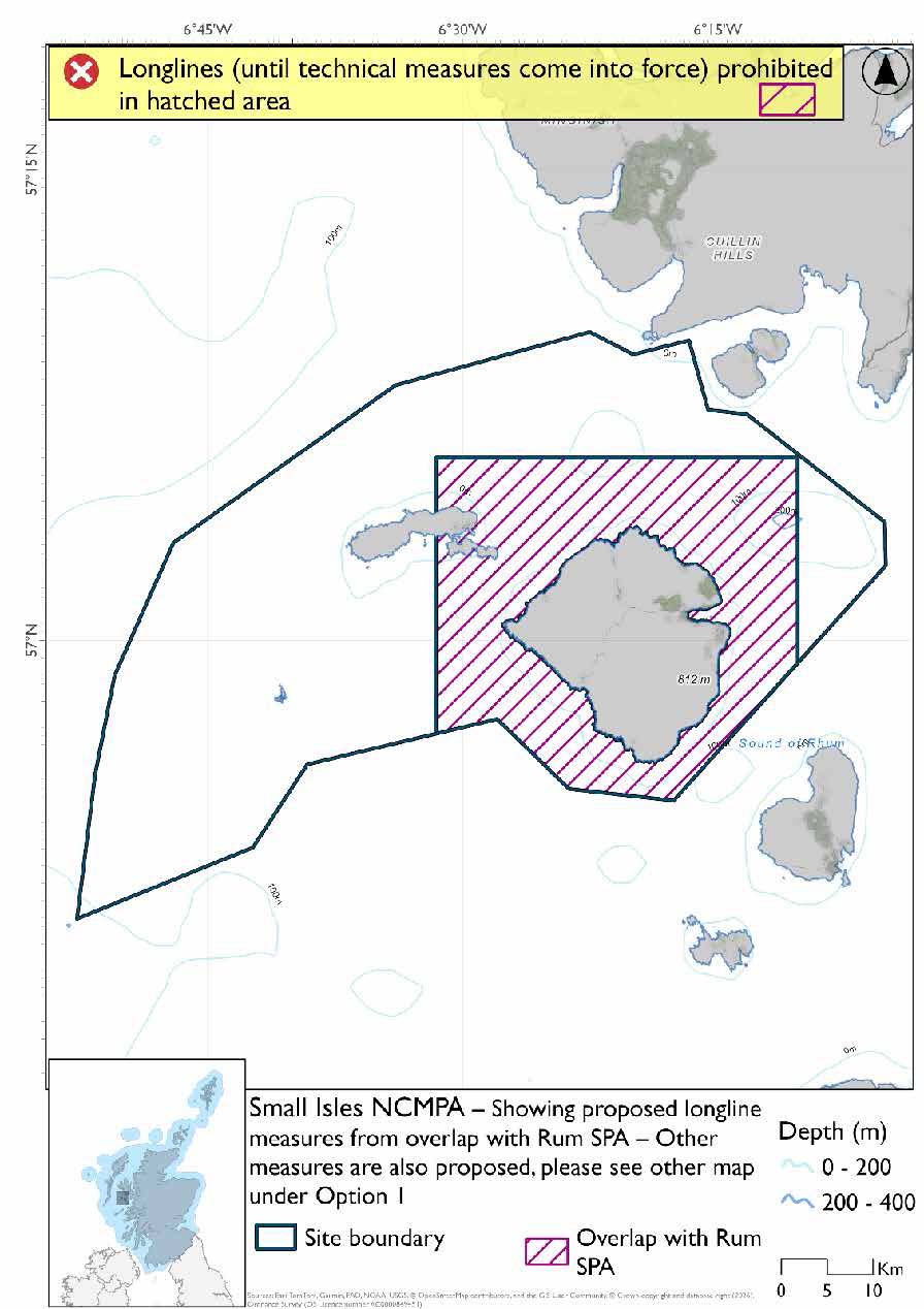
- Longlines (until technical measures come into force) prohibited in overlapping areas with Rum SPA
- Full site closure to demersal seine, beam trawls, set nets (including fyke nets) and hydraulic dredge
Figure 113. Map of measures proposed under option 1
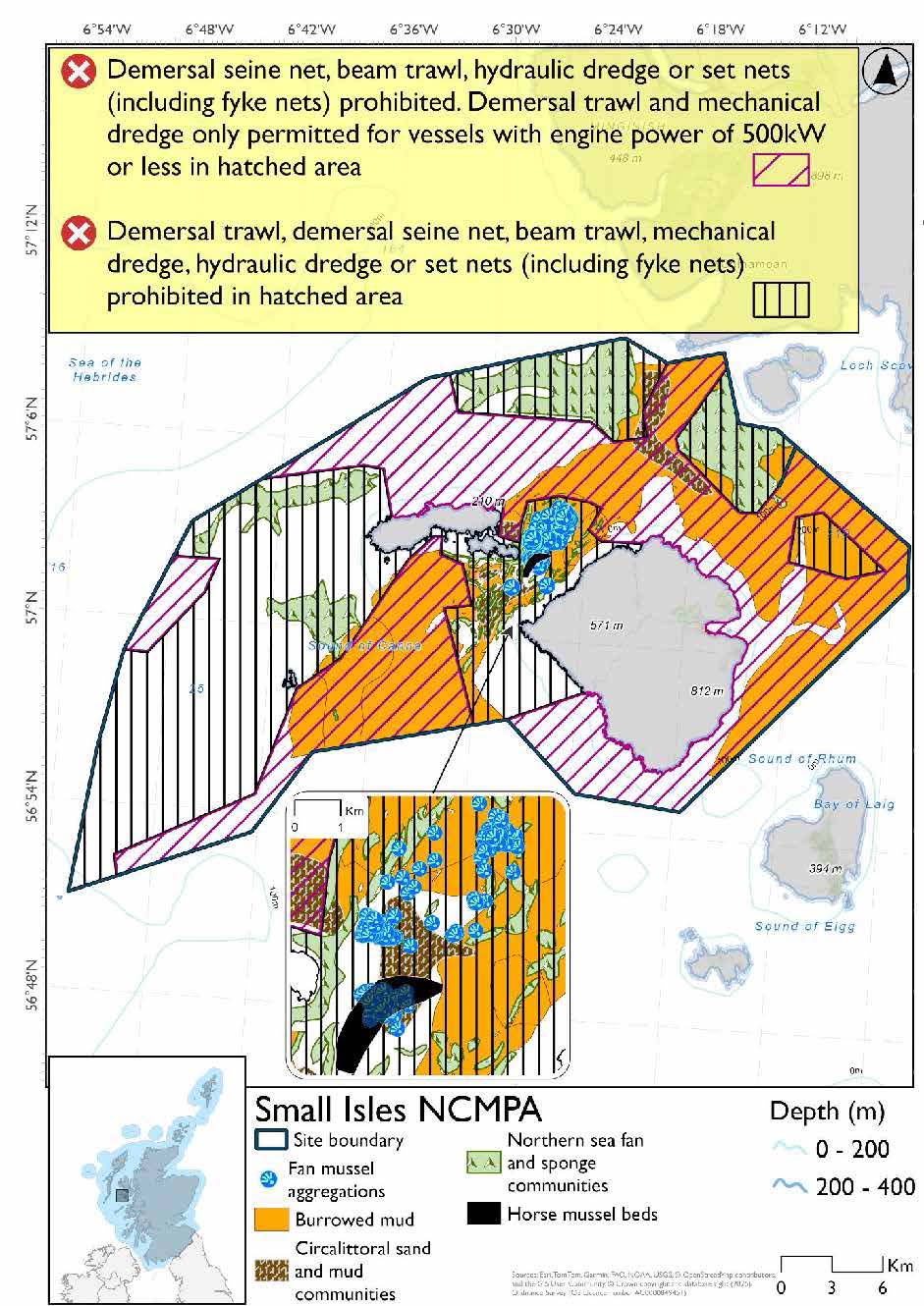
Figure 114. Map of longline measures (until technical measures come into force) from overlapping SPA proposed under option 1
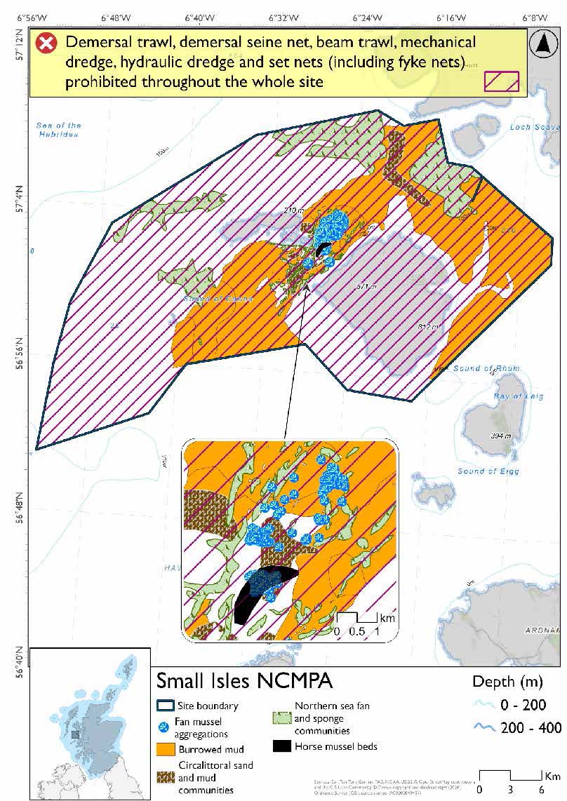
Option Two*
- Full site closure to demersal trawl and seine, beam trawls, mechanical dredge, hydraulic dredge and set nets (including fyke nets)
Figure 115. Map of measures proposed under option 2
*The measures for Option 2 proposals only come from gear types prohibited in non-overlapping areas. Overlapping restrictions may still apply from overlapping sites or areas dependent on the decisions taken for that site or area.
Overlapping sites included in this consultation
This NCMPA overlaps with the Canna and Sanday and Rum SPAs, Sea of the Hebrides NCMPA and Inner Hebrides and the Minches SAC.
Rationale for developed measures
The basis for the proposed fisheries management measures for each site has been determined by the management advice for fishing activities provided by NatureScot, which can be found on their website or Sitelink as signposted throughout this document. The Fisheries Assessment for each site assesses the impacts from existing fishing activities on the protected features using the tests from the legislation relevant for the type of MPA being considered. The assessment outlines how the proposed measures address any impacts identified that could hinder the conservation objectives of the MPA.
17.1.7 Other fisheries management measures currently applying to this site
There are already management measures in place. An effort has been made to identify existing measures which affect each individual site or area, however the list may not be exhaustive. These measures are outlined below, and the proposals for further management being consulted on now are in addition to these existing measures:
- Fishing for sandeel is prohibited within the Scottish zone, which is defined as the sea adjacent to Scotland up to the 200 nautical miles limit.
- North western waters: United Kingdom waters of ICES divisions 5b, 6a,7ahj, 200-600m depth Bottom set gillnet, entangling net and trammel net at any position where the charted depth is greater than 200 m in parts of the site.
Other conservation measures can be found in section 7 of the CMA.
17.2 Ascrib, Isay and Dunvegan SAC
17.2.1 Description and background
The Ascrib, Isay and Dunvegan SAC is located off the northwest coast of the Isle of Skye in Scotland. This marine site encompasses a group of small islands, skerries, and coastal waters, covering approximately 2,578 hectares. The SAC supports one of the largest discrete colonies of harbour seals in the UK, representing around 2% of the national population. These seals rely on the site for key life stages, including breeding, pupping, and hauling out. The area's sheltered inlets and undisturbed shores provide ideal conditions for these activities, making it a vital habitat for the long-term survival of the species.
Further information, including Conservation and Management Advice (CMA) can be found on Sitelink.
Further information on MPAs, the wider network and protected areas management is available at Scottish Government MPA policy page.
17.2.2 Protected features
The Ascrib, Isay and Dunvegan SAC has been designated to protect:
- Harbour seal
17.2.3 Conservation Objectives
Harbour seal is in favourable condition at Ascrib, Isay and Dunvegan SAC and therefore the Conservation Objectives seek to maintain this condition.
Additional details, including the Conservation Objectives, are provided in the Conservation and Management Advice document produced for this SAC and can be found on Sitelink.
17.2.4 Pressure from fishing activity
Fishing activities can exert multiple pressures on harbour seals, particularly through entanglement in fishing gear, which can cause injury or death, especially among younger or inexperienced individuals. Underwater noise from vessels and equipment used in fishing operations can disrupt communication, navigation, and foraging, leading to stress and displacement, especially during sensitive periods like breeding and moulting.
Disturbance from fishing-related activity may alter haul-out behaviour, reduce resting time, and in severe cases, lead to site abandonment. During breeding, such disruptions can interrupt lactation or separate mothers from pups, reducing pup survival.
Additional details are provided in the Conservation and Management Advice document produced for this SAC (section 6) and can be found on Sitelink.
Other resources include:
- The Feature Activity Sensitivity Tool (FeAST) which allows users to investigate the sensitivity of marine features (habitats, species, geology and landforms) in Scotland's seas, to pressures arising from human activities;
- Fisheries Guidance Notes which provide summaries of evidence on the interaction between fishing gears and specific habitats and species.
17.2.5 Fisheries management advice relevant to proposed fisheries management measures
NatureScot provides risk-based advice to help manage activities that may impact protected features and their Conservation Objectives. See section 2.3 for more detail. The CMA document also sets out the full fisheries management advice that has been summarised below for the management measures proposed:
Netting (Bottom-set gill nets including tangle and trammel nets. Drift nets, purse seine, ring-nets and fyke nets.)
Reduce or limit pressures (entanglement) associated with the use of nets is recommended.
17.2.6 Proposed fisheries management measures
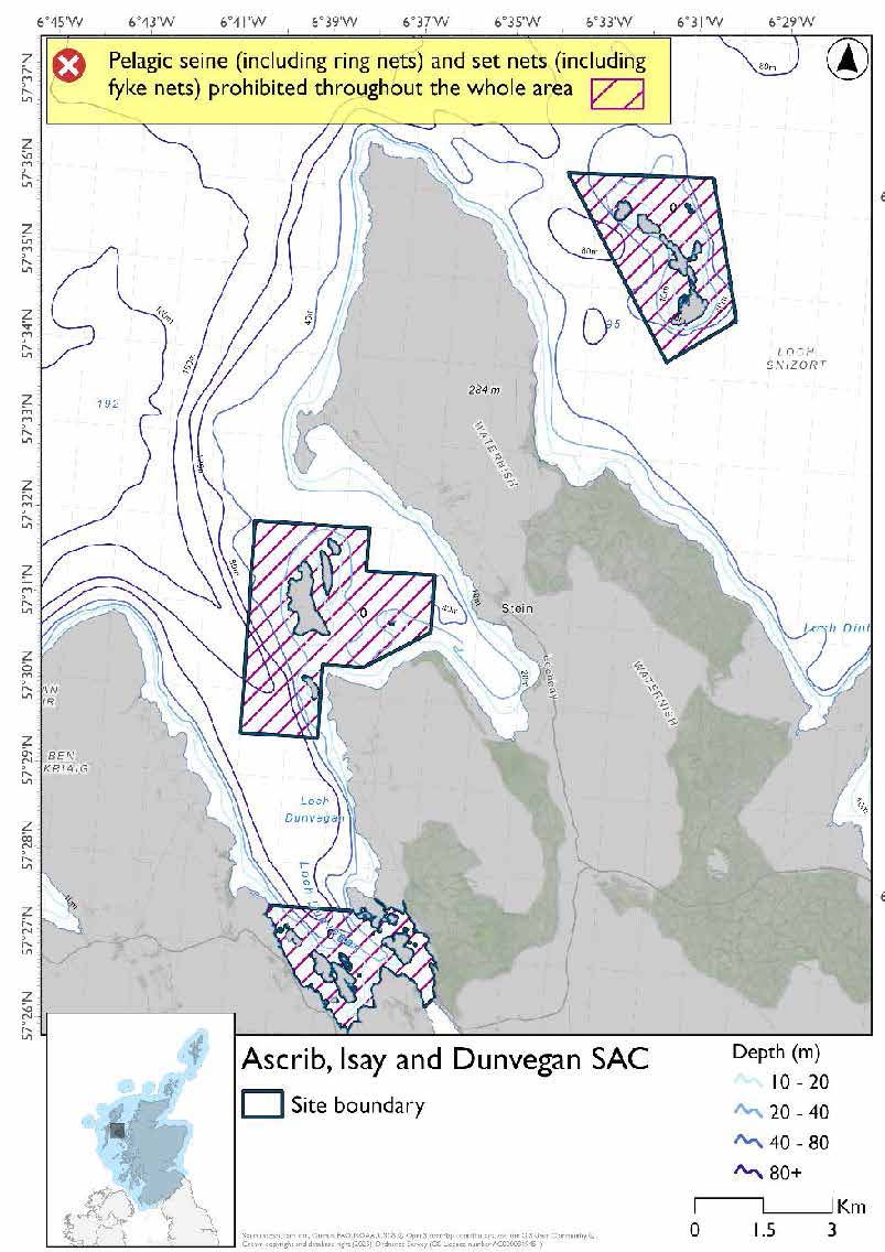
The proposed management measure for Ascrib, Isay and Dunvegan SAC is as follows:
Single Proposed Management Option*
- Full site closure to set nets (including fyke nets) and pelagic seine (including ring-nets)
Figure 116. Map of measures proposed
A full site level of protection from the specified gear has been identified as the only suitable option in enabling the achievement of the desired level of protection for the feature in question.
*This site will have other demersal mobile measures that may apply from the overlapping portions with the Inner Hebrides and the Minches SAC and proposed PMF management areas that aren’t shown on the map for this option.
- Inner Hebrides and the Minches SAC would prohibit hydraulic dredge across the entire site
- The proposed PMF management areas would prohibit all demersal mobile gear from the entire area that overlaps. (see section below for overlapping areas)
Please check the Option 1 or single management overlapping site and area maps to see proposed demersal mobile measures under Option 1.
Overlapping site and areas included in this consultation
This SAC overlaps Inner Hebrides and the Minches SAC and the Loch Bay (Skye), and Ascrib Islands (Skye) proposed PMF management areas.
Rationale for developed measures
The basis for the proposed fisheries management measures for each site has been determined by the management advice for fishing activities provided by NatureScot, which can be found on their website or Sitelink as signposted throughout this document. The Fisheries Assessment for each site assesses the impacts from existing fishing activities on the protected features using the tests from the legislation relevant for the type of MPA being considered. The assessment outlines how the proposed measures address any impacts identified that could hinder the conservation objectives of the MPA.
17.2.6 Other fisheries management measures currently applying to this site
There are already management measures in place. An effort has been made to identify existing measures which affect each individual site or area, however the list may not be exhaustive. These measures are outlined below, and the proposals for further management being consulted on now are in addition to these existing measures:
- Fishing for sandeel is prohibited within the Scottish zone, which is defined as the sea adjacent to Scotland up to the 200 nautical miles limit
Other conservation measures can be found in section 7 of the CMA.
17.3 Inner Hebrides and the Minches SAC
17.3.1 Description and background
The Inner Hebrides and the Minches SAC is located off the west coast of Scotland, extending across the waters between the Inner Hebrides and the north‑west mainland. It covers approximately 1,381,391 hectares and is entirely marine, comprising coastal waters, sea inlets and open shelf seas.
The SAC is designated solely for the protection of harbour porpoise. It is one of the largest protected areas for this species in Europe and makes a significant contribution to the conservation of harbour porpoise with over 500 individuals estimated to use the site regularly.
The site encompasses channels, coastal waters and sea lochs, which together provide suitable conditions for harbour porpoise. These waters support important ecological processes, including foraging, movement and other essential behaviours, underpinned by the availability of prey and the physical characteristics of the marine environment.
As harbour porpoise are wide‑ranging and highly mobile, the SAC does not encompass their full distribution. Instead, it focuses on areas of consistent use, where conservation measures can be most effective in maintaining favourable conservation status. The boundary therefore reflects the spatial distribution of important habitat and ecological conditions rather than fixed physical features.
Further information, including Conservation and Management Advice (CMA) can be found on Sitelink.
Further information on MPAs, the wider network and protected areas management is available at Scottish Government MPA policy page.
17.3.2 Protected features
The Inner Hebrides and the Minches SAC has been designated to protect:
- Harbour porpoise
17.3.3 Conservation Objectives
Harbour porpoise species are in favourable condition at Inner Hebrides and the Minches SAC and therefore the Conservation Objectives seek to maintain this condition.
Additional details, including the Conservation Objectives, are provided in the Conservation and Management Advice document produced for this SAC and can be found on Sitelink.
17.3.4 Pressure from fishing activity
Fishing activities can exert multiple pressures on harbour porpoises, particularly in coastal areas where they are more densely distributed. One of the most significant threats is entanglement in fishing gear, which can lead to injury or death. This includes both direct bycatch and the indirect impact of reduced prey availability due to overfishing, which can compromise survival and reproductive success.
Additionally, underwater noise from fishing vessels and acoustic equipment can disrupt echolocation, a critical behaviour for navigation and foraging. This acoustic disturbance may lead to stress, displacement, or reduced feeding efficiency. While not exclusive to fishing, collisions with fast-moving vessels used in commercial and recreational fisheries also present a physical threat.
Additional details are provided in the Conservation and Management Advice document produced for this SAC (section 6) and can be found on Sitelink.
Other resources include:
- The Feature Activity Sensitivity Tool (FeAST) which allows users to investigate the sensitivity of marine features (habitats, species, geology and landforms) in Scotland's seas, to pressures arising from human activities;
- Fisheries Guidance Notes which provide summaries of evidence on the interaction between fishing gears and specific habitats and species.
17.3.5 Fisheries management advice relevant to proposed fisheries management measures
NatureScot provides risk-based advice to help manage activities that may impact protected features and their Conservation Objectives. See section 2.3 for more detail. The CMA document also sets out the full fisheries management advice that has been summarised below for the management measures proposed:
Hydraulic (diver or vessel)
Remove or avoid pressures. The exclusion of hydraulic fishing methods from the habitat of sandeels (as a key prey species of harbour porpoise) within the site is recommended.
Static gear
Reduce or limit pressures. Exclusion of the use of drift nets and nets set on the seabed (tangle, trammel, gill) to avoid the risk of entanglement and/or bycatch of harbour porpoise is recommended. Existing bycatch legislation and mitigation applies to certain fisheries.
Pelagic gear
The risk of entanglement/bycatch catch of harbour porpoise should be reduced or limited through the development and adoption of best practice should be considered. Existing bycatch legislation and mitigation applies to certain fisheries.
Management measures ensuring that fishing activity does not prevent or disrupt the availability of key prey species (e.g. herring, sprat) for harbour porpoise are recommended.
17.3.6 Proposed fisheries management measures
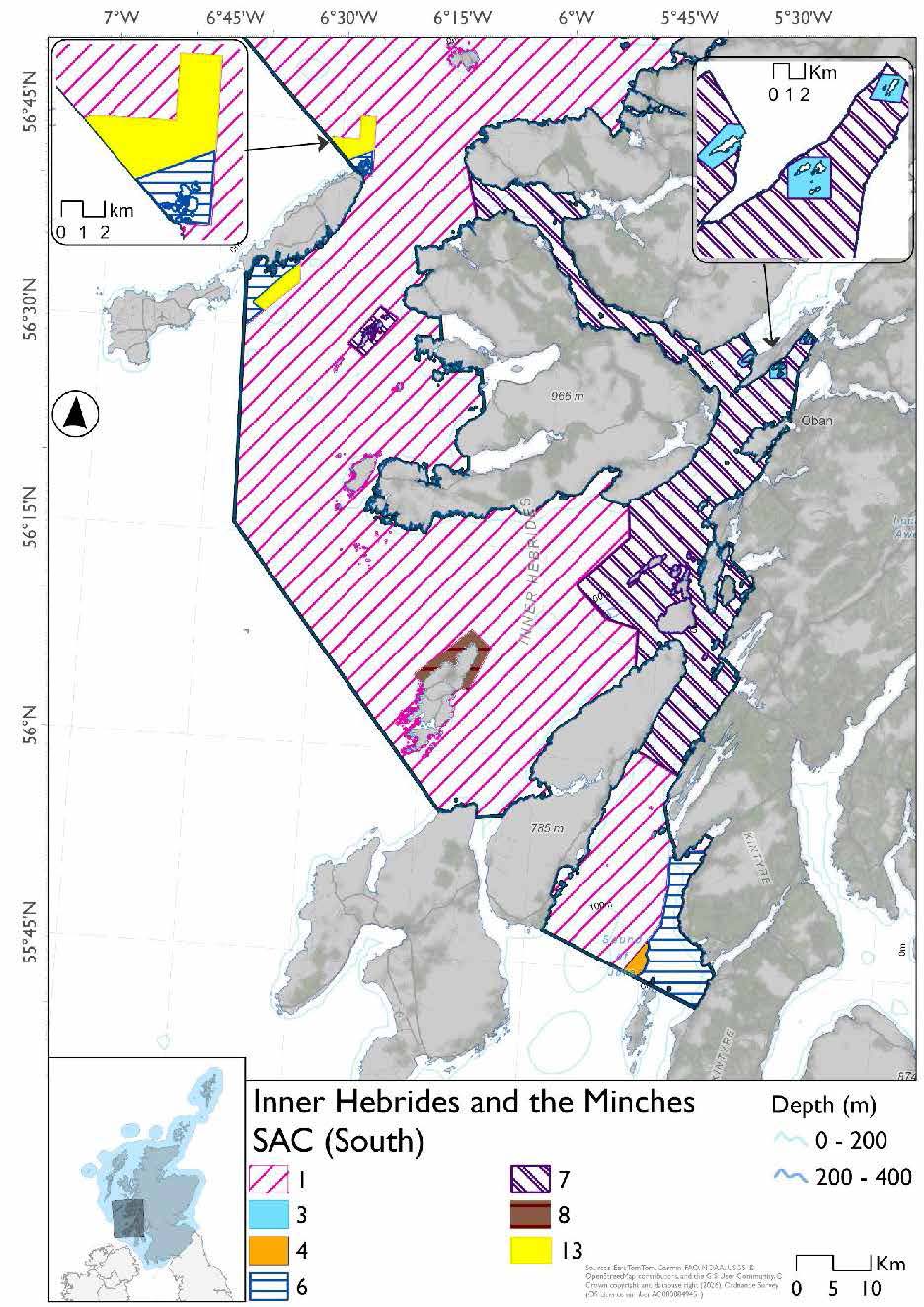
This SAC has two maps for Option 1 due to its size. The proposed management measures for Inner Hebrides and the Minches SAC are as follows:
Option One*
- Set nets (not including fyke nets) prohibited (Hatching 1)
- Set nets (not including fyke nets and tangle nets) prohibited (Hatching 2)
- Set nets (including fyke nets) and hydraulic dredge already prohibited and pelagic seine (including ring-nets) prohibited in overlapping areas with Eileanan agus Sgeiran Lios mor SAC from measures already in place from Loch Sunart to Sound of Jura NCMPA (Hatching 3)
- Pelagic set nets prohibited in overlapping areas with West Coast of the Outer Hebrides and Sound of Gigha SPAs that are deeper than 60m based on presence of all species (Fill 4)
- Set nets (including fyke nets) and pelagic seine (including ring-nets) prohibited in overlapping area with the Ascrib, Isay & Dunvegan SAC (Hatching 5)
- Set nets (including fyke nets) prohibited in overlapping areas with the Small Isles NCMPA (includes part of Canna and Sanday SPA), Sound of Gigha (shallower than 60m) and Coll & Tiree (shallower than 60m) based on presence and maximum dive depths of protected features (Hatching 6)
- Set nets and hydraulic dredge already prohibited in overlapping areas with Red Rocks and Longay NCMPA, Loch Sunart to the Sound of Jura NCMPA, Treshnish Isles SAC and BUTEC range (Hatching 7)
- Set nets (including fyke nets) prohibited from February until end of August based on presence and maximum dive depth for guillemot in overlapping area with North West Colonsay and Western Cliffs SPA. (Hatching 8)
- Longlines (until technical measures come into force) prohibited, demersal set nets (including fyke nets) prohibited February till end of August and pelagic set nets prohibited February till mid-October in overlapping portion of Rum SPA deeper than 32.7m but shallower than 177m based on maximum dive depth of guillemot and presence of guillemot and Manx shearwater. (Hatching 9)
- Longlines (until technical measures come into force) prohibited and set nets (including fyke nets) prohibited February till mid-October in overlapping portion of the Rum SPA shallower than 32.7m, based on mean dive depth (maximum unknown) and presence of Manx shearwater. (Fill 10)
- Longlines (until technical measures come into force) and set nets (including fyke nets) prohibited in overlapping areas with Rum and Shiant Isles SPAs (Hatching 11)
- Longlines (until technical measures come into force) prohibited, demersal set nets (including fyke nets) prohibited from February till end of August and pelagic set nets prohibited in areas deeper than 64.5m based on presence of guillemot and shag in overlapping area with Shiant Isles SPA.(Fill 12)
- Demersal set nets prohibited from April till the end of October and pelagic set nets prohibited in overlapping areas with Coll and Tiree SPA that are deeper than 60m, based on presence of eider (Fill 13)
- Full site closure to hydraulic dredge
Figure 117. Map of measures proposed under option 1 (North)
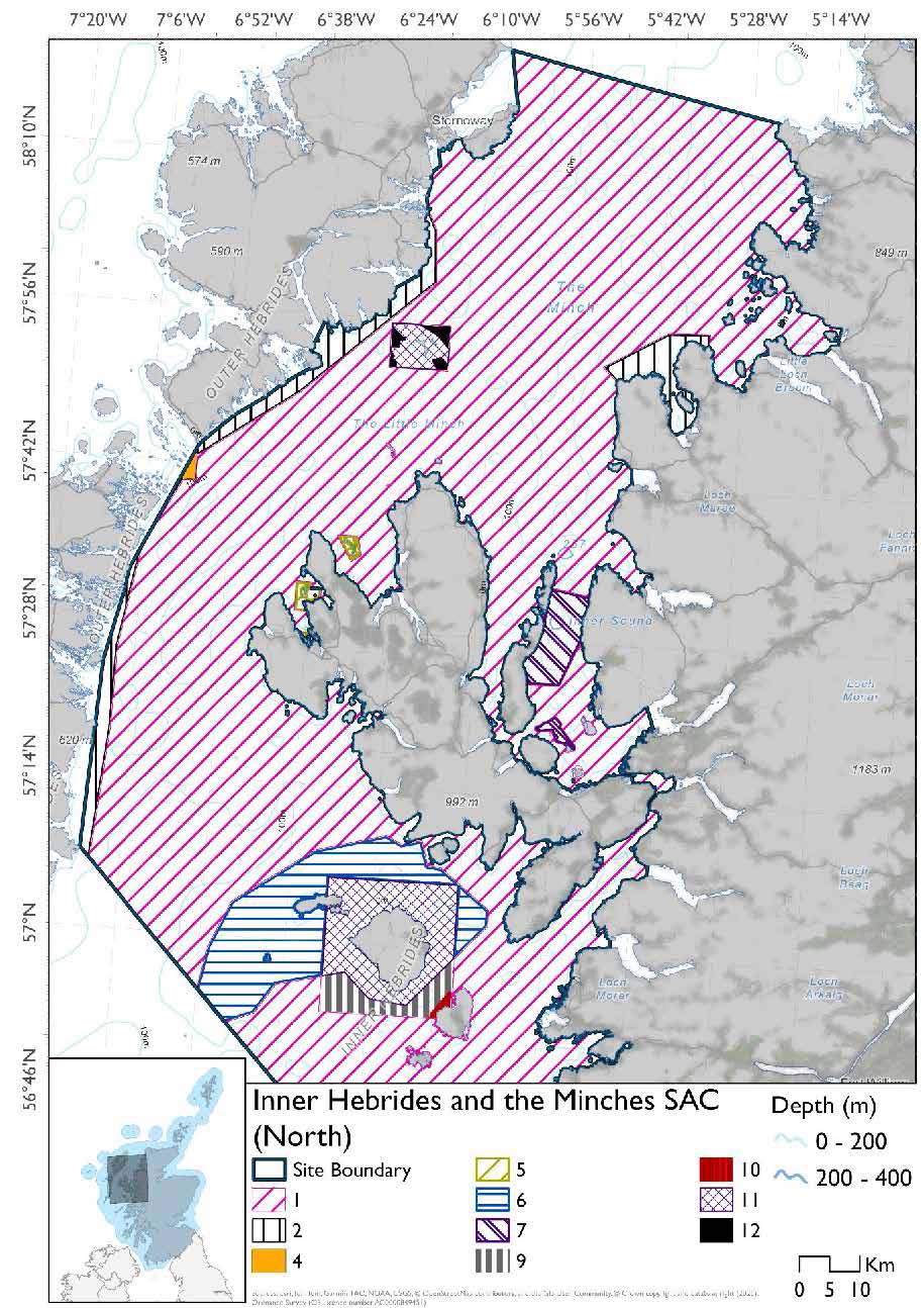
Figure 118. Map of measures proposed under option 1 (South)
*This site will have other demersal mobile measures that may apply from the overlapping portions with the proposed PMF management areas, NCMPAs and SACs that aren’t shown on the map for this option.
- Small Isles NCMPA and Sound of Arisaig (including marine component of Loch Moidart and Loch Shiel Woods) SACs have zoned measures for demersal trawl and seine, beam trawl, hydraulic dredge and mechanical dredge. Measures would depend on where overlap occurs
- Shiant East Bank NCMPA would prohibit all demersal mobile gear in the overlapping area
- The proposed PMF management areas would prohibit all demersal mobile gear from the entire area that overlaps (see section below for overlapping areas)
Please check the Option 1 or single management overlapping site and area maps to see proposed demersal mobile measures under Option 1.
Option Two*
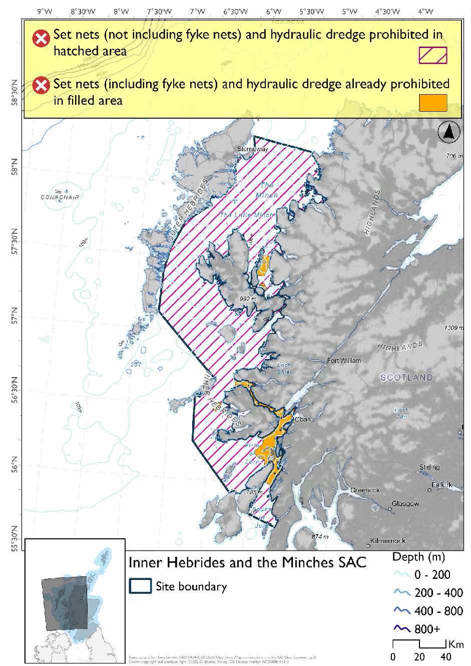
- Full site closure to set nets (not including fyke nets) and hydraulic dredge
Figure 119. Map of measures proposed under option 2
*The measures for Option 2 proposals only come from gear types prohibited in non-overlapping areas. Overlapping restrictions may still apply from overlapping sites or areas dependent on the decisions taken for that site or area.
Overlapping sites and areas included in this consultation
This SAC overlaps with these MPAs:
- North-East Lewis, Small Isles and Shiant East Bank NCMPAs
- Ascrib, Isay & Dunvegan, Eileanan agus Sgeiran Lios mór and Sound of Arisaig (including marine component of Loch Moidart and Loch Shiel Woods SACs
- North Colonsay and Western Cliffs, Sound of Gigha, Canna and Sanday SPA, Rum, Coll & Tiree, Shiant Isles and West Coast of the Outer Hebrides SPAs
This SAC overlaps with these proposed PMF management areas:
- Ascrib Islands (Skye)
- Rubha Chuaig (Inner Sound)
- East Loch Tarbert and Scalpay (Harris)
- East of BUTEC (Inner Sound)
- Eigg, South-East
- Little Minch
- Loch a' Chumhainn (Mull)
- Loch Ainort and Caolas Scalpay (Skye)
- Loch Bay (Skye)
- Loch Bracadale (Skye)
- Loch Craignish (Argyll)
- Loch nan Ceall (Arisaig)
- Loch nan Uamh (Arisaig)
- Loch Nevis (Knoydart)
- Loch Scavaig (Skye)
- Loch Sligachan (Skye)
- Lochs Eishort and Slapin (Skye)
- Muck and Godag
- North of Crowlin Islands and Eilean na Ba (Inner Sound)
- Pabay, North (Inner Sound)
- Pabay, South-West (Inner Sound)
- Port Erradale (Gairloch)
- Red Point (Torridon)
- Sandaig Bay
- Scalpay, North (Inner Sound)
- Sound of Iona (Mull)
- Sound of Islay (Islay)
- South of Muck and Bo Fascadale
- Ulva and Loch na Keal (Mull)
- West Loch Tarbert (Kintyre)
Rationale for developed measures
The basis for the proposed fisheries management measures for each site has been determined by the management advice for fishing activities provided by NatureScot, which can be found on their website or Sitelink as signposted throughout this document. The Fisheries Assessment for each site assesses the impacts from existing fishing activities on the protected features using the tests from the legislation relevant for the type of MPA being considered. The assessment outlines how the proposed measures address any impacts identified that could hinder the conservation objectives of the MPA.
17.3.7 Other fisheries management measures currently applying to this site
There are already management measures in place. An effort has been made to identify existing measures which affect each individual site or area, however the list may not be exhaustive. These measures are outlined below, and the proposals for further management being consulted on now are in addition to these existing measures:
- Fishing for sandeel is prohibited within the Scottish zone, which is defined as the sea adjacent to Scotland up to the 200 nautical miles limit
- North western waters: United Kingdom waters of ICES divisions 5b, 6a,7ahj, 200-600m depth Bottom set gillnet, entangling net and trammel net at any position where the charted depth is greater than 200 m in parts of the site
Enard Bay
- Trawling and dredging prohibited across part of the site from 01 October till 31 March. Suction dredges prohibited across part of the site
Wester Ross MPA
- Demersal trawl over 500kw or any beam trawl prohibited across part of the site Demersal trawl and dredge prohibited across part of the site
North Rona
- Creels prohibited in part of the site
Loch Gairloch
- Fishing for sea fish with mobile or active gear prohibited in part of the site
Loch Torridon and Northern Inner Sound
- Trawls and suction dredges prohibited all year round in part of the site
- Fishing for sea fish with mobile or active gear prohibited from 01 October till 31 March each year in part of the site
Inner Sound
- Bottom set gillnet, entangling net and trammel net at any position where the charted depth is greater than 200 m in part of the site
BUTEC range, Inner Sound
- All fishing methods prohibited in part of the site (inner area of Butec)
- Fishing methods mobile gear and gillnets prohibited in part of the site (outer area of Butec)
Southern Inner Sound
- Dredge, beam trawl, demersal trawl or demersal seine net is prohibited in part of the site all year
- Suction dredges prohibited all year across part of the site
- 01 October until 31st March fishing for sea fish with a dredge, beam trawl, demersal trawl or demersal seine net is prohibited across part of the site
- 01 April until 30 September fishing for sea fish with a dredge, beam trawl, demersal trawl or demersal seine net is prohibited across part of the site. Does not apply to either a fishing boat with a single beam trawl or demersal seine; or from a fishing boat with a registered length less than 12 metres with a single demersal trawl [or] a mechanical dredge.
- Fishing for horse mussels is prohibited in part of the site
Red Rocks and Longay MPA, Inner Sound
- Any passive fishing gear, demersal fishing gear or use of a rod and line or handline except the removal of king scallops and queen scallops by hand
Loch Maddy to Stuley Protected Area
- Suction dredge prohibited all year in part of the site
- Fishing for any species of sea fish except king scallops and queen scallops with a trawl, Danish seine or similar net, purse seine, ring net or dredge between 1st March and 31st October each year (both dates inclusive) in part of the site
- All methods of fishing for king scallops or queen scallops between 1st March and 30th April each year (both dates inclusive) in part of the site
- All methods of fishing for king scallops or queen scallops between 25th August and 31st October each year (both dates inclusive) in part of the site
Loch Sunart Protected Area
- Fishing for sea fish with a dredge, set net (gillnet), long line, line, beam trawl, demersal trawl, demersal seine net, creel or parlour creel is prohibited in part of the site
- Fishing for horse mussels is prohibited in part of the site
Loch Sunart to the Sound of Jura Protected Area
- Suction dredges, gillnets and hooks are prohibited in part of the site, year round
- All fishing gear is prohibited apart from the use of a demersal trawl (other than a beam trawl) but without the attachment and use of tickler chains, year round, in part of the site
Mull Box
- The vessel to which this licence relates is prohibited, at all times, from fishing with a trawl or dredge (including a suction dredge) is prohibited in part of the site
Treshnish Isles Protected Area
- Fishing for sea fish with a dredge, beam trawl, demersal trawl, demersal seine net or set net is prohibited in part of the site
Loch Sween Protected Area
- Fishing by hand or with a dredge, beam trawl, demersal seine net or demersal trawl is prohibited in part of the site year round
- In the overlap with the excepted area hand gathering is permitted
- In the overlap with the excepted area demersal trawling by fishing vessels of 75 gross tonnes or less is permitted
- In the overlap with the excepted area mechanical dredging by fishing vessels of 75 gross tonnes or less is permitted between 0700 and 2100, Monday to Friday only
Stuley Island to Barra Head and Gurney Point
- Fishing with mobile/active gear prohibited from 1 March to 31 October each year in part of the site. This includes trawls, Danish seines or similar nets, purse seines, ring nets and dredges (not including suction dredges)
- Fishing for scallops permitted between 01 May and 24th August in part of the site
- Suction dredging is prohibited all year in part of the site
Other conservation measures can be und in section 7 of the CMA.
17.4 Sound of Arisaig (Loch Ailort to Loch Ceann Traigh) SAC (including marine component of Loch Moidart and Loch Shiel Woods SAC)
17.4.1 Description and background
The Sound of Arisaig SAC lies on the west coast of Scotland, between Loch Ailort, Loch Moidart and Loch Ceann Traigh. It covers around 4,500 hectares and is designated for its subtidal sandbanks.
The site contains an extensive mix of sandbanks and other seabed habitats, forming a varied mosaic. Sheltered areas are dominated by muddy sands, while more exposed areas have coarser sediments. This variation creates a range of conditions that support diverse bottom‑dwelling communities and is central to the site’s ecological importance.
These habitats support features such as maerl beds and seagrass beds where conditions allow. Both are important parts of Scotland’s subtidal ecosystems, supporting high biodiversity and playing key roles in food webs and invertebrate communities.
The Loch Moidart and Loch Shiel Woods SAC is mainly designated for terrestrial habitats, especially Atlantic oak woodland, but it also includes a marine component within Loch Moidart.
This marine area is designated for intertidal mudflats and sandflats that are exposed at low tide. These habitats form large, relatively undisturbed sediment flats that are typical of north‑west Scotland.
The flats consist of mud, muddy sand and clean sand, supporting a wide range of invertebrates such as worms, shellfish and crustaceans typical of soft‑sediment habitats. Loch Moidart itself is a shallow, sheltered sea loch where large areas of seabed are exposed at low tide. Tides and freshwater inputs create changing conditions that influence salinity and sediment.
The SAC also supports specialised habitats in very sheltered conditions, including a distinctive free‑living form of egg wrack. This grows on mixed seabeds, such as cobbles over mud and sand, often in areas with variable salinity. These habitats create complex structures that support a range of species, including invertebrates and algae that grow on other plants.
Loch Moidart is included in the SAC to protect this representative intertidal system and its associated species. Its marine component also supports links between land and sea, including nutrient exchange, food webs and habitat continuity.
Further information, including Conservation and Management Advice (CMA) can be found on Sitelink by searching for each site individually.
Further information on MPAs, the wider network and protected areas management is available at Scottish Government MPA policy page.
17.4.2 Protected features
Sound of Arisaig SAC has been designated to protect:
- Subtidal sandbanks
Marine component of the Loch Moidart and Loch Sheil Woods SAC has been designated to protect:
- Intertidal mudflats and sandflats
17.4.3 Conservation Objectives
The subtidal sandbanks habitat is in favourable condition at Sound of Arisaig SAC and therefore the Conservation Objectives seek to maintain this condition.
The intertidal mudflats and sandflats habitat is in favourable condition at Loch Moidart and Loch Sheil Woods SAC and therefore the Conservation Objectives seek to maintain this condition.
Additional details, including the Conservation Objectives, are provided in the Conservation and Management Advice documents produced for these SACs and can be found on Sitelink by searching for the sites individually.
17.4.4 Pressure from fishing activity
Fishing activities exert pressure on intertidal mudflats, sandflats, subtidal sandbanks, and their sub-features, primarily through physical disturbance and habitat degradation. Bottom-towed fishing gear such as dredges and trawls disrupt sediment structure, crush or remove infaunal species, and reduce habitat complexity, leading to biodiversity loss and impaired ecological function. These impacts are especially severe in low-energy environments where fine sediments settle and recovery is slow.
Sediment resuspension from fishing gear increases turbidity and reduces water clarity, affecting photosynthetic organisms and filter feeders. Discarded catch and gear residues can cause organic enrichment, altering nutrient balances and oxygen levels, potentially resulting in hypoxic conditions. Overfishing and bycatch also reduce prey availability for birds and fish that depend on these habitats for feeding.
Maerl beds, a sub-feature of subtidal sandbanks, are extremely fragile and suffer permanent damage from crushing, burial, and sedimentation, which block essential water flow and nutrient exchange. Seagrass beds, also a sub-feature of subtidal sandbanks, are equally sensitive, with physical disturbance and reduced water quality impairing growth and photosynthesis. Both habitats are also sensitive to the introduction of invasive species, which could be spread via fishing vessels and gear. These habitats have low resilience and recover slowly, making even moderate fishing activity a long-term threat.
Additional details are provided in the Conservation and Management Advice document produced for these SACs (section 6) and can be found by searching for each site individually on Sitelink.
Other resources include:
- The Feature Activity Sensitivity Tool (FeAST) which allows users to investigate the sensitivity of marine features (habitats, species, geology and landforms) in Scotland's seas, to pressures arising from human activities;
- Fisheries Guidance Notes which provide summaries of evidence on the interaction between fishing gears and specific habitats and species.
17.4.5 Fisheries management advice relevant to proposed fisheries management measures
NatureScot provides risk-based advice to help manage activities that may impact protected features and their Conservation Objectives. See section 2.3 for more detail. The CMA documents, which can be found by searching for each site individually, on Sitelink, also sets out the full fisheries management advice that has been summarised below for the management measures proposed:
Demersal mobile/active gear and hydraulic (diver or vessel)
Remove or avoid pressures is recommended where maerl beds and seagrass beds are present.
Reduce or limit pressures is recommended in all other areas.
Hydraulic (diver or vessel)
Remove or avoid pressures is recommended where maerl beds and seagrass beds are present.
Reduce or limit pressures is recommended in all other areas.
17.4.6 Proposed fisheries management measures
The proposed management measures for Sound of Arisaig SAC (including marine component of Loch Moidart and Loch Shiel Woods SAC) are as follows:
Option One*
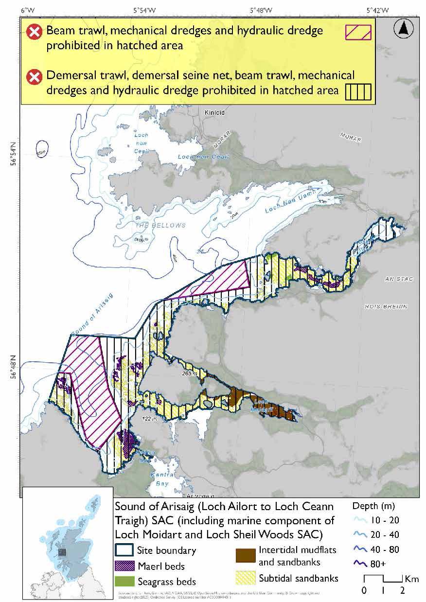
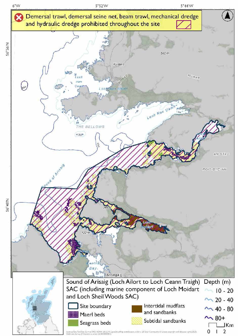
- Demersal trawls or seines prohibited in part of site
- Full site closure to beam trawls, mechanical dredge and hydraulic dredge
Figure 120. Map of measures proposed under option 1
*This site will have other measures that may apply from the overlapping portions with the Inner Hebrides and the Minches SAC that aren’t shown on the map for this option.
- Inner Hebrides and the Minches would prohibit set nets (not including fyke nets) in overlapping areas.
Please check the Option 1 overlapping site maps to see proposed demersal mobile measures under Option 1.
Option Two*
- Full site closure to demersal trawl and seine, beam trawl, mechanical dredge and hydraulic dredge
Figure 121. Map of measures proposed under option 2
*The measures for Option 2 proposals only come from gear types prohibited in non-overlapping areas. Overlapping restrictions may still apply from overlapping sites or areas dependent on the decisions taken for that site or area.
Overlapping site included in this consultation
This SAC overlaps with the Inner Hebrides and the Minches SAC.
Rationale for measures developed
The basis for the proposed fisheries management measures for each site has been determined by the management advice for fishing activities provided by NatureScot, which can be found on their website or Sitelink as signposted throughout this document. The Fisheries Assessment for each site assesses the impacts from existing fishing activities on the protected features using the tests from the legislation relevant for the type of MPA being considered. The assessment outlines how the proposed measures address any impacts identified that could hinder the conservation objectives of the MPA.
17.4.7 Other fisheries management measures currently applying to this site
There are already management measures in place. An effort has been made to identify existing measures which affect each individual site or area, however the list may not be exhaustive. These measures are outlined below, and the proposals for further management being consulted on now are in addition to these existing measures:
- Fishing for sandeel is prohibited within the Scottish zone, which is defined as the sea adjacent to Scotland up to the 200 nautical miles limit
Other conservation measures can be found in section 7 of each CMA document found by searching each site individually on Sitelink
17.5 Canna and Sanday SPA
17.5.1 Description and background
The Canna and Sanday SPA is located in the Inner Hebrides, northwest of the Isle of Rum, and encompasses the islands of Canna and Sanday along with their surrounding islets and marine waters. The site is internationally recognised for its importance to seabird conservation and is classified under the EU Birds Directive to protect a range of breeding seabird species and their supporting habitats.
The SPA supports a diverse mosaic of terrestrial and marine habitats, including maritime heathland, calcareous grasslands, cliff systems, and productive inshore waters. These habitats provide essential nesting, breeding, and foraging conditions for the SPA’s protected features, which include guillemot, herring gull, kittiwake, puffin and shag. The surrounding marine environment is a critical component of the site, supporting key prey resources such as sandeels and other forage fish that underpin breeding success and adult survival of these species.
Further information, including Conservation and Management Advice (CMA) can be found on Sitelink.
Further information on MPAs, the wider network and protected areas management is available at Scottish Government MPA policy page.
17.5.2 Protected features
The Canna and Sanday SPA has been designated to protect five species of breeding seabirds:
- Guillemot;
- Herring gull;
- Kittiwake;
- Puffin; and
- Shag
The protected features of the Canna and Sanday SPA are protected within the SPA throughout the year, irrespective of the season for which they qualified as a protected feature.
17.5.3 Conservation Objectives
The following protected features are in favourable condition at Canna and Sanday SPA: puffin and kittiwake. Therefore, the Conservation Objectives seek to maintain this condition.
The following protected features are in unfavourable condition at Canna and Sanday SPA: guillemot, shag and herring gull. Therefore, the Conservation Objectives seek to restore this condition.
Additional details, including the Conservation Objectives, are provided in the Conservation and Management Advice document produced for this SPA and can be found on Sitelink.
17.5.4 Pressure from fishing activity
Fishing activities exert pressures on breeding seabirds such as puffins, guillemots, kittiwakes, shags, and herring gulls, primarily through bycatch and prey depletion. All five species are sensitive to accidental entanglement in surface fishing gears, with shags also at risk from pelagic and demersal nets. These interactions can lead to injury or mortality, particularly during breeding and moulting periods.
Overfishing of key prey species like sandeels reduces food availability, undermining breeding success and adult survival across all species.
Disturbance from fishing vessels can disrupt foraging and nesting, particularly in guillemots and shags, while displacement and collision risks affect kittiwakes, shags, and gulls. These combined pressures pose ongoing threats to seabird populations in marine environments.
Additional details are provided in the CMA document produced for this SPA and can be found on Sitelink.
Other resources include:
- The Feature Activity Sensitivity Tool (FeAST) which allows users to investigate the sensitivity of marine features (habitats, species, geology and landforms) in Scotland's seas, to pressures arising from human activities;
- Fisheries Guidance Notes which provide summaries of evidence on the interaction between fishing gears and specific habitats and species.
17.5.5 Fisheries management advice relevant to proposed fisheries management measures
NatureScot provides risk-based advice to help manage activities that may impact protected features and their Conservation Objectives. See section 2.3 for more detail. The CMA document also sets out the full fisheries management advice that has been summarised below for the management measures proposed:
Hydraulic gear
Remove or avoid pressures (removal of prey species and disturbance of prey-supporting habitat) associated with hydraulic fishing that has the potential to damage seabed habitat (in particular, sandeel habitat, herring spawning grounds) is recommended.
Static gear (drift nets and bottom set nets including fyke nets)
Remove or avoid pressures (entanglement) associated with the use of all static nets. Spatial exclusion of all static nets in areas identified as being important for auks and shags (as identified from habitat and dive depth preferences) is recommended.
Pelagic gear
Pelagic fishing for herring/sprat may occur within or around the SPA. It is recommended that a principal objective of the management of the fishery should be ensuring that the fishing activity does not prevent or disrupt the availability of prey species i.e. it should be considered as part of a broader ecosystem-based approach to management of this fishery.
Longlining (not including jigging)
Long-lining (pelagic and demersal) may occur within or around the SPA(s). Current understanding is that long-line fisheries are largely restricted to offshore waters. Site-specific measures for long-lining are not currently considered appropriate due to the scale of the fishery, and the wide-spread interaction with seabirds. However, there is evidence of seabird bycatch in long-line (not jigging) fisheries therefore it is recommended this requires wider seas management measures.
For the SPAs advice has also been provided on maximum dive depth and seasonality for protected features of each site and can be found in the Fishing Activity Further Advice and Evidence document. Supplementary advice can also be found on NatureScot’s website.
17.5.6 Proposed fisheries management measures
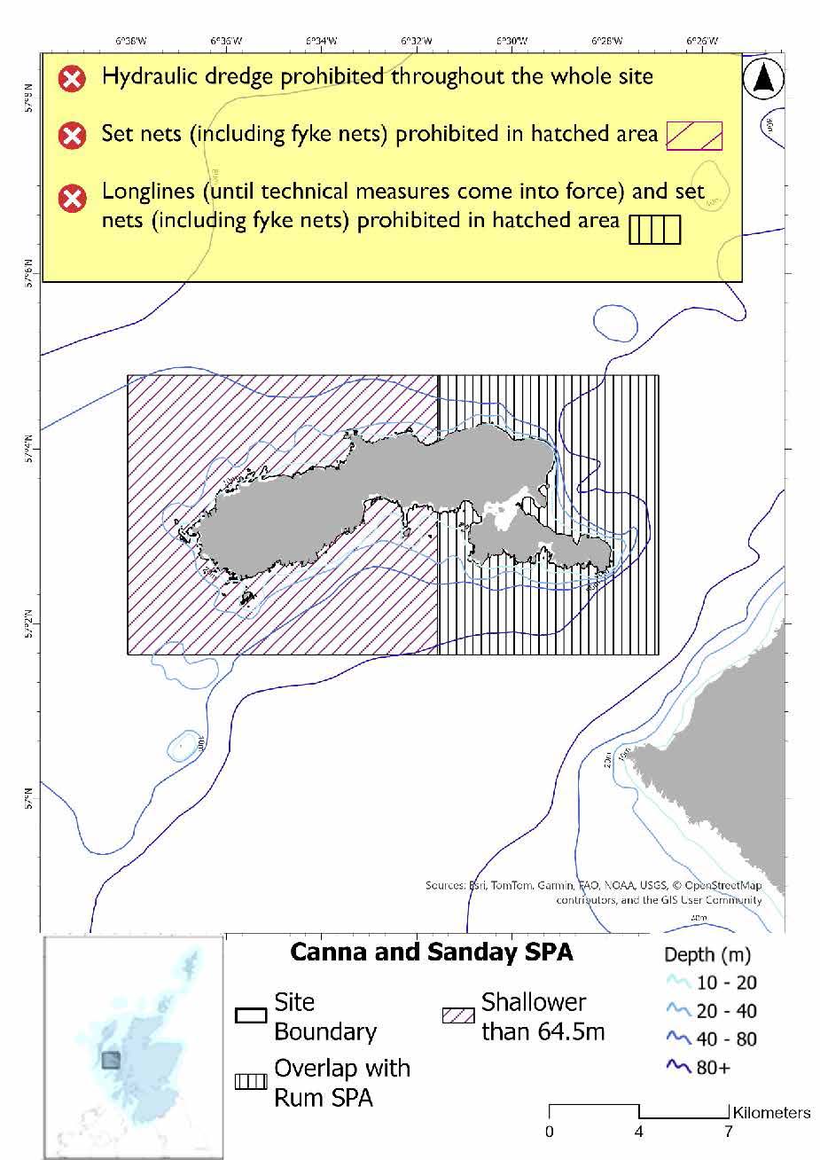
The proposed management measure for Canna and Sanday SPA is as follows:
Single Proposed Management Option*
- Full site closure to set nets (including fyke nets) and hydraulic dredge based on overlapping measures from Small Isles NCMPA
- Longlines (until technical measures come into force) prohibited in overlapping portion with the Rum SPA
Figure 122. Map of measures proposed
A full site level of protection from the specified gear has been identified as the only suitable option in enabling the achievement of the desired level of protection for the feature in question.
*This site will have other demersal mobile measures that may apply from the overlapping portions with the Small Isles NCMPA that aren’t shown on the map for this option.
- Small Isles NCMPA has zoned measures for demersal trawl, demersal seine net, beam trawl and mechanical dredge. Measures would depend on where overlap occurs.
Please check the Option 1 overlapping site map to see proposed demersal mobile measures under Option 1.
Overlapping sites included in this consultation
This SPA overlaps with the Small Isles and Sea of the Hebrides NCMPAs, Rum SPA and Inner Hebrides and the Minches SAC.
Rationale for developed measures
The basis for the proposed fisheries management measures for each site has been determined by the management advice for fishing activities provided by NatureScot, which can be found on their website or Sitelink as signposted throughout this document. The Fisheries Assessment for each site assesses the impacts from existing fishing activities on the protected features using the tests from the legislation relevant for the type of MPA being considered. The assessment outlines how the proposed measures address any impacts identified that could hinder the conservation objectives of the MPA.
17.5.7 Other fisheries management measures currently applying to this site
There are already management measures in place. An effort has been made to identify existing measures which affect each individual site or area, however the list may not be exhaustive. These measures are outlined below, and the proposals for further management being consulted on now are in addition to these existing measures:
- Fishing for sandeel is prohibited within the Scottish zone, which is defined as the sea adjacent to Scotland up to the 200 nautical miles limit
- Bottom set gillnet, entangling net and trammel net at any position where the charted depth is greater than 200 m in parts of the site
Other conservation measures can be found in section 7 of the CMA.
17.6 Handa SPA
17.6.1 Description and background
The Handa SPA is located off the northwest coast of Scotland, near Scourie in Sutherland. This rugged island, accessible by ferry from Tarbet during the summer months, is internationally recognised for its importance to breeding seabirds. The SPA was designated under the EU Birds Directive to protect significant populations of seabird species that nest on its dramatic cliffs and coastal habitats.
Handa supports a rich assemblage of breeding seabirds. The island’s steep cliffs and maritime vegetation provide ideal nesting conditions, while the surrounding waters offer abundant feeding opportunities. The SPA also includes populations of Arctic skua, a species of conservation concern due to its declining numbers across the UK.
Further information, including Conservation and Management Advice (CMA) can be found on Sitelink.
Further information on MPAs, the wider network and protected areas management is available at Scottish Government MPA policy page.
17.6.2 Protected features
The Handa Special Protection Area (SPA) has been designated to protect five species of breeding seabirds:
- Fulmar;
- Great skua;
- Guillemot;
- Kittiwake; and
- Razorbill
The protected features of the Handa SPA are protected within the SPA throughout the year, irrespective of the season for which they qualified as a protected feature.
17.6.3 Conservation Objectives
The following protected feature is in favourable condition at Handa SPA: great skua. Therefore, the Conservation Objectives seek to maintain this condition.
The following protected features are in unfavourable condition at Handa SPA: kittiwake, guillemot, fulmar and razorbill. Therefore, the Conservation Objectives seek to restore this condition.
Additional details, including the Conservation Objectives, are provided in the Conservation and Management Advice document produced for this SPA and can be found on Sitelink.
17.6.3 Pressure from fishing activity
Fishing activities exert pressures on breeding seabirds such as kittiwakes, guillemots, razorbills, great skuas, and fulmars, primarily through bycatch and prey depletion. Accidental entanglement in surface and longline gears is a major threat across all species, with great skuas particularly sensitive to longline capture. These interactions can result in injury or mortality, especially during sensitive periods like the flightless moult.
Prey depletion from overfishing and reduced fisheries discards further impacts breeding success and adult survival. All five species depend on abundant prey during the breeding season, and great skuas are further affected due to their reliance on both direct prey and kleptoparasitism (behaviour in which one animal steals food or other resources that another animal has obtained rather than finding or catching the resource itself). Together, these pressures, bycatch and prey depletion undermine seabird health and reproductive success, making fishing activity a key concern for their conservation.
Additional details are provided in the CMA document produced for this SPA and can be found on Sitelink.
Other resources include:
- The Feature Activity Sensitivity Tool (FeAST) which allows users to investigate the sensitivity of marine features (habitats, species, geology and landforms) in Scotland's seas, to pressures arising from human activities;
- Fisheries Guidance Notes which provide summaries of evidence on the interaction between fishing gears and specific habitats and species.
17.6.4 Fisheries management advice relevant to proposed fisheries management measures
NatureScot provides risk-based advice to help manage activities that may impact protected features and their Conservation Objectives. See section 2.3 for more detail. The CMA document also sets out the full fisheries management advice that has been summarised below for the management measures proposed:
Hydraulic gear
Remove or avoid pressures (removal of prey species and disturbance of prey-supporting habitat) associated with hydraulic fishing that has the potential to damage seabed habitat (in particular, sandeel habitat, herring spawning grounds) is recommended.
Static gear (drift nets and bottom set nets including fyke nets)
Remove or avoid pressures (entanglement) associated with the use of all static nets. Spatial exclusion of all static nets in areas identified as being important for auks (as identified from habitat and dive depth preferences) is recommended.
Pelagic gear
Pelagic fishing for herring/sprat may occur within or around the SPA. It is recommended that a principal objective of the management of the fishery should be ensuring that the fishing activity does not prevent or disrupt the availability of prey species i.e. it should be considered as part of a broader ecosystem-based approach to management of this fishery.
Longlining (not including jigging)
Long-lining (pelagic and demersal) may occur within or around the SPA(s). Current understanding is that long-line fisheries are largely restricted to offshore waters. Site-specific measures for long-lining are not currently considered appropriate due to the scale of the fishery, and the wide-spread interaction with seabirds. However, there is evidence of seabird bycatch in long-line (not jigging) fisheries therefore it is recommended this requires wider seas management measures.
For the SPAs advice has also been provided on maximum dive depth and seasonality for protected features of each site and can be found in the Fishing Activity Further Advice and Evidence document. Supplementary advice can also be found on NatureScot’s website.
17.6.5 Proposed fisheries management measures
The proposed management measures for Handa SPA are as follows:
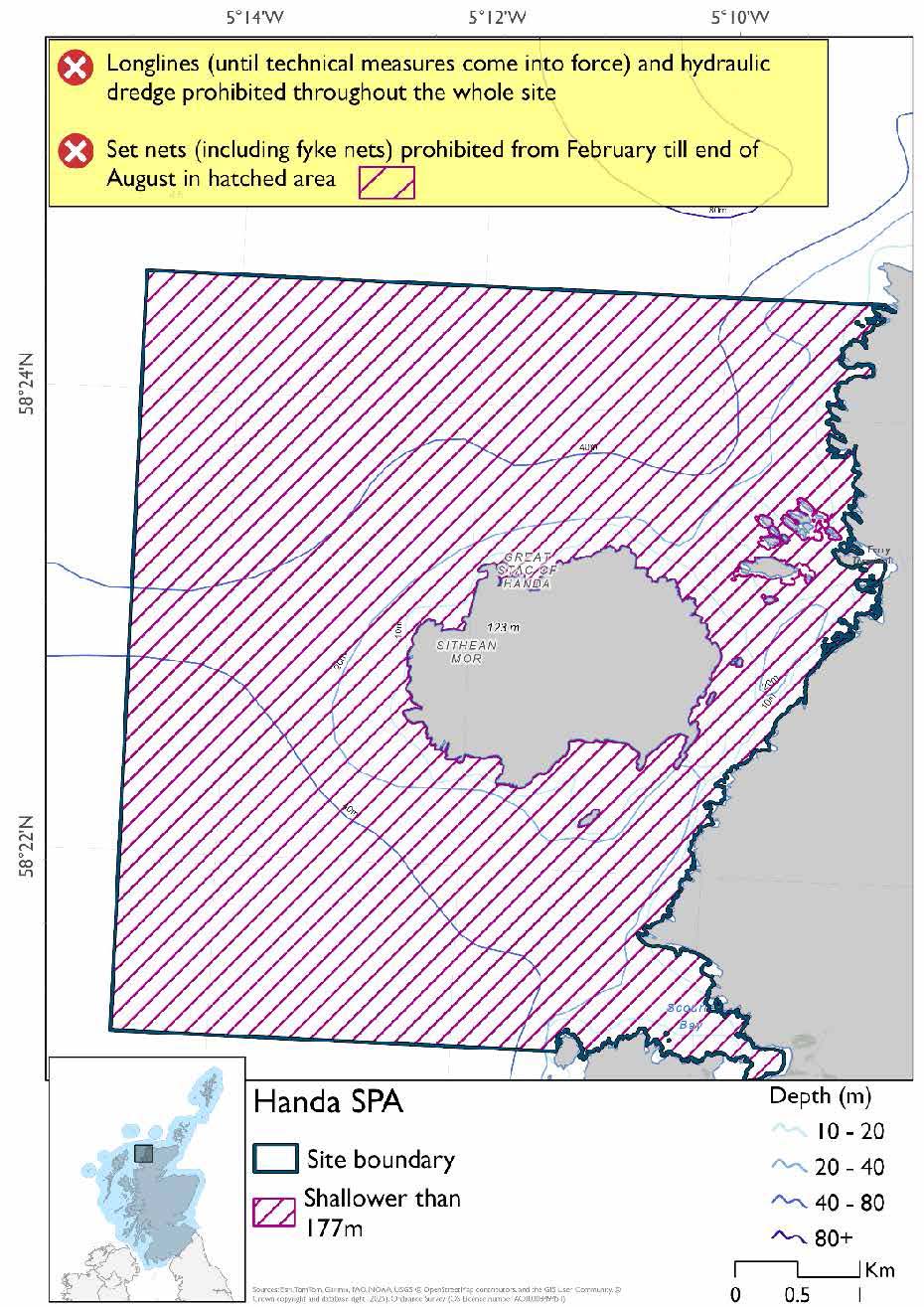
Option One*
- Set nets (including fyke nets) prohibited from February till end of August in areas down to 177m based on presence and maximum dive depth for guillemot
- Full site closure to longlines (until technical measures come into force) and hydraulic dredge
Figure 123. Map of measures proposed under option 1
*This site will have other demersal mobile measures that may apply from the overlapping portions with the proposed PMF management that aren’t shown on the map for this option.
- The proposed PMF management areas would prohibit all demersal mobile gear from the entire area that overlaps. (see section below for overlapping areas)
Please check the Option 1 or single management overlapping area map to see proposed demersal mobile measures under Option 1.
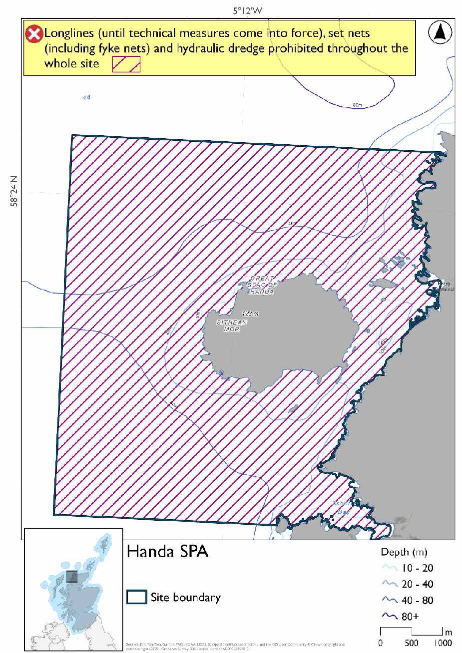
Option Two*
- Full site closure to longlines (until technical measures come into force), set nets (including fyke nets) and hydraulic dredge
Figure 124. Map of measures proposed under option 2
*The measures for Option 2 proposals only come from gear types prohibited in non-overlapping areas. Overlapping restrictions may still apply from overlapping sites or areas dependent on the decisions taken for that site or area.
Overlapping area included in this consultation
This SPA overlaps with the Handa (Durness) proposed PMF management area.
Rationale for developed measures
The basis for the proposed fisheries management measures for each site has been determined by the management advice for fishing activities provided by NatureScot, which can be found on their website or Sitelink as signposted throughout this document. The Fisheries Assessment for each site assesses the impacts from existing fishing activities on the protected features using the tests from the legislation relevant for the type of MPA being considered. The assessment outlines how the proposed measures address any impacts identified that could hinder the conservation objectives of the MPA.
17.6.6 Other fisheries management measures currently applying to this site
There are already management measures in place. An effort has been made to identify existing measures which affect each individual site or area, however the list may not be exhaustive. These measures are outlined below, and the proposals for further management being consulted on now are in addition to these existing measures:
- Fishing for sandeel is prohibited within the Scottish zone, which is defined as the sea adjacent to Scotland up to the 200 nautical miles limit
- Bottom set gillnet, entangling net and trammel net at any position where the charted depth is greater than 200 m in parts of the site.
Other conservation measures can be found in section 7 of the CMA.
17.7 Rum SPA
17.7.1 Description and background
The Rum SPA is located in the Inner Hebrides off Scotland’s west coast and encompasses the island of Rum along with surrounding marine waters, including parts of the Sound of Rum and the Sound of Canna. Covering an area of approximately 467 square km, the site supports internationally significant populations of seabirds and coastal bird species.
Rum is renowned for its dramatic landscapes, shaped by glaciation, and features steep cliffs, sandy bays, and raised beaches. These varied habitats provide ideal nesting and foraging conditions for a range of bird species. The SPA is particularly notable for its population of red-throated divers, a species listed in Annex I of the Birds Directive. These birds breed on freshwater lochs within the island’s blanket bog and moorland, but rely heavily on nearby inshore marine waters for foraging. During the breeding season, they typically forage within 9 km of their nest sites, diving in shallow coastal waters less than 10m deep.
In 2010, Rum supported around 13 breeding pairs of red-throated divers, representing approximately 1% of the Great Britain population. Additional pairs were recorded in surrounding areas, forming one of the largest concentrations of this species in the Inner Hebrides. The surrounding marine environment, with its mix of mud and sand sediments and dynamic tidal currents, plays a crucial role in supporting the birds’ feeding behaviour and overall breeding success.
Further information, including Conservation and Management Advice (CMA) can be found on Sitelink.
Further information on MPAs, the wider network and protected areas management is available at Scottish Government MPA policy page.
17.7.2 Protected features
The Rum SPA has been designated to protect:
- Golden eagle
- Guillemot;
- Kittiwake;
- Manx shearwater; and
- Red-throated diver;
Golden eagle is not discussed further as they are not a protected feature for which fisheries management measures are required.
The protected features of the Rum SPA are protected within the SPA throughout the year, irrespective of the season for which they qualified as a protected feature.
17.7.3 Conservation Objectives
The following protected features are in favourable condition at Rum SPA: Manx shearwater and red-throated diver. Therefore, the Conservation Objectives seek to maintain this condition.
The following protected features are in unfavourable condition at Rum SPA: kittiwake guillemot. Therefore, the Conservation Objectives seek to restore this condition.
Additional details, including the Conservation Objectives, are provided in the Conservation and Management Advice document produced for this SPA and can be found on Sitelink.
17.7.4 Pressure from fishing activity
Fishing activities exert significant pressures on several breeding seabird species, primarily through bycatch and prey depletion. Red-throated divers, guillemots, kittiwakes, and Manx shearwaters are all sensitive to incidental bycatch in various fishing gears, including surface nets, longlines, and gillnets. Manx shearwaters are particularly sensitive, with high susceptibility across multiple gear types.
Prey depletion caused by overfishing affects all four species, reducing food availability and impacting breeding success and population health. Guillemots and kittiwakes, which rely heavily on forage fish like sandeels, are especially affected. Additionally, increased turbidity from fishing operations can impair foraging efficiency for diving species such as guillemots and red-throated divers. These pressures, entanglement and reduced prey, pose ongoing risks to seabird populations, particularly during vulnerable life stages like breeding and moulting.
Additional details are provided in the CMA document produced for this SPA and can be found on Sitelink.
Other resources include:
- The Feature Activity Sensitivity Tool (FeAST) which allows users to investigate the sensitivity of marine features (habitats, species, geology and landforms) in Scotland's seas, to pressures arising from human activities;
- Fisheries Guidance Notes which provide summaries of evidence on the interaction between fishing gears and specific habitats and species.
17.7.5 Fisheries management advice relevant to proposed fisheries management measures
NatureScot provides risk-based advice to help manage activities that may impact protected features and their Conservation Objectives. See section 2.3 for more detail. The CMA document also sets out the full fisheries management advice that has been summarised below for the management measures proposed:
Hydraulic gear
Remove or avoid pressures (removal of prey species and disturbance of prey-supporting habitat) associated with hydraulic fishing that has the potential to damage seabed habitat (in particular, sandeel habitat, herring spawning grounds) is recommended.
Static gear (drift nets and bottom set nets including fyke nets)
Remove or avoid pressures (entanglement) associated with the use of all static nets. Spatial exclusion of all static nets in areas identified as being important for guillemot and red-throated diver (as identified from habitat and dive depth preferences) is recommended.
Pelagic gear
Pelagic fishing for herring/sprat may occur within or around the SPA. It is recommended that a principal objective of the management of the fishery should be ensuring that the fishing activity does not prevent or disrupt the availability of prey species for red-throated divers and the seabird protected features, i.e. it should be considered as part of a broader ecosystem-based approach to management of this fishery.
Longlining (not including jigging)
Long-lining (pelagic and demersal) may occur within or around the SPA(s). Current understanding is that long-line fisheries are largely restricted to offshore waters. Site-specific measures for long-lining are not currently considered appropriate due to the scale of the fishery, and the wide-spread interaction with seabirds. However, there is evidence of seabird bycatch in long-line (not jigging) fisheries therefore it is recommended this requires wider seas management measures.
For the SPAs advice has also been provided on maximum dive depth and seasonality for protected features of each site and can be found in the Fishing Activity Further Advice and Evidence document. Supplementary advice can also be found on NatureScot’s website.
17.7.6 Proposed fisheries management measures
NatureScot also provided amalgamated season advice for this site but individual seasonality for species has been used to develop consultation options.
The proposed management measures for Rum SPA are as follows:
Option One*
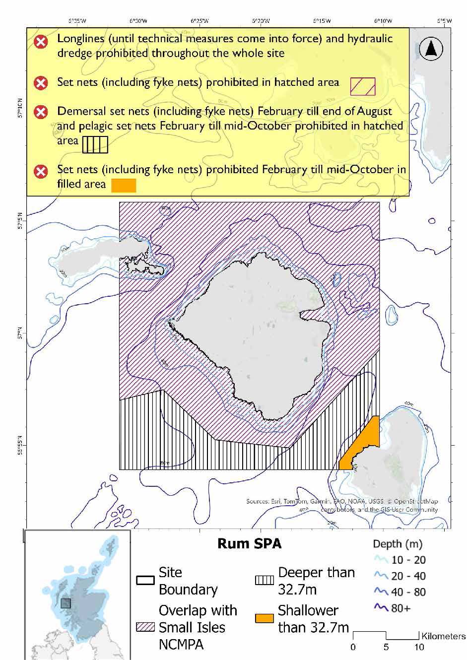
- Set nets (including fyke nets) prohibited February till mid-October in areas shallower than 32.7m based on presence and mean dive depth for Manx shearwater, maximum dive depth unknown
- Demersal set nets (including fyke nets) prohibited February till end of August and pelagic set nets prohibited February till mid-October in areas deeper than 32.7m based on presence of guillemot and Manx shearwater
- Set nets (including fyke nets) prohibited in area that overlaps with the Small Isles NCMPA
- Full site closure to longlines (until technical measures come into force) and hydraulic dredge
Figure 125. Map of measures proposed under option 1
*This site will have other demersal mobile measures that may apply from the overlapping portions with the Small Isles NCMPA that aren’t shown on the map for this option.
- Small Isles NCMPA has zoned measures for demersal trawl, demersal seine net, beam trawl and mechanical dredge. Measures would depend on where overlap occurs.
Please check the Option 1 overlapping site map to see proposed demersal mobile measures under Option 1.
Option Two*
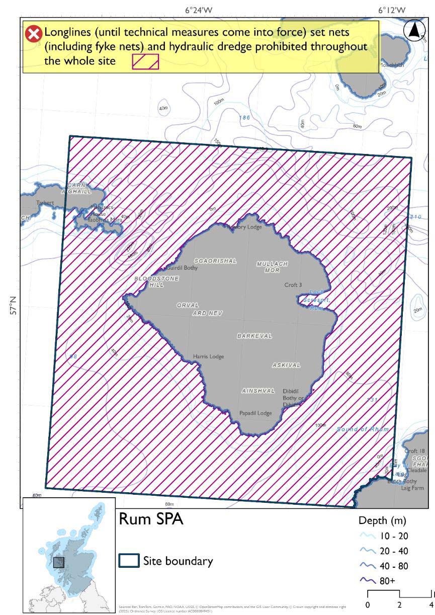
- Full site closure to longlines (until technical measures come into force), set nets (including fyke nets), and hydraulic dredge
Figure 126. Map of measures proposed under option 2
*The measures for Option 2 proposals only come from gear types prohibited in non-overlapping areas. Overlapping restrictions may still apply from overlapping sites or areas dependent on the decisions taken for that site or area.
Overlapping sites included in this consultation
This SPA overlaps with Canna & Sanday SPA, Small Isles NCMPA, Sea of the Hebrides NCMPA and Inner Hebrides and the Minches SAC.
Rationale for developed measures
The basis for the proposed fisheries management measures for each site has been determined by the management advice for fishing activities provided by NatureScot, which can be found on their website or Sitelink as signposted throughout this document. The Fisheries Assessment for each site assesses the impacts from existing fishing activities on the protected features using the tests from the legislation relevant for the type of MPA being considered. The assessment outlines how the proposed measures address any impacts identified that could hinder the conservation objectives of the MPA.
17.7.7 Other fisheries management measures currently applying to this site
There are already management measures in place. An effort has been made to identify existing measures which affect each individual site or area, however the list may not be exhaustive. These measures are outlined below, and the proposals for further management being consulted on now are in addition to these existing measures:
- Fishing for sandeel is prohibited within the Scottish zone, which is defined as the sea adjacent to Scotland up to the 200 nautical miles limit
- Bottom set gillnet, entangling net and trammel net at any position where the charted depth is greater than 200 m in parts of the site.
Other conservation measures can be found in section 7 of the CMA.
Contact
Email: marine_biodiversity@gov.scot