
Fisheries Management Measures within Scottish Inshore Marine Protected Areas (MPAs) and Proposed Priority Marine Feature (PMF) Management Areas - Site and Area Proposal Document
This document describes the process, justification and evidence used to develop site and area specific fisheries management measures. It outlines key information for each site and area including their features, and risks of potential pressures.

8. Sites in the Clyde Marine Region
8.1 Clyde Sea Sill NCMPA
8.1.1 Description and background
Clyde Sea NCMPA The Clyde Sea Sill MPA extends from the Mull of Kintyre to Corsewall Point on the Rhins of Galloway and is characterised by a prominent seabed sill where the North Channel meets the Firth of Clyde. At this point, cooler, more saline waters from the North Channel mix with warmer, less saline Clyde waters, creating persistent thermal fronts. This dynamic physical environment supports a range of important marine features, including circalittoral and offshore sand and coarse sediment communities, as well as broader seabed geomorphology characteristic of the Scottish shelf. The area also provides important foraging habitat for species such as black guillemot, which feed close to their nesting sites on nearby islands.
Further information, including Conservation and Management Advice (CMA) can be found on Sitelink .
Further information on MPAs, the wider network and protected areas management is available at Scottish Government MPA policy page .
8.1.2 Protected features
The Clyde Sea Sill NCMPA has been designated to protect:
- Black guillemot;
- Circalittoral and offshore sand and coarse sediment communities;
- Fronts; and
- Marine Geomorphology of the Scottish Shelf Seabed
Fronts and Marine Geomorphology of the Scottish Shelf Seabed are not discussed further as they are not a protected feature for which fisheries management measures are required.
8.1.3 Conservation Objectives
All of the biodiversity features, with the exception of black guillemot, are in favourable condition at the Clyde Sea Sill MPA and therefore the Conservation Objectives seek to conserve this condition.
Black guillemot are in unfavourable condition at the Clyde Sea Sill NCMPA and therefore Conservation Objectives seek to recover this condition.
Additional details, including the Conservation Objectives are provided in the Conservation and Management Advice document produced for this NCMPA and can be found on Sitelink .
8.1.4 Pressure from fishing activity
Black guillemots are sensitive to disturbance from fishing vessels, particularly during the breeding season when they nest close to shore. Their inshore feeding habits make them sensitive to changes in prey availability caused by fishing pressure on forage species. Although not directly targeted by fisheries, incidental impacts from nearby fishing activity may affect their foraging success and breeding outcomes.
The circalittoral and offshore sand and coarse sediment communities are highly sensitive to bottom-contact fishing gear, such as trawling and dredging. These activities can cause physical damage, sediment disruption, and loss of habitat structure, leading to long-term degradation. Recovery from such impacts is slow, and repeated disturbance can significantly alter community composition and ecological function.
Additional details are provided in the Conservation and Management Advice document produced for this NCMPA (section 6) and can be found on Sitelink.
Other resources include:
- The Feature Activity Sensitivity Tool (FeAST) which allows users to investigate the sensitivity of marine features (habitats, species, geology and landforms) in Scotland's seas, to pressures arising from human activities;
- Fisheries Guidance Notes which provide summaries of evidence on the interaction between fishing gears and specific habitats and species.
8.1.5 Fisheries management advice relevant to proposed fisheries management measures
NatureScot provides risk-based advice to help manage activities that may impact protected features and their Conservation Objectives. See section 2.3 for more detail. The CMA document also sets out the full fisheries management advice that has been summarised below for the management measures proposed:
Demersal mobile/active gear
It is advised to consider reducing or limiting pressures (removal of prey species and abrasion of prey-supporting habitat) associated with fishing that has the potential to damage seabed habitat (in particular, sandeel habitat, and herring spawning grounds).
Hydraulic (diver or vessel)
It is recommended to remove or avoid pressures (removal of prey species and disturbance of prey-supporting habitat) associated with hydraulic fishing that has the potential to damage seabed habitat (in particular, sandeel habitat).
Static gear
The recommendation is to remove or avoid pressures (entanglement)associated with the use of all static nets (including bottom set nets, drift nets, fyke nets). Spatial exclusion of all static nets in areas identified as being important for black guillemot is recommended (as identified from habitat and dive depth preferences).
Pelagic gear
Pelagic fishing for herring/sprat may occur within or around the MPA. A principal objective of the management of the fishery is recommended to be ensuring that the fishing activity does not prevent or disrupt the availability of prey species i.e. it should be considered as part of a broader ecosystem based approach to management of this fishery.
8.1.6 Proposed fisheries management measures
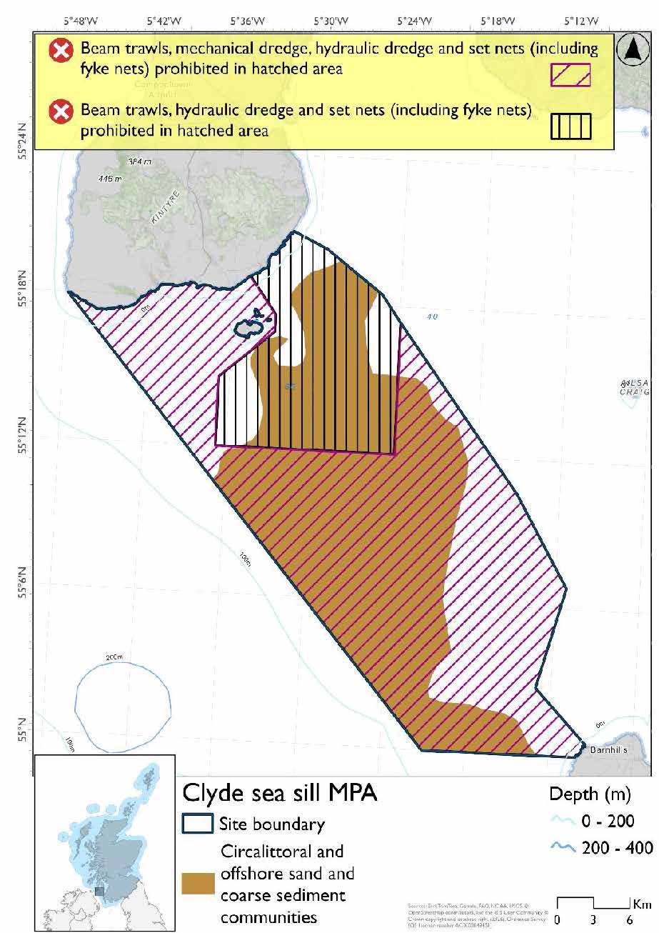
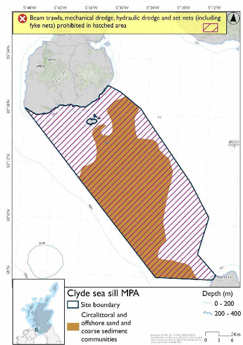
The proposed management measures for Clyde Sea Sill NCMPA are as follows.
Option 1
- Full site closure to beam trawls, set nets (includes fyke nets) and hydraulic dredge
- Mechanical dredge prohibited in part of the site
Option 2
- Full site closure to beam trawls, set nets (includes fyke nets), hydraulic dredge and mechanical dredge
Rationale for developed measures
The basis for the proposed fisheries management measures for each site has been determined by the management advice for fishing activities provided by NatureScot, which can be found on their website or Sitelink as signposted throughout this document. The Fisheries Assessment for each site assesses the impacts from existing fishing activities on the protected features using the tests from the legislation relevant for the type of MPA being considered. The assessment outlines how the proposed measures address any impacts identified that could hinder the conservation objectives of the MPA.
8.1.7 Other fisheries management measures currently applying to this site
There are already management measures in place. An effort has been made to identify existing measures which affect each individual site or area, however the list may not be exhaustive. These measures are outlined below, and the proposals for further management being consulted on now are in addition to these existing measures:
- Fishing for sandeel is prohibited within the Scottish zone, which is defined as the sea adjacent to Scotland up to the 200 nautical miles limit
- Fishing for sea fish by any method, by any British fishing boat, is prohibited in part of the site all year
- Fishing for sea fish with mobile or active gear prohibited from midnight on Friday until midnight on Sunday across part of the site all year
- Fishing for any species of sea fish (except herring, mackerel and sprats) from a fishing boat with an overall length not greater than 21.34 metres prohibited across part of the site all year
Other conservation measures can be found in section 7 of the CMA .
8.2 Ailsa Craig SPA
8.2.1 Description and background
Ailsa Craig SPA is an island rising to 338m, situated in the outer part of the Firth of Clyde. Cliffs up to 100m encircle the island and provide nesting sites for a variety of seabirds, notably one of the largest gannet colonies in the world with around 23,000 breeding pairs, representing approximately 8.7% of the global biogeographic population. The island also hosts significant populations of lesser black-backed gull (1,800 pairs), guillemot, kittiwake, and herring gull, contributing to a total seabird assemblage of over 65,000 individuals.
Ailsa Craig SPA comprises the island itself, and the adjacent coastal waters extending 2 km into the marine environment. The surrounding marine waters support a variety of natural resources, including molluscs, crustaceans, marine worms, pelagic and demersal fish species together with the birds and mammals that feed on them.
The rich and varied natural resources present within the SPA give rise to a range of benefits to people. Whilst the island is now uninhabited, except for scientific study, the seascapes and wildlife within the SPA provide opportunities for tourism and wildlife watching in particular, all of which encourage local jobs and businesses. Fisheries and supporting businesses from local communities around the SPA utilise and benefit from the wildlife and the area’s fish resources.
Further information, including Conservation and Management Advice (CMA) can be found on Sitelink.
Further information on MPAs, the wider network and protected areas management is available at Scottish Government MPA policy page.
8.2.2 Protected features
Ailsa Craig SPA has been designated to protect:
- Gannet;
- Guillemot;
- Herring gull;
- Kittiwake; and
- Lesser black-backed gull
The protected features of the Ailsa Craig SPA are protected within the SPA throughout the year, irrespective of the season for which they qualified as a protected feature.
8.2.3 Conservation Objectives
The following protected features are in favourable condition at the Ailsa Craig SPA: guillemot and gannet. Therefore, the Conservation Objectives seek to maintain this condition.
The following protected features are in unfavourable condition at Ailsa Craig SPA: kittiwake, herring gull and lesser black-backed gull. Therefore, the Conservation Objectives seek to restore this condition.
Additional details, including the Conservation Objectives are provided in the Conservation and Management Advice document produced for this SPA and can be found on Sitelink .
8.2.4 Pressure from fishing activity
Several of the protected seabird species are sensitive to accidental bycatch, particularly in surface and pelagic fishing gears. Gannets are among the most susceptible, with additional risks from entanglement in discarded nets. Kittiwakes and guillemots may also be affected by reduced prey availability due to fishing pressure on forage fish, which can impact breeding success and population stability.
Guillemots and gannets, which forage in the water column, are sensitive to increased turbidity caused by fishing activities, as it can impair their ability to locate prey. Guillemots also show sensitivity to visual and noise disturbance from vessels, which may disrupt feeding and nesting behaviour.
Additional details are provided in the Conservation and Management Advice document produced for this SPA (section 6) and can be found on Sitelink.
Other resources include:
- The Feature Activity Sensitivity Tool (FeAST) which allows users to investigate the sensitivity of marine features (habitats, species, geology and landforms) in Scotland's seas, to pressures arising from human activities;
- Fisheries Guidance Notes which provide summaries of evidence on the interaction between fishing gears and specific habitats and species.
8.2.5 Fisheries management advice relevant to proposed fisheries management measures
NatureScot provides risk-based advice to help manage activities that may impact protected features and their Conservation Objectives. See section 2.3 for more detail. The CMA document also sets out the full fisheries management advice that has been summarised below for the management measures proposed:
Hydraulic gear
It is recommended to remove or avoid pressures associated with hydraulic fishing that have the potential to damage seabed habitat (in particular sandeel habitat, and herring spawning grounds). These pressures include removal of prey species and abrasion of prey-supporting habitat.
Static gear
It is recommended to remove or avoid pressures (entanglement) associated with the use of all static nets. Spatial exclusion of all static nets in areas identified as being important for auks and gannet (as identified from habitat and dive depth preferences) is recommended.
Pelagic gear
Pelagic fishing for herring/sprat may occur within or around the SPA. A principal objective of the management of the fishery should be ensuring that the fishing activity does not prevent or disrupt the availability of prey species (i.e. it should be considered as part of a broader ecosystem-based approach to management of this fishery).
Longlining (not including jigging)
Long-lining (pelagic and demersal) may occur within or around the SPA(s). Current understanding is that long-line fisheries are largely restricted to offshore waters. Site-specific measures for long-lining are not currently considered appropriate due to the scale of the fishery, and the wide-spread interaction with seabirds. However, there is evidence of seabird bycatch in long-line (not jigging) fisheries therefore it is recommended this requires wider seas management measures.
For the SPAs advice has also been provided on maximum dive depth and seasonality for protected features of each site and can be found in the Fishing Activity Further Advice and Evidence document. Supplementary advice can also be found on NatureScot’s website.
8.2.6 Proposed fisheries management measures
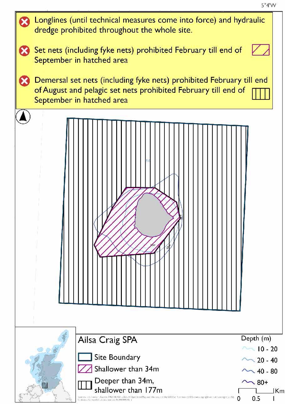
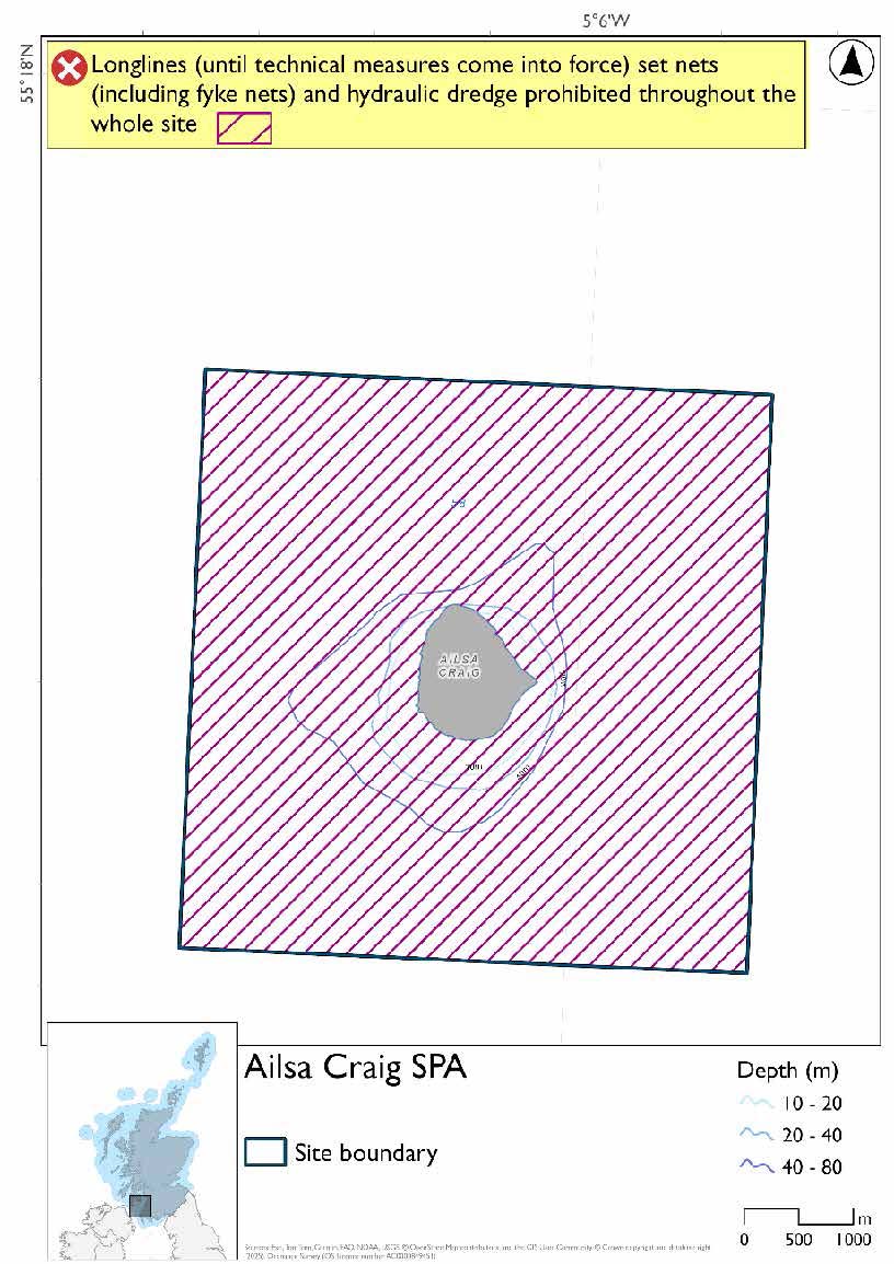
The proposed management measures for Ailsa Craig SPA are as follows.
Option 1
- Set nets (including fyke nets) prohibited from February till end of September in areas shallower than 34m based on presence and maximum dive depth for gannet
- Demersal set nets (including fyke nets) prohibited from February until the end of August in areas deeper than 34m but shallower than 177m, based on presence and maximum dive depth of guillemot, and pelagic set nets prohibited February till end of September, in the same area based on presence of gannet
- Full site closure to longlines (until technical measures come into force) and hydraulic dredge
Option 2
- Full site closure to longlines (until technical measures come into force), set nets (including fyke nets) and hydraulic dredge
Rationale for developed measures
The basis for the proposed fisheries management measures for each site has been determined by the management advice for fishing activities provided by NatureScot, which can be found on their website or Sitelink as signposted throughout this document. The Fisheries Assessment for each site assesses the impacts from existing fishing activities on the protected features using the tests from the legislation relevant for the type of MPA being considered. The assessment outlines how the proposed measures address any impacts identified that could hinder the conservation objectives of the MPA.
8.2.7 Other fisheries management measures currently applying to this site
There are already management measures in place. An effort has been made to identify existing measures which affect each individual site or area, however the list may not be exhaustive. These measures are outlined below, and the proposals for further management being consulted on now are in addition to these existing measures:
- Fishing for sandeel is prohibited within the Scottish zone, which is defined as the sea adjacent to Scotland up to the 200 nautical miles limit
- Fishing for sea fish with mobile or active gear prohibited from midnight on Friday until midnight on Sunday across the site all year
- Fishing for any species of sea fish (except herring, mackerel and sprats) from a fishing boat with an overall length not greater than 21.34 metres prohibited across the site all year
Other conservation measures can be found in section 7 of the CMA.
Contact
Email: marine_biodiversity@gov.scot