
Fisheries Management Measures within Scottish Inshore Marine Protected Areas (MPAs) and Proposed Priority Marine Feature (PMF) Management Areas - Site and Area Proposal Document
This document describes the process, justification and evidence used to develop site and area specific fisheries management measures. It outlines key information for each site and area including their features, and risks of potential pressures.

14. Sites in the Outer Hebrides Region
14.1 Monach Isles NCMPA and Monach Islands SAC
14.1.1 Description and background
The Monach Isles, located off the west coast of North Uist in the Outer Hebrides, form a remote and ecologically important island group protected through both a NCMPA and a SAC. Together, these overlapping designations reflect the site’s exceptional importance for biodiversity and geodiversity, encompassing both terrestrial habitats and surrounding marine environments.
The Monach Isles NCMPA was designated to protect black guillemot populations and significant marine geomorphological features. Black guillemots at this site exhibit an unusual nesting behaviour, breeding within sand dune systems such as rabbit burrows rather than rocky crevices. The adjacent shallow coastal waters provide essential feeding habitat, supporting the species year‑round. The NCMPA also safeguards geomorphological features shaped by glacial and coastal processes, including dynamic sediment systems and seabed landforms of scientific importance.
The Monach Isles SAC focuses on the protection of machair habitat and grey seal populations. The islands support one of the most extensive and best‑preserved examples of machair, a rare calcareous grassland found only in the northwest of Scotland and western Ireland. These habitats, along with associated sand dunes and intertidal zones, support a rich diversity of plant and animal life and remain largely undisturbed due to the islands being uninhabited since the mid‑20th century. The SAC also encompasses critical breeding and haul‑out areas for grey seals, with the Monach Isles supporting the largest breeding colony in the UK, accounting for a significant proportion of national pup production.
Further information, including Conservation and Management Advice can be found on Sitelink by searching for each site individually. These sites will have some separate information for each but management is being taken forward jointly.
Further information on MPAs, the wider network and protected areas management is available at Scottish Government MPA policy page.
14.1.2 Protected features
The Monach Islands are designated as a SAC to protect:
- Grey seal
- Dune grassland;
- Machair; and
- Shifting dunes with marram
As an NCMPA to protect:
- Black guillemot;
- Marine Geomorphology of the Scottish Shelf Seabed; and
- Quaternary of Scotland.
Dune grassland, machair, shifting dunes with marram, Marine Geomorphology of the Scottish Shelf Seabed and Quaternary of Scotland are not discussed further as they are not protected features for which fisheries management measures are required.
14.1.3 Conservation Objectives
All of the features of the Monach Islands SAC are in favourable condition and therefore the Conservation Objectives seek to maintain this condition.
Black guillemot are in unfavourable condition at Monach Isles NCMPA and therefore Conservation Objectives seek to recover this condition.
Additional details, including the Conservation Objectives, are provided in the Conservation and Management Advice document produced for these sites. They can be found on Sitelink by searching for each site individually.
14.1.4 Pressure from fishing activity
Fishing activities can exert multiple pressures on marine and coastal protected features, notably grey seals and black guillemots. Grey seals are sensitive to entanglement in fishing gear, which can cause injury or mortality, particularly among pups.
Black guillemots face similar risks, with accidental bycatch and entanglement in nets posing severe local population impacts. As inshore feeders reliant on kelp‑associated benthic prey, they are highly exposed to prey depletion and habitat degradation from overfishing and seabed disturbance. The loss of prey‑supporting habitats compounds these pressures, as guillemots remain resident year‑round and forage close to breeding sites.
Additional details are provided in the Conservation and Management Advice documents (section 6) provided on Sitelink for Monach Islands NCMPA and Monach Isles SAC.
Other resources include:
- The Feature Activity Sensitivity Tool (FeAST) which allows users to investigate the sensitivity of marine features (habitats, species, geology and landforms) in Scotland's seas, to pressures arising from human activities;
- Fisheries Guidance Notes which provide summaries of evidence on the interaction between fishing gears and specific habitats and species.
14.1.5 Fisheries management advice relevant to proposed fisheries management measures
NatureScot provides risk-based advice to help manage activities that may impact protected features and their Conservation Objectives. See section 2.3 for more detail. The CMA document also sets out the full fisheries management advice that has been summarised below for the management measures proposed:
Hydraulic (diver or vessel)
Remove or avoid pressures (removal of prey species and disturbance of prey-supporting habitat) associated with hydraulic fishing that has the potential to damage seabed habitat (in particular, sandeel habitat, herring spawning grounds) is recommended.
Static gear (including bottom set nets, drift nets, fyke nets)
Remove or avoid pressures (entanglement) associated with the use of all static nets. Spatial exclusion of all static nets in areas identified as being important for black guillemot (as identified from habitat and dive depth preferences) is recommended.
Netting - (Bottom-set gill nets including tangle and trammel nets. Drift nets, purse seine, ring-nets and fyke nets.)
Reduce or limit pressures (entanglement) associated with the use of nets is recommended for grey seals.
14.1.6 Proposed fisheries management measures
The proposed management measure for Monach Isles NCMPA and Monach Islands SAC is as follows:
Single Proposed Management Option
- Full site closure to pelagic seine (including ring-nets) set nets (including fyke nets) and hydraulic dredge
Figure 62. Map of measures proposed
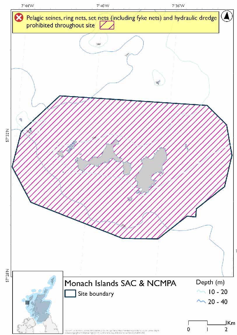
A full site level of protection from the specified gear has been identified as the only suitable option in enabling the achievement of the desired level of protection for the feature in question.
Overlapping site included in this consultation
This NCMPA and SAC overlaps with the West Coast of the Outer Hebrides SPA.
Rationale for measures developed
The basis for the proposed fisheries management measures for each site has been determined by the management advice for fishing activities provided by NatureScot, which can be found on their website or Sitelink as signposted throughout this document. The Fisheries Assessment for each site assesses the impacts from existing fishing activities on the protected features using the tests from the legislation relevant for the type of MPA being considered. The assessment outlines how the proposed measures address any impacts identified that could hinder the conservation objectives of the MPA.
14.1.7 Other fisheries management measures currently applying to this site
There are already management measures in place. An effort has been made to identify existing measures which affect each individual site or area, however the list may not be exhaustive. These measures are outlined below, and the proposals for further management being consulted on now are in addition to these existing measures:
- Fishing for sandeel is prohibited within the Scottish zone, which is defined as the sea adjacent to Scotland up to the 200 nautical miles limit
- Fishing for any species of sea fish with a creel or parlour creel is prohibited from 01 November till 31st March each year in part of the site
Other conservation measures can be found in section 7 of the CMA.
14.2 North-East Lewis NCMPA
14.2.1 Description and background
The North‑East Lewis NCMPA lies off the north‑east coast of the Isle of Lewis in the Outer Hebrides, extending from Tolsta Head in the north to Tiumpan Head in the south. Covering approximately 13,800 hectares, the site encompasses a diverse area of inshore waters, intertidal habitats and offshore seabed, forming an ecologically rich coastal system influenced by strong tidal currents and varied sediment types.
The NCMPA is designated to protect a combination of biodiversity and geodiversity features, including sandeel populations, Risso’s dolphin, and representative seabed geomorphological features. Sandy seabed habitats within the site provide important conditions for sandeel burrowing and spawning, supporting a key prey species that underpins wider marine food webs, including seabirds, marine mammals and commercially important fish. The area is also used by Risso’s dolphins, which forage in these waters and contribute to the site’s importance for mobile marine species.
A range of habitats is present, including bedrock reefs, kelp-dominated areas, and intertidal sand and mud flats, which support diverse benthic communities, juvenile fish and invertebrates. The site also includes comparatively rare low or variable salinity habitats, further adding to its ecological diversity. In addition, the NCMPA protects notable geodiversity features, such as sediment wave fields and glacially influenced seabed structures, which provide valuable insight into past and ongoing geological processes.
Further information, including Conservation and Management Advice (CMA) can be found on Sitelink.
Further information on MPAs, the wider network and protected areas management is available at Scottish Government MPA policy page.
14.2.2 Protected Features
The North-East Lewis NCMPA has been selected to protect:
- Marine Geomorphology of the Scottish Shelf Seabed;
- Quaternary of Scotland;
- Risso’s dolphin; and
- Sandeels
Marine geomorphology of the Scottish Shelf Seabed and Quaternary of Scotland are not discussed further as they are not protected features for which fisheries management measures are required.
14.2.3 Conservation Objectives
All of the biodiversity features are in favourable condition at North-east Lewis NCMPA and therefore the Conservation Objectives seek to conserve this condition.
Additional details, including the Conservation Objectives, are provided in the Conservation and Management Advice document produced for this NCMPA and can be found on Sitelink.
14.2.4 Pressure from fishing activity
Fishing activities exert multiple pressures on Risso’s dolphins, primarily through entanglement, vessel collision, prey depletion, and habitat degradation. Nets, ropes, and propeller strikes pose direct risks, causing injury or mortality, while underwater noise from fishing vessels disrupts communication, foraging, and displaces dolphins from key feeding areas, reducing prey capture and increasing energetic costs.
Indirect impacts arise from prey depletion, particularly through targeted sandeel fisheries and broader commercial removal of forage species. Reduced sandeel abundance diminishes food availability, lowers recruitment and body condition across the food web, and forces dolphins to forage further or switch to less suitable prey, amplifying energetic demands and exposure to vessel interactions.
Fishing methods that disturb the seabed, including bottom‑contact gears and trawling, degrade sandeel habitats by altering sediment composition and increasing siltation, reducing prey density and recovery potential. These combined pressures, gear‑related mortality, prey loss, and habitat damage, undermine foraging success, reproduction, and long‑term population resilience of Risso’s dolphins.
Additional details are provided in the Conservation and Management Advice document produced for this NCMPA (section 6) and can be found on Sitelink.
Other resources include:
- The Feature Activity Sensitivity Tool (FeAST) which allows users to investigate the sensitivity of marine features (habitats, species, geology and landforms) in Scotland's seas, to pressures arising from human activities;
- Fisheries Guidance Notes which provide summaries of evidence on the interaction between fishing gears and specific habitats and species.
14.2.5 Fisheries management advice relevant to proposed fisheries management measures
NatureScot provides risk-based advice to help manage activities that may impact protected features and their Conservation Objectives. See section 2.3 for more detail. The CMA document also sets out the full fisheries management advice that has been summarised below for the management measures proposed:
Hydraulic (diver or vessel)
Remove or avoid pressures. The exclusion of hydraulic fishing methods from habitat supporting sandeels within the site is recommended.
Static gear
Reduce or limit pressures Exclusion of the use of drift nets and nets set on the seabed (tangle, trammel, gill) due to the risk of entanglement is recommended.
Pelagic gear
Reduce or limit pressures The development and adoption of best practice to reduce or limit the risk of incidental catch of Risso’s dolphins should be considered.
14.2.6 Proposed fisheries management measures
The proposed management measures for North-East Lewis NCMPA are as follows:
Option One
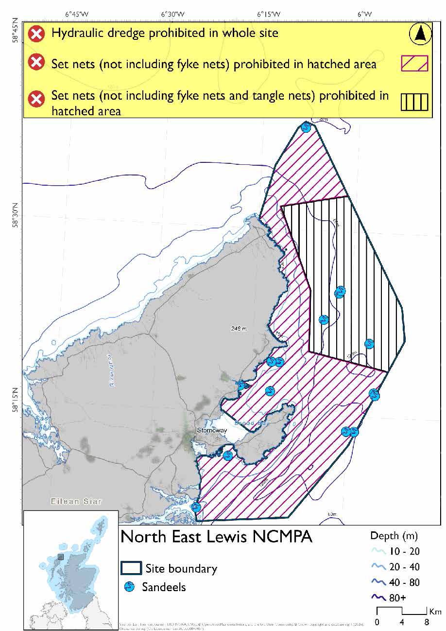
- Set nets (not including fyke nets) to be prohibited throughout the site apart from an exclusion zone that will allow tangle nets
- Full site closure to hydraulic dredge
Figure 63. Map of measures proposed under option 1
Option Two
- Full site closure to set nets (not including fyke nets) and hydraulic dredge
Figure 64. Map of measures proposed under option 2
Overlapping site included in this consultation
This NCMPA overlaps with the Inner Hebrides and the Minches SAC.
Rationale for measures developed
The basis for the proposed fisheries management measures for each site has been determined by the management advice for fishing activities provided by NatureScot, which can be found on their website or Sitelink as signposted throughout this document. The Fisheries Assessment for each site assesses the impacts from existing fishing activities on the protected features using the tests from the legislation relevant for the type of MPA being considered. The assessment outlines how the proposed measures address any impacts identified that could hinder the conservation objectives of the MPA.
14.2.7 Other fisheries management measures currently applying to this site
There are already management measures in place. An effort has been made to identify existing measures which affect each individual site or area, however the list may not be exhaustive. These measures are outlined below, and the proposals for further management being consulted on now are in addition to these existing measures:
- Fishing for sandeel is prohibited within the Scottish zone, which is defined as the sea adjacent to Scotland up to the 200 nautical miles limit
- Fishing for sea fish with mobile or active gear prohibited across part of the site (Broad Bay)
Other conservation measures can be found in section 7 of the CMA.
14.3 Shiant East Bank NCMPA
14.3.1 Description and background
Positioned in the middle of the Minch, the Shiant East Bank NCMPA has been identified to protect the biologically diverse and dynamic marine environment that has evolved over the last ten thousand years. The complex underwater landscape around the bank is a legacy from the end of the last ice age, when the ice sheet that once covered most of Scotland retreated.
Throughout the Shiant East Bank NCMPA, strong currents generated by the tides create mosaics of sand and mixed sediments favoured by marine worms, clams, brittlestars, crabs and starfish.
Exposed outcrops of more resistant volcanic rocks provide an elevated position for filter feeders such as northern sea fans and sponges to take advantage of the nutrient laden waters.
The large, irregular shaped banks and mounds create turbulence that draws up relatively cool and nutrient rich waters from the deep, mixing it with warmer shallower waters. This churning greatly increases the availability of food, attracting small fish and crabs which in turn draw top predators like whales, dolphins, porpoises and seabirds to the area.
The sea floor within the NCMPA shows extensive signs of scarring caused by the passage of glaciers that started their journey well inland, carving out sediments from the fjords of Loch Broom and Little Loch Broom all the way out to the edge of the continental slope. The outstanding range of glacial processes visible throughout this region, above and below the waves, makes this an area of international geological importance
Further information, including Conservation and Management Advice (CMA) can be found on Sitelink
Further information on MPAs, the wider network and protected areas management is available at Scottish Government MPA policy page.
14.3.2 Protected features
The Shiant East Bank NCMPA has been designated to protect:
- Circalittoral sand and mixed sediment communities;
- Northern sea fan and sponge communities;
- Quaternary of Scotland; and
- Shelf banks and mounds
Quaternary of Scotland and shelf banks and mounds are not discussed further as they are not protected features for which fisheries management measures are required.
14.3.3 Conservation Objectives
All of the biodiversity features are in favourable condition at Shiant East Bank NCMPA and therefore the Conservation Objectives seek to conserve this condition.
Additional details, including the Conservation Objectives, are provided in the Conservation and Management Advice document produced for this NCMPA and can be found on Sitelink.
14.3.4 Pressure from fishing activity
Most of the protected features are sensitive to abrasion and physical disturbance. Circalittoral sands and mixed sediment communities and northern sea fan and sponge communities have slow recovery rates, where recovery is possible at all. Changes in the sediment type, removal of substratum, and changes in siltation rates can have significant effects. Northern sea fan and sponge communities are also sensitive to burial.
Additional details are provided in the Conservation and Management Advice document produced for this NCMPA (section 6) and can be found on Sitelink.
Other resources include:
- The Feature Activity Sensitivity Tool (FeAST) which allows users to investigate the sensitivity of marine features (habitats, species, geology and landforms) in Scotland's seas, to pressures arising from human activities;
- Fisheries Guidance Notes which provide summaries of evidence on the interaction between fishing gears and specific habitats and species.
14.3.5 Fisheries management advice relevant to proposed fisheries management measures
NatureScot provides risk-based advice to help manage activities that may impact protected features and their Conservation Objectives. See section 2.3 for more detail. The CMA document also sets out the full fisheries management advice that has been summarised below for the management measures proposed:
Demersal mobile/active gear
Circalittoral sand and mixed sediment communities – reduce or limit pressures. Management measures to reduce or limit demersal/mobile active gear from circalittoral sand and mixed sediment communities is recommended.
Northern sea fan and sponge communities - Removal or avoidance of pressures associated with mobile and active fishing is recommended.
Hydraulic (diver or vessel)
Circalittoral sand and mixed sediment communities – reduce or limit pressures. Management measures to reduce or limit hydraulic fishing from circalittoral sand and mixed sediment communities is recommended.
Northern sea fan and sponge communities - Removal or avoidance of pressures associated with hydraulic fishing is recommended.
14.3.6 Proposed fisheries management measures
The proposed management measures for Shiant East Bank NCMPA are as follows:
Option One*
- All demersal mobile gear (demersal trawls and seines, beam trawl, mechanical dredge and hydraulic dredge) prohibited in part of the site
Figure 65. Map of measures proposed under option 1
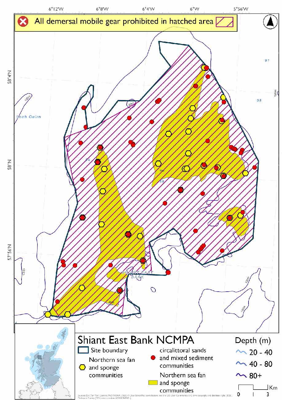
*This site will have static measures that may apply from the overlapping portion of the Inner Hebrides and the Minches SAC. These are not shown on the map but will prohibit set nets (not including fyke nets) from the whole site.
Option Two*
- Full site closure to all demersal mobile gear (demersal trawls and seines, beam trawl, mechanical dredge and hydraulic dredge)
Figure 66. Map of measures proposed under option 2
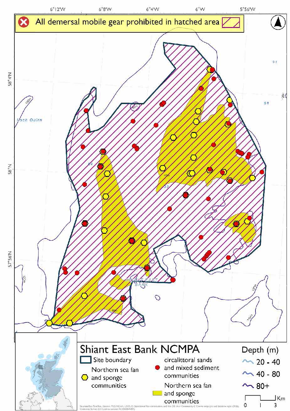
*The measures for Option 2 proposals only come from gear types prohibited in non-overlapping areas. Overlapping restrictions may still apply from overlapping sites or areas dependent on the decisions taken for that site or area.
Overlapping site included in this consultation
This NCMPA overlaps with the Inner Hebrides and the Minches SAC.
Rationale for developed measures
The basis for the proposed fisheries management measures for each site has been determined by the management advice for fishing activities provided by NatureScot, which can be found on their website or Sitelink as signposted throughout this document. The Fisheries Assessment for each site assesses the impacts from existing fishing activities on the protected features using the tests from the legislation relevant for the type of MPA being considered. The assessment outlines how the proposed measures address any impacts identified that could hinder the conservation objectives of the MPA.
14.3.7 Other fisheries management measures currently applying to this site
There are already management measures in place. An effort has been made to identify existing measures which affect each individual site or area, however the list may not be exhaustive. These measures are outlined below, and the proposals for further management being consulted on now are in addition to these existing measures:
- Fishing for sandeel is prohibited within the Scottish zone, which is defined as the sea adjacent to Scotland up to the 200 nautical miles limit
Other conservation measures can be found in section 7 of the CMA.
14.4 Loch nam Madadh SAC
14.4.1 Description and background
Loch nam Madadh SAC encompasses the sheltered waters of Loch nam Madadh (Loch maddy) on North Uist, forming a complex system of interconnected marine and lagoonal environments. The site includes a diverse range of habitats influenced by tidal exchange, freshwater inputs and varied geomorphology, creating a rich and dynamic coastal ecosystem.
The SAC supports a wide variety of marine habitats, including sandbanks, reefs, maerl beds and lagoonal basins, which together underpin highly diverse biological communities. These habitats provide important resources, including fish and shellfish populations and seaweed communities, and support a range of invertebrates and juvenile fish. In turn, these contribute essential feeding and nursery grounds for seabirds and other marine species.
The site’s ecological importance lies in the strong connectivity between its open coastal waters, intertidal areas and enclosed lagoon systems, which function as a single, integrated unit. This connectivity supports key processes such as nutrient exchange, sediment movement and habitat formation, all of which are fundamental to maintaining the integrity of the system.
Further information, including Conservation and Management Advice (CMA) can be found on Sitelink.
Further information on MPAs, the wider network and protected areas management is available at Scottish Government MPA policy page.
14.4.2 Protected features
The Loch nam Madadh SAC has been designated to protect:
- Intertidal mudflats and sandflats;
- Lagoons;
- Large shallow inlets and bays;
- Otter;
- Reefs; and
- Subtidal sandbanks
Otter is not discussed further as they are not a protected feature for which fisheries management measures are required.
14.4.3 Conservation Objectives
All of the protected features are in favourable condition at Loch nam Madadh SAC and therefore the Conservation Objectives seek to maintain this condition.
Additional details, including the Conservation Objectives, are provided in the Conservation and Management Advice document produced for this SAC and can be found on Sitelink.
14.4.4 Pressure from fishing activity
Fishing activities exert multiple pressures on marine habitats, primarily through physical disturbance, smothering, siltation and changes in water flow or quality. Rocky reef habitats are highly sensitive to disturbance, which can detach sessile organisms and block water exchange, though recovery may be relatively quick if pressures are removed. Intertidal mudflats and sandflats are sensitive to physical change with typically low resilience and slow recovery. Lagoons are most sensitive to permanent changes in salinity and water flow, with low resilience to physical and water quality changes, meaning recovery is often slow. Seagrass beds are easily uprooted by disturbance and highly sensitive to changes in water clarity and flow, with poor recovery potential.
Subtidal sandbanks are sensitive to physical disturbance of the seabed, the introduction of invasive species, and declines in water quality. Large shallow inlets and bays include a range of habitats and are therefore exposed to all of these pressures combined. Tidal rapids are sensitive to changes in water flow and siltation but may recover more quickly once pressures are removed. Maerl beds are among the most sensitive habitats, with their three‑dimensional structure easily damaged by crushing, burial, or sediment disruption. Increased sedimentation smothers maerl and associated fauna, blocking oxygen and nutrient exchange. Due to their exceptionally slow growth rate, maerl beds have negligible recovery potential, making them particularly sensitive to fishing‑related impacts.
Additional details are provided in the Conservation and Management Advice document produced for this SAC (section 6) and can be found on Sitelink.
Other resources include:
- The Feature Activity Sensitivity Tool (FeAST) which allows users to investigate the sensitivity of marine features (habitats, species, geology and landforms) in Scotland's seas, to pressures arising from human activities;
- Fisheries Guidance Notes which provide summaries of evidence on the interaction between fishing gears and specific habitats and species.
14.4.5 Fisheries management advice relevant to proposed fisheries management measures
NatureScot provides risk-based advice to help manage activities that may impact protected features and their Conservation Objectives. See section 2.3 for more detail. The CMA document also sets out the full fisheries management advice that has been summarised below for the management measures proposed:
Demersal mobile/active gear
Reefs – remove or avoid pressures is recommended.
Subtidal sandbanks – reduce or limit pressures is recommended.
Large shallow inlet and bays – reduce or limit pressures is recommended. Remove or avoid pressure on maerl beds is recommended.
Hydraulic (diver or vessel)
Intertidal mudflats and sandflats and subtidal sandbanks – reduce or limit pressures is recommended.
Large shallow inlets and bays – reduce or limit pressures is recommended. Remove or avoid pressure on maerl beds is recommended.
14.4.6 Proposed fisheries management measures
The proposed management measures for Loch nam Madadh SAC are as follows:
Option One*
- Demersal trawl and seine, beam trawl, mechanical dredges and hydraulic dredges prohibited in part of the site
Figure 67. Map of measures proposed under option 1
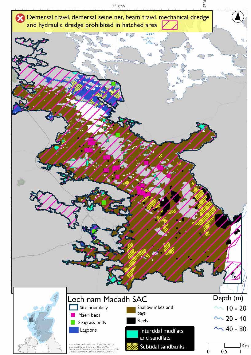
* This site will have static measures that may apply in part of the site from the overlapping portion of the Inner Hebrides and the Minches SAC. These are not shown on the map for this option but will prohibit set nets (not including fyke nets).
Please check the Option 1 overlapping site map to see proposed set net measures under Option 1.
Option Two*
- Full site closure to demersal trawl and seine, beam trawl, mechanical dredge and hydraulic dredge
Figure 68. Map of measures proposed under option 2
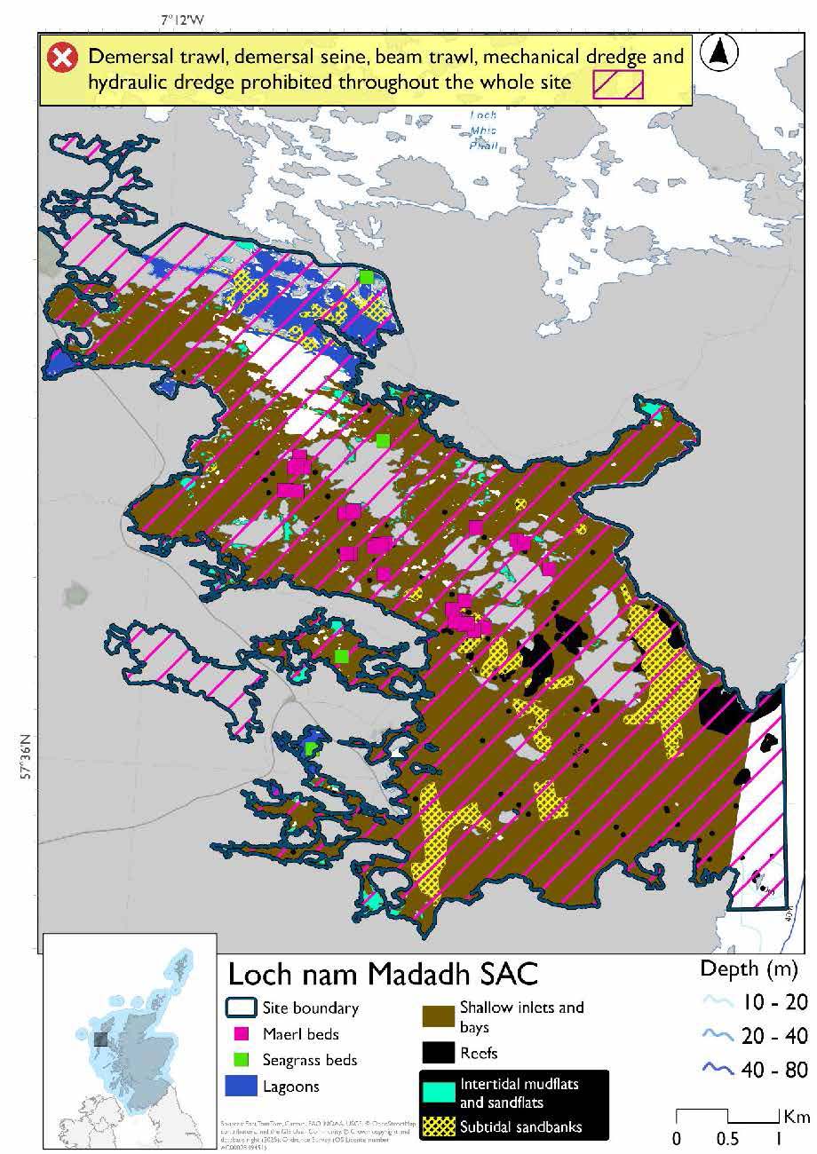
*The measures for Option 2 proposals only come from gear types prohibited in non-overlapping areas. Overlapping restrictions may still apply from overlapping sites or areas dependent on the decisions taken for that site or area.
Overlapping site included in this consultation
This site overlaps with the Sea of the Hebrides NCMPA.
Rationale for developed measures
The basis for the proposed fisheries management measures for each site has been determined by the management advice for fishing activities provided by NatureScot, which can be found on their website or Sitelink as signposted throughout this document. The Fisheries Assessment for each site assesses the impacts from existing fishing activities on the protected features using the tests from the legislation relevant for the type of MPA being considered. The assessment outlines how the proposed measures address any impacts identified that could hinder the conservation objectives of the MPA.
14.4.7 Other fisheries management measures currently applying to this site
There are already management measures in place. An effort has been made to identify existing measures which affect each individual site or area, however the list may not be exhaustive. These measures are outlined below, and the proposals for further management being consulted on now are in addition to these existing measures:
- Fishing for sandeel is prohibited within the Scottish zone, which is defined as the sea adjacent to Scotland up to the 200 nautical miles limit
- Prohibition of tractor dredging under the Inshore Fishing (Prohibition of Fishing for Cockles) (Scotland) (No. 3) Order 2006.
Other conservation measures can be found in section 7 of the CMA.
14.5 North Rona SAC
14.5.1 Description and background
The North Rona SAC encompasses the marine environment surrounding the remote island of North Rona, located to the north‑west of mainland Scotland. The site protects a range of important coastal and marine habitats, including rocky reefs, submerged and partially submerged sea caves, and vegetated sea cliffs of the Atlantic coasts, along with their associated species and ecological processes.
The SAC is also of significant importance for grey seals, providing essential habitat for breeding, pupping and haul‑out. In particular, the site’s sea caves and surrounding coastal waters offer sheltered areas that are critical for seal populations.
The SAC has been defined primarily by the distribution of the reef systems surrounding the island, ensuring that key habitats and associated species are included. While not encompassing the full extent of all reef structures in the wider area, the boundary captures a representative range of reef habitats and known ecological features. It also includes waters adjacent to sea caves and coastal zones that are essential to supporting grey seal life cycles.
Further information, including Conservation and Management Advice (CMA) can be found on Sitelink.
Further information on MPAs, the wider network and protected areas management is available at Scottish Government MPA policy page.
14.5.2 Protected features
The North Rona SAC has been designated to protect the following features:
- Grey seal;
- Reefs;
- Sea caves; and
- Vegetated sea cliffs
Sea caves and vegetated sea cliffs are not discussed further as they are not protected features for which fisheries management measures are required.
14.5.3 Conservation Objectives
Reef is in favourable condition at North Rona SAC and therefore the Conservation Objectives seek to maintain this condition.
Grey seal is in unfavourable condition at North Rona SAC and therefore the Conservation Objectives seek to restore this protected feature.
Additional details, including the Conservation Objectives, are provided in the Conservation and Management Advice document produced for this SAC and can be found on Sitelink.
14.5.4 Pressure from fishing activity
Fishing and human activities can exert multiple pressures on typical rocky reef habitats, which are highly sensitive to physical disturbance, smothering, and siltation. Disturbance can detach sessile organisms, while smothering blocks water flow and nutrient exchange for filter feeders. Recovery is possible if pressures are removed, though it depends on disturbance scale and local environmental conditions such as water movement.
Harbour seals are highly sensitive to disturbance at haul‑out sites, especially during breeding and moulting seasons. Human presence on foot or by boat can trigger stampedes into the water, interrupting rest and pup care. While seals may habituate to routine disturbance, novel or prolonged events can cause pup mortality, redistribution of animals, or abandonment of haul‑outs altogether. In the marine environment, seals face risks from underwater noise from vessels and entanglement in fishing gear.
Additional details are provided in the Conservation and Management Advice document produced for this SAC (section 6) and can be found on Sitelink.
Other resources include:
- The Feature Activity Sensitivity Tool (FeAST) which allows users to investigate the sensitivity of marine features (habitats, species, geology and landforms) in Scotland's seas, to pressures arising from human activities;
- Fisheries Guidance Notes which provide summaries of evidence on the interaction between fishing gears and specific habitats and species.
14.5.5 Fisheries management advice relevant to proposed fisheries management measures
NatureScot provides risk-based advice to help manage activities that may impact protected features and their Conservation Objectives. See section 2.3 for more detail. The CMA document also sets out the full fisheries management advice that has been summarised below for the management measures proposed:
Demersal mobile/active gear
Reefs - Removal and avoidance of pressures is recommended
Hydraulic (diver or vessel)
Reefs – remove or avoid pressures is recommended.
Netting (Bottom-set gill nets – including tangle and trammel nets. Drift nets – gill nets set in water column. Purse seines, ring nets, fyke nets)
Grey seals – reduce or limit pressures (entanglement) associated with the use of nets is recommended.
14.5.6 Proposed fisheries management measures
The proposed management measure for North Rona SAC is as follows:
Single Proposed Management Option
- Full site closure to demersal trawl and seine, beam trawl, pelagic seine (including ring-nets), set nets (including fyke nets), mechanical dredge and hydraulic dredge
- Longlines (until technical measures come into force) prohibited from overlap with the North Rona and Sula Sgeir SPA
Figure 69. Map of measures proposed
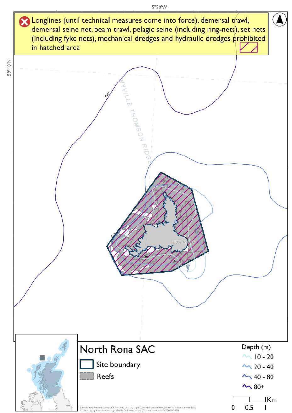
A full site level of protection from the specified gear has been identified as the only suitable option in enabling the achievement of the desired level of protection for the feature in question.
Overlapping site included in this consultation
This SAC overlaps with the North Rona and Sula Sgeir SPA.
Rationale for developed measures
The basis for the proposed fisheries management measures for each site has been determined by the management advice for fishing activities provided by NatureScot, which can be found on their website or Sitelink as signposted throughout this document. The Fisheries Assessment for each site assesses the impacts from existing fishing activities on the protected features using the tests from the legislation relevant for the type of MPA being considered. The assessment outlines how the proposed measures address any impacts identified that could hinder the conservation objectives of the MPA.
14.5.7 Other fisheries management measures currently applying to this site
There are already management measures in place. An effort has been made to identify existing measures which affect each individual site or area, however the list may not be exhaustive. These measures are outlined below, and the proposals for further management being consulted on now are in addition to these existing measures:
- Fishing for sandeel is prohibited within the Scottish zone, which is defined as the sea adjacent to Scotland up to the 200 nautical miles limit
Other conservation measures can be found in section 7 of the CMA.
14.6 Sound of Barra SAC
14.6.1 Description and background
The Sound of Barra SAC spans the marine waters between the southern end of South Uist and the north‑eastern coast of Barra in the Outer Hebrides. It is a topographically complex and highly dynamic coastal system, characterised by a network of tidal channels, sheltered bays and shallow marine areas that support a diverse range of habitats and species.
The SAC includes extensive sandbanks, reefs, maerl beds and seagrass habitats, alongside mixed sediment seabeds that support rich communities of fish, molluscs, crustaceans and other invertebrates. These habitats underpin the productivity of the site, providing important feeding and nursery areas for a wide range of marine species, as well as supporting seabirds such as divers and terns that forage within the Sound.
A key feature of the site is its importance for harbour seals, which use the area for breeding and haul‑out. The sheltered nature of the Sound, together with the availability of suitable coastline and nearby feeding grounds, makes it one of the most significant locations for this species in Scotland.
The ecological value of the Sound of Barra lies in the connectivity between its habitats, with tidal flows and sediment processes linking sandbanks, reefs and vegetated habitats into a cohesive system. This supports high biodiversity and contributes to the resilience of the wider marine ecosystem.
Further information, including Conservation and Management Advice (CMA) can be found on Sitelink.
Further information on MPAs, the wider network and protected areas management is available at Scottish Government MPA policy page.
14.6.2 Protected features
The Sound of Barra SAC has been designated to protect:
- Harbour seal;
- Reef; and
- Subtidal sandbanks
14.6.3 Conservation Objectives
The reefs habitat and harbour seal are in favourable condition at Sound of Barra SAC and therefore the Conservation Objectives seek to maintain favourable condition.
Subtidal sandbanks habitat are in unfavourable condition at the Sound of Barra SAC and therefore the Conservation Objectives seek to restore favourable condition by supporting recovery. The unfavourable condition of subtidal sandbanks at Sound of Barra reflects the condition of the seagrass beds and maerl beds within the site.
Additional details, including the Conservation Objectives, are provided in the Conservation and Management Advice document produced for this SAC and can be found on Sitelink.
14.6.4 Pressure from fishing activity
Fishing and human activities can exert multiple pressures on rocky reef habitats, which are highly sensitive to physical disturbance, smothering, and siltation. Disturbance can detach sessile organisms, while smothering blocks water flow and nutrient exchange for filter feeders. Recovery is possible if pressures are removed, though it depends on disturbance scale and local water movement.
Subtidal sandbanks are sensitive to physical disturbance, invasive non‑native species, and changes in water quality, with generally low resilience. Maerl beds are among the most sensitive habitats, with their three‑dimensional structure easily damaged by crushing, burial, or sediment disruption. Increased sedimentation smothers maerl and associated fauna, blocking oxygen and nutrient exchange. Due to their exceptionally slow growth rate, maerl beds have negligible recovery potential. Seagrass beds are similarly sensitive to changes in water flow, clarity, and quality, and can be uprooted by disturbance. They have low resilience and recover poorly once damaged.
Harbour seals are highly sensitive to disturbance at haul‑out sites, especially during breeding and moulting seasons. Human presence on foot or by boat can trigger stampedes into the water, interrupting rest and pup care. While seals may habituate to routine disturbance, novel or prolonged events can cause pup mortality, redistribution of animals, or abandonment of haul‑outs altogether. In the marine environment, seals face risks from underwater noise from vessels and entanglement in fishing gear.
Additional details are provided in the Conservation and Management
Advice document produced for this SAC (section 6) and can be found on Sitelink.
Other resources include:
- The Feature Activity Sensitivity Tool (FeAST) which allows users to investigate the sensitivity of marine features (habitats, species, geology and landforms) in Scotland's seas, to pressures arising from human activities;
- Fisheries Guidance Notes which provide summaries of evidence on the interaction between fishing gears and specific habitats and species.
14.6.5 Fisheries management advice relevant to proposed fisheries management measures
NatureScot provides risk-based advice to help manage activities that may impact protected features and their Conservation Objectives. See section 2.3 for more detail. The CMA document also sets out the full fisheries management advice that has been summarised below for the management measures proposed:
Demersal mobile/active gear
Reefs – remove or avoid pressures is recommended.
Subtidal sandbanks – remove or avoid pressures is recommended where maerl beds and seagrass beds are present. Spatial exclusion of demersal mobile/active gear is recommended in the areas of these habitats within the site. Reduce or limit pressures is recommended in all other areas. This may be achieved through spatial/temporal restrictions or other measures that reduce the pressure across other areas of subtidal sandbank substrate.
Hydraulic (diver or vessel)
Reefs – remove or avoid pressures is recommended.
Subtidal sandbanks - remove or avoid pressures is recommended where maerl beds or seagrass beds are present. Reduce or limit pressures is recommended in all other areas.
Netting (Bottom-set gill nets including tangle and trammel nets. Drift nets, purse seine, ring-nets and fyke nets.)
Harbour seal – reduce or and limit pressures (entanglement) associated with the use of nets is recommended.
14.6.6 Proposed fisheries management measures
The proposed management measure for Sound of Barra SAC is as follows:
Single Proposed Management Option
- Demersal trawl and seine, beam trawl, set nets (including fyke nets), pelagic seine (including ring-nets), mechanical dredge and hydraulic dredge prohibit
Figure 70. Map of measures proposed
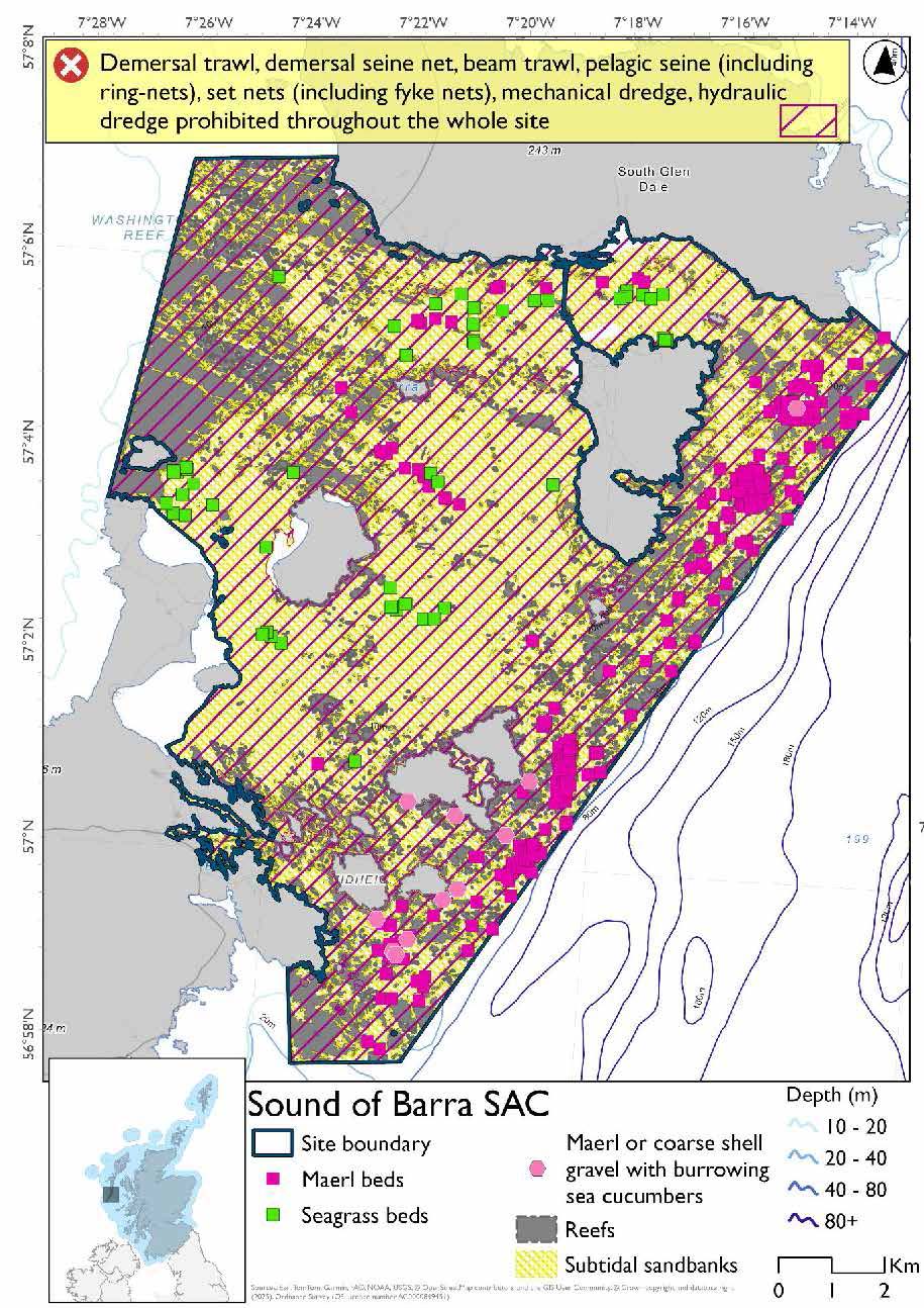
A full site level of protection from the specified gear has been identified as the only suitable option in enabling the achievement of the desired level of protection for the feature in question.
Overlapping site included in this consultation
This SAC overlaps with the West Coast of the Outer Hebrides SPA.
Rationale for developed measures
The basis for the proposed fisheries management measures for each site has been determined by the management advice for fishing activities provided by NatureScot, which can be found on their website or Sitelink as signposted throughout this document. The Fisheries Assessment for each site assesses the impacts from existing fishing activities on the protected features using the tests from the legislation relevant for the type of MPA being considered. The assessment outlines how the proposed measures address any impacts identified that could hinder the conservation objectives of the MPA.
14.6.7 Other fisheries management measures currently applying to this site
There are already management measures in place. An effort has been made to identify existing measures which affect each individual site or area, however the list may not be exhaustive. These measures are outlined below, and the proposals for further management being consulted on now are in addition to these existing measures:
- Fishing for sandeel is prohibited within the Scottish zone, which is defined as the sea adjacent to Scotland up to the 200 nautical miles limit
- Beam trawls, demersal seine or trawls, mechanical or hydraulic dredges, and set nets prohibited across part of the site
- Dredging (but not hydraulic dredging) for scallops prohibited in the site from 1 May till 24 August each year
Other conservation measures can be found in section 7 of the CMA.
14.7 Flannan Isles SPA
14.7.1 Description and background
The SPA comprises a group of seven rocky islands and associated skerries, dominated by steep cliffs and maritime grassland, which provide important nesting habitat for large seabird colonies. The islands form a strategically located breeding site, supporting seabirds that utilise the surrounding marine environment. Their remote location and lack of regular disturbance contribute to their suitability for seabird breeding.
The Flannan Isles SPA supports internationally important populations of storm‑petrel. The site also regularly supports over 20,000 seabirds, with around 50,000 individuals recorded, including nationally important populations of guillemot, razorbill, puffin, fulmar and kittiwake.
The surrounding marine environment is important in supporting the feeding and foraging requirements of these species. The inclusion of the seabed, water column and surface waters helps maintain the environmental conditions and ecological processes that underpin prey availability.
Further information, including Conservation and Management Advice (CMA) can be found on Sitelink.
Further information on MPAs, the wider network and protected areas management is available at Scottish Government MPA policy page.
14.7.2 Protected features
The Flannan Isles SPA is designated to protect:
- Fulmar;
- Guillemot;
- Kittiwake;
- Leach’s petrel;
- Puffin; and
- Razorbill;
The protected features of the Flannan Isles SPA are protected within the SPA throughout the year, irrespective of the season for which they qualified as a protected feature.
14.7.3 Conservation Objectives
The following protected feature is in favourable condition at the Flannan Isles SPA: puffin. Therefore, the Conservation Objectives seek to maintain this condition.
The following protected features are in unfavourable condition at the Flannan Isles SPA: kittiwake, guillemot, Leach’s petrel, fulmar and razorbill. Therefore, the Conservation Objectives seek to restore this condition.
Additional details, including the Conservation Objectives, are provided in the Conservation and Management Advice document produced for this SPA and can be found on Sitelink.
14.7.4 Pressure from fishing activity
Kittiwakes, auks (puffins, guillemots, razorbills), Leach’s petrels, and fulmars all face pressures from human and fishing activities. Accidental bycatch is a major direct threat: kittiwakes are sensitive to surface gears, auks to nets during foraging, and fulmars in longline and surface fisheries.
All protected features are also sensitive to prey depletion driven by fisheries practices, which lowers body condition, breeding success, and chick survival. Loss of predictable discards particularly affects kleptoparasitic species (an animal that lets another animal do the hard work, like hunting or gathering, and then swoops in to take the food) such as fulmars.
Disturbance and displacement are shared concerns. Kittiwakes and auks may be displaced by vessel activity, with guillemots and razorbills especially sensitive to visual and noise disturbance. Fulmars and petrels can desert nests if repeatedly disturbed during incubation, while Leach’s petrels are sensitive to human intrusion at colonies. Increased turbidity from seabed disturbance further impairs foraging efficiency for water‑column feeders such as guillemots and razorbills.
Additional details are provided in the Conservation and Management Advice document produced for this SPA (section 6) and can be found on Sitelink.
Other resources include:
- The Feature Activity Sensitivity Tool (FeAST) which allows users to investigate the sensitivity of marine features (habitats, species, geology and landforms) in Scotland's seas, to pressures arising from human activities;
- Fisheries Guidance Notes which provide summaries of evidence on the interaction between fishing gears and specific habitats and species.
14.7.5 Fisheries management advice relevant to proposed fisheries management measures
NatureScot provides risk-based advice to help manage activities that may impact protected features and their Conservation Objectives. See section 2.3 for more detail. The CMA document also sets out the full fisheries management advice that has been summarised below for the management measures proposed:
Static gear (drift nets and bottom set nets including fyke nets)
Remove or avoid pressures (entanglement) associated with the use of all static nets. Spatial exclusion of all static nets in areas identified as being important for auks (as identified from habitat and dive depth preferences) is recommended.
Hydraulic gear
Remove or avoid pressures (removal of prey species and disturbance of prey-supporting habitat) associated with hydraulic fishing that has the potential to damage seabed habitat (in particular, sandeel habitat, herring spawning grounds) is recommended.
Pelagic gear
Pelagic fishing for herring/sprat may occur within or around the SPA. It is recommended that a principal objective of the management of the fishery should be ensuring that the fishing activity does not prevent or disrupt the availability of prey species i.e. it should be considered as part of a broader ecosystem-based approach to management of this fishery.
Longlining (not including jigging)
Long-lining (pelagic and demersal) may occur within or around the SPA(s). Current understanding is that long-line fisheries are largely restricted to offshore waters. Site-specific measures for long-lining are not currently considered appropriate due to the scale of the fishery, and the wide-spread interaction with seabirds. However, there is evidence of seabird bycatch in long-line (not jigging) fisheries therefore it is recommended this requires wider seas management measures.
For the SPAs advice has also been provided on maximum dive depth and seasonality for protected features of each site and can be found in the Fishing Activity Further Advice and Evidence document. Supplementary advice can also be found on NatureScot’s website.
14.7.6 Proposed fisheries management measures
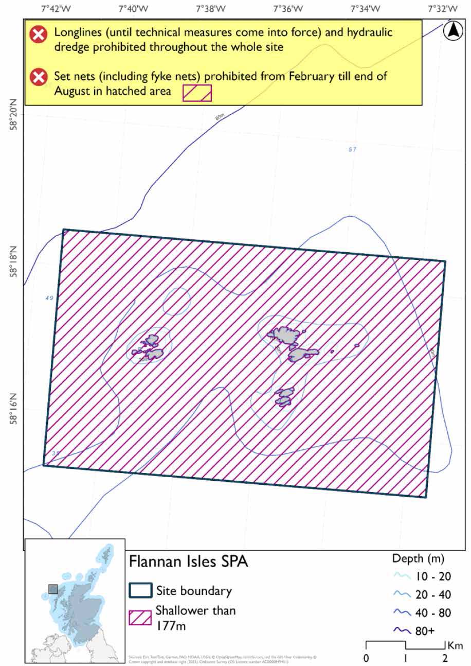
The proposed management measures for Flannan Isles SPA are as follows:
Option One
- Set nets (including fyke nets) prohibited from February till end of August in areas down to 177m based on presence and maximum dive depth for guillemot
- Full site closure to longlines (until technical measures come into force) and hydraulic dredge
Figure 71. Map of measures proposed under option 1
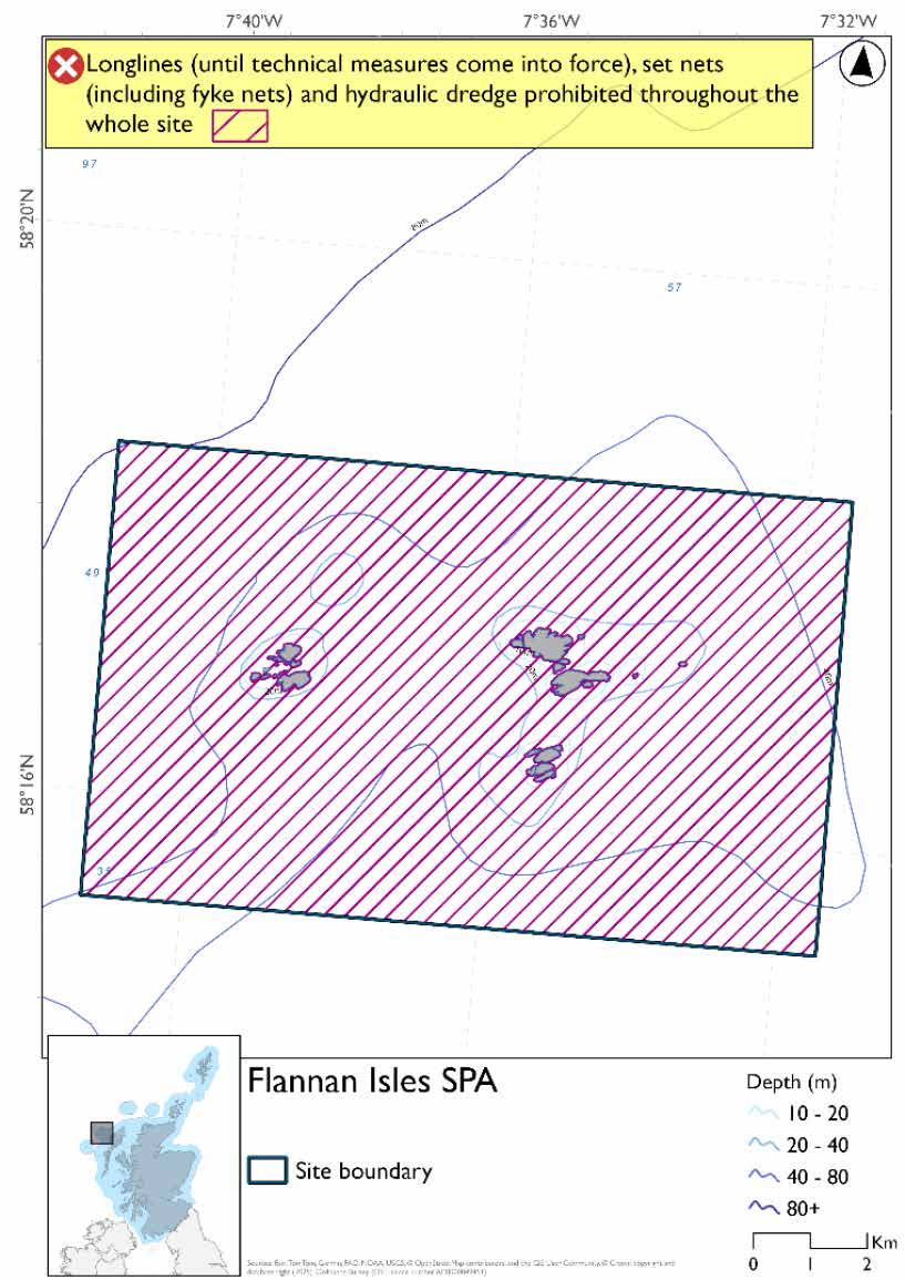
Option Two
- Full site closure to longlines (until technical measures come into force), set nets (including fyke nets) and hydraulic dredge
Figure 72. Map of measures proposed under option 2
Rationale for developed measures
The basis for the proposed fisheries management measures for each site has been determined by the management advice for fishing activities provided by NatureScot, which can be found on their website or Sitelink as signposted throughout this document. The Fisheries Assessment for each site assesses the impacts from existing fishing activities on the protected features using the tests from the legislation relevant for the type of MPA being considered. The assessment outlines how the proposed measures address any impacts identified that could hinder the conservation objectives of the MPA.
14.7.7 Other fisheries management measures currently applying to this site
There are already management measures in place. An effort has been made to identify existing measures which affect each individual site or area, however the list may not be exhaustive. These measures are outlined below, and the proposals for further management being consulted on now are in addition to these existing measures:
- Fishing for sandeel is prohibited within the Scottish zone, which is defined as the sea adjacent to Scotland up to the 200 nautical miles limit
- Fishing for sea fish with creels prohibited from 01 December till 31 March each year across the whole site
Other conservation measures can be found in section 7 of the CMA.
14.8 Mingulay and Berneray SPA
14.8.1 Description and background
The Mingulay and Berneray SPA consists of two adjoining islands at the southern end of the Outer Hebrides, characterised by predominantly cliffed, rocky coastlines and maritime vegetation. These steep cliffs and coastal slopes provide extensive nesting habitat for seabirds, and the islands form an important and relatively undisturbed breeding site due to their remote location. The SPA includes a marine extension of approximately 2 km, encompassing the seabed, water column and surface waters, ensuring that marine areas associated with the colonies are included within the site.
The surrounding marine environment is important for supporting the feeding and foraging requirements of these species, with the marine extension ensuring access to the prey resources associated with the colonies during the breeding season. Inclusion of the seabed, water column and surface waters helps maintain the ecological processes that underpin prey availability and support seabird populations.
Mingulay and Berneray SPA support tens of thousands of breeding seabirds each summer. Key species include kittiwake, guillemot, razorbill, puffin, shag and fulmar, all present in internationally important numbers. The seabirds depend on the productive marine environment around the islands to rear their chicks.
Further information, including Conservation and Management Advice (CMA) can be found on Sitelink.
Further information on MPAs, the wider network and protected areas management is available at Scottish Government MPA policy page.
14.8.2 Protected features
The Mingulay and Berneray SPA has been designated to protect:
- Fulmar;
- Guillemot;
- Kittiwake;
- Puffin;
- Razorbill; and
- Shag
The protected features of the Mingulay and Berneray SPA are protected within the SPA throughout the year, irrespective of the season for which they qualified as a protected feature.
14.8.3 Conservation Objectives
The following protected features are in favourable condition at Mingulay and Berneray SPA: guillemot, and razorbill. Therefore, the Conservation Objectives seek to maintain this condition.
The following protected features are in unfavourable condition at Mingulay and Berneray SPA: puffin, kittiwake, fulmar, and shag. Therefore, the Conservation Objectives seek to restore this condition.
Additional details are provided in the CMA document produced for this SPA and can be found on Sitelink.
14.8.4 Pressure from fishing activity
Kittiwakes, auks (puffins, guillemots, razorbills), shags, and fulmars all face pressures from human and fishing activities. Accidental bycatch is a major direct threat: kittiwakes are sensitive to surface gears, auks to nets during foraging, shags across surface, pelagic, and near‑seabed gears, and fulmars to both longline and surface fisheries.
All protected features are also sensitive to prey depletion, whether driven by climate change or fisheries practices, which lowers body condition, breeding success, and chick survival. Loss of predictable sandeel availability is particularly critical, as it underpins foraging success across kittiwakes and auks.
Disturbance and displacement are shared concerns. Kittiwakes and auks may be displaced by vessel activity, with guillemots and razorbills sensitive to visual and noise disturbance. Shags are also highly sensitive to vessel disturbance, which reduces foraging efficiency. Fulmars and other species can desert nests if repeatedly disturbed during incubation, while turbidity from seabed disturbance further impairs foraging efficiency for water‑column feeders such as guillemots and razorbills.
Additional details are provided in the Conservation and Management Advice document produced for this SPA (section 6) and can be found on Sitelink.
Other resources include:
- The Feature Activity Sensitivity Tool (FeAST) which allows users to investigate the sensitivity of marine features (habitats, species, geology and landforms) in Scotland's seas, to pressures arising from human activities;
- Fisheries Guidance Notes which provide summaries of evidence on the interaction between fishing gears and specific habitats and species.
14.8.4 Fisheries management advice relevant to proposed fisheries management measures
NatureScot provides risk-based advice to help manage activities that may impact protected features and their Conservation Objectives. See section 2.3 for more detail. The CMA document also sets out the full fisheries management advice that has been summarised below for the management measures proposed:
Hydraulic gear
Remove or avoid pressures (removal of prey species and disturbance of prey-supporting habitat) associated with hydraulic fishing that has the potential to damage seabed habitat (in particular, sandeel habitat, herring spawning grounds) is recommended.
Static gear (drift nets and bottom set nets including fyke nets)
Remove or avoid pressures (entanglement) associated with the use of all static nets. Spatial exclusion of all static nets in areas identified as being important for auks and shag (as identified from habitat and dive depth preferences) is recommended.
Pelagic gear
Pelagic fishing for herring/sprat may occur within or around the SPA. It is recommended that a principal objective of the management of the fishery should be ensuring that the fishing activity does not prevent or disrupt the availability of prey species i.e. it should be considered as part of a broader ecosystem-based approach to management of this fishery.
Longlining (not including jigging)
Long-lining (pelagic and demersal) may occur within or around the SPA(s). Current understanding is that long-line fisheries are largely restricted to offshore waters. Site-specific measures for long-lining are not currently considered appropriate due to the scale of the fishery, and the wide-spread interaction with seabirds. However, there is evidence of seabird bycatch in long-line (not jigging) fisheries therefore it is recommended this requires wider seas management measures.
For the SPAs advice has also been provided on maximum dive depth and seasonality for protected features of each site and can be found in the Fishing Activity Further Advice and Evidence document. Supplementary advice can also be found on NatureScot’s website.
14.8.5 Proposed fisheries management measures
NatureScot also provided amalgamated season advice for this site but individual seasonality for species has been used to develop consultation options.
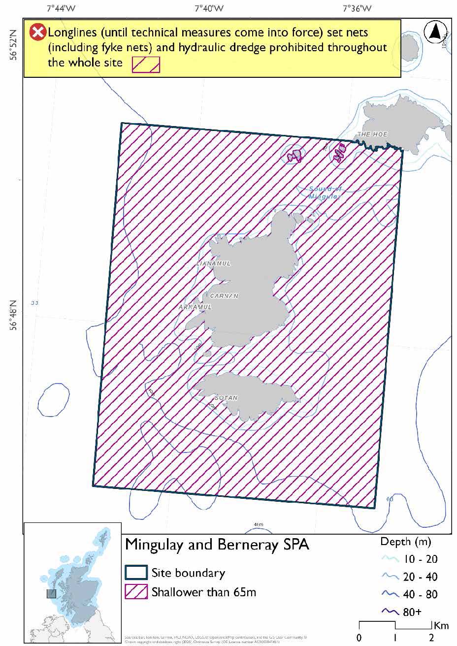
The proposed management measure for Mingulay and Berneray SPA is as follows:
Single Proposed Management Option*
- Full site closure to longlines (until technical measures come into force) and hydraulic dredge
- Set nets (including fyke nets) prohibited in areas down to 65m (covers full site based on presence and maximum dive depth for shag. As shag are present all year and this site is shallower than other protected features maximum dive depths these do not need considered)
Figure 73. Map of measures proposed
A full site level of protection from the specified gear has been identified as the only suitable option in enabling the achievement of the desired level of protection for the feature in question.
Overlapping site included in this consultation
This SPA overlaps with the Sea of the Hebrides NCMPA.
Rationale for developed measures
The basis for the proposed fisheries management measures for each site has been determined by the management advice for fishing activities provided by NatureScot, which can be found on their website or Sitelink as signposted throughout this document. The Fisheries Assessment for each site assesses the impacts from existing fishing activities on the protected features using the tests from the legislation relevant for the type of MPA being considered. The assessment outlines how the proposed measures address any impacts identified that could hinder the conservation objectives of the MPA.
14.8.6 Other fisheries management measures currently applying to this site
There are already management measures in place. An effort has been made to identify existing measures which affect each individual site or area, however the list may not be exhaustive. These measures are outlined below, and the proposals for further management being consulted on now are in addition to these existing measures:
- Fishing for sandeel is prohibited within the Scottish zone, which is defined as the sea adjacent to Scotland up to the 200 nautical miles limit
- Fishing for any species of sea fish with a creel or parlour creel is prohibited from 01 November till 31st March each year in part of the site
- Fishing with mobile/active gear prohibited from 1 March to 31 October each year in part of the site. This includes trawls, Danish seines or similar nets, purse seines, ring nets and dredges (not including suction dredges)
- Fishing for scallops permitted between 01 May and 24th August in part of the site
- Suction dredging is prohibited all year in part of the site
Other conservation measures can be found in section 7 of the CMA.
14.9 North Rona and Sula Sgeir SPA
14.9.1 Description and background
The North Rona and Sula Sgeir SPA lies in the North Atlantic approximately 65 km north of Lewis in the Outer Hebrides. The site encompasses the seabird breeding colonies on the islands of North Rona and Sula Sgeir, together with a marine extension of approximately 2 km that includes the seabed, water column and surface waters. This extension ensures that marine areas associated with the breeding colonies are included within the SPA.
The site comprises two remote islands with contrasting characteristics: North Rona, which is partly vegetated with submaritime grassland, and Sula Sgeir, a smaller, largely bare rocky stack. Both are dominated by steep cliffs and rocky coastlines, providing suitable nesting habitat for large seabird colonies. Their isolation and limited human disturbance contribute to their importance as breeding sites.
The SPA supports internationally important seabird populations, including Leach’s petrel and storm‑petrel, as well as significant numbers of northern gannet and common guillemot, and additional species such as fulmar, kittiwake, razorbill and puffin. The site regularly supports in excess of 20,000 seabirds, with total numbers around 130,000 individuals.
The surrounding marine environment is important for supporting the feeding and foraging requirements of these species. The inclusion of the seabed, water column and surface waters helps maintain the ecological processes and environmental conditions that underpin prey availability, enabling seabirds associated with the colonies.
Further information, including Conservation and Management Advice (CMA) can be found on Sitelink
Further information on MPAs, the wider network and protected areas management is available at Scottish Government MPA policy page.
14.9.2 Protected features
The North Rona and Sula Sgeir SPA is designated to protect:
- Fulmar;
- Gannet;
- Great black-backed gull;
- Guillemot;
- Kittiwake;
- Leach’s petrel;
- Puffin;
- Razorbill; and
- Storm petrel
The protected features of the North Rona and Sula Sgeir SPA are protected within the SPA throughout the year, irrespective of the season for which they qualified as a protected feature.
14.9.3 Conservation Objectives
The following protected features are in favourable condition at the North Rona and Sula Sgeir SPA: storm petrel and gannet. Therefore, the Conservation Objectives seek to maintain this condition.
The following protected features are in unfavourable condition at the North Rona and Sula Sgeir SPA: puffin, kittiwake, guillemot, great black-backed gull, Leach’s petrel, fulmar and razorbill. Therefore, the Conservation Objectives seek to restore this condition.
Additional details, including the Conservation Objectives, are provided in the Conservation and Management Advice document produced for this SPA and can be found on Sitelink.
14.9.4 Pressure from fishing activity
Accidental bycatch is a major direct threat: auks are prone to capture in surface nets, kittiwakes in surface gears, shags and gannets across multiple gear types, and fulmars in both longline and surface fisheries.
Species are also sensitive to prey depletion, whether driven by climate change or fisheries practices, which lowers body condition, breeding success, and chick survival. Loss of sandeels and other forage species is particularly critical, forcing birds to forage further or switch to less suitable prey.
Disturbance and displacement add further pressures. Kittiwakes, auks, gulls, and gannets may be displaced by marine developments and vessel activity, with guillemots and razorbills especially sensitive to visual and noise disturbance. Fulmars and storm petrels can desert nests if repeatedly disturbed during incubation. Increased turbidity from seabed disturbance further impairs foraging efficiency for water‑column feeders such as guillemots, razorbills, and gannets.
Additional details are provided in the Conservation and Management Advice document produced for this SPA (section 6) and can be found on Sitelink.
14.9.5 Fisheries management advice relevant to proposed fisheries management measures
NatureScot provides risk-based advice to help manage activities that may impact protected features and their Conservation Objectives. See section 2.3 for more detail. The CMA document also sets out the full fisheries management advice that has been summarised below for the management measures proposed:
Hydraulic gear
Remove or avoid pressures (removal of prey species and disturbance of prey-supporting habitat) associated with hydraulic fishing that has the potential to damage seabed habitat (in particular, sandeel habitat and herring spawning grounds) is recommended
Static gear (drift nets and bottom set nets including fyke nets)
Remove or avoid pressures (entanglement) associated with the use of all static nets. Spatial exclusion of all static nets in areas identified as being important for auks (guillemot, razorbills, puffins) and gannet (as identified from habitat and dive depth preferences) is recommended.
Pelagic gear
Pelagic fishing for herring/sprat may occur within or around the SPA. It is recommended that a principal objective of the management of the fishery should be ensuring that the fishing activity does not prevent or disrupt the availability of prey species i.e. it should be considered as part of a broader ecosystem-based approach to management of this fishery.
Longlining (not including jigging)
Long-lining (pelagic and demersal) may occur within or around the SPA(s). Current understanding is that long-line fisheries are largely restricted to offshore waters. Site-specific measures for long-lining are not currently considered appropriate due to the scale of the fishery, and the wide-spread interaction with seabirds. However, there is evidence of seabird bycatch in long-line (not jigging) fisheries therefore it is recommended this requires wider seas management measures.
For the SPAs advice has also been provided on maximum dive depth and seasonality for protected features of each site and can be found in the Fishing Activity Further Advice and Evidence document. Supplementary advice can also be found on NatureScot’s website.
14.9.6 Proposed fisheries management measures
NatureScot also provided amalgamated season advice for this site but individual seasonality for species has been used to develop consultation options.
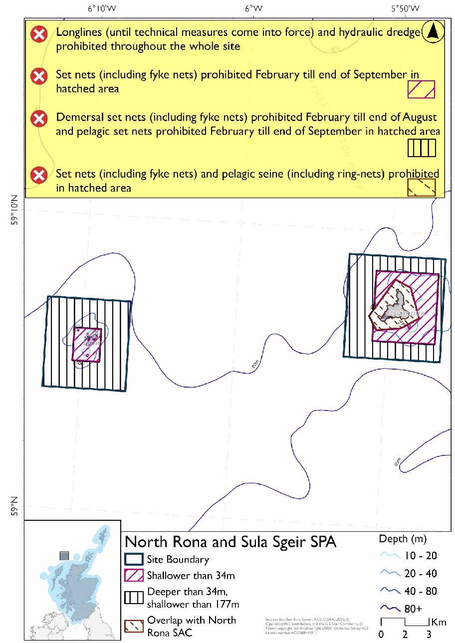
The proposed management measures for North Rona and Sula Sgeir SPA are as follows:
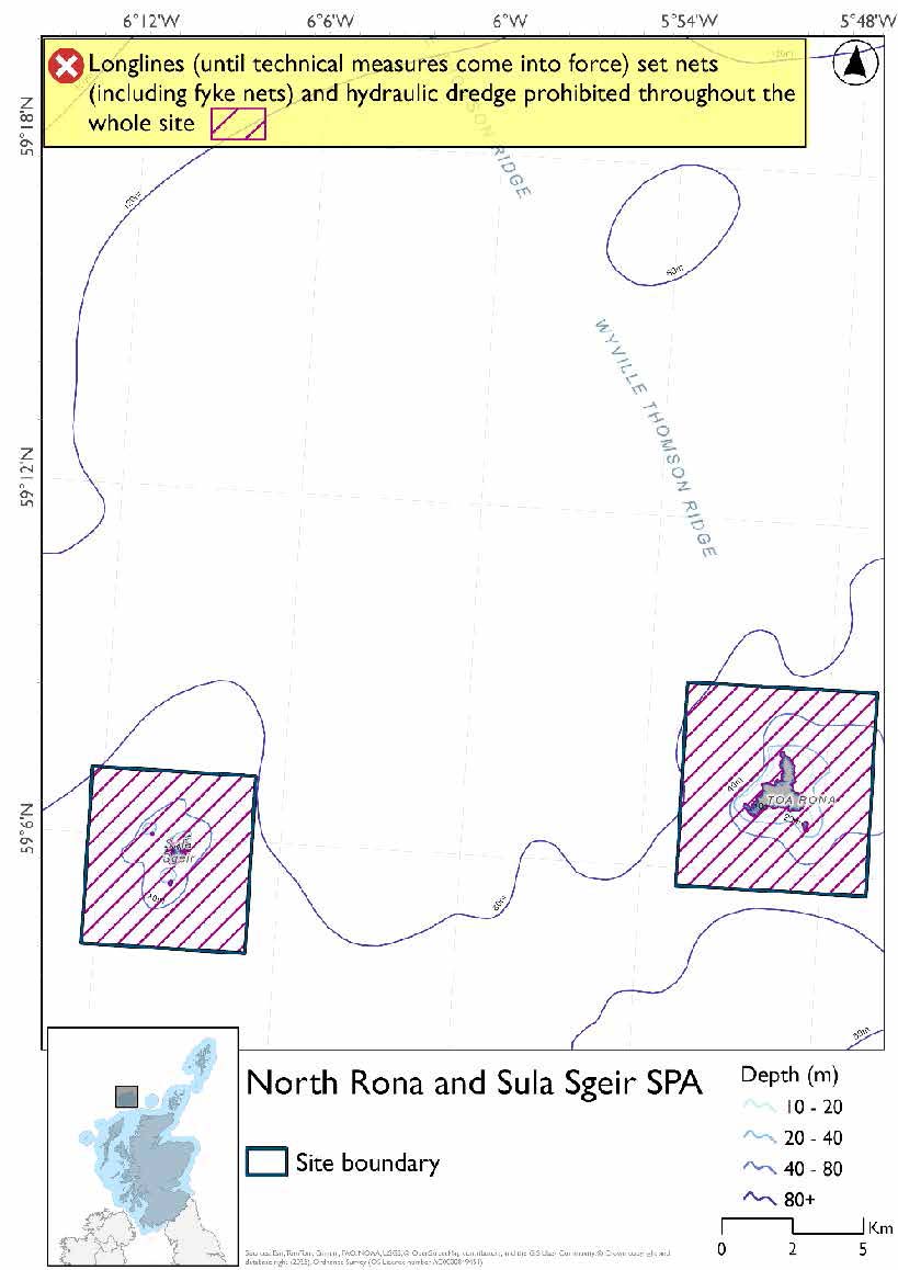
Option One
- Set nets (including fyke nets) prohibited February till end of September in areas shallower than 34m based on presence and maximum dive depth for gannet
- Demersal set nets (including fyke nets) prohibited February till end of August and pelagic set nets prohibited February till end of September based on presence of guillemot and gannet and maximum dive depth for guillemot in areas deeper than 34m but shallower than 177m
- Set nets (including fyke nets) and pelagic seines (including ring-nets) prohibited in part of the site that overlaps with the North Rona SAC
- Full site closure to longlines (until technical measures come into force) and hydraulic dredge
Figure 74. Map of measures proposed under option 1
Option Two*
- Full site closure to longlines (until technical measures come into force), set nets (including fyke nets) and hydraulic dredge
Figure 75. Map of measures proposed under option 2
*The measures for Option 2 proposals only come from gear types prohibited in non-overlapping areas. Overlapping restrictions may still apply from overlapping sites or areas dependent on the decisions taken for that site or area.
Overlapping site included in this consultation
This SPA overlaps with the North Rona SAC.
Rationale for developed measures
The basis for the proposed fisheries management measures for each site has been determined by the management advice for fishing activities provided by NatureScot, which can be found on their website or Sitelink as signposted throughout this document. The Fisheries Assessment for each site assesses the impacts from existing fishing activities on the protected features using the tests from the legislation relevant for the type of MPA being considered. The assessment outlines how the proposed measures address any impacts identified that could hinder the conservation objectives of the MPA.
14.9.7 Other fisheries management measures currently applying to this site
There are already management measures in place. An effort has been made to identify existing measures which affect each individual site or area, however the list may not be exhaustive. These measures are outlined below, and the proposals for further management being consulted on now are in addition to these existing measures:
- Fishing for sandeel is prohibited within the Scottish zone, which is defined as the sea adjacent to Scotland up to the 200 nautical miles limit
Other conservation measures can be found in section 7 of the CMA.
14.10 Seas off St Kilda SPA
14.10.1 Description and background
The Seas off St Kilda SPA lies in the North Atlantic, surrounding the St Kilda archipelago approximately 64 km west of the Outer Hebrides. Covering around 123,000 hectares, it is one of the largest marine SPAs in the UK and extends well beyond the immediate coastline to include extensive offshore waters.
The SPA encompasses a highly productive marine environment that supports internationally important seabird populations associated with St Kilda, one of Europe’s most significant seabird sites. The archipelago hosts the world’s largest colony of northern gannet and the largest puffin colony in the UK, alongside substantial populations of other seabirds.
The marine environment comprises deep Atlantic waters and oceanographic features that support abundant prey resources. These conditions underpin the feeding ecology of seabirds breeding at St Kilda, ensuring access to the food supply required to maintain their populations and breeding success. The combination of steep cliffs, sea stacks, and surrounding waters makes St Kilda one of the most important seabird sites in Europe.
Further information, including Conservation and Management Advice (CMA) can be found on Sitelink
As this SPA overlaps into the offshore region there is more detailed additional information on JNCCs website.
Further information on MPAs, the wider network and protected areas management is available at Scottish Government MPA policy page.
14.10.2 Protected features
The Seas off St Kilda SPA is designated to protect:
- Fulmar;
- Gannet;
- Guillemot;
- Puffin; and
- Storm petrel
The protected features of the Seas off St Kilda SPA are protected within the relevant SPA throughout the year, irrespective of the season for which they qualified as a protected feature.
14.10.3 Conservation Objectives
Storm petrel and gannets are in favourable condition in the Seas off St Kilda SPA. Consequently, the Conservation Objectives for storm petrel and gannets seek to maintain this condition.
Puffin, guillemot and fulmar are in unfavourable condition in the Seas off St Kilda SPA. The Conservation Objectives therefore seek to restore this condition.
Additional details, including the Conservation Objectives, are provided in the Conservation and Management Advice document produced for this SPA and can be found on Sitelink.
14.10.4 Pressure from fishing activity
Fulmars, gannets, guillemots, puffins, and storm petrels all face pressures from human and fishing activities. Accidental bycatch is a major direct threat: fulmars are heavily impacted in longline and surface fisheries, gannets are sensitive to both surface and pelagic gears, and auks (guillemots and puffins) are prone to capture in surface nets. Storm petrels have recorded entanglement incidents, though their sensitivity to bycatch in UK waters is considered low.
All protected features are also sensitive to prey depletion, whether driven by climate change or fisheries practices, which lowers body condition, breeding success, and chick survival. Loss of sandeels and other forage species is particularly critical, forcing birds to forage further or switch to less suitable prey, amplifying energetic costs and exposure to other risks.
Disturbance and displacement add further pressures. Fulmars may desert nests if repeatedly disturbed during incubation, while gannets, auks, and storm petrels can be displaced vessel activity. Guillemots and razorbills are especially sensitive to visual and noise disturbance. Increased turbidity from seabed disturbance further impairs foraging efficiency for water‑column feeders such as guillemots, puffins, and gannets.
Additional details are provided in the Conservation and Management Advice document produced for this SPA (section 6) and can be found on Sitelink.
Other resources include:
- The Feature Activity Sensitivity Tool (FeAST) which allows users to investigate the sensitivity of marine features (habitats, species, geology and landforms) in Scotland's seas, to pressures arising from human activities;
- Fisheries Guidance Notes which provide summaries of evidence on the interaction between fishing gears and specific habitats and species.
14.10.5 Fisheries management advice relevant to proposed fisheries management measures
NatureScot provides risk-based advice to help manage activities that may impact protected features and their Conservation Objectives. See section 2.3 for more detail. The CMA document also sets out the full fisheries management advice that has been summarised below for the management measures proposed:
Hydraulic gear
Remove or avoid pressures (removal of prey species and disturbance of prey-supporting habitat) associated with hydraulic fishing that has the potential to damage seabed habitat (in particular, sandeel habitat, herring spawning grounds) is recommended.
Static gear (drift nets and bottom set nets including fyke nets)
Remove or avoid pressures (entanglement) associated with the use of all static nets. Spatial exclusion of all static nets in areas identified as being important for auks (as identified from habitat and dive depth preferences) is recommended.
Pelagic gear
Pelagic fishing for herring/sprat may occur within or around the SPA. It is recommended that a principal objective of the management of the fishery should be ensuring that the fishing activity does not prevent or disrupt the availability of prey species i.e. it should be considered as part of a broader ecosystem-based approach to management of this fishery.
Longlining (not including jigging)
Long-lining (pelagic and demersal) may occur within or around the SPA(s). Current understanding is that long-line fisheries are largely restricted to offshore waters. Site-specific measures for long-lining are not currently considered appropriate due to the scale of the fishery, and the wide-spread interaction with seabirds. However, there is evidence of seabird bycatch in long-line (not jigging) fisheries therefore it is recommended this requires wider seas management measures.
Reduce or limit pressures (bycatch) associated with any pelagic or bottom-set long-line fishing is recommended, where wider seas measures overlap with Seas off St Kilda SPA.
For the SPAs advice has also been provided on maximum dive depth and seasonality for protected features of each site and can be found in the Fishing Activity Further Advice and Evidence document. Supplementary advice can also be found on NatureScot’s website.
14.10.6 Proposed fisheries management measures
NatureScot also provided amalgamated season advice for this site but individual seasonality for species has been used to develop consultation options.
The proposed management measures for Seas off St Kilda SPA are as follows:
Option One
- Demersal set nets (including fyke nets) prohibited between February and end of August and pelagic set nets prohibited February till end of September in areas down to 177m based on presence of guillemot and gannet and maximum dive depth for guillemot
- Pelagic set nets prohibited February till end of September in areas deeper than 177m based on presence of guillemot and gannet
- Full site closure to longlines (until technical measures come into force) and hydraulic dredge
Figure 76. Map of measures proposed under option 1
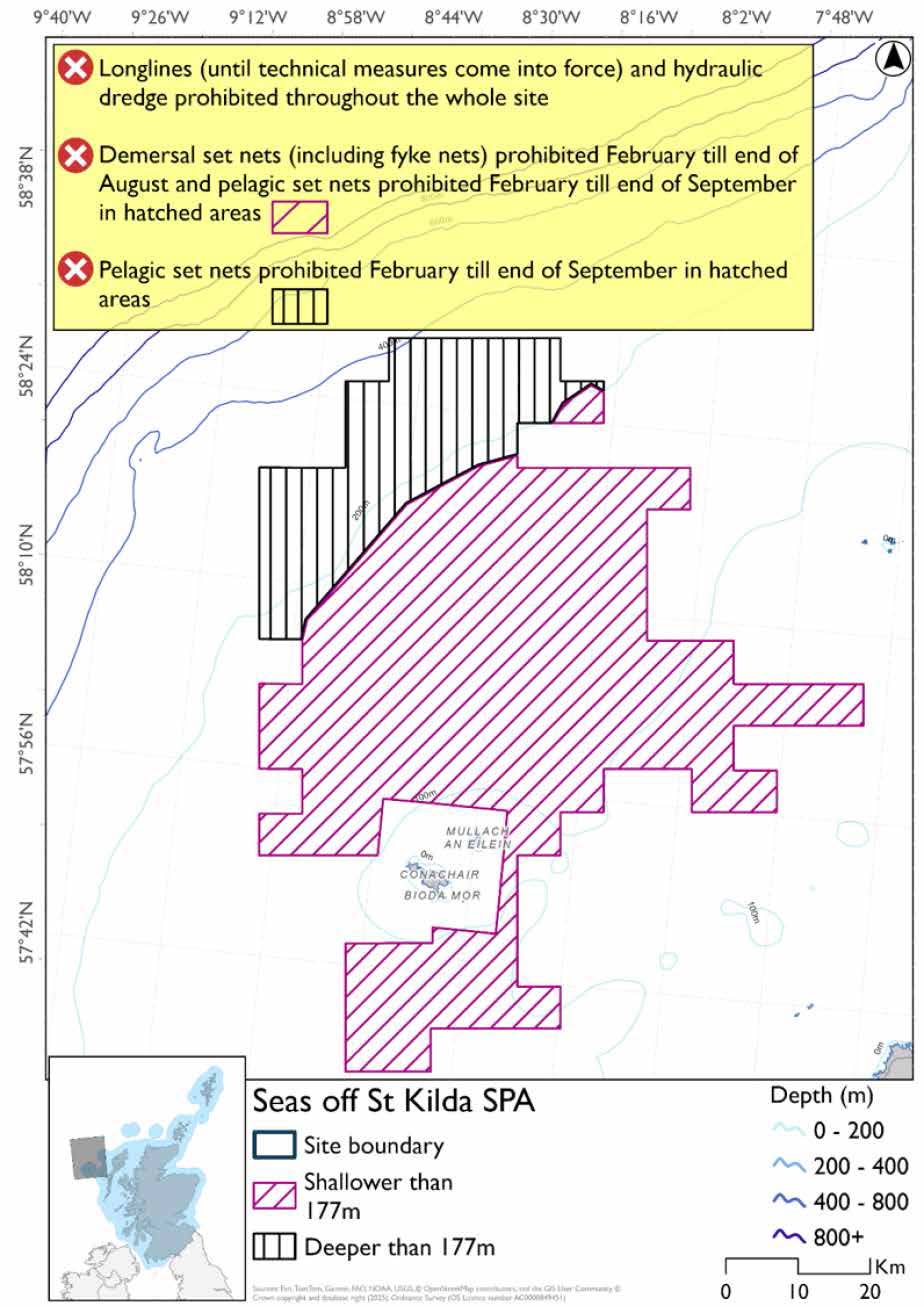
Option Two
- Full site closure to longlines (until technical measures come into force), set nets (including fyke nets) and hydraulic dredge
Figure 77. Map of measures proposed under option 2
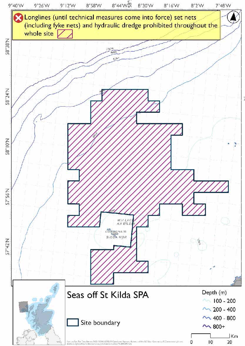
Rationale for developed measures
The basis for the proposed fisheries management measures for each site has been determined by the management advice for fishing activities provided by NatureScot, which can be found on their website or Sitelink as signposted throughout this document. The Fisheries Assessment for each site assesses the impacts from existing fishing activities on the protected features using the tests from the legislation relevant for the type of MPA being considered. The assessment outlines how the proposed measures address any impacts identified that could hinder the conservation objectives of the MPA.
14.10.7 Other fisheries management measures currently applying to this site
There are already management measures in place. An effort has been made to identify existing measures which affect each individual site or area, however the list may not be exhaustive. These measures are outlined below, and the proposals for further management being consulted on now are in addition to these existing measures:
- Fishing for sandeel is prohibited within the Scottish zone, which is defined as the sea adjacent to Scotland up to the 200 nautical miles limit
- Bottom set gillnet, entangling net and trammel net prohibited at any position where the charted depth is greater than 200 m in parts of the site
Other conservation measures can be found in section 7 of the CMA.
14.11 Shiant Isles SPA
14.11.1 Description and background
The Shiant Isles SPA lies in the Minch between Lewis and Skye in the Outer Hebrides. The site comprises a small group of islands, including Garbh Eilean, Eilean an Tighe and Eilean Mhuire, together with surrounding coastal waters, and is designated for its internationally important seabird populations.
The islands are characterised by steep basalt cliffs and grassy slopes, which provide extensive nesting habitat for seabirds. These cliffs and coastal slopes support breeding colonies in ledges, crevices and burrows, and the site’s relative isolation and low levels of disturbance contribute to its suitability for large seabird populations.
The SPA supports internationally significant seabird populations, notably a very large colony of puffin, as well as species such as guillemot, razorbill, kittiwake and fulmar. These species breed on the islands and utilise the surrounding marine environment during the breeding season.
The SPA includes a marine extension, encompassing the seabed, water column and surface waters, which ensures that marine areas associated with the colonies are included within the site. This marine component supports the feeding and foraging requirements of seabirds, maintaining the ecological processes and environmental conditions that underpin prey availability and enable birds to utilise adjacent waters during the breeding season.
Further information, including Conservation and Management Advice (CMA) can be found on Sitelink.
Further information on MPAs, the wider network and protected areas management is available at Scottish Government MPA policy page.
14.11.2 Protected features
The Shiant Isles SPA has been designated to protect:
- Fulmar
- Greenland barnacle goose;
- Guillemot;
- Kittiwake;
- Puffin;
- Razorbill; and
- Shag
Greenland barnacle goose is not discussed further as they are not a protected feature for which fisheries management measures are required.
The protected features of the Shiant Isles SPA are protected within the SPA throughout the year, irrespective of the season for which they qualified as a protected feature.
14.11.3 Conservation Objectives
The following protected features are in favourable condition at the Shiant Isles SPA: puffin and razorbill. Therefore, the Conservation Objectives seek to maintain this condition.
The following protected features are in unfavourable condition at the Shiant Isles SPA: kittiwake, guillemot, shag and fulmar. Therefore, the Conservation Objectives seek to restore this condition.
Additional details, including the Conservation Objectives, are provided in the Conservation and Management Advice document produced for this SPA and can be found on Sitelink.
14.11.4 Pressure from fishing activity
Kittiwakes, auks (puffins, guillemots, razorbills), shags, and fulmars all face pressures from human and fishing activities. Accidental bycatch is a major direct threat: kittiwakes are sensitive to surface gears, auks are prone to capture in nets, shags are sensitive across surface, pelagic, and near‑seabed gears, and fulmars are heavily impacted in longline and surface fisheries.
All protected features are also sensitive to prey depletion, whether driven by climate change or fisheries practices, which lowers body condition, breeding success, and chick survival. Loss of sandeels and other forage species is particularly critical, forcing birds to forage further or switch to less suitable prey, amplifying energetic costs and exposure to other risks.
Disturbance and displacement add further pressures. Kittiwakes, auks, shags, and fulmars may be displaced by vessel activity. Guillemots and razorbills are especially sensitive to visual and noise disturbance, and fulmars can desert nests if repeatedly disturbed during incubation. Increased turbidity from seabed disturbance further impairs foraging efficiency for water‑column feeders such as guillemots, razorbills, and shags.
Additional details are provided in the Conservation and Management Advice document produced for this SPA (section 6) and can be found on Sitelink.
Other resources include:
- The Feature Activity Sensitivity Tool (FeAST) which allows users to investigate the sensitivity of marine features (habitats, species, geology and landforms) in Scotland's seas, to pressures arising from human activities;
- Fisheries Guidance Notes which provide summaries of evidence on the interaction between fishing gears and specific habitats and species.
14.11.5 Fisheries management advice relevant to proposed fisheries management measures
NatureScot provides risk-based advice to help manage activities that may impact protected features and their Conservation Objectives. See section 2.3 for more detail. The CMA document also sets out the full fisheries management advice that has been summarised below for the management measures proposed:
Hydraulic gear
Remove or avoid pressures (removal of prey species and disturbance of prey-supporting habitat) associated with hydraulic fishing that has the potential to damage seabed habitat (in particular, sandeel habitat, herring spawning grounds) is recommended.
Static gear (drift nets and bottom set nets including fyke nets)
Remove or avoid pressures (entanglement) associated with the use of all static nets. Spatial exclusion of all static nets in areas identified as being important for auks and shags (as identified from habitat and dive depth preferences) is recommended.
Pelagic gear
Pelagic fishing for herring/sprat may occur within or around the SPA. It is recommended that a principal objective of the management of the fishery should be ensuring that the fishing activity does not prevent or disrupt the availability of prey species i.e. it should be considered as part of a broader ecosystem-based approach to management of this fishery.
Longlining (not including jigging)
Long-lining (pelagic and demersal) may occur within or around the SPA(s). Current understanding is that long-line fisheries are largely restricted to offshore waters. Site-specific measures for long-lining are not currently considered appropriate due to the scale of the fishery, and the wide-spread interaction with seabirds. However, there is evidence of seabird bycatch in long-line (not jigging) fisheries therefore it is recommended this requires wider seas management measures.
For the SPAs advice has also been provided on maximum dive depth and seasonality for protected features of each site and can be found in the Fishing Activity Further Advice and Evidence document. Supplementary advice can also be found on NatureScot’s website.
14.11.6 Proposed fisheries management measures
NatureScot also provided amalgamated season advice for this site but individual seasonality for species has been used to develop consultation options.
The proposed management measures for Shiant Isles SPA are as follows:
Option One
- Set nets (including fyke nets) prohibited in areas shallower than 64.5m based on presence and maximum dive depth for shag
- Demersal set nets (including fyke nets) prohibited from February till end of August and pelagic set nets prohibited in areas deeper than 64.5m but shallower than 177m based on presence of guillemot and shag and maximum dive depth of guillemot.
- Full site closure to longlines (until technical measures come into force) and hydraulic dredge
Figure 78. Map of measures proposed under option 1
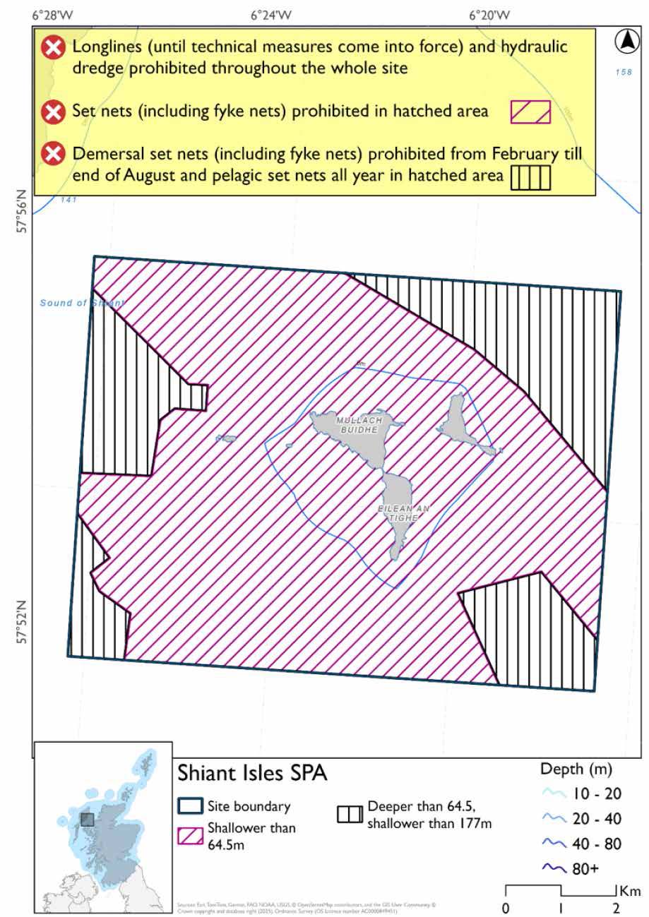
Option Two
- Full site closure to longlines (until technical measures come into force), set nets (including fyke nets) and hydraulic dredge
Figure 79. Map of measures proposed under option 2
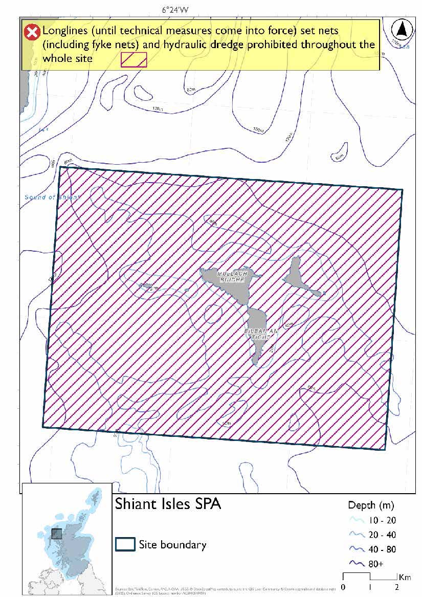
Overlapping site included in this consultation
This SPA overlaps with the Inner Hebrides and the Minches SAC.
Rationale for developed measures
The basis for the proposed fisheries management measures for each site has been determined by the management advice for fishing activities provided by NatureScot, which can be found on their website or Sitelink as signposted throughout this document. The Fisheries Assessment for each site assesses the impacts from existing fishing activities on the protected features using the tests from the legislation relevant for the type of MPA being considered. The assessment outlines how the proposed measures address any impacts identified that could hinder the conservation objectives of the MPA.
14.11.7 Other fisheries management measures currently applying to this site
There are already management measures in place. An effort has been made to identify existing measures which affect each individual site or area, however the list may not be exhaustive. These measures are outlined below, and the proposals for further management being consulted on now are in addition to these existing measures:
- Fishing for sandeel is prohibited within the Scottish zone, which is defined as the sea adjacent to Scotland up to the 200 nautical miles limit
Other conservation measures can be found in section 7 of the CMA.
14.12 St Kilda SPA
14.12.1 Description and background
The St Kilda SPA lies in the North Atlantic approximately 65–70 km west of the Outer Hebrides and includes the islands of Hirta, Dun, Soay and Boreray. The site is characterised by steep, precipitous cliffs and rocky coastlines, with cliffs rising to over 400m, together with areas of maritime grassland and heath. The SPA forms part of the wider St Kilda archipelago, one of the most important seabird breeding areas in the North Atlantic.
These cliffs and coastal slopes provide extensive nesting habitat for seabirds, supporting one of the largest concentrations of breeding seabirds in the UK and wider North Atlantic, with total numbers exceeding 600,000 individuals. The scale, inaccessibility and isolation of the site make it particularly suitable for large breeding colonies.
The SPA includes a marine extension of approximately 4 km, encompassing the seabed, water column and surface waters, ensuring that marine areas associated with the breeding colonies are included within the site. This marine component supports the feeding and foraging requirements of seabirds, maintaining the ecological processes and environmental conditions that underpin prey availability and enable birds to utilise surrounding waters during the breeding season.
The SPA supports internationally significant seabird populations. St Kilda holds the world’s largest gannet colony and the UK’s largest puffin colony, making it a site of global ornithological importance.
Further information, including Conservation and Management Advice (CMA) can be found on Sitelink.
Further information on MPAs, the wider network and protected areas management is available at Scottish Government MPA policy page.
14.12.2 Protected features
The St Kilda SPA is designated to protect:
- Fulmar;
- Gannet;
- Great skua;
- Guillemot;
- Kittiwake;
- Leach’s petrel;
- Manx shearwater;
- Puffin;
- Razorbill; and
- Storm petrel
The protected features of the St Kilda SPA are protected within the SPA throughout the year, irrespective of the season for which they qualified as a protected feature.
14.12.3 Conservation Objectives
Storm petrel, Leach’s petrel, and gannet are in favourable condition at St Kilda SPA. Therefore, the Conservation Objectives for these protected features seek to maintain this condition within the St Kilda SPA.
Puffin, kittiwake, guillemot, fulmar, great skua, Manx shearwater and razorbill are in unfavourable condition at St Kilda SPA. Therefore, the Conservation Objectives for these protected features seek to restore this condition within the St Kilda SPA.
Additional details, including the Conservation Objectives, are provided in the Conservation and Management Advice document produced for this SPA and can be found on Sitelink.
14.12.4 Pressure from fishing activity
Auks, kittiwakes, storm petrels, skuas, shearwaters, fulmars, and gannets all face pressures from human and fishing activities. Accidental bycatch is a major direct threat: auks are prone to capture in surface nets, kittiwakes in surface gears, skuas in longline fisheries, shearwaters in longline and gillnet fisheries, fulmars in both longline and surface gears, and gannets in surface and pelagic gears.
All protected features are also sensitive to prey depletion, whether driven by climate change or fisheries practices, which lowers body condition, breeding success, and chick survival. Loss of sandeels and other forage species is particularly critical, with declines linked to reduced breeding success in kittiwakes, auks, fulmars, skuas, and shearwaters.
Disturbance and displacement add further pressures. Kittiwakes, auks, gannets, and fulmars may be displaced by vessel activity, with guillemots and razorbills especially sensitive to visual and noise disturbance. Fulmars can desert nests if repeatedly disturbed during incubation. Skuas are sensitive to disturbance at breeding colonies, leading to egg failure, and shearwaters can be disorientated by artificial light, increasing collision risk. Increased turbidity from seabed disturbance further impairs foraging efficiency for water‑column feeders such as auks, gannets, and shearwaters.
Additional details are provided in the Conservation and Management Advice document produced for this SPA (section 6) and can be found on Sitelink.
Other resources include:
- The Feature Activity Sensitivity Tool (FeAST) which allows users to investigate the sensitivity of marine features (habitats, species, geology and landforms) in Scotland's seas, to pressures arising from human activities;
- Fisheries Guidance Notes which provide summaries of evidence on the interaction between fishing gears and specific habitats and species.
14.12.5 Fisheries management advice relevant to proposed fisheries management measures
NatureScot provides risk-based advice to help manage activities that may impact protected features and their Conservation Objectives. See section 2.3 for more detail. The CMA document also sets out the full fisheries management advice that has been summarised below for the management measures proposed:
Hydraulic gear
Remove or avoid pressures (removal of prey species and disturbance of prey-supporting habitat) associated with hydraulic fishing that has the potential to damage seabed habitat (in particular, sandeel habitat, herring spawning grounds) is recommended.
Static gear (drift nets and bottom set nets including fyke nets)
Remove or avoid entanglement pressures associated with the use of all static nets. Spatial exclusion of all static nets in areas identified as being important for auks (guillemot, razorbills, puffins) is recommended.
Pelagic gear
Pelagic fishing for herring/sprat may occur within or around the SPA. It is recommended that a principal objective of the management of the fishery should be ensuring that the fishing activity does not prevent or
disrupt the availability of prey species i.e. it should be considered as part of a broader ecosystem-based approach to management of this fishery.
Longlining (not including jigging)
Long-lining (pelagic and demersal) may occur within or around the SPA(s). Current understanding is that long-line fisheries are largely restricted to offshore waters. Site-specific measures for long-lining are not currently considered appropriate due to the scale of the fishery, and the wide-spread interaction with seabirds. However, there is evidence of seabird bycatch in long-line (not jigging) fisheries therefore it is recommended this requires wider seas management measures.
For the SPAs advice has also been provided on maximum dive depth and seasonality for protected features of each site and can be found in the Fishing Activity Further Advice and Evidence document. Supplementary advice can also be found on NatureScot’s website.
14.12.6 Proposed fisheries management measures
NatureScot also provided amalgamated season advice for this site but individual seasonality for species has been used to develop consultation options.
The proposed management measures for St Kilda SPA are as follows:
Option One
- Demersal set nets (including fyke nets) prohibited February till end of August and pelagic set nets prohibited February till mid-October in areas shallower than 177m, based on presence of guillemot and gannet and maximum dive depth of guillemot
- Set nets (including fyke nets) already prohibited in overlapping area with the St Kilda SAC
- Full site closure to longlines (until technical measures come into force) and hydraulic dredge (hydraulic dredge already prohibited in overlap with St Kilda SAC)
Figure 80. Map of measures proposed under option 1
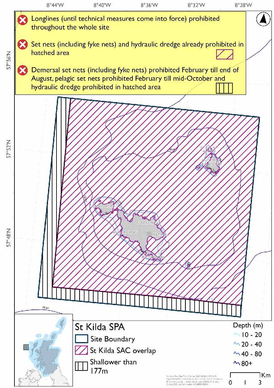
Option Two
- Full site closure to longlines (until technical measures come into force), set nets (including fyke nets) and hydraulic dredge
Figure 81. Map of measures proposed under option 2
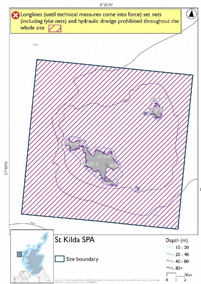
Rationale for developed measures
The basis for the proposed fisheries management measures for each site has been determined by the management advice for fishing activities provided by NatureScot, which can be found on their website or Sitelink as signposted throughout this document. The Fisheries Assessment for each site assesses the impacts from existing fishing activities on the protected features using the tests from the legislation relevant for the type of MPA being considered. The assessment outlines how the proposed measures address any impacts identified that could hinder the conservation objectives of the MPA.
14.12.7 Other fisheries management measures currently applying to this site
There are already management measures in place. An effort has been made to identify existing measures which affect each individual site or area, however the list may not be exhaustive. These measures are outlined below, and the proposals for further management being consulted on now are in addition to these existing measures:
- Fishing for sandeel is prohibited within the Scottish zone, which is defined as the sea adjacent to Scotland up to the 200 nautical miles limit
- Fishing for sea fish with a dredge, beam trawl, demersal trawl, demersal seine net or set net is prohibited across the majority site
Other conservation measures can be found in section 7 of the CMA.
14.13 West Coast of the Outer Hebrides SPA
14.13.1 Description and background
The West Coast of the Outer Hebrides SPA extends along the Atlantic‑facing coast of the Outer Hebrides, from the north of Harris to Sandray in the south. The site comprises extensive inshore waters and coastal habitats, forming part of a large marine SPA designated for its importance to seabirds and waterfowl.
The coastline includes a combination of steep rocky shores and cliffs, together with extensive sandy bays and machair systems. Offshore, the seabed is generally shallow, with sandy and gravelly sediments and areas of exposed bedrock, and depths rarely exceeding 30 m close to the coast. These inshore waters support diverse marine communities and provide productive conditions for birds associated with the site.
The SPA supports internationally important bird populations, particularly non‑breeding waterfowl and divers, including great northern diver, black‑throated diver, red‑throated diver and Slavonian grebe, as well as migratory species such as common eider, long‑tailed duck and red‑breasted merganser. The site also provides important foraging habitat for breeding red‑throated divers associated with nearby islands. This diversity makes the site one of the most ecologically valuable stretches of coastline in Scotland.
The SPA encompasses shallow coastal waters and nearshore marine habitats that support key ecological processes and provide feeding and supporting habitat for these species. The productive nature of these waters underpins prey availability and enables birds to utilise the area for feeding, resting and other essential behaviours throughout the year.
Further information, including Conservation and Management Advice (CMA) can be found on Sitelink.
Further information on MPAs, the wider network and protected areas management is available at Scottish Government MPA policy page.
14.13.2 Protected features
The West Coast of the Outer Hebrides SPA is designated to protect:
- Black-throated diver;
- Eider;
- Great northern diver;
- Long-tailed duck;
- Red-breasted merganser;
- Red-throated diver; and
- Slavonian grebe
The protected features of the West Coast of the Outer Hebrides SPA are protected within the SPA throughout the year, irrespective of the season for which they qualified as a protected feature.
14.13.3 Conservation Objectives
All protected features are in favourable condition at the West Coast of the Outer Hebrides SPA. Therefore, the Conservation Objectives for the West Coast of the Outer Hebrides SPA seek to maintain this condition.
Additional details, including the Conservation Objectives, are provided in the Conservation and Management Advice document produced for this SPA and can be found on Sitelink.
14.13.4 Pressure from fishing activity
Divers (great northern, black‑throated, and red‑throated), Slavonian grebes, eiders, long‑tailed ducks, and red‑breasted mergansers can all face pressures from fishing activities. Accidental bycatch and entanglement are major direct threats across all species, with divers, grebes, eiders, ducks, and mergansers all recorded as sensitive to capture in nets. These interactions cause immediate mortality and reduce survival, particularly during sensitive periods such as moulting.
All species are also sensitive to prey depletion and habitat impacts. Loss of prey resources, whether through overfishing or degradation of prey‑supporting habitats, reduces body condition, breeding success, and survival. Eiders are particularly dependent on bivalves and show limited ability to switch prey when mussel and cockle numbers decline, while divers and grebes are sensitive to reductions in fish availability.
Disturbance and displacement add further pressures. Divers, grebes, eiders, ducks, and mergansers all show sensitivity to vessel activity and marine developments, often taking evasive action or being displaced from feeding areas. Visual and noise disturbance from vessels further reduces foraging efficiency, while changes in water clarity from dredging impair prey detection for grebes and divers.
Additional details are provided in the Conservation and Management Advice document produced for this SPA (section 6) and can be found on Sitelink.
Other resources include:
- The Feature Activity Sensitivity Tool (FeAST) which allows users to investigate the sensitivity of marine features (habitats, species, geology and landforms) in Scotland's seas, to pressures arising from human activities;
- Fisheries Guidance Notes which provide summaries of evidence on the interaction between fishing gears and specific habitats and species.
14.13.5 Fisheries management advice relevant to proposed fisheries management measures
NatureScot provides risk-based advice to help manage activities that may impact protected features and their Conservation Objectives. See section 2.3 for more detail. The CMA document also sets out the full fisheries management advice that has been summarised below for the management measures proposed:
Hydraulic gear
Remove or avoid pressures (removal of prey species and disturbance of prey-supporting habitat) associated with hydraulic fishing that has the potential to damage seabed habitat (in particular, sandeel habitat, herring spawning grounds) is recommended.
Static gear (drift nets and bottom set nets including fyke nets)
Remove or avoid pressures (entanglement) associated with the use of all static nets. Spatial exclusion of static nets in areas identified as being important for divers and grebes (as identified from habitat and dive depth preferences) between August and May each year is recommended. Remove or avoid pressures (entanglement) associated with the use of all static nets. Spatial exclusion of static nets in areas identified as being important for red-breasted merganser (as identified from habitat and dive depth preferences) is recommended.
Red-throated diver. Remove or avoid pressures (entanglement) associated with all static nets (whether bottom set or in the water column). Spatial exclusion of static nets in areas identified as being important for red-throated diver (as identified from habitat and dive depth preferences) between April and mid-September each year is recommended.
Eider and long-tailed duck. Remove or avoid pressures (entanglement) associated with the use of all static nets. Spatial exclusion of static nets in areas identified as being important for long-tailed duck (as identified from habitat and dive depth preferences) between mid-September and May each year is recommended. Remove or avoid pressures (entanglement) associated with the use of all static nets. Spatial exclusion of static nets in areas identified as being important for eider (as identified from habitat and dive depth preferences) is recommended.
Pelagic gear
Pelagic fishing for herring/sprat may occur within or around the SPA. It is recommended that a principal objective of the management of the fishery should be ensuring that the fishing activity does not prevent or disrupt the availability of prey species i.e. it should be considered as part of a broader ecosystem-based approach to management of this fishery.
For the SPAs advice has also been provided on maximum dive depth and seasonality for protected features of each site and can be found in the Fishing Activity Further Advice and Evidence document. Supplementary advice can also be found on NatureScot’s website.
14.13.6 Proposed fisheries management measures
The proposed management measures for West Coast of the Outer Hebrides SPA are as follows:
Option One*
- Set nets (including fyke nets) prohibited in areas down to 60m based on presence and maximum dive depth for eider.
- Pelagic set nets prohibited in areas deeper than 60m based on presence of all protected features
- Set nets (including fyke nets) and pelagic seine (including ring-nets) prohibited in overlapping areas with the Monach Isles NCMPA/Monach Islands SAC and the Sound of Barra SAC
- Full site closure hydraulic dredge
Figure 82. Map of measures proposed under option 1
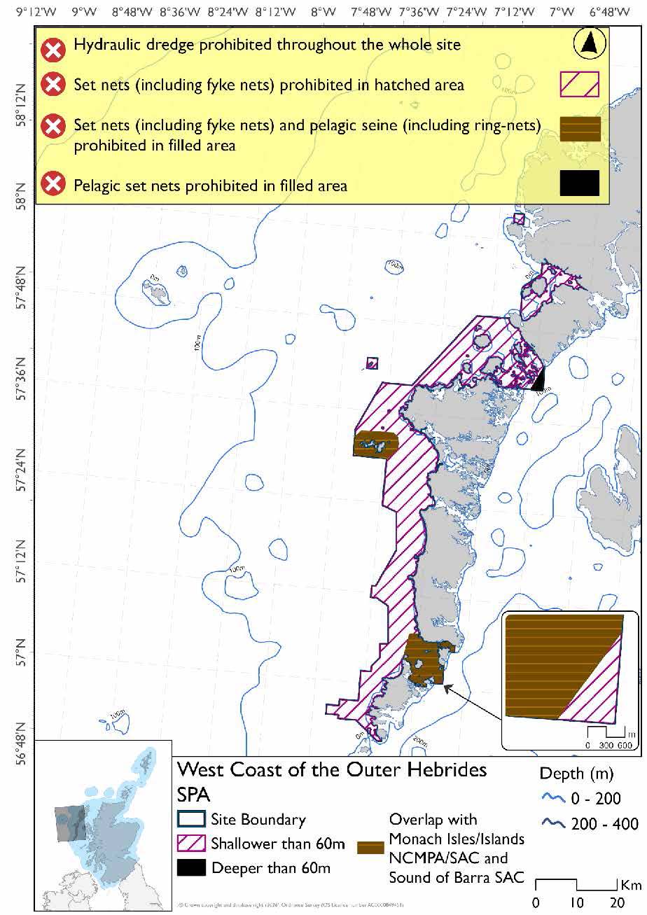
*This site will have other demersal mobile measures that may apply from the overlapping portions with the proposed PMF management areas that aren’t shown on the map for this option. The demersal mobile measures for Sound of Barra SAC will be over the south-eastern orange overlapping portion shown above.
- The Sound of Barra SAC and proposed PMF management areas (shown in below section) would prohibit all demersal mobile gear in the overlapping areas.
Please check the Option 1 or single management overlapping area maps to see proposed demersal mobile measures under Option 1.
Option Two*
- Full site closure to set nets (including fyke nets) and hydraulic dredge
Figure 83. Map of measures proposed under option 2
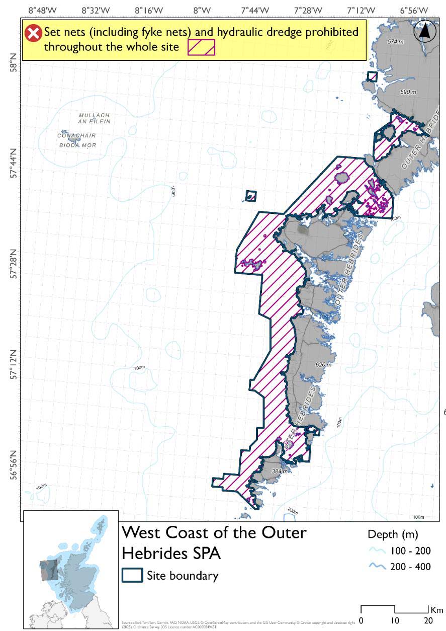
*The measures for Option 2 proposals only come from gear types prohibited in non-overlapping areas. Overlapping restrictions may still apply from overlapping sites or areas dependent on the decisions taken for that site or area.
Overlapping sites and areas included in this consultation
This SPA overlaps with the:
- Monach Isles and islands NCMPA & SAC
- Sound of Barra SAC
- Sea of the Hebrides NCMPA
- Inner Hebrides and the Minches SAC
- Pabaigh, South (Sound of Harris) proposed PMF management area
- Pabaigh, South-East (Sound of Harris) proposed PMF management area
- Aird an t-Sruith (Sound of Harris) proposed PMF management area
- Berneray (East) Sound of Harris proposed PMF management area
- Boreray and Berneray (North Uist) proposed PMF management area
- Easaigh and Ceilegraigh (Sound of Harris) proposed PMF management area
- Rangas, Bhotarsaigh and Sursaigh (North Uist) proposed PMF management area
- Sound of Taransay and West Loch Tarbert (Harris) proposed PMF management area
Rationale for developed measures
The basis for the proposed fisheries management measures for each site has been determined by the management advice for fishing activities provided by NatureScot, which can be found on their website or Sitelink as signposted throughout this document. The Fisheries Assessment for each site assesses the impacts from existing fishing activities on the protected features using the tests from the legislation relevant for the type of MPA being considered. The assessment outlines how the proposed measures address any impacts identified that could hinder the conservation objectives of the MPA.
14.13.7 Other fisheries management measures currently applying to this site
There are already management measures in place. An effort has been made to identify existing measures which affect each individual site or area, however the list may not be exhaustive. These measures are outlined below, and the proposals for further management being consulted on now are in addition to these existing measures:
- Fishing for sandeel is prohibited within the Scottish zone, which is defined as the sea adjacent to Scotland up to the 200 nautical miles limit
- Fishing for any species of sea fish with a creel or parlour creel is prohibited from 01 November till 31st March each year in part of the site
- Fishing with mobile/active gear prohibited from 1 March to 31 October each year in part of the site. This includes trawls, Danish seines or similar nets, purse seines, ring nets and dredges (not including suction dredges)
- Fishing for scallops permitted between 01 May and 24th August in part of the site
- Suction dredging is prohibited all year in part of the site
Other conservation measures can be found in section 7 of the CMA.
Contact
Email: marine_biodiversity@gov.scot