
Fisheries Management Measures within Scottish Inshore Marine Protected Areas (MPAs) and Proposed Priority Marine Feature (PMF) Management Areas - Site and Area Proposal Document
This document describes the process, justification and evidence used to develop site and area specific fisheries management measures. It outlines key information for each site and area including their features, and risks of potential pressures.

25. Proposed PMF management areas in the West Highlands marine region
25.1 Ascrib Islands (Skye)
25.1.1 Description and background*
Ascrib Islands (Skye) proposed PMF management area covers the waters surrounding the Ascrib Islands to the Northeast of Skye. This area has been selected to protect:
- Maerl beds; and
- Northern sea fan and sponge communities
*This proposed PMF management area overlaps with the Ascrib, Isay and Dunvegan and Inner Hebrides and the Minches SACs.
25.1.2 Fisheries management measures proposed
PMF management areas will be closed to demersal trawls and seines, beam trawls, mechanical dredges, and hydraulic dredges. This is because the features present in these areas are sensitive to these gear types.
This PMF management area overlaps with management measures being consulted on for Ascrib, Isay and Dunvegan and Inner Hebrides and the Minches SACs for set nets (not including fyke nets) and Ascrib, Isay and Dunvegan SAC for pelagic seine (including ring-nets) which are not shown in the maps below.
Please check overlapping site map option(s) to see static and pelagic gear measures.
24.1.3 Options under consideration
Two options have been developed for this for this PMF management area. Option 1 reflects a smaller footprint that reflects one, or a combination of evidence (fishing activity or PMF related), boundary setting principles and compliance considerations. Option 2 covers a larger footprint that offers improved protection.
Option 1: closely following the majority of the PMF records. Additional fishing activity data were accommodated where possible whilst still providing adequate buffers around the PMFs.
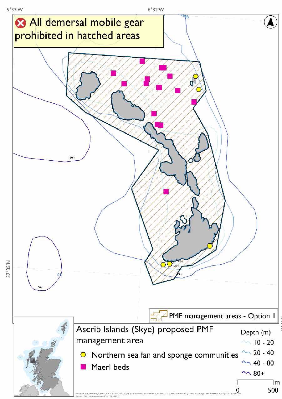
Option 2: This boundary covers a larger footprint that is extended in the southeast and west to include additional habitat of suitable depth.
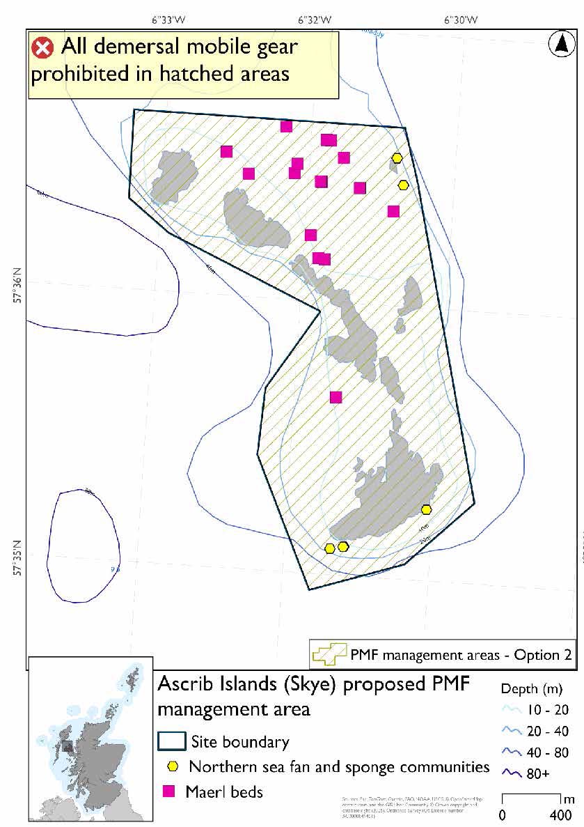
25.1.4 Other fisheries management measures currently applying to this area
There are already management measures in place. An effort has been made to identify existing measures which affect each individual site or area, however the list may not be exhaustive. These measures are outlined below, and the proposals for further management being consulted on now are in addition to these existing measures:
- Fishing for sandeel is prohibited within the Scottish zone, which is defined as the sea adjacent to Scotland up to the 200 nautical miles limit
25.2 Eddrachillis Bay (Assynt)
25.2.1 Description and background
Eddrachillis Bay (Assynt) proposed PMF management area covers the entirety of Eddrachillis Bay in the Northwest of Scotland. This area has been selected to protect:
- Maerl beds; and
- Seagrass beds
There are also northern sea fan and sponge communities records present, but they were not a focus for this area’s selection.
25.2.2 Fisheries management measures proposed
PMF management areas will be closed to demersal trawls and seines, beam trawls, mechanical dredges, and hydraulic dredges. This is because the features present in these areas are sensitive to these gear types.
25.2.3 Options under consideration
Two options have been developed for this for this PMF management area. Option 1 reflects a smaller footprint that reflects one, or a combination of evidence (fishing activity or PMF related), boundary setting principles and compliance considerations. Option 2 covers a larger footprint that offers improved protection.
The options were reduced on the eastern side, removing head of the loch, to better reflect known records at the time. There is a horse mussel bed record at the head of the loch but this is from 1988. No additional fishing data were provided within the proposed PMF management areas.
The additional maerl bed and northern sea fan and sponge communities records in Option 2 at the mouth of the loch are from survey data from 2023 and 2025 that was available after areas were finalised for consultation. There are maerl bed records from the 2025 survey outside both management options at the head of the loch that were not available when options were finalised for consultation.
Option 1: This boundary covers a smaller footprint which excludes some maerl beds and northern sea fan and sponge communities in the outer reaches of the loch
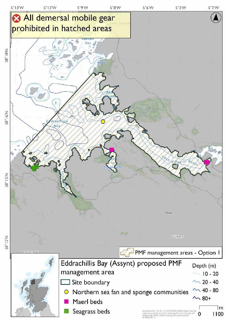
Option 2: This boundary covers a larger footprint which includes additional maerl beds, northern sea fan and sponge communities and further suitable habitat.
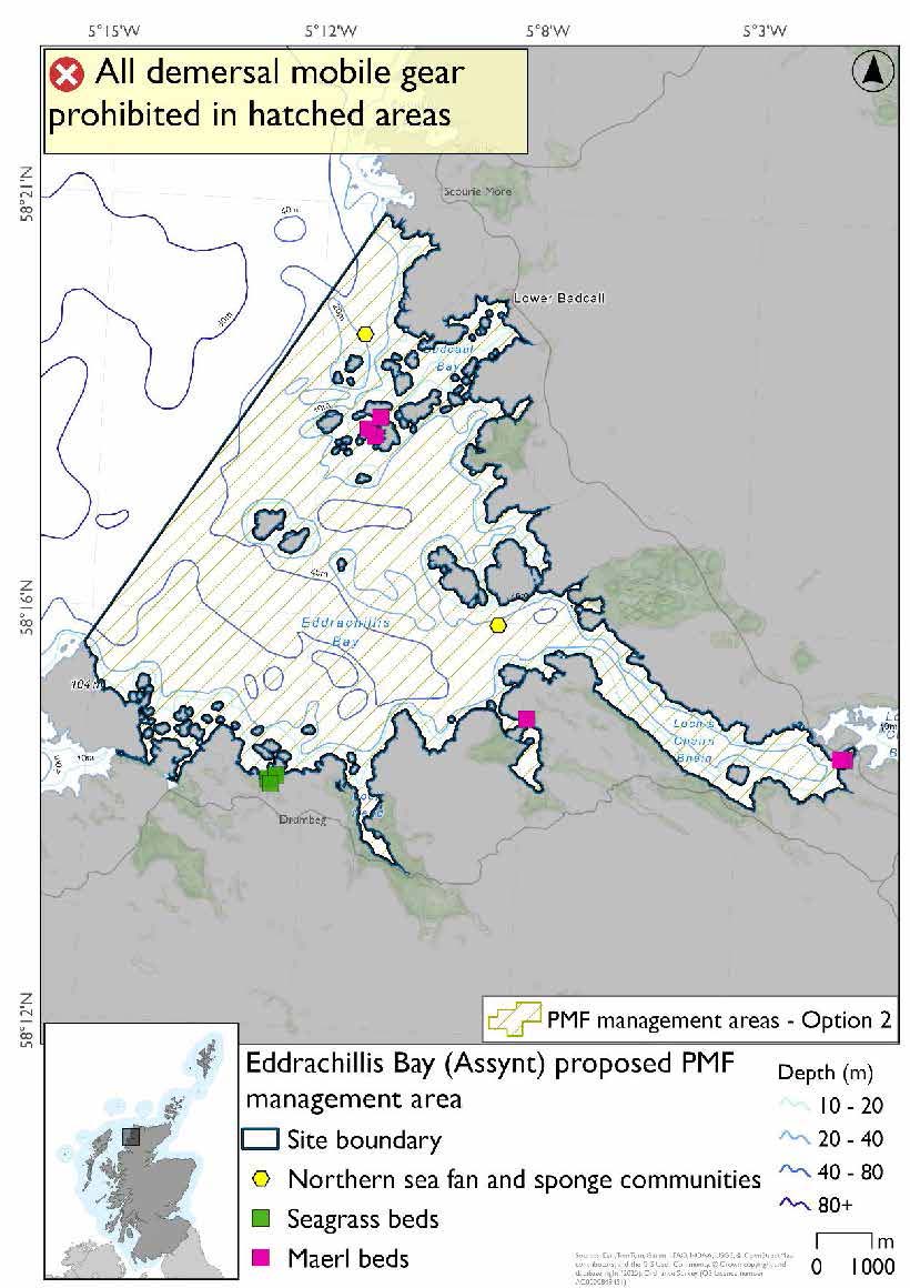
25.2.4 Other fisheries management measures currently applying to this area
There are already management measures in place. An effort has been made to identify existing measures which affect each individual site or area, however the list may not be exhaustive. These measures are outlined below, and the proposals for further management being consulted on now are in addition to these existing measures:
- Fishing for sea fish with mobile or active gear prohibited from 01 October to 31st March each year across the whole area
- Fishing with suction dredge prohibited across the whole area all year round
- Fishing for sandeel is prohibited within the Scottish zone, which is defined as the sea adjacent to Scotland up to the 200 nautical miles limit
25.3 Eigg, South-East
25.3.1 Description and background*
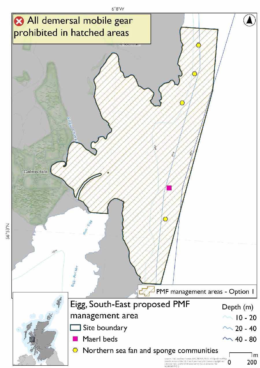
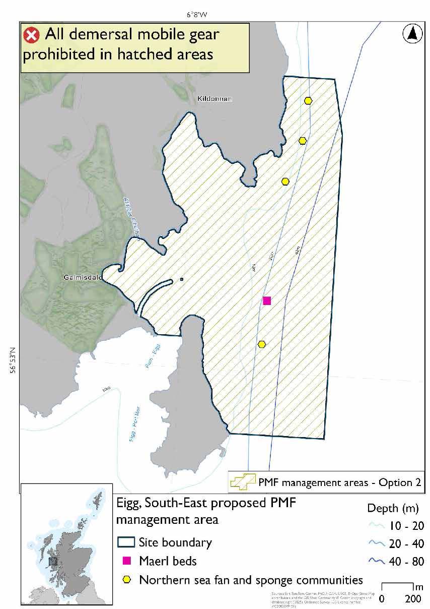
Eigg, South-East, proposed PMF management area covers a small area to the southeast of Eigg, including some of the coast of Eilean Chathastail. This area has been selected to protect:
- Maerl beds; and
- Northern sea fan and sponge communities
*This proposed PMF management area overlaps with the Sea of the Hebrides NCMPA and Inner Hebrides and the Minches SAC.
25.3.2 Fisheries management measures proposed
PMF management areas will be closed to demersal trawls and seines, beam trawls, mechanical dredges, and hydraulic dredges. This is because the features present in these areas are sensitive to these gear types.
This PMF management area overlaps with management measures being consulted on for Inner Hebrides and the Minches SAC and Sea of the Hebrides NCMPA for set nets (not including fyke nets) which are not shown in the maps below.
Please check one of the overlapping site map option(s) to see static gear measures. Both maps show the same thing for overlapping portion.
25.3.3 Options under consideration
Two options have been developed for this for this PMF management area. Option 1 reflects a smaller footprint that reflects one, or a combination of evidence (fishing activity or PMF related), boundary setting principles and compliance considerations. Option 2 covers a larger footprint that offers improved protection.
Option 1: This boundary covers a smaller footprint. Additional fishing data were provided and the area reduced whilst including suitable depths for maerl beds, the existing PMF records and buffers around these.
Option 2: This boundary covers a larger footprint that offers improved protection.
25.3.4 Other fisheries management measures currently applying to this area
There are already management measures in place. An effort has been made to identify existing measures which affect each individual site or area, however the list may not be exhaustive. These measures are outlined below, and the proposals for further management being consulted on now are in addition to these existing measures:
- Fishing for sandeel is prohibited within the Scottish zone, which is defined as the sea adjacent to Scotland up to the 200 nautical miles limit
25.4 Handa (Durness)
25.4.1 Description and background*
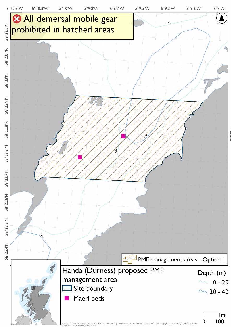
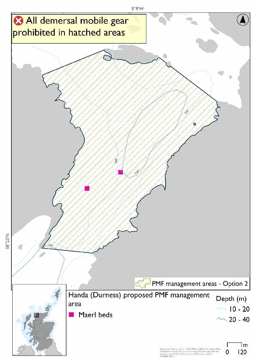
Handa (Durness) proposed PMF management area covers the waters between the island of Handa and the Scottish mainland. This area has been selected to protect:
- Maerl beds
*This proposed PMF management area overlaps with the Handa SPA.
25.4.2 Fisheries management measures proposed
PMF management areas will be closed to demersal trawls and seines, beam trawls, mechanical dredges, and hydraulic dredges. This is because the features present in these areas are sensitive to these gear types.
This PMF management area overlaps with management measures being consulted on for Handa SPA for set nets (including fyke nets) and longlines (until technical measures come into force) which are not shown in the maps below.
Please check overlapping site map option(s) to see static gear and longline measures.
25.4.3 Options under consideration
Two options have been developed for this for this PMF management area. Option 1 reflects a smaller footprint that reflects one, or a combination of evidence (fishing activity or PMF related), boundary setting principles and compliance considerations. Option 2 covers a larger footprint that offers improved protection.
No additional fishing data were provided within the proposed PMF management areas.
Option 1: This boundary covers a smaller footprint that more closely encompasses the PMF records.
Option 2: This boundary covers a larger footprint offering protection for additional potential habitat for maerl beds based on suitable depths.
25.4.4 Other fisheries management measures currently applying to this area
There are already management measures in place. An effort has been made to identify existing measures which affect each individual site or area, however the list may not be exhaustive. These measures are outlined below, and the proposals for further management being consulted on now are in addition to these existing measures:
- Fishing for sandeel is prohibited within the Scottish zone, which is defined as the sea adjacent to Scotland up to the 200 nautical miles limit
25.5 Inverie, Loch Nevis (Knoydart)
25.5.1 Description and background
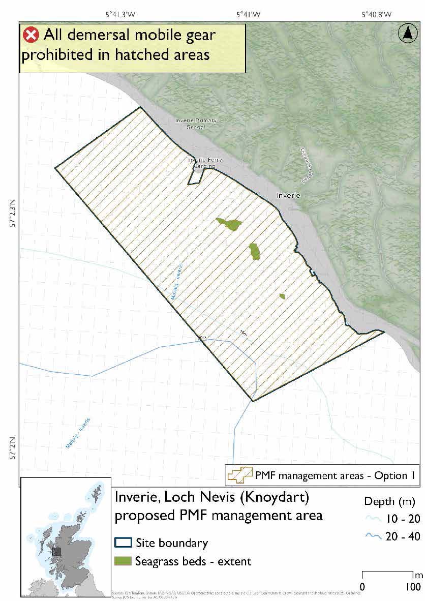
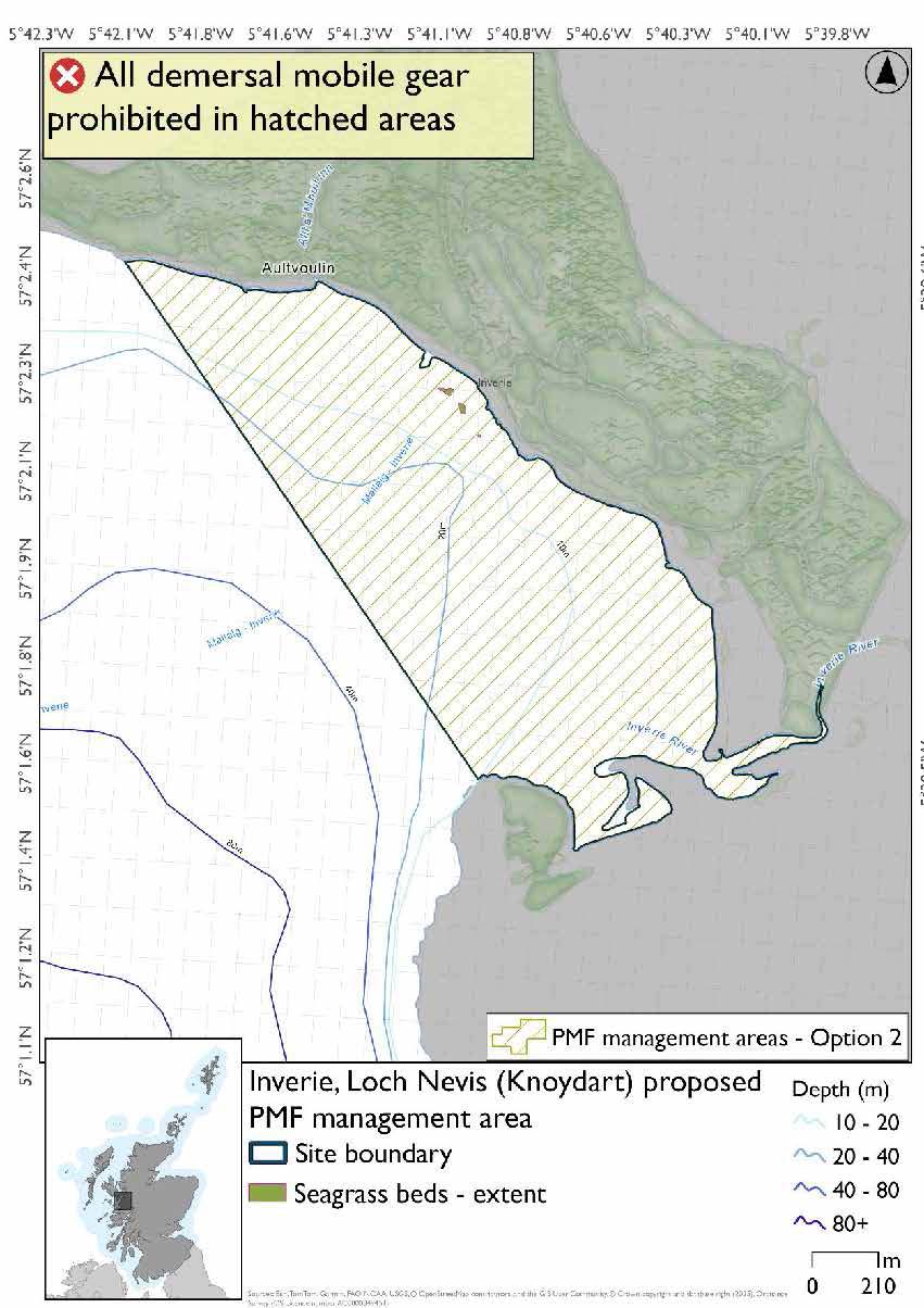
Inverie, Loch Nevis (Knoydart) proposed PMF management area covers the small bay by Inverie in Loch Nevis. This area has been selected to protect:
- Seagrass beds
25.5.2 Fisheries management measures proposed
PMF management areas will be closed to demersal trawls and seines, beam trawls, mechanical dredges, and hydraulic dredges. This is because the features present in these areas are sensitive to these gear types.
25.5.3 Options under consideration
Two options have been developed for this for this PMF management area. Option 1 reflects a smaller footprint that reflects one, or a combination of evidence (fishing activity or PMF related), boundary setting principles and compliance considerations. Option 2 covers a larger footprint that offers improved protection.
No additional fishing data were provided within the proposed PMF management areas.
Option 1: This boundary covers a smaller footprint to encompass the records of the PMF more closely.
Option 2: This boundary covers a larger footprint that offers improved protection.
25.5.4 Other fisheries management measures currently applying to this area
There are already management measures in place. An effort has been made to identify existing measures which affect each individual site or area, however the list may not be exhaustive. These measures are outlined below, and the proposals for further management being consulted on now are in addition to these existing measures:
- Fishing for sandeel is prohibited within the Scottish zone, which is defined as the sea adjacent to Scotland up to the 200 nautical miles limit
25.6 Little Minch
25.6.1 Description and background*
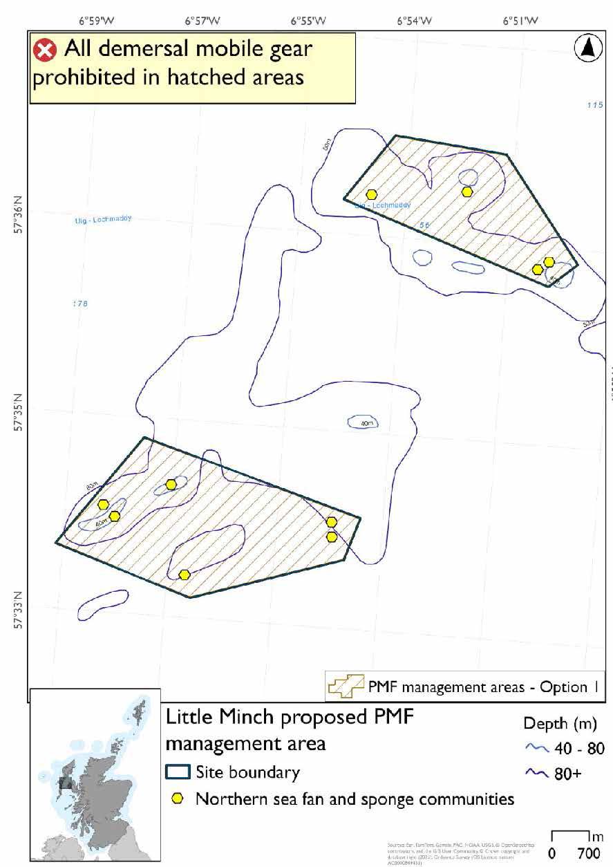
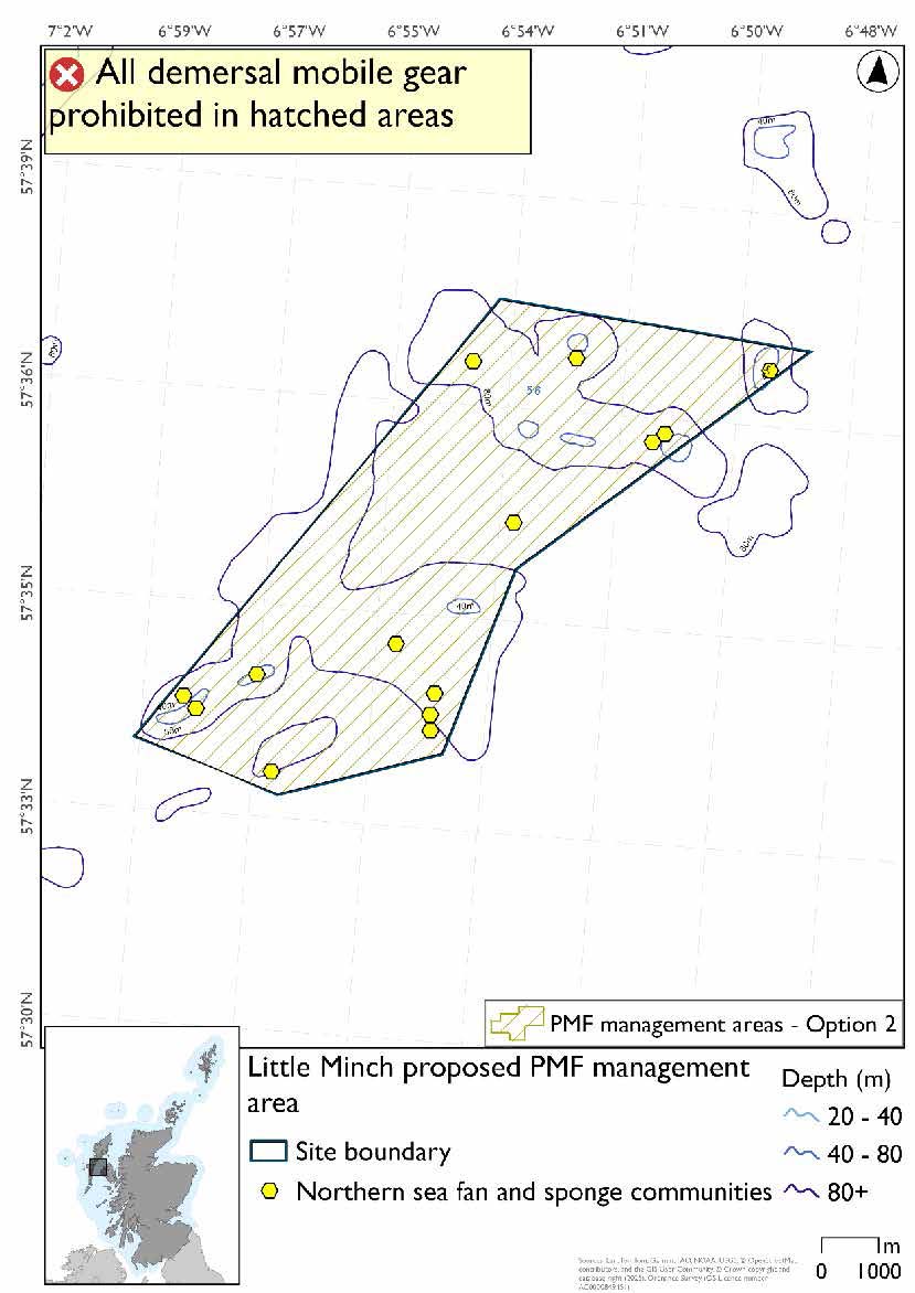
Little Minch proposed PMF management area covers an area of waters halfway between Skye and North Uist. This area has been selected to protect:
- Northern sea fan and sponge communities.
*This proposed PMF management area overlaps with the Sea of the Hebrides NCMPA and Inner Hebrides and the Minches SAC.
25.6.2 Fisheries management measures proposed
PMF management areas will be closed to demersal trawls and seines, beam trawls, mechanical dredges, and hydraulic dredges. This is because the features present in these areas are sensitive to these gear types.
This PMF management area overlaps with management measures being consulted on for Inner Hebrides and the Minches SAC and Sea of the Hebrides NCMPA for set nets (not including fyke nets) which are not shown in the maps below.
Please check both of the overlapping site map option(s) to see static gear measures. Each map will show the same overlapping measures but cover different areas.
25.6.3 Options under consideration
Two options have been developed for this for this PMF management area. Option 1 reflects a smaller footprint that reflects one, or a combination of evidence (fishing activity or PMF related), boundary setting principles and compliance considerations. Option 2 covers a larger footprint that offers improved protection.
Option 2 has northern sea fan and sponge communities that were not included in Option 1. NatureScot proposed that the focus of measures be around the clusters of existing 2011 records noting that it may be possible to split the area for Option 1 based on available survey and bathymetric data. The area between the northeast and southwest parts under Option 1 primarily supports northern sea fan species records only (low density presence).
Option 1: This boundary covers a smaller footprint over two discrete areas that encompass known PMF records. It also accommodates additional fishing data that were provided which overlaps the low density species only records of northern sea fan.
Option 2: This boundary covers a larger footprint which includes additional lower relief habitat that is suitable for the northern sea fan species.
25.6.4 Other fisheries management measures currently applying to this area
There are already management measures in place. An effort has been made to identify existing measures which affect each individual site or area, however the list may not be exhaustive. These measures are outlined below, and the proposals for further management being consulted on now are in addition to these existing measures:
- Fishing for sandeel is prohibited within the Scottish zone, which is defined as the sea adjacent to Scotland up to the 200 nautical miles limit
25.7 Loch Bay (Skye)
25.7.1 Description and background*
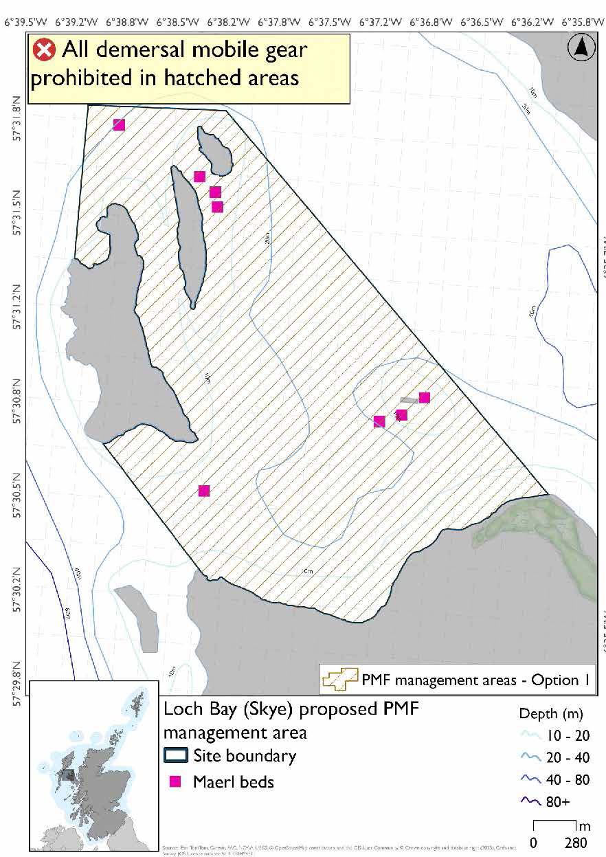
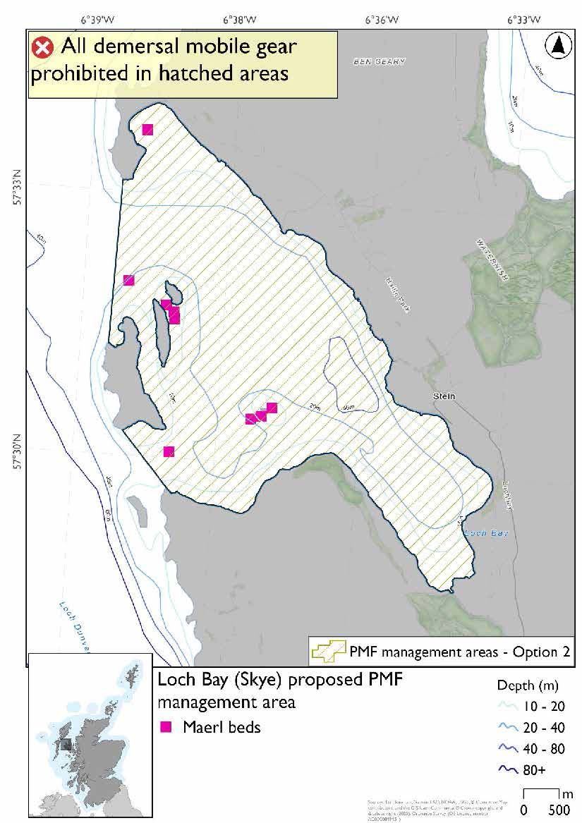
Loch Bay (Skye) proposed PMF management area covers the waters of Loch Bay on Skye as far as the eastern, northern, and southern coasts of Isay. This area has been selected to protect:
- Maerl beds
*This proposed PMF management area overlaps with the Ascrib, Isay and Dunvegan and Inner Hebrides and the Minches SACs.
25.7.2 Fisheries management measures proposed
PMF management areas will be closed to demersal trawls and seines, beam trawls, mechanical dredges, and hydraulic dredges. This is because the features present in these areas are sensitive to these gear types.
This PMF management area overlaps with management measures being consulted on for Ascrib, Isay and Dunvegan and Inner Hebrides and the Minches SACs for set nets (not including fyke nets) and Ascrib, Isay and Dunvegan SAC for pelagic seine (including ring-nets) which are not shown in the maps below.
Please check overlapping site map option(s) to see static and pelagic gear measures.
25.7.3 Options under consideration
Two options have been developed for this for this PMF management area. Option 1 reflects a smaller footprint that reflects one, or a combination of evidence (fishing activity or PMF related), boundary setting principles and compliance considerations. Option 2 covers a larger footprint that offers improved protection.
Option 2 (the 2018 area) has an additional maerl bed record not included in Option 1 as further survey work in 2024 and 2025 confirmed a new maerl bed in Ardmore Bay at the northern end of the 2018 area which wasn’t available when the areas were finalised for consultation.
Option 1: This boundary covers a smaller footprint encompassing a few clusters of maerl beds around the small islands in the southern, outer areas of the loch. Additional fishing data were provided and accommodated prior to knowing about the 2024/25 maerl bed data.
Option 2: This boundary covers a larger footprint and extends to include more maerl bed records in the north as well as including additional suitable habitat within the head of the loch.
25.7.4 Other fisheries management measures currently applying to this area
There are already management measures in place. An effort has been made to identify existing measures which affect each individual site or area, however the list may not be exhaustive. These measures are outlined below, and the proposals for further management being consulted on now are in addition to these existing measures:
- Fishing for sandeel is prohibited within the Scottish zone, which is defined as the sea adjacent to Scotland up to the 200 nautical miles limit
25.8 Loch Bracadale (Skye)
25.8.1 Description and background*
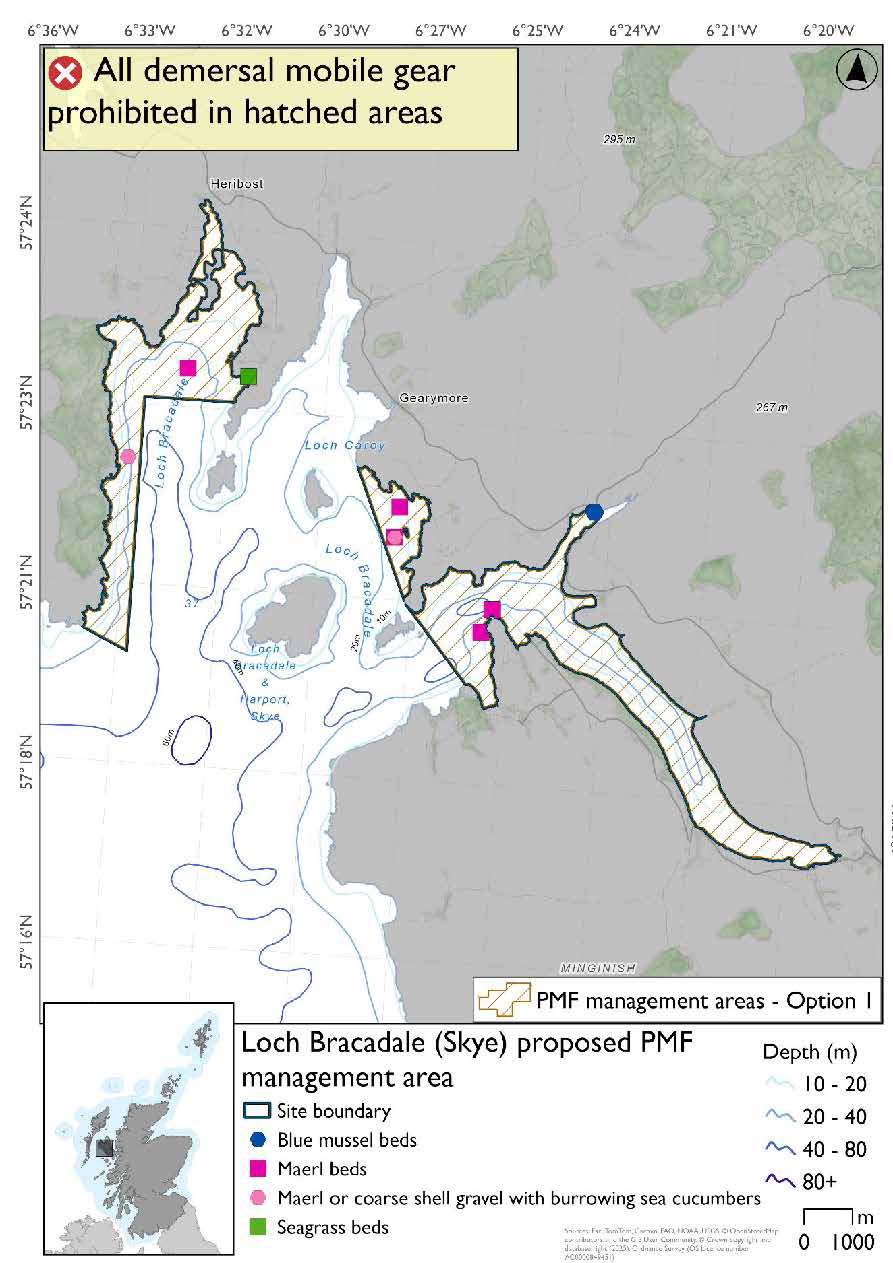
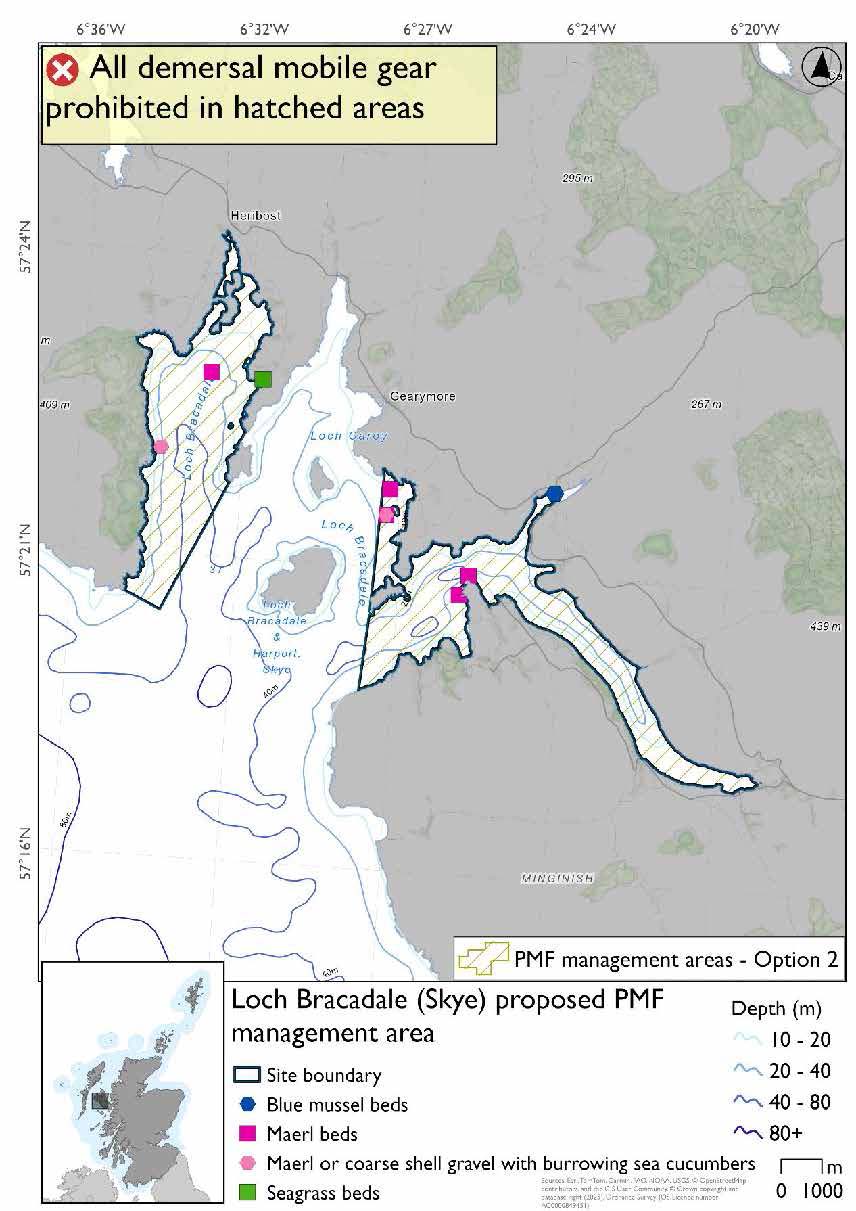
Loch Bracadale (Skye) proposed PMF management area covers two distinct areas containing Lochs Bracadale and Harport. The western area extends up to Harloch and the eastern portion up to Oronsay; the area does not contain the area between the two containing Wiay. This area has been selected to protect:
- Maerl beds; and
- Maerl or coarse shell gravel with burrowing sea cucumbers
There are also intertidal seagrass and blue mussel beds present, but they were not considered as part of this process due to there being no overlaps with bottom-contacting fisheries and intertidal beds.
*This proposed PMF management area overlaps with the Inner Hebrides and the Minches SAC.
25.8.2 Fisheries management measures proposed
PMF management areas will be closed to demersal trawls and seines, beam trawls, mechanical dredges, and hydraulic dredges. This is because the features present in these areas are sensitive to these gear types.
This PMF management area overlaps with management measures being consulted on for Inner Hebrides and the Minches SAC for set nets (not including fyke nets) which are not shown in the maps below.
Please check overlapping site map option(s) to see static gear measures.
25.8.3 Options under consideration
Two options have been developed for this for this PMF management area. Option 1 reflects a smaller footprint that reflects one, or a combination of evidence (fishing activity or PMF related), boundary setting principles and compliance considerations. Option 2 covers a larger footprint that offers improved protection.
Option 1: This boundary covers a smaller footprint, over two discrete areas of the loch, to reflect the known records. Additional fishing data were received and accommodated whilst protecting known records at the time of finalising the options for consultation and including buffers.
Option 2: This boundary covers a larger footprint that includes additional suitable habitat for the PMFs.
25.8.4 Other fisheries management measures currently applying to this area
There are already management measures in place. An effort has been made to identify existing measures which affect each individual site or area, however the list may not be exhaustive. These measures are outlined below, and the proposals for further management being consulted on now are in addition to these existing measures:
- Fishing for sandeel is prohibited within the Scottish zone, which is defined as the sea adjacent to Scotland up to the 200 nautical miles limit
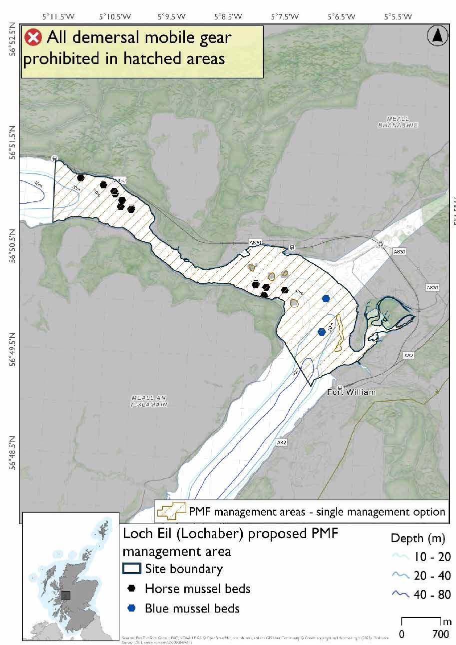
25.9 Loch Eil (Lochaber)
25.9.1 Description and background
Loch Eil (Lochaber) proposed PMF management area covers Loch Eil from Fort William to Fassfern. This area has been selected to protect:
- Horse mussel beds
There are also intertidal blue mussel records present, but they were not considered part of this process due to there being no overlaps with bottom-contacting fisheries and intertidal mussel beds.
25.9.2 Fisheries management measures proposed
PMF management areas will be closed to demersal trawls and seines, beam trawls, mechanical dredges, and hydraulic dredges. This is because the features present in these areas are sensitive to these gear types.
25.9.3 Options under consideration
A single management option has been developed for this PMF management area. Only one option was identified due to one of, or combination of, evidence (fishing activity or PMF related), boundary setting principles and compliance considerations.
No additional fishing data were provided within the proposed PMF management area.
25.9.4 Other fisheries management measures currently applying to this area
There are already management measures in place. An effort has been made to identify existing measures which affect each individual site or area, however the list may not be exhaustive. These measures are outlined below, and the proposals for further management being consulted on now are in addition to these existing measures:
- Fishing for sandeel is prohibited within the Scottish zone, which is defined as the sea adjacent to Scotland up to the 200 nautical miles limit
25.10 Loch Hourn (Knoydart)
25.10.1 Description and background
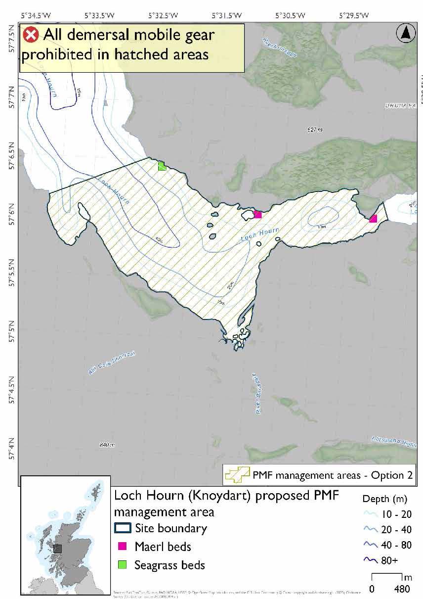
Loch Hourn (Knoydart) proposed PMF management area covers an area of Loch Hourn extending 3 kilometers west of Barrisdale, and 2.3 kilometers east of Barrisdale. This area has been selected to protect:
- Maerl beds; and
- Seagrass beds
25.10.2 Fisheries management measures proposed
PMF management areas will be closed to demersal trawls and seines, beam trawls, mechanical dredges, and hydraulic dredges. This is because the features present in these areas are sensitive to these gear types.
25.10.3 Options under consideration
Two options have been developed for this for this PMF management area. Option 1 reflects a smaller footprint that reflects one, or a combination of evidence (fishing activity or PMF related), boundary setting principles and compliance considerations. Option 2 covers a larger footprint that offers improved protection.
Option 1: This boundary covers a smaller footprint that encompasses known records of the PMFs.
Additional fishing data were received and accommodated, whilst protecting known records at the time of finalising the options for consultation and including buffers.
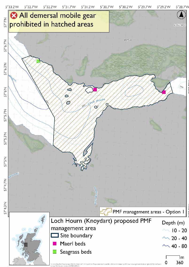
Option 2: This boundary covers a larger footprint, including additional suitable habitat for the PMFs.
25.10.4 Other fisheries management measures currently applying to this area
There are already management measures in place. An effort has been made to identify existing measures which affect each individual site or area, however the list may not be exhaustive. These measures are outlined below, and the proposals for further management being consulted on now are in addition to these existing measures:
- Dredge, beam trawl, demersal trawl or demersal seine net is prohibited in part of the area all year
- Suction dredges prohibited all year across part of the area
- 01 October until 31st March Fishing for sea fish with a dredge, beam trawl, demersal trawl or demersal seine net is prohibited across part of the area
- 01 April until 30 September Fishing for sea fish with a dredge, beam trawl, demersal trawl or demersal seine net is prohibited across part of the area. Does not apply to either a fishing boat with a single beam trawl or demersal seine; or from a fishing boat with a registered length less than 12 metres with a single demersal trawl [or] a mechanical dredge
- Fishing for sandeel is prohibited within the Scottish zone, which is defined as the sea adjacent to Scotland up to the 200 nautical miles limit
25.11 Loch Leven, Ballachullish (Lochaber)
25.11.1 Description and background
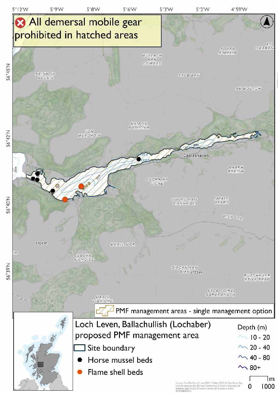
Loch Leven, Ballachullish (Lochaber) proposed PMF management area covers the length of Loch Leven, with its outermost extent at Ballachullish. This area has been selected to protect:
- Flame shell beds; and
- Horse mussel beds
25.11.2 Fisheries management measures proposed
PMF management areas will be closed to demersal trawls and seines, beam trawls, mechanical dredges, and hydraulic dredges. This is because the features present in these areas are sensitive to these gear types.
25.11.3 Options under consideration
A single management option has been developed for this PMF management area. Only one option was identified due to one of, or combination of, evidence (fishing activity or PMF related), boundary setting principles and compliance considerations.
The boundary of the 2018 area was brought to the narrows to encompass the PMF records more closely. No additional fishing data were provided within the proposed PMF management area.
25.11.4 Other fisheries management measures currently applying to this area
There are already management measures in place. An effort has been made to identify existing measures which affect each individual site or area, however the list may not be exhaustive. These measures are outlined below, and the proposals for further management being consulted on now are in addition to these existing measures:
- Fishing for sandeel is prohibited within the Scottish zone, which is defined as the sea adjacent to Scotland up to the 200 nautical miles limit
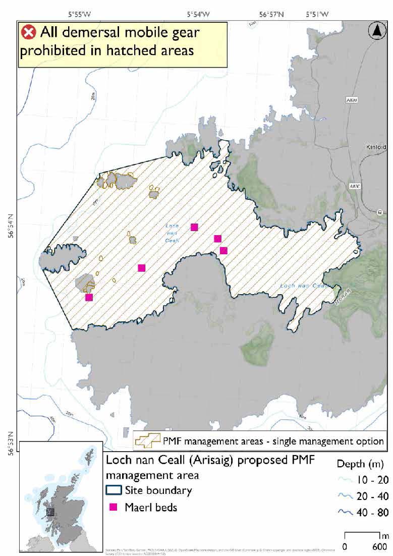
25.12 Loch nan Ceall (Arisaig)
25.12.1 Description and background*
Loch nan Ceall (Arisaig) proposed PMF management area covers Loch nan Ceall and the southern coast of the Arisaig Skerries. This area has been selected to protect:
- Maerl beds
*This proposed PMF management area overlaps with the Inner Hebrides and the Minches SAC.
25.12.2 Fisheries management measures proposed
PMF management areas will be closed to demersal trawls and seines, beam trawls, mechanical dredges, and hydraulic dredges. This is because the features present in these areas are sensitive to these gear types.
This PMF management area overlaps with management measures being consulted on for Inner Hebrides and the Minches SAC for set nets (not including fyke nets) which are not shown in the map below.
Please check overlapping site map option(s) to see static gear measures.
25.12.3 Options under consideration
A single management option has been developed for this PMF management area. Only one option was identified due to one of, or combination of, evidence (fishing activity or PMF related), boundary setting principles and compliance considerations.
No additional fishing data were provided within the proposed PMF management area.
25.12.4 Other fisheries management measures currently applying to this area
There are already management measures in place. An effort has been made to identify existing measures which affect each individual site or area, however the list may not be exhaustive. These measures are outlined below, and the proposals for further management being consulted on now are in addition to these existing measures:
- Fishing for sandeel is prohibited within the Scottish zone, which is defined as the sea adjacent to Scotland up to the 200 nautical miles limit
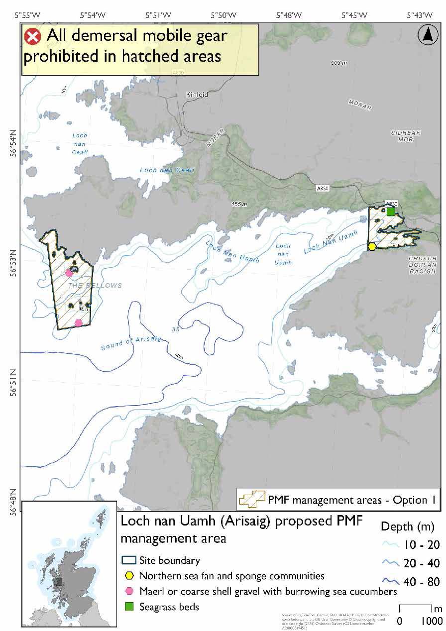
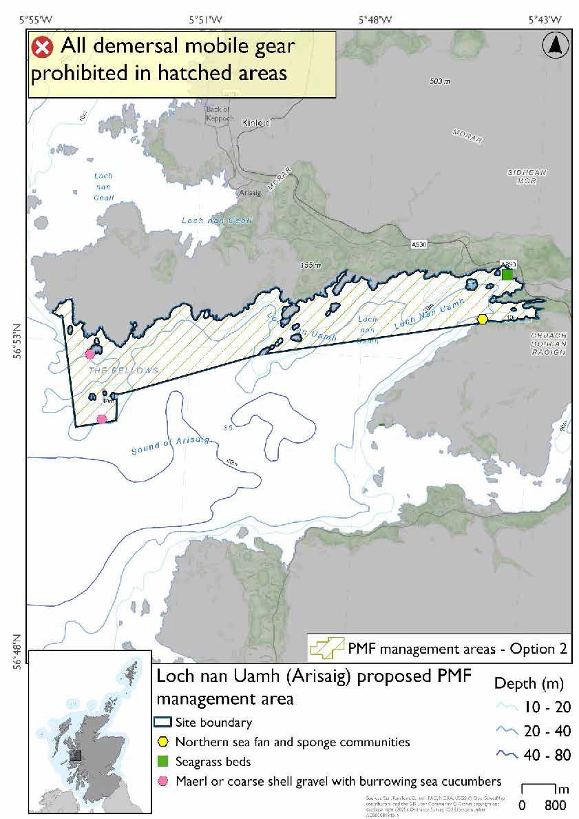
25.13 Loch nan Uamh (Arisaig)
25.13.1 Description and background*
Loch nan Uamh (Arisaig) proposed PMF management area covers Loch nan Uamh and the southern coast of the Rhu Peninsula. This area has been selected to protect:
- Maerl or coarse shell gravel with burrowing sea cucumbers;
- Northern sea fan and sponge communities; and
- Seagrass beds
There are also intertidal blue mussel records present, but they were not considered part of this process due to there being no overlaps with bottom-contacting fisheries and intertidal mussel beds.
*This proposed PMF management area overlaps with the Inner Hebrides and the Minches SAC.
25.13.2 Fisheries management measures proposed
PMF management areas will be closed to demersal trawls and seines, beam trawls, mechanical dredges, and hydraulic dredges. This is because the features present in these areas are sensitive to these gear types.
This PMF management area overlaps with management measures being consulted on for Inner Hebrides and the Minches SAC for set nets (not including fyke nets) which are not shown in the maps below.
Please check overlapping site map option(s) to see static gear measures.
25.13.3 Options under consideration
Two options have been developed for this for this PMF management area. Option 1 reflects a smaller footprint that reflects one, or a combination of evidence (fishing activity or PMF related), boundary setting principles and compliance considerations. Option 2 covers a larger footprint that offers improved protection.
Option 1: This boundary covers a smaller footprint with two discrete locations at head and mouth of loch that encompass known PMF records. Additional fishing data were received and accommodated whilst protecting known records at the time of finalising the options for consultation and including buffers.
Option 2: This boundary covers a larger footprint along the northern edge of the loch including additional habitat suitable for PMFs.
25.13.4 Other fisheries management measures currently applying to this area
There are already management measures in place. An effort has been made to identify existing measures which affect each individual site or area, however the list may not be exhaustive. These measures are outlined below, and the proposals for further management being consulted on now are in addition to these existing measures:
- Fishing for sandeel is prohibited within the Scottish zone, which is defined as the sea adjacent to Scotland up to the 200 nautical miles limit
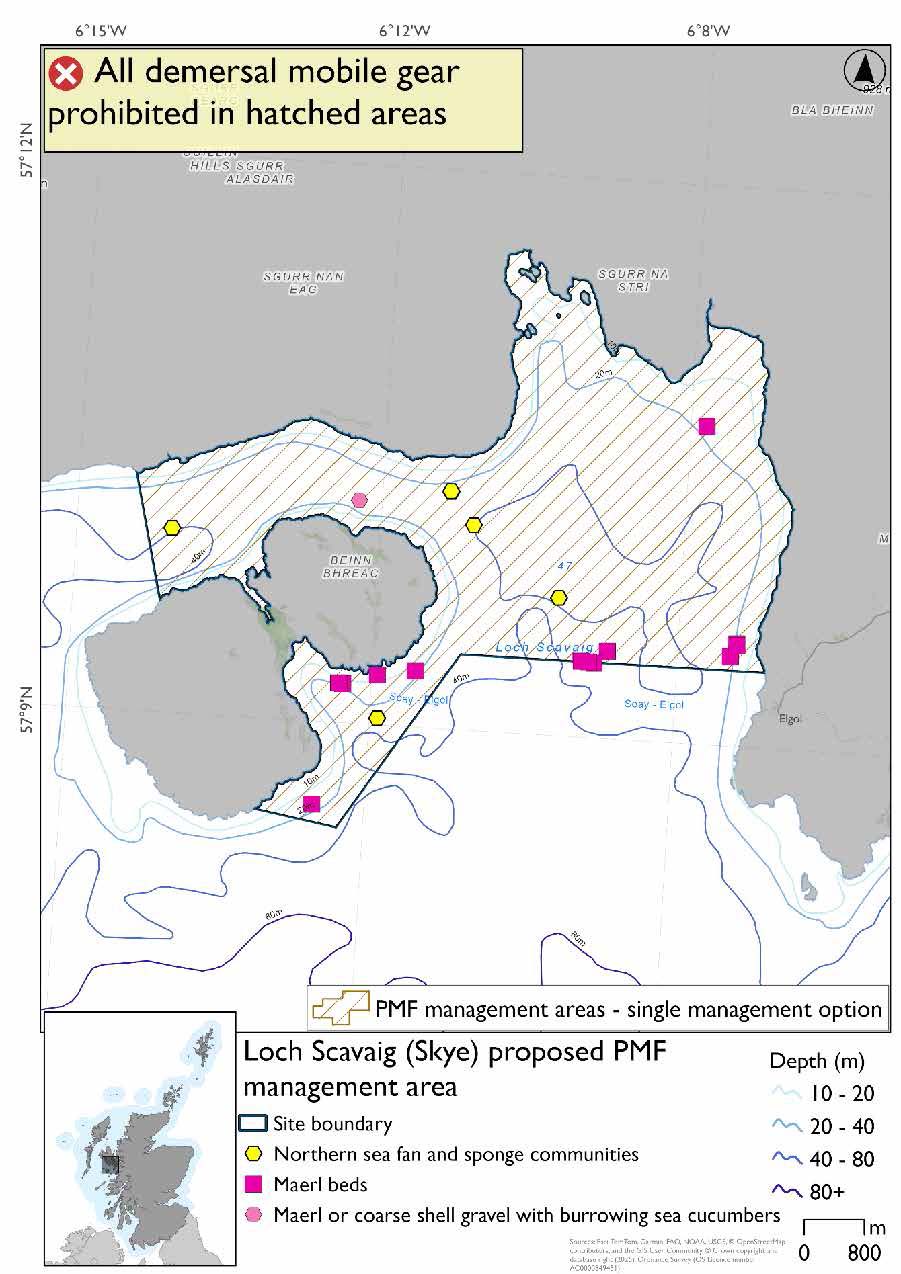
25.14 Loch Scavaig (Skye)
25.14.1 Description and background*
Loch Scavaig (Skye) proposed PMF management area covers Loch Scavaig on Skye, down to Elgol and across to Soay, including some of the Soay coast. This area has been selected to protect:
- Maerl beds;
- Maerl or coarse shell gravel with burrowing sea cucumbers; and
- Northern sea fan and sponge communities
*This proposed PMF management area overlaps with the Inner Hebrides and the Minches SAC.
25.14.2 Fisheries management measures proposed
PMF management areas will be closed to demersal trawls and seines, beam trawls, mechanical dredges, and hydraulic dredges. This is because the features present in these areas are sensitive to these gear types.
This PMF management area overlaps with management measures being consulted on for Inner Hebrides and the Minches SAC for set nets (not including fyke nets) which are not shown in the map below.
Please check overlapping site map option(s) to see static gear measures.
25.14.3 Options under consideration
A single management option has been developed for this PMF management area. Only one option was identified due to one of, or combination of, evidence (fishing activity or PMF related), boundary setting principles and compliance considerations.
Additional fishing activity data were provided and adjustments made to the 2018 area’s boundary to reduce the area as much as possible whilst maintaining adequate buffers around the PMF records.
Maerl bed records at the area boundary have not had buffers applied as these were from a 2024 survey which was only available after the area was finalised for consultation.
25.14.5 Other fisheries management measures currently applying to this area
There are already management measures in place. An effort has been made to identify existing measures which affect each individual site or area, however the list may not be exhaustive. These measures are outlined below, and the proposals for further management being consulted on now are in addition to these existing measures:
- Fishing for sandeel is prohibited within the Scottish zone, which is defined as the sea adjacent to Scotland up to the 200 nautical miles limit
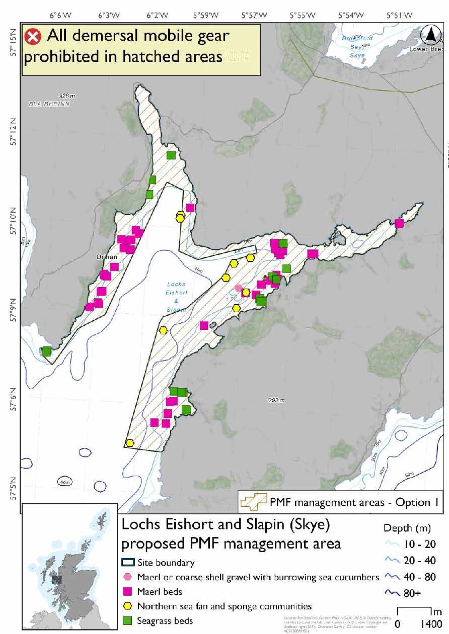
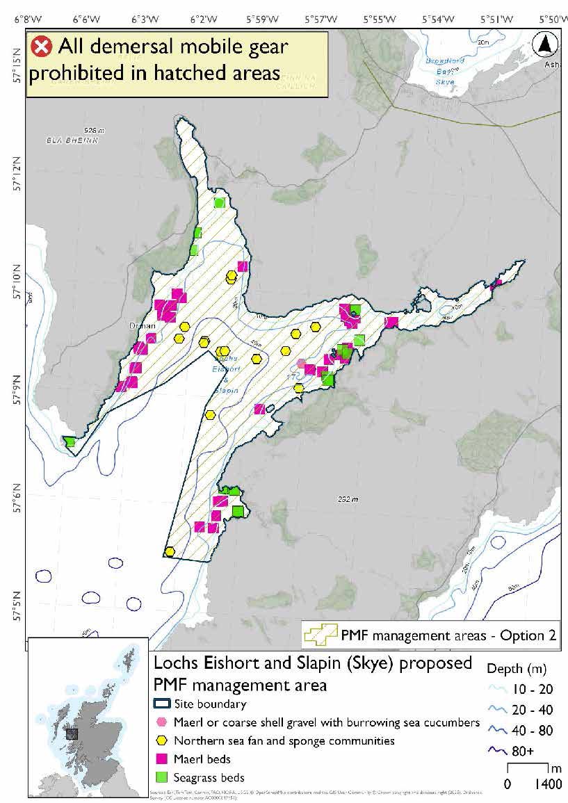
25.15 Lochs Eishort and Slapin (Skye)
25.15.1 Description and background*
Lochs Eishort and Slapin (Skye) proposed PMF management area covers a continuous area including both Lochs Eishort and Slapin on the south coast of Skye. This area has been selected to protect:
- Maerl beds;
- Maerl or coarse shell gravel with burrowing sea cucumbers;
- Northern sea fan and sponge communities; and
- Seagrass beds
*This proposed PMF management area overlaps with the Inner Hebrides and the Minches SAC.
25.15.2 Fisheries management measures proposed
PMF management areas will be closed to demersal trawls and seines, beam trawls, mechanical dredges, and hydraulic dredges. This is because the features present in these areas are sensitive to these gear types.
This PMF management area overlaps with management measures being consulted on for Inner Hebrides and the Minches SAC for set nets (not including fyke nets) which are not shown in the maps below.
Please check overlapping site map option(s) to see static gear measures.
25.15.3 Options under consideration
Two options have been developed for this for this PMF management area. Option 1 reflects a smaller footprint that reflects one, or a combination of evidence (fishing activity or PMF related), boundary setting principles and compliance considerations. Option 2 covers a larger footprint that offers improved protection.
Option 2 has northern sea fan and sponge communities that were not included in Option 1. The excluded area overlaps with additional fishing data that were provided. The excluded northern sea fan and sponge communities records are considered to be of lower diversity.
Option 1: This boundary covers a smaller footprint around the margins of the loch, excluding mostly deeper mud habitats not suitable for the PMFs being considered in this process, and accommodating, where possible, additional fishing data that were provided.
Option 2: This boundary covers a larger footprint that includes additional records of northern sea fan and sponge communities (lower diversity examples) on silted rock outcrops in mud.
25.15.4 Other fisheries management measures currently applying to this area
There are already management measures in place. An effort has been made to identify existing measures which affect each individual site or area, however the list may not be exhaustive. These measures are outlined below, and the proposals for further management being consulted on now are in addition to these existing measures:
- Fishing for sandeel is prohibited within the Scottish zone, which is defined as the sea adjacent to Scotland up to the 200 nautical miles limit
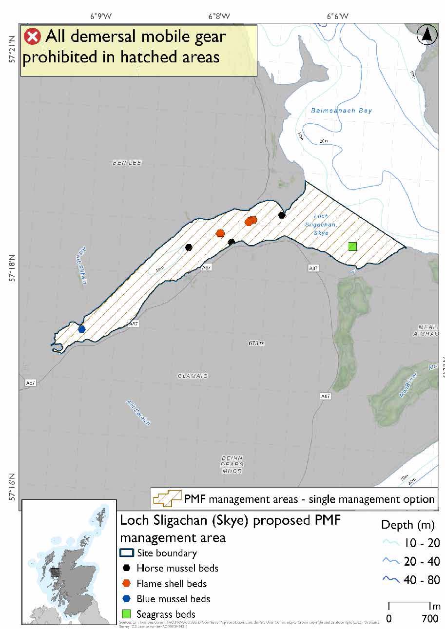
25.16 Loch Sligachan (Skye)
25.16.1 Description and background*
Loch Sligachan (Skye) proposed PMF management area covers the entirety of Loch Sligachan on Skye. This area has been selected to protect:
- Flame shell beds; and
- Horse mussel beds
There are also intertidal seagrass and blue mussel beds present, but they were not considered as part of this process due to there being no overlaps with bottom-contacting fisheries and intertidal beds.
*This proposed PMF management area overlaps with the Inner Hebrides and the Minches SAC.
25.16.2 Fisheries management measures proposed
PMF management areas will be closed to demersal trawls and seines, beam trawls, mechanical dredges, and hydraulic dredges. This is because the features present in these areas are sensitive to these gear types.
This PMF management area overlaps with management measures being consulted on for Inner Hebrides and the Minches SAC for set nets (not including fyke nets) which are not shown in the map below.
Please check overlapping site map option(s) to see static gear measures.
25.16.3 Options under consideration
A single management option has been developed for this PMF management area. Only one option was identified due to one of, or combination of, evidence (fishing activity or PMF related), boundary setting principles and compliance considerations.
No additional fishing data were provided within the proposed PMF management area.
25.16.4 Other fisheries management measures currently applying to this area
There are already management measures in place. An effort has been made to identify existing measures which affect each individual site or area, however the list may not be exhaustive. These measures are outlined below, and the proposals for further management being consulted on now are in addition to these existing measures:
- Fishing for sandeel is prohibited within the Scottish zone, which is defined as the sea adjacent to Scotland up to the 200 nautical miles limit
25.17 Loch Ainort and Caolas Scalpay (Skye)
25.17.1 Description and background*
Loch Ainort and Caolas Scalpay (Skye) proposed PMF management area covers Loch Ainort and the adjacent waters between Skye and Scalpay, round the entire southern coastline of Scalpay. This area has been selected to protect:
- Flame shell beds;
- Maerl beds;
- Horse mussel beds; and
- Seagrass beds
*This proposed PMF management area overlaps with the Inner Hebrides and the Minches SAC.
25.17.2 Fisheries management measures proposed
PMF management areas will be closed to demersal trawls and seines, beam trawls, mechanical dredges, and hydraulic dredges. This is because the features present in these areas are sensitive to these gear types.
This PMF management area overlaps with management measures being consulted on for Inner Hebrides and the Minches SAC for set nets (not including fyke nets) which are not shown in the maps below.
Please check overlapping site map option(s) to see static gear measures.
25.17.3 Options under consideration
Two options have been developed for this for this PMF management area. Option 1 reflects a smaller footprint that reflects one, or a combination of evidence (fishing activity or PMF related), boundary setting principles and compliance considerations. Option 2 covers a larger footprint that offers improved protection.
No additional fishing data were provided within the proposed PMF management areas.
Option 1: This boundary covers a smaller footprint that encompasses the PMFs with a simple boundary lines across to Scalpay.
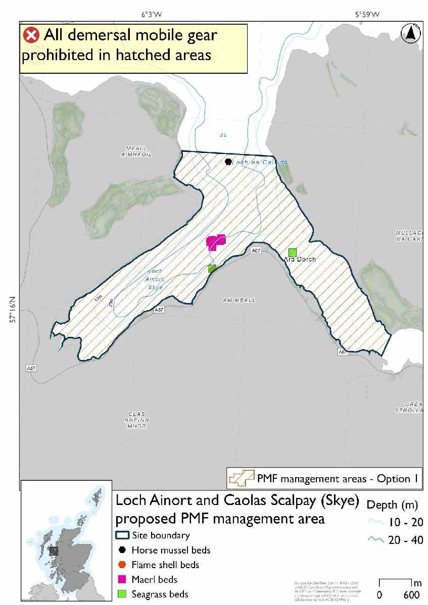
*Flame shell bed records are present amongst the large cluster of maerl bed records.
Option 2: This boundary covers a larger footprint and includes additional habitat that may be suitable for the PMFs.
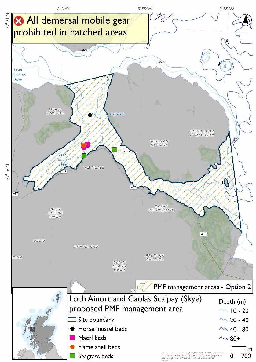
*Flame shell bed records are present amongst the large cluster of maerl bed records.
25.17.4 Other fisheries management measures currently applying to this area
There are already management measures in place. An effort has been made to identify existing measures which affect each individual site or area, however the list may not be exhaustive. These measures are outlined below, and the proposals for further management being consulted on now are in addition to these existing measures:
- Dredge, beam trawl, demersal trawl or demersal seine net is prohibited in part of the area all year
- Suction dredges prohibited all year across part of the area
- 01 October until 31st March Fishing for sea fish with a dredge, beam trawl, demersal trawl or demersal seine net is prohibited across part of the area
- 01 April until 30 September Fishing for sea fish with a dredge, beam trawl, demersal trawl or demersal seine net is prohibited across part of the area. Does not apply to either a fishing boat with a single beam trawl or demersal seine; or from a fishing boat with a registered length less than 12 metres with a single demersal trawl [or] a mechanical dredge
- Fishing for sandeel is prohibited within the Scottish zone, which is defined as the sea adjacent to Scotland up to the 200 nautical miles limit
25.18 Muck and Godag
25.18.1 Description and background*
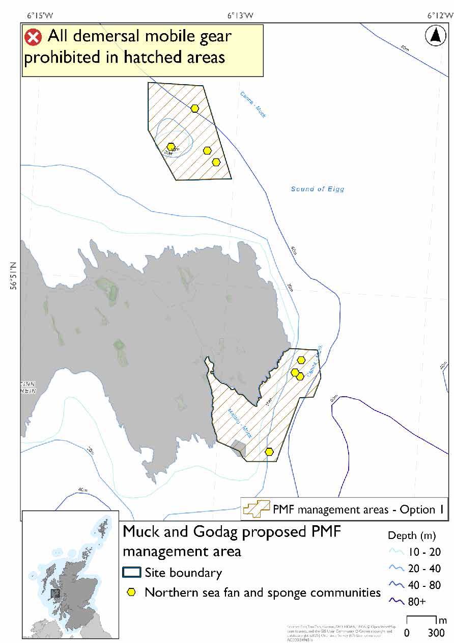
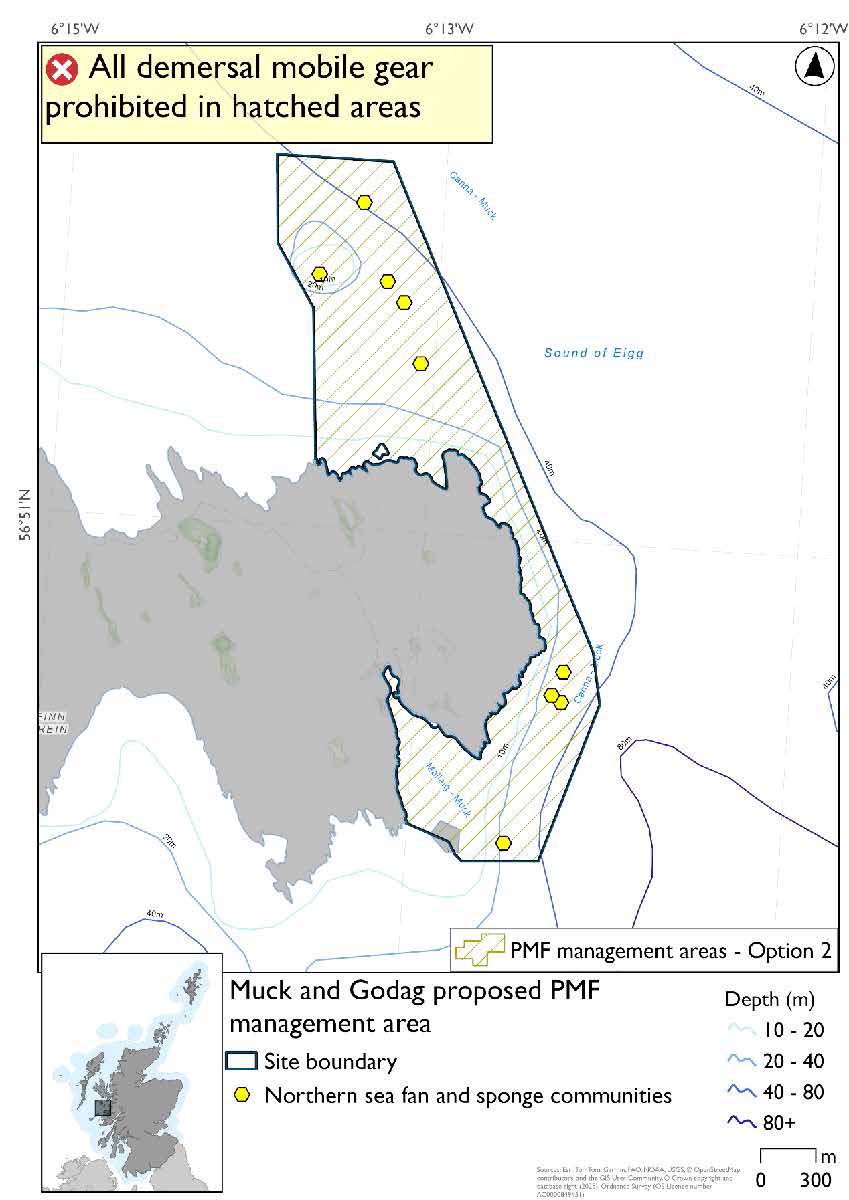
Muck and Godag proposed PMF management area covers the eastern end of Muck, including the waters around Port Mor, and the area stretching up to Godag, north of Muck. This area has been selected to protect:
- Northern sea fan and sponge communities.
*This proposed PMF management area overlaps with the Sea of the Hebrides NCMPA and Inner Hebrides and the Minches SAC.
25.18.2 Fisheries management measures proposed
PMF management areas will be closed to demersal trawls and seines, beam trawls, mechanical dredges, and hydraulic dredges. This is because the features present in these areas are sensitive to these gear types.
This PMF management area overlaps with management measures being consulted on for Inner Hebrides and the Minches SAC and Sea of the Hebrides NCMPA for set nets (not including fyke nets) which are not shown in the maps below.
Please check one of the overlapping site map option(s) to see static gear measures. Both maps show the same thing for overlapping portion.
25.18.3 Options under consideration
Two options have been developed for this for this PMF management area. Option 1 reflects a smaller footprint that reflects one, or a combination of evidence (fishing activity or PMF related), boundary setting principles and compliance considerations. Option 2 covers a larger footprint that offers improved protection.
No additional fishing data were provided within the proposed PMF management area.
Option 2 includes an additional northern sea fan and sponge communities record in the northern section, not included in Option 1. This was from a 2025 survey where data were only available after the area was finalised for consultation.
Option 1: This boundary covers a smaller footprint within two discrete areas around known PMF records.
Option 2: This boundary covers a larger single area that includes additional potential suitable habitat for the PMF.
25.18.4 Other fisheries management measures currently applying to this area
There are already management measures in place. An effort has been made to identify existing measures which affect each individual site or area, however the list may not be exhaustive. These measures are outlined below, and the proposals for further management being consulted on now are in addition to these existing measures:
- Fishing for sandeel is prohibited within the Scottish zone, which is defined as the sea adjacent to Scotland up to the 200 nautical miles limit
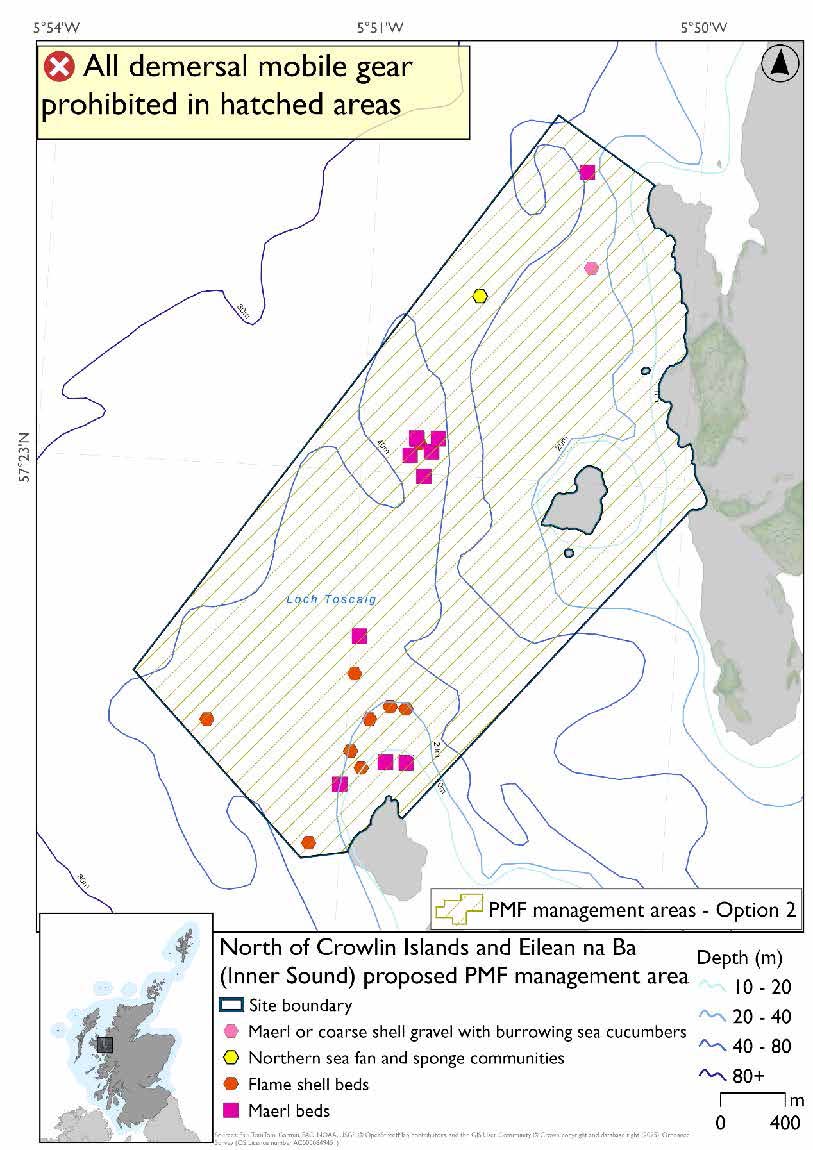
25.19 North of Crowlin Islands and Eilean na Ba (Inner Sound)
25.19.1 Description and background*
North of Crowlin Islands and Eilean na Ba (Inner Sound) proposed PMF management area extends north from the northern coast Eilean Beag in the Crowlin Islands to the coast near Applecross. This area has been selected to protect:
- Flame shell beds; and
- Maerl beds
There are also maerl or coarse shell gravel with burrowing sea cucumber and northern sea fan and sponge communities records present, but they were not the focus for this area’s selection.
*This proposed PMF management area overlaps with the Inner Hebrides and the Minches SAC.
25.19.2 Fisheries management measures proposed
PMF management areas will be closed to demersal trawls and seines, beam trawls, mechanical dredges, and hydraulic dredges. This is because the features present in these areas are sensitive to these gear types.
This PMF management area overlaps with management measures being consulted on for Inner Hebrides and the Minches SAC for set nets (not including fyke nets) which are not shown in the maps below.
Please check overlapping site map option(s) to see static gear measures.
25.19.3 Options under consideration
Two options have been developed for this for this PMF management area. Option 1 reflects a smaller footprint that reflects one, or a combination of evidence (fishing activity or PMF related), boundary setting principles and compliance considerations. Option 2 covers a larger footprint that offers improved protection.
No additional fishing data were provided within the proposed PMF management area.
Option 2 includes an additional flame shell bed record in the southwest section, not included in Option 1, as this was from a 2025 survey and data were not available until after the area was finalised for consultation.
Option 1: This boundary covers a smaller footprint that includes the clusters of PMF records.
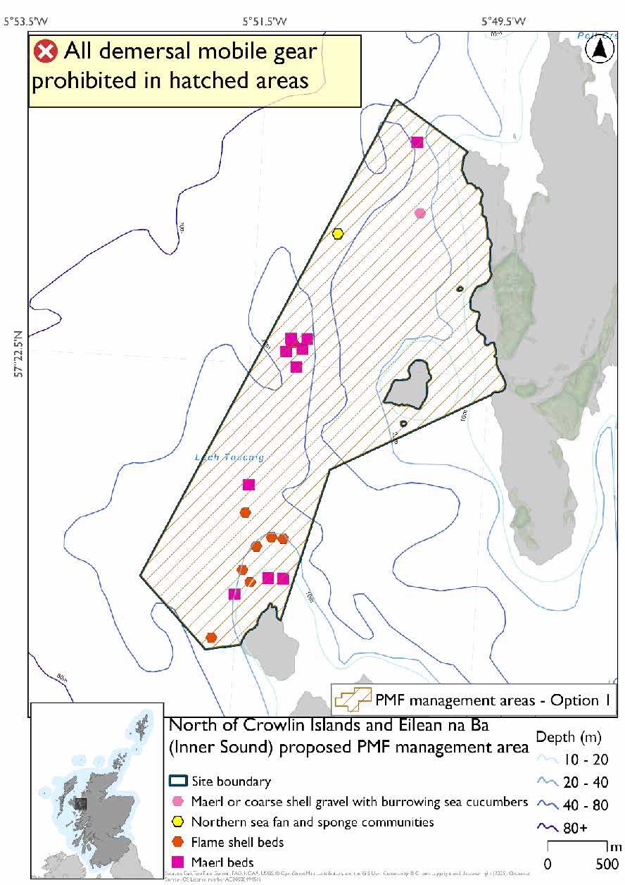
Option 2: This boundary covers a larger footprint, and includes an additional record of flame shell beds, and habitat that may be suitable for the PMFs.
25.19.4 Other fisheries management measures currently applying to this area
There are already management measures in place. An effort has been made to identify existing measures which affect each individual site or area, however the list may not be exhaustive. These measures are outlined below, and the proposals for further management being consulted on now are in addition to these existing measures:
- Dredge, beam trawl, demersal trawl or demersal seine net is prohibited in part of the area all year
- Suction dredges prohibited all year across part of the area
- 01 October until 31st March Fishing for sea fish with a dredge, beam trawl, demersal trawl or demersal seine net is prohibited across part of the area
- 01 April until 30 September Fishing for sea fish with a dredge, beam trawl, demersal trawl or demersal seine net is prohibited across part of the area. Does not apply to either a fishing boat with a single beam trawl or demersal seine; or from a fishing boat with a registered length less than 12 metres with a single demersal trawl [or] a mechanical dredge
- Fishing for sandeel is prohibited within the Scottish zone, which is defined as the sea adjacent to Scotland up to the 200 nautical miles limit
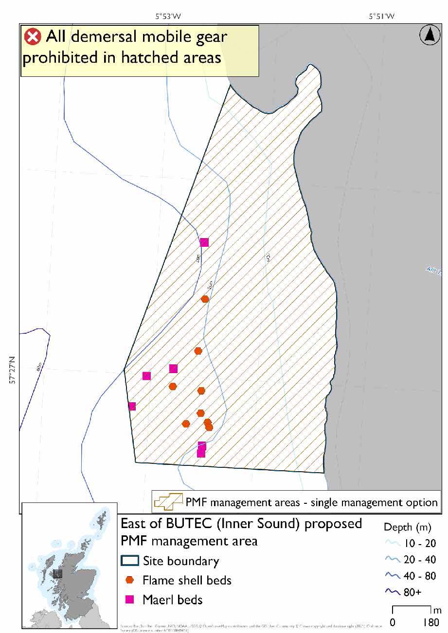
25.20 East of BUTEC (Inner Sound)
25.20.1 Description and background*
East of BUTEC (Inner Sound) proposed PMF management area is a small area located on the coast north of Applecross, and to the east of the British Underwater Test and Evaluation Centre (BUTEC). This area has been selected to protect:
- Flame shell beds; and
- Maerl beds
*This proposed PMF management area overlaps with the Inner Hebrides and the Minches SAC.
25.20.2 Fisheries management measures proposed
PMF management areas will be closed to demersal trawls and seines, beam trawls, mechanical dredges, and hydraulic dredges. This is because the features present in these areas are sensitive to these gear types.
This PMF management area overlaps with management measures being consulted on for Inner Hebrides and the Minches SAC for set nets (not including fyke nets) which are not shown in the map below.
Please check overlapping site map option(s) to see static gear measures.
25.20.3 Options under consideration
A single management option has been developed for this PMF management area. Only one option was identified due to one of, or combination of, evidence (fishing activity or PMF related), boundary setting principles and compliance considerations.
The 2018 area’s boundary was amended to better reflect the distribution of the flame shell bed and maerl bed records. No additional fishing data were provided within the proposed PMF management area.
25.20.4 Other fisheries management measures currently applying to this area
There are already management measures in place. An effort has been made to identify existing measures which affect each individual site or area, however the list may not be exhaustive. These measures are outlined below, and the proposals for further management being consulted on now are in addition to these existing measures:
- Dredge, beam trawl, demersal trawl or demersal seine net is prohibited in part of the area all year
- Suction dredges prohibited all year across part of the area
- 01 October until 31st March Fishing for sea fish with a dredge, beam trawl, demersal trawl or demersal seine net is prohibited across part of the area
- 01 April until 30 September Fishing for sea fish with a dredge, beam trawl, demersal trawl or demersal seine net is prohibited across part of the area. Does not apply to either a fishing boat with a single beam trawl or demersal seine; or from a fishing boat with a registered length less than 12 metres with a single demersal trawl [or] a mechanical dredge
- Fishing for sandeel is prohibited within the Scottish zone, which is defined as the sea adjacent to Scotland up to the 200 nautical miles limit
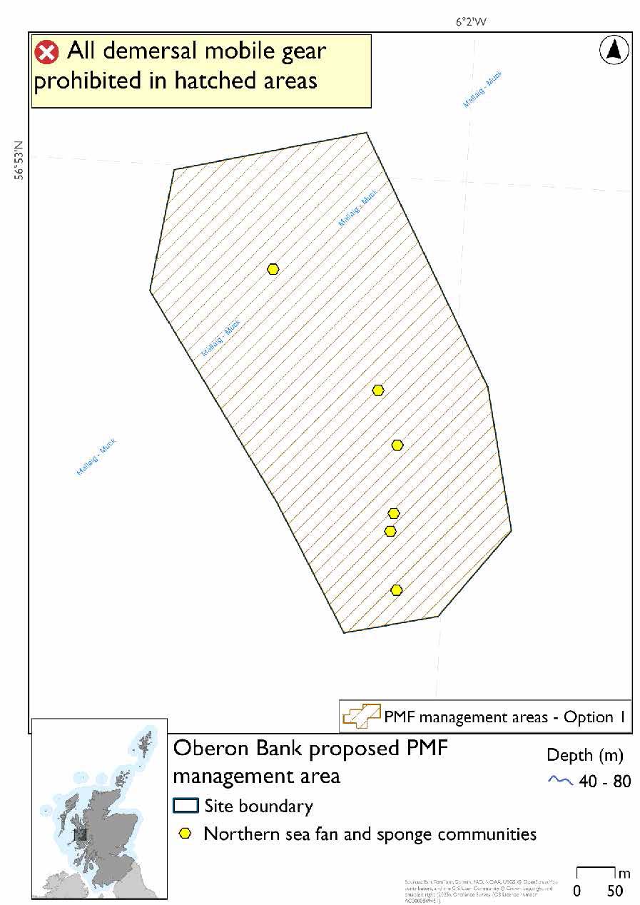
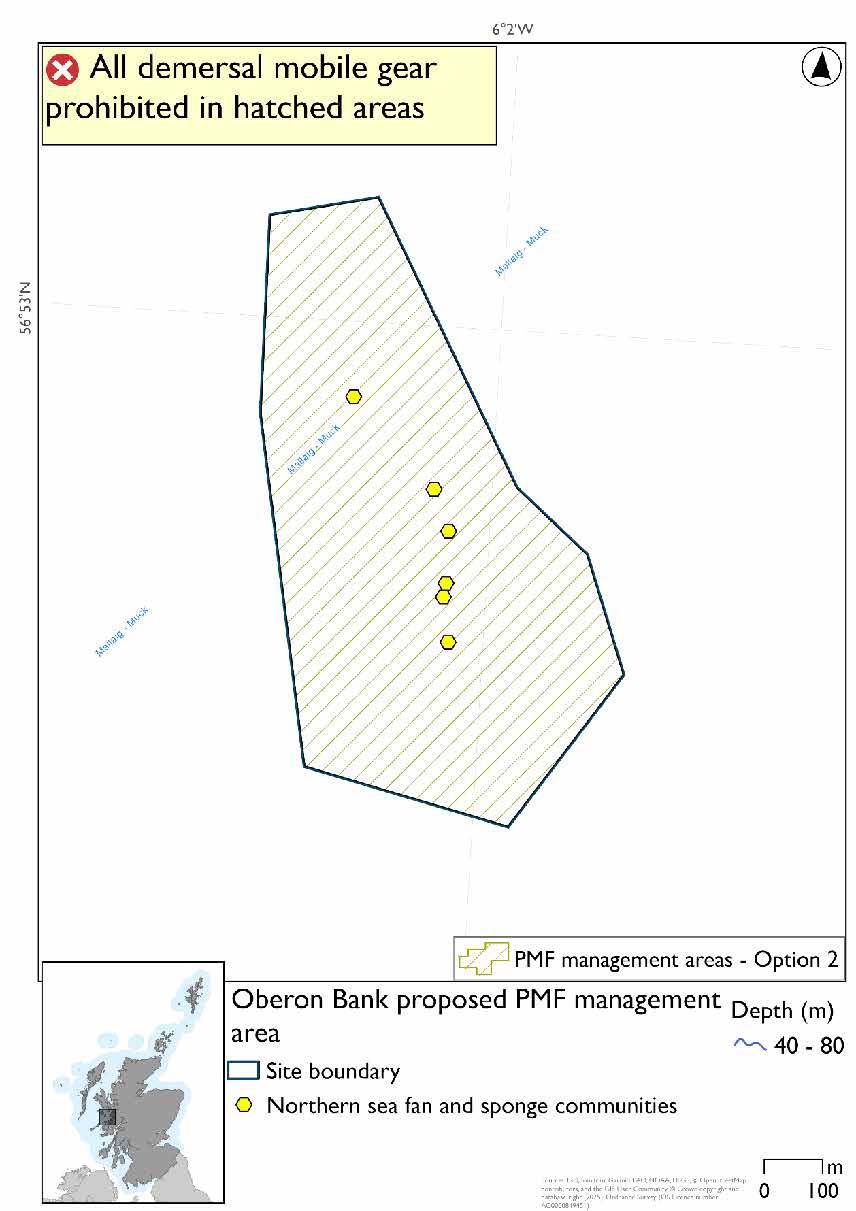
25.21 Oberon Bank*
25.21.1 Description and background
Oberon Bank proposed PMF management area is a small patch of open waters between Eigg and the Scottish mainland. This area has been selected to protect:
- Northern sea fan and sponge communities.
*This proposed PMF management area overlaps with the Sea of the Hebrides NCMPA and Inner Hebrides and the Minches SAC.
25.21.2 Fisheries management measures proposed
PMF management areas will be closed to demersal trawls and seines, beam trawls, mechanical dredges, and hydraulic dredges. This is because the features present in these areas are sensitive to these gear types.
This PMF management area overlaps with management measures being consulted on for Inner Hebrides and the Minches SAC and Sea of the Hebrides NCMPA for set nets (not including fyke nets) which are not shown in the maps below.
Please check one of the overlapping site map option(s) to see static gear measures. Both maps show the same thing for overlapping portion.
25.21.3 Options under consideration
Two options have been developed for this for this PMF management area. Option 1 reflects a smaller footprint that reflects one, or a combination of evidence (fishing activity or PMF related), boundary setting principles and compliance considerations. Option 2 covers a larger footprint that offers improved protection.
No additional fishing data were provided within the proposed PMF management area.
Option 1: This boundary covers a smaller footprint that includes the clusters of PMF records. The 2018 area was reduced due to additional 2019 survey data not finding the habitat in the southeast section of the proposed management area.
Option 2: This boundary covers a larger footprint that offers improved protection.
25.21.4 Other fisheries management measures currently applying to this area
There are already management measures in place. An effort has been made to identify existing measures which affect each individual site or area, however the list may not be exhaustive. These measures are outlined below, and the proposals for further management being consulted on now are in addition to these existing measures:
- Fishing for sandeel is prohibited within the Scottish zone, which is defined as the sea adjacent to Scotland up to the 200 nautical miles limit
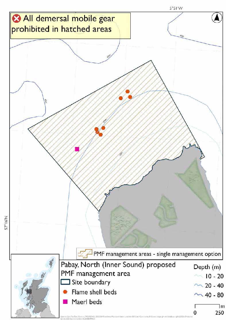
25.22 Pabay, North (Inner Sound)
25.22.1 Description and background*
Pabay, North (Inner Sound) proposed PMF management area covers an area on the northwest coast of Pabay, north of Skye. This area has been selected to protect:
- Flame shell beds; and
- Maerl beds
*This proposed PMF management area overlaps with the Inner Hebrides and the Minches SAC.
25.22.2 Fisheries management measures proposed
PMF management areas will be closed to demersal trawls and seines, beam trawls, mechanical dredges, and hydraulic dredges. This is because the features present in these areas are sensitive to these gear types.
This PMF management area overlaps with management measures being consulted on for Inner Hebrides and the Minches SAC for set nets (not including fyke nets) which are not shown in the map below.
Please check overlapping site map option(s) to see static gear measures.
25.22.3 Options under consideration
A single management option has been developed for this PMF management area. Only one option was identified due to one of, or combination of, evidence (fishing activity or PMF related), boundary setting principles and compliance considerations.
No additional fishing data were provided within the proposed PMF management area.
25.22.4 Other fisheries management measures currently applying to this area
There are already management measures in place. An effort has been made to identify existing measures which affect each individual site or area, however the list may not be exhaustive. These measures are outlined below, and the proposals for further management being consulted on now are in addition to these existing measures:
- Dredge, beam trawl, demersal trawl or demersal seine net is prohibited in part of the area all year
- Suction dredges prohibited all year across part of the area
- 01 October until 31st March Fishing for sea fish with a dredge, beam trawl, demersal trawl or demersal seine net is prohibited across part of the area
- 01 April until 30 September Fishing for sea fish with a dredge, beam trawl, demersal trawl or demersal seine net is prohibited across part of the area. Does not apply to either a fishing boat with a single beam trawl or demersal seine; or from a fishing boat with a registered length less than 12 metres with a single demersal trawl [or] a mechanical dredge
- Fishing for sandeel is prohibited within the Scottish zone, which is defined as the sea adjacent to Scotland up to the 200 nautical miles limit
25.23 Port Erradale (Gairloch)*
25.23.1 Description and background
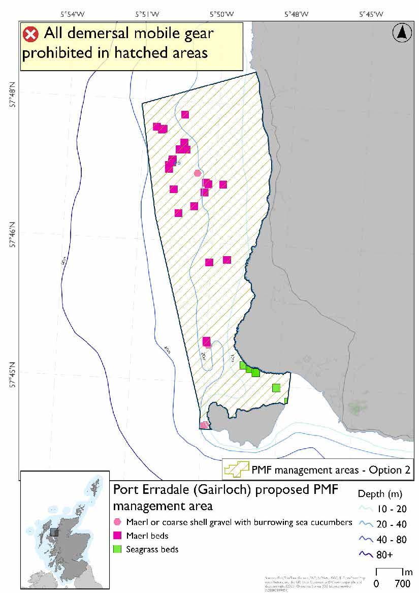
Port Erradale (Gairloch) proposed PMF management area covers the waters around Port Erradale in Gairloch, down to the north coast of Longa. This area has been selected to protect:
- Maerl beds;
- Maerl or coarse shell gravel with burrowing sea cucumbers; and
- Seagrass beds
*This proposed PMF management area overlaps with the Inner Hebrides and the Minches SAC.
25.23.2 Fisheries management measures proposed
PMF management areas will be closed to demersal trawls and seines, beam trawls, mechanical dredges, and hydraulic dredges. This is because the features present in these areas are sensitive to these gear types.
This PMF management area overlaps with management measures being consulted on for Inner Hebrides and the Minches SAC for set nets (not including fyke nets) which are not shown in the maps below.
Please check overlapping site map option(s) to see static gear measures.
25.23.3 Options under consideration
Two options have been developed for this for this PMF management area. Option 1 reflects a smaller footprint that reflects one, or a combination of evidence (fishing activity or PMF related), boundary setting principles and compliance considerations. Option 2 covers a larger footprint that offers improved protection.
Option 2 includes additional maerl bed records in northeastern section, not included in Option 1, as these were from a 2023 survey where data were only available after the area was finalised for consultation.
Option 1: This boundary covers a smaller footprint encompassing the records known at the time of finalising the area for consultation. Additional fishing data were provided and accommodated whilst still protecting the PMF records with buffers.
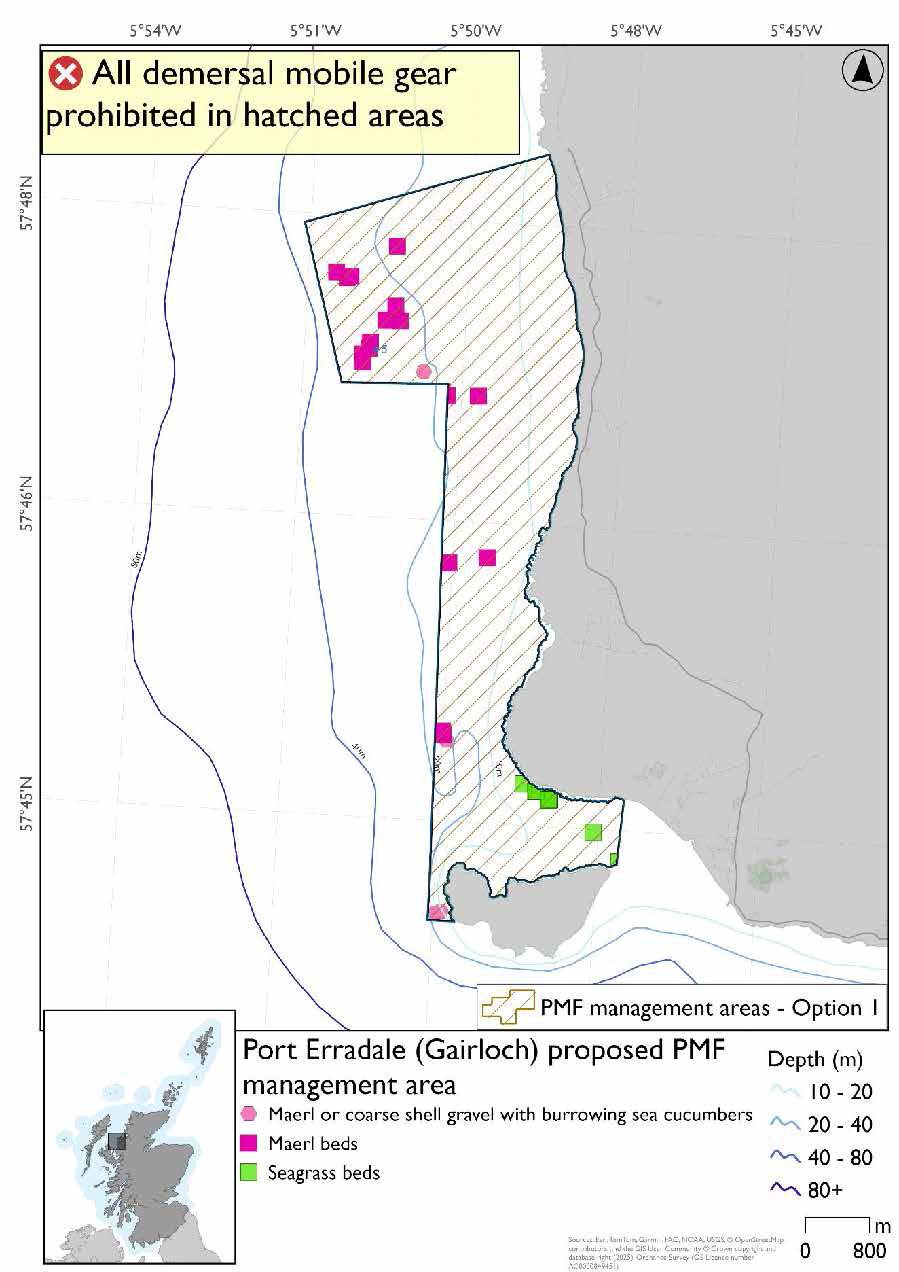
Option 2: This boundary covers a larger footprint incorporating further new maerl bed records from 2023 and additional habitat at depths suitable for this PMF.
25.23.4 Other fisheries management measures currently applying to this area
There are already management measures in place. An effort has been made to identify existing measures which affect each individual site or area, however the list may not be exhaustive. These measures are outlined below, and the proposals for further management being consulted on now are in addition to these existing measures:
- Fishing for sandeel is prohibited within the Scottish zone, which is defined as the sea adjacent to Scotland up to the 200 nautical miles limit
25.24 Red Point (Torridon)
25.24.1 Description and background*
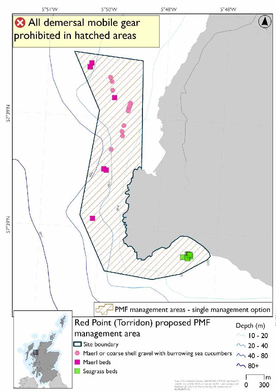
Red Point (Torridon) proposed PMF management area covers the waters surrounding and immediately north of Red Point in Torridon. This area has been selected to protect:
- Maerl beds;
- Maerl or coarse shell gravel with burrowing sea cucumbers; and
- Seagrass beds
*This proposed PMF management area overlaps with the Inner Hebrides and the Minches SAC.
25.24.2 Fisheries management measures proposed
PMF management areas will be closed to demersal trawls and seines, beam trawls, mechanical dredges, and hydraulic dredges. This is because the features present in these areas are sensitive to these gear types.
This PMF management area overlaps with management measures being consulted on for Inner Hebrides and the Minches SAC for set nets (not including fyke nets) which are not shown in the map below.
Please check overlapping site map option(s) to see static gear measures.
25.24.3 Options under consideration
A single management option has been developed for this PMF management area. Only one option was identified due to one of, or combination of, evidence (fishing activity or PMF related), boundary setting principles and compliance considerations.
The boundary of the 2018 area was extended in the north to include additional PMF records and straightened in the south. No additional fishing data were provided within the proposed PMF management area.
25.24.4 Other fisheries management measures currently applying to this area
There are already management measures in place. An effort has been made to identify existing measures which affect each individual site or area, however the list may not be exhaustive. These measures are outlined below, and the proposals for further management being consulted on now are in addition to these existing measures:
- Fishing for sandeel is prohibited within the Scottish zone, which is defined as the sea adjacent to Scotland up to the 200 nautical miles limit
25.25 Rubha Chuaig (Inner Sound)
25.25.1 Description and background*
Rubha Chuaig (Inner Sound) proposed PMF management area covers an area of coast south of the mouth of Loch Torridon. This area has been selected to protect:
- Flame shell beds: and
- Maerl beds
There are also maerl or coarse shell gravel with burrowing sea cucumber records present, but they were not a focus for this area’s selection.
*This proposed PMF management area overlaps with the Inner Hebrides and the Minches SAC.
25.25.2 Fisheries management measures proposed
PMF management areas will be closed to demersal trawls and seines, beam trawls, mechanical dredges, and hydraulic dredges. This is because the features present in these areas are sensitive to these gear types.
This PMF management area overlaps with management measures being consulted on for Inner Hebrides and the Minches SAC for set nets (not including fyke nets) which are not shown in the map below.
Please check overlapping site map option(s) to see static gear measures.
25.25.3 Options under consideration
A single management option has been developed for this PMF management area. Only one option was identified due to one of, or combination of, evidence (fishing activity or PMF related), boundary setting principles and compliance considerations.
The boundary of the 2018 area was amended to better reflect the extent of the PMF records. Additional fishing data were provided and accommodated whilst taking into account depth requirements for maerl beds and sufficient buffers around known records.
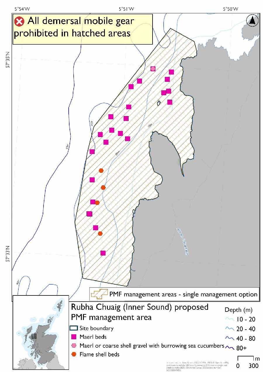
*A maerl and coarse shell gravel with burrowing sea cucumbers record is present on top of the most northern maerl bed record.
25.25.4 Other fisheries management measures currently applying to this area
There are already management measures in place. An effort has been made to identify existing measures which affect each individual site or area, however the list may not be exhaustive. These measures are outlined below, and the proposals for further management being consulted on now are in addition to these existing measures:
- Trawls and suction dredges prohibited all year round in part of the area
- Fishing for sea fish with mobile or active gear prohibited from 01 October till 31 March each year in part of the area
- Fishing for sandeel is prohibited within the Scottish zone, which is defined as the sea adjacent to Scotland up to the 200 nautical miles limit
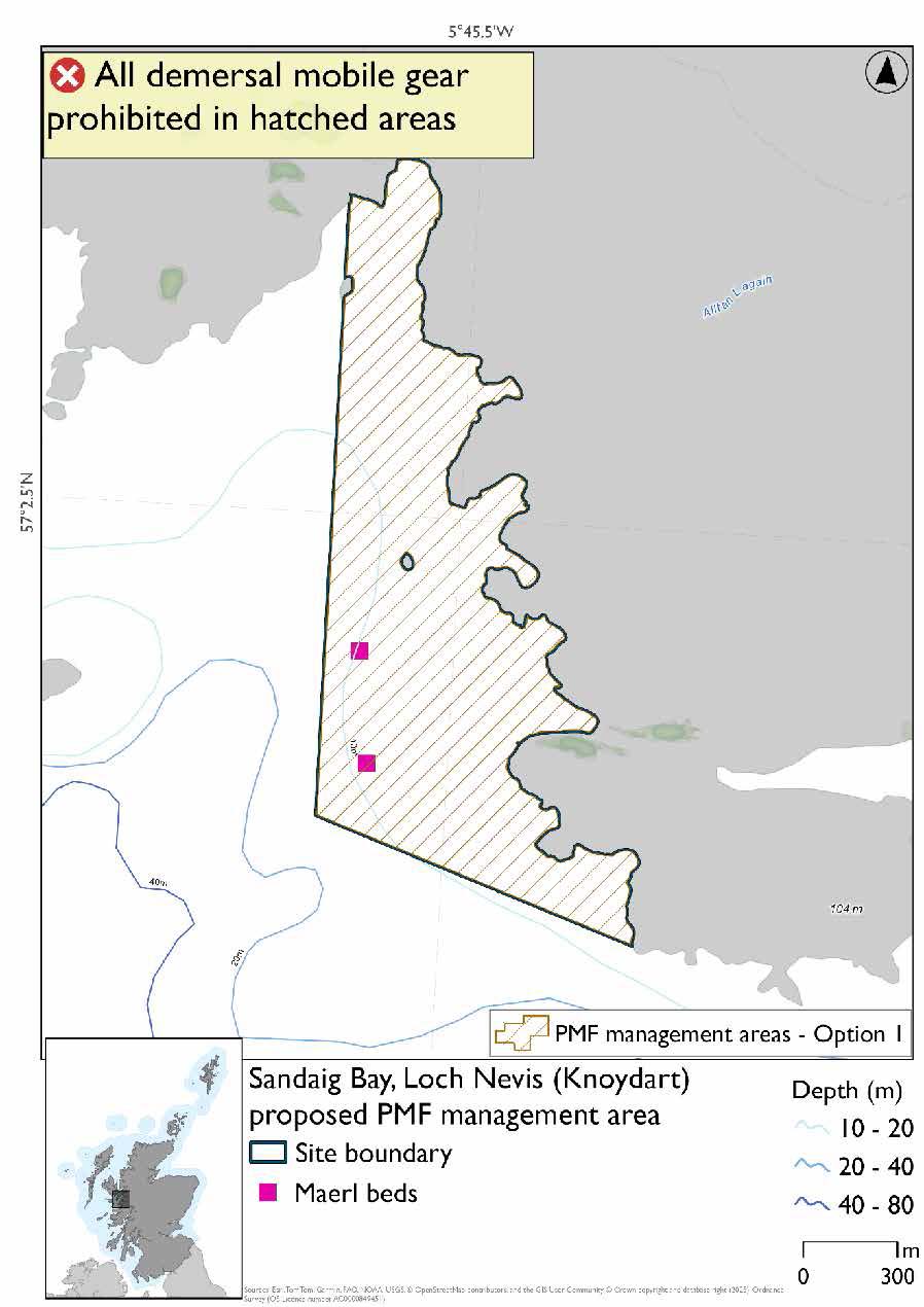
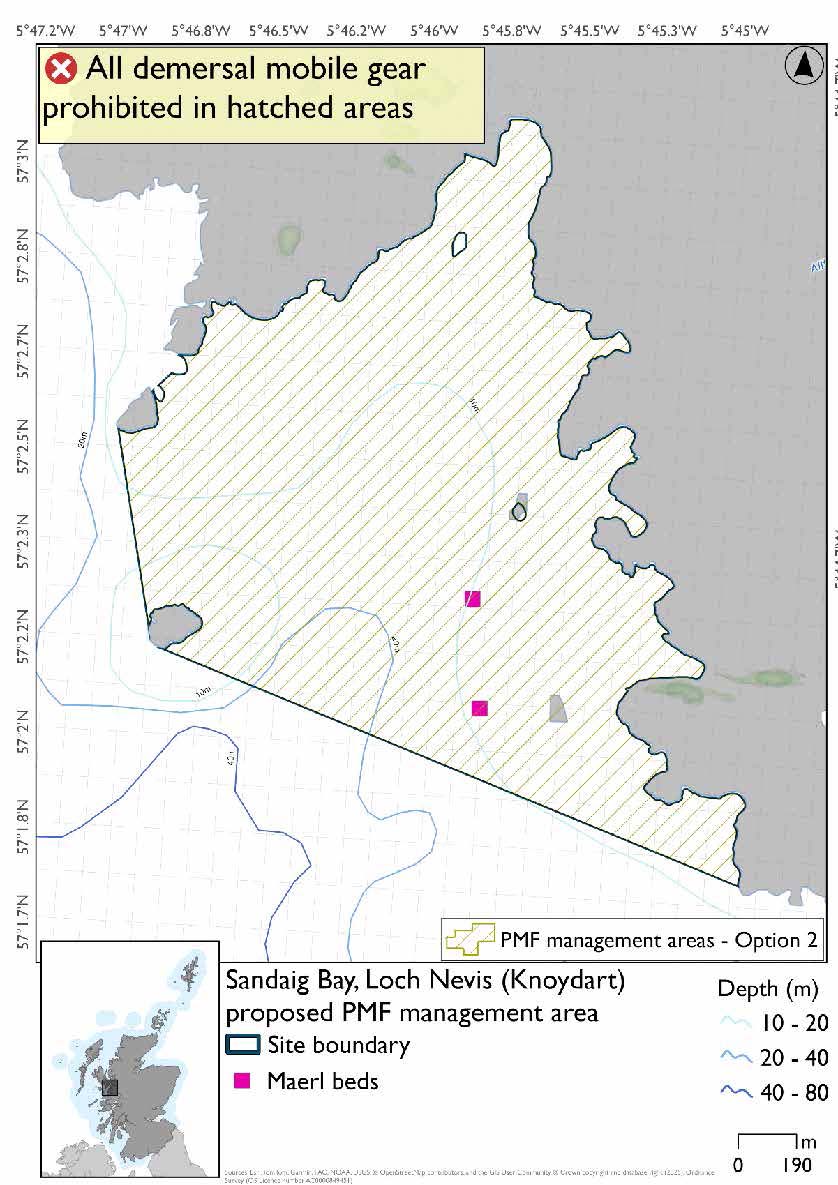
25.26 Sandaig Bay, Loch Nevis (Knoydart)*
25.26.1 Description and background
Sandaig Bay, Loch Nevis (Knoydart) proposed PMF management area covers the whole of Sandaig Bay at the mouth of Loch Nevis. This area has been selected to protect:
- Maerl beds
*This proposed PMF management area overlaps with the Inner Hebrides and the Minches SAC.
25.26.2 Fisheries management measures proposed
PMF management areas will be closed to demersal trawls and seines, beam trawls, mechanical dredges, and hydraulic dredges. This is because the features present in these areas are sensitive to these gear types.
This PMF management area overlaps with management measures being consulted on for Inner Hebrides and the Minches SAC for set nets (not including fyke nets) which are not shown in the maps below. Please check overlapping site map option(s) to see static gear measures.
25.26.3 Options under consideration
Two options have been developed for this for this PMF management area. Option 1 reflects a smaller footprint that reflects one, or a combination of evidence (fishing activity or PMF related), boundary setting principles and compliance considerations. Option 2 covers a larger footprint that offers improved protection.
There is an additional maerl bed record outside of the boundary to the south, this is not shown in either Option because this was from a 2023 survey where data were only available after the area was finalised for consultation.
Option 1: This boundary covers a smaller footprint that includes known maerl bed records at the time of finalising the area for consultation and follows suitable depths for the habitat. Additional fishing data were provided and accommodated whilst still protecting the PMF records with buffers.
Option 2: This boundary covers a larger footprint that includes additional habitat of suitable depth in the west.
25.26.4 Other fisheries management measures currently applying to this area
There are already management measures in place. An effort has been made to identify existing measures which affect each individual site or area, however the list may not be exhaustive. These measures are outlined below, and the proposals for further management being consulted on now are in addition to these existing measures:
- Fishing for sandeel is prohibited within the Scottish zone, which is defined as the sea adjacent to Scotland up to the 200 nautical miles limit
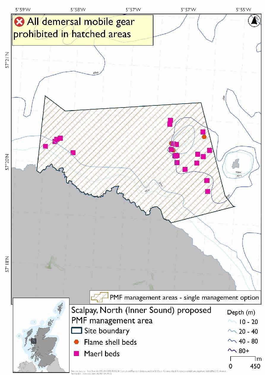
25.27 Scalpay, North (Inner Sound)
25.27.1 Description and background*
Scalpay, North (Inner Sound) proposed PMF management area covers an area off the north coast of Scalpay, north of Skye. This area has been selected to protect:
- Flame shell beds; and
- Maerl beds
*This proposed PMF management area overlaps with the Inner Hebrides and the Minches SAC.
25.27.2 Fisheries management measures proposed
PMF management areas will be closed to demersal trawls and seines, beam trawls, mechanical dredges, and hydraulic dredges. This is because the features present in these areas are sensitive to these gear types.
This PMF management area overlaps with management measures being consulted on for Inner Hebrides and the Minches SAC for set nets (not including fyke nets) which are not shown in the map below.
Please check overlapping site map option(s) to see static gear measures.
25.27.3 Options under consideration
A single management option has been developed for this PMF management area. Only one option was identified due to one of, or combination of, evidence (fishing activity or PMF related), boundary setting principles and compliance considerations.
The boundary of the 2018 area was amended to take account of Red Rocks and Longay MPA where additional maerl bed and flame shell bed records are protected. Additional fishing data were provided but the distribution of records in relation to these data meant no other changes were necessary.
25.27.4 Other fisheries management measures currently applying to this area
There are already management measures in place. An effort has been made to identify existing measures which affect each individual site or area, however the list may not be exhaustive. These measures are outlined below, and the proposals for further management being consulted on now are in addition to these existing measures:
- Dredge, beam trawl, demersal trawl or demersal seine net is prohibited in part of the area all year
- Suction dredges prohibited all year across part of the area
- 01 October until 31st March Fishing for sea fish with a dredge, beam trawl, demersal trawl or demersal seine net is prohibited across part of the area
- 01 April until 30 September Fishing for sea fish with a dredge, beam trawl, demersal trawl or demersal seine net is prohibited across part of the area. Does not apply to either a fishing boat with a single beam trawl or demersal seine; or from a fishing boat with a registered length less than 12 metres with a single demersal trawl [or] a mechanical dredge
- Fishing for sandeel is prohibited within the Scottish zone, which is defined as the sea adjacent to Scotland up to the 200 nautical miles limit
25.28 South of Muck and Bo Fascadale*
25.27.1 Description and background
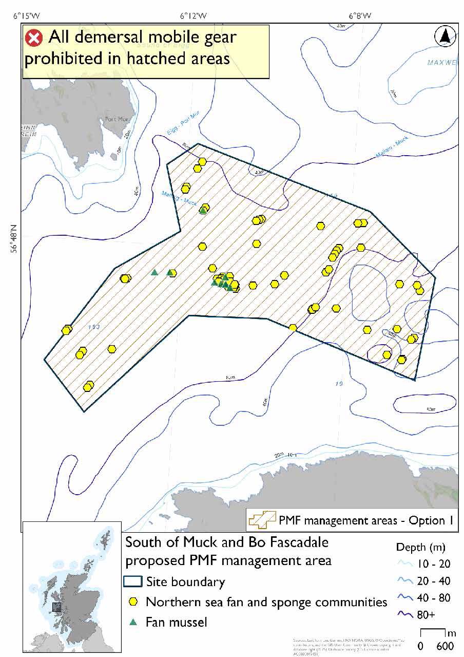
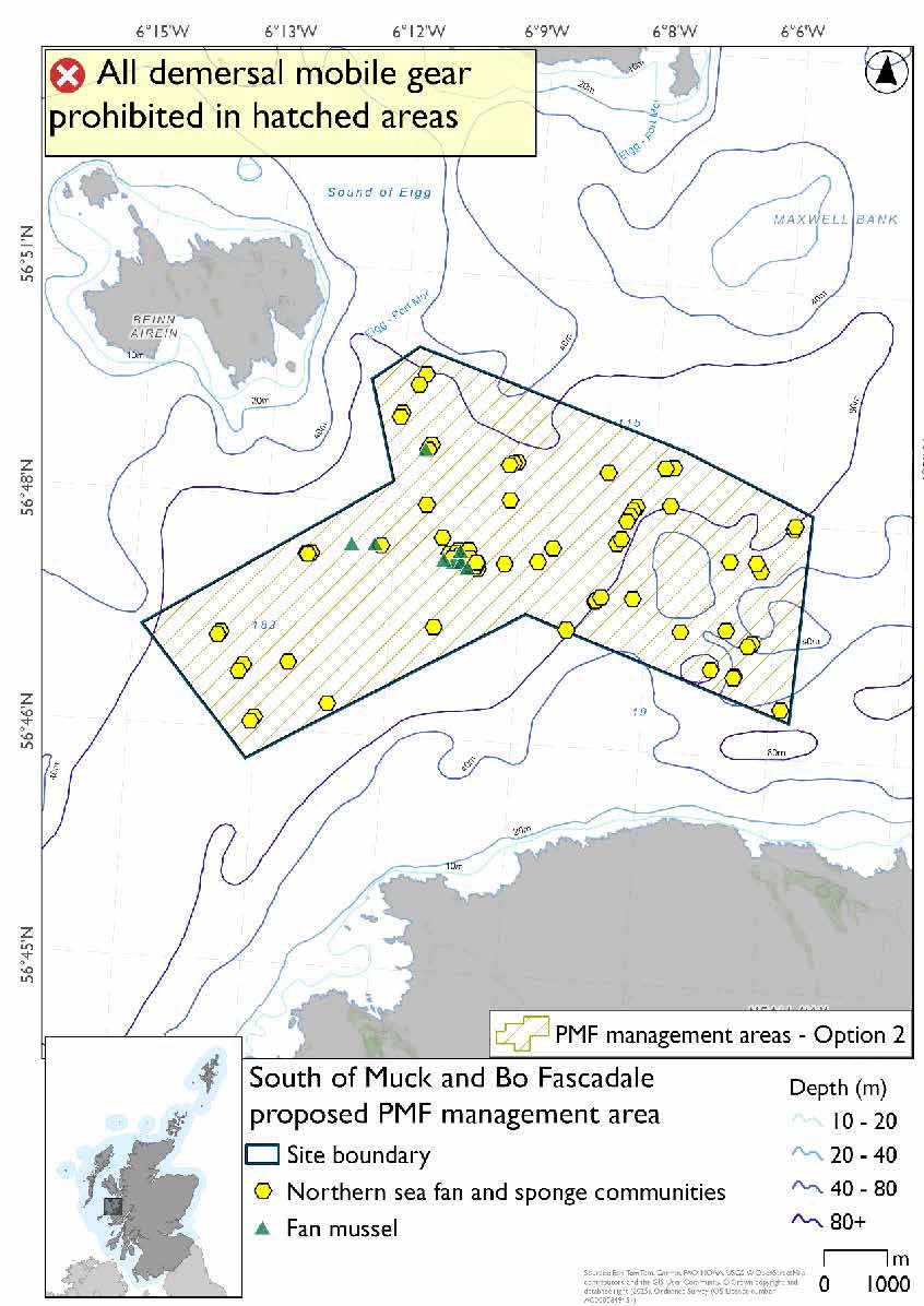
South of Muck and Bo Fascadale proposed PMF management area covers an area north of the Ardnamurchan peninsula, and south of Muck and Eigg. This area has been selected to protect:
- Fan mussel aggregations; and
- Northern sea fan and sponge communities.
*This proposed PMF management area overlaps with the Sea of the Hebrides NCMPA and Inner Hebrides and the Minches SAC.
25.27.2 Fisheries management measures proposed
PMF management areas will be closed to demersal trawls and seines, beam trawls, mechanical dredges, and hydraulic dredges. This is because the features present in these areas are sensitive to these gear types.
This PMF management area overlaps with management measures being consulted on for Inner Hebrides and the Minches SAC and Sea of the Hebrides NCMPA for set nets (not including fyke nets) which are not shown in the maps below.
Please check one of the overlapping site map option(s) to see static gear measures. Both maps show the same thing for overlapping portion.
25.27.3 Options under consideration
Two options have been developed for this for this PMF management area. Option 1 reflects a smaller footprint that reflects one, or a combination of evidence (fishing activity or PMF related), boundary setting principles and compliance considerations. Option 2 covers a larger footprint that offers improved protection.
Two management areas from 2018 were joined to make this area based on new records of northern sea fan and sponge communities in this locality.
Option 2 has northern sea fan and sponge communities that were not included in Option 1. The area excluded overlaps with additional fishing data that were provided and any excluded northern sea fan and sponge communities records.
Option 1: This boundary covers a smaller footprint that excludes a few northern sea fan and sponge communities records around the margins accommodating, where possible, additional fishing data that were provided.
Option 2: This boundary covers a larger footprint that includes additional records of northern sea fan and sponge communities.
25.27.4 Other fisheries management measures currently applying to this area
There are already management measures in place. An effort has been made to identify existing measures which affect each individual site or area, however the list may not be exhaustive. These measures are outlined below, and the proposals for further management being consulted on now are in addition to these existing measures:
- Fishing for sandeel is prohibited within the Scottish zone, which is defined as the sea adjacent to Scotland up to the 200 nautical miles limit
25.28 Sgeir na Sean Chroit (Upper Loch Linnhe)
25.28.1 Description and background
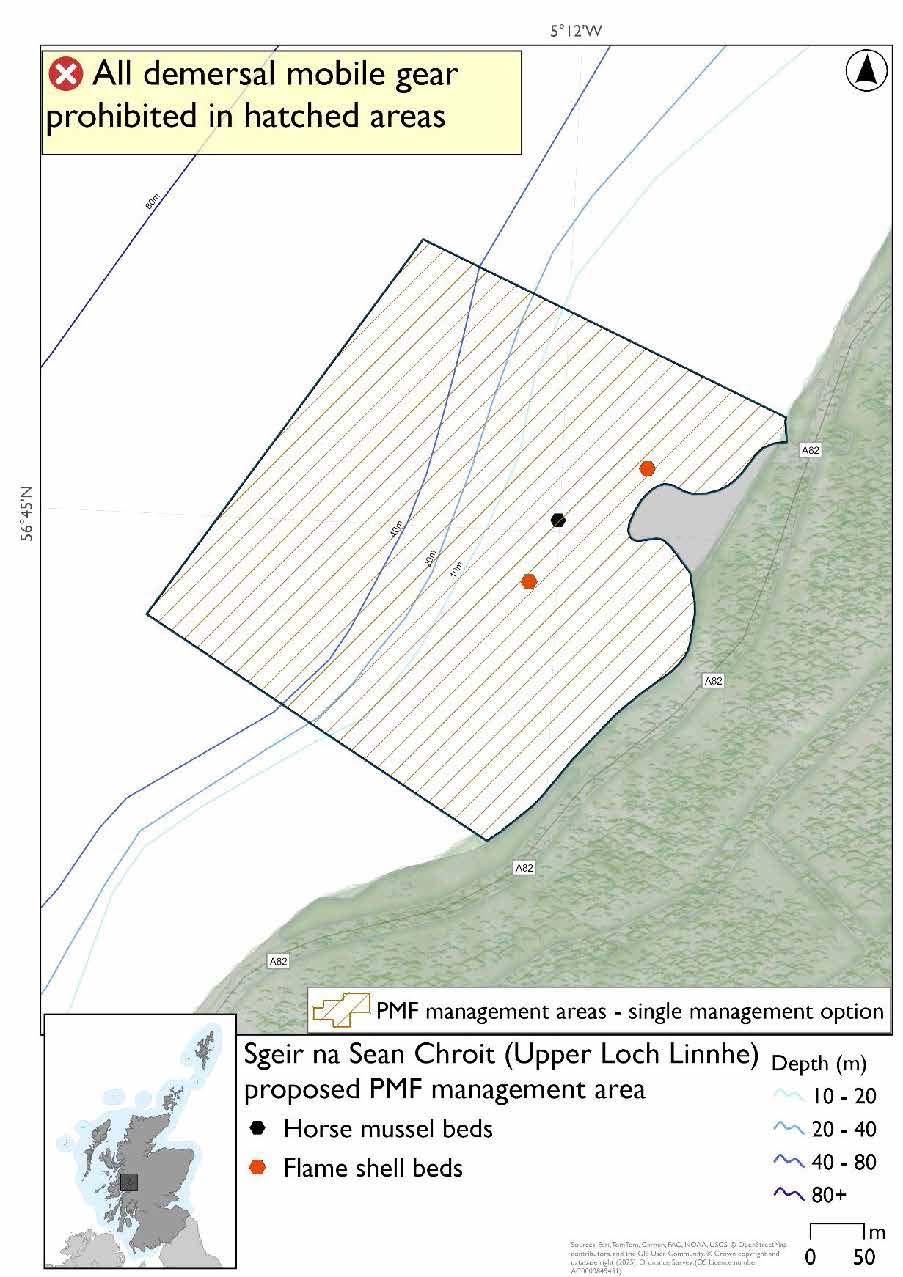
Sgeir na Sean Chroit (Upper Loch Linnhe) proposed PMF management area covers an area some 400 metres across on the southern coast of Loch Linnhe northeast of Corran. This area has been selected to protect:
- Flame shell beds; and
- Horse mussel beds
25.28.2 Fisheries management measures proposed
PMF management areas will be closed to demersal trawls and seines, beam trawls, mechanical dredges, and hydraulic dredges. This is because the features present in these areas are sensitive to these gear types.
25.28.3 Options under consideration
A single management option has been developed for this PMF management area. Only one option was identified due to one of, or combination of, evidence (fishing activity or PMF related), boundary setting principles and compliance considerations.
This option reflects the extent of the current survey data and is situated on a steeply sloping seabed that extends to depths that are suitable for horse mussel beds. No additional fishing data were provided within the proposed PMF management area.
25.28.4 Other fisheries management measures currently applying to this area
There are already management measures in place. An effort has been made to identify existing measures which affect each individual site or area, however the list may not be exhaustive. These measures are outlined below, and the proposals for further management being consulted on now are in addition to these existing measures:
- Fishing for sandeel is prohibited within the Scottish zone, which is defined as the sea adjacent to Scotland up to the 200 nautical miles limit
25.29 Pabay, South-West (Inner Sound)
25.29.1 Description and background*
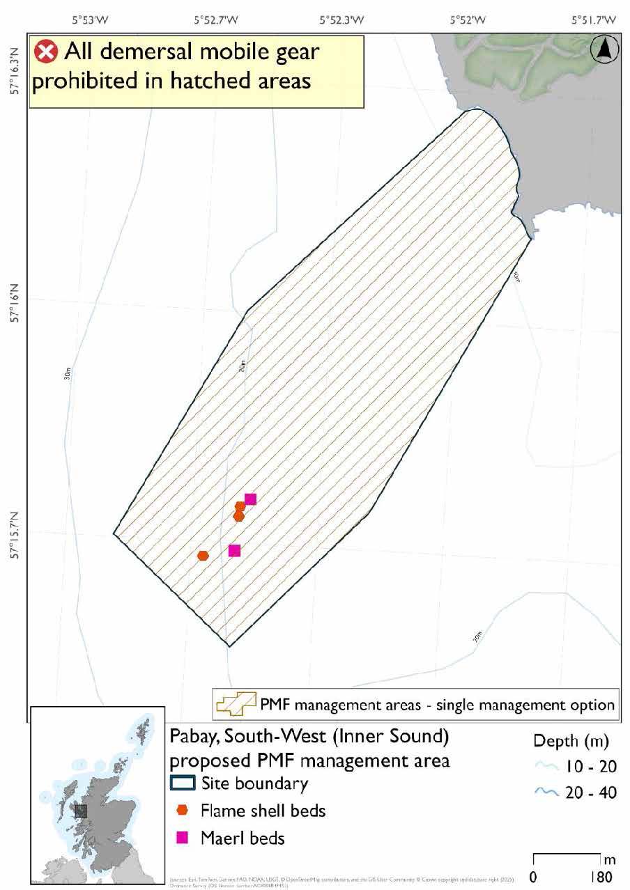
Pabay, South-West (Inner Sound) proposed PMF management area covers an elongated stretch of waters extending from the southwest coast of Pabay, north of Skye. This area has been selected to protect:
- Flame shell beds; and
- Maerl beds
*This proposed PMF management area overlaps with the Inner Hebrides and the Minches SAC.
25.29.2 Fisheries management measures proposed
PMF management areas will be closed to demersal trawls and seines, beam trawls, mechanical dredges, and hydraulic dredges. This is because the features present in these areas are sensitive to these gear types.
This PMF management area overlaps with management measures being consulted on for Inner Hebrides and the Minches SAC for set nets (not including fyke nets) which are not shown in the map below.
Please check overlapping site map option(s) to see static gear measures.
25.29.3 Options under consideration
A single management option has been developed for this PMF management area. Only one option was identified due to one of, or combination of, evidence (fishing activity or PMF related), boundary setting principles and compliance considerations.
No additional fishing data were provided within the proposed PMF management area.
25.29.4 Other fisheries management measures currently applying to this area
There are already management measures in place. An effort has been made to identify existing measures which affect each individual site or area, however the list may not be exhaustive. These measures are outlined below, and the proposals for further management being consulted on now are in addition to these existing measures:
- Dredge, beam trawl, demersal trawl or demersal seine net is prohibited in part of the area all year
- Suction dredges prohibited all year across part of the area
- 01 October until 31st March Fishing for sea fish with a dredge, beam trawl, demersal trawl or demersal seine net is prohibited across part of the area
- 01 April until 30 September Fishing for sea fish with a dredge, beam trawl, demersal trawl or demersal seine net is prohibited across part of the area. Does not apply to either a fishing boat with a single beam trawl or demersal seine; or from a fishing boat with a registered length less than 12 metres with a single demersal trawl [or] a mechanical dredge
- Fishing for sandeel is prohibited within the Scottish zone, which is defined as the sea adjacent to Scotland up to the 200 nautical miles limit
Contact
Email: marine_biodiversity@gov.scot