
Fisheries Management Measures within Scottish Inshore Marine Protected Areas (MPAs) and Proposed Priority Marine Feature (PMF) Management Areas - Site and Area Proposal Document
This document describes the process, justification and evidence used to develop site and area specific fisheries management measures. It outlines key information for each site and area including their features, and risks of potential pressures.

24. Proposed PMF management areas in the Shetland Isles marine region
24.1 Back of Ollaberry, Yell Sound (Shetland)
24.1.1Description and background
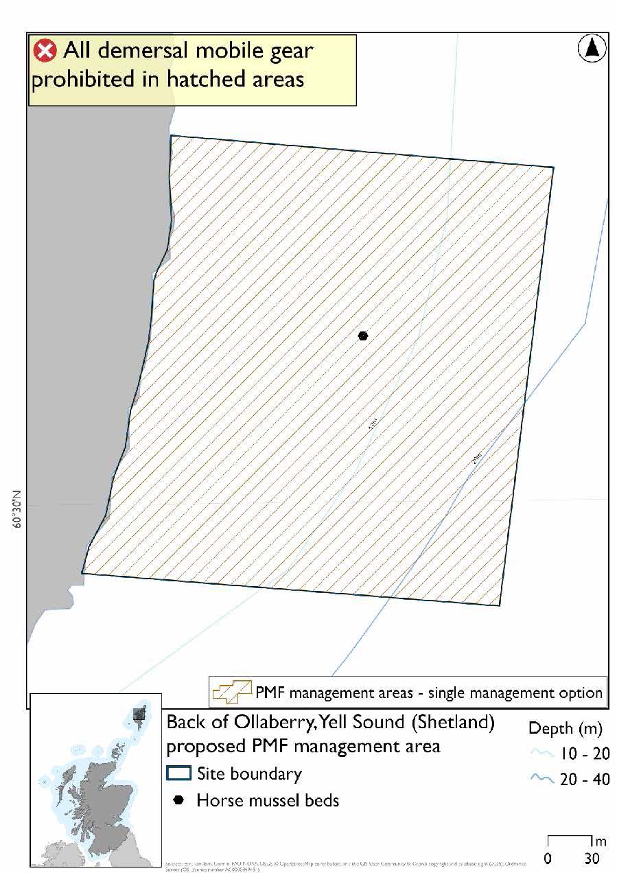
Back of Ollaberry, Yell Sound (Shetland) proposed PMF management area covers a small area of waters at the tip of the peninsula just north of Ollaberry. This area has been selected to protect:
- Horse mussel beds
24.1.2 Fisheries management measures proposed
PMF management areas will be closed to demersal trawls and seines, beam trawls, mechanical dredges, and hydraulic dredges. This is because the features present in these areas are sensitive to these gear types.
24.1.3 Options under consideration
A single management option has been developed for this PMF management area. Only one option was identified due to one of, or combination of, evidence (fishing activity or PMF related), boundary setting principles and compliance considerations.
This was developed to include known horse mussel bed records and to accommodate additional fishing data provided.
24.1.4 Other fisheries management measures currently applying to this area
There are already management measures in place. An effort has been made to identify existing measures which affect each individual site or area, however the list may not be exhaustive. These measures are outlined below, and the proposals for further management being consulted on now are in addition to these existing measures:
- Fishing for sandeel is prohibited within the Scottish zone, which is defined as the sea adjacent to Scotland up to the 200 nautical miles limit
24.2 Busta Voe (Shetland)
24.2.1 Description and background
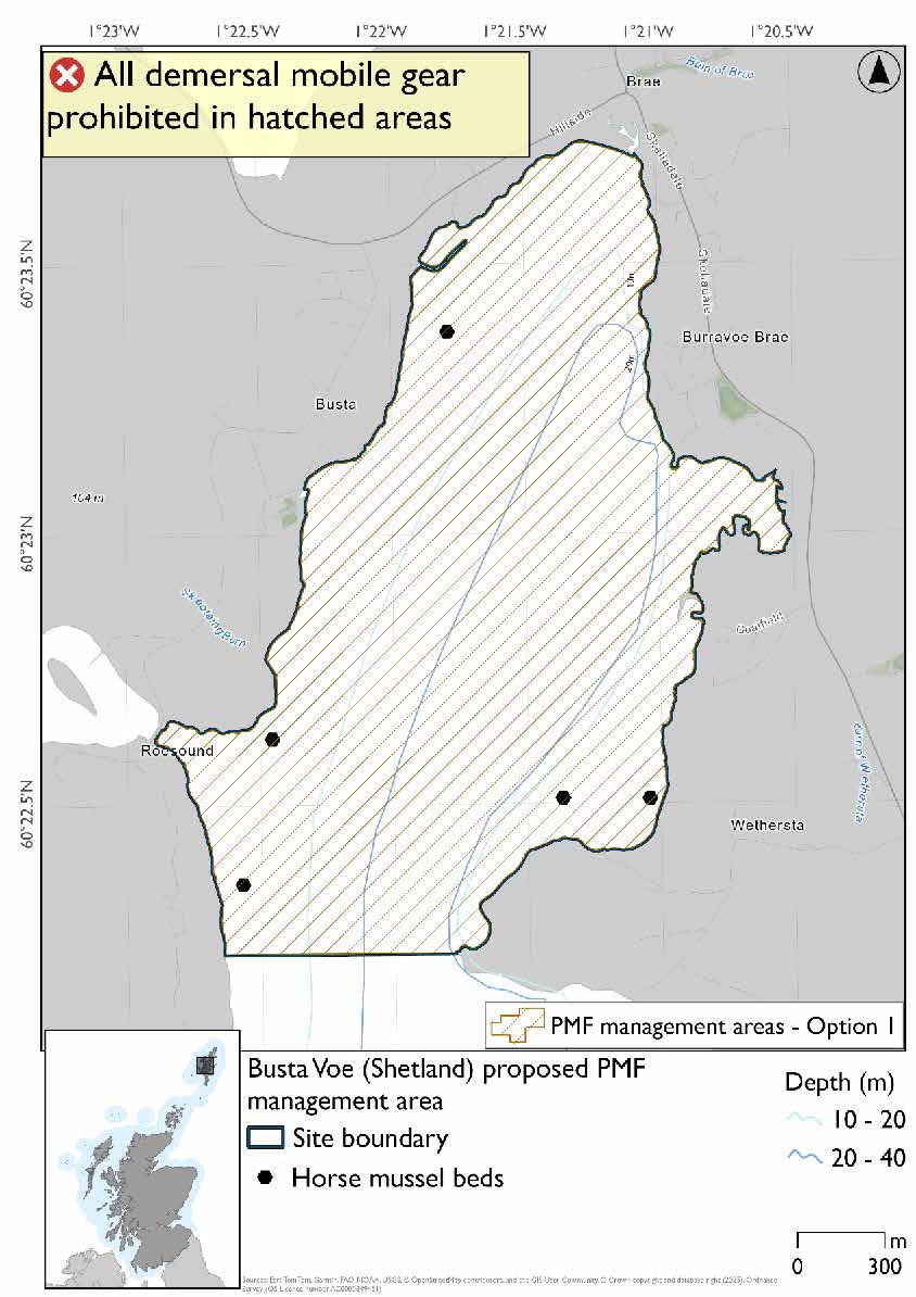
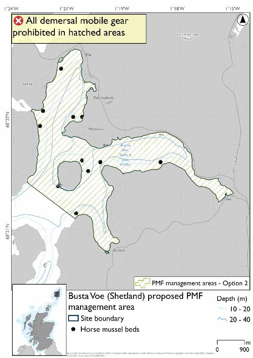
Busta Voe (Shetland) proposed PMF management area covers the waters of Busta Voe, Olna Firth, and Gon Firth and the waters surrounding Linga. This area has been selected to protect:
- Horse mussel beds
24.2.2 Fisheries management measures proposed
PMF management areas will be closed to demersal trawls and seines, beam trawls, mechanical dredges, and hydraulic dredges. This is because the features present in these areas are sensitive to these gear types.
24.2.3 Options under consideration
Two options have been developed for this for this PMF management area. Option 1 reflects a smaller footprint that reflects one, or a combination of evidence (fishing activity or PMF related), boundary setting principles and compliance considerations. Option 2 covers a larger footprint that offers improved protection.
There are records included in Option 2 that are not included in Option 1 due to the age of the records. No additional fishing data were provided within the proposed PMF management area.
Option 1: Developed around records with newer dates. Is larger than, but includes SSMO closures.
Option 2: This boundary covers a larger footprint that offers improved protection and includes older records.
24.2.4 Other fisheries management measures currently applying to this area
There are already management measures in place. An effort has been made to identify existing measures which affect each individual site or area, however the list may not be exhaustive. These measures are outlined below, and the proposals for further management being consulted on now are in addition to these existing measures:
- Under the Shetland Regulating Order scallop dredging prohibited in part of the area
- Fishing for sandeel is prohibited within the Scottish zone, which is defined as the sea adjacent to Scotland up to the 200 nautical miles limit
24.3 Lunna Ness, North (Shetland)
24.3.1 Description and background*
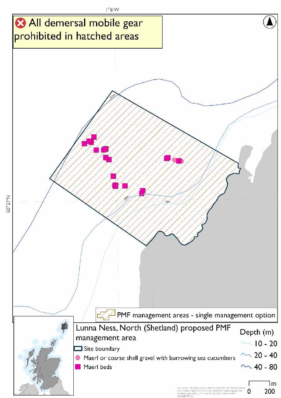
Lunna Ness, North (Shetland) proposed PMF management area covers a small area of waters on the north coast of Lunna Ness. This area has been selected to protect:
- Maerl beds
There are also maerl or coarse shell gravel with burrowing sea cucumber records present, but they were not a focus for this area selection.
*This proposed PMF management area overlaps with the Yell Sound Coast SAC and East Mainland Coast, Shetland SPA.
24.3.2 Fisheries management measures proposed
PMF management areas will be closed to demersal trawls and seines, beam trawls, mechanical dredges, and hydraulic dredges. This is because the features present in these areas are sensitive to these gear types.
This PMF management area overlaps with management measures being consulted on for East Mainland Coast SPA for set nets (including fyke nets) and Yell Sound Coast SAC for set nets (including fyke nets) and pelagic seine (including ring-nets) which are not shown in the map below.
Please check overlapping site map option(s) to see static and pelagic gear measures.
24.3.3 Options under consideration
A single management option has been developed for this PMF management area. Only one option was identified due to one of, or combination of, evidence (fishing activity or PMF related), boundary setting principles and compliance considerations.
This was developed to encompass known records and the depth preferences of maerl in Shetland and to accommodate additional fishing data provided.
24.3.4 Other fisheries management measures currently applying to this area
There are already management measures in place. An effort has been made to identify existing measures which affect each individual site or area, however the list may not be exhaustive. These measures are outlined below, and the proposals for further management being consulted on now are in addition to these existing measures:
- Fishing for sandeel is prohibited within the Scottish zone, which is defined as the sea adjacent to Scotland up to the 200 nautical miles limit
24.4 Linga Sound (Shetland)
24.4.1 Description and background
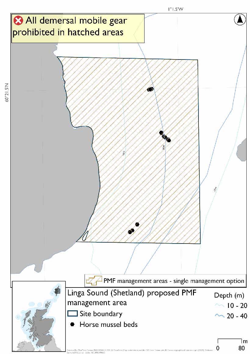
Linga Sound (Shetland) proposed PMF management area covers an area on the southern portion of the east coast of West Linga. This area has been selected to protect:
- Horse mussel beds
24.4.2 Fisheries management measures proposed
PMF management areas will be closed to demersal trawls and seines, beam trawls, mechanical dredges, and hydraulic dredges. This is because the features present in these areas are sensitive to these gear types.
24.4.3 Options under consideration
A single management option has been developed for this PMF management area. Only one option was identified due to one of, or combination of, evidence (fishing activity or PMF related), boundary setting principles and compliance considerations.
No additional fishing data were provided within the proposed PMF management area.
The boundary was drawn around the majority of known horse mussel bed records at the time of the areas were being finalised for consultation. We are aware there are additional horse mussel bed records to the south of the area that were part of North Atlantic Fisheries College (NAFC) Marine Centre University of the Highlands and Islands (UHI), Shetland survey in 2019 but were not in GeMS when areas were developed.
24.4.4 Other fisheries management measures currently applying to this area
There are already management measures in place. An effort has been made to identify existing measures which affect each individual site or area, however the list may not be exhaustive. These measures are outlined below, and the proposals for further management being consulted on now are in addition to these existing measures:
- Fishing for sandeel is prohibited within the Scottish zone, which is defined as the sea adjacent to Scotland up to the 200 nautical miles limit
24.5 Lunning Sound (Shetland)
24.5.1 Description and background
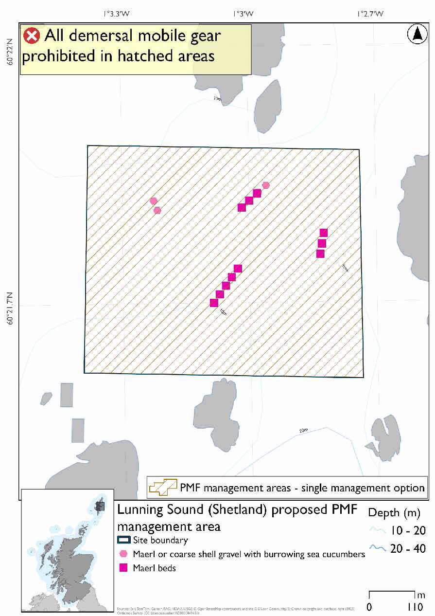
Lunning Sound (Shetland) proposed PMF management area covers an area of waters between the islets in Lunning Sound between the Shetland mainland and West Linga. This area has been selected to protect:
- Maerl beds
- Maerl or coarse shell gravel with burrowing sea cucumbers
24.5.2 Fisheries management measures proposed
PMF management areas will be closed to demersal trawls and seines, beam trawls, mechanical dredges, and hydraulic dredges. This is because the features present in these areas are sensitive to these gear types.
24.5.3 Options under consideration
A single management option has been developed for this PMF management area. Only one option was identified due to one of, or combination of, evidence (fishing activity or PMF related), boundary setting principles and compliance considerations.
The boundary was drawn around known maerl bed records. No additional fishing data were provided within the proposed PMF management area. The boundary matches the existing SSMO closure.
24.5.4 Other fisheries management measures currently applying to this area
There are already management measures in place. An effort has been made to identify existing measures which affect each individual site or area, however the list may not be exhaustive. These measures are outlined below, and the proposals for further management being consulted on now are in addition to these existing measures:
- Under the Shetland Regulating Order scallop dredging prohibited in the area
- Fishing for sandeel is prohibited within the Scottish zone, which is defined as the sea adjacent to Scotland up to the 200 nautical miles limit
24.6 Papa, North (Shetland)
24.6.1 Description and background
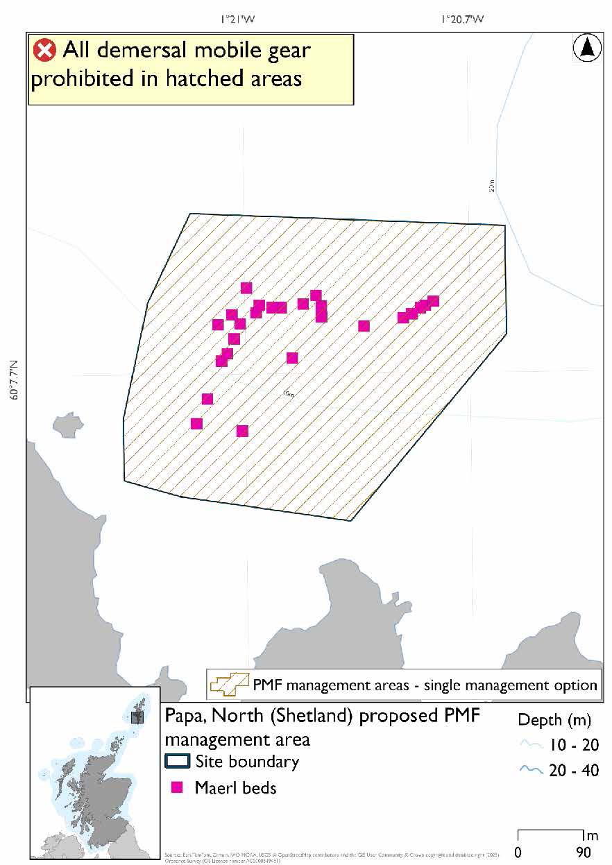
Papa, North (Shetland) proposed PMF management area covers a patch of water just north of Papa, to the west of the Shetland mainland. This area has been selected to protect:
- Maerl beds
24.6.2 Fisheries management measures proposed
PMF management areas will be closed to demersal trawls and seines, beam trawls, mechanical dredges, and hydraulic dredges. This is because the features present in these areas are sensitive to these gear types.
24.6.3 Options under consideration
A single management option has been developed for this PMF management area. Only one option was identified due to one of, or combination of, evidence (fishing activity or PMF related), boundary setting principles and compliance considerations.
The boundary was drawn around known maerl bed records. No additional fishing data were provided within the proposed PMF management area.
24.6.4 Other fisheries management measures currently applying to this area
There are already management measures in place. An effort has been made to identify existing measures which affect each individual site or area, however the list may not be exhaustive. These measures are outlined below, and the proposals for further management being consulted on now are in addition to these existing measures:
- Fishing for sandeel is prohibited within the Scottish zone, which is defined as the sea adjacent to Scotland up to the 200 nautical miles limit
24.7 Quey Firth (Shetland)
24.7.1 Description and background
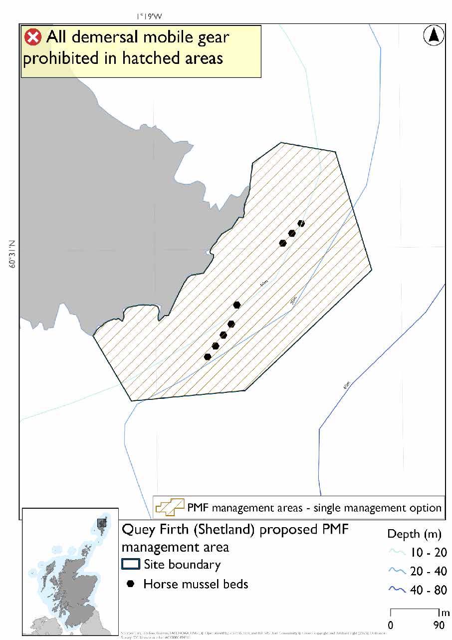
Quey Firth (Shetland) proposed PMF management area covers a small patch of water at the northern end of the mouth of the Quey firth. This area has been selected to protect:
- Horse mussel beds
24.7.2 Fisheries management measures proposed
PMF management areas will be closed to demersal trawls and seines, beam trawls, mechanical dredges, and hydraulic dredges. This is because the features present in these areas are sensitive to these gear types.
24.7.3 Options under consideration
A single management option has been developed for this PMF management area. Only one option was identified due to one of, or combination of, evidence (fishing activity or PMF related), boundary setting principles and compliance considerations.
The boundary was drawn around known horse mussel bed records. No additional fishing data were provided within the proposed PMF management area. The area overlaps with an existing SSMO closure.
24.7.4 Other fisheries management measures currently applying to this area
There are already management measures in place. These measures are outlined below, and the proposals for further management being consulted on now are in addition to these existing measures:
- Under the Shetland Regulating Order scallop dredging prohibited in the area
- Fishing for sandeel is prohibited within the Scottish zone, which is defined as the sea adjacent to Scotland up to the 200 nautical miles limit
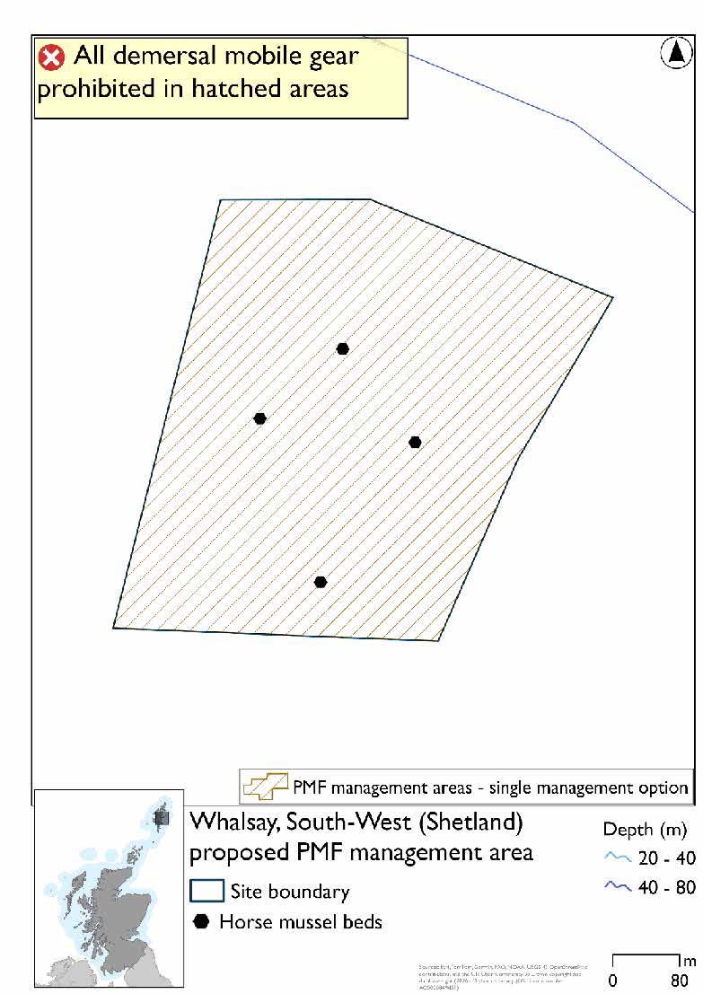
24.8 Whalsay, South-West (Shetland)
24.8.1 Description and background
Whalsay, South-West (Shetland) proposed PMF management area covers a small patch of waters southwest of Symbister on Whalsay. This area has been selected to protect:
- Horse mussel beds
24.8.2 Fisheries management measures proposed
PMF management areas will be closed to demersal trawls and seines, beam trawls, mechanical dredges, and hydraulic dredges. This is because the features present in these areas are sensitive to these gear types.
24.8.3 Options under consideration
A single management option has been developed for this PMF management area. Only one option was identified due to one of, or combination of, evidence (fishing activity or PMF related), boundary setting principles and compliance considerations.
The boundary was drawn around known horse mussel bed records. No additional fishing data were provided within the proposed PMF management area.
24.8.4 Other fisheries management measures currently applying to this area
There are already management measures in place. An effort has been made to identify existing measures which affect each individual site or area, however the list may not be exhaustive. These measures are outlined below, and the proposals for further management being consulted on now are in addition to these existing measures:
- Fishing for sandeel is prohibited within the Scottish zone, which is defined as the sea adjacent to Scotland up to the 200 nautical miles limit
24.9 Wadbister Voe (Shetland)
24.9.1 Description and background*
Wadbister Voe (Shetland) proposed PMF management area covers the entirety of Wadbister Voe on the Shetland mainland. This area has been selected to protect:
- Maerl beds
*This proposed PMF management area overlaps with the East Mainland Coast, Shetland SPA.
24.9.2 Fisheries management measures proposed
PMF management areas will be closed to demersal trawls and seines, beam trawls, mechanical dredges, and hydraulic dredges. This is because the features present in these areas are sensitive to these gear types.
This PMF management area overlaps with management measures being consulted on for East Mainland Coast SPA for set nets (including fyke nets) which are not shown in the maps below.
Please check overlapping site map option(s) to see static gear measures.
24.9.3 Options under consideration
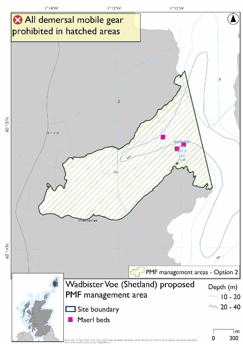
Two options have been developed for this for this PMF management area. Option 1 reflects a smaller footprint that reflects one, or a combination of evidence (fishing activity or PMF related), boundary setting principles and compliance considerations. Option 2 covers a larger footprint that offer improved protection.
There is a maerl bed record included in Option 2 but not included in Option 1 as it is an older record from 1986. No additional fishing data were provided within the proposed PMF management areas.
Option 1: Developed around more recent records, incorporates the SSMO closure, extending slightly to the south-east.
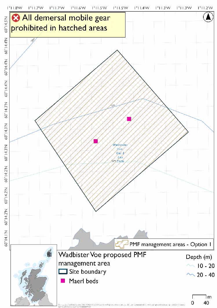
Option 2: This boundary covers a larger footprint that offers improved protection and includes an older record.
24.9.4 Other fisheries management measures currently applying to this area
There are already management measures in place. An effort has been made to identify existing measures which affect each individual site or area, however the list may not be exhaustive. These measures are outlined below, and the proposals for further management being consulted on now are in addition to these existing measures:
- Under the Shetland Regulating Order scallop dredging prohibited in part of the area
- Fishing for sandeel is prohibited within the Scottish zone, which is defined as the sea adjacent to Scotland up to the 200 nautical miles limit
24.10 West Mainland Voes (Shetland)
24.10.1 Description and background
West Mainland Voes (Shetland) proposed PMF management area covers three distinct areas: the waters of Sandsound and Whiteness Voes, as well as an area to the southeast of Fore Holm. This area has been selected to protect:
- Blue mussel beds;
- Horse mussel beds; and
- Seagrass beds
There are also intertidal blue mussel records present but they were not considered as part of this process due to there being no overlaps with bottom-contacting fisheries and intertidal mussel beds.
24.10.2 Fisheries management measures proposed
PMF management areas will be closed to demersal trawls and seines, beam trawls, mechanical dredges, and hydraulic dredges. This is because the features present in these areas are sensitive to these gear types.
24.10.3 Options under consideration
A single management option has been developed for this PMF management area. Only one option was identified due to one of, or combination of, evidence (fishing activity or PMF related), boundary setting principles and compliance considerations.
This covers three discrete locations with some overlaps with current SSMO closures. Amendments were made based on stakeholder feedback and NatureScot advice from what was a bigger area in 2018. No additional fishing data were provided within the proposed PMF management area.
We are aware there are additional horse mussel records outside the area by the Fore Holm area but these were not in GeMS when the areas were drawn. There are also the three horse mussel bed records at Stromness Voe but these are older records (1986, 1987 and 1974) and were not included.
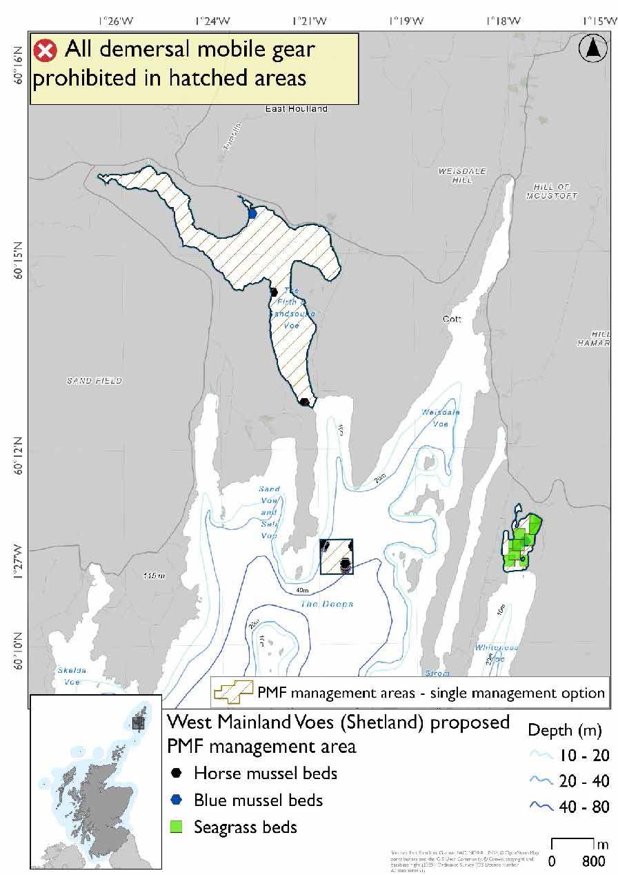
*There are blue mussel bed records obscured by the cluster of seagrass bed records in Whiteness Voe
24.10.4 Other fisheries management measures currently applying to this area
There are already management measures in place. An effort has been made to identify existing measures which affect each individual site or area, however the list may not be exhaustive. These measures are outlined below, and the proposals for further management being consulted on now are in addition to these existing measures:
- Under the Shetland Regulating Order scallop dredging prohibited in part of the area
- Fishing for sandeel is prohibited within the Scottish zone, which is defined as the sea adjacent to Scotland up to the 200 nautical miles limit
24.11 West Voe, East Burra (Shetland)
24.11.1 Description and background
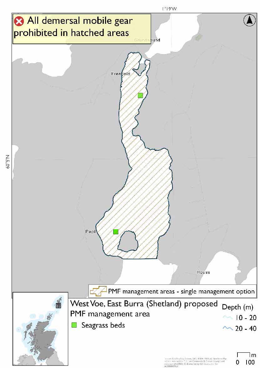
West Voe, East Burra (Shetland) proposed PMF management area covers the waters of West Voe on East Burra as far south as Papil and Houss. This area has been selected to protect:
- Seagrass beds
24.11.2 Fisheries management measures proposed
PMF management areas will be closed to demersal trawls and seines, beam trawls, mechanical dredges, and hydraulic dredges. This is because the features present in these areas are sensitive to these gear types.
24.11.3 Options under consideration
A single management option has been developed for this PMF management area. Only one option was identified due to one of, or combination of, evidence (fishing activity or PMF related), boundary setting principles and compliance considerations.
This area incorporates two SSMO closures which cover the seagrass bed records. No additional fishing data were provided within the proposed PMF management area.
24.11.4 Other fisheries management measures currently applying to this area
There are already management measures in place. An effort has been made to identify existing measures which affect each individual site or area, however the list may not be exhaustive. These measures are outlined below, and the proposals for further management being consulted on now are in addition to these existing measures:
- Under the Shetland Regulating Order scallop dredging prohibited in part of the area
- Fishing for sandeel is prohibited within the Scottish zone, which is defined as the sea adjacent to Scotland up to the 200 nautical miles limit
Contact
Email: marine_biodiversity@gov.scot