
Fisheries Management Measures within Scottish Inshore Marine Protected Areas (MPAs) and Proposed Priority Marine Feature (PMF) Management Areas - Site and Area Proposal Document
This document describes the process, justification and evidence used to develop site and area specific fisheries management measures. It outlines key information for each site and area including their features, and risks of potential pressures.

20. Proposed PMF management areas in the Clyde marine region
20.1 Ardlamont Point (Cowal) proposed PMF management area
20.1.1 Description and background
Ardlamont Point (Cowal) proposed PMF management area covers the waters on the southern edge of Ardlamont Point on the Cowal peninsula. This area has been selected to protect:
- Maerl beds; and
- Maerl or coarse shell gravel with burrowing sea cucumbers
20.1.2 Fisheries management measures proposed
PMF management areas will be closed to demersal trawls and seines, beam trawls, mechanical dredges, and hydraulic dredges. This is because the features present in these areas are sensitive to these gear types.
20.1.3 Options under consideration
Two options have been developed for this for this PMF management area. Option 1 reflects a smaller footprint that reflects one, or a combination of evidence (fishing activity or PMF related), boundary setting principles and compliance considerations. Option 2 covers a larger footprint that offers improved protection.
Option 1: This boundary covers a smaller footprint more closely following depths suitable for maerl beds and accommodating additional fishing activity data where possible.
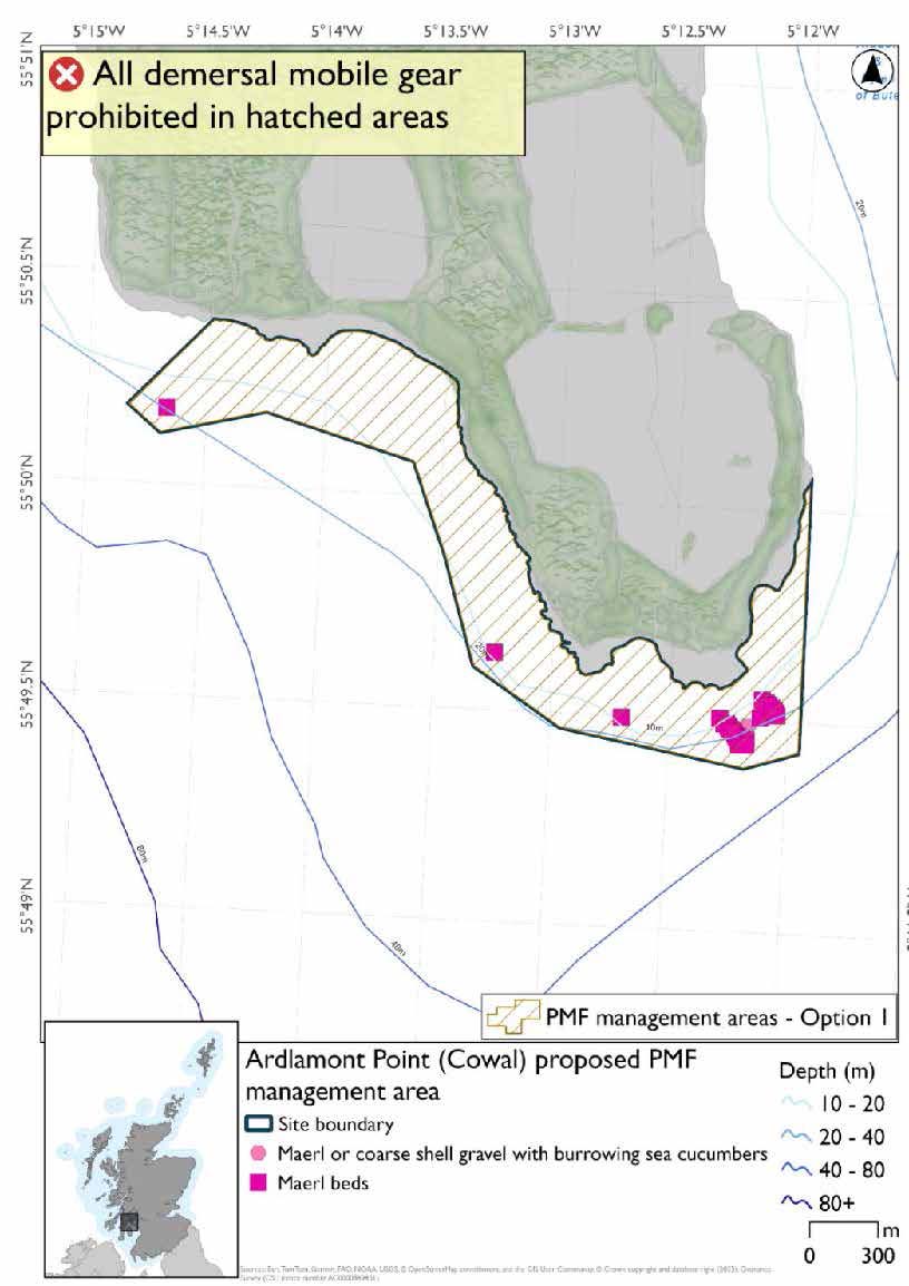
*The maerl or coarse shell gravel with burrowing sea cucumbers record is amongst the large cluster of maerl bed records.
Option 2: This boundary covers a larger footprint that offers improved protection.
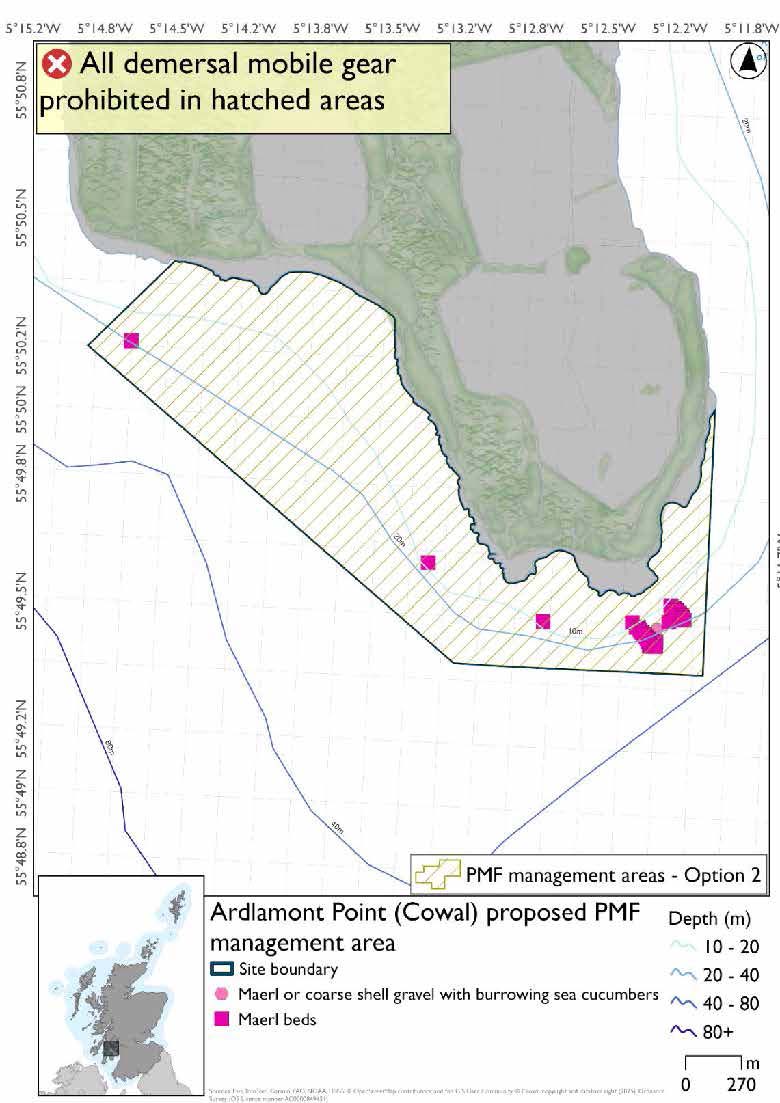
*The maerl or coarse shell gravel with burrowing sea cucumbers record is amongst the large cluster of maerl bed records.
20.1.4 Other fisheries management measures currently applying to this area
There are already management measures in place. An effort has been made to identify existing measures which affect each individual site or area, however the list may not be exhaustive. These measures are outlined below, and the proposals for further management being consulted on now are in addition to these existing measures:
- Fishing for sea fish with mobile or active gear prohibited from midnight on Friday until midnight on Sunday
- Otherwise than in accordance with a written permission granted by the King's harbour master, no person shall dredge in the dockyard port with drags, hooks, nets or other apparatus
- Fishing for sandeel is prohibited within the Scottish zone, which is defined as the sea adjacent to Scotland up to the 200 nautical miles limit
20.2 Gourock (Inverclyde) proposed PMF management area
20.2.1 Description and background
Gourock (Inverclyde) proposed PMF management area covers a discrete area immediately off the coast of Gourock. This area has been selected to protect:
- Horse mussel beds
20.2.2 Fisheries management measures proposed
PMF management areas will be closed to demersal trawls and seines, beam trawls, mechanical dredges, and hydraulic dredges. This is because the features present in these areas are sensitive to these gear types.
20.2.3 Options under consideration
Two options have been developed for this for this PMF management area. Option 1 reflects a smaller footprint that reflects one, or a combination of evidence (fishing activity or PMF related), boundary setting principles and compliance considerations. Option 2 covers a larger footprint that offers improved protection.
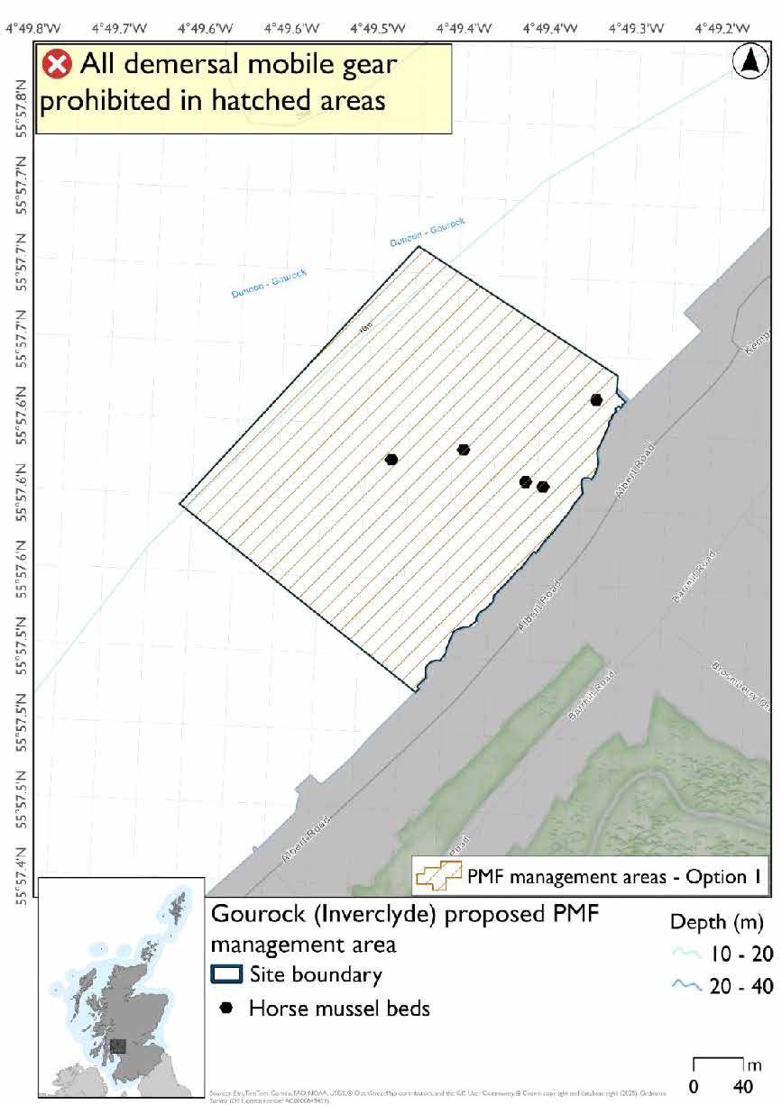
Option 1: Smaller footprint to accommodate additional fishing data provided around the edges of the area, whilst giving sufficient buffers for the features.
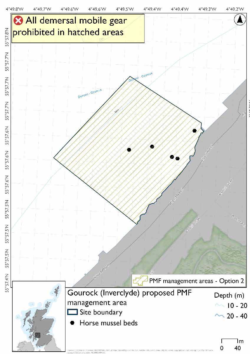
Option 2: This boundary covers a larger footprint that offers improved protection.
20.2.4 Other fisheries management measures currently applying to this area
There are already management measures in place. An effort has been made to identify existing measures which affect each individual site or area, however the list may not be exhaustive. These measures are outlined below, and the proposals for further management being consulted on now are in addition to these existing measures:
- Fishing for sea fish with mobile or active gear prohibited from midnight on Friday until midnight on Sunday
- Otherwise than in accordance with a written permission granted by the King's harbour master, no person shall dredge in the dockyard port with drags, hooks, nets or other apparatus
- Fishing for sandeel is prohibited within the Scottish zone, which is defined as the sea adjacent to Scotland up to the 200 nautical miles limit
20.3 Inchmarnock (Bute)
20.3.1 Description and background
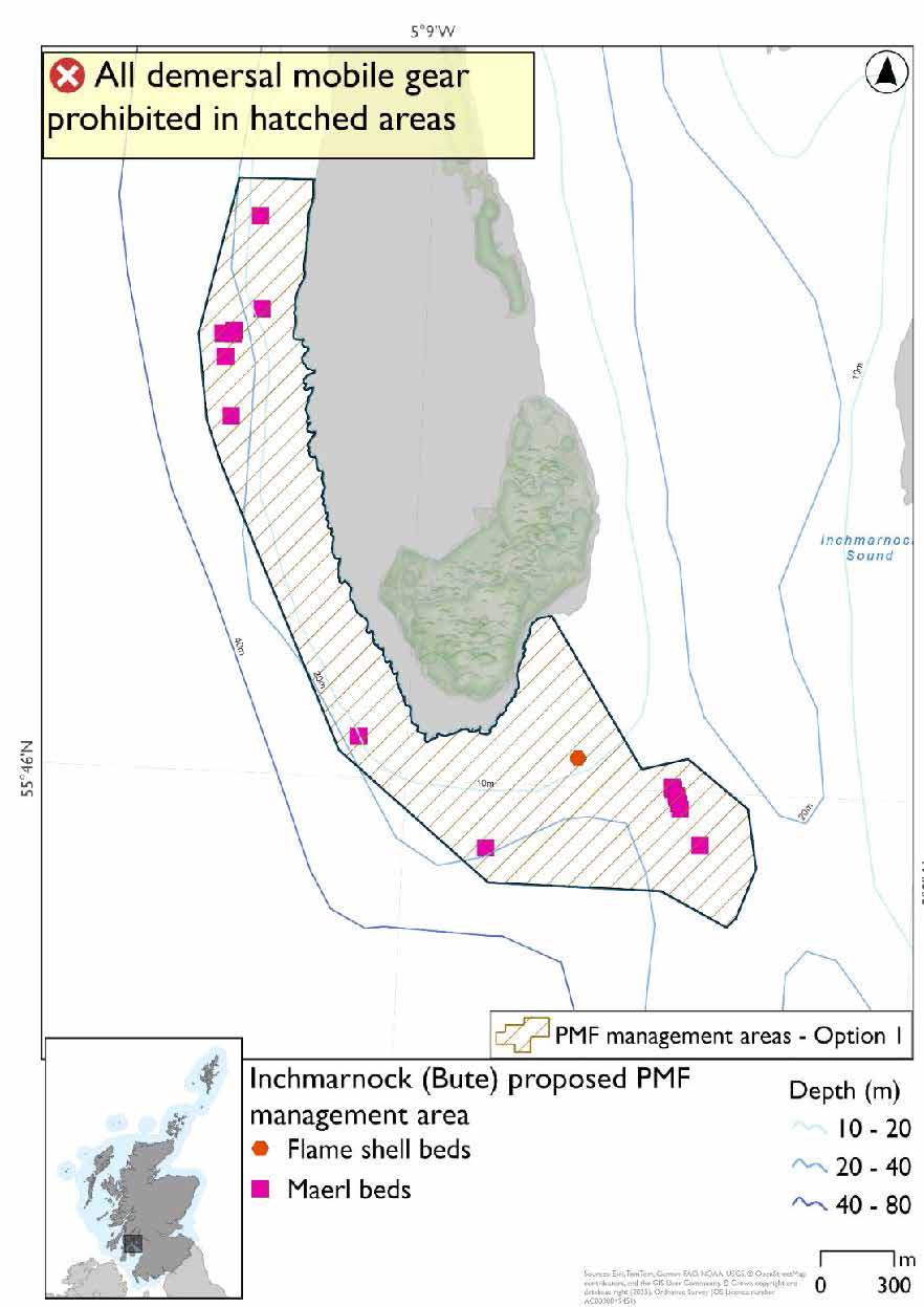
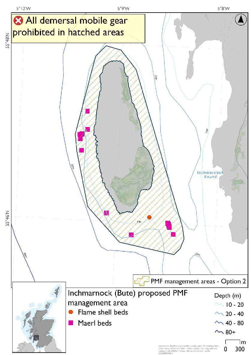
Inchmarnock proposed PMF management area surrounds the island of Inchmarnock near Bute. This area has been selected to protect:
- Maerl beds
There are also flame shell bed records present, but they were not a focus for area selection as further work is needed to confirm its status.
20.3.2 Fisheries management measures proposed
PMF management areas will be closed to demersal trawls and seines, beam trawls, mechanical dredges, and hydraulic dredges. This is because the features present in these areas are sensitive to these gear types.
20.3.3 Options under consideration
Two options have been developed for this for this PMF management area. Option 1 reflects a smaller footprint that reflects one, or a combination of evidence (fishing activity or PMF related), boundary setting principles and compliance considerations. Option 2 covers a larger footprint that offers improved protection.
Option 1: This boundary covers a smaller footprint more closely following extent of known PMFs and depths suitable for maerl beds, and accommodating fishing data provided whilst protecting the PMF records.
Option 2: This boundary covers a larger footprint that offers improved protection.
20.3.4 Other fisheries management measures currently applying to this area
There are already management measures in place. An effort has been made to identify existing measures which affect each individual site or area, however the list may not be exhaustive. These measures are outlined below, and the proposals for further management being consulted on now are in addition to these existing measures:
- Fishing for sea fish with mobile or active gear prohibited from midnight on Friday until midnight on Sunday
- Otherwise than in accordance with a written permission granted by the King's harbour master, no person shall dredge in the dockyard port with drags, hooks, nets or other apparatus
- Fishing for sandeel is prohibited within the Scottish zone, which is defined as the sea adjacent to Scotland up to the 200 nautical miles limit
20.4 Kyles of Bute proposed PMF management area
20.4.1 Description and background
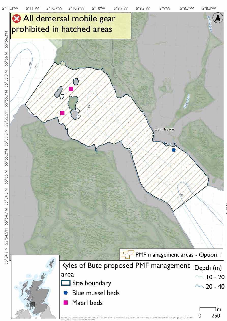
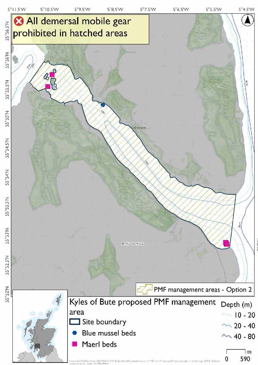
Kyles of Bute proposed PMF management area covers the Eastern Kyle of Bute, from Fearnoch to Glaic. This area has been selected to protect:
- Maerl beds
There are also intertidal blue mussel records present, but they were not considered part of this process due to there being no overlaps with bottom-contacting fisheries and intertidal mussel beds.
20.4.2 Fisheries management measures proposed
PMF management areas will be closed to demersal trawls and seines, beam trawls, mechanical dredges, and hydraulic dredges. This is because the features present in these areas are sensitive to these gear types.
20.4.3 Options under consideration
Two options have been developed for this for this PMF management area. Option 1 reflects a smaller footprint that reflects one, or a combination of evidence (fishing activity or PMF related), boundary setting principles and compliance considerations. Option 2 covers a larger footprint that offers improved protection.
Option 1: This boundary covers a smaller footprint, excluding the very degraded maerl bed records in the southeast and the deeper muddy and mixed sediment habitats in the central channel and accommodates additional fishing data that was provided whilst protecting the PMF records.
Option 2: This boundary covers a larger footprint and includes very degraded maerl bed records in the southeast.
20.4.4 Other fisheries management measures currently applying to this area
There are already management measures in place. An effort has been made to identify existing measures which affect each individual site or area, however the list may not be exhaustive. These measures are outlined below, and the proposals for further management being consulted on now are in addition to these existing measures:
- Fishing for sea fish with mobile or active gear prohibited from midnight on Friday until midnight on Sunday
- Otherwise than in accordance with a written permission granted by the King's harbour master, no person shall dredge in the dockyard port with drags, hooks, nets or other apparatus
- Fishing for sandeel is prohibited within the Scottish zone, which is defined as the sea adjacent to Scotland up to the 200 nautical miles limit
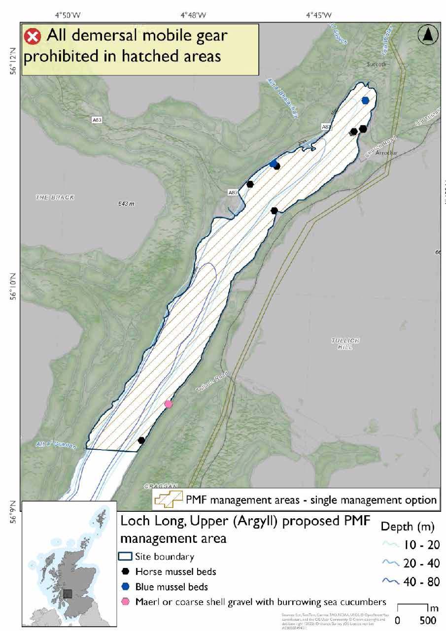
20.5 Loch Long, Upper (Argyll) proposed PMF management area
20.5.1 Description and background
Loch Long, Upper (Argyll) proposed PMF management area covers the waters of Loch Long north of Craggan. This area has been selected to protect:
- Blue mussel beds;
- Horse mussel beds; and
- Maerl or coarse shell gravel with burrowing sea cucumbers.
20.5.2 Fisheries management measures proposed
PMF management areas will be closed to demersal trawls and seines, beam trawls, mechanical dredges, and hydraulic dredges. This is because the features present in these areas are sensitive to these gear types.
20.5.3 Options under consideration
A single management option has been developed for this PMF management area. Only one option was identified due to one of, or combination of, evidence (fishing activity or PMF related), boundary setting principles and compliance considerations.
No additional fishing data were provided within the proposed PMF management area.
20.5.4 Other fisheries management measures currently applying to this area
There are already management measures in place. An effort has been made to identify existing measures which affect each individual site or area, however the list may not be exhaustive. These measures are outlined below, and the proposals for further management being consulted on now are in addition to these existing measures:
- Fishing for sea fish with mobile or active gear prohibited from midnight on Friday until midnight on Sunday
- Otherwise than in accordance with a written permission granted by the King's harbour master, no person shall dredge in the dockyard port with drags, hooks, nets or other apparatus.
- Fishing for any species of sea fish (except herring, mackerel and sprats) from a fishing boat with an overall length not greater than 21.34 metres
- Fishing for sandeel is prohibited within the Scottish zone, which is defined as the sea adjacent to Scotland up to the 200 nautical miles limit
20.6 Merkland (Arran) proposed PMF management area
20.6.1 Description and background
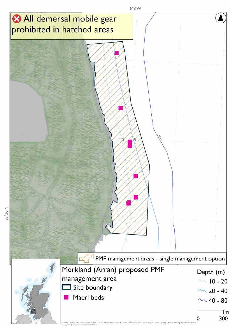
Merkland (Arran) proposed PMF management area covers the waters immediately off a stretch of the northeast coast of Arran between Corrie and Brodick. This area has been selected to protect:
- Maerl beds
20.6.2 Fisheries management measures proposed
PMF management areas will be closed to demersal trawls and seines, beam trawls, mechanical dredges, and hydraulic dredges. This is because the features present in these areas are sensitive to these gear types.
20.6.3 Options under consideration
A single management option has been developed for this PMF management area. Only one option was identified due to one of, or combination of, evidence (fishing activity or PMF related), boundary setting principles and compliance considerations.
The area was adjusted to incorporate a suitable buffer around the records but still accommodating additional fishing data that was provided.
20.6.4 Other fisheries management measures currently applying to this area
There are already management measures in place. An effort has been made to identify existing measures which affect each individual site or area, however the list may not be exhaustive. These measures are outlined below, and the proposals for further management being consulted on now are in addition to these existing measures:
- Fishing for sea fish with mobile or active gear prohibited from midnight on Friday until midnight on Sunday
- Otherwise than in accordance with a written permission granted by the King's harbour master, no person shall dredge in the dockyard port with drags, hooks, nets or other apparatus
- Fishing for sandeel is prohibited within the Scottish zone, which is defined as the sea adjacent to Scotland up to the 200 nautical miles limit
20.7 Sannox (Arran) proposed PMF management area
20.7.1 Description and background
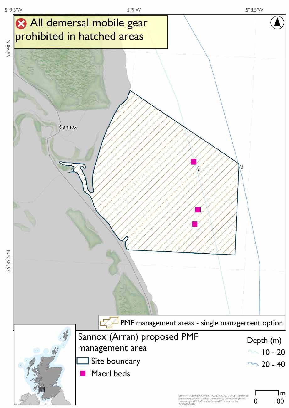
Sannox (Arran) proposed PMF management area protects a small inlet at Sannox and the waters immediately off the adjacent coast. This area has been selected to protect:
- Maerl beds
20.7.2 Fisheries management measures proposed
PMF management areas will be closed to demersal trawls and seines, beam trawls, mechanical dredges, and hydraulic dredges. This is because the features present in these areas are sensitive to these gear types.
20.7.3 Options under consideration
A single management option has been developed for this PMF management area. Only one option was identified due to one of, or combination of, evidence (fishing activity or PMF related), boundary setting principles and compliance considerations.
The boundary was reduced to where maerl bed records are located with sufficient buffer. No additional fishing data were provided within the proposed management area.
20.7.4 Other fisheries management measures currently applying to this area
There are already management measures in place. An effort has been made to identify existing measures which affect each individual site or area, however the list may not be exhaustive. These measures are outlined below, and the proposals for further management being consulted on now are in addition to these existing measures:
- Fishing for sea fish with mobile or active gear prohibited from midnight on Friday until midnight on Sunday
- Otherwise than in accordance with a written permission granted by the King's harbour master, no person shall dredge in the dockyard port with drags, hooks, nets or other apparatus
- Fishing for sandeel is prohibited within the Scottish zone, which is defined as the sea adjacent to Scotland up to the 200 nautical miles limit
20.8 Skipness Point (Kintyre) proposed PMF management area
20.8.1 Description and background
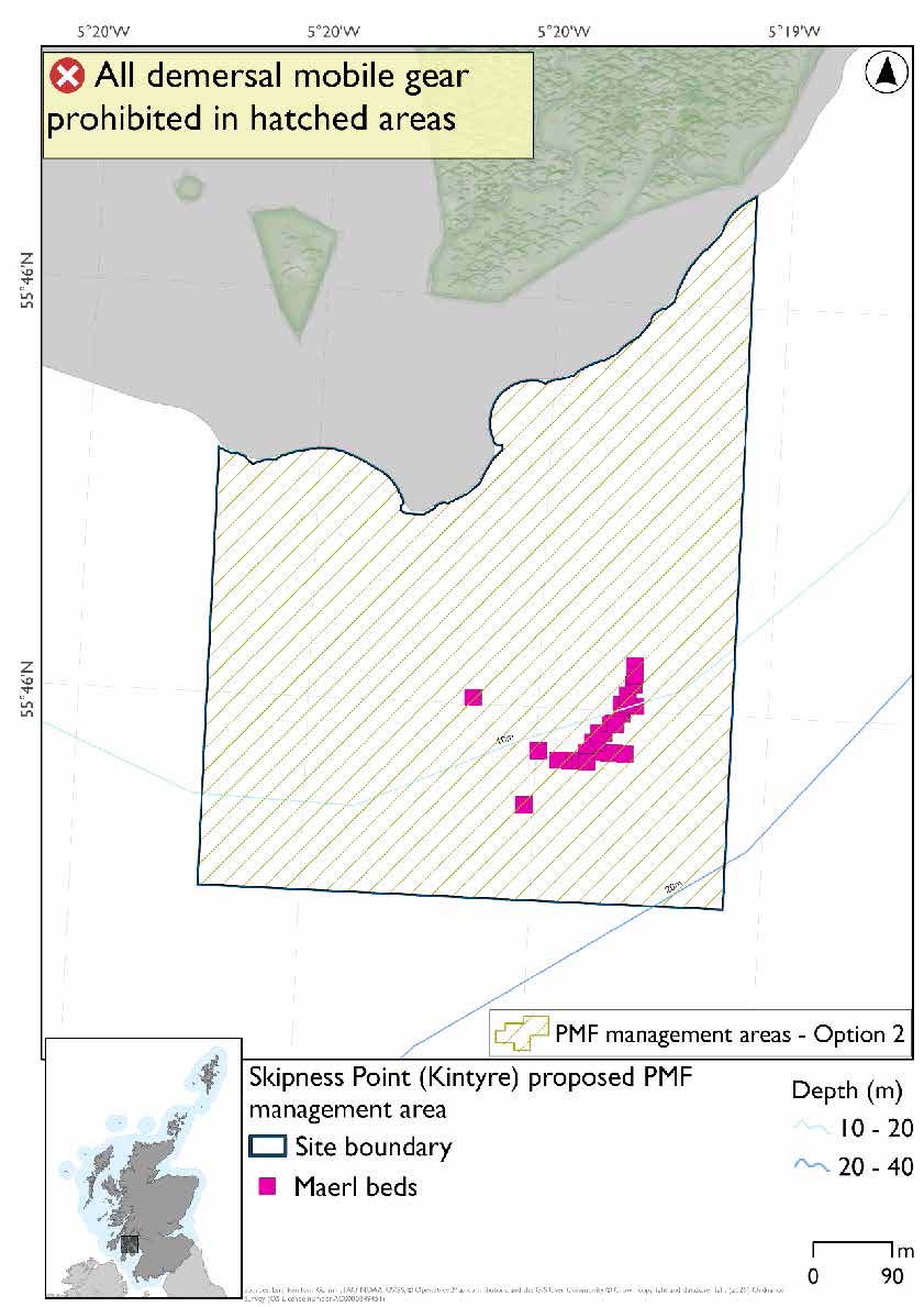
Skipness Point (Kintyre) proposed PMF management area covers a 600m long area stretching no more than 800m from the shore to the east of Skipness in Kintyre. This area has been selected to protect:
- Maerl beds
20.8.2 Fisheries management measures proposed
PMF management areas will be closed to demersal trawls and seines, beam trawls, mechanical dredges, and hydraulic dredges. This is because the features present in these areas are sensitive to these gear types.
20.8.3 Options under consideration
Two options have been developed for this for this PMF management area. Option 1 reflects a smaller footprint that reflects one, or a combination of evidence (fishing activity or PMF related), boundary setting principles and compliance considerations. Option 2 covers a larger footprint that offers improved protection.
Option 1: This boundary covers a smaller footprint accommodating additional fishing data provided with suitable buffer in place for the maerl beds.
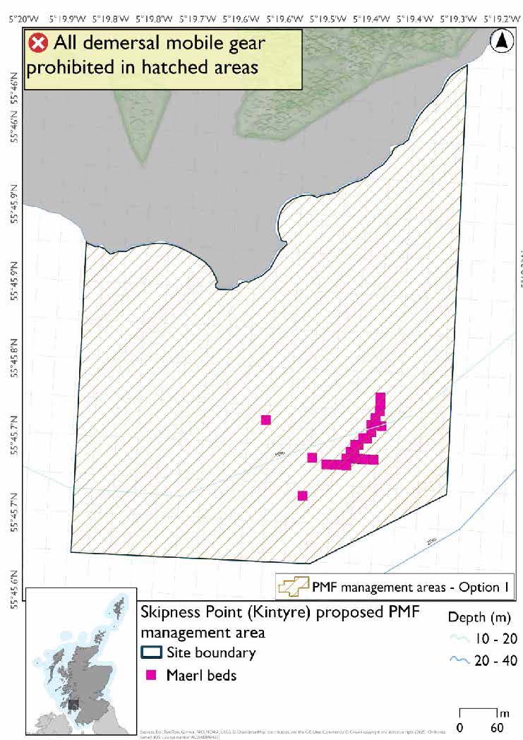
Option 2: This boundary covers a larger footprint that offers improved protection.
20.8.4 Other fisheries management measures currently applying to this area
There are already management measures in place. An effort has been made to identify existing measures which affect each individual site or area, however the list may not be exhaustive. These measures are outlined below, and the proposals for further management being consulted on now are in addition to these existing measures:
- Fishing for sea fish with mobile or active gear prohibited from midnight on Friday until midnight on Sunday
- Otherwise than in accordance with a written permission granted by the King's harbour master, no person shall dredge in the dockyard port with drags, hooks, nets or other apparatus
- Fishing for sandeel is prohibited within the Scottish zone, which is defined as the sea adjacent to Scotland up to the 200 nautical miles limit
20.9 Scalpsay Bay, Gallachan Bay, and Stravannan Bay (Bute) proposed PMF management area
20.9.1 Description and background
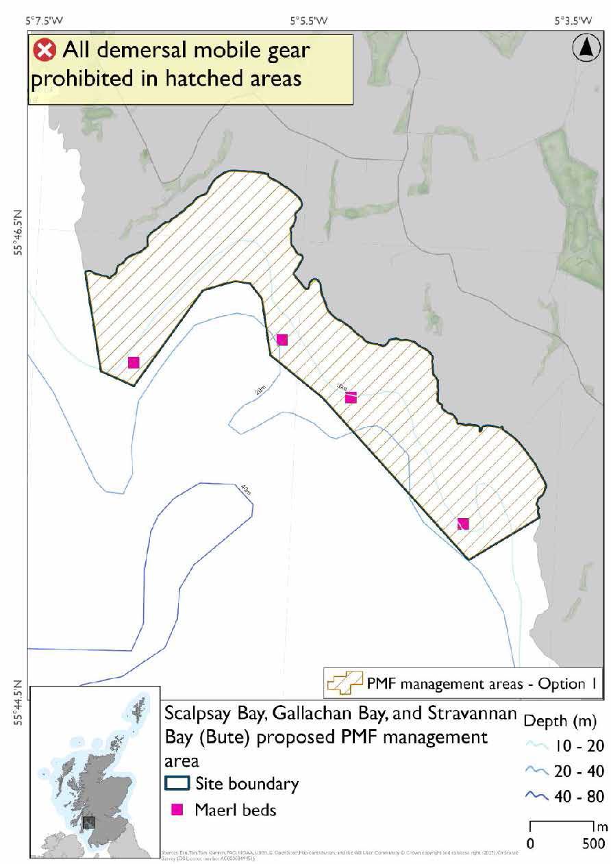
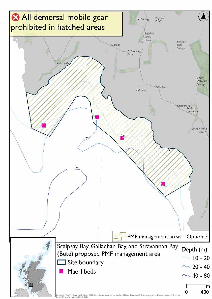
Scalpsay Bay, Gallachan Bay, and Stravannan Bay (Bute) proposed PMF management area covers a continuous area of the southwestern coast of Bute containing the three named bays. This area has been selected to protect:
- Maerl beds
20.9.2 Fisheries management measures proposed
PMF management areas will be closed to demersal trawls and seines, beam trawls, mechanical dredges, and hydraulic dredges. This is because the features present in these areas are sensitive to these gear types.
20.9.3 Options under consideration
Two options have been developed for this for this PMF management area. Option 1 reflects a smaller footprint that reflects one, or a combination of evidence (fishing activity or PMF related), boundary setting principles and compliance considerations. Option 2 covers a larger footprint that offers improved protection.
Option 1: This boundary covers a smaller footprint. This reflects more closely the depths suitable for maerl beds in the north of the area and accommodates additional fishing data provided with suitable buffers around maerl bed records.
Option 2: This boundary covers a larger footprint that offers improved protection around the most westerly maerl bed record.
20.9.4 Other fisheries management measures currently applying to this area
There are already management measures in place. An effort has been made to identify existing measures which affect each individual site or area, however the list may not be exhaustive. These measures are outlined below, and the proposals for further management being consulted on now are in addition to these existing measures:
- Fishing for sea fish with mobile or active gear prohibited from midnight on Friday until midnight on Sunday
- Otherwise than in accordance with a written permission granted by the King's harbour master, no person shall dredge in the dockyard port with drags, hooks, nets or other apparatus
- Fishing for sandeel is prohibited within the Scottish zone, which is defined as the sea adjacent to Scotland up to the 200 nautical miles limit
Contact
Email: marine_biodiversity@gov.scot