
Fisheries Management Measures within Scottish Inshore Marine Protected Areas (MPAs) and Proposed Priority Marine Feature (PMF) Management Areas - Site and Area Proposal Document
This document describes the process, justification and evidence used to develop site and area specific fisheries management measures. It outlines key information for each site and area including their features, and risks of potential pressures.

7. Sites in the Argyll marine region
7.1 Sea of the Hebrides NCMPA
7.1.1 Description and background
The Sea of the Hebrides NCMPA, is located on Scotland’s west coast
Cool, nutrient-rich water mixes with shallow warmer water within the site generating an area of high productivity known as a front. Fronts concentrate nutrients and plankton to create a feeding ground that attracts predators of all shapes and sizes. Basking sharks are the second largest fish in the world, growing up to 10 m long. While similar in length to a basking shark, and weighing up to nine tonnes, minke whales are the smallest members of the baleen whale family found in UK waters. In addition to these dynamic surface waters, the surrounding seabed contributes to the area’s high productivity. Here, calcium‑rich sediments and shell‑derived materials accumulate over time, creating patches of carbonate‑rich habitat that support diverse benthic life such as mearl beds and horse mussel beds. These stable seabed areas provide feeding and resting grounds for invertebrates and small fish, which in turn help sustain the wider food web that attracts large marine predators to the Sea of the Hebrides NCMPA.
Further information, including Conservation and Management Advice (CMA) can be found on Sitelink.
Further information on MPAs, the wider network and protected areas management is available at Scottish Government MPA policy page.
7.1.2 Protected features
The Sea of the Hebrides NCMPA has been designated to protect:
- Basking shark;
- Fronts;
- Minke whale; and
- Marine Geomorphology of the Scottish Shelf Seabed (Inner Hebrides Carbonate Production Area).
Fronts are not discussed further as they are not a protected feature for which fisheries management measures are required.
7.1.3 Conservation Objectives
All of the biodiversity and geodiversity features are in favourable condition at Sea of the Hebrides NCMPA. Therefore the Conservation Objectives for all the protected features within this MPA are to ‘conserve’.
Additional details, including the Conservation Objectives are provided in the Conservation and Management Advice document produced for this NCMPA and can be found on Sitelink.
7.1.4 Pressure from fishing activity
Basking sharks and minke whales are sensitive to entanglement in fishing gear, with entanglement being the leading cause of mortality for minke whales in Scottish waters. Both species are also sensitive to underwater noise from boat activities, which can cause disturbance and also collision risk from vessels with propellers and the bows of vessels. Basking sharks are particularly at risk due to their surface-feeding behaviour and slow maturation, increasing their exposure to gear and vessel strikes.
Marine geomorphology in the Inner Hebrides Carbonate Production Area is sensitive to disturbance from bottom‑contact fishing methods, which can alter seabed type, increase light siltation, cause surface and sub‑surface abrasion, and remove non‑target species. Together, these pressures risk degrading the physical integrity and ecological functioning of the habitat.
Additional details are provided in the Conservation and Management Advice document produced for this NCMPA (section 6) and can be found on Sitelink.
Other resources include:
- The Feature Activity Sensitivity Tool (FeAST) which allows users to investigate the sensitivity of marine features (habitats, species, geology and landforms) in Scotland's seas, to pressures arising from human activities;
- Fisheries Guidance Notes which provide summaries of evidence on the interaction between fishing gears and specific habitats and species.
7.1.5 Fisheries management advice relevant to proposed fisheries management measures
NatureScot provides risk-based advice to help manage activities that may impact protected features and their Conservation Objectives. See section 2.3 for more detail. The CMA document also sets out the full fisheries management advice that has been summarised below for the management measures proposed:
Demersal mobile/active gear
Basking shark – Reduce or limit pressures. The development and adoption of best practice to reduce or limit the risk of incidental catch of basking sharks should be considered.
Inner Hebrides Carbonate Production Area – Reduce or limit pressures. Management measures to reduce or limit demersal mobile/active fishing within the Inner Hebrides Carbonate Production Area are recommended. This should focus on avoiding impacts on the most sensitive carbonate-producing habitats within the area e.g. maerl beds and horse mussel beds.
Measures for demersal mobile gear have not been developed for this site for the Inner Hebrides Carbonate Production Area as these are being addressed through the overlapping proposed PMF management areas. There are 3 areas proposed for the protection of maerl beds and seagrass beds that overlap this site: Ulva and Loch na Keal (Mull), Loch a’Chumhainn (Mull) and Sound of Iona (Mull).
Hydraulic (diver or vessel)
Minke whale – Remove or avoid pressures. The exclusion of hydraulic fishing methods from the habitat of sandeels (as a key prey species of minke whales) within the site is recommended.
Inner Hebrides Carbonate Production Area – Reduce or limit pressures. Management measures to reduce or limit demersal mobile/active fishing within the Inner Hebrides Carbonate Production Area are recommended. This should focus on avoiding impacts on the most sensitive carbonate-producing habitats within the area e.g. maerl beds and horse mussel beds.
Static nets
Exclusion of the use of drift nets and nets set on the seabed (tangle, trammel, gill) from areas used by basking sharks and minke whales between April and October due to the risk of entanglement is recommended.
Inner Hebrides Carbonate Production Area – Reduce or limit pressures. Management measures to reduce or limit the intensity of static gear fishing within the Inner Hebrides Carbonate Production Area should be considered. This should focus on impacts on the most sensitive carbonate-producing habitats within the area e.g. maerl beds and horse mussel beds
Creels
Inner Hebrides Carbonate Production Area – Reduce or limit pressures. Management measures to reduce or limit the intensity of static gear fishing within the Inner Hebrides Carbonate Production Area should be considered. This should focus on impacts on the most sensitive carbonate-producing habitats within the area e.g. maerl beds and horse mussel beds
Specific management measures haven’t been proposed for creels but the further development and adoption of existing best practice to reduce or limit entanglement of basking sharks and minke whales in creel ropes is being explored through the development of the Future Catching Policy under technical measures to reduce bycatch of marine sensitive species, specifically exploring the use of sinking ground lines in creels.
7.1.6 Proposed fisheries management measures for consultation
The descriptions in bold text e.g. Hatching 1, refer to the symbology used in the maps that follow the description of the measures for each option. The proposed management measures for Sea of the Hebrides NCMPA are as follows:
Option 1*
- Set nets (not including fyke nets) prohibited from April till the end of October. (Hatching 1)
- Set nets (not including fyke nets and tangle nets) prohibited from April till the end of October (Hatching 2)
Additional measures from overlapping sites that are included as part of this consultation and overlapping sites that already have measures in place that are for the same fishing gear types:
- Set nets (including fyke nets) prohibited in overlapping areas with Coll and Tiree SPA and West Coast of the Outer Hebrides SPA shallower than 60m, based on maximum dive depth of eider, and the Small Isles NCMPA (includes part of Canna and Sanday SPA) that doesn’t overlap with the Rum SPA (Hatching 3)
- Demersal set nets prohibited from April till the end of October and pelagic set nets prohibited in overlapping areas with Coll and Tiree SPA that are deeper than 60m, based on presence of eider (Fill 4)
- Longlines (until technical measures come into force) and set nets (including fyke nets) prohibited in overlapping areas with Rum SPA (includes part of Canna and Sanday SPA) and Mingulay and Berneray SPA. (Hatching 5)
- Set nets (including fyke nets) and hydraulic dredge already prohibited through overlaps with current designations, East Mingulay SAC, Treshnish Isles SAC and Loch Sunart to the Sound of Jura NCMPA, that already have management measures in place (Fill 6)
- Set nets (not including fyke nets) prohibited in overlapping area with the Inner Hebrides and the Minches SAC (Hatching 7)
- Set nets except tangle nets and fyke nets prohibited in tangle net exemption area that overlaps with the Inner Hebrides and the Minches SAC (Hatching 8)
- Longlines (until technical measures come into force), demersal set nets (including fyke nets) prohibited February till end of August and pelagic set nets prohibited February till mid-October in overlapping portion of Rum SPA deeper than 32.7m but shallower than 177m based on maximum dive depth of guillemot and presence of guillemot and Manx shearwater (Hatching 9)
- Longlines (until technical measures come into force) and set nets (including fyke nets) prohibited February till mid-October in overlapping portion of the Rum SPA shallower than 32.7m, based on mean dive depth (maximum unknown) and presence of Manx shearwater (Fill 10)
- Full site closure to hydraulic dredge
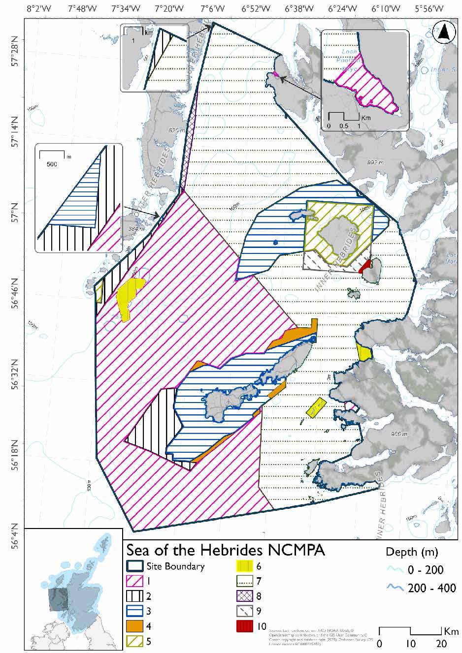
*This site will have other demersal mobile measures that may apply from the overlapping portions with the proposed PMF management areas, Small Isles and Shiant East Bank NCMPAs and Loch nam Madadh SAC that aren’t shown on the map for this option.
- Small Isles NCMPA has zoned measures for demersal trawl, demersal seine net, beam trawl and mechanical dredge
- Loch nam Madadh SAC would prohibit demersal trawl, demersal seine net, beam trawl, mechanical dredge in the overlapping portion.
- The proposed PMF management areas would prohibit all demersal mobile gear from the entire area that overlaps. (see section below for overlapping areas)
Please check the Option 1 or single management overlapping site and area maps to see proposed demersal mobile measures under Option 1.
Option 2*
- Full site closure to set nets (not including fyke nets) and hydraulic dredge
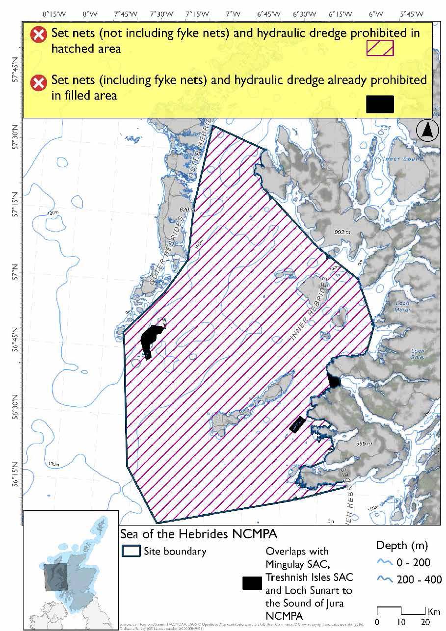
*The measures for Option 2 proposals only come from gear types prohibited in non-overlapping areas. Overlapping restrictions may still apply from overlapping sites or areas dependent on the decisions taken for that site or area. Overlaps showing are from designations that currently have fisheries management measures in place.
Overlapping sites and areas included in this consultation
This NCMPA overlaps with:
- Inner Hebrides and the Minches SAC, Loch nam Madadh SAC and Small Isles NCMPA
- Coll and Tiree, Canna and Sanday, Rum, Mingulay and Berneray and West Coast of the Outer Hebrides SPAs
- South of muck and Bo Fascadale, Muck & Godag, Eigg, South-East, Ulva and Loch na Keal (Mull), Loch a’Chumhainn (Mull), Sound of Iona (Mull), Little Minch, East of Mingulay and Oberon bank proposed PMF management areas.
Rationale for developed measures
The basis for the proposed fisheries management measures for each site has been determined by the management advice for fishing activities provided by NatureScot, which can be found on their website or Sitelink as signposted throughout this document. The Fisheries Assessment for each site assesses the impacts from existing fishing activities on the protected features using the tests from the legislation relevant for the type of MPA being considered. The assessment outlines how the proposed measures address any impacts identified that could hinder the conservation objectives of the MPA.
7.1.7 Other fisheries management measures currently applying to this site
There are already management measures in place. An effort has been made to identify existing measures which affect each individual site or area, however the list may not be exhaustive. These measures are outlined below, and the proposals for further management being consulted on now are in addition to these existing measures:
- The Sandeel (Prohibition of Fishing) (Scotland) Order 2024
- Prohibits fishing for sandeel within the Scottish zone, which is defined as the sea adjacent to Scotland up to the 200 nautical miles limit
North western waters: United Kingdom waters of ICES divisions 5b, 6a,7ahj, 200-600m depth
- Bottom set gillnet, entangling net and trammel net at any position where the charted depth is greater than 200 m in parts of the site
Loch Maddy to Stuley Protected Area
- Hydraulic dredges prohibited all year in part of the site
- Fishing for any species of sea fish except king scallops and queen scallops with a trawl, Danish seine or similar net, purse seine, ring net or dredge between 1st March and 31st October each year (both dates inclusive) in part of the site
- All methods of fishing for king scallops or queen scallops between 1st March and 30th April each year (both dates inclusive) in part of the site
- All methods of fishing for king scallops or queen scallops between 25th August and 31st October each year (both dates inclusive) in part of the site
East Mingulay Protected Area
- Fishing for sea fish with a dredge, beam trawl, demersal seine net, or demersal trawl is prohibited in part of the site
Inner East Mingulay Protected Area
- Fishing for sea fish with any fishing gear is prohibited in part of the site
Loch Sunart Protected Area
- Fishing for sea fish with a dredge, set net, long line, line, beam trawl, demersal trawl, demersal seine net, creel or parlour creel is prohibited in part of the site
- Fishing for horse mussels is prohibited in part of the site
Loch Sunart to the Sound of Jura Protected area
- All fishing activity except for creels prohibited in part of the site – some exception areas allow mechanical dredge or demersal trawl (other than beam trawl) but without the attachment of tickler chains and some of these areas only between 01 October till 31 March each year
Mull Box
- Prohibition, at all times, from fishing with a trawl or dredge (including a suction dredge) in part of the site
Treshnish Isles Protected Area
- Fishing for sea fish with a dredge, beam trawl, demersal trawl, demersal seine net or set net is prohibited in part of the site
Stuley Island to Barra Head and Gurney Point
- Fishing with mobile/active gear prohibited from 1 March to 31 October each year. This includes trawls, Danish seines or similar nets, purse seines, ring nets and dredges (not including suction dredges)
- Fishing for scallops permitted between 01 May and 24th August
- Suction dredging is prohibited all year
ICES VIa between 56 N and 571 30 N outwith Scottish inshore waters (Herring)
- In the part of the ICES zones subject to this TAC that lies between 56˚ N and 57˚ 30' N, with the exception of a six nautical mile belt measured from the baseline of the United Kingdom's territorial sea, this quota can only be used for bycatch covers part of the site
Other conservation measures can be found in section 7 of the CMA.
7.2 Moine Mhor SAC
7.2.1 Description and background
The Mòine Mhór SAC encompasses an extensive raised bog complex and associated habitats in Mid-Argyll. The boundary includes the core peatland area and adjacent transitional zones that link terrestrial and marine environments. To the west, the site extends into the Loch Crinan estuary, incorporating intertidal mudflats, sandflats, and saltmarsh communities. flats, salt meadows, and raised bog on the west coast of Argyll.
Further information, including Conservation and Management Advice (CMA) can be found on Sitelink.
Further information on MPAs, the wider network and protected areas management is available at Scottish Government MPA policy page.
7.2.2 Protected features
The Moine Mhor SAC has been designated to protect:
- Intertidal mudflats and sandflats
7.2.3 Conservation Objectives
The intertidal mudflats and sandflats feature are in favourable condition and therefore the Conservation Objectives seek to maintain this condition.
Additional details, including the Conservation Objectives are provided in the Conservation and Management Advice document produced for this SAC and can be found on Sitelink.
7.2.4 Pressure from fishing activity
Intertidal mudflats and sandflats are sensitive to physical disturbance from fishing-related activities such as bait digging, shellfish collection, and small-scale gear use. These actions disrupt sediment structure, reduce stability, and damage surface biofilms that support nutrient cycling and sediment cohesion. Removal of target and non-target species alters benthic communities, reducing food availability for birds and fish and impacting ecosystem functioning. Repeated disturbance can lead to compaction, erosion, and changes in sediment composition, diminishing habitat quality and resilience. When combined with other pressures, these impacts can accelerate habitat degradation and compromise the Conservation Objectives for these Annex I features.
Additional details are provided in the Conservation and Management Advice document produced for this SAC (section 6) and can be found on Sitelink.
Other resources include:
- The Feature Activity Sensitivity Tool (FeAST) which allows users to investigate the sensitivity of marine features (habitats, species, geology and landforms) in Scotland's seas, to pressures arising from human activities;
- Fisheries Guidance Notes which provide summaries of evidence on the interaction between fishing gears and specific habitats and species.
7.2.5 Fisheries management advice relevant to proposed fisheries management measures
NatureScot provides risk-based advice to help manage activities that may impact protected features and their Conservation Objectives. See section 2.3 for more detail. The CMA document also sets out the full fisheries management advice that has been summarised below for the management measures proposed:
Demersal mobile/active gear
Pressures unlikely to affect the feature however, introduction or spread of non-indigenous species & translocations, physical change, removal of non-target species, siltation rate changes, sub-surface abrasion/penetration and surface abrasion could be pressures on the feature.
Hydraulic (diver or vessel)
Reduce or limit pressures is recommended
7.2.6 Proposed fisheries management measures
The proposed management measure for Moine Mhor SAC is as follows:
Single Proposed Management Option
- Full site closure to mechanical dredge and hydraulic dredge
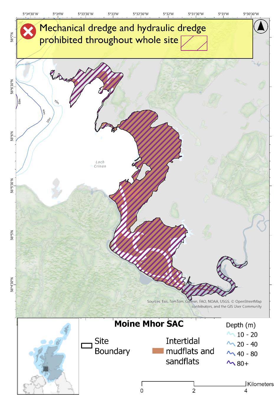
A full site level of protection from the specified gear has been identified as the only suitable option in enabling the achievement of the desired level of protection for the feature in question.
Rationale for developed measures
The basis for the proposed fisheries management measures for each site has been determined by the management advice for fishing activities provided by NatureScot, which can be found on their website or Sitelink as signposted throughout this document. The Fisheries Assessment for each site assesses the impacts from existing fishing activities on the protected features using the tests from the legislation relevant for the type of MPA being considered. The assessment outlines how the proposed measures address any impacts identified that could hinder the conservation objectives of the MPA.
7.2.7 Other fisheries management measures currently applying to this site
There are already management measures in place. An effort has been made to identify existing measures which affect each individual site or area, however the list may not be exhaustive. These measures are outlined below, and the proposals for further management being consulted on now are in addition to these existing measures:
- Fishing for sandeel is prohibited within the Scottish zone, which is defined as the sea adjacent to Scotland up to the 200 nautical miles limit
Other conservation measures can be found in section 7 of the CMA.
7.3 Eileanan agus Sgeiran Lios Mór SAC
7.3.1 Description and background
Eileanan agus Sgeiran Lios Mòr SAC lies off the west coast of Scotland, around the island of Lismore. It comprises five groups of small offshore islands and rocky skerries that provide sheltered, enclosed conditions ideal for harbour seals. These skerries, particularly along their north coasts, including the Creag Isles, areas west of Eilean Dubh, around Eilean nam Meann, Dubh Sgeir in the north-west of Lismore, and Sgeir an Teampuill, have been consistently used for haul‑out by harbour seals for several decades. The surrounding marine habitats support a range of species and resources, including fish, shellfish (particularly juveniles), birds, and marine mammals. The site is designated for its importance in supporting a significant harbour seal population, protecting over 1% of the UK population at the time of designation, and providing key conservation benefits through safeguarding important haul‑out sites and associated habitats.
Further information, including Conservation and Management Advice (CMA) can be found on Sitelink.
Further information on MPAs, the wider network and protected areas management is available at Scottish Government MPA policy page.
7.3.2 Protected features
The Eileanan agus Sgeiran Lios mór SAC has been designated to protect:
- Harbour seal
7.3.3 Conservation Objectives
Harbour seal is in favourable condition at Eileanan agus Sgeiran Lios mór SAC and therefore the Conservation Objectives seek to maintain this condition.
Additional details, including the Conservation Objectives are provided in the Conservation and Management Advice document produced for this SAC and can be found on Sitelink.
7.3.4 Pressure from fishing activity
Fishing activities can exert multiple pressures on harbour seals, particularly through entanglement in fishing gear, which can cause injury or death, especially among younger or inexperienced individuals. Underwater noise from vessels and equipment used in fishing operations can disrupt communication, navigation, and foraging, leading to stress and displacement, especially during sensitive periods like breeding and moulting.
Disturbance from fishing-related activity may alter haul-out behaviour, reduce resting time, and in severe cases, lead to site abandonment. During breeding, such disruptions can interrupt lactation or separate mothers from pups, reducing pup survival.
Additional details are provided in the Conservation and Management Advice document produced for this SAC (section 6) and can be found on Sitelink.
Other resources include:
- The Feature Activity Sensitivity Tool (FeAST) which allows users to investigate the sensitivity of marine features (habitats, species, geology and landforms) in Scotland's seas, to pressures arising from human activities;
- Fisheries Guidance Notes which provide summaries of evidence on the interaction between fishing gears and specific habitats and species.
7.3.5 Fisheries management advice relevant to proposed fisheries management measures
NatureScot provides risk-based advice to help manage activities that may impact protected features and their Conservation Objectives. See section 2.3 for more detail. The CMA document also sets out the full fisheries management advice that has been summarised below for the management measures proposed:
Netting (Bottom-set gill nets including tangle and trammel nets. Drift nets, purse seine, ring-nets and fyke nets.)
Reduce or limit pressures - (entanglement) associated with the use of nets is recommended for seals.
7.3.6 Proposed fisheries management measures
The proposed management measure for Eileanan agus Sgeiran Lios mór SAC is as follows:
Single Proposed Management Option*
- Full site closure to set nets (including fyke nets), pelagic seine and ring nets
- Hydraulic dredge would be prohibited in overlapping areas with the Inner Hebrides and the Minches SAC from proposed measures and is already prohibited in overlapping areas with the Loch Sunart to Sound of Jura NCMPA from management measures already in place
*Set nets (including fyke nets) are also already prohibited in in overlapping areas with the Loch Sunart to Sound of Jura NCMPA from management measures already in place.
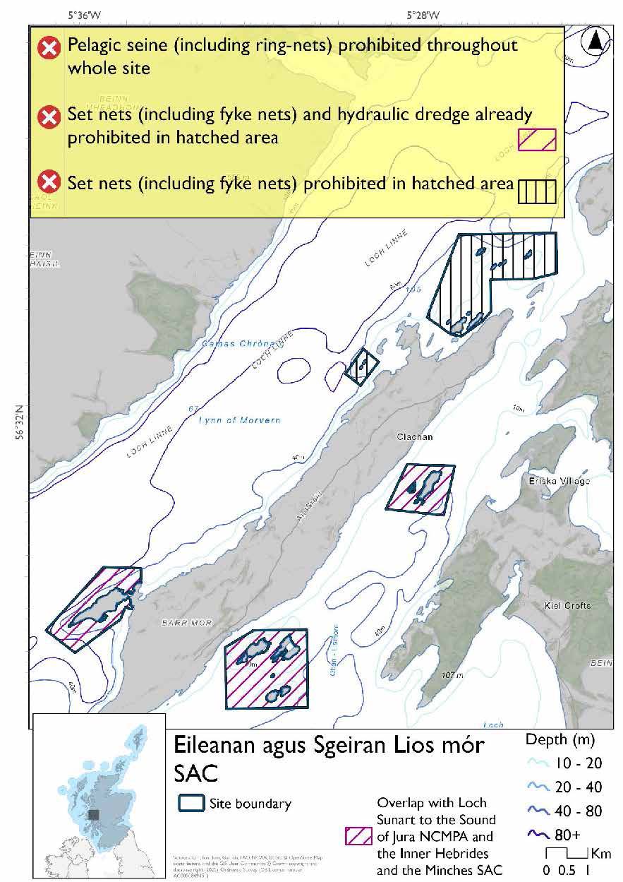
A full site level of protection from the specified gear has been identified as the only suitable option in enabling the achievement of the desired level of protection for the feature in question.
Overlapping site included in this consultation
This SAC overlaps with the Inner Hebrides and the Minches SAC
Rationale for developed measures
The basis for the proposed fisheries management measures for each site has been determined by the management advice for fishing activities provided by NatureScot, which can be found on their website or Sitelink as signposted throughout this document. The Fisheries Assessment for each site assesses the impacts from existing fishing activities on the protected features using the tests from the legislation relevant for the type of MPA being considered. The assessment outlines how the proposed measures address any impacts identified that could hinder the conservation objectives of the MPA.
7.3.7 Other fisheries management measures currently applying to this site
There are already management measures in place. An effort has been made to identify existing measures which affect each individual site or area, however the list may not be exhaustive. These measures are outlined below, and the proposals for further management being consulted on now are in addition to these existing measures:
- Fishing for sandeel is prohibited within the Scottish zone, which is defined as the sea adjacent to Scotland up to the 200 nautical miles limit
- A person must not deploy (by any means) or use any fishing gear. Does not apply to the deployment or use of a demersal trawl (other than a beam trawl) but without the attachment and use of tickler chains in part of the site, all year
- A person must not deploy (by any means) or use any fishing gear in part of the site. (Dredge, trawl, gillnet, suction dredges and hooks), all year
Other conservation measures can be found in section 7 of the CMA.
6.4 South-East Islay Skerries SAC
7.4.1 Description and background
The skerries, islands and rugged coastline of the Inner Hebridean island of Islay hold a nationally important population of the Harbour seal. The south-east coastline areas are extensively used as pupping, moulting and haul-out sites by the seals.
The SAC consists of numerous small, rocky skerries off the south east coast of Islay. This area represents between 1.5% and 2% of the UK population of harbour seals. The marine habitats also support a variety of natural resources including fish, shellfish (including juveniles), mammal and bird species.
Further information, including Conservation and Management Advice (CMA) can be found on Sitelink.
Further information on MPAs, the wider network and protected areas management is available at Scottish Government MPA policy page.
7.4.2 Protected features
South-East Islay Skerries SAC is designated to protect:
- Harbour seal
7.4.3 Conservation Objectives.
Harbour seal is favourable condition South-East Islay Skerries SAC and therefore the Conservation Objectives seek to maintain this condition.
Additional details, including the Conservation Objectives are provided in the Conservation and Management Advice document produced for this SAC and can be found on Sitelink.
7.4.4 Pressure from fishing activity
Fishing activities can exert multiple pressures on harbour seals, particularly through entanglement in fishing gear, which can cause injury or death, especially among younger or inexperienced individuals. Underwater noise from vessels and equipment used in fishing operations can disrupt communication, navigation, and foraging, leading to stress and displacement, especially during sensitive periods like breeding and moulting.
Disturbance from fishing-related activity may alter haul-out behaviour, reduce resting time, and in severe cases, lead to site abandonment. During breeding, such disruptions can interrupt lactation or separate mothers from pups, reducing pup survival.
Additional details are provided in the Conservation and Management Advice document produced for this SAC (section 6) and can be found on Sitelink .
Other resources include:
- The Feature Activity Sensitivity Tool (FeAST) which allows users to investigate the sensitivity of marine features (habitats, species, geology and landforms) in Scotland's seas, to pressures arising from human activities;
- Fisheries Guidance Notes which provide summaries of evidence on the interaction between fishing gears and specific habitats and species.
7.4.5 Fisheries management advice relevant to proposed fisheries management measures
NatureScot provides risk-based advice to help manage activities that may impact protected features and their Conservation Objectives. See section 2.3 for more detail. The CMA document also sets out the full fisheries management advice that has been summarised below for the management measures proposed:
Netting (Bottom-set gill nets including tangle and trammel nets. Drift nets, purse seine, ring-nets and fyke nets.)
Reduce or limit pressures - (entanglement) associated with the use of nets is recommended for seals.
7.4.6 Proposed fisheries management measures
The proposed management measure for South-East Islay Skerries SAC is as follows:
Single Proposed Management Option*
- Full site closure to set nets (including fyke nets), pelagic seines, and ring nets
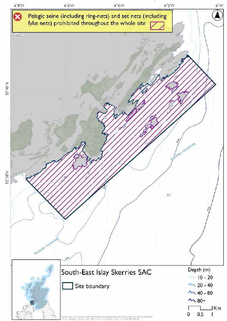
A full site level of protection from the specified gear has been identified as the only suitable option in enabling the achievement of the desired level of protection for the feature in question.
*This site will have other demersal mobile measures that may apply from the overlapping portions with the proposed PMF management area that aren’t shown on the map for this option:
- The proposed PMF management area would prohibit all demersal mobile gear from the entire area that overlaps. (see section below for overlapping area)
Please check the Option 1 or single management overlapping area map to see proposed demersal mobile measures.
Overlapping area included in this consultation
This SAC overlaps with Loch a' Chnuic and Ardilistry (Islay) proposed PMF management area
Rationale for developed measures
The basis for the proposed fisheries management measures for each site has been determined by the management advice for fishing activities provided by NatureScot, which can be found on their website or Sitelink as signposted throughout this document. The Fisheries Assessment for each site assesses the impacts from existing fishing activities on the protected features using the tests from the legislation relevant for the type of MPA being considered. The assessment outlines how the proposed measures address any impacts identified that could hinder the conservation objectives of the MPA.
7.4.7 Other fisheries management measures currently applying to this site
There are already management measures in place. An effort has been made to identify existing measures which affect each individual site or area, however the list may not be exhaustive. These measures are outlined below, and the proposals for further management being consulted on now are in addition to these existing measures:
- Fishing for sandeel is prohibited within the Scottish zone, which is defined as the sea adjacent to Scotland up to the 200 nautical miles limit
Other conservation measures can be found in section 7 of the CMA.
7.5 Coll and Tiree SPA
7.5.1 Description and background
The Coll and Tiree SPA surrounds the adjacent islands of Coll and Tiree off the Argyll coast and is designated to protect important populations of wintering waterfowl, notably great northern diver and eider, along with their supporting habitats.
The site encompasses shallow coastal waters, typically less than 20m deep, characterised by a mix of sand, mud and gravel substrates. These habitats support diverse prey, including fish and invertebrates, providing excellent foraging and roosting conditions, particularly for diving species such as great northern diver.
Further information, including Conservation and Management Advice (CMA) can be found on Sitelink.
Further information on MPAs, the wider network and protected areas management is available at Scottish Government MPA policy page.
7.5.2 Protected features
The Coll and Tiree SPA has been designated to protect:
- Eider; and
- Great northern diver
The protected features of the Coll and Tiree SPA are protected within the SPA throughout the year, irrespective of the season for which they qualified as a protected feature.
7.5.3 Conservation Objectives
The protected features have not been assessed since designation however, corroborative evidence suggests there is no reason to suspect deterioration in condition since site selection giving them a favourable condition. Therefore, the Conservation Objectives for the Coll and Tiree SPA seek to maintain this condition.
Additional details, including the Conservation Objectives are provided in the Conservation and Management Advice document produced for this SPA and can be found on Sitelink .
7.5.4 Pressure from fishing activity
Great northern divers and Eider are both sensitive to entanglement as incidental bycatch, particularly in static fishing gear near the seabed. Divers are also sensitive to collision risks, both above and below water, which may be exacerbated by vessel traffic associated with fishing. Disturbance from fishing vessels can lead to displacement, with great northern divers known to take evasive action at considerable distances. Although their habitat and prey preferences are not well understood, any reduction in prey availability due to fishing impacts on benthic habitats could negatively affect their populations.
Eider are similarly sensitive to entanglement and collision, especially during their flightless moult period when mobility is reduced. They are frequently disturbed by vessel movements and may be displaced from key foraging areas. Eider rely heavily on bivalve prey, such as mussels and cockles, which can be depleted by fishing activities. While they may switch to alternative prey, this ability is limited, and prey loss can lead to reduced body condition and increased mortality.
Additional details are provided in the Conservation and Management Advice document produced for this SPA (section 6) and can be found on Sitelink.
Other resources include:
- The Feature Activity Sensitivity Tool (FeAST) which allows users to investigate the sensitivity of marine features (habitats, species, geology and landforms) in Scotland's seas, to pressures arising from human activities;
- Fisheries Guidance Notes which provide summaries of evidence on the interaction between fishing gears and specific habitats and species.
7.5.5 Fisheries management advice relevant to proposed fisheries management measures
NatureScot provides risk-based advice to help manage activities that may impact protected features and their Conservation Objectives. See section 2.3 for more detail. The CMA document also sets out the full fisheries management advice that has been summarised below for the management measures proposed:
Hydraulic gear
It is recommended to avoid or remove pressures (such as removal of prey species and disturbance of prey-supporting habitat) associated with hydraulic fishing that could damage seabed habitat (in particular, sandeel habitat).
Static gear
It is recommended to remove or avoid pressures (such as entanglement) associated with the use of all set nets. Spatial exclusion of static nets in areas identified as important for great northern divers (as identified from habitat and dive depth preferences) between October and May each year is recommended. Spatial exclusion of static nets in areas identified as important for Eider (as identified from habitat and dive depth preferences) is recommended.
Pelagic gear
Pelagic fishing for herring/sprat may occur within or around the SPA. A principal objective of the management of the fishery should be ensuring that the fishing activity does not prevent or disrupt the availability of prey species for protected features. This means it should be considered as part of a broader ecosystem based approach to management of this fishery.
For the SPAs advice has also been provided on maximum dive depth and seasonality for protected features of each site and can be found in the Fishing Activity Further Advice and Evidence document. Supplementary advice can also be found on NatureScot’s website.
7.5.6 Proposed fisheries management measures
The proposed management measures for Coll and Tiree SPA are as follows.
Option 1
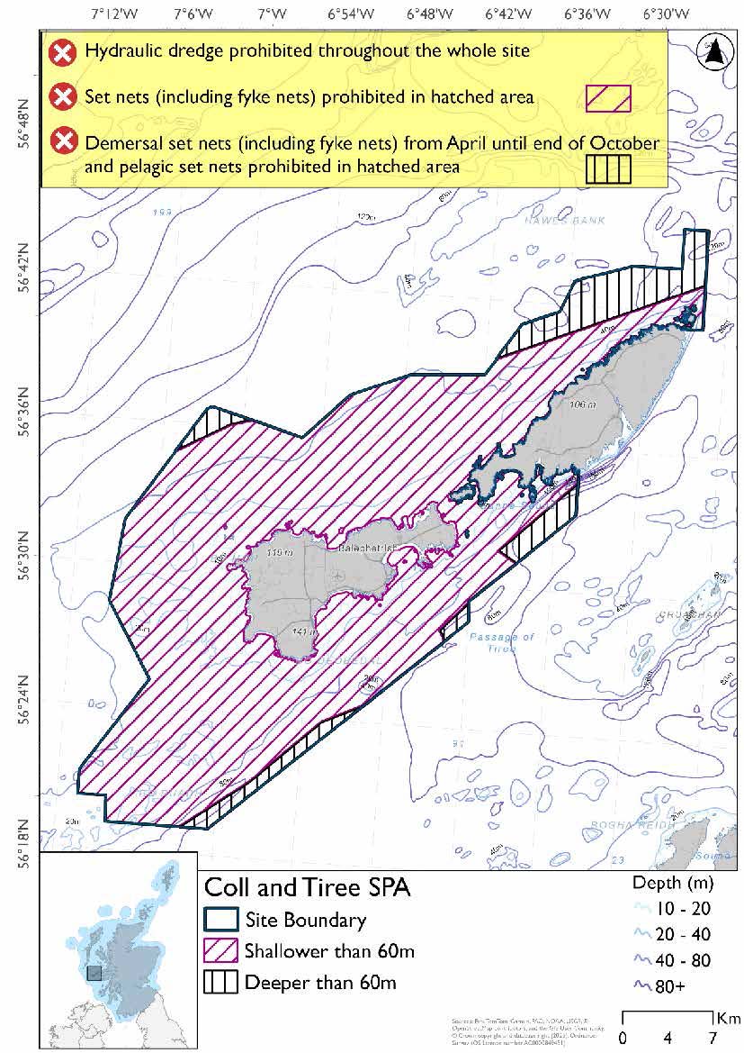
- Set nets (including fyke nets) prohibited in areas down to 60m based on presence and maximum dive depth of eider
- In areas deeper than 60m, demersal set nets prohibited from April till end of October due to overlap with the Sea of the Hebrides NCMPA and pelagic set nets prohibited due to presence of all protected features
- Full site closure to hydraulic dredge
Option 2
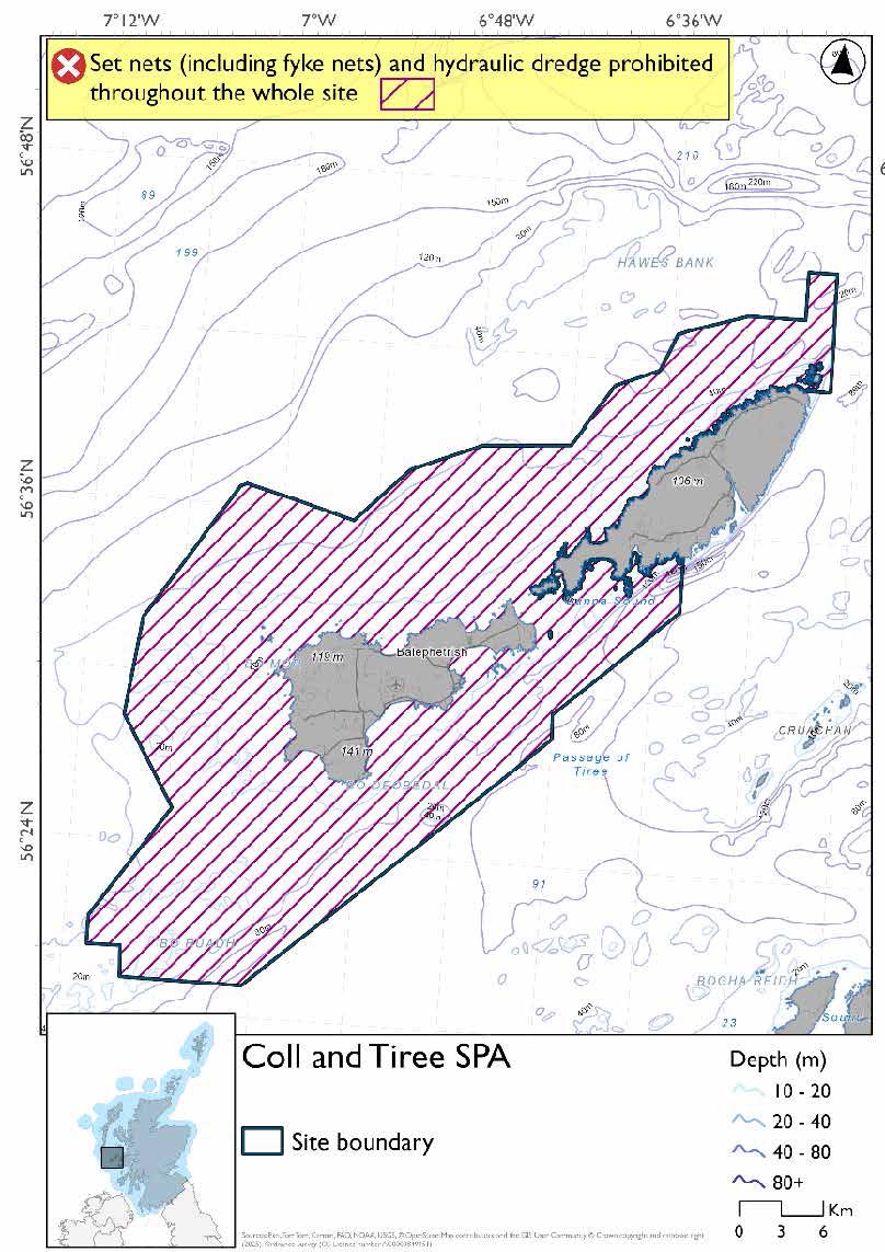
- Full site closure to set nets (including fyke nets) and hydraulic dredge.
Overlapping sites included in this consultation
This SPA overlaps with the Sea of the Hebrides NCMPA and Inner Hebrides and the Minches SAC.
Rationale for developed measures
The basis for the proposed fisheries management measures for each site has been determined by the management advice for fishing activities provided by NatureScot, which can be found on their website or Sitelink as signposted throughout this document. The Fisheries Assessment for each site assesses the impacts from existing fishing activities on the protected features using the tests from the legislation relevant for the type of MPA being considered. The assessment outlines how the proposed measures address any impacts identified that could hinder the conservation objectives of the MPA..
7.5.7 Other fisheries management measures currently applying to this site
There are already management measures in place. An effort has been made to identify existing measures which affect each individual site or area, however the list may not be exhaustive. These measures are outlined below, and the proposals for further management being consulted on now are in addition to these existing measures:
- Fishing for sandeel is prohibited within the Scottish zone, which is defined as the sea adjacent to Scotland up to the 200 nautical miles limit
Other conservation measures can be found in section 7 of the CMA.
7.6 Sound of Gigha SPA
7.6.1 Description and background
The Sound of Gigha SPA lies off the west coast of the Kintyre peninsula in Argyll and Bute and is centred around the island of Gigha. It extends from Machrihanish Bay in the south to the entrance of Loch Caolisport off Knapdale to the North, including West Loch Tarbert.
The area has a complex bathymetry, and also varies greatly in exposure to prevailing winds and Atlantic waves. There are many rocks and skerries as well as small, sheltered bays around Gigha itself, and Gigha Sound is scoured by north-south channels. Offshore, the sediments are a mixture of mud, sand and gravel while the very sheltered waters of West Loch Tarbert overlie soft mud sediment. This complexity in physical conditions provides for a locally diverse range of habitats and associated marine fauna which in turn support notable populations of wintering waterfowl.
For great northern divers and Slavonian grebes, the site offers important wintering habitat and. Eiders and red-breasted mergansers also rely on the area for feeding and shelter during the non-breeding season, particularly in the more sheltered bays and lochs.
Further information, including Conservation and Management Advice (CMA) can be found on Sitelink.
Further information on MPAs, the wider network and protected areas management is available at Scottish Government MPA policy page.
7.6.2 Protected features
The Sound of Gigha SPA has been designated to protect:
- Eider;
- Great northern diver;
- Red-breasted merganser; and
- Slavonian grebe
The protected features of the Sound of Gigha SPA are protected within the SPA throughout the year, irrespective of the season for which they qualified as a protected feature.
7.6.3 Conservation Objectives
The protected features have not been assessed since designation however corroborative evidence suggests there is no reason to suspect deterioration in condition since site selection giving them a favourable condition. Therefore, the Conservation Objectives for the Sound of Gigha SPA seek to maintain this condition.
Additional details, including the Conservation Objectives are provided in the Conservation and Management Advice document produced for this SPA and can be found on Sitelink .
7.6.4 Pressure from fishing activity
Great northern divers, Slavonian grebes, eiders, and red-breasted mergansers are all sensitive to entanglement in fishing gear and incidental bycatch, with varying degrees of vulnerability depending on behaviour and habitat use. All four species exhibit avoidance or disturbance responses to vessel movements, particularly during sensitive periods such as moulting, when flight capability is reduced.
Habitat degradation from fishing gear, especially bottom-contact methods, may reduce prey availability and impact foraging success. This is particularly relevant for eiders, which rely heavily on bivalves like mussels, and for Slavonian grebes, whose foraging may be affected by changes in water clarity. While prey preferences for some species (e.g. great northern divers) are less well understood, the potential for prey depletion due to fishing remains a concern across all species.
Additional details are provided in the Conservation and Management Advice document produced for this SPA (section 6) and can be found on Sitelink.
Other resources include:
- The Feature Activity Sensitivity Tool (FeAST) which allows users to investigate the sensitivity of marine features (habitats, species, geology and landforms) in Scotland's seas, to pressures arising from human activities;
- Fisheries Guidance Notes which provide summaries of evidence on the interaction between fishing gears and specific habitats and species.
7.6.5 Fisheries management advice relevant to proposed fisheries management measures
NatureScot provides risk-based advice to help manage activities that may impact protected features and their Conservation Objectives. See section 2.3 for more detail. The CMA document also sets out the full fisheries management advice that has been summarised below for the management measures proposed:
Hydraulic gear
It is recommended to remove or avoid pressures (removal of prey species and disturbance of prey-supporting habitat) associated with hydraulic fishing that could damage seabed habitat (in particular, sandeel habitat).
Static gear
It is recommended to remove or avoid pressures (such as entanglement) associated with the use of all set nets. Spatial exclusion of static nets in areas identified as being important for the protected species (as identified from habitat and dive depth preferences). For great northern diver and Slavonian grebe, exclusion between mid-September and mid-May each year is recommended.
Pelagic gear
Pelagic fishing for herring/sprat may occur within or around the SPA. A principal objective of the management of the fishery should be ensuring that the fishing activity does not prevent or disrupt the availability of prey species for divers, Slavonian grebe, or red-breasted merganser. This means it should be considered as part of a broader ecosystem based approach to management of this fishery.
For the SPAs advice has also been provided on maximum dive depth and seasonality for protected features of each site and can be found in the Fishing Activity Further Advice and Evidence document. Supplementary advice can also be found on NatureScot’s website.
7.6.6 Proposed fisheries management measures
The proposed management measures for Sound of Gigha SPA are as follows.
Option 1*
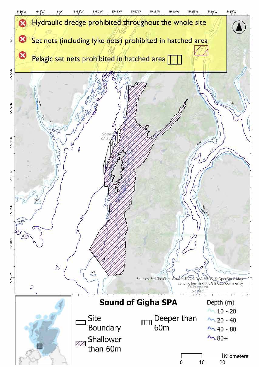
- Set nets (including fyke nets) prohibited in areas down to 60m based on presence and maximum dive depth of eider
- Pelagic set nets prohibited in areas deeper than 60m based on presence of all species
- Full site closure to hydraulic dredges
*This site will have other demersal mobile measures that may apply from the overlapping portions with the proposed PMF management areas that aren’t shown on the map for this option.
- The proposed PMF management areas would prohibit all demersal mobile gear from the entire area that overlaps. (see section below for overlapping areas)
Please check the Option 1 or single management overlapping area maps to see proposed demersal mobile measures under Option 1.
Option 2*
- Full site closure to set nets (including fyke nets) and hydraulic dredges
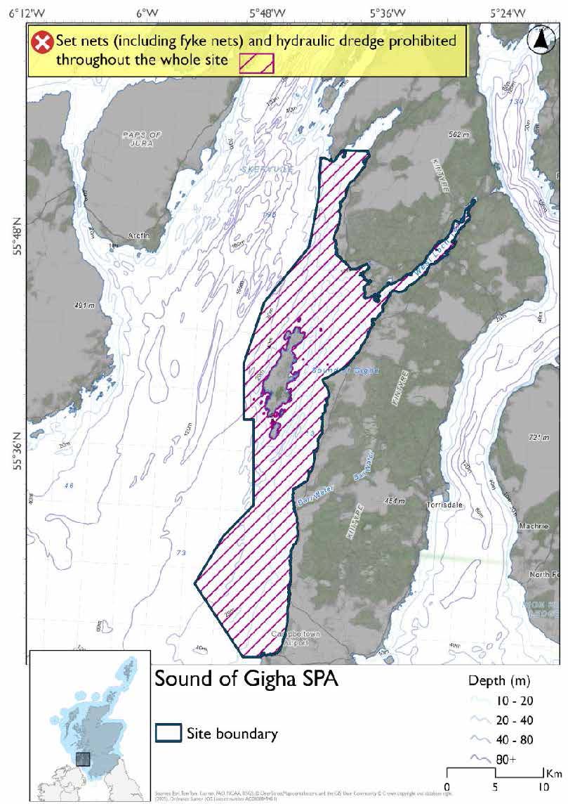
*The measures for Option 2 proposals only come from gear types prohibited in non-overlapping areas. Overlapping restrictions may still apply from overlapping sites or areas dependent on the decisions taken for that site or area.
Overlapping site and areas included in this consultation
This SPA overlaps with the Inner Hebrides and the Minches SAC and West Loch Tarbert (Kintyre), Gigha North-East and Gigha South proposed PMF management areas.
Rationale for developed measures
The basis for the proposed fisheries management measures for each site has been determined by the management advice for fishing activities provided by NatureScot, which can be found on their website or Sitelink as signposted throughout this document. The Fisheries Assessment for each site assesses the impacts from existing fishing activities on the protected features using the tests from the legislation relevant for the type of MPA being considered. The assessment outlines how the proposed measures address any impacts identified that could hinder the conservation objectives of the MPA.
7.6.7 Other fisheries management measures currently applying to this site
There are already management measures in place. An effort has been made to identify existing measures which affect each individual site or area, however the list may not be exhaustive. These measures are outlined below, and the proposals for further management being consulted on now are in addition to these existing measures:
- Fishing for sandeel is prohibited within the Scottish zone, which is defined as the sea adjacent to Scotland up to the 200 nautical miles limit
- Fishing by hand or with a dredge, beam trawl, demersal seine net or demersal trawl is prohibited in part of the site that overlaps with Loch Sween Protected Areas year round with exemptions listed below:
- In the overlap with the Loch Sween excepted area hand gathering is permitted
- In the overlap with the Loch Sween excepted area demersal trawling by fishing vessels of 75 gross tonnes or less is permitted
- In the overlap with the Loch Sween excepted area mechanical dredging by fishing vessels of 75 gross tonnes or less is permitted between 0700 and 2100, Monday to Friday only
Other conservation measures can be found in section 7 of the CMA.
7.7 North Colonsay and Western Cliffs SPA
7.7.1 Description and background
The SPA encompasses terrestrial habitats of the North Colonsay Site of Special Scientific Interest (SSSI) and West Colonsay Seabird Cliffs SSSI, as well as a marine extension reaching approximately 1 km offshore. This inclusion of the seabed, water column, and surface waters ensures protection of essential foraging areas for seabirds during the breeding season.
The site’s habitats include high craggy cliffs, machair, sand dunes, heathland, and herb-rich maritime grasslands influenced by sea spray. These habitats provide critical nesting, roosting, and feeding grounds for the SPA’s qualifying species. The underlying geology supports a mosaic of wet, dry, and maritime heaths, contributing to the site’s biodiversity. The SPA supports breeding seabirds such as kittiwake and guillemot.
Further information, including Conservation and Management Advice (CMA) can be found on Sitelink.
Further information on MPAs, the wider network and protected areas management is available at Scottish Government MPA policy page .
7.7.2 Protected features
The North Colonsay and Western Cliffs SPA has been designated to protect:
- Chough;
- Guillemot; and
- Kittiwake
The protected features of the North Colonsay and Western Cliffs SPA are protected within the SPA throughout the year, irrespective of the season for which they qualified as a protected feature.
Chough are not discussed further as they are not a protected feature for which fisheries management measures are required as they are not a marine species.
7.7.3 Conservation Objectives
The following protected feature is in favourable condition at North Colonsay and Western Cliffs SPA: guillemot. Therefore, the Conservation Objectives seek to maintain this condition.
The following protected features are in unfavourable condition at North Colonsay and Western Cliffs SPA: kittiwake. Therefore, the Conservation Objectives seek to restore this condition.
Additional details, including the Conservation Objectives are provided in the Conservation and Management Advice document produced for this SPA and can be found on Sitelink.
7.7.4 Pressure from fishing activity
Both kittiwakes and guillemots are susceptible to accidental bycatch, particularly in surface fishing gears. This direct interaction with fishing gear poses a significant threat to their populations. Additionally, both species are sensitive to prey depletion caused by overfishing, which can reduce food availability and impact breeding success and survival rates.
Guillemots, in particular, show sensitivity to visual and noise disturbance from vessels associated with fishing activity, and may be displaced from important foraging or breeding areas. Their feeding strategy, diving in the water column, also makes them sensitive to increased turbidity from fishing operations, which can impair their ability to locate prey.
Additional details are provided in the Conservation and Management Advice document produced for this SPA (section 6) and can be found on Sitelink.
Other resources include:
- The Feature Activity Sensitivity Tool (FeAST) which allows users to investigate the sensitivity of marine features (habitats, species, geology and landforms) in Scotland's seas, to pressures arising from human activities;
- Fisheries Guidance Notes which provide summaries of evidence on the interaction between fishing gears and specific habitats and species.
7.7.5 Fisheries management advice relevant to proposed fisheries management measures
NatureScot provides risk-based advice to help manage activities that may impact protected features and their Conservation Objectives. See section 2.3 for more detail. The CMA document also sets out the full fisheries management advice that has been summarised below for the management measures proposed:
Hydraulic gear
It is recommended to remove or avoid pressures (removal of prey species and disturbance of prey-supporting habitat) associated with hydraulic fishing that has the potential to damage seabed habitat (in particular, sandeel habitat, herring spawning grounds).
Static gear
Removal or avoidance of pressures (such as entanglement) associated with the use of all static nets is recommended. Spatial exclusion of all static nets in areas identified as being important for guillemot (as identified from habitat and dive depth preferences) is recommended.
Pelagic gear
Pelagic fishing for herring/sprat may occur within or around the SPA. It is recommended that a principal objective of the management of the fishery should be ensuring that the fishing activity does not prevent or disrupt the availability of prey species i.e. it should be considered as part of a broader ecosystem-based approach to management of this fishery.
For the SPAs advice has also been provided on maximum dive depth and seasonality for protected features of each site and can be found in the Fishing Activity Further Advice and Evidence document. Supplementary advice can also be found on NatureScot’s website.
7.7.6 Proposed fisheries management measures
The proposed management measures for North Colonsay and western cliffs SPA are as follows.
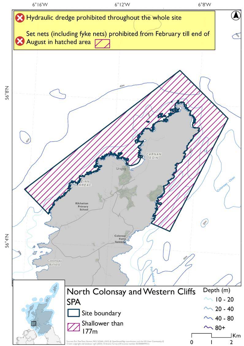
Option 1
- Set nets (including fyke nets) prohibited from February till end of August in areas down to 177m based on presence and maximum dive depth of guillemot
- Full site closure to hydraulic dredge
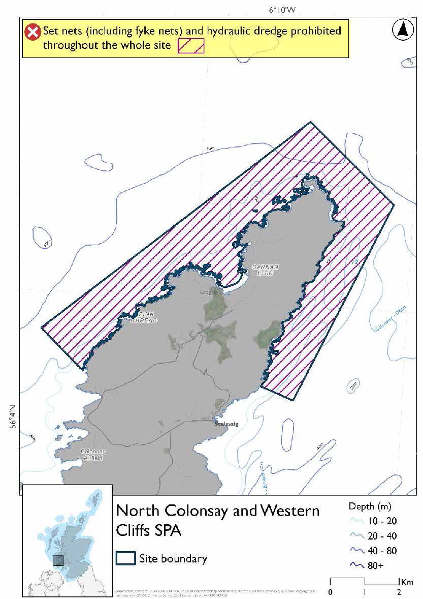
Option 2
- Full site closure to set nets (including fyke nets) and hydraulic dredge
Overlapping site included in this consultation
This SPA overlaps with the Inner Hebrides and the Minches SAC.
Rationale for developed measures
The basis for the proposed fisheries management measures for each site has been determined by the management advice for fishing activities provided by NatureScot, which can be found on their website or Sitelink as signposted throughout this document. The Fisheries Assessment for each site assesses the impacts from existing fishing activities on the protected features using the tests from the legislation relevant for the type of MPA being considered. The assessment outlines how the proposed measures address any impacts identified that could hinder the conservation objectives of the MPA.
7.7.7 Other fisheries management measures currently applying to this site
There are already management measures in place. An effort has been made to identify existing measures which affect each individual site or area, however the list may not be exhaustive. These measures are outlined below, and the proposals for further management being consulted on now are in addition to these existing measures:
- Fishing for sandeel is prohibited within the Scottish zone, which is defined as the sea adjacent to Scotland up to the 200 nautical miles limit
Other conservation measures can be found in section 7 of the CMA.
Contact
Email: marine_biodiversity@gov.scot