
Fisheries Management Measures within Scottish Inshore Marine Protected Areas (MPAs) and Proposed Priority Marine Feature (PMF) Management Areas - Site and Area Proposal Document
This document describes the process, justification and evidence used to develop site and area specific fisheries management measures. It outlines key information for each site and area including their features, and risks of potential pressures.

23. Proposed PMF management areas in the Outer Hebrides marine region
23.1 East Loch Tarbert and Scalpay (Harris)
23.1.1 Description and background*
East Loch Tarbert and Scalpay (Harris) proposed PMF management area covers two discrete areas, the inner portion of Loch Tarbert stopping just short of the west coast of Scatasay, and the waters surrounding Scalpay and its surrounding islets. This area has been selected to protect:
- Horse mussel beds;
- Maerl beds;
- Maerl or coarse shell gravel with burrowing sea cucumbers; and
- Northern sea fan and sponge communities
*This proposed PMF management area overlaps with the Inner Hebrides and the Minches SAC.
23.1.2 Fisheries management measures proposed
PMF management areas will be closed to demersal trawls and seines, beam trawls, mechanical dredges, and hydraulic dredges. This is because the features present in these areas are sensitive to these gear types.
This PMF management area overlaps with management measures being consulted on for Inner Hebrides and the Minches SAC for set nets (not including fyke nets) which are not shown in the maps below.
Please check overlapping site map option(s) to see static gear measures.
23.1.3 Options under consideration
Two options have been developed for this for this PMF management area. Option 1 reflects a smaller footprint that reflects one, or a combination of evidence (fishing activity or PMF related), boundary setting principles and compliance considerations. Option 2 covers a larger footprint that offers improved protection.
Option 2 has a northern sea fan and sponge communities record that is not captured in Option 1 as this is a single, pre-2000, record.
Option 1: This boundary covers a smaller footprint in two discrete locations, and excludes the most westerly northern sea fan and sponge communities record. A reduction was made to accommodate fishing activity as much as possible with suitable buffers applied around the protected features.
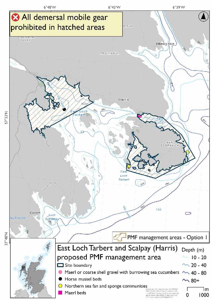
*The northern sea fan and sponge communities record directly south of the maerl bed record is completely covering the maerl or coarse shell gravel with burrowing sea cucumbers record
Option 2: This boundary covers a larger footprint including the most westerly PMF northern sea fan and sponge communities record.
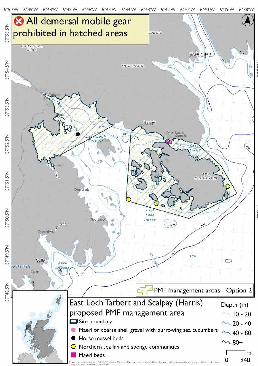
*The northern sea fan and sponge communities record directly south of the maerl bed record is completely covering the maerl or coarse shell gravel with burrowing sea cucumbers record
23.1.4 Other fisheries management measures currently applying to this area
There are already management measures in place. An effort has been made to identify existing measures which affect each individual site or area, however the list may not be exhaustive. These measures are outlined below, and the proposals for further management being consulted on now are in addition to these existing measures:
- Fishing for sandeel is prohibited within the Scottish zone, which is defined as the sea adjacent to Scotland up to the 200 nautical miles limit
23.2 East of Mingulay
23.2.1 Description and background*
East of Mingulay proposed PMF management area occupies a small patch of open waters halfway between Barra and Tiree. This area was selected to protect:
- Northern sea fan and sponge communities
*This proposed PMF management area overlaps with the Sea of the Hebrides NCMPA.
23.2.2 Fisheries management measures proposed
PMF management areas will be closed to demersal trawls and seines, beam trawls, mechanical dredges, and hydraulic dredges. This is because the features present in these areas are sensitive to these gear types.
This PMF management area overlaps with management measures being consulted on for Sea of the Hebrides NCMPA for set nets (not including fyke nets) which are not shown in the maps below.
Please check overlapping site map option(s) to see static gear measures.
23.2.3 Options under consideration
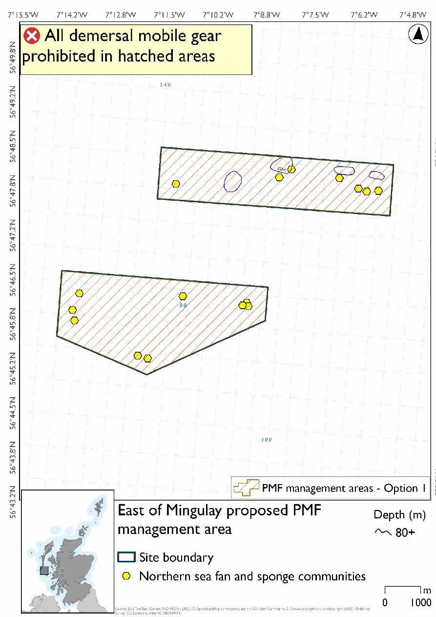
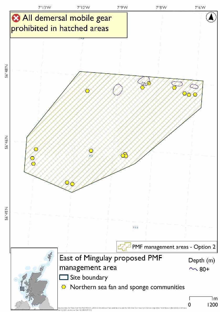
Two options have been developed for this for this PMF management area. Option 1 reflects a smaller footprint that reflects one, or a combination of evidence (fishing activity or PMF related), boundary setting principles and compliance considerations. Option 2 covers a larger footprint that offers improved protection.
Option 1: This boundary covers a smaller footprint and is over two discrete locations closely following extent of PMF point records. A reduction was made to accommodate fishing activity as much as possible with suitable buffers applied around the protected features.
Option 2: This boundary covers a larger footprint that offers improved protection.
23.2.4 Other fisheries management measures currently applying to this area
There are already management measures in place. An effort has been made to identify existing measures which affect each individual site or area, however the list may not be exhaustive. These measures are outlined below, and the proposals for further management being consulted on now are in addition to these existing measures:
- Fishing for sandeel is prohibited within the Scottish zone, which is defined as the sea adjacent to Scotland up to the 200 nautical miles limit
23.3 Loch Aineort (South Uist)
23.3.1 Description and background
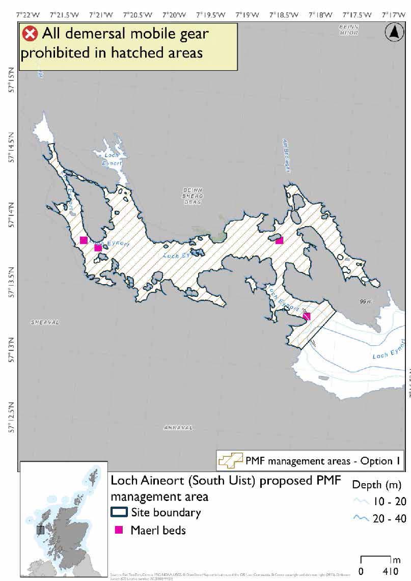
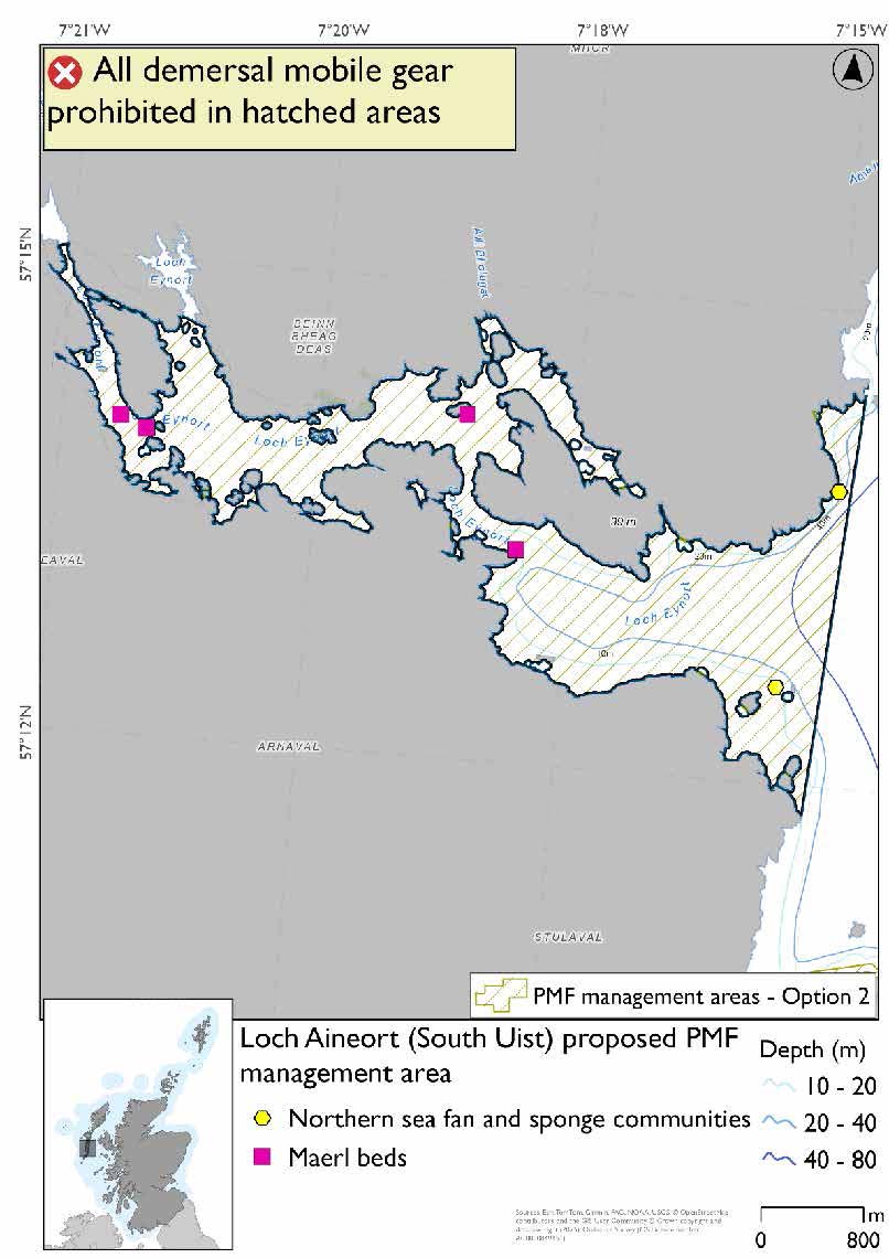
Loch Aineort (South Uist) proposed PMF management area covers the waters of Loch Aineort on South Uist, and the waters immediately outside it. This area has been selected to protect:
- Maerl beds
There are also northern sea fan and sponge communities records present in Option 2, but they were not a focus for this area selection.
23.3.2 Fisheries management measures proposed
PMF management areas will be closed to demersal trawls and seines, beam trawls, mechanical dredges, and hydraulic dredges. This is because the features present in these areas are sensitive to these gear types.
23.3.3 Options under consideration
Two options have been developed for this for this PMF management area. Option 1 reflects a smaller footprint that reflects one, or a combination of evidence (fishing activity or PMF related), boundary setting principles and compliance considerations. Option 2 covers a larger footprint that offers improved protection.
No additional fishing data were provided within the proposed PMF management areas.
Option 1: This boundary covers a smaller footprint, excluding the outer mouth of Loch Aineort and the northern sea fan and sponge communities records.
Option 2: This boundary covers a larger footprint that includes the outer mouth of Loch Aineort and two northern sea fan and sponge communities records which are not the primary focus for this area selection.
23.3.4 Other fisheries management measures currently applying to this area
There are already management measures in place. An effort has been made to identify existing measures which affect each individual site or area, however the list may not be exhaustive. These measures are outlined below, and the proposals for further management being consulted on now are in addition to these existing measures:
- Suction dredge prohibited all year in part of the area
- Fishing for any species of sea fish except king scallops and queen scallops with a trawl, Danish seine or similar net, purse seine, ring net or dredge between 1st March and 31st October in each year in part of the area
- All methods of fishing for king scallops or queen scallops between 1st March and 30th April in each year in part of the area
- All methods of fishing for king scallops or queen scallops between 25th August and 31st October in each year in part of the area
- Fishing for sandeel is prohibited within the Scottish zone, which is defined as the sea adjacent to Scotland up to the 200 nautical miles limit
23.4 Stulaigh (South Uist)
23.4.1 Description and background
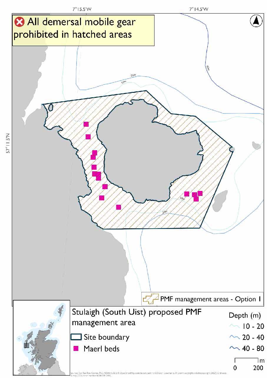
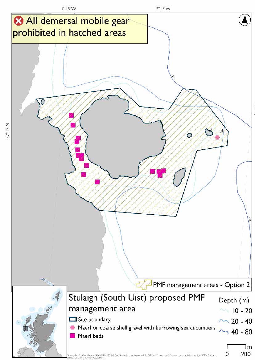
Stulaigh (South Uist) proposed PMF management area covers the waters surrounding Stulaigh up to the South Uist Coast and the small islets to the east. This area was selected to protect:
- Maerl beds;
There are also maerl or coarse shell gravel with burrowing sea cucumbers records present in Option 2, but they were not the focus for this area selection.
23.4.2 Fisheries management measures proposed
PMF management areas will be closed to demersal trawls and seines, beam trawls, mechanical dredges, and hydraulic dredges. This is because the features present in these areas are sensitive to these gear types.
23.4.3 Options under consideration
Two options have been developed for this for this PMF management area. Option 1 reflects a smaller footprint that reflects one, or a combination of evidence (fishing activity or PMF related), boundary setting principles and compliance considerations. Option 2 covers a larger footprint that offers improved protection.
Option 1: This boundary covers a smaller footprint that more closely follows maerl bed records and habitat of a depth suitable for maerl beds. It also accommodates the fishing activity based on the data provided.
Option 2: This boundary covers a larger footprint including a maerl or coarse shell gravel with burrowing sea cucumbers record and habitat of depths suitable for maerl beds to the east and south.
23.4.4 Other fisheries management measures currently applying to this area
There are already management measures in place. An effort has been made to identify existing measures which affect each individual site or area, however the list may not be exhaustive. These measures are outlined below, and the proposals for further management being consulted on now are in addition to these existing measures:
- Fishing for sandeel is prohibited within the Scottish zone, which is defined as the sea adjacent to Scotland up to the 200 nautical miles limit
- Dredging (but not suction dredging) for scallops prohibited in part of the area from 1 May till 24 August each year
- Suction dredge prohibited all year in part of the area Fishing for any species of sea fish except king scallops and queen scallops with a trawl, Danish seine or similar net, purse seine, ring net or dredge between 1st March and 31st October in each year in part of the area
- All methods of fishing for king scallops or queen scallops between 1st March and 30th April in each year in part of the area
- All methods of fishing for king scallops or queen scallops between 25th August and 31st October in each year in part of the area
23.5 Loch Baghasdail (South Uist)
23.5.1 Description and background
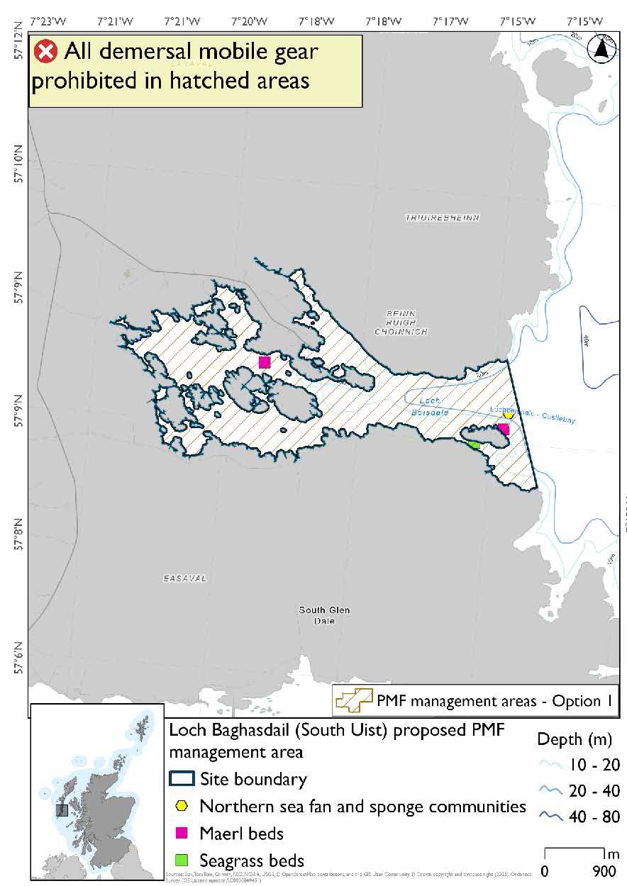
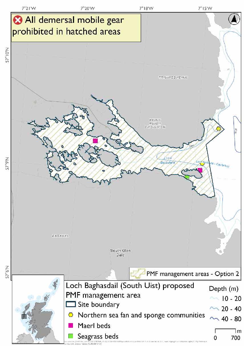
Loch Baghasdail (South Uist) proposed PMF management area covers the waters of Loch Baghasdail out to just past Calbhaigh. This area was selected to protect:
- Maerl beds;
- Northern sea fan and sponge communities, and
- Seagrass beds
23.5.2 Fisheries management measures proposed
PMF management areas will be closed to demersal trawls and seines, beam trawls, mechanical dredges, and hydraulic dredges. This is because the features present in these areas are sensitive to these gear types.
23.5.3 Options under consideration
Two options have been developed for this for this PMF management area. Option 1 reflects a smaller footprint that reflects one, or a combination of evidence (fishing activity or PMF related), boundary setting principles and compliance considerations. Option 2 covers a larger footprint that offers improved protection.
Option 2 has a northern sea fan and sponge communities record not captured in Option 1 as it could be naturally protected by the topography here (stepped bedrock).
Option 1: This boundary covers a smaller footprint that more closely follows maerl bed and seagrass records and incorporates a record of northern sea fan and sponge communities. Additional fishing data were provided and have been accommodated where possible.
Option 2: This boundary covers a larger footprint at the mouth of the loch that includes a northern sea fan and sponge communities record.
23.5.4 Other fisheries management measures currently applying to this area
There are already management measures in place. An effort has been made to identify existing measures which affect each individual site or area, however the list may not be exhaustive. These measures are outlined below, and the proposals for further management being consulted on now are in addition to these existing measures:
- Dredging (but not suction dredging) for scallops prohibited in part of the area from 1 May till 24 August each year
- Fishing for sandeel is prohibited within the Scottish zone, which is defined as the sea adjacent to Scotland up to the 200 nautical miles limit
23.6 Loch Seaforth (Lewis)
23.6.1 Description and background
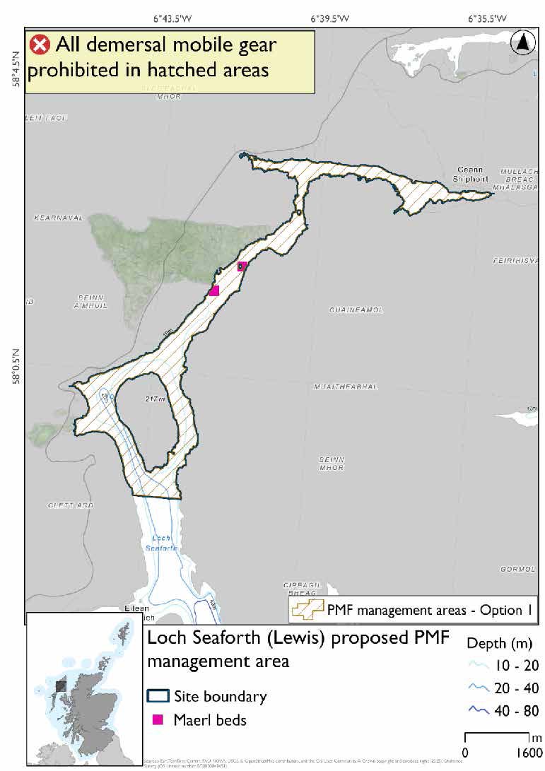
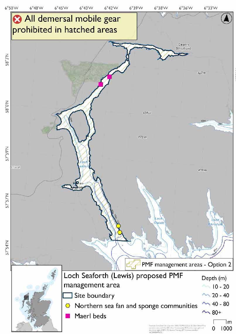
Loch Seaforth (Lewis) proposed PMF management area covers the entire inland area of Loch Seaforth, extending to the mouth of the loch at Rhenigdale. This area was selected to protect:
- Maerl beds
There are also northern sea fan and sponge communities records present in Option 2, but they were not the focus for this area selection.
23.6.2 Fisheries management measures proposed
PMF management areas will be closed to demersal trawls and seines, beam trawls, mechanical dredges, and hydraulic dredges. This is because the features present in these areas are sensitive to these gear types.
23.6.3 Options under consideration
Two options have been developed for this for this PMF management area. Option 1 reflects a smaller footprint that reflects one, or a combination of evidence (fishing activity or PMF related), boundary setting principles and compliance considerations. Option 2 covers a larger footprint that offers improved protection.
No additional fishing data were provided within the proposed PMF management areas.
Option 1: This boundary covers a smaller footprint focussed on the maerl bed records towards the head of the loch.
Option 2: This boundary covers a larger footprint and extends to cover northern sea fan and sponge communities at the mouth of the loch. There is a northern sea fan and sponge communities record excluded that lies outside the boundary for this option as it is a record from 1988.
23.6.4 Other fisheries management measures currently applying to this area
There are already management measures in place. An effort has been made to identify existing measures which affect each individual site or area, however the list may not be exhaustive. These measures are outlined below, and the proposals for further management being consulted on now are in addition to these existing measures:
- Fishing for sandeel is prohibited within the Scottish zone, which is defined as the sea adjacent to Scotland up to the 200 nautical miles limit
23.7 Lochs Tamnabhaigh, Tealasbaigh, Reasort, and Crabhadail (Harris)
23.7.1 Description and background
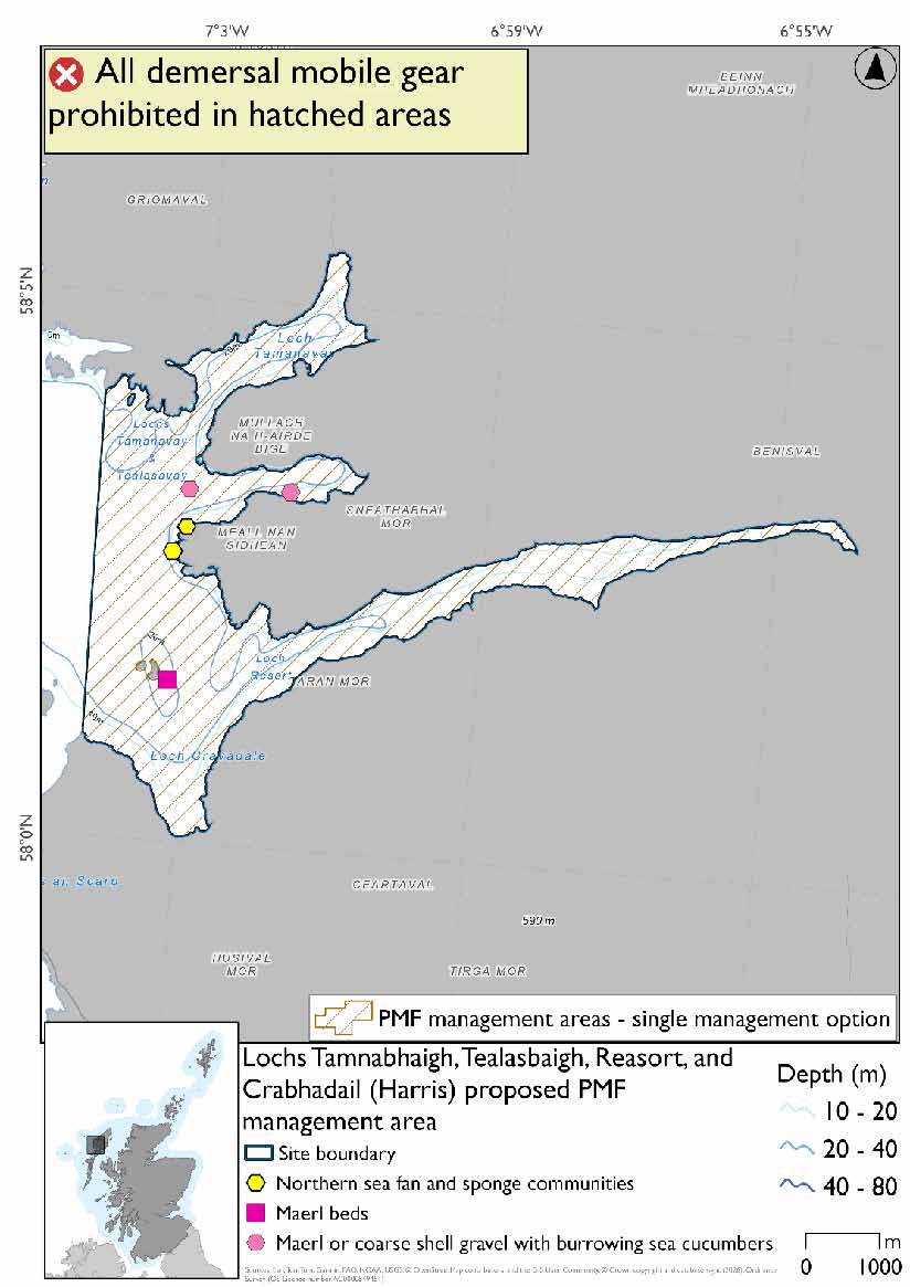
Lochs Tamnabhaigh, Tealasbaigh, Reasort, and Crabhadail (Harris) proposed PMF management area covers the waters of Lochs Tamnabhaigh, Tealasbaigh, Reasort, and Crabhadail; and the area of sea between them. This area was selected to protect:
- Maerl beds;
- Maerl or coarse shell gravel with burrowing sea cucumbers; and
- Northern sea fan and sponge communities
23.7.2 Fisheries management measures proposed
PMF management areas will be closed to demersal trawls and seines, beam trawls, mechanical dredges, and hydraulic dredges. This is because the features present in these areas are sensitive to these gear types.
23.7.3 Options under consideration
A single management option has been developed for this PMF management area. Only one option was identified due to one of, or combination of, evidence (fishing activity or PMF related), boundary setting principles and compliance considerations.
The boundary was developed to encompass the records of these features and no additional fishing data were provided within the proposed PMF management area.
23.7.4 Other fisheries management measures currently applying to this area
There are already management measures in place. An effort has been made to identify existing measures which affect each individual site or area, however the list may not be exhaustive. These measures are outlined below, and the proposals for further management being consulted on now are in addition to these existing measures:
- Fishing for sandeel is prohibited within the Scottish zone, which is defined as the sea adjacent to Scotland up to the 200 nautical miles limit
23.8 Pabaigh, South-East (Sound of Harris)
23.8.1 Description and background*
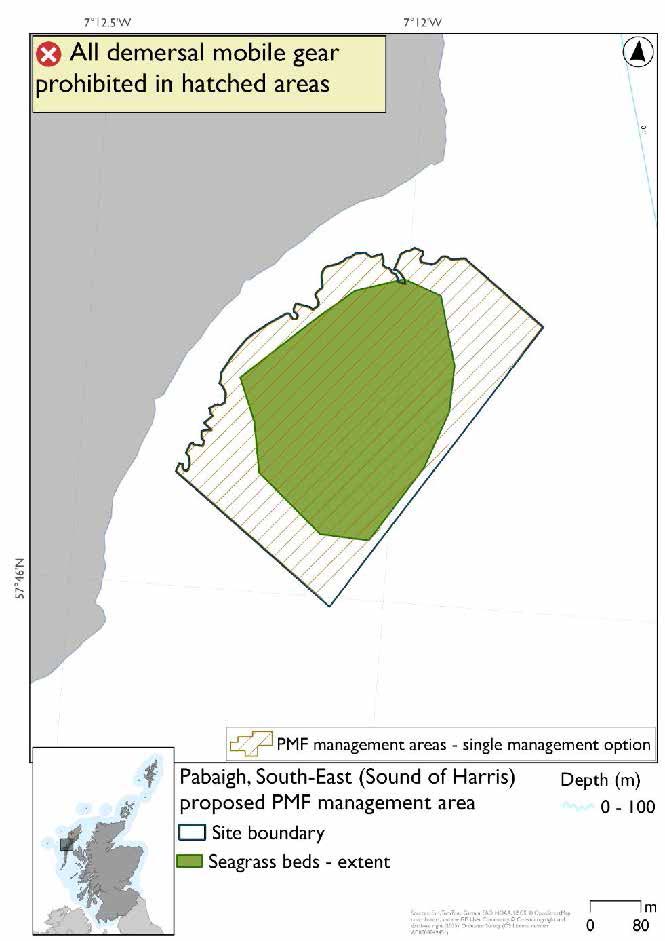
Pabaigh, South-East (Sound of Harris) proposed PMF management area covers a small area on the southeast coast of Pabaigh. This area was selected to protect:
- Seagrass beds
*This proposed PMF management area overlaps with the West Coast of the Outer Hebrides SPA.
23.8.2 Fisheries management measures proposed
PMF management areas will be closed to demersal trawls and seines, beam trawls, mechanical dredges, and hydraulic dredges. This is because the features present in these areas are sensitive to these gear types.
This PMF management area overlaps with management measures being consulted on for West Coast of the Outer Hebrides SPA for set nets (including fyke nets) which are not shown in the maps below.
Please check overlapping site map option(s) to see static gear measures.
23.8.3 Options under consideration
A single management option has been developed for this PMF management area. Only one option was identified due to one of, or combination of, evidence (fishing activity or PMF related), boundary setting principles and compliance considerations.
This was developed to closely follow the extent of the seagrass bed polygon and no additional fishing data were provided within the proposed PMF management area.
23.8.4 Other fisheries management measures currently applying to this area
There are already management measures in place. An effort has been made to identify existing measures which affect each individual site or area, however the list may not be exhaustive. These measures are outlined below, and the proposals for further management being consulted on now are in addition to these existing measures:
- Fishing for any species of sea fish with a suction dredge is prohibited
- Fishing for sandeel is prohibited within the Scottish zone, which is defined as the sea adjacent to Scotland up to the 200 nautical miles limit
23.9 Pabaigh, South (Sound of Harris)
23.9.1 Description and background*
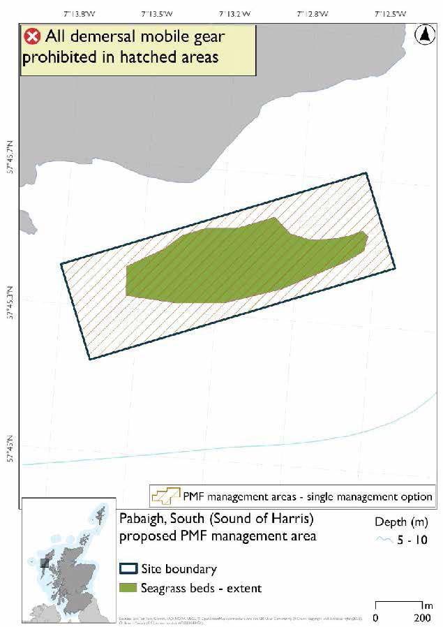
Pabaigh, South, (Sound of Harris) proposed PMF management area covers an area just to the south of Pabaigh. This area has been selected to protect:
- Seagrass beds
*This proposed PMF management area overlaps with the West Coast of the Outer Hebrides SPA.
23.9.2 Fisheries management measures proposed
PMF management areas will be closed to demersal trawls and seines, beam trawls, mechanical dredges, and hydraulic dredges. This is because the features present in these areas are sensitive to these gear types.
This PMF management area overlaps with management measures being consulted on for West Coast of the Outer Hebrides SPA for set nets (including fyke nets) which are not shown in the maps below.
Please check overlapping site map option(s) to see static gear measures.
23.9.3 Options under consideration
A single management option has been developed for this PMF management area. Only one option was identified due to one of, or combination of, evidence (fishing activity or PMF related), boundary setting principles and compliance considerations.
This was developed to closely follow the extent of the seagrass bed polygon and no additional fishing data were provided within the proposed PMF management area.
23.9.4 Other fisheries management measures currently applying to this area
There are already management measures in place. An effort has been made to identify existing measures which affect each individual site or area, however the list may not be exhaustive. These measures are outlined below, and the proposals for further management being consulted on now are in addition to these existing measures:
- Fishing for any species of sea fish with a suction dredge is prohibited
- Fishing for sandeel is prohibited within the Scottish zone, which is defined as the sea adjacent to Scotland up to the 200 nautical miles limit
23.10 Aird an t-Sruith (Sound of Harris)
23.10.1 Description and background*
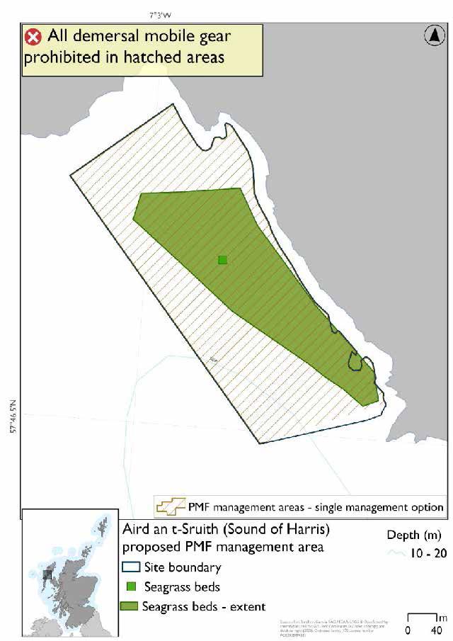
Aird an t-Sruith (Sound of Harris) proposed PMF management area covers a small area to the northwest of Leverburgh in the Sound of Harris. This area has been selected to protect:
- Seagrass beds
*This proposed PMF management area overlaps with the West Coast of the Outer Hebrides SPA.
23.10.2 Fisheries management measures proposed
PMF management areas will be closed to demersal trawls and seines, beam trawls, mechanical dredges, and hydraulic dredges. This is because the features present in these areas are sensitive to these gear types.
This PMF management area overlaps with management measures being consulted on for West Coast of the Outer Hebrides SPA for set nets (including fyke nets) which are not shown in the maps below.
Please check overlapping site map option(s) to see static gear measures.
23.10.3 Options under consideration
A single management option has been developed for this PMF management area. Only one option was identified due to one of, or combination of, evidence (fishing activity or PMF related), boundary setting principles and compliance considerations.
This was developed to closely follow the extent of the seagrass bed polygon and no additional fishing data were provided within the proposed management area. Point data and polygon data for seagrass beds are shown in the map.
23.10.4 Other fisheries management measures currently applying to this area
There are already management measures in place. An effort has been made to identify existing measures which affect each individual site or area, however the list may not be exhaustive. These measures are outlined below, and the proposals for further management being consulted on now are in addition to these existing measures:
- Fishing for any species of sea fish with a suction dredge is prohibited
- Fishing for sandeel is prohibited within the Scottish zone, which is defined as the sea adjacent to Scotland up to the 200 nautical miles limit
23.11. Easaigh and Celeigraigh (Sound of Harris)
23.11.1 Description and background*
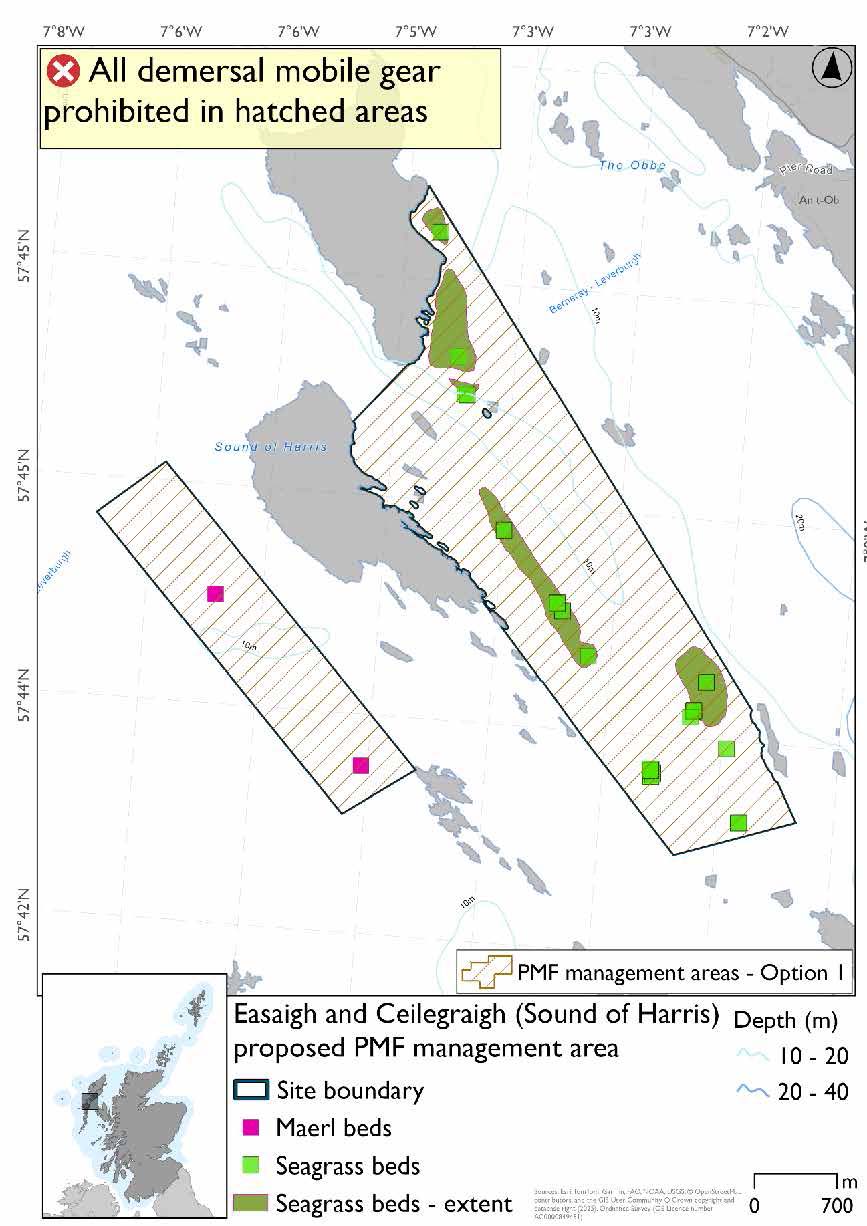
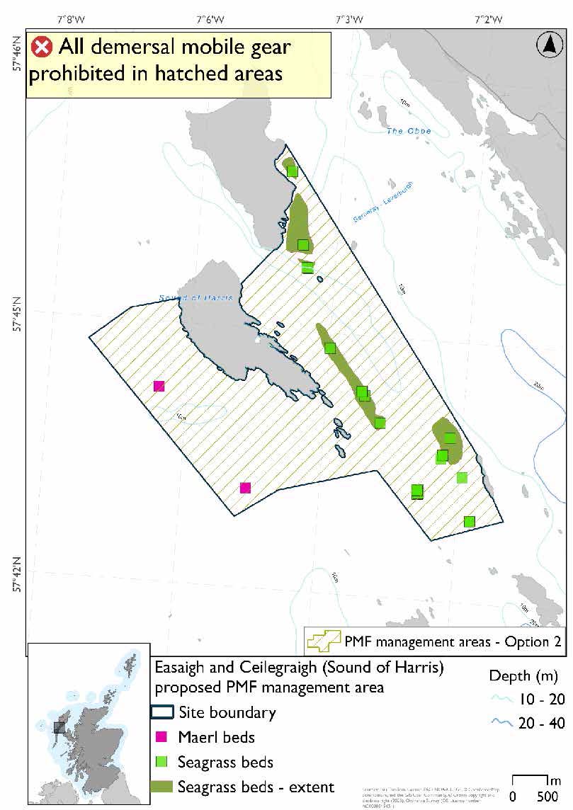
Easaigh and Ceilegraigh (Sound of Harris) proposed PMF management area covers the southeastern coast of Easaigh, the southern and eastern coasts of Ceilegraigh, and the waters south and east of these islands. This area has been selected to protect:
- Maerl beds; and
- Seagrass beds
*This proposed PMF management area overlaps with the West Coast of the Outer Hebrides SPA.
23.11.2 Fisheries management measures proposed
PMF management areas will be closed to demersal trawls and seines, beam trawls, mechanical dredges, and hydraulic dredges. This is because the features present in these areas are sensitive to these gear types.
This PMF management area overlaps with management measures being consulted on for West Coast of the Outer Hebrides SPA for set nets (including fyke nets) which are not shown in the maps below.
Please check overlapping site map option(s) to see static gear measures.
23.11.3 Options under consideration
Two options have been developed for this for this PMF management area. Option 1 reflects a smaller footprint that reflects one, or a combination of evidence (fishing activity or PMF related), boundary setting principles and compliance considerations. Option 2 covers a larger footprint that offers improved protection.
No additional fishing data were provided within the proposed PMF management areas.
Option 1: This boundary covers a smaller footprint composed of two discrete locations that encompass maerl bed and seagrass bed records.
Option 2: This boundary covers a larger footprint that merges the two discrete locations in Option 1, and includes additional suitable habitat that could support maerl beds or potentially maerl or coarse shell gravel with burrowing sea cucumbers.
23.11.4 Other fisheries management measures currently applying to this area
There are already management measures in place. An effort has been made to identify existing measures which affect each individual site or area, however the list may not be exhaustive. These measures are outlined below, and the proposals for further management being consulted on now are in addition to these existing measures:
- Fishing for any species of sea fish with a suction dredge is prohibited
- Fishing for sandeel is prohibited within the Scottish zone, which is defined as the sea adjacent to Scotland up to the 200 nautical miles limit
23.12 Berneray (East) Sound of Harris
23.12.1 Description and background*
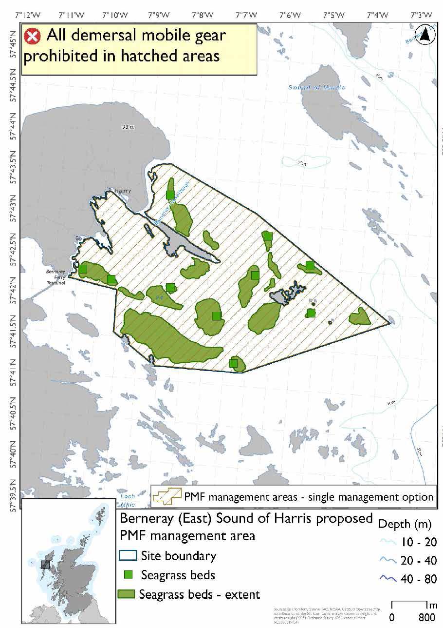
Berneray (East) Sound of Harris proposed PMF management area covers an area of waters extending eastwards some way from Berneray in the Sound of Harris. This area has been selected to protect:
- Seagrass beds
*This proposed PMF management area overlaps with the West Coast of the Outer Hebrides SPA.
23.12.2 Fisheries management measures proposed
PMF management areas will be closed to demersal trawls and seines, beam trawls, mechanical dredges, and hydraulic dredges. This is because the features present in these areas are sensitive to these gear types.
This PMF management area overlaps with management measures being consulted on for West Coast of the Outer Hebrides SPA for set nets (including fyke nets) which are not shown in the maps below.
Please check overlapping site map option(s) to see static gear measures.
23.12.3 Options under consideration
A single management option has been developed for this PMF management area. Only one option was identified due to one of, or combination of, evidence (fishing activity or PMF related), boundary setting principles and compliance considerations.
This was developed to include known seagrass bed records and no additional fishing data were provided within the proposed PMF management area. Point data and polygon data for seagrass beds are shown in the map.
23.12.4 Other fisheries management measures currently applying to this area
There are already management measures in place. An effort has been made to identify existing measures which affect each individual site or area, however the list may not be exhaustive. These measures are outlined below, and the proposals for further management being consulted on now are in addition to these existing measures:
- Fishing for any species of sea fish with a suction dredge is prohibited
- Fishing for sandeel is prohibited within the Scottish zone, which is defined as the sea adjacent to Scotland up to the 200 nautical miles limit
23.13 Boreray and Berneray (North Uist)
23.13.1 Description and background*
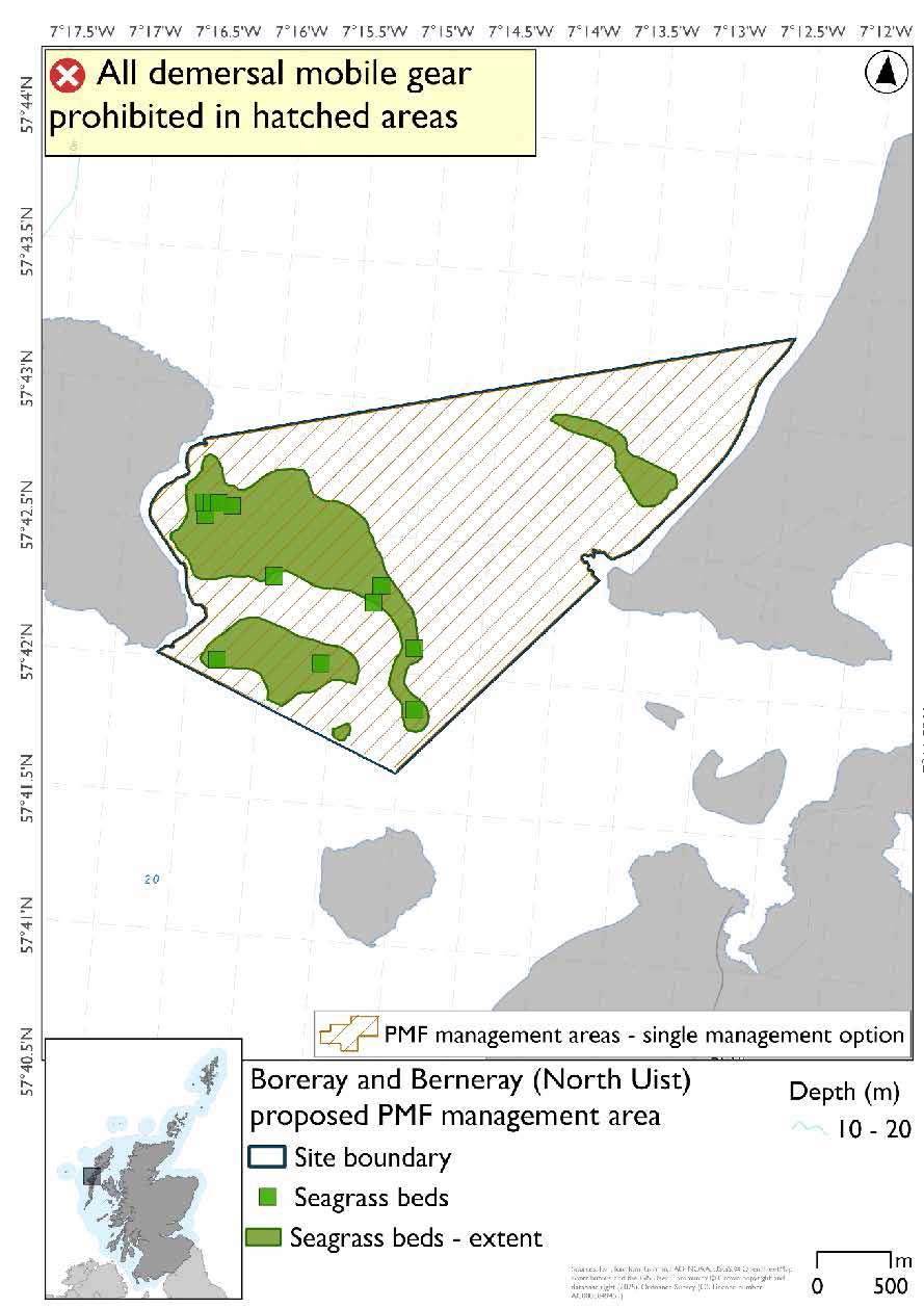
Boreray and Berneray (North Uist) proposed PMF management area covers a patch of water between the east coast of Boreray and the southwest coast of Berneray. This area has been selected to protect:
- Seagrass beds
*This proposed PMF management area overlaps with the West Coast of the Outer Hebrides SPA.
23.13.2 Fisheries management measures proposed
PMF management areas will be closed to demersal trawls and seines, beam trawls, mechanical dredges, and hydraulic dredges. This is because the features present in these areas are sensitive to these gear types.
This PMF management area overlaps with management measures being consulted on for West Coast of the Outer Hebrides SPA for set nets (including fyke nets) which are not shown in the maps below.
Please check overlapping site map option(s) to see static gear measures.
23.13.3 Options under consideration
A single management option has been developed for this PMF management area. Only one option was identified due to one of, or combination of, evidence (fishing activity or PMF related), boundary setting principles and compliance considerations.
This was developed to include known seagrass bed records and no additional fishing data were provided within the proposed PMF management area. Point data and polygon data for seagrass beds are shown in the map.
23.13.4 Other fisheries management measures currently applying to this area
There are already management measures in place. An effort has been made to identify existing measures which affect each individual site or area, however the list may not be exhaustive. These measures are outlined below, and the proposals for further management being consulted on now are in addition to these existing measures:
- Fishing for any species of sea fish with a suction dredge is prohibited
- Fishing for sandeel is prohibited within the Scottish zone, which is defined as the sea adjacent to Scotland up to the 200 nautical miles limit
23.14 Rangas, Bhotarsaigh, and Sursaigh (North Uist)
23.14.1 Description and background*
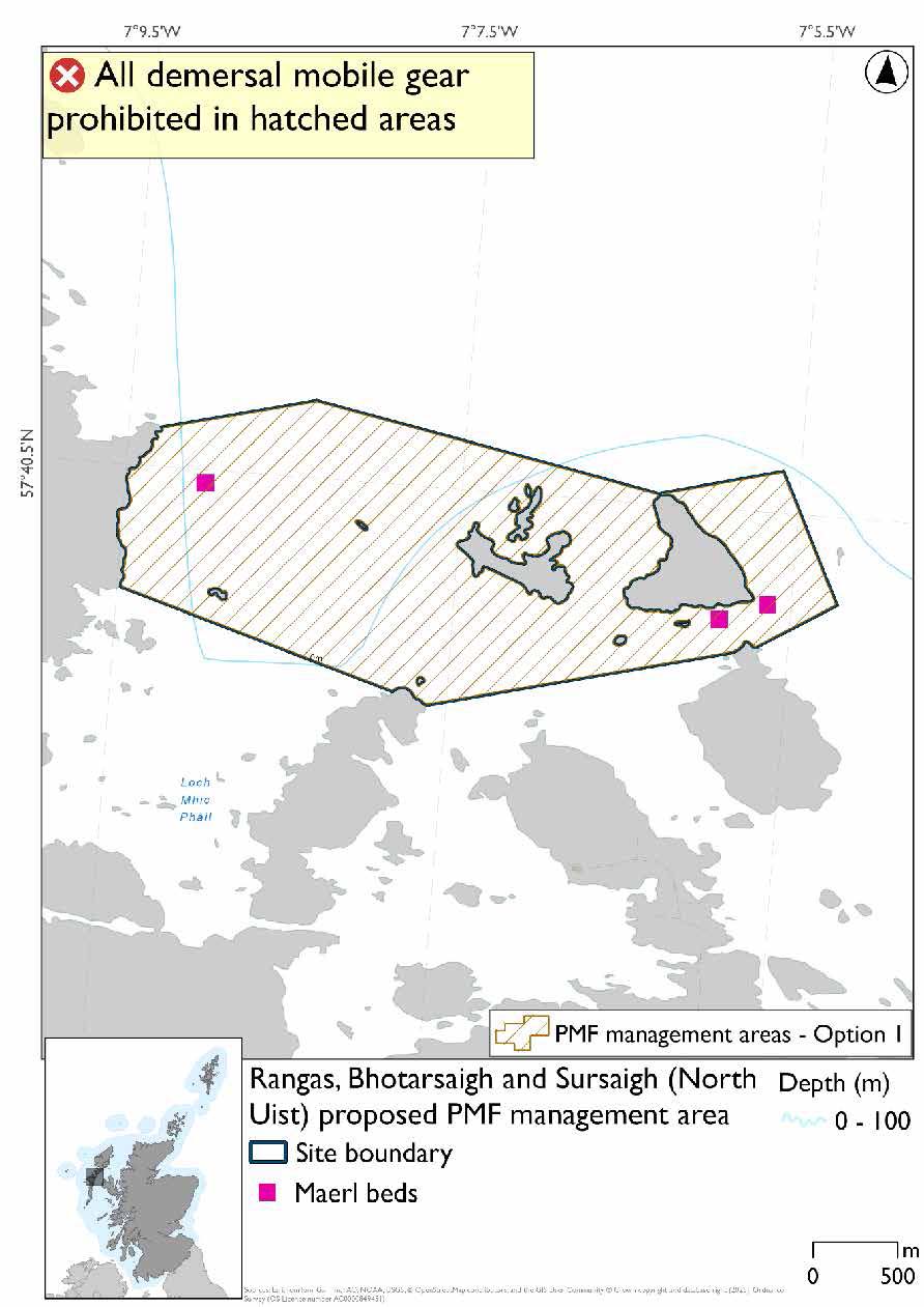
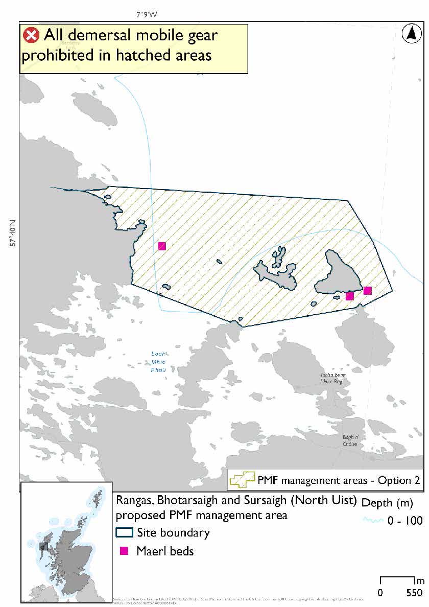
Rangas, Bhotarsaigh and Sursaigh (North Uist) proposed PMF management area covers the waters from Sursaigh westwards to the North Uist mainland. This area has been selected to protect:
- Maerl beds
*This proposed PMF management area overlaps with the West Coast of the Outer Hebrides SPA.
23.14.2 Fisheries management measures proposed
PMF management areas will be closed to demersal trawls and seines, beam trawls, mechanical dredges, and hydraulic dredges. This is because the features present in these areas are sensitive to these gear types.
This PMF management area overlaps with management measures being consulted on for West Coast of the Outer Hebrides SPA for set nets (including fyke nets) which are not shown in the maps below.
Please check overlapping site map option(s) to see static gear measures.
23.14.3 Options under consideration
Two options have been developed for this for this PMF management area. Option 1 reflects a smaller footprint that reflects one, or a combination of evidence (fishing activity or PMF related), boundary setting principles and compliance considerations. Option 2 covers a larger footprint that offers improved protection.
No additional fishing data were provided within the proposed PMF management areas.
Option 1: This boundary covers a smaller footprint that includes the maerl bed records and uses simple boundary lines from headlands.
Option 2: This boundary covers a larger footprint with additional habitat of suitable depths for maerl beds.
23.14.4 Other fisheries management measures currently applying to this area
There are already management measures in place. An effort has been made to identify existing measures which affect each individual site or area, however the list may not be exhaustive. These measures are outlined below, and the proposals for further management being consulted on now are in addition to these existing measures:
- Fishing for any species of sea fish with a suction dredge is prohibited
- Fishing for sandeel is prohibited within the Scottish zone, which is defined as the sea adjacent to Scotland up to the 200 nautical miles limit
23.15 Sound of Taransay and West Loch Tarbert (Harris)
23.15.1 Description and background*
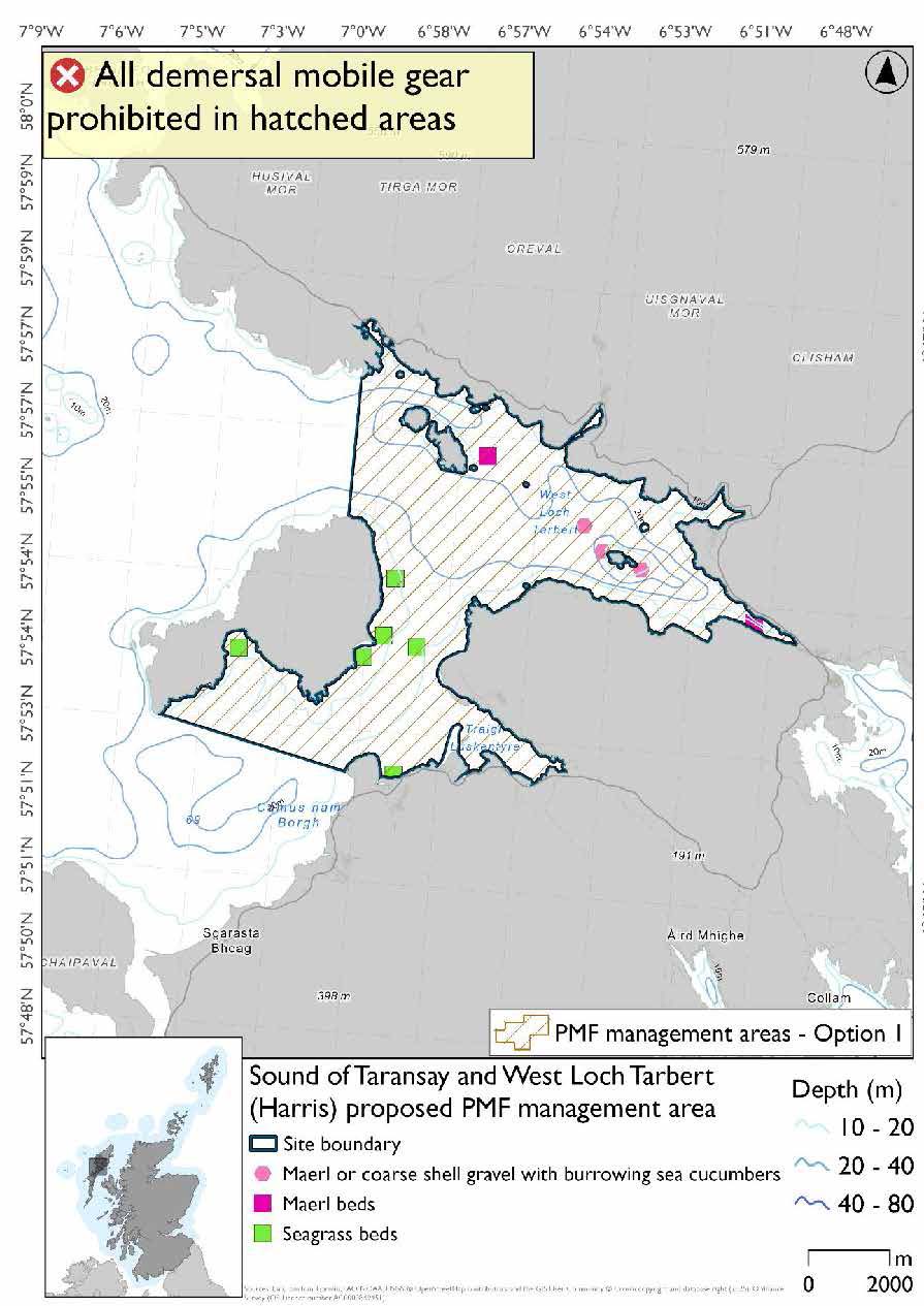
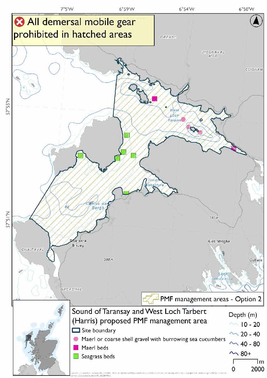
Sound of Taransay and West Loch Tarbert (Harris) proposed PMF management area covers the waters between the Harris mainland and Taransay and the sheltered area in which it sits, from Amhuinnsuidhe in the north to the peninsula southwest of Taransay. This area has been selected to protect:
- Maerl beds;
- Maerl or coarse shell gravel with burrowing sea cucumbers; and
- Seagrass beds
*This proposed PMF management area overlaps with the West Coast of the Outer Hebrides SPA.
23.15.2 Fisheries management measures proposed
PMF management areas will be closed to demersal trawls and seines, beam trawls, mechanical dredges, and hydraulic dredges. This is because the features present in these areas are sensitive to these gear types.
This PMF management area overlaps with management measures being consulted on for West Coast of the Outer Hebrides SPA for set nets (including fyke nets) which are not shown in the maps below.
Please check overlapping site map option(s) to see static gear measures.
23.15.3 Options under consideration
Two options have been developed for this for this PMF management area. Option 1 reflects a smaller footprint that reflects one, or a combination of evidence (fishing activity or PMF related), boundary setting principles and compliance considerations. Option 2 covers a larger footprint that offers improved protection.
No additional fishing data were provided within the proposed PMF management areas.
Option 1: This boundary covers a smaller footprint which more closely reflects the known PMF records.
Option 2: This boundary covers a larger footprint, which extends to the southwest including additional habitat at depths suitable for the PMFs.
23.15.4 Other fisheries management measures currently applying to this area
There are already management measures in place. An effort has been made to identify existing measures which affect each individual site or area, however the list may not be exhaustive. These measures are outlined below, and the proposals for further management being consulted on now are in addition to these existing measures:
- Fishing for any species of sea fish with a suction dredge is prohibited
- Fishing for sandeel is prohibited within the Scottish zone, which is defined as the sea adjacent to Scotland up to the 200 nautical miles limit
23.16 Sgeir an Fhèidh (South Uist)
23.16.1 Description and background
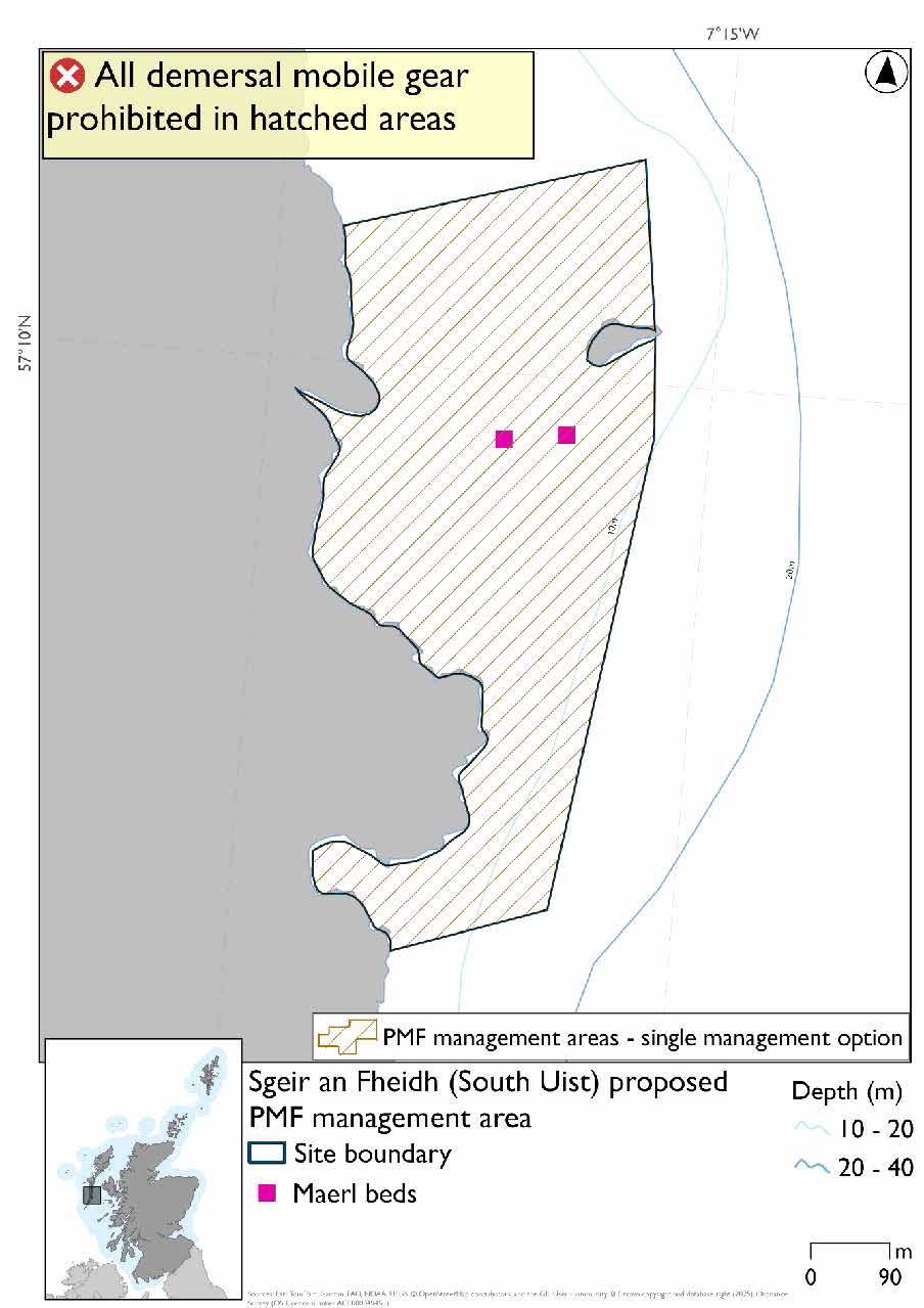
Sgeir an Fhèidh (South Uist) proposed PMF management area covers the waters surrounding Sgeir an Fhèidh across to the adjacent South Uist coast. This site was chosen to protect:
- Maerl beds
23.16.2 Fisheries management measures proposed
PMF management areas will be closed to demersal trawls and seines, beam trawls, mechanical dredges, and hydraulic dredges. This is because the features present in these areas are sensitive to these gear types.
23.16.3 Options under consideration
A single management option has been developed for this PMF management area. Only one option was identified due to one of, or combination of, evidence (fishing activity or PMF related), boundary setting principles and compliance considerations.
This was developed to include known maerl bed records and to accommodate additional fishing data provided.
23.16.4 Other fisheries management measures currently applying to this area
There are already management measures in place. An effort has been made to identify existing measures which affect each individual site or area, however the list may not be exhaustive. These measures are outlined below, and the proposals for further management being consulted on now are in addition to these existing measures:
- Dredging (but not suction dredging) for scallops prohibited in part of the site from 1 May till 24 August each year
- Fishing for sandeel is prohibited within the Scottish zone, which is defined as the sea adjacent to Scotland up to the 200 nautical miles limit
23.17 South-East Barra and Vatersay
23.17.1 Description and background
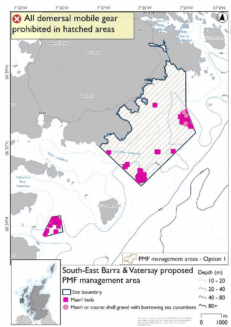
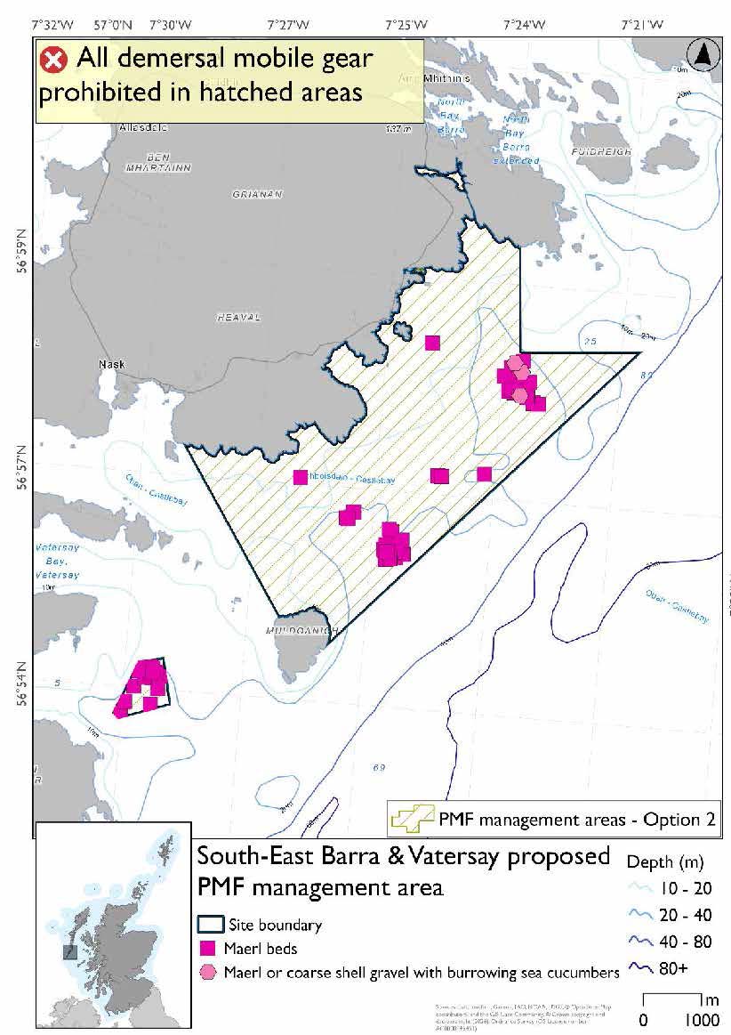
South-East Barra and Vatersay proposed PMF management area covers a small patch of waters southeast of Vatersay. This area has been selected to protect:
- Maerl beds; and
- Maerl or coarse shell gravel with burrowing sea cucumbers.
23.17.2 Fisheries management measures proposed
PMF management areas will be closed to demersal trawls and seines, beam trawls, mechanical dredges, and hydraulic dredges. This is because the features present in these areas are sensitive to these gear types.
23.17.3 Options under consideration
Two options have been developed for this for this PMF management area. Option 1 reflects a smaller footprint that reflects one, or a combination of evidence (fishing activity or PMF related), boundary setting principles and compliance considerations. Option 2 covers a larger footprint that offers improved protection.
No additional fishing data were provided within the proposed PMF management areas. Option 1: This boundary covers a smaller footprint that encompasses the PMF records and additional habitat at depths suitable for the PMFs. It partly follows the boundary of the Sound of Barra SAC in the north-east of the area.
Option 2: This boundary covers a larger footprint offering improved protection. It follows the boundary of the Sound of Barra SAC in the north-east of the area.
23.17.4 Other fisheries management measures currently applying to this area
There are already management measures in place. An effort has been made to identify existing measures which affect each individual site or area, however the list may not be exhaustive. These measures are outlined below, and the proposals for further management being consulted on now are in addition to these existing measures:
- Fishing for sandeel is prohibited within the Scottish zone, which is defined as the sea adjacent to Scotland up to the 200 nautical miles limit
Contact
Email: marine_biodiversity@gov.scot