Scotland's Fourth Land Use Strategy: supporting evidence pack
The evidence pack to support Scotland’s Fourth Land Use Strategy. It draws on published materials to provide a baseline understanding of land in Scotland, and aims to increase awareness of the interplay between landscape, land use and ecosystem services.
2 Current Land Uses – Where are we now?
2.1 What does Scotland’s land look like?
2.1.1 Elevation
Figure 1 shows Scotland at national scale with relief (elevation) displayed. This map was created by the James Hutton Institute used a mix of ESRI living atlas image services and Ordnance Survey data. Scotland has lowland areas in the central belt and northeast close to sea level. Scotland has mountainous upland areas, indicated by dark brown and white on the map, in its centre, northwest, and south. The use of the land in distinct geographies in Scotland will be driven partially by elevation; slope, climatic, and access constraints can limit how land is used in particular areas of the country.
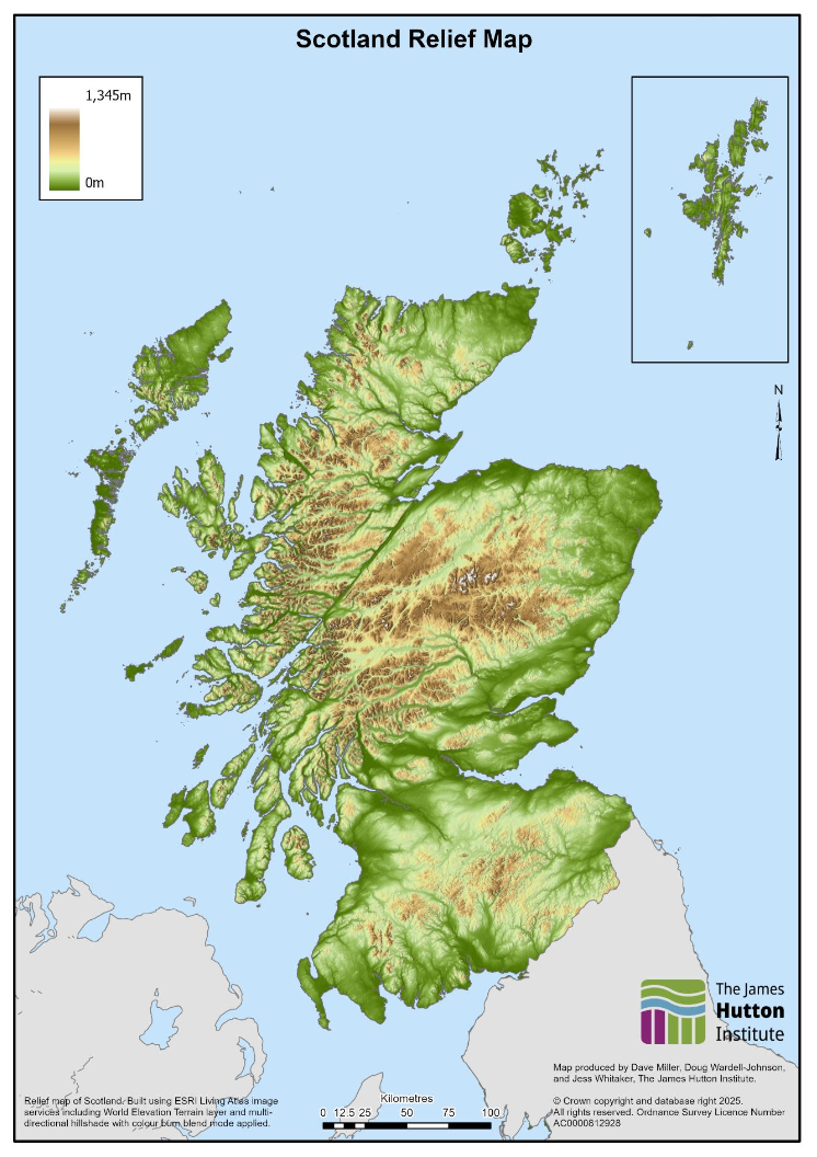
Source: ESRI Living Atlas World Elevation Terrain Image Service
2.1.2 Land Cover
Scotland’s land cover (the mix of plants, soils and human-made material on a piece of land) helps explain a critical dimension of Scotland’s varied land uses. The UK Centre for Ecology and Hydrology (UKCEH) produce annual maps of Scotland’s land cover that classify satellite images based on UK Habitat Classifications. These maps, produced annually, suit a wide variety of purposes and are comparable year-on-year. Table 1 shows the breakdown in Scotland’s land based on this land cover dataset in 2024, including intertidal areas but excluding inland water:
| Land Cover Class[2] | Area in Hectares (rounded to nearest 1,000) | Percent of Total Land (rounded to nearest tenth) |
|---|---|---|
| Rough and Semi-natural Grassland (including bog and heather) | 3,877,000 | 49.6% |
| Woodland | 1,472,000 | 18.8% |
| Improved Grassland | 1,408,000 | 18.0% |
| Arable and Horticulture | 586,000 | 7.5% |
| Other | 248,000 | 3.2% |
| Urban and Suburban Areas | 233,000 | 3.0% |
| Total | 7,824,000 | 100% |
Source: UKCEH Land Cover Map, 2024
Scotland’s land comprises 75% of grassland or cropland with almost 50% being rough grassland that isn’t intensively managed (this includes some peatland habitats like bog, as well as species-rich grasslands). Scotland’s cropland and improved grassland area is predominant in the central belt and east coast, with the highlands constituting the majority of the rough grassland area. Woodland area is spread across Scotland, with notable concentrations in the southwest and along major riverways. Figure 2 below shows Scotland’s land cover, using the UKCEH map from 2024 and aligned to the categories above.
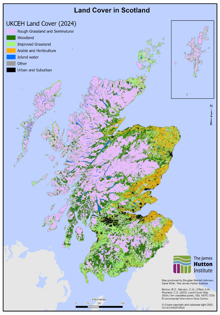
Source: UKCEH Land Cover Maps | UK Centre for Ecology & Hydrology
Another commonly referenced land cover map for Scotland, is the Habitat and Land Cover Map, which aligns earth observation data with European Nature Information System (EUNIS) habitats. This map is not as regularly updated and comparable to historical data as the UKCEH land cover maps, but does explore some habitat detail that the UKCEH maps do not. This report from the James Hutton Institute (JHI) summarises some of the key differences between these two land cover datasets.
Other maps exploring Scotland’s land cover, such as the Scottish Crop Map 2019 and the Habitat Map of Scotland, distinguish between land use classes and habitats in a degree of detail that remote sensing cannot. These maps however are constrained by not being produced annually, so are difficult to compare year-on-year. The Habitat Map of Scotland additionally is a composite dataset that provides good site-specific habitat data, but doesn’t have consistent coverage of habitats across all of Scotland’s land.
2.1.3 Soil and Peat
2.1.3.1 Soils in Scotland
The National Soil Map of Scotland illustrates the distribution of soil types across the country. Scottish soils vary widely in composition, depth, and capacity to support agriculture, forestry and carbon storage. Research funded through the 2022 to 2027 ENRA Research Programme is advancing the development of a soil route map for Scotland to inform future policymaking on soils.
Brown and mineral soils dominate the central belt, southern regions, and the northeast of Scotland, providing the most suitable conditions for productive agriculture. These soils support the majority of Scotland’s food production. In contrast, Scotland has a higher proportion of organic soils than the rest of the UK, with peat widely distributed across upland areas in the north and west, and smaller pockets in the southern uplands. Beyond agriculture, Scotland’s soils underpin a range of diverse habitats, supporting plant and animal life that relies on healthy soil ecosystems.
2.1.3.2 Peat and Peaty Soils
Peat soils are defined differently in Scotland than in other parts of the UK. Peat forms when dead plant material accumulates in cool, waterlogged conditions with limited oxygen, decomposing slowly into organic matter. Peat soils have a surface peat layer of at least 50 cm, and contain more than 60% organic matter. Peat soils are carbon-rich, and when in good condition, can store and sequester carbon.
Peaty soils, or organo-mineral soils, have a shallower surface peat layer – less than 50 cm – overlying mineral layers. Although they do not meet the depth threshold for peat soils, peaty soils remain ecologically important. They form part of the wider peatland complex and contribute to resilience and function of ecosystems. They also require attention due to their role in carbon storage and potential emissions.
2.1.3.3 Mapping of Soils and Peat
Mapping soils, including peat, spatially is a significant challenge. Peat depth and condition cannot be reliably and accurately observed from earth observation alone, and extensive field surveys – while more accurate – are time consuming and resource intensive. As a result, maps identifying the depth and coverage of peat in Scotland have high degrees of uncertainty and rely heavily on modelled data rather than field-validated condition assessments. This uncertainty is greatest where peat is beneath under other land uses, such as grassland, cropland, or forestry. Scottish Government aim to produce regular peatland statistics to explore peat data in depth.
Despite these limitations, available data indicates that Scotland contains extensive areas of peat. Figure 3 shows the map used to underpin the UK Greenhouse Gas Inventory, which estimates nearly 2 million hectares of peat soils with a surface peat layer over 50cm, representing close to a quarter of Scotland’s land area. According to the inventory map, around 70% (~1.4 million hectares) of Scotland’s peat is degraded, with most of this being modified bog across the northwest. Scotland’s most extensive area of Near Natural Bog is in the Flow Country. The above report describes the considerable uncertainty associated with this map, including significant errors in defining the boundary between peat soils and other soil types; the linked storymap explores how the inventory map contrasts with other peat research.
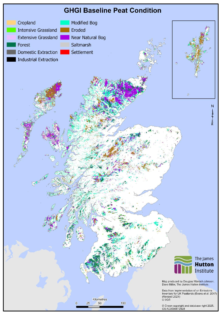
Source: Implementation of an Emissions Inventory for UK Peatlands
In a degraded condition, peatlands provide fewer benefits and ecosystem services, acting as a carbon source, rather than a carbon sink; section 2.6.1 explores this in more depth. Peatlands are sensitive ecosystems, vulnerable to damage or degradation by intensive use, drainage, or development. Climate change in Scotland, where warmer, drier conditions are expected, will increasingly put wetland habitats under stress.
Below are links to some recent research into peat coverage in Scotland:
- Updating Peatland Condition Mapping
- This map has a more detailed breakdown of some peatland types than the inventory map, making it useful for identifying restoration potential for specific peatland types.
- Carbon and peatland 2016 map | Scotland's soils
- This map is useful for identifying peat overall, but does not always clearly distinguish between peat and peaty soils.
- Digital mapping of peat thickness and carbon stock of global peatlands - ScienceDirect
- A global map of carbon stock and peatland thickness was published in 2025, but is at much coarser resolution than the other available datasets for Scotland.
2.1.4 Woodland Cover
Satellite imagery, such as the UKCEH maps referenced in section 2.1.2, while effective at broadly mapping Scotland’s land, does not provide detailed information on key habitats in Scotland such as woodlands and peatlands. Scotland’s National Forest Inventory for 2024 (which maps all woodlands greater than half a hectare in size,) provides a more detailed breakdown of woodland cover in Scotland by applying remote sensing data with field surveying, and is considered the best available dataset for mapping Scotland’s woodlands.
Scotland’s National Forest Inventory for 2024 reports that Scotland has almost 1.5 million hectares of woodland, around 19% of Scotland’s land. Over half of this area comes from conifer and broadleaf woodlands, with the remaining half composed of young trees, felled areas, and assumed woodland. Table 2 below shows the breakdown in woodland by woodland type:
| Woodland Type[3] | Area in Hectares (rounded to nearest 1000) | Percent of Total Land (rounded to nearest tenth, based on 7.8 million hectares) |
|---|---|---|
| Conifer and mixed mainly conifer | 546,000 | 7.0% |
| Broadleaf and mixed mainly broadleaf | 223,000 | 2.9% |
| Assumed Woodland[4] | 181,000 | 2.3% |
| Young Trees | 105,000 | 1.3% |
| Other, including felled | 440,000 | 5.6% |
| Total Woodland | 1,494,000 | 19.1% |
Source: National Forest Inventory Scotland 2024
Figure 4 visualises Scotland’s National Forest Inventory for 2024. Scotland has large areas of extensive woodland in the southwest and Argyll, as well as along major riverways. Patches of broadleaf woodland exist integrated with other land uses in the central belt. Upland and island areas typically have less woodlands when compared to other parts of Scotland.
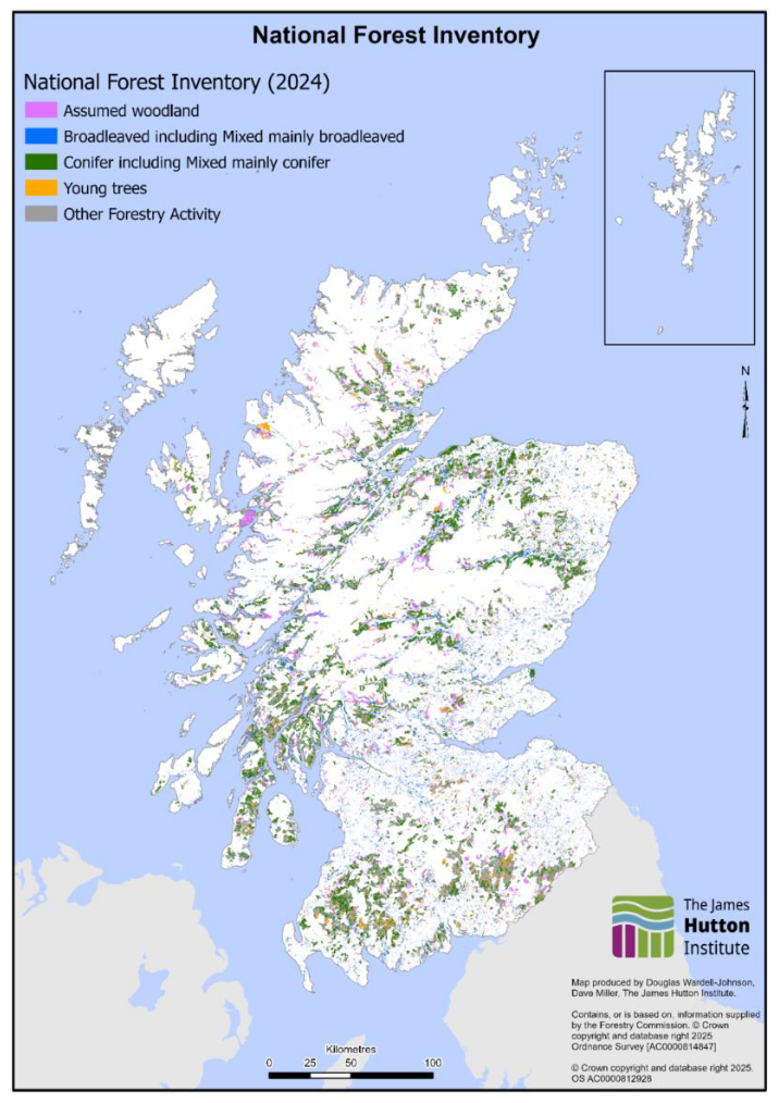
Source: National Forest Inventory Scotland 2024 | Forestry Commission Open Data website
2.2 Land Capability
2.2.1 Land Capability for Agriculture
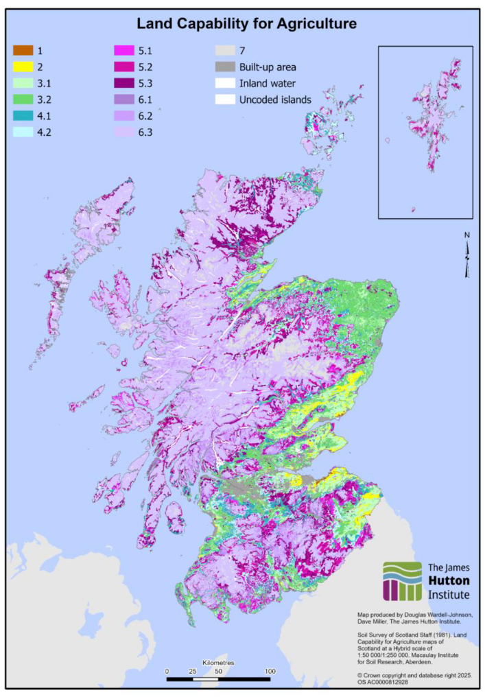
Scotland’s suitability for several key land uses, including agriculture and forestry, is limited by climatic conditions, soil quality and wetness, topography and technology. The James Hutton Institute has produced a map (Figure 5) of Scotland’s land capability for agriculture that describes the flexibility of Scotland’s land for agricultural use. Research funded through the 2022-2027 ENRA Strategic Research Programme aims to provide a revised estimate of the land capability for agriculture, in addition to projections of how it may change in response to future climate pressures.
Table 3 describes the land capability classes. Scotland has low quantities of the highest-quality agricultural land that can support a wide range of arable agriculture, with less than 6% of Scotland’s land classed between land capability 1 and 3.1 (prime agricultural land). Over 50% of Scotland’s land is land capability class 6 or 7, which has severe limitations that prevent mechanical improvement (such as subsoiling, drainage installation, or levelling land) and are thus exclusively suitable for rough grazing. Land in classes 6 and 7 is usually steep or poorly drained, has very acidic or shallow soils, and lies in wet, cool or cold areas – often in combination.
Figure 5 shows that areas of high agricultural land capability are in lowland areas of the east coast, while upland areas and the west coast have generally poorer agricultural land capability. Agricultural production is still important in upland areas, but the limited flexibility of the land constrains the choices afforded to land managers in these areas.
Despite having the natural capacity to support a narrower range of agricultural practices when compared to prime agricultural land, class 6 and 7 land still has important value. According to the 2025 June Agricultural Census, the statistical ‘Northwest’ region of Scotland (including Shetland, Orkney, Na h-Eileanan Siar and Highland local authority areas, all of which have extensive areas of class 6 land,) contains over one-third of Scotland’s agricultural holdings. Agriculture and livestock production are thus important to communities in these areas, their livelihoods and Scotland’s wider food and drink sector despite physical limitations of the land.
| Land Capability Class | What kind of agriculture can this land support? | Definition | Percent of Total Land Area |
|---|---|---|---|
| 1 | Arable Agriculture | Can produce a wide range of crops, no or very minor physical limitations | 0.05% |
| 2 | Arable Agriculture | Can produce a wide range of crops, minor physical limitations | 1.38% |
| 3.1 | Arable Agriculture | Can produce a moderate range of crops with high yields of cereals and grass | 4.32% |
| 3.2 | Mixed Agriculture | Can produce a moderate range of crops with increasing trend towards grass in rotation | 9.20% |
| 4.1 | Mixed Agriculture | Can produce a narrow range of crops, primarily grassland enterprises with short arable breaks | 4.74% |
| 4.2 | Mixed Agriculture | Primarily suited to grassland with limited potential for crops like barley, oats and forage crops | 6.06% |
| 5.1, 5.2, 5.3 | Improved Grassland | Capable of use as improved grassland. Range from 5.1 (easy to establish sward, few maintenance difficulties) to 5.3 (sward deterioration can be rapid) | 17.67% |
| 6.1, 6.2, 6.3 | Rough Grazing | Capable of only rough grazing due to intractable physical limitations. Range from 6.1 (vegetation provides high-value grazing) to 6.3 (vegetation provides low-value grazing) | 48.72% |
| 7 | Rough Grazing | Land is of limited agricultural value, and restricted to very poor rough grazing | 3.19% |
| Urban | None | Urban Areas | 2.27% |
| Water | None | Inland Water | 2.34% |
| Unclassified Land | None | Unclassified Land, Uncoded Islands | 0.06% |
Source: Land Capability for Agriculture (LCA) - James Hutton Institute
Figure 6 breaks down the land classes shown in Figure 5 by the land cover in the associated areas; land capability 6.3 is most common in Scotland, covering most of the northwest of the country, and is dominated by rough grazing. Land capability 5 and 6 collectively cover about two-thirds of Scotland’s land. Scotland’s most flexible agricultural land is located in lowland areas along the east coast. Often, land managers manage land that can vary substantially in quality. Not all of Scotland’s highest quality land for agriculture is in agricultural use.
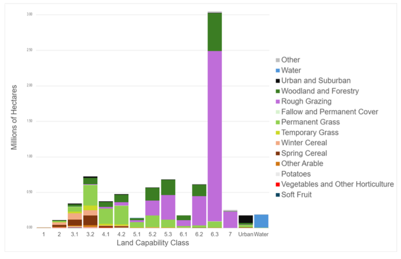
Source: Analysis produced by the James Hutton Institute, using LCA map in tandem with 2024 UKCEH land cover mapping
2.2.2 Suitability for Forestry
Forest Research publishes the ecological site classification (ESC), a decision support system that helps land managers identify which trees are ecologically suitable to particular sites. Scottish Forestry use the ESC in part to produce their climatic site suitability maps, which are used to score Forestry Grant Scheme bids based on the suitability of a tree planting proposal for a given area.
2.3 Land Uses
Scotland’s primary land uses include:
- Agriculture
- Commercial Forestry
- Nature and Land for Biodiversity
- Housing and Urban Land Use
- Renewable Energy Infrastructure
A diverse mix of land uses is required to support Scotland’s transition to a net zero, nature-positive economy.
2.3.1 Agriculture
Alongside publication of the 2023 Vision for Agriculture, RESAS published an agriculture supporting evidence and analysis pack. This pack summarises key data on agriculture that is relevant to the land sector. More information on Scottish agriculture can be found in the RESAS agricultural statistics hub, which provides summary information relating to key statistical publications across years. Data on agricultural land use is collected by the system that administers support payments to farmers. Terminology in data analysis may therefore reflect specific schemes. Section 2.5.1 explores the detail of agricultural support schemes.
Scotland’s most common land use, by land area, is agriculture, although the intensity of agricultural land use varies dramatically. Most of Scotland (86%) is designated a less favoured area[5]. Less favoured areas are defined by land that is difficult to cultivate and with limited agricultural potential which cannot be increased except at excessive cost, lower than average production compared to main indices of economic performance in agriculture, and low or dwindling populations predominantly dependent on agricultural activity. Agricultural activity is more dense in Scotland’s east and south, in contrast to the north and west.
In 2025, ~48,000 agricultural holdings submitted a June Agricultural Census return to the Scottish Government, as required under the Agriculture (Retained EU Law and Data) (Scotland) Act 2020. These holdings cover over 5 million hectares, around 64% of Scotland’s land. Around 3.9 million hectares of land, about 50% of Scotland’s land, is claimed for the Basic Payment Scheme (BPS) by around ~17,000 businesses (which can claim multiple holdings). Eligibility for the BPS means that this land is used primarily for production, covering both intensive production (e.g., arable and dairy systems) and extensive production (e.g., sheep grazing systems). In 2025 farmers in Scotland produced around ~478,000 hectares of combine harvested crops, ~1,653,000 cattle, and ~6,539,000 sheep, underscoring the importance of agricultural land use to Scotland’s food system.
Agricultural farm systems vary by geography and land capability; local climate and soil conditions influence agricultural viability across different regions of the country. Scotland’s southwest, for example, supports specialist dairy and cattle production while in contrast, general cropping and horticulture is more common on the east coast. Upland areas in Scotland are dominated by sheep grazing systems. Figure 7 explores farm types in Scotland as reported in the 2023 June Agricultural Census.
Livestock production systems underpin local agricultural economies across much of Scotland. Figure 8, based on 2022[6] June Agricultural Census data, shows the stocking rate of livestock across farming systems in Scotland, measured in livestock units (LSU)[7] per hectare. Dense livestock production occurs in the south and east of Scotland, with less favoured areas in the uplands having low levels of grazing.
Scottish agriculture is interconnected, with key commodities supporting cross-country production. Often feed grown on higher quality land in the east coast will be fed to animals on lower quality land in the west coast where animals are reared, before moving to eastern processors and markets. The symbiosis between Scotland’s livestock and arable sectors underpins the Scottish agricultural economy.
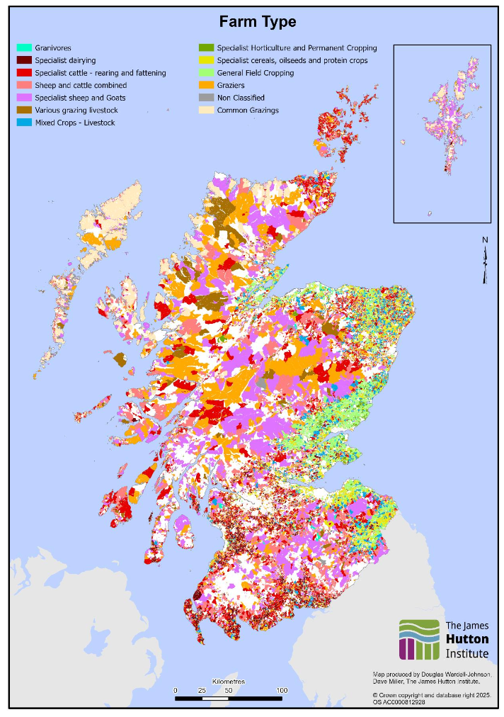
Source: 2023 Land Parcel and Census data processed by the James Hutton Institute. Data collected by Scottish Government Rural Payments and Services and RESAS through LPIS, the June Agricultural Census, and the Single Application Form.
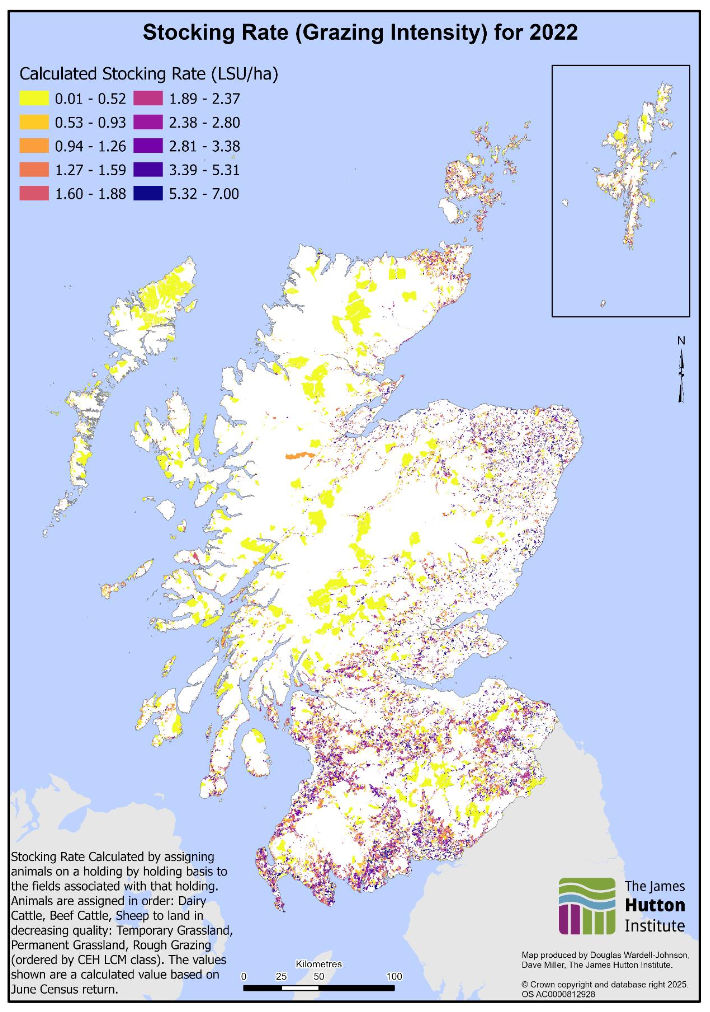
Source: 2022 Land Parcel and Census data processed by the James Hutton Institute. Data collected by Scottish Government Rural Payments and Services and RESAS through LPIS, the June Agricultural Census, and the Single Application Form.
2.3.2 Commercial Forestry
Commercial forestry activity for timber and wood products is difficult to differentiate from non-commercial forestry at a national scale – there is no one dataset that identifies woodlands as being commercial or non-commercial. No one woodland is purely commercial; all productive woodlands need to comply with the UK Forestry Standard, and as a result will have a mix of more fast-growing timber species, which are often non-native, in addition to broadleaved species and open space.
Commercial timber production is associated with conifer forests, and as such the conifer and diverse conifer category in the national forest inventory likely hold most of Scotland’s commercial forestry sites. A map of these sites is shown in section 2.1.3. Statistics on UK-wide timber production indicate that Scotland produces the majority of the UK’s softwood timber, with 6.3 million green tonnes produced in 2024. Scottish Forestry holds data on where felling licences are approved, in addition to Long Term Forest Plans, which provide some insight into commercial forestry systems.
2.3.3 Nature, Land for Biodiversity
Human land use is the biggest driver of biodiversity loss in Scotland, with the ways we grow food, harvest materials, and build urban areas all impacting the natural environment and its associated biodiversity. The State of Nature Scotland 2023 report highlights that there has been a 15% decline in average species abundance across closely monitored wildlife since 1994. In the decade to 2023, 43% of the closely monitored species declined strongly. Scotland’s natural environment has been heavily degraded over time, with continued declines across much of our land and seascapes.
Land use however also presents new opportunities to reduce the rate of biodiversity loss and increase biodiversity in Scotland. The Natural Environment Bill, recently passed by parliament, sets a duty on ministers to set legally-binding nature restoration targets, creates a power to allow amendments to the Environmental Assessment Legislation and 1994 Habitats Regulations, and modernises National Park powers and deer management.
Scotland has committed to the 30 by 30 framework, which aims to ensure at least 30% of terrestrial and marine areas are protected for nature by 2030. Over 18% of Scotland’s land area is protected specifically for biodiversity and nature through designated protected sites; including Sites of Special Scientific Interest, Special Protection Areas and Special Areas of Conservation, Ramsar sites, and National Nature Reserves. Designated areas serve several different purposes, ranging from the protection of individual species to international designations. Often, protected areas overlap with other land uses; many designated sites exist alongside agricultural land uses, for example.
Scotland also has two national parks which serve to protect and enhance Scotland’s natural and cultural heritage. Both Loch Lomond and the Trossachs and Cairngorms National Parks have roles in preserving Scotland’s land and natural environment. Both National Parks have a variety of land uses within them, with a notable mix of agriculture and forestry alongside the preservation of landscapes for nature.
Figure 9 shows where designated sites in Scotland are, and they often overlap. In certain areas of the Cairngorms, up to 9 distinct protected areas can overlap, indicating how landscapes can be managed to meet the needs of multiple species and objectives. Most of Scotland’s on-land protected areas are found in the highlands and islands, with fewer extensive areas of protected sites found along the central belt, northeast, or south.
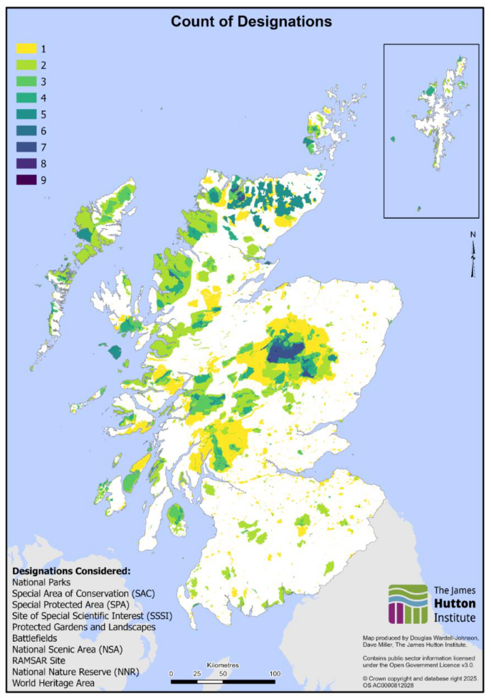
Source: Loch Lomond and Trossachs National Park, Cairngorms National Park, Special Areas of Conservation, Special Protected Areas, Sites of Special Scientific Interest, Protected Gardens and Landscapes, Battlefields, National Scenic Areas, RAMSAR Sites, National Nature Reserves, World Heritage Areas
The Scottish Rural Development Plan funds Pillar 2 payments to farmers and other land managers, which fund economic, environmental and social projects for the benefit of rural Scotland. These were historically funded under the European Union Common Agricultural Policy and subsequently transitioning to a domestic frameworks under the Agriculture and Rural Communities Bill (2023) post-Brexit. Many of these initiatives involve actions to protect and improve the natural environment. The Forestry Grant Scheme provides avenues for farmers and land managers to create new commercial and native woodlands. Ecological focus areas and hedgerows are other examples of actions that can increase on-farm biodiversity. Many arable farms are required to have at least 5% of their arable land in an ecological focus area, an area of land on which agricultural practices that are beneficial for the climate and environment are carried out. The James Hutton Institute carried out analysis in 2023 to explore the uptake of ecological focus areas, by farm type and geography; over 10,000 fields in the analysis had ecological focus areas.
Figure 10 from a James Hutton Institute analysis identifies fields where non-woodland Agri-Environment Climate Scheme (AECS) payment uptake was in 2019; across a range of farm types and geographies, farmers uptake AECS measures as part of their land management. The map shows that AECS measures have been taken up across a range of farm types and geographies, with a range of land managers and farm types benefiting from the payments. Woodland measures have been excluded from this map as these could be commercial rather than for nature benefit. Examples of AECS projects include grass strips in arable fields, away wintering of sheep, and species-rich grassland management.
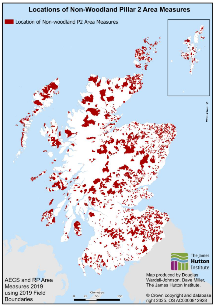
Source: 2019 Land Parcel and Scheme data processed by the James Hutton Institute. Data collected by Scottish Government Rural Payments and Services through LPIS and the Single Application Form.
2.3.4 Housing and Urban Land Use
As highlighted in section 2.1.1, less than 3% of Scotland’s land has an urban or suburban land cover, a small proportion of Scotland’s land. Scotland is a predominantly rural country with dense urban population centres; National Records of Scotland estimated that in 2020 91% of Scotland’s population lived across 2.3% of Scotland’s land area. According to analysis in the 2025 UK natural capital accounts, from 1990 to 2024 Scotland’s urban area increased from 137,289 hectares to 191,010 hectares, with most of the increase in area coming from enclosed farmland.
Scottish Government publishes quarterly housing statistics that explore the rate of new dwelling construction, with comparisons to other UK nations. National Records of Scotland indicate that Scotland has, over the 20 years from 2004 to 2024, increased the number of dwellings by 364,100, or 15%.
2.3.5 Renewable Energy Infrastructure
Scotland has over 550 active renewable energy sites recorded in the October 2025 Renewable Energy Planning Database. Renewable energy sites take up a small amount of Scotland’s land, with Scotland’s total operational solar capacity only covering 177 hectares.
Often agricultural activity can coexist with renewable energy sites, including onshore wind, where grazing activity can be supported around turbines. National Planning Framework 4 highlights that careful consideration should be given to energy development on or near sensitive habitats, including peatlands.
Most of Scotland’s operational land-based renewable energy sites, 335, are onshore wind sites, followed by hydroelectric sites and solar photovoltaics. According to Scotland’s quarterly energy statistics, Scotland’s onshore wind capacity provides the greatest contribution to Scotland’s onshore and offshore renewable energy capacity. Figure 11 shows operational renewable energy sites in Scotland as of October 2025; renewable sites are distributed across Scotland, with hubs for onshore wind energy notably in the northeast and Lanarkshire, and hydro energy sites more common in western upland areas. ‘Other’ includes categories such as biomass, hydrogen, and anaerobic digestion.
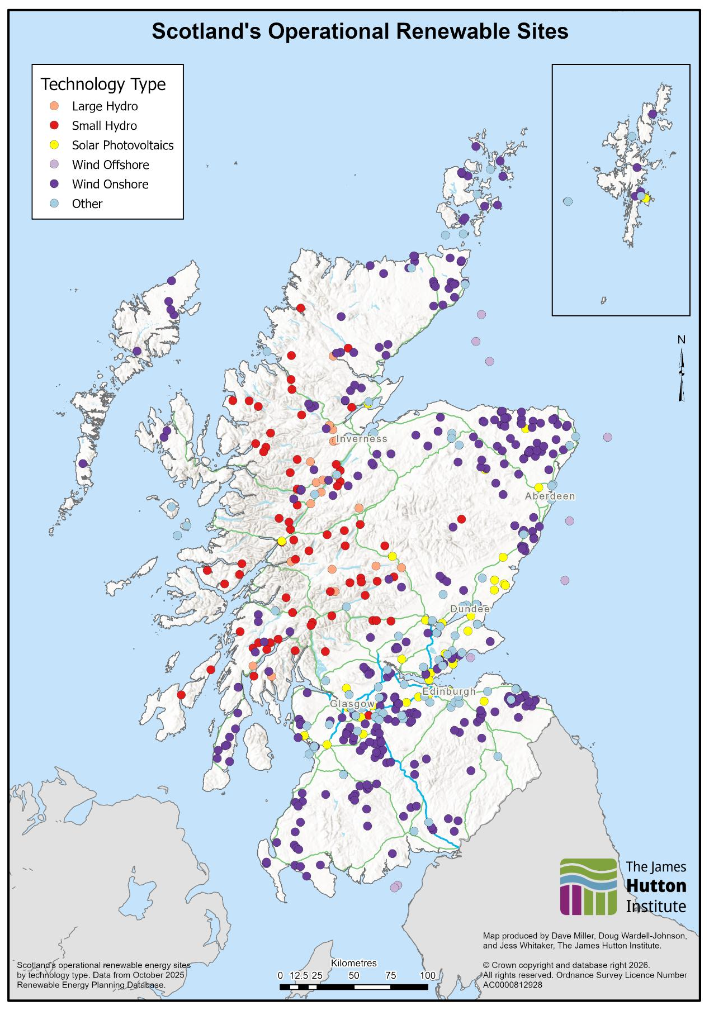
Source: Renewable Energy Planning Database Quarterly Extract
2.4 Land Ownership and Tenure
2.4.1 Agricultural Land Ownership and Tenancy
According to the 2025 June Agricultural Census (JAC), Scotland’s total area in sole occupation[9] is 5.64 million hectares. This is larger than the area of agricultural holdings referenced in section 2.3.1.1, as tenure information is pulled directly from JAC returns instead of the Single Application Form – a note on this methodological difference is explained in Note 14 of the JAC 2025 Data tables. Around 21% of the 5.64 million hectares in sole occupation, 1.2 million hectares, is estimated to be tenanted, with tenant farmers a sizable proportion of the agricultural workforce.
Figure 12 illustrates the distribution of agricultural tenancies in 2021, the last year tenancy information was collected in the JAC. Most of the agricultural land in Scotland is wholly-owned, with wholly tenanted or part-owned part-tenanted spread across multiple geographies. There is no clear geographic pattern for where tenancy or ownership is more likely. The map also shows the locations of common grazings in Scotland, which are concentrated in the northwest. Questions on agricultural tenancies were since removed from the JAC partly due to data quality concerns: around one third of the data had been imputed for over five years, and confidence was low in the remaining two thirds due to the complex nature of agricultural tenancy arrangements.
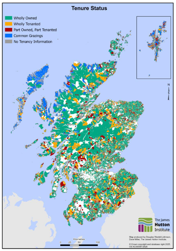
Source: 2021 Land Parcel and Census data processed by the James Hutton Institute. Data collected by Scottish Government Rural Payments and Services and RESAS through LPIS, the June Agricultural Census, and the Single Application Form.
2.4.2 Public Land Ownership
Around 857,000 hectares, or 11% of Scotland’s land, is publicly owned. There are five major public landowners: Forestry and Land Scotland, NatureScot, the Scottish Crown Estate, Scottish Water, and Crofting Agricultural Holdings. Forestry and Land Scotland is the largest public land owner, with ownership of about 8% of land in Scotland. There is also land in Scotland owned by other public owners, such as the Ministry of Defence, that are not included in the published map.
2.4.3 Community Ownership and Common Grazings
In addition to private and public ownership, as of 2024 there were ~214,000 hectares of land in community ownership in Scotland, constituted of ~850 distinct assets. Most land in community ownership is in the highlands and islands, with ~45,000 hectares in Highland local authority area, and ~154,000 hectares in Na-h Eileanan Siar.
Some of Scotland’s agricultural land is governed by common grazings, where crofters share rights to graze livestock on a common piece of land. Ownership of common grazings is mixed; some common grazings are community owned, some are publicly owned and some are privately owned, however, any owner of a croft associated with the common grazing retains rights to use the grazing land. There are over 1,000 common grazings (visualised in Figure 11) in Scotland covering an area of more than 500,000 hectares. Common grazings are most common on Skye, the northwestern Scottish mainland, Shetland, and Na-h Eileanan Siar.
2.5 Public Support for Land Management
2.5.1 Agriculture
The agriculture sector in Scotland is supported through public agricultural support payments, previously delivered under the EU Common Agricultural Policy (CAP) and now being reformed through the Agriculture and Rural Communities Bill (2023) post Brexit, which establishes Scotland’s post‑Brexit agricultural support system. Pillar 1 payments provide direct support to farmers’ incomes predominately via area based payments. The majority of Pillar 1 payments vary based on the payment regions model, with farming in Payment Region 1 (better quality agricultural land, suitable for arable cropping or improved grassland) having larger per-hectare payment values than, for example, Payment Region 3 land (rough grazing with an LFA category A classification). Pillar 1 direct payments provide a fixed rate of payment per-hectare based on how much land is actively farmed and is determined by payment region.
Pillar 2 payments, delivered through the Scottish Rural Development Programme (SRDP), fund economic, environmental and social projects throughout rural Scotland. Pillar 2 payments, unlike Pillar 1, are not a fixed per-hectare payment, but vary depending on the specific scheme, and the scope and scale of the project. Pillar 2 payments are not exclusively targeted to farmers, but various kinds of land manager. In 2025-26, Scottish Government provided over £660 million in financial support to farmers, crofters, land managers and rural communities.
Figure 13 shows the per-hectare payments to businesses across Scotland in 2022, including both Pillar 1 and Pillar 2 payments. Any business in colour received at least one of the Pillar 1 or Pillar 2 payments. Businesses with the lowest payment rates per hectare may be in receipt of Pillar 2 payments, which are generally not area based, over a large piece of land, resulting in low average payment rates. Higher payment rates per hectare are seen in lowland areas of the east coast. Highland areas have the lowest payment rates, with middling payment rates on Shetland, Na-h Eileanan Siar and the south.
On average, dairy, cattle, and arable farms in the south and east receive higher payment rates per hectare than farms in the north and west, driven by Pillar 1 payments on higher-quality agricultural land. Larger farms in the north and east may still receive more total subsidy due to their size than smaller farms with higher per-hectare payment rates in the south and east.
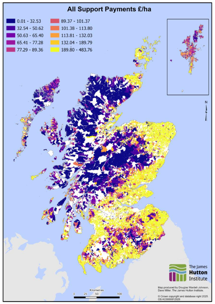
Source: 2022 Land Parcel and Scheme data processed by the James Hutton Institute. Data collected by Scottish Government Rural Payments and Services and RESAS through LPIS, the June Agricultural Census, and the Single Application Form.
2.5.2 Forestry
The Forestry Grant Scheme (FGS) supports land managers with the creation of new woodlands, and sustainable management of existing woodlands. The 2025 Scottish budget allocated £53 million for woodland grants. Figure 14 shows areas supported by awards administered via the Forestry Grant Scheme since its inception; detail on other grants awarded through Scottish Forestry can be found in Scottish Forestry’s Open Data Portal. Areas supported through a range of different FGS grants are widely distributed, with notable concentrations of projects in the central highlands, Perthshire, Argyll, and the south.
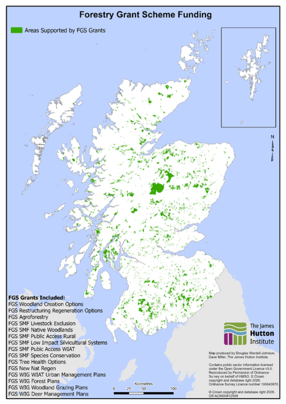
Source: Scottish Forestry Open Data Portal
2.5.3 Peatland Restoration
Peatland ACTION is the national programme offering funding to improve the condition of degraded peatlands across Scotland. Scottish Government supports on-the-ground peatland restoration activities through Peatland ACTION. The 2025 Scottish Budget allocated £35.5 million to support peatland restoration activities.
Peatland Action has, since 2012, conducted restoration activities on over 66,000 hectares of peatland; Figure 15 visualises these sites, as well as areas explored for restoration feasibility. Restoration sites are widely distributed across upland areas of Scotland, with concentrations in the highlands, southern uplands, and parts of the islands. Feasibility study sites are also widely distributed, with several large projects in the northern highlands.
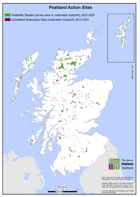
Source: NatureScot Spatial Data Hub
2.5.4 Other Public Support for Land Management
Scottish Government offers financial support for other land management actions in addition to supporting the agriculture, forestry and peat sectors. Examples of this include: the Scottish Land Fund, which offers grants to help communities take ownership of land and buildings, the Nature Restoration Fund, established in 2021, which has invested over £65 million in projects helping improve the condition of habitats across Scotland, and the Facility for Investment Ready Nature in Scotland Fund (FIRNS) grant scheme, which supports projects aiming to shape and grow private investment to finance restoration of Scotland’s nature.
2.6 Ecosystem Services Delivered by Scotland’s Land
Land use plays a critical role in delivering ecosystem services, the direct and indirect contributions ecosystems provide for human wellbeing and quality of life. In addition to provisioning services like water, food and timber, Scotland’s land provides regulating services, such as carbon storage and flood regulation, that can support adaptation to climate change. Furthermore, Scotland’s land creates cultural ecosystem services including providing places for tourism and recreation, providing a sense of place and heritage with spiritual connections, educational opportunities, and amenity and aesthetic value.
When excluding the valuation of oil and gas, the total annual value of ecosystem services in Scotland as described in the UK Natural Capital Accounts, was valued at almost £6 billion in 2022. This value was driven by provisioning ecosystem services, such as renewable electricity and water provisioning, and cultural ecosystem services, such as recreation and tourism. Oil and gas accounts for most of the total annual value of Scotland’s ecosystem services at £32.8 billion, although this value is based on volatile prices and does not reflect environmental or societal costs of oil and gas extraction.
The section will explore a small set of ecosystem services to demonstrate the value that land has in supporting key national outcomes. However, a wider set of services, some of which cannot be quantified, are also delivered by Scotland’s land; Scottish Government has produced a review consolidating Scotland’s natural capital evidence base which explores other ecosystem services in more depth.
2.6.1 Greenhouse Gases and Mitigation Potential
According to Scotland’s 2023 Greenhouse Gas Statistics, Scotland’s LULUCF (Land Use, Land Use Change and Forestry) sector is a net contributor to greenhouse gas emissions, with an estimated 0.5 MTCO2e in 2023. The forestry and grassland categories of land are net carbon sinks, with peatland, cropland, settlement, and other LULUCF categories being net sources of emissions. Avenues to reducing carbon emissions in the LULUCF sector include increasing woodland area, restoring degraded peatlands, and effective land management to prevent further degradation of peatland habitats. Figure 16 shows the breakdown in LULUCF sources and sinks in 2023.
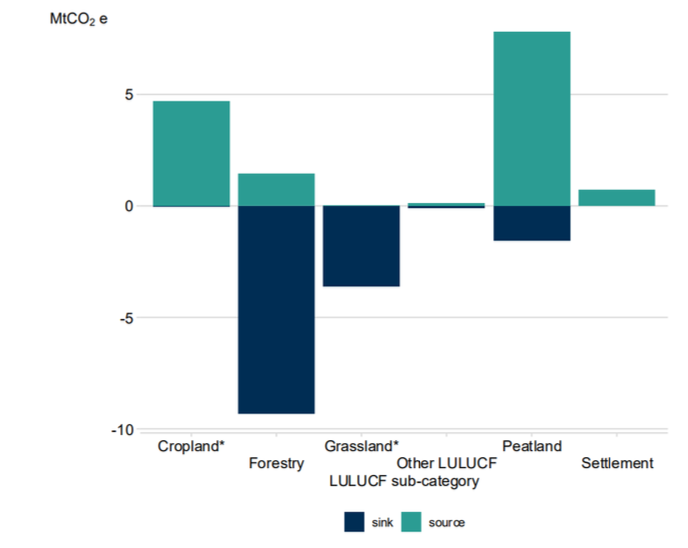
Source: Scottish Greenhouse Gas Statistics 2023
Agriculture, which is Scotland’s largest land use, contributed 7.5 MtCO2e in emissions in 2023; almost 19% of Scotland’s total greenhouse gas emissions. The majority of agricultural emissions come from methane, and as such suckler beef farms provide the largest contribution to Scotland’s agricultural emissions. There has been a long-term fall in emissions from agriculture largely driven by falling livestock numbers. Innovations in the agricultural sector and changing practices on farms can also reduce agricultural emissions. Figure 17 shows the breakdown in agricultural emissions by subsector.
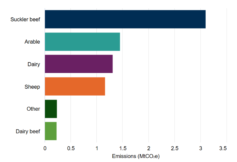
Source: Scottish agriculture greenhouse gas emissions and nitrogen use 2023-24
There is some nuance in the relationship between the agriculture and LULUCF sectors as defined in the greenhouse gas inventory. Some climate-positive changes made on farms may not reduce reported emissions from agriculture, but instead be attributed to the LULUCF sector, and thus reflected in Scotland’s overall emissions.
2.6.2 Air and Water Quality
Land use plays an important role in broader environmental quality, as both sources and sinks of pollutants that impact air and water quality. Outdoor air pollution is a large environmental risk to public health, with up to 2700 deaths per year in Scotland attributable to long-term air exposure. Transport, construction, and agricultural practices can create pollutants that directly impact human health. Poor air quality can also impact land use; the deposition of nitrogen, especially where nitrogen critical loads are exceeded, can alter vegetation communities in semi-natural and agricultural land uses.
The Scottish Air Quality website, managed by Ricardo, publishes maps of the distribution of key pollutants PM2.5, PM10 and Nitrogen Dioxide (NO2). These pollutants are mapped in highest concentrations around urban areas and, in the case of PM10, around the east and central belt. Land based actions that can improve local air quality include planting trees and creating green corridors, minimising the use of heavy machinery, and effective soil management.
The main driver of poor water quality in Scotland is rural diffuse pollution; which is where pollutants such as nutrients, sediment, faecal bacteria, pesticides and other chemicals runoff from the land into waterways. Scotland’s Environmental Protection Agency publishes regular data on water quality. Scotland’s land use can directly affect water quality; most of the water bodies in Scotland that are of less than Good Ecological status are in the central belt, northeast and southwest, driven by impacts from urban areas and intensive agriculture. Water quality is generally better in the north and north west, areas of lower urban density and more extensive land uses (although localised issues do still exist).
Figure 18 shows Scottish Environment Protection Agency’s (SEPA) 2024 estimate of national surface water status; this represents the overall ecological status of each water body, including its physical condition, water quality, ecological condition, and chemical status. Land use will partly, but not solely, impact the overall ecological status of each water body. The map shows that most rivers and surface waters in Scotland are classified as Good or Moderate. High-status waters are scattered, mainly in remote upland areas. Poor and Bad status waters are found in parts of southern Scotland and some eastern regions, reflecting areas of higher human activity and land use pressures.
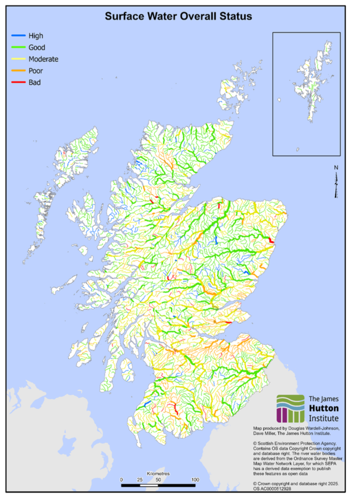
Source: SEPA Water Classification Hub
2.6.3 Water Risks – Drought, Flooding, and Wildfire
Scotland’s susceptibility to water-based risks is driven by both land-based action and broader climactic factors. Over time, Scotland’s environment is expected to change, with wetter winters, drier springs and summers, and a generally drier east coast; the annual average rainfall in the last decade (2010 to 2019) was 9% wetter than the 1961-1990 average, with winters 19% wetter. These climactic factors have implications for local water scarcity and flooding risks.
Fluvial (river) flooding presents several risks to communities, with storms likely to increase in both speed and precipitation over time as a result of warming sea temperatures. Land management practices can influence Scotland’s resilience to fluvial flooding; natural flood management (e.g. planting riparian vegetation) and maintaining and restoring wetland habitats which store water can increase resilience, while agricultural practices that limit water storage in soil (including soil compaction from intensive agriculture or poorly managed irrigation) can increase vulnerability. The Centre of Expertise for Water (CREW have published a policy brief exploring the knowns and unknowns of river flooding. SEPA publish flood risk maps that indicate how likely a local area is to experience flooding.
A CREW report from 2024 highlights that water scarcity in Scotland is generally underestimated, with a public misconception that Scotland has abundant water resources. Drought events are expected to be more common in Scotland in the future, and given climate uncertainty, adaptive strategies to water scarcity are needed. Land use actions that can reduce the risk of water scarcity include limiting large-scale afforestation in sensitive catchments, protecting and enhancing wetland habitats, including peatlands, and reducing water demand from industry and irrigation.
The Carrbridge and Dava fires in 2025 are estimated to be the largest wildfire in Scotland’s history. Wildfires thrive in areas with dry vegetation; as such, practices that serve to limit the impact of fluvial flooding and reduce water scarcity by increasing soil water content can similarly reduce wildfire risk. There are still many evidence gaps on the science of wildfire in Scotland, more work is needed to understand how current and future land uses increase or decrease wildfire risk.
2.7 Skills and Employment in the Land-based Sector
There is no formal, widely accepted definition of the land-based sector. ClimateXChange in 2023, drafted a report exploring land-based employment in Scotland. The report highlighted a range of relevant studies and estimated that hundreds of thousands of people are employed in the land-based sector, but did not come up with a single figure. Relevant data include around 67,000 working in agriculture and 12,000 in forestry. A NatureScot research report estimated that jobs in the nature-based sector, which includes agriculture, make a significant contribution to Scotland’s economy, amounting to 195,000 jobs, or 7.5% of Scotland’s workforce in 2019.
The number of employees in the rural land-based labour market, in the agriculture and forestry sectors, has increased from 2010 to 2021, mainly in predominantly rural local authority areas. In agriculture, the overall workforce is about the same, with an increase in employees offset by a decrease in working owners. Around 20% of nature-based jobs are based in cities, highlighting the importance of nature-based jobs to urban economies.
Challenges in data quality and availability make it difficult to specify exactly how large the land-based workforce is in Scotland. There are several challenges for employers in rural areas, particularly those tied to recruitment, retention and labour shortages.
A Scottish Government report from March 2025 highlights that there are several skill gaps in the land-based labour market. The evidence highlighted that verbal communication and team work are key transferrable skills gaps across sectors. The report also found that while some technical skills are transferrable, moving to a new environment or industry requires new training, limiting the ease of knowledge transfer. Enhancing transferrable skills of workers can foster networking opportunities and income diversification, however, there are several barriers to this, including limited capacity for upskilling, the location of training courses, and mindset challenges.
In line with the broader set of land‑based sectors defined by the Commission to Review Land-Based Learning – covering agriculture, aquaculture, biodiversity, environmental conservation, equine, forestry, trees and timber, food and drink processing, game and wildlife, horticulture, land-based engineering and peatland restoration – recent evidence from the Rural Delivery Plan, SDS Sectoral Skills Assessments and the Rural Business Panel Survey highlights persistent skills shortages across rural industries. These include gaps in digital capability, business management, and technical competencies needed for low‑carbon land management and nature restoration.
A NatureScot report from 2025 highlights that apprenticeship pathways are a key avenue for addressing skills gaps in rural skills, and game and wildlife management. However, some businesses, particularly small rural and island businesses, struggle to engage with apprenticeship products due to capacity, time and resource constraints. The report also highlights that, given 83% of ‘rural’ Scotland is privately owned, stronger partnerships are needed to engage private landowners in skills development.
2.8 Integrated Land Use
Integrated land use is defined in the Land Use Strategy as taking a holistic approach by combining two or more activities on the same area in a way that enhances the overall benefits. For Scotland, where land is a finite resource, this approach is key to meeting climate targets, improving biodiversity, and sustaining rural economies.
By delivering synergies and win-wins, integrated land use presents an opportunity to deliver more than one positive outcome on a given area of land. A Royal Society report on multifunctional landscapes highlights that navigating the growth of larger wealthier populations, mitigating climate change, and improving resilience in the face of extreme weather make using land in ways to support multiple outcomes increasingly essential.
Defining the scale at which integration could happen is critical; there are numerous examples of how integrating multiple land uses at a field or farm scale can yield benefits, but less evidence exists on the benefits of catchment, regional, or national approaches to integration. Current research into integrated land use at local scale highlights that a diversity of land uses on the same field can enhance overall output. On farms, wetland and peatland restoration can improve water management, planting wildflower strips can increase pollinator visits and subsequently crop yields, and shelterbelts can both protect livestock from climactic extremes and reduce soil erosion.
Evidence exploring integrated land use at landscape-scale is limited, primarily due to a lack of case studies exploring integrated land use over landscapes and the definitions of both integrated land use and landscape in a research context. However, it is widely recognised that increasing the diversity, and biodiversity, of a landscape at larger-scale can deliver wider benefits, including to flood management and preventing the spread of animal and plant disease. Additionally, it is clear that landscape-scale thinking and collaboration can deliver increased benefits on a sector-by-sector basis; nature networks and corridors being a key example of how coordinated action at landscape-scale between land managers can increase nature benefits.
Integrating additional land uses to an existing enterprise can diversify and increase the resilience of land manager incomes. Particularly for farming, which can be subject to volatile and seasonal markets, diversification is becoming increasingly attractive by presenting a way to increase the resilience of farm businesses.
According to the Farm Business Survey, farms with diversified activity, defined as non-agricultural work of an entrepreneurial nature carried out on or off-farm which makes use of existing farm resources (excluding agricultural work on another farm) in Scotland consistently have higher farm business incomes than farms without any diversification. Diversification in this context could include activities like tourism, renewable energy, or letting buildings. Currently, it is difficult to know if the resilience of these farm businesses comes from increased diversification versus other innovation or management measures.
Looking ahead, integrated approaches, such as incorporating nature-based solutions or accessing natural capital finance, could provide new opportunities for diversification. Tenant land managers and crofters may struggle more than owner-occupiers to access diversification opportunities due to landlord consent requirements.
2.9 Where Could Land Use Opportunities Overlap? – Landscape Zonation Research
In practice, land managers have a diversity of options when it comes to how their land is used. The same land may have the capability to fulfil multiple possible land uses. There may also be a range of sources of funding available to the land manager seeking to make a good living from the land.
The maps presented in this section are based on academic research produced by the James Hutton Institute, and are included to highlight that Scotland’s land can support multiple activities, based on local landscape potential. These maps are not prescriptive options for how Scotland’s land should be used, or indicative of Scottish Government’s policy intent.
Figures 19, 20, 21 and 22 have been produced alongside a report delivered through the large scale modelling topic in the 2022-2207 ENRA Strategic Research Programme . In the report, which was designed in consideration of the Scottish Biodiversity Strategy, the creation of new woodlands and agroforestry were modelled conditionally based on both exclusion and positive targeting criteria addressing biodiversity, water, agriculture and climate change.
New woodlands were modelled with several environmental and policy criteria, including the desire to avoid planting new woodlands in areas of productive arable land; while planting on productive arable land would enable trees to grow quickly, planting on higher quality agricultural land is not supported due to the policy aim of ensuring there is sufficient land in Scotland for food production. New agroforestry was considered on arable land and grassland. The table below describes which land cover classes were considered when evaluating the woodland and agroforestry criteria. Further Information on the criteria used for each of the underpinning datasets can be found in the above report.
| Land Cover Class | Land Considered for New Woodlands | Land Considered for New Agroforestry |
|---|---|---|
| Arable and Horticulture | No | Yes |
| Improved Grassland | Yes | Yes |
| Neutral or Acid Grassland | Yes | Yes |
| Heather or Heather Grassland | Yes | No |
Figure 19 compares where areas of new woodland potential are in contrast to peatland restoration potential. The map indicates that areas suitable for new woodland and areas suitable for peatland restoration are mutually exclusive; these land uses are not compatible on the same land. While Scotland’s land can in places support a mix of uses, peatland areas cannot support new woodland planting as growing trees on peat disturbs the peat, increasing emissions. This constrains where new woodlands can be planted. Areas suitable for peatland restoration are found in upland areas and the islands, while areas suitable for new woodland potential are more concentrated in lowland areas. Woodland planting and peatland restoration are not the only land use options possible in the mapped areas.
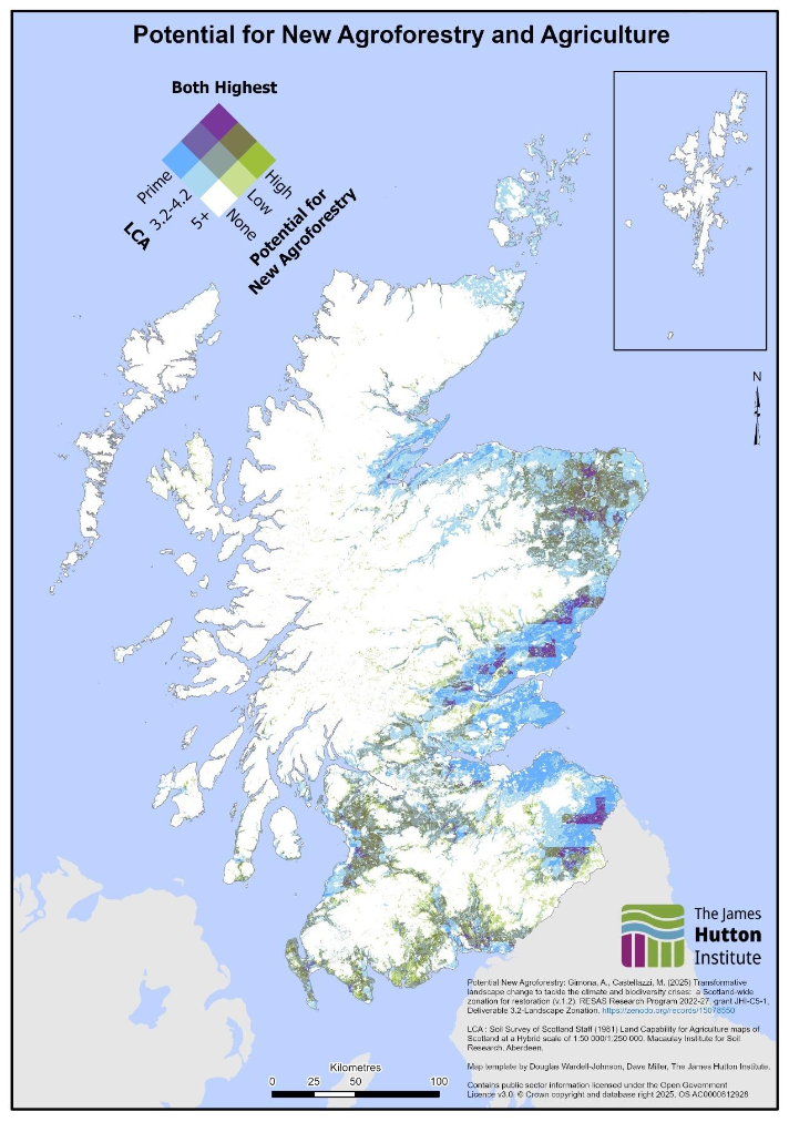
Figure 20 compares where areas of new woodland potential are in contrast to the quality of agricultural land. The map indicates that grassland areas in the southwest and northeast have high potential for new woodland creation on land of middling agricultural quality. The northeast of Scotland has a notable diversity of potential, ranging from prime land exclusively suitable for agriculture to middling agricultural land that also has high potential for woodland creation. Upland areas are typically low agricultural land quality, with similarly low woodland creation potential. Woodland planting and agriculture are not the only land use options possible in the mapped areas.
Figure 21 compares where areas suitable for new agroforestry are in contrast to agricultural land capability. Similarly to Figure 20, prime opportunities for agroforestry and high capability agricultural land exist in the northeast, Tayside and the borders, with limited land capability for either agriculture or agroforestry in upland areas. Transitional areas between upland and lowland regions have mixed potential for both agriculture and agroforestry. The perceived ‘blockiness’ of the agroforestry data comes from a 2-kilometre buffer zone created around arable conservation areas where tree planting would be unsuitable. Agroforestry and agriculture are not the only land use options possible in the mapped areas.
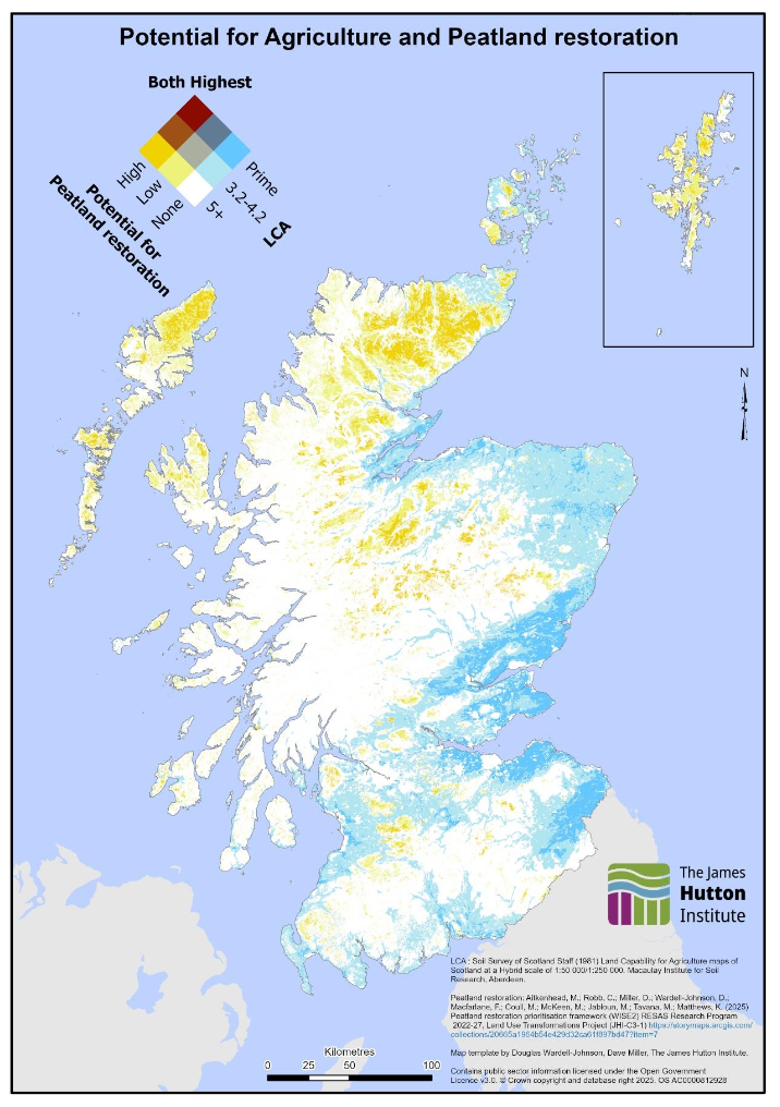
Figure 22 compares where peatland restoration potential is in relation to agricultural land capability. Prime areas for peatland restoration and higher capability agricultural land are mutually exclusive; peatland restoration targets exist almost entirely on LCA 5+ land in upland areas. Large areas of the eastern and southern lowlands have prime or moderate‑quality agricultural land with little or no peatland available for restoration. Areas of prime and moderate agricultural land do not overlap with areas most suitable for peatland restoration. The map may not show all places where agricultural land use exists over degraded peatland; it is possible that some prime agricultural land in the north of Scotland may overlap with degraded peatland, and therefore be a prime target for restoration due to the relatively high emission factors for grassland peat, however challenges with peat data quality make this difficult to say with any certainty. Peatland restoration and agriculture are not the only land use options possible in the mapped areas.
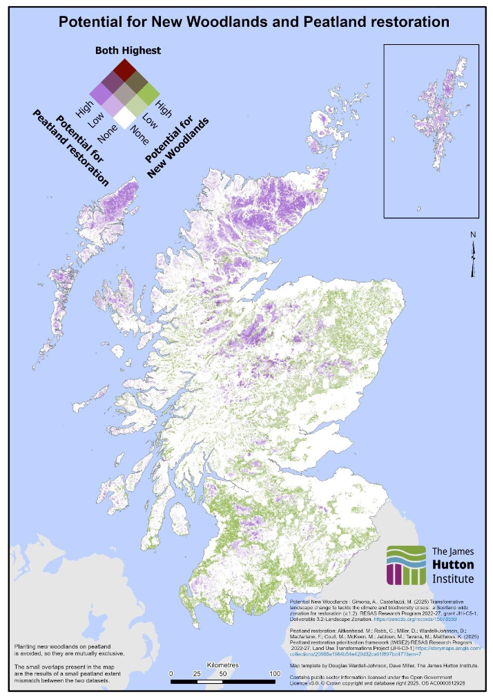
Source: Transformative landscape change to tackle the climate and biodiversity crises: a Scotland-wide zonation for restoration, Peatland restoration prioritisation framework (WISE2)
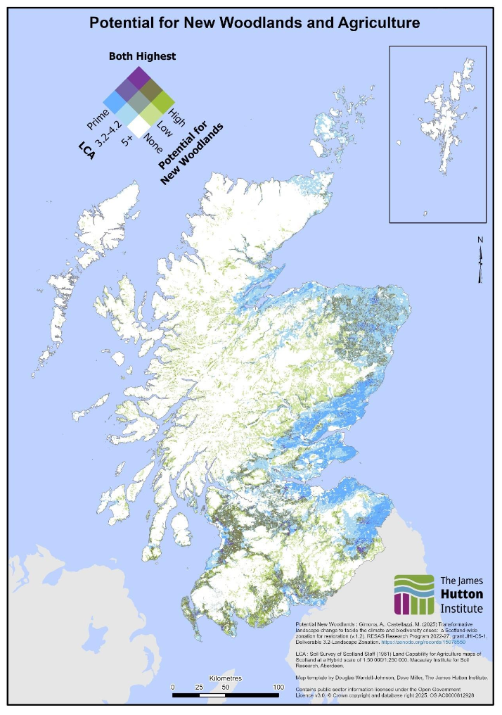
Source: Transformative landscape change to tackle the climate and biodiversity crises: a Scotland-wide zonation for restoration, Land Capability for Agriculture
Source: Transformative landscape change to tackle the climate and biodiversity crises: a Scotland-wide zonation for restoration, Land Capability for Agriculture
Source: Land Capability for Agriculture, Peatland restoration prioritisation framework (WISE2)
The selected maps highlight the place-based nature of Scotland’s land use decision making; actions suitable on one landscape may not suit another, or may be complementary in the same landscape. While modelling can help explore strategic options for land management, in practice where land is privately owned land can be turned over to a wide range of uses outside of natural or agricultural ecosystem services, including housing or energy production where returns may be greater.
2.10 Rural and Island Communities
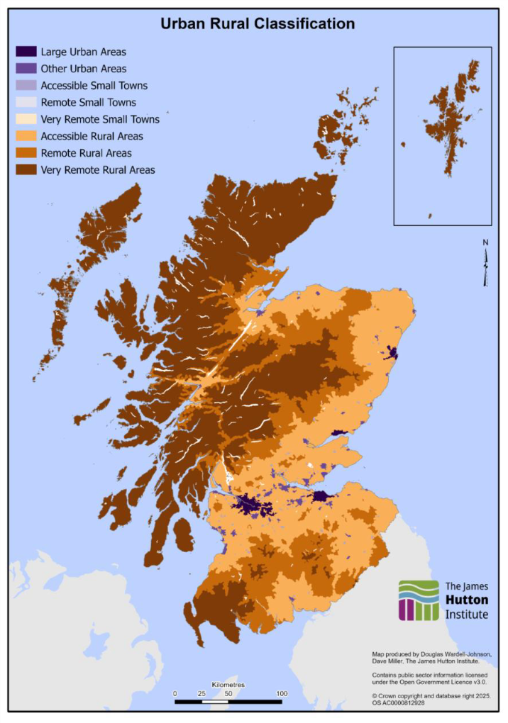
Almost 40% of Scotland is considered to be a very remote rural area (defined as areas with a population of less than 3,000 people, and with a drive time of over 60 minutes to a settlement of 10,000 or more) based on the Scottish Government Urban Rural Classification 2022 . In total, rural areas comprise 98% of Scotland’s land area based on the land area tables in the 2022 publication.
Figure 23 shows the 8-fold Scottish Government Urban Rural Classification 2022, with the highlands and islands making up the majority of Scotland’s very remote rural areas. The areas surrounding Scotland’s major urban areas (Glasgow, Edinburgh, Dundee, and Aberdeen) are predominantly classed as accessible rural areas interspersed with smaller urban or suburban areas. The areas directly surrounding Dumfries, Fort William, and Inverness, which would otherwise be classed as remote rural, are also marked as accessible given their access to a larger population centre.
Rural and island communities face unique challenges, including access to services, affordable housing, and fuel and energy costs. The Rural Scotland Data Dashboard provides data on a range of issues that impact rural Scotland. The Scottish Islands Data Dashboard provides additional data on a range of metrics specific to Scotland’s Islands.
Source: Scottish Government Urban Rural Classification 2022 - gov.scot
2.11 Future Data and Analysis Opportunities
2.11.1 Gaps in Existing Evidence
Despite having data on a range of important land uses in Scotland, there are gaps in some land-based data and, subsequently, gaps in how effectively land uses can be monitored to deliver national outcomes. Some of these limitations include:
- Habitat Quality
- While multiple different datasets can provide detail on Scottish habitats, assessing the quality of those habitats is often assessed at a site-level, and so developing a national picture of habitat quality is difficult.
- Biodiversity
- Scotland does not have a standard way to map biodiversity. It is difficult to know how changing land uses can ultimately drive measurable biodiversity change and ecological health.
- Soil Health
- Although soil data exist, there is limited coordinated data collection and assessment on key soil health indicators such as organic matter, structure, and biological activity. These are critical for climate and agricultural resilience.
- There is no unified dataset on forthcoming planning applications (housing, infrastructure etc), energy consents, or land-use change intentions.
- It is not easily accessible or sufficiently detailed to identify who makes land-use decisions.
- Grazing deer can have a substantial impact on woodlands and peatlands. Existing deer data is incomplete and of poor quality, limiting understanding of their impact on natural regeneration and ecosystem health.
- Scotland lacks a consistent approach to mapping natural capital at spatial scales that support policy and investment decisions. However, there ongoing work on this within the ENRA Research Programme and with the NatureScot Natural Capital Tool.
- Centralised Data Structures and Open Access
- Some data on land in Scotland is held behind a paywall, is not regularly published, or is published at a scale that makes join-up with other data difficult. Resolving some of these data barriers and increasing open access to data could enhance applications of data on land to solve problems.
- Planning
- There is no unified dataset on forthcoming planning applications (housing, infrastructure etc), energy consents, or land-use change intentions.
- Land Ownership and Decision-Making
- It is not easily accessible or sufficiently detailed to identify who makes land-use decisions.
- Deer Populations
- Grazing deer can have a substantial impact on woodlands and peatlands. Existing deer data is incomplete and of poor quality, limiting understanding of their impact on natural regeneration and ecosystem health.
- Natural Capital
- Scotland lacks a consistent approach to mapping natural capital at spatial scales that support policy and investment decisions. However, 57 Land Use Strategy there ongoing work on this within the ENRA Research Programme and with the NatureScot Natural Capital Tool.
- Centralised Data Structures and Open Access
- Some data on land in Scotland is held behind a paywall, is not regularly published, or is published at a scale that makes join-up with other data difficult. Resolving some of these data barriers and increasing open access to data could enhance applications of data on land to solve problems.
2.12 Ongoing and Upcoming Research
Looking forward, there are several opportunities to expand our understanding of land and land use in Scotland. These opportunities include:
- Scotland’s Land LiDAR Programme
- The Scottish Land LiDAR (Light Detection and Ranging) Programme aims to deliver the first ever full LiDAR map of Scotland. It will deliver geospatial information products derived from high-resolution LiDAR data collected from spring 2025, and a full Scotland map available in 2027. This will generate highly detailed 3D maps of Scotland, offering unprecedented insight into land structures and landscapes. If applied effectively, this data can be transformative for evaluating Scotland’s land uses. LiDAR will improve our understanding of terrain, vegetation, and hydrology, supporting better land management, carbon accounting, and climate resilience planning. It will also help identify opportunities for habitat restoration and biodiversity enhancement, providing a robust evidence base for policy and decision-making.
- This programme is support by research projects, undertaken in 2025-2027, to build the tools to use LiDAR in different contexts and to showcase how it can address specific policy and delivery challenges. The key themes of the research are: geomorphology/hydrology, forestry/vegetation, agriculture and developing a ‘resilience index’.
- Data will be openly available on the Scottish Government Remote Sensing Portal, whereby historical datasets of LiDAR scans over various areas of Scotland have previously been undertaken.
- The Scottish Government is also commissioning a series of coastal LiDAR surveys in 2025/26, which can support the land LiDAR programme.
- The 2027-2032 ENRA Research Programme
- This programme, which currently funds £45 million of research annually, aims in its next iteration to build on Areas of Research Interest that will shape future missions and challenges. These missions will address complex environmental and natural resource questions, with land use recognised as a cross-cutting theme influencing climate, biodiversity, and rural economies. To support this, the programme is expected to explore approaches such as the Decision Support Strategy, which seeks to improve integration of data, models, and tools for policy use, and provide collaborative spaces for testing and refining solutions in real-world contexts. Together, these approaches could help bridge evidence gaps and enable adaptive, system-wide responses to Scotland’s environmental challenges.
- Maximising the potential of cross-UK research partnerships, such as the Land Use for Net Zero (LUNZ) Hub
- The LUNZ Hub has been successful in driving novel research projects with cross-UK impact that have applications in a Scottish context. Continuing engagement with LUNZ Hub has the potential to generate new insights for maximizing potential from Scotland’s land. The LUNZ Hub has funded and is already delivering 5 long-term research projects, all of which have relevance to Scottish land and land use.
- The MACC Hub, focused on climate adaptation and resilience, also provides an opportunity for the creation and dissemination of cross-UK evidence on land use, with a focus on building skills and partnerships, generating data and knowledge, linking knowledge policy and practice, and innovating through funding.
- Publishing Statistics on Peatland
- In publication of the Peatland ACTION five year partnership plan 2025-2030, Scottish Government committed to the regular publication of peatland statistics, covering peatland extent, quality and restoration. This will enable greater exploration of the uncertainty associated with peatland data, and provide an avenue for monitoring and evaluation of peatlands in the long-term.
Contact
Email: lus4@gov.scot