Economic Report on Scottish Agriculture 2011 Edition
Invalid description field:Agriculture
Part of
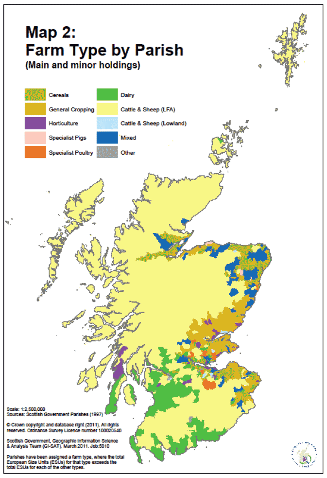
Overview of farm types in Scotland (Map 2 Table C1)
Using results from the June Agricultural Census, holdings are classified into several farm types, which are allocated if the relative contribution of a specific farming activity accounts for at least two and thirds of a holding's total Standard Gross Margin ( SGM) value. There are ten farm types (cereals, general cropping, horticulture, specialist pigs, specialist poultry, dairy, LFA cattle and sheep, lowland cattle and sheep, mixed and other). The geographic distribution of these farm types is presented in Map 2. It should be noted that this map shows a generalised view by parish rather than by holding, with a parish being allocated a farm type if the SGM total within the parish for that type exceeds the total SGM for each of the other types. We have also included the 'Specialist grass and forage' farm type in Table C1 as it relates to a large number of holdings, although this farm type does not feature much in Map 2 as this activity has a relatively low SGM value.
Upland areas
Map 2 shows the vast majority of Scotland's agricultural area is covered by LFA (Less Favoured Areas) cattle and sheep holdings. These are mostly located in upland areas of the Highlands and Islands, Orkney, Shetland, western Tayside, southern Ayrshire and parts of Argyll & Bute, East Central, Scottish Borders and Dumfries and Galloway.
Lowland areas
Dairy livestock holdings are mostly located in lowland areas such as Dumfries and Galloway, North Ayrshire, the Clyde Valley and parts of Argyll & Bute, East Central and Fife.
Areas specialising in cereal crops are mostly located to the east of the country in places such as Grampian, Scottish Borders, Lothian as well as parts of East Central and Fife. There also tends to be a higher concentration of general cropping holdings in Tayside and Fife and parts of the Scottish Borders, Lothian and the North East.
Smaller holdings that make up farm types such as horticulture, specialist pigs and specialist poultry are not represented clearly on the map due to the small area they make up. These holdings are dispersed around lowland areas while mixed farming areas tend to be concentrated in the North East, the Scottish Borders, Lothian and East Central.