Scottish National Adaptation Plan: annual report 2025 to 2026
The annual progress report setting out the delivery record over the past 12 months of the Scottish National Adaptation Plan relating to climate change.
Nature Connects (NC)
SNAP3 Outcome: Nature connects across our land, settlements, coasts and seas.
This section presents policy delivery progress against the SNAP3 Nature Connects outcome. Climate adaptation and resilience sits in the centre of joint efforts to address the climate and nature emergencies. A nature positive Scotland is one of the best tools we have to help our communities, places and businesses adapt to the changing climate.
The Nature Connects (NC) chapter in SNAP3 focuses on six delivery objectives that use nature to build climate resilience across Scotland.
The Scottish Government continues to strengthen alignment across key policy areas, building on the shared commitments set out in the Scottish National Adaptation Plan (SNAP3) and the Scottish Biodiversity Strategy (SBS) Delivery Plan and recognising that those policies and actions will contribute to outcomes that support both biodiversity and climate adaptation. During the reporting period the Natural Environment (Scotland) Act 2026 came into effect, setting out the duty for Scottish Ministers to set targets for improving biodiversity. Once finalised, these targets will help to drive actions set out in both the SBS Delivery Plan and SNAP3.
Objectives
NC1 – Nature based solutions
Nature-based solutions (NBS) are protected, enhanced and connected to enable healthier, cooler, water resilient and nature-rich places.
Nature-based solutions (NBS) delivered through examples like street trees, more urban parks, raingardens, green roofs, improved walking, wheeling and cycling and water ways all build climate resilience. Water resource planning to support drought and flooding resilience, improve water quality and quantity, and protect biodiversity is a key part of improving NBS. Blue-Green infrastructure can tackle local climate risks such as absorbing increased surface water flooding after heavy rainfall events, whilst provide benefits for people and the natural environment.
During the reporting period progress has been made to implement NBS across Scotland:
- The Nature Restoration Fund continues to play a transformative role in delivering NBS and natural management approaches across Scotland.
- In 2025-26, 13 projects[3] received a share of £5m to tackle non-native invasive species, retore riverways and help conserve wildcats, polecats, and native plants.
- Over £75 million has been invested to date, creating new and improved habitats, expanding pollinator networks, enabling fish migration into our rivers, and restoring riverside trees that cool rivers, improve water quality and hold upstream rainwaters. These locally delivered projects make a difference to local communities as well as benefiting nature, now and in the future. An interim evaluation of the Nature Restoration Fund[4] (August 2025) found that projects have delivered;
- 15,427 hectares of habitat under active restoration
- 216 km of linear habitat protected from invasive species
- 328,813 trees planted and 68.3 km of hedgerows created
- More than 282 hectares of habitat for pollinators restored or created
- Improved local access and connectivity to the natural environment.
The Fund has made it possible for a wider range of organisations to engage with nature restoration and for new technical skills to be developed within communities, contractor networks, and local authority teams – supporting Scotland’s long-term ability to adapt to our changing climate through nature restoration.
- The Scottish Marine Environmental Enhancement Fund (SMEEF) enables NBS and nature restoration projects in the marine and coastal environment. The most recent SMEEF Impact Report[5] (June 2025) includes information on projects supported by new funding initiatives, as well as existing projects around Scotland’s coastline and seas. Two new initiatives are supporting the climate resilience of people and nature along our coastlines and in our seas:
- The Seagrass Meadows Scotland initiative, in partnership with Scottish & Southern Energy Networks Distribution (SSEND), will see £2.4 million distributed to plant 14 hectares of seagrass over the next three years, supporting both nature and coastal communities around Scotland;
- Seabird Resilience Fund, ‘Taking Flight’, has been established with the support of voluntary contributions from offshore renewable energy developers in the Northeast and East Ornithology Group in 2025, to explore and address the risks and challenges faced by seabirds in Scotland.
- Continued peatland restoration (through Peatland ACTION);
- Ongoing assessment of the risks associated with arrival of non-native pink salmon, and;
- Use of SEPA’s Sea Lice Risk Assessment.
- The Wild Salmon Strategy Implementation Plan, 2nd Annual Progress Report[6] (May 2025) sets out that through Scotland’s River Basin Management Plans to date, the removal and easing of barriers to fish migration has opened 1400 kilometres of previously inaccessible habitat to migrating fish populations. SEPA also undertook over 600 farm compliance visits to tackle diffuse pollution. Improved and resilient habitats for migrating fish across Scotland have been enabled through;
- Riparian tree planting;
- Continued peatland restoration (through Peatland ACTION);
- Ongoing assessment of the risks associated with arrival of non-native pink salmon, and;
- Use of SEPA’s Sea Lice Risk Assessment.
The third year of implementation will continue to focus on delivery, measuring ecological impact, ensuring sustainable resourcing, continuing to work collaboratively and building on existing momentum to ensure that along our rivers, waterways and catchments, adaptive action is taken in the right places to support migrating fish.
- As our climate changes so flood resilience becomes increasingly important to our communities and businesses. The Water Environment Fund (WEF) supports restoration of our waterways, helping to improve water quality and river condition for migrating fish and contributing to the outcomes of River Basin Management Plans (RBMP). The WEF also contributes to the restoration and enhancement of wetland habitats and the creation of nature-rich active travel routes. It supports communities to manage local flooding risks, contributing to objective C3 - community resilience. In the reporting period £5 million was provided to around 40 projects, including;
- Completion of work to restore the Back Burn, Fife. Constructing ‘rock ramps’ to improve fish migration; improving access for the local community through new footpaths, boardwalks and footbridges; planting around 100 new trees to store carbon, improve water quality and enhance wildlife;
- Landscape scale restoration along the Nith, New Cumnock. Reconnecting a local floodplain with the river for the first time in living memory has reduced farmland flood risk and created new wetland habitat. This brings increased resilience to both the local community and local wildlife.
- Urban river restoration of Burdiehouse Burn, Edinburgh. Initial planning to uncover and re-route parts of the river which flows from the Pentlands to Portobello. Bringing local resilience by creating new access pathways and active travel routes; using NBS to connect habitats, cool the riverway, improve water quality and better manage more frequent rainfall and local flooding.
- Recently published research[7] has identified that, under current UK Climate Projection scenarios, where nature-based measures are not taken, there are increasing multiple costs including to soil quality, declining water quality, storm damage and deer overpopulation. All of this is already impacting public budgets, supply chains, and community resilience. To be fully effective NBS that help us mitigate and adapt to our changing climate need to be implemented at a scale and in places that are locally important. They also need to be delivered in an integrated manner across a whole landscape and/or catchment. Such research is helping to inform approaches for delivering landscape scale adaptation (see Outcome NC2).
NC2 – Landscape scale solutions
Landscape scale solutions are implemented for sustainable and collaborative land use, including protecting and enhancing Scotland’s soils.
Whilst individual projects funded through the public grant monies are delivering solutions for local climate adaptation and nature restoration, the biggest transformations will be made by working at landscape scale. River catchments offer an opportunity to address climate risks affecting places and people from river source to our coastline and into the sea, addressing multiple issues in a co-ordinated way.
Increasingly, collaborative approaches are being developed to prioritise action and investment in natural water management, to address issues such as flooding, drought, river cooling, water quality and habitat loss through shared resources.
Progress on landscape scale solutions for climate adaptation in this reporting period includes:
- A public service reform approach led by NatureScot to identify shared catchment priorities across Scottish Water, SEPA, Scottish Forestry and Forestry and Land Scotland. Research published by the John Hutton Institute and Verture[8] (March 2025) proposed seventeen catchments and 4 sub-catchments as priority areas for nature restoration. The research is informing:
- ongoing prioritisation of existing landscape / catchment scale projects;
- gap analysis for new projects where the agencies need to work together;
- a prioritised pipeline of projects out to 2045.
This is an important area of focus for future years which feeds into Scottish Government priorities to deliver:
- Updated River Basin Management Plans (RBMP);
- Landscape Scale exemplar projects for nature restoration delivered through the SBS Delivery Plan;
- Public service reform for efficient resourcing in delivering catchment restoration that brings benefits to communities and to nature.
- River Basin Management Plans (RBMP’s) aim to improve the quality and condition of Scotland’s rivers. Collaborative river management approaches are being taken by farming clusters to address shared climate-risks which impact upon their businesses. This includes flooding, drought and poor soil condition affecting land and waterways that they manage. Two such clusters are:
- The Wetland Connectivity Project delivered by 7 farmers within the Highlands, Well Ness Farm cluster has delivered 26 new ponds, re-meandered 1000m of watercourses and restored a large marsh, allowing wildlife migration across the wetland area.
- Farmers in the Moray Firth area coming together to create nature-rich, connected habitats that can hold water for longer and result in improved soil quality, as well as providing new spaces for ground nesting birds, waders and great-crested newts.
Catchment scale, partnership and collaborative approaches will become increasingly important within new RBMP’s to be implemented 2027-2032.
- Soils underpin all of our sectors, across rural and urban areas. To achieve a vision of “Thriving soils for Scotland’s communities, economy and environment”, leadership is needed across multiple policy areas. A ClimateXChange Fellow convened cross-policy and cross-sectoral co-operation to develop a Soil Route Map for Scotland[9] (May 2025) that addresses the challenges and risks to soil health across Scotland. The Fellow has continued to work with Scottish Government policy teams and sector experts to develop refined actions for protecting, restoring and enhancing soils. Future work will include updating the Scottish Soil Framework 2009.
- Scotland's fourth Land Use Strategy[10] (March 2026) sets out our strategic direction towards national scale integrated land use and describes how integrated land use will build greater resilience to the impacts of climate change, and support delivery of Scotland’s climate and nature ambitions.
- We are continuing to support Regional Land Use Partnerships (RLUPs) to help strengthen our communities and contribute to a fairer and greener economy. By consolidating and building on learning from their previous work, RLUPs are identifying regional priorities and opportunities that align with national ambitions for land, nature and climate. The South of Scotland RLUP has developed the initial stages of a climate resilience and nature recovery project in the Lyne Water, near Peebles. The Tweed Forum brought together landowners, land managers and communities in the catchment, to explore opportunities for nature-based solutions that address flooding, drought and to develop a local nature network. Local expertise is informing a catchment-scale proposal for multi-functional land use and integrated, resilient, nature-positive landscapes.
- To support a just transition and make sure that no one is left behind as we move to a net zero, climate resilient, nature positive Scotland we consulted on a draft Land Use and Agriculture Just Transition Plan[11] (August 2025). This focused on the livelihoods, skills, health, and wellbeing of those who live in and rely on Scotland’s land and agricultural sector, as well as on maintaining and supporting thriving rural and island communities. Responses are available to view on the Citizen Space online platform. Feedback from the consultation, and insights from a separate Consultation Analysis Report[12] are being used to develop the final version of the Land use and Agriculture Just Transition Plan, for publication later in 2026. The insights will also be an important part of co-developing future Just Transition work undertaken within the next Parliamentary period, to make sure that no one is left behind in our transition to a net zero, nature positive, climate resilient nation.
NC3 – Development planning
Development planning (including Local Development Plans and associated delivery programmes) takes current and future climate risks into account and is a key lever in enabling places to adapt.
Our fourth national Planning Framework (NPF4) sets out relevant policies to encourage, promote and facilitate development that addresses the global climate emergency and nature crisis. Through these policies, and other regional and local strategies (e.g. Open Space Strategies, Coastal Climate Change Adaptation Plans, Water Management Plans, etc.) planning authorities are developing their spatial framework to guide decision-making that will support the delivery of a wide range of strategic priorities.
During the reporting period:
- The Scottish Government continued to support all local authorities, through the National Planning Hub, in their preparation of new Local Development Plans. (LDPs). These help local decision-makers by showing the spatial implications of national policy for their area, including NPF4 policies on climate change mitigation, adaptation and biodiversity loss. LDP preparation is a staged process; all Local Authorities have now started preparation of their new style LDPs with a majority expecting to adopt their plans during 2027. As of March 2026, 13 authorities are projected to adopt their new plans after the target date of May 2028. A further update from local authorities on their progress is due in October 2026.
- Local Place Plans (LPP’s) are expected to inform LDP’s and planning decisions. LPP’s will be reviewed later in 2026 to assess how they have been used to influence local development plans and decisions on planning applications, their overall effectiveness and whether further support should be provided to community bodies for LPP preparation.
In addition, our transport sector is expanding and enhancing blue-green infrastructure into their planning and project delivery to protect our roads from flooding and landslips and to manage heat and wind. The Transport Scotland Trunk Road Adaptation Plan[13] (October 2025) sets out actions for climate resilience using nature-based solutions, working in partnership with e.g. SEPA, Scottish Water, local authorities, landowners, and environmental organisations to identify and deliver whole of catchment co-benefits, and which contributes to River Basin Management Planning.
NC4 – Nature networks
Nature Networks across every local authority area are improving ecological connectivity and climate resilience, alongside other transformative national actions to halt biodiversity loss by 2030.
Nature Networks developed across all local authority areas will help to connect fragmented habitats, create climate-resilient landscapes and help people and nature adapt to our changing climate. Through the continued development of the Nature Network Toolbox[14] and decision support tools such as EcoUplift[15] and NatureScot’s Natural Capital Tool[16] we are helping local authorities and other deliver bodies to identify opportunities that address local climate and biodiversity priorities.
Progress made in the reporting period includes:
- Supporting Local Authorities to map their Nature Network by 2030, by ensuring the EcoUplift tool and associated support is available free of cost to all Scottish Local Authorities until October 2026.
- Some authorities including indicative Nature Network maps within their LDP’s and considering how local planning strategies can support Nature Network development.
- Local Authorities, our two National Park Authorities and other public bodies continuing to take action on land that they own, engaging local communities, and developing local and regional partnerships to plan, develop and deliver nature networks across Scotland. More information on the different approaches to developing Nature Networks can be found in the Resources section of the Toolbox.
- Providing £10 million of direct funding to local authorities through the Nature Restoration Fund, enabling them to plan and develop their Nature Network, and deliver nature restoration projects which contribute to a Nature Network. This includes the restoration of wetland, grassland, woodland and parklands, and investment in specialist machinery to manage wildflower meadows. Specific examples include:
- Landscape scale restoration of species rich grassland at 30 sites in Renfrewshire;
- Pond enhancement projects at 9 sites in East Lothian;
- Riparian habitat restoration in Perth and Kinross;
- Glasgow Sustainable Drainage (SuDS) scheme naturalisation;
- Saltmarsh restoration work in Montrose basin, Angus;
- Aberdeen City Council creating 20 ha of pollinator habitat.
- The Green Action Trust supporting 5 local authorities across the Central Scotland Green Network in their planning and development of Nature Networks, through piloting approaches that address existing capability gaps, e.g. GIS and mapping, ecological expertise, partnership development, knowledge capture and exchange, and peer learning. Learning from this pilot will be shared through the Nature Network Toolbox so that it becomes available to all local authorities across Scotland.
Any implementation of Nature Networks, and wider landscape scale nature restoration, should consider the impacts of Invasive Non-Native Species (INNS). INNS are a direct driver of biodiversity loss and can amplify the impacts of climate change. INNS can be detrimental to local habitats and increase climate risks, e.g. INNS plants growing on riverbanks often crowd out native species, and when they die back in winter riverbanks may be more vulnerable to flood erosion. Integrating INNS prevention and control is essential in undertaking landscape scale nature restoration. Long-term monitoring of restoration sites is needed to ensure early detection of INNS, so that management actions can be taken at an early stage.
Progress in this reporting period includes:
- The Scottish Action Plan for Invasive Non-Native Species 2026-2032[17] (March 2026) provides a starting point for the Scottish Government’s ambitions in tackling global targets for INNS reduction and is intended to demonstrate and recognise the importance of tackling marine, freshwater and terrestrial INNS.
- Continued Forestry Grant Scheme (FGS) support for the eradication and control of Rhododendron ponticum, which is particularly important for the restoration of Scotland’s rainforest. This work has been made possible through significant levels of FGS funding since 2016.
- A total of £4.5 million funding provided through the NRF and the Rainforest Restoration Project to;
- control Rhododendron, other non-native plants and herbivore grazing in our rainforest and Atlantic woodlands, protecting this precious habitat;
- tackle American mink in the Outer Hebrides and non-native hedgehogs in Benbecula and South Uist that predate on seabirds;
- eradicate non-native Stoats on Orkney, protecting native voles and ground-nesting birds;
- control invasive grey squirrels to protect native red squirrel populations.
- In the marine environment, an interactive map of the risks associated with introducing an INNS in relation to shipping, recreational boating and aquaculture activities is being produced. This will inform a strategic approach to marine INNS management. In addition, environmental DNA (eDNA)-based monitoring continues to be developed.
Similar to INNS, vector borne disease is likely to become an increasingly concerning risk associated with changes to weather patterns, e.g. warmer weather that allows ticks and mosquitos to survive further north.
- Awareness-raising activities happened across May 2025 to coincide with Lyme Disease Awareness Month, using a campaign toolkit that that had tailored messaging for different audiences. Stakeholder engagement was supported through community engagement where posters were distributed to community pharmacies, libraries, general practices and community/leisure centres throughout Scotland. Lyme Disease awareness activity will take place in the summer of 2026 reaching audiences through stakeholder channels.
- Continuation of the Mosquito Scotland project, carrying out surveillance of mosquitos and birds to identify which mosquito species are present in Scotland, how they are distributed, and whether they are harbouring any diseases. This has helped to plug existing knowledge gaps.
- Animal Health surveillance for novel viruses within bird and livestock populations, e.g. Usutu Virus, West Nile Virus, and Bluetongue, continues, to monitor the emergence and risks of these diseases within Scotland and the wider UK.
NC5 – Marine, coastal and the blue economy
Evidence-informed planning and management improves ecosystem health, values our marine environment and supports our Blue Economy.
Our marine and coastal environment is crucial to supporting thriving ecosystems and local economies, so it must be resilient to adapt to the impacts of climate change. Our seas help to mitigate the worst impacts of climate change, but are at risk of losing their ability to regulate the climate if we do not protect them. Our sea levels are rising and this is threatening our coastline, with erosion affecting our communities and important wildlife habitats. Ocean warming and acidification and the increased prevalence of pests, diseases and INNS are key threats to the health of our seas.
Reducing the negative impacts of climate change by planning where and how we use the increasing demands upon our marine resources can help our marine species and coastal communities to adapt. In creating thriving, nature-rich marine and coastal ecosystems our seas can act as powerful carbon stores, as well as contributing to local, national and global economies.
Action taken in this reporting period to ensure healthy, climate resilient seas around Scotland includes:
- Ongoing development of a draft second National Marine Plan (NMP2), following consultation of a Planning Position Statement (PPS) in 2025. This should include specific objectives on climate change mitigation and adaptation, and as a planning framework, it aims to support sustainable development in our seas and delivery of our blue economy.
- Continued support for the development of Regional Marine Plans (RMPs), which play a key role in managing the marine environment, and are designed to protect marine life and tackle climate change while preserving the unique way of life for coastal and islands communities. RMPs are being developed through a community led approach to support local ownership and decision-making where appropriate, addressing local priorities on climate change mitigation and adaptation, protection of species and habitats (including blue carbon stores) and biodiversity. Regional Marine Plans have been adopted for the Shetland Isles[18] (December 2025) and Orkney Islands[19] (February 2026) marine regions to date, setting out further locally-specific planning policies that help guide authorisation, licensing, and enforcement decisions for their Scottish marine region.
- Supported Marine biodiversity through the development of inshore and offshore Marine Protected Areas (MPAs) and to identify and protect Vulnerable Marine Ecosystems (VMEs). Significant progress was made in 2025 with the completion and implementation of offshore MPA fisheries management measures[20] (October 2025) which are reducing pressure on vulnerable seabed habitats. Further work is underway to develop evidence-led fisheries management measures for inshore MPAs and Priority Marine Features (PMF) with the statutory social, economic and environmental assessments nearing completion, and the public consultation being launched as soon as possible. Work is underway on VME protections. This will be informed by JNCC advice and supporting impact assessments.
- Initiated an initial prioritisation exercise identifying accommodation space to be protected for coastal habitat change commenced. This is a shared SBS action that will promote, and identify potential future mechanisms for, coastal recovery and adaptation.
- Several action plans to improve marine biodiversity and habitat restoration were published in 2025, with implementation ongoing:
- The Scottish Seabird Conservation Action Plan[21] (August 2025) - aims to deliver ambitious, effective and adaptive actions to address existing pressures and emerging threats in our seas and coasts, supported by underpinning research, raising awareness, international collaboration and a Delivery Partnership of key delivery stakeholders. The first annual progress report will be published in October 2026.
- The UK Cetacean Conservation Strategy[22] (December 2025) – aims to support the conservation and protection of cetaceans (whales, dolphins and porpoises) in UK waters. A UK intergovernmental group has been established to support the delivery of the strategy.
- A Marine and Coastal Restoration Plan[23] (December 2025). This is the first plan of its kind and covers a period of five years, after which it will be reviewed to take into account the scientific and ecological developments in this dynamic sector. A delivery plan is currently in draft, which will focus on prioritising actions to be implemented for the year 2026/2027.
- Targeted work is underway to better understand recent declines in harbour seal numbers on the west coast of Scotland, with ongoing monitoring and research being supported to investigate potential drivers and to inform future consideration of any further action to help this important species adapt to the changes in their environment.
NC6 - Natural Carbon Stores and Sinks
Resilient natural carbon stores and sinks such as peatland, forests and blue carbon, i.e. seagrass meadows, saltmarsh and seabed sedimentary carbon, are supporting Scotland's net zero pathway and, alongside timber production, support our economy. Our carbon stores and sinks play an important role in ensuring healthy, climate-resilient land- and seascapes that can help reverse biodiversity loss, absorb storm-induced waves around our coastlines, and hold upstream rain water to prevent flooding and drought events, protecting local communities from climate-related risks.
Progress made in this reporting period to improve and enhance our natural carbon stores on land and in our seas includes:
- Increased peatland restoration delivery by Peatland ACTION - a partnership between the Scottish Government, NatureScot, Loch Lomond & the Trossachs National Park Authority, Cairngorms National Park Authority, Scottish Water, and Forestry and Land Scotland. In 2025-26, the Peatland ACTION partnership restored 15,448 ha of degraded peatlands. This represents 129% delivery against the 12,000 ha Programme for Government 2025 target. Further detail on contributing activities can be found in the Peatland ACTION annual review 2025-26[24].
- Published the Peatland ACTION 5 year Partnership Plan to 2030[25] (December 2025), which sets out priorities for accelerated peatland restoration.
- Development of a peatland restoration skills plan by NatureScot, which includes increasing design capacity and expanding the design workforce, as well as developing future delivery workforce through promotion and educational activities. This will be published later in 2026.
- The development of a draft National Peatland Monitoring Framework, to measure and understand the effectiveness and impact of the Peatland ACTION programme in delivering peatland recovery across the wide range of restoration projects. This will be consulted upon and a final Framework anticipated to be published within the next reporting period.
- In future years Carbon Contracts will be piloted, aimed at attracting private finance to help support the accelerated delivery of more peatland restoration.
- For our seas and coastal areas, the Scottish Blue Carbon Action Plan[26] (September 2025) sets out actions until 2028 to improve the understanding, protection and management of Scotland’s blue carbon habitats (i.e. saltmarsh, seagrass meadows, kelp and other seaweeds, and seafloor and seashelf sediments). Since publication, delivery has focused on commissioning and progressing research to address key evidence gaps, including improved mapping of saltmarsh and seagrass habitats, better understanding of carbon stocks and sequestration rates, and assessing the vulnerability of seabed carbon stores to disturbance and climate change.
Our foresters, farmers and crofters play a significant role in protecting and enhancing our carbon stores and sinks. See objective B2 on Farming, Fishing and Forestry, which sets out detailed progress in this area:
- Through our Vision for Agriculture we are supporting farmers to plant trees, restore peatland, create marsh and wetlands, and to protect and enhance soils on their land. The Farm Advisory Service continues to provide extensive, high quality advice to support agricultural businesses in delivering their priorities for nature and climate, including on climate adaptation.
- Scotland is a leader in the creation of woodland in the UK, contributing 54% of all UK new woodland creation. This includes the introduction of 5,300 hectares of native woodlands, surpassing our existing commitment of 4,000 hectares set out in the Programme for Government (PfG).
‘Nature Connects’ Indicators
| Indicator | Ambition | Actual trend | Observations |
|---|---|---|---|
| NC1.1 – Extent of green-blue land cover in urban areas | Increasing / improving trend | Increasing / improving trend | In 2025 there were 260.9659 (km²) of greenspace in urban areas in Scotland, representing a slight increase of 0.56% from the previous year. This highlights an increase over time since 2019, when there was 242.2748 (km²) of urban greenspace. |
| NC1.2 – Proportion of adults who live withing a five-minute walk of their nearest green or blue space | Increasing / improving trend | Too early to say | The percentage of respondents who reported living within a 5-minute walk of their nearest green or blue space increased very slightly between 2023 and 2024 (from 68% to 70%). Overall, in the period 2019 to 2024, the trend has been broadly flat, with this figure consistently lying between 66% and 70% each year. |
| NC2.1 – Newly protected land and marine features | Increasing / improving trend | Increasing / improving trend | In 2025, an additional 3915.98 hectares were protected. Two terrestrial SSSI's were merged and extend with the net creation of 186.96 hectares of protected areas. The remaining 3729.02 hectares are from the creation of the first four terrestrial OECM's. There were no changes to the area of marine or mixed sites protected in Scotland. |
| NC2.2 – Hectares of Scotland’s protected features in favourable Condition | Increasing / improving trend | Maintaining trend | At March 31st, 2026, 74.5% of Scotland’s protected site features were in favourable condition. The indicator is stable (less than 1% variation) compared to 2025 but has declined consistently since 2019. Further years of data will be requires to assess this trend from 2024 and the post-SNAP3 period onwards. |
| NC3.1 – Number of Local Development Plans adopted by local authorities since National Planning Framework 4 publication | Increasing / improving trend | Maintaining trend | All Local Authorities have started preparation of their new style LDPs with a majority expecting to adopt their plans during 2027. A second update provided in March 2026 indicated that 13 authorities are projected to adopt their new plans after the target date of May 2028. |
| NC4.1 – Number of nature networks across Scotland | Increasing / improving trend | Increasing / improving trend | As of March 2026, 12 (36%) of 32 Local Authorities have either shared for advice, or published publicly, draft spatially identified Nature Networks across their local authority area. |
| NC4.2 – Abundance of terrestrial species | Increasing / improving trend or Maintaining trend | Too early to say | From 1994 to 2019, the average abundance of 337 species of bird, mammals, butterflies and moths was stable. Average abundance shows peaks in 1995, 2004, 2010 and 2019. Between 2016 and 2019 the average abundance of terrestrial species increased by 14 percentage points. |
| NC4.3 – Occupancy of terrestrial species | Increasing / improving trend | Too early to say | Species occupancy represents the number of sites where a species is present. From 1994 to 2016, the average occupancy of 2,466 species of invertebrate, lichen and bryophyte increased by 24%. Between 2015 and 2016 the indicator was stable. |
| NC5.1 – Abundance of marine species | Increasing / improving trend | Too early to say | From 1994 to 2019, the average abundance of 14 species of breeding seabird fell by 41%, with most of the decline occurring between 2000 and 2010. Between 2016 and 2019 the indicator declined by 8%. |
| NC6.1 – Hectares of restored peatland | Increasing / improving trend or Maintaining trend | Too early to say | The area of peatland restored in each year has increased since 2021-22. 5,631 hectares of peatland were restored in 2021-22, with this rising to 14,918 in 2024-25 and 15,448 in 2025-26. |
| NC6.2 – Woodland creation | Increasing / improving trend | Too early to say | While too early to report confidently on a trend, data this year highlights a reduction in the hectares of woodland created in 2024/25 when compared to 2023/24. In total, Scotland created 8,470 hectares of new forest or woodland, representing 54% of all UK new woodland creation. 5,300 hectares of native woodlands were created. Despite leading the UK in woodland creation, Scotland fell short of its broader targets: 10,000 hectares under the PfG and 18,000 hectares under the Climate Change Plan for 2024/25. This shortfall is being attributed to budget reductions in the previous year |
| NC6.3 – Area of forest and woodland registered under the Woodland Carbon Code | Increasing / improving trend | Increasing / improving trend | The area of forest and woodland registered under the Woodland Carbon Code has continued to increase year on year. There was a steep rise between 2021 and 2022 from 25,186 hectares to 49,563 hectares. The total hectares covered increased from 66,929 hectares in 2024 to 75,741 by 2025. The total number of projects has fallen slightly since 2024 (from 914 in 2024 to 911 in 2025). This decrease is due to the merging of some smaller projects, rather than representing a decrease in activity |
NC1.1 – Extent of green-blue land cover in urban areas
Description: This indicator shows the total accessible and non-accessible greenspaces[27](woodland, open semi-natural, inland water, beach or foreshore) in urban areas in Scotland[28]
Data source: Ordnance Survey
Ambition: Maintaining or increasing over time
Actual trend: Increasing
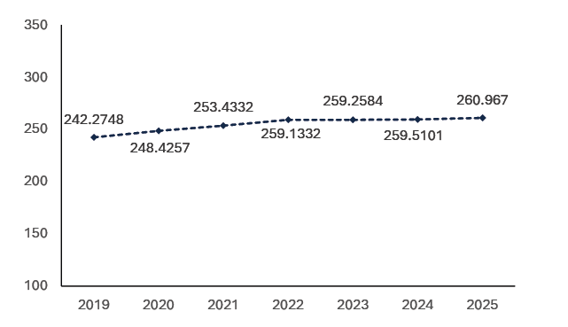
In 2025 there were 260.9659 (km²) of greenspace in urban areas in Scotland, representing a slight increase of 0.56% from the previous year. This highlights an increase over time since 2019, when there was 242.2748 (km²) of urban greenspace.
Green-blue land cover in urban areas reflects the extent of natural spaces in cities that provide crucial ecosystem services. It is relevant for climate adaptation as it captures how well cities are prepared to adapt to the challenges posed by climate change, making urban environments more sustainable and liveable. Urban greenspace contributes to temperature regulation during hot weather, biodiversity and wellbeing and flood resilience through water flow and run-off regulation.
NC1.2 – Proportion of adults who live withing a five-minute walk of their nearest green or blue space
Description: This indicator shows the proportion of adults in Scotland living within a five-minute walking distance of their nearest green or blue space
Data source: Scottish Household Survey
Ambition: Increasing over time
Actual trend: Too early to say
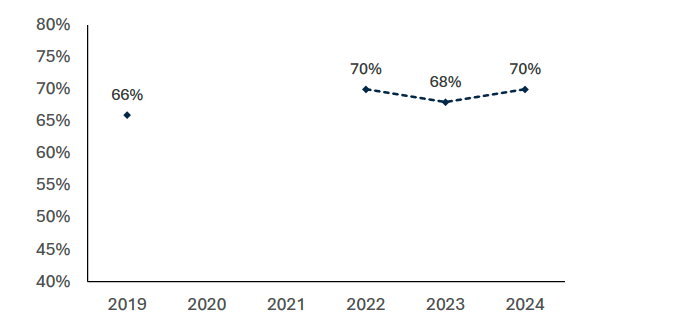
The percentage of respondents who reported living within a 5-minute walk of their nearest green or blue space increased very slightly between 2023 and 2024 (from 68% to 70%). Overall, in the period 2019 to 2024, the trend has been broadly flat, with this figure consistently lying between 66% and 70% each year.
As well as providing emotional and wellbeing benefits for people accessing them, local green space can contribute to temperature regulation during hot weather, brings biodiversity benefits and can improve flood resilience through water flow and run-off regulation.
Tests of statistical significance have been performed for differences between years. This data is an estimate, based on self-reported survey data. It is worth noting that the survey question is framed in terms of how long the respondent thinks it would take the interviewer (not interviewee) to walk to the nearest green or blue space to avoid variation due to differences in the ability to walk of interviewees.
NC2.1 – Newly protected land and marine features
Description: This indicator shows the number of hectares of newly protected land and marine features across Scotland
Data source: NatureScot
Ambition: Annual increase, maintained over time
Actual trend: Increasing
| Year | 2019 | 2020 | 2021 | 2022 | 2023 | 2024 | 2025 |
|---|---|---|---|---|---|---|---|
| Terrestrial | -11.37 | -348.05 | 0 | 2,445.80 | 5.4 | -30.54 | 3915.98 |
| Marine | 12,180.15 | 12,968,301.94 | 1,184.36 | 52,993.05 | 0.00 | 12,507.47 | 0.00 |
In 2025, an additional 3915.98 hectares were protected. Two terrestrial SSSI's were merged and extend with the net creation of 186.96 hectares of protected areas. The remaining 3729.02 hectares are from the creation of the first four terrestrial OECM's. There were no changes to the area of marine or mixed sites protected in Scotland.
Terrestrial and Marine area which are protected are likely to be in better ecological condition and therefore contributing more to Scotland's resilience to climate impacts.
NC2.2 – Hectares of Scotland’s protected features in favourable Condition
Description: This data demonstrates the reported condition of natural features (species, habitats and earth science) in protected sites across Scotland (Sites of Special Scientific Interest, Special Areas of Conservation, Special Protection Areas and Ramsar Sites). This includes features assessed as favourable, unfavourable recovering and unfavourable recovering due to management. These efforts will help to ensure habitats, processes and species are in good ecological health in Scotland.
Data source: NatureScot
Ambition: Increasing over time
Actual trend: Too early to say
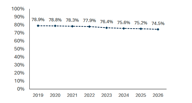
At March 31st, 2026, 74.5% of Scotland’s protected site features were in favourable condition.
The indicator is stable (less than 1% variation) compared to 2025 but has declined consistently since 2019. This is due to several factors including ongoing large-scale pressures, i.e., those that operate at larger scales than most protected areas, and the need to prioritise monitoring resources on features that are at higher risk of deterioration. Further years of data will be required to assess the trend from 2024 onwards since the beginning of SNAP3.
More insights into the data behind this indicator can be found at https://www.nature.scot/doc/official-statistics-protected-sites.
NC3.1 – Number of Local Development Plans adopted by local authorities since National Planning Framework 4 publication
Description: This indicator measures the number of Local Development Plans adopted by local authorities in Scotland since National Planning Framework 4 publication in 2023
Data source: Scottish Government
Ambition: Increasing over time
Actual trend: Preparation of LDPs follows a staged process and a target of May 2028 has been set for all authorities to adopt their new-style plans. Concerns exist over the slippage of timescales and Local Authority’s ability to meet this target.
No LDPs have currently been adopted by local authorities. All Local Authorities have started preparation of their new style LDPs with a majority expecting to adopt their plans during 2027. A second update provided in March 2026 indicated that 13 authorities are projected to adopt their new plans after the target date of May 2028.
In response to delays in the development of LDPs, in April 2025 Scottish Government put in place a requirement for authorities to provide 6-monthly updates on their timescales and action being taken to accelerate timescales, ensuring progress can be monitored.
- Scottish Government committed to offer support to all authorities through the National Planning Hub to assist in LDP preparation.
- A summit was also held with Local Authorities to consider collective action to speed up the process.
The first Proposed Plans are expected to be published in Spring 2026. Whilst plan preparation is the responsibility of planning authorities, we intend to take further action to support them to accelerate timescales and reduce delays.
NC4.1 – Number of nature networks across Scotland
Description: This indicator measures the number of local authorities reporting having spatially identified nature network(s) in their local authority area
Data source: Scottish Government
Ambition: Increasing over time
Actual trend: Increasing
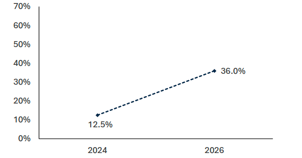
As of March 2026, 12 (36%) of 32 Local Authorities have either shared for advice, or published publicly, draft spatially identified Nature Networks across their local authority area. Of those who have published a draft, they are carrying out active consultation on their proposed Nature Network with the public, supporting an inclusive approach as outlined in Scottish Government's Framework for Delivering Nature Networks. Publication of a Nature Network indicates that Local Authorities are identifying connectivity between important areas for biodiversity including those sites contributing to 30x30.
Whilst not yet shared, a number of the remaining authorities have confirmed they have work underway to spatially define their networks. One National Park Authority has also published a draft of their Nature Network for consultation.
NC4.2 – Abundance of terrestrial species
Description: This indicator shows the percentage change in terrestrial species abundance across Scotland since 1994
Data source: NatureScot
Ambition: Maintaining or increasing over time
Actual trend: Too early to say (since publication of SNAP3 in 2024)
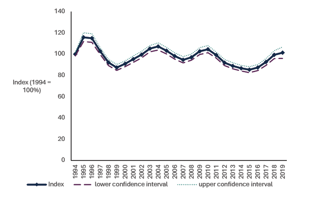
Note: data for this indicator has not been updated since the 2025 annual progress report. Data for this indicator is in development and will be included in SNAP3 progress reports when it is available.
From 1994 to 2019[30], the average abundance of 337 species of bird, mammals, butterflies and moths was stable. Average abundance shows peaks in 1995, 2004, 2010 and 2019. Between 2016 and 2019 the indicator increased by 14 percentage points.
Climate change is a significant and growing threat to biodiversity globally (IPBES 2019), and its impact is being increasingly detected in Scotland and its seas. The effects are many, and varied, with a mixed impact in biodiversity; presently, at least, many species are benefiting. For example, species are shifting ranges northwards, through Scotland, with consequent increases in abundance and range for birds such as nuthatches (Gillings et al. 2015)[31] and butterflies including ringlets (Fox et al. 2015)[32]. The species occupancy and abundance indicators in the SNAP3 framework provide an assessment of changes in biodiversity over time. A trend towards milder winters may have resulted in improved survival for bird species such as goldfinches. For many species, the influence of climate change may be serving to soften the impact of land-use changes and other adverse environmental changes. However, species with their southern range limits in Scotland, and those associated with cold montane habitats where, for example, duration of snow-lie is decreasing, are likely to undergo range contraction and possibly even extinction from Scotland (ASC 2016). Further threats arise from increased frequency and severity of storms and other extreme weather events, and the impact of sea-level rise on vulnerable coastal habitats.
NC4.3 – Occupancy of terrestrial species
Description: This indicator shows the percentage change in species occupancy across Scotland since 1994
Data source: NatureScot
Ambition: Increasing over time
Actual trend: Too early to say
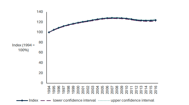
Note: data for this indicator has not been updated since the 2025 annual progress report. Data for this indicator is in development and will be included in SNAP3 progress reports when it is available.
Species occupancy represents the number of sites where a species is present. From 1994 to 2016, the average occupancy of 2,466 species of invertebrate, lichen and bryophyte increased by 24%. Between 2015 and 2016 the indicator was stable.
As with the species abundance indicators, this indicator provides an indicator of changes to biodiversity in Scotland over time.
More detailed information on the species abundance and occupancy indicators can be found in NatureScot’s 2022 publication.
NC5.1 – Abundance of marine species
Description: This indicator shows the percentage change in marine species abundance in Scotland since 1994
Data source: NatureScot
Ambition: Increasing over time
Actual trend: Too early to say
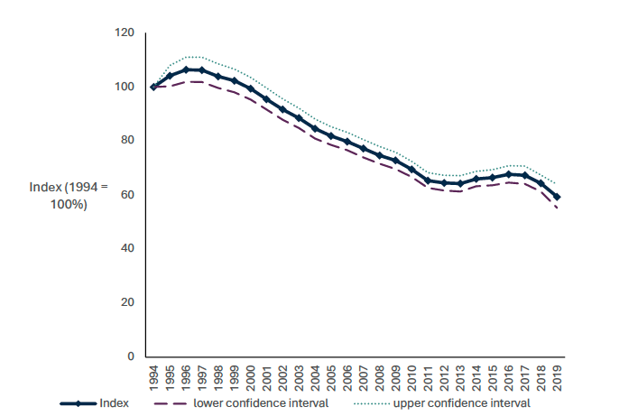
Note: data for this indicator has not been updated since the 2025 annual progress report. Data for this indicator is in development and will be included in SNAP3 progress reports when it is available.
From 1994 to 2019[33], the average abundance of 14 species of breeding seabird fell by 41%, with most of the decline occurring between 2000 and 2010. Between 2016 and 2019 the indicator declined by 8%.
In marine ecosystems climate change is having rapid and widespread effects through warming waters, salinity changes, acidification and seasonal stratification (MCCIP 2020). The impact of climate change is being felt through marine food webs, with changes in phytoplankton, feeding through to zooplankton (in which rapid northward shifts in range have been detected) to fish and top predators including large fish, seabirds and marine mammals. Declines in seabirds such as Kittiwakes have been linked to climate change impacts upon food webs including key prey species such as Sandeels (Carrol et al. 2017)[34].
NC6.1 – Hectares of restored peatland
Description: This indicator shows the hectares of restored peatland in Scotland in each financial year
Data source: NatureScot Peatland Action
Ambition: Increasing or maintained over time
Actual trend: Increasing
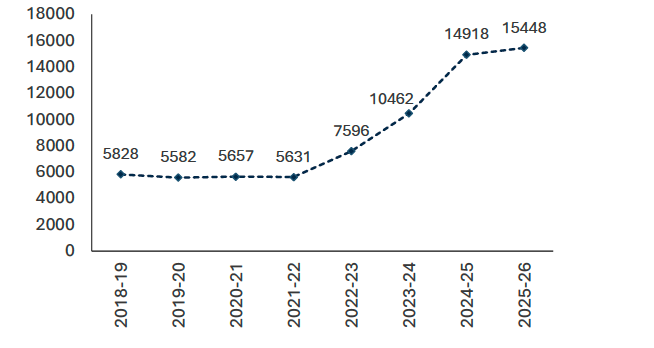
The area of peatland restored in each year has increased since 2021-22. 5,631 hectares of peatland were restored in 2021-22, with this rising to 14,918 in 2024-25 and 15,448 in 2025-26. Peatland restoration data is collated via the Peatland ACTION data portal[35]
The Peatland ACTION Partnership has been working to restore 250,000 hectares of degraded peatland by 2030. This target has been extended in the recently published Climate Change Plan to restore 400,000 hectares by 2040. The Scottish Budget 2025-26 committed £35.5 million towards peatland restoration. With this funding the Scottish Government has a target to restore at least 12,000 hectares in 2025-26. This target has been exceeded during this period.
Peatland restoration is crucial for climate resilience, providing ecosystem services such as capturing and storing water and carbon. There are numerous other co-benefits to society, including increasing biodiversity, improving water quality, and reducing risks of flooding and wildfires. Note that it can take several years before the benefits of peatland restoration are realised following restoration work. Some inferred adaptation benefits of healthy, resilient peatlands include:
- Healthy, rewetted peatlands are more resilient to climate impacts like droughts and can continue acting as carbon sinks rather than sources. Peatlands filter and improve water quality in their catchments. Restoring them helps maintain clean drinking water supplies in the face of climate impacts like droughts or contamination.
- Healthy and restored peatland help regulate water flow. Healthy peatlands with intact vegetation help prevent soil erosion, increasing resilience against climate change effects like intense rainfall.
- Peatlands are naturally wetter areas because of the higher water table. The wetter ground can help stop the spread of fires during droughts and dryer periods.
- Restoring peatlands protects their cultural significance and enables continued
recreational opportunities like hiking, supporting community resilience.
NC6.2 – Woodland creation
Description: This indicator shows the hectares of all woodland in Scotland created each year
Data source: Woodland Statistics (via Forest Research)
Ambition: Increasing over time
Actual trend: Too early to say
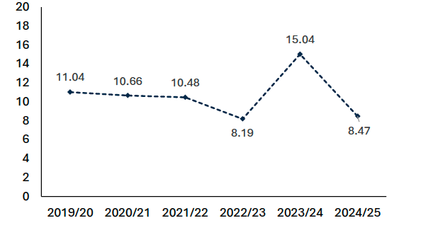
While too early to report confidently on a trend, data this year highlights a reduction in the hectares of woodland created in 2024/25 when compared to 2023/24.
In total, Scotland created 8,470 hectares of new forest or woodland, representing 54% of all UK new woodland creation. 5,300 hectares of native woodlands were created, surpassing the Scottish Government’s commitment of 4,000 hectares set out in the Programme for Government (PfG). Of this, 5,300 hectares represented native woodland. This compares to 15,000 hectares of new forest or woodland being planted during 2023/24 – which represented the highest level in 34 years.
Despite leading the UK in woodland creation, Scotland fell short of its broader targets: 10,000 hectares under the PfG and 18,000 hectares under the Climate Change Plan for 2024/25. This shortfall is being attributed to budget reductions in the previous year, which affected applicant confidence and reduced the speed at which applicants developed and delivered projects for planting this year. Furthermore, around 30% of projects approved by Scottish Forestry—amounting to 2,800 hectares—did not proceed or were planted to compensate for woodlands removed for electricity infrastructure projects, which means they cannot count towards new planting statistics.
Noticeable amongst the drop off of activity has been a reduction in the number of small-scale woodlands being planted by farmers or crofters, many of whom were affected by inflationary pressures that either delayed or halted progress. To help address inflation, every year Scottish Forestry will now allocate an additional £1 million in grant funding for smaller woodlands, aiming to encourage farmers and crofters to carry on with planting trees.
NC6.3 – Area of forest and woodland registered under the Woodland Carbon Code
Description: This indicator shows the area of forest and woodland registered in Scotland under the Woodland Carbon Code (WCC) in Hectares over time
Data source: Woodland Statistics (via Forest Research)
Ambition: Increasing over time
Actual trend: Increasing
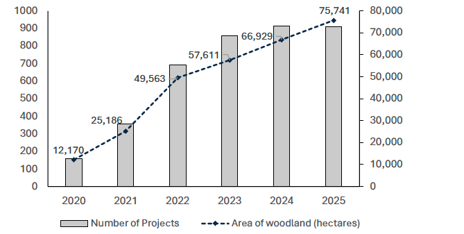
The area of forest and woodland registered under the Woodland Carbon Code has continued to increase year on year. There was a steep rise between 2021 and 2022 from 25,186 hectares to 49,563 hectares. The total hectares covered increased from 66,929 hectares in 2024 to 75,741 by 2025.
The total number of projects has fallen slightly since 2024 (from 914 in 2024 to 911 in 2025). This decrease is due to the merging of some smaller projects, rather than representing a decrease in activity.
The Woodland Carbon Code is the quality assurance standard for UK woodland creation projects which address climate change by removing carbon dioxide fromthe atmosphere. It encourages increased creation and supporting of woodland projects across the UK. Woodland creation has a number of co-benefits for climate change adaptation as well as the mitigation benefits. For example, they enhance biodiversity, regulate ecosystem services, provide environmental protection and offer opportunities for community benefits through access to nature.