Investigation into the long-finned pilot whale (Globicephala melas) mass stranding event, Tolsta, na h-Eileanan Siar, July 2023
This report details the comprehensive analysis into the mass stranding event (MSE) of long-finned pilot whales that occurred in Tolsta Bay, Isle of Lewis, Scotland, on 16 July 2023.
Section 8: Influence of wind and tide
Wind and tidal influences were investigated as potential contributing factors to the stranding event. Wind data for the 48 hours (Figure 15 & Table 3) preceding the stranding revealed a dominant northerly airstream, with a shift from northeasterly winds in the 24 hours prior to stranding, to more northerly and north-westerly winds in the six hours leading up to the event. Wind speeds remained moderate, not exceeding ten knots until the six hours prior to stranding, when gusts of 15-20 knots were recorded from the north. While these wind speeds are not uncommon for the area, the presence of a sustained northerly wind during this critical period could have played a role in pushing animals towards the shore and generating onshore surf. This may explain the high number of drowned individuals found during the early hours of 16 July 2023.
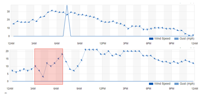
| Time | Wind | Wind Speed | Wind Gust | Pressure | Precip. | Condition |
|---|---|---|---|---|---|---|
| 12:20 AM | N | 7 mph | 0 mph | 29.09 in | 0.0 in | Light Drizzle |
| 12:50 AM | N | 6 mph | 0 mph | 29.12 in | 0.0 in | Cloudy |
| 1:20 AM | N | 7 mph | 0 mph | 29.12 in | 0.0 in | Cloudy |
| 1:50 AM | N | 8 mph | 0 mph | 29.12 in | 0.0 in | Cloudy |
| 2:20 AM | N | 7 mph | 0 mph | 29.15 in | 0.0 in | Cloudy |
| 2:50 AM | N | 8 mph | 0 mph | 29.15 in | 0.0 in | Cloudy |
| 3:20 AM | NNW | 10 mph | 0 mph | 29.15 in | 0.0 in | Cloudy |
| 3:50 AM | NNW | 7 mph | 0 mph | 29.15 in | 0.0 in | Cloudy |
| 4:20 AM | NW | 3 mph | 0 mph | 29.18 in | 0.0 in | Cloudy |
| 4:50 AM | N | 12 mph | 0 mph | 29.18 in | 0.0 in | Light Rain |
| 5:20 AM | NNW | 10 mph | 0 mph | 29.18 in | 0.0 in | Mostly Cloudy |
| 5:50 AM | NW | 12 mph | 0 mph | 29.18 in | 0.0 in | Cloudy |
| 6:20 AM | NW | 15 mph | 0 mph | 29.21 in | 0.0 in | Cloudy |
| 6:50 AM | NW | 18 mph | 0 mph | 29.21 in | 0.0 in | Cloudy |
| 7:20 AM | WNW | 13 mph | 0 mph | 29.21 in | 0.0 in | Cloudy |
| 7:50 AM | NW | 8 mph | 0 mph | 29.24 in | 0.0 in | Cloudy |
Detailed information on tidal processes at the specific stranding site on Tolsta Beach, Isle of Lewis, is limited. However, tidal data suggests a moderate mean spring tidal range of 3.5-4.0 meters, potentially increasing slightly towards the inner part of Broad Bay. Flood currents travel northwards up the Minch, with high tide occurring roughly synchronously across the area. The main tidal stream across the mouth of Broad Bay is weak, with a peak spring rate of less than 0.3 m/s. Currents within the bay are similarly weak. Ebb tide currents flow south off Tolsta Head, exhibiting a weak anticlockwise rotation within the bay. Flood tide currents are minimal along the north coast of the Eye Peninsula, with a weak NNE-flowing stream existing along the north coast of the bay, strengthening towards Tolsta Head (Ramsay and Bramgton 2000). These findings suggest that tidal processes likely played a minimal role in directly influencing the stranding event.
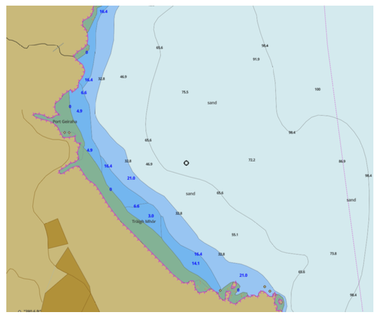
The stranding occurred on Tolsta Beach (Traigh Mhòr), a linear sandy beach with fine-grained sand, oriented northeast and facing the Minch. The beach extends uninterrupted for around 2.3 km, exhibits a gentle offshore gradient and is bounded to the south by a rock headland (Figure 16). Water depth drops gradually to around 25 meters within a few hundred meters offshore and only averages 50 meters around 4 km from shoreline. The geomorphology of this beach, comprising soft sand a shallow gradient and a headland-bay formation is consistent with mass stranding sites elsewhere (Hamilton and Lindsay 2014). Soft sand substrates are hypothesised to disrupt echolocation in cetaceans through a process termed "sonar termination" (Chambers and James 2005). This phenomenon suggests that pilot whales' biosonar signals may become attenuated or scattered in shallow waters with soft sediment, potentially hindering their ability to navigate effectively and locate deeper channels. Once the stranding event occurred, the combination of soft sand and potential onshore surf would have created a challenging environment for self-refloating. The animals limited manoeuvrability due to their large size and body shape, coupled with the lack of a firm substrate for propulsion and heavy surf would likely have significantly contributed to the high number of drowned mortalities observed.
Contact
Email: marine_species@gov.scot