
Fisheries Management Measures within Scottish Inshore Marine Protected Areas (MPAs) and Proposed Priority Marine Feature (PMF) Management Areas - High level Site Summary Details and Potential Impacts of Proposed Fisheries Management Measures
Overview of site and area details and potential impacts of the proposed fisheries management measures within Scottish Inshore Marine Protected Areas (MPAs) and proposed Priority Marine Feature (PMF) management areas

8. Argyll Scottish Marine Region Proposed PMF Management Areas
Due to the complexity and large number of areas, the estimated socio-economic impacts of proposed measures data has been produced at a regional level, allowing for a more consistent assessment across wider geographical scales while still capturing key variations in ecological, social, and economic value. Some values may not be disclosed for confidentiality reasons, as it relates to the operations of fewer than three vessels. Sites with a proposed single management option will be option 2.
|
Socio-Economic Impact |
Option 1 |
Option 2 |
|---|---|---|
|
Average annual loss in value of landings (£000s, 2022 prices) |
86.9 - 146.7 |
86.9 - 157.2 |
|
Direct + indirect reduction in GVA (PV) impact (£000s) 20 years |
649.4 - 1,093 |
649.4 - 1,170.4 |
|
Average (mean) number of direct + indirect jobs (year on year, over 20 years), Full Time Equivalents |
1 - 1.7 |
1 - 1.8 |
|
Environmental Impact |
Option 1 |
Option 2 |
|---|---|---|
|
Benefits within the sites/areas |
Major beneficial |
Major beneficial |
|
Spill over benefits |
Negligible beneficial |
Negligible beneficial |
|
Displacement effects |
Negligible adverse |
Negligible adverse |
|
Effects from other gear types |
Negligible adverse |
Negligible adverse |
|
Estimated overall environmental impact |
Benefit |
Benefit |
8.1. Single Proposed Management Option
PMF management areas will be closed to demersal trawls and seines, beam trawls, mechanical dredges, and hydraulic dredges. This is because the features present in these areas are sensitive to these gear types.
A single management option has been developed for the following 10 PMF management areas. Only one option was identified due to one of, or combination of, evidence (fishing activity or PMF related), boundary setting principles and compliance considerations.
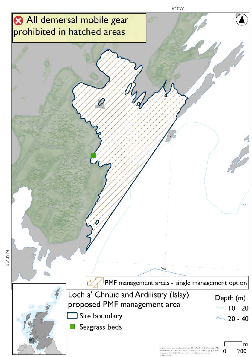
8.1.1. Area: Loch a' Chnuic and Ardilistry (Islay)
This proposed PMF management area overlaps with the South-East Islay Skerries SAC.
This PMF management area overlaps with management measures being consulted on for South-East Islay Skerries SAC for set nets (including fyke nets) and pelagic seine (including ring-nets) which are not shown in the map below.
Please check overlapping site map option(s) to see pelagic and static gear measures.
The boundary was reduced to the bay where the seagrass bed record is located. No additional fishing data were provided within the proposed PMF management area.
Feature: Seagrass beds
Figure 12. Map of measures proposed:
8.1.2. Area: Loch a' Chumhainn (Mull)
This is an area where the protection of the maerl beds contributes to the management required for the Inner Hebrides Carbonate Production Area of the Sea of the Hebrides NCMPA.
This proposed PMF management area overlaps with the Sea of the Hebrides NCMPA and Inner Hebrides and the Minches SAC.
This PMF management area overlaps with management measures being consulted on for Inner Hebrides and the Minches SAC and Sea of the Hebrides NCMPA for set nets (not including fyke nets) which are not shown in the map below.
Please check one of the overlapping site map option(s) to see static gear measures. Both sets of maps show the same thing for overlapping portion.
The boundary was extended slightly to straighten it at the mouth of the loch. No additional fishing data were provided within the proposed management area.
Feature: Maerl beds
Figure 13. Map of measures proposed:

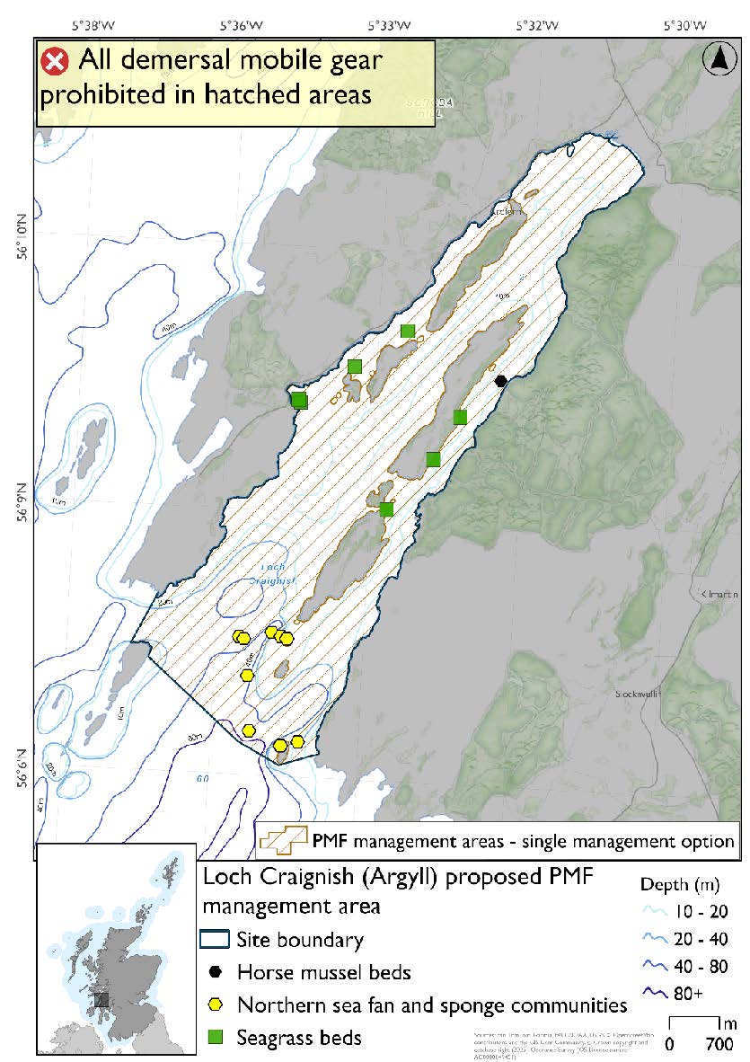
8.1.3. Area: Loch Craignish (Argyll)
This proposed PMF management area overlaps with the Inner Hebrides and the Minches SAC.
This PMF management area overlaps with management measures being consulted on for Inner Hebrides and the Minches SAC for set nets (not including fyke nets) which are not shown in the map below.
Please check overlapping site map option(s) to see static gear measures.
The boundary was extended slightly at the mouth of the loch to encompass additional northern sea fan and sponge communities records and taking into account additional fishing data provided.
Feature: Horse mussel beds, northern sea fan and sponge communities and seagrass beds.
Figure 14. Map of measures proposed:
8.1.4. Area: Loch Indaal (Islay)
Feature: Horse mussel beds and seagrass beds
There are also intertidal blue mussel beds present, but they were not considered as part of this process due to there being no overlaps with bottom-contacting fishing activity and intertidal mussel beds.
No additional fishing data were received within the proposed PMF management area.
Figure 15. Map of measures proposed:

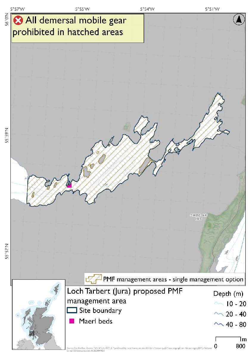
8.1.5. Area: Loch Tarbert (Jura)
Feature: Maerl beds
Based on available evidence NatureScot suggested this PMF management area could be reduced to include the rapids area and inner basins only. Fishing data were also used and amendments were made to reduce the area.
Figure 16. Map of measures proposed:
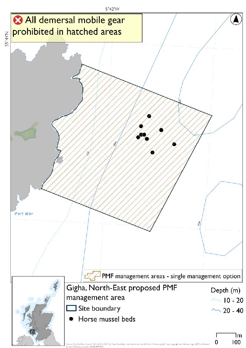
8.1.6. Area: Gigha, North-East
This proposed PMF management area overlaps with the Sound of Gigha SPA.
This PMF management area overlaps with management measures being consulted on for Sound of Gigha SPA for set nets (including fyke nets) which are not shown in the map below.
Please check overlapping site map option(s) to see static gear measures.
The area was reshaped to include the unprotected beds from a 2019 survey. No additional fishing data were provided within the proposed PMF management area.
Feature: Horse mussel beds
Figure 17. Map of measures proposed:
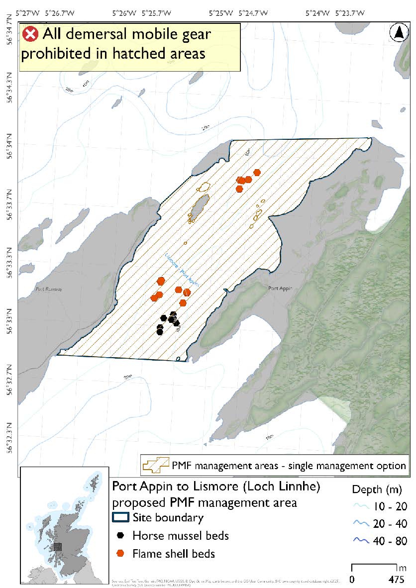
8.1.7. Area: Port Appin to Lismore (Loch Linnhe)
No additional fishing data were provided within the proposed PMF management area.
Feature: Flame shell beds and horse mussel beds
Figure 18. Map of measures proposed:
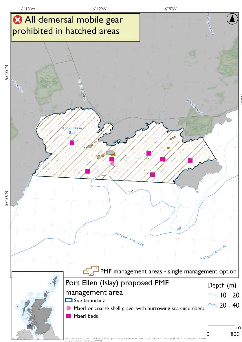
8.1.8. Area: Port Ellen (Islay)
The 2018 illustrative area was reshaped based on records of maerl beds and maerl and coarse shell gravel with burrowing sea cucumbers. No additional fishing data were provided within the proposed PMF management area.
Feature: Maerl beds and maerl or coarse shell gravel with burrowing sea cucumbers.
Figure 19. Map of measures proposed:
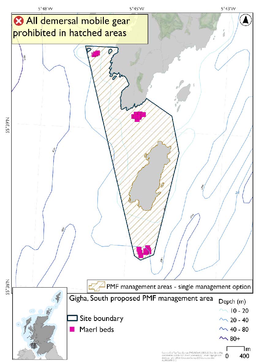
8.1.9. Area: Gigha, South
This proposed PMF management area overlaps with the Sound of Gigha SPA.
This PMF management area overlaps with management measures being consulted on for Sound of Gigha SPA for set nets (including fyke nets) which are not shown in the map below.
Please check overlapping site map option(s) to see static gear measures.
This proposed area was developed around the distribution of maerl bed records and adjustments were made to avoid the majority of the fishing activity data provided whilst still protecting all records.
Feature: Maerl beds
Figure 20. Map of measures proposed:
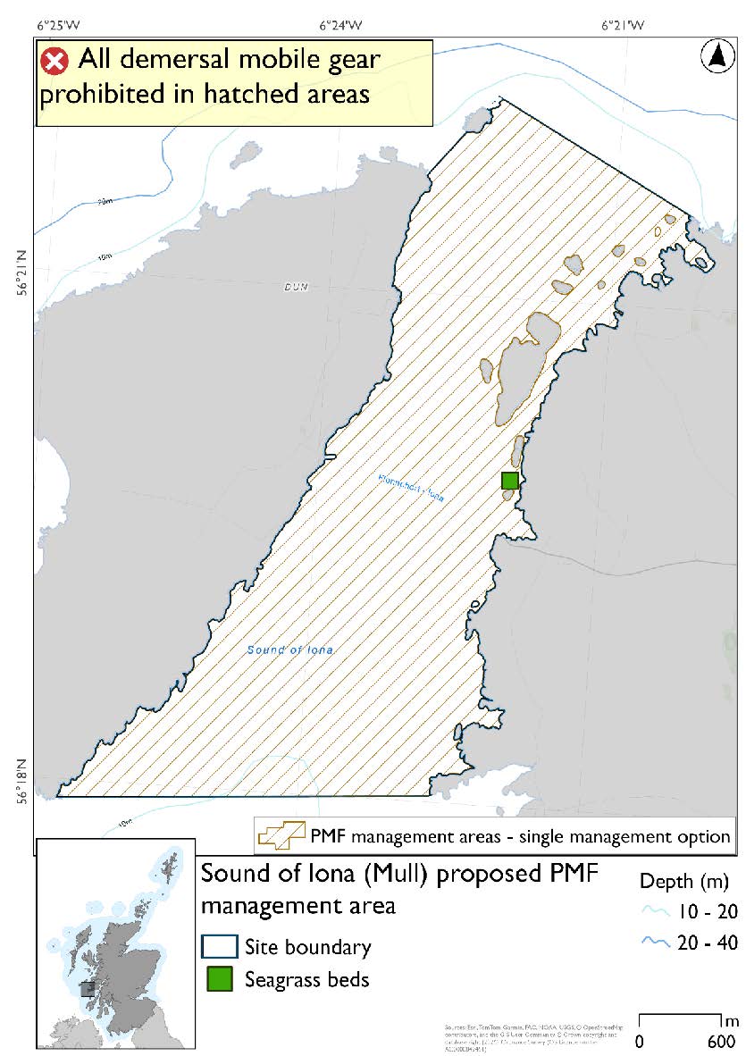
8.1.10. Area: Sound of Iona (Mull)
This is an area where the protection of seagrass beds contributes to the management required for the Inner Hebrides Carbonate Production Area of the Sea of the Hebrides NCMPA.
This proposed PMF management area overlaps with the Sea of the Hebrides NCMPA and Inner Hebrides and the Minches SAC.
This PMF management area overlaps with management measures being consulted on for Inner Hebrides and the Minches SAC and Sea of the Hebrides NCMPA for set nets (not including fyke nets) which are not shown in the map below.
Please check one of the overlapping site map option(s) to see static gear measures. Both sets of maps show the same thing for overlapping portion.
NatureScot are aware of further PMF evidence to support this area that did not make the data cut-off date for areas being finalised for consultation. No additional fishing data were provided within the proposed management area.
Feature: Seagrass beds
Figure 21. Map of measures proposed:
8.2. Two Proposed management options
PMF management areas will be closed to demersal trawls and seines, beam trawls, mechanical dredges, and hydraulic dredges. This is because the features present in these areas are sensitive to these gear types.
Two options have been developed for the following 3 PMF management areas. Option 1 reflects a smaller footprint that reflects one, or a combination of evidence (fishing activity or PMF related), boundary setting principles and compliance considerations. Option 2 covers a larger footprint that offers improved protection.
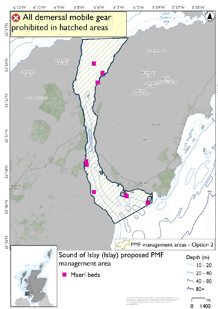
8.2.1. Area: Sound of Islay (Islay)
This proposed PMF management area overlaps with the Sea of the Hebrides NCMPA and Inner Hebrides and the Minches SAC.
This PMF management area overlaps with management measures being consulted on for Inner Hebrides and the Minches SAC and Sea of the Hebrides NCMPA for set nets (not including fyke nets) which are not shown in the maps below.
Please check one of the overlapping site map option(s) to see static gear measures. Both sets of maps show the same thing for overlapping portion.
Feature: Maerl beds
Option 1: This boundary covers a smaller footprint more closely following the known records of PMFs in the southern end of the sound. Additional fishing data were provided and amendments were made in the southern end of the area to enable the majority of this activity to continue, whilst protecting the records.
Figure 22. Map of measures proposed under option 1:

Option 2: This boundary covers a larger footprint, with an extended boundary in the south west that offers improved protection.
Figure 23. Map of measures proposed under option 2:
8.2.2. Area: Ulva and Loch na Keal (Mull)
This is an area where the protection of the maerl and seagrass beds contributes to the management required for the Inner Hebrides Carbonate Production Area of the Sea of the Hebrides NCMPA.
This proposed PMF management area overlaps with the Sea of the Hebrides NCMPA and Inner Hebrides and the Minches SAC.
This PMF management area overlaps with management measures being consulted on for Inner Hebrides and the Minches SAC and Sea of the Hebrides NCMPA for set nets (not including fyke nets) which are not shown in the maps below.
Please check both site map options to see static gear measures. Each map will show the same overlapping measures but cover different areas.
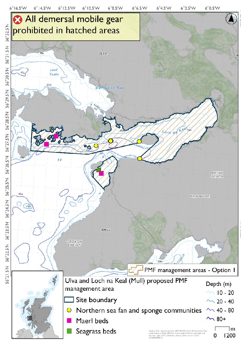
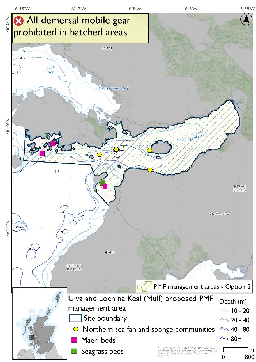
Feature: Maerl beds, northern sea fan and sponge communities and seagrass beds
Option 1: This boundary covers a smaller footprint over two discrete areas that reflects the extent of PMF records. Additional fishing data provided showed activity in the middle area, south of Ulva and into Loch na Keal and therefore option 1 was split into two areas. The two northern sea fan and sponge community records at Eorsa may have natural protection from the rocky outcrops here and so the decision was taken to position the boundary to still afford protection but enable fishing activity.
Figure 24. Map of measures proposed under option 1:
Option 2: This boundary covers a larger footprint that offers improved protection.
Figure 25. Map of measures proposed under option 2:
8.2.3. Area: West Loch Tarbert (Kintyre)
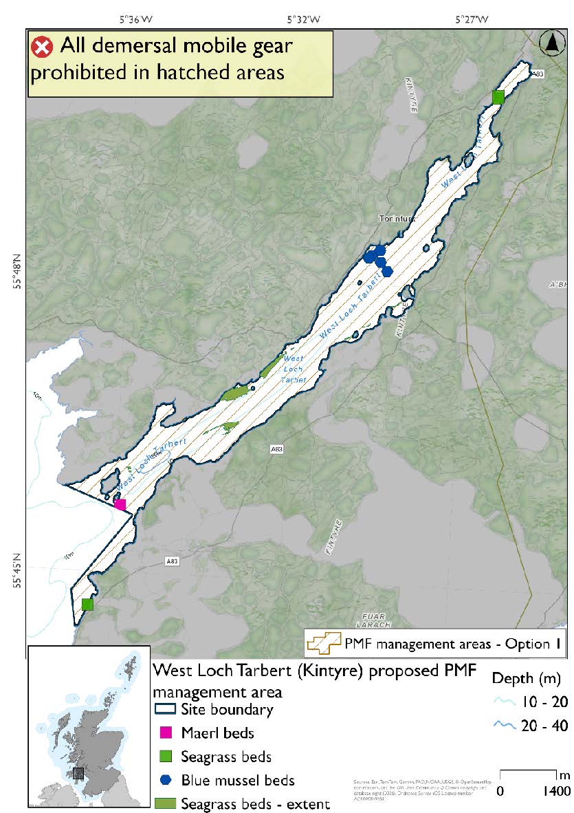
Feature: Maerl beds and seagrass beds
This proposed PMF management area overlaps with the Sound of Gigha SPA and Inner Hebrides and the Minches SAC.
This PMF management area overlaps with management measures being consulted on for Sound of Gigha SPA for set nets (including fyke nets) and Inner Hebrides and the Minches SAC for set nets (not including fyke nets) which are not shown in the maps below.
Please check overlapping site map option(s) to see to see static gear measures.
Option 1: This boundary covers a smaller footprint, more closely following depths suitable for the PMFs at the mouth of the loch. This area was reduced to accommodate additional fishing data provided without impacting on known records.
Figure 26. Map of measures proposed under option 1:
Option 2: This boundary covers a larger footprint that offers improved protection.
Figure 27. Map of measures proposed under option 2:

Contact
Email: marine_biodiversity@gov.scot