
Fisheries Management Measures within Scottish Inshore Marine Protected Areas (MPAs) and Proposed Priority Marine Feature (PMF) Management Areas - High level Site Summary Details and Potential Impacts of Proposed Fisheries Management Measures
Overview of site and area details and potential impacts of the proposed fisheries management measures within Scottish Inshore Marine Protected Areas (MPAs) and proposed Priority Marine Feature (PMF) management areas

23. West Highlands Scottish Marine Region MPAs
Due to the complexity and large number of areas and sites, ecosystem services data has been produced at a regional level, allowing for a more consistent assessment across wider geographical scales while still capturing key variations in ecological, social, and economic value.
|
Total value of changes in ecosystem services |
Option 1 Min |
Option 1 Max |
Option 2 Min |
Option 2 Max |
|---|---|---|---|---|
|
Benefits |
Low: protection to help maintain, with low potential to increase |
Low: protection to help maintain, with low potential to increase |
High: protection will maintain, low potential to increase |
High: protection will maintain, low potential to increase |
|
Costs |
Low |
Minimal |
Moderate - |
Moderate - high |
|
Net Impacts |
Small Benefit |
Small Benefit |
Small Benefit |
Small Benefit |
23.1. Site: Small Isles NCMPA
Protected features:
- Black guillemot
- Burrowed mud
- Circalittoral sand and mud communities
- Fan mussel aggregations
- Horse mussel beds
- Northern feather star aggregations on mixed substrata
- Northern sea fan and sponge communities
- Quaternary of Scotland
- Shelf deeps
- White cluster anemones
Quaternary of Scotland and shelf deeps are not discussed further as they are not protected features for which fisheries management measures are required.
Feature conditions:
- Black guillemot - Unfavourable
- Burrowed mud - Favourable
- Circalittoral sand and mud communities - Favourable
- Fan mussel aggregations - Favourable
- Horse mussel beds - Favourable
- Northern feather star aggregations on mixed substrata - Favourable
- Northern sea fan and sponge communities - Favourable
- White cluster anemones – Favourable
Conservation objectives:
- Black guillemot - Recover
- Burrowed mud - Conserve
- Circalittoral sand and mud communities - Conserve
- Fan mussel aggregations - Conserve
- Horse mussel beds - Conserve
- Northern feather star aggregations on mixed substrata - Conserve
- Northern sea fan and sponge communities - Conserve
- White cluster anemones – Conserve
The proposed management measures for Small Isles NCMPA are as follows:
Option 1:
- Demersal trawl and mechanical dredge by vessels with engine power over 500 KW prohibited throughout site
- Demersal trawl and mechanical dredge by vessels with engine power 500 KW or less permitted in part of the site
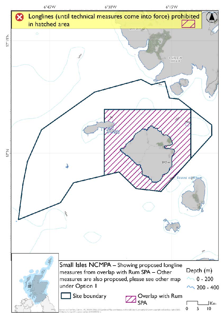
- Longlines (until technical measures come into force) prohibited in overlapping areas with Rum SPA
- Full site closure to demersal seine net and beam trawls, set nets (including fyke nets) and hydraulic dredge.
Figure 199. Map of measures proposed under option 1:

Figure 200. Map of measures proposed under option 1:
Option 2:*
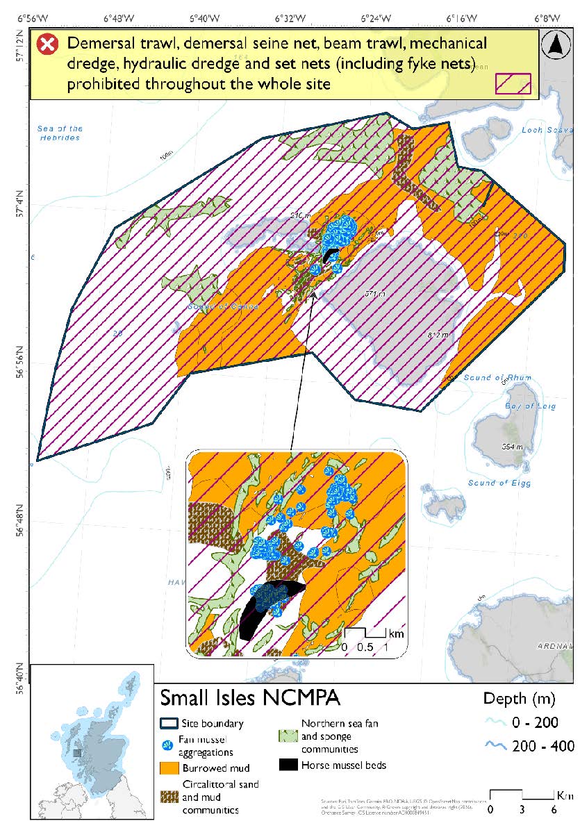
- Full site closure to demersal trawl and seine, beam trawls, mechanical dredge, hydraulic dredge and set nets (including fyke nets)
Figure 201. Map of measures proposed under option 2:
*The measures for Option 2 proposals only come from gear types prohibited in non-overlapping areas. Overlapping restrictions may still apply from overlapping sites or areas dependent on the decisions taken for that site or area.
Overlapping sites included in this consultation
This NCMPA overlaps with the Canna and Sanday and Rum SPAs, Sea of the Hebrides NCMPA and Inner Hebrides and the Minches SAC.
|
Socio-Economic Impact |
Option 1 |
Option 2 |
|---|---|---|
|
Average annual loss in value of landings (£000s, 2022 prices) |
0.1 - 171 |
1,083.4 - 1,218.8 |
|
Direct + indirect reduction in GVA (PV) impact (£000s) 20 years |
0.1 - 1,256 |
7,938.1 - 8,941.2 |
|
Average (mean) number of direct + indirect jobs (year on year, over 20 years), Full Time Equivalents |
0 - 1.9 |
12.3 - 13.8 |
|
Environmental Impact |
Option 1 |
Option 2 |
|---|---|---|
|
Benefits within the sites/areas |
Major beneficial |
Major beneficial |
|
Spill over benefits |
Negligible beneficial |
Minor beneficial |
|
Displacement effects |
Negligible adverse |
Negligible adverse |
|
Effects from other gear types |
Negligible adverse |
Minor adverse |
|
Estimated overall environmental impact |
Benefit |
Benefit |
23.2. Site: Ascrib, Isay and Dunvegan SAC
Protected features:
- Harbour Seal
Feature conditions:
- Harbour Seal - Favourable
Conservation objectives:
- Harbour Seal - Maintain
The proposed management measure for Ascrib, Isay and Dunvegan SAC is as follows:
Single Proposed Management Option:*
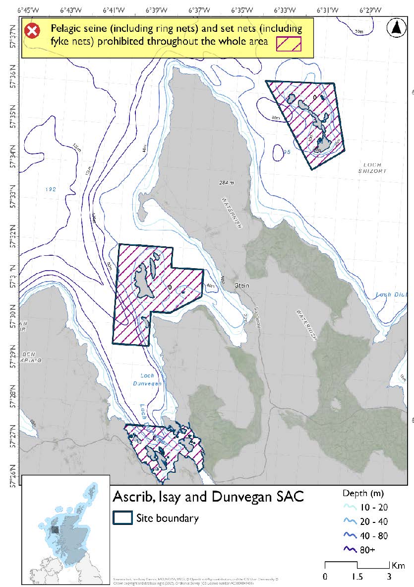
- Full site closure to set nets (including fyke nets) and pelagic seine (including ring-nets).
Figure 202. Map of measures proposed:
A full site level of protection from the specified gear has been identified as the only suitable option in enabling the achievement of the desired level of protection for the feature in question.
*This site will have other demersal mobile measures that may apply from the overlapping portions with the Inner Hebrides and the Minches SAC and proposed PMF management areas that aren’t shown on the map for this option.
- Inner Hebrides and the Minches SAC would prohibit hydraulic dredge across the entire site
- The proposed PMF management areas would prohibit all demersal mobile gear from the entire area that overlaps. (see section below for overlapping areas)
Please check the Option 1 or single management overlapping site and area maps to see proposed demersal mobile measures under Option 1.
Overlapping sites and areas included in this consultation
This SAC overlaps Inner Hebrides and the Minches SAC and the Loch Bay (Skye), and Ascrib Islands (Skye) proposed PMF management areas.
Estimated Socio-economic impacts of proposed measures for Ascrib, Isay and Dunvegan SAC
No socio-economic impacts are anticipated for this site, based on available data in relation to:
- Average annual loss in value of landings (£000s, 2022 prices)
- Direct + indirect reduction in GVA (PV) impact (£000s) 20 years
- Average (mean) number of direct + indirect jobs (year on year, over 20 years), Full Time Equivalents
|
Environmental Impact |
Option 1 |
Option 2 |
|---|---|---|
|
Benefits within the sites/areas |
Minor beneficial |
Minor beneficial |
|
Spill over benefits |
None |
None |
|
Displacement effects |
None |
None |
|
Effects from other gear types |
None |
None |
|
Estimated overall environmental impact |
Benefit |
Benefit |
23.3. Site: Inner Hebrides and the Minches SAC
Protected features:
- Harbour porpoise
Feature conditions:
- Harbour porpoise - Favourable
Conservation objectives:
- Harbour porpoise – Maintain
- Longlines (until technical measures come into force) prohibited, demersal set nets (including fyke nets) prohibited from February till end of August and pelagic set nets prohibited in areas deeper than 64.5m based on presence of guillemot and shag in overlapping area with Shiant Isles SPA.(Fill 12)
- Demersal set nets prohibited from April till the end of October and pelagic set nets prohibited in overlapping areas with Coll and Tiree SPA that are deeper than 60m, based on presence of eider (Fill 13)
- Full site closure to hydraulic dredge
This SAC has two maps for Option 1 due to its size. The proposed management measures for Inner Hebrides and the Minches SAC are as follows:
Option 1:*
- Set nets (not including fyke nets) prohibited (Hatching 1)
- Set nets (not including fyke nets and tangle nets) prohibited (Hatching 2)
- Set nets (including fyke nets) and hydraulic dredge already prohibited and pelagic seine (including ring-nets) prohibited in overlapping areas with Eileanan agus Sgeiran Lios mor SAC from measures already in place from Loch Sunart to Sound of Jura NCMPA (Hatching 3)
- Pelagic set nets prohibited in overlapping areas with West Coast of the Outer Hebrides and Sound of Gigha SPAs that are deeper than 60m based on presence all species (Fill 4)
- Set nets (including fyke nets) and pelagic seine (including ring-nets) prohibited in overlapping area with the Ascrib, Isay & Dunvegan SAC (Hatching 5)
- Set nets (including fyke nets) prohibited in overlapping areas with the Small Isles NCMPA (includes part of Canna and Sanday SPA), Sound of Gigha (shallower than 60m) and Coll & Tiree (shallower than 60m) based on presence and maximum dive depths of protected features (Hatching 6)
- Set nets and hydraulic dredge already prohibited in overlapping areas with Red Rocks and Longay NCMPA, Loch Sunart to the Sound of Jura NCMPA, Treshnish Isles SAC and BUTEC range (Hatching 7)
- Set nets (including fyke nets) prohibited from February until end of August based on presence and maximum dive depth for guillemot in overlapping area with North West Colonsay and Western Cliffs SPA. (Hatching 8)
- Longlines prohibited (until technical measures come into force) prohibited, demersal set nets (including fyke nets) prohibited February till end of August and pelagic set nets prohibited February till mid-October in overlapping portion of Rum SPA deeper than 32.7m but shallower than 177m based on maximum dive depth of guillemot and presence of guillemot and Manx shearwater. (Hatching 9)
- Longlines (until technical measures come into force) prohibited and set nets (including fyke nets) prohibited February till mid-October in overlapping portion of the Rum SPA shallower than 32.7m, based on mean dive depth (maximum unknown) and presence of Manx shearwater. (Fill 10)
- Longlines (until technical measures come into force) and set nets (including fyke nets) prohibited in overlapping areas with Rum and Shiant Isles SPAs (Hatching 11)
Figure 203. Map of measures proposed under option 1:

Figure 204. Map of measures proposed under option 1:

*This site will have other demersal mobile measures that may apply from the overlapping portions with the proposed PMF management areas, NCMPAs and SACs that aren’t shown on the map for this option.
- Small Isles NCMPA and Sound of Arisaig (loch Ailort to Loch Ceann Traigh) SAC (including marine component of Loch Moidart and Loch Shiel Woods) SACs have zoned measures for demersal trawl and seine, beam trawl, hydraulic dredge and mechanical dredge. Measures would depend on where overlap occurs
- Shiant East Bank NCMPA would prohibit all demersal mobile gear in the overlapping area
- The proposed PMF management areas would prohibit all demersal mobile gear from the entire area that overlaps (see section below for overlapping areas)
Please check the Option 1 or single management overlapping site and area maps to see proposed demersal mobile measures under Option 1.
Option 2:*
- Full site closure to set nets (not including fyke nets) and hydraulic dredge.
Figure 205. Map of measures proposed under option 2:

*The measures for Option 2 proposals only come from gear types prohibited in non-overlapping areas. Overlapping restrictions may still apply from overlapping sites or areas dependent on the decisions taken for that site or area.
Overlapping sites and areas included in this consultation
This SAC overlaps with:
- North-East Lewis, Small Isles and Shiant East Bank NCMPAs
- Ascrib, Isay and Dunvegan, Eileanan agus Sgeiran Lios mór and Sound of Arisaig (loch Ailort to Loch Ceann Traigh) (including marine component of Loch Moidart and Loch Shiel Woods SAC) SACs
- North Colonsay and Western Cliffs, Sound of Gigha, Canna and Sanday SPA, Rum, Coll and Tiree, Shiant Isles and West Coast of the Outer Hebrides SPAs
- East Loch Tarbert and Scalpay (Harris), Loch Scavaig (Skye), Eigg, South-East, Muck and Godag, South of Muck and Bo Fascadale, Loch a' Chumhainn (Mull), Sound of Islay (Islay), Loch nan Ceall (Arisaig), Loch nan Uamh (Arisaig), Sandaig Bay, Loch Nevis (Knoydart), Loch Bay (Skye), Lochs Eishort and Slapin (Skye), Port Erradale (Gairloch), Ulva and Loch na Keal (Mull), Loch Craignish (Argyll), North of Crowlin Islands and Eilean na Ba (Inner Sound), Pabay, North (Inner Sound), Pabay, South-West (Inner Sound), Red Point (Torridon), Rubha Chuaig (Inner Sound), Scalpay, North (Inner Sound), Sound of Iona (Mull), West Loch Tarbert (Kintyre), East of BUTEC (Inner Sound), Loch Sligachan (Skye), Loch Ainort and Caolas Scalpay (Skye), Ascrib Islands (Skye), Little Minch and Loch Bracadale (Skye) proposed PMF management areas.
Estimated Socio-economic impacts of proposed measures for Inner Hebrides and the Minches SAC
Values in relation to:
- Average annual loss in value of landings (£000s, 2022 prices)
- Direct + indirect reduction in GVA (PV) impact (£000s) 20 years
- Average (mean) number of direct + indirect jobs (year on year, over 20 years), Full Time Equivalents.
cannot be disclosed for confidentiality reasons, as it relates to the operations of fewer than three vessels.
|
Environmental Impact |
Option 1 |
Option 2 |
|---|---|---|
|
Benefits within the sites/areas |
Major beneficial |
Major beneficial |
|
Spill over benefits |
Negligible beneficial |
Negligible beneficial |
|
Displacement effects |
Negligible adverse |
Negligible adverse |
|
Effects from other gear types |
Negligible adverse |
Negligible adverse |
|
Estimated overall environmental impact |
Benefit |
Benefit |
23.4. Site: Sound of Arisaig (loch Ailort to Loch Ceann Traigh) SAC (including marine component of Loch Moidart and Loch Shiel Woods SAC)
Protected features:
Sound of Arisaig SAC has been designated to protect
- Subtidal sandbanks
Marine component of the Loch Moidart and Loch Sheil Woods SAC has been designated to protect:
- Intertidal mudflats and sandflats
Feature conditions:
Sound of Arisaig SAC has been designated to protect
- Subtidal sandbanks - Favourable
Marine component of the Loch Moidart and Loch Sheil Woods SAC has been designated to protect:
- Intertidal mudflats and sandflats - Favourable
Conservation objectives:
Sound of Arisaig SAC has been designated to protect
- Subtidal sandbanks - Maintain
Marine component of the Loch Moidart and Loch Sheil Woods SAC has been designated to protect:
- Intertidal mudflats and sandflats - Maintain
The proposed management measures for Sound of Arisaig (loch Ailort to Loch Ceann Traigh) SAC (including marine component of Loch Moidart and Loch Shiel Woods SAC) are as follows:
Option 1:*
- Demersal trawls or seines prohibited in part of site
- Full site closure to beam trawls, mechanical dredge and hydraulic dredge.
Figure 206. Map of measures proposed under option 1:

*This site will have other measures that may apply from the overlapping portions with the Inner Hebrides and the Minches SAC that aren’t shown on the map for this option.
- Inner Hebrides and the Minches would prohibit set nets (not including fyke nets) in overlapping areas.
Please check the Option 1 overlapping site maps to see proposed demersal mobile measures under Option 1.
Option 2:*
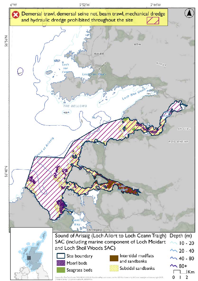
- Full site closure to demersal trawl and seine, beam trawl, mechanical dredge and hydraulic dredge.
Figure 207. Map of measures proposed under option 2:
*The measures for Option 2 proposals only come from gear types prohibited in non-overlapping areas. Overlapping restrictions may still apply from overlapping sites or areas dependent on the decisions taken for that site or area.
Overlapping sites included in this consultation
This SAC overlaps with the Inner Hebrides and the Minches SAC.
|
Socio-Economic Impact |
Option 1 |
Option 2 |
|---|---|---|
|
Average annual loss in value of landings (£000s, 2022 prices) |
0 - 2.7 |
0 - 17.7 |
|
Direct + indirect reduction in GVA (PV) impact (£000s) 20 years |
0 - 20.2 |
0 - 129.5 |
|
Average (mean) number of direct + indirect jobs (year on year, over 20 years), Full Time Equivalents |
0 - 0 |
0 - 0.2 |
|
Environmental Impact |
Option 1 |
Option 2 |
|---|---|---|
|
Benefits within the sites/areas |
Major beneficial |
Major beneficial |
|
Spill over benefits |
Negligible beneficial |
Negligible beneficial |
|
Displacement effects |
Negligible adverse |
Negligible adverse |
|
Effects from other gear types |
Negligible adverse |
Negligible adverse |
|
Estimated overall environmental impact |
Benefit |
Benefit |
23.5. Site: Canna and Sanday SPA
Protected features:
- Guillemot – breeding
- Herring gull – breeding
- Kittiwake – breeding
- Puffin – breeding
- Shag - breeding
Feature conditions:
- Guillemot - Unfavourable
- Herring gull - Unfavourable
- Kittiwake - Favourable
- Puffin - Favourable
- Shag - Unfavourable
Conservation objectives:
- Guillemot - Restore
- Herring gull - Restore
- Kittiwake - Maintain
- Puffin - Maintain
- Shag – Restore
The proposed management measure for Canna and Sanday SPA is as follows:
Single Proposed Management Option:*
- Full site closure to set nets (including fyke nets) and hydraulic dredge based on overlapping measures from Small Isles NCMPA
- Longlines (until technical measures come into force) prohibited in overlapping portion with the Rum SPA.
Figure 208. Map of measures proposed:

A full site level of protection from the specified gear has been identified as the only suitable option in enabling the achievement of the desired level of protection for the feature in question.
*This site will have other demersal mobile measures that may apply from the overlapping portions with the Small Isles NCMPA that aren’t shown on the map for this option.
- Small Isles NCMPA has zoned measures for demersal trawl, demersal seine net, beam trawl and mechanical dredge. Measures would depend on where overlap occurs.
Please check the Option 1 overlapping site map to see proposed demersal mobile measures under Option 1.
Overlapping sites included in this consultation
This SPA overlaps with the Small Isles and Sea of the Hebrides NCMPAs, Rum SPA and Inner Hebrides and the Minches SAC.
Estimated Socio-economic impacts of proposed measures for Canna and Sanday SPA
No socio-economic impacts are anticipated for this site, based on available data in relation to:
- Average annual loss in value of landings (£000s, 2022 prices)
- Direct + indirect reduction in GVA (PV) impact (£000s) 20 years
- Average (mean) number of direct + indirect jobs (year on year, over 20 years), Full Time Equivalents
|
Environmental Impact |
Single Proposed Management Option |
|---|---|
|
Benefits within the sites/areas |
Moderate beneficial |
|
Spill over benefits |
None |
|
Displacement effects |
None |
|
Effects from other gear types |
None |
|
Estimated overall environmental impact |
Benefit |
23.6. Site: Handa SPA
Protected features:
- Fulmar – breeding
- Great skua – breeding
- Guillemot – breeding
- Kittiwake – breeding
- Razorbill – breeding
Feature conditions:
- Fulmar – Unfavourable
- Great skua – Favourable
- Guillemot – Unfavourable
- Kittiwake – Unfavourable
- Razorbill – Unfavourable
Conservation objectives:
- Fulmar – Restore
- Great skua – Maintain
- Guillemot – Restore
- Kittiwake – Restore
- Razorbill – Restore
The proposed management measures for Handa SPA are as follows:
Option 1:*
- Set nets (including fyke nets) prohibited from February till end of August in areas down to 177m based on presence and maximum dive depth for guillemot
- Full site closure to longlines (until technical measures come into force) and hydraulic dredge.
Figure 209. Map of measures proposed under option 1:
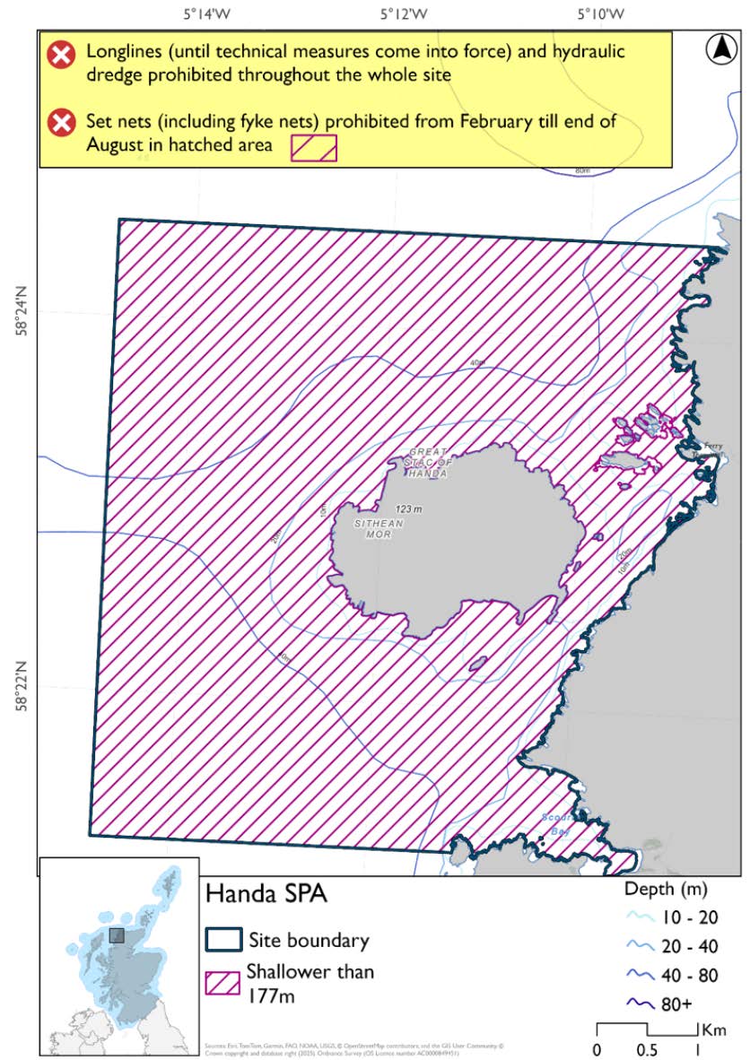
*This site will have other demersal mobile measures that may apply from the overlapping portions with the proposed PMF management that aren’t shown on the map for this option.
- The proposed PMF management areas would prohibit all demersal mobile gear from the entire area that overlaps. (see section below for overlapping areas)
Please check the Option 1 or single management overlapping area map to see proposed demersal mobile measures under Option 1.
Option 2:*
- Full site closure to longlines (until technical measures come into force), set nets (including fyke nets) and hydraulic dredge.
Figure 210. Map of measures proposed under option 2:

*The measures for Option 2 proposals only come from gear types prohibited in non-overlapping areas. Overlapping restrictions may still apply from overlapping sites or areas dependent on the decisions taken for that site or area.
Overlapping areas included in this consultation
This SPA overlaps with the Handa (Durness) proposed PMF management area.
Estimated Socio-economic impacts of proposed measures for Handa SPA
No socio-economic impacts are anticipated for this site, based on available data in relation to:
- Average annual loss in value of landings (£000s, 2022 prices)
- Direct + indirect reduction in GVA (PV) impact (£000s) 20 years
- Average (mean) number of direct + indirect jobs (year on year, over 20 years), Full Time Equivalents
|
Environmental Impact |
Option 1 |
Option 2 |
|---|---|---|
|
Benefits within the sites/areas |
Moderate beneficial |
Moderate beneficial |
|
Spill over benefits |
None |
None |
|
Displacement effects |
None |
None |
|
Effects from other gear types |
None |
None |
|
Estimated overall environmental impact |
Benefit |
Benefit |
23.7. Site: Rum SPA
Protected features:
- Golden eagle – breeding
- Guillemot – breeding
- Kittiwake – breeding
- Manx shearwater – breeding
- Red-throated diver – breeding
Golden eagle not discussed further as they are not a protected feature for which fisheries management measures are required.
Feature conditions:
- Guillemot – Unfavourable
- Kittiwake – Unfavourable
- Manx shearwater – Favourable
- Red-throated diver – Favourable
Conservation objectives:
- Guillemot – Restore
- Kittiwake – Restore
- Manx shearwater – Maintain
- Red-throated diver – Maintain
NatureScot provided amalgamated season advice for this site but individual seasonality for species has been used to develop consultation options.
The proposed management measures for Rum SPA are as follows:
Option 1:*
- Set nets (including fyke nets) prohibited February till mid-October in areas shallower than 32.7m based on presence and mean dive depth for Manx shearwater, maximum dive depth unknown.
- Demersal set nets (including fyke nets) prohibited February till end of August and pelagic set nets prohibited February till mid-October in areas deeper than 32.7m based on presence of guillemot and Manx shearwater
- Set nets (including fyke nets) prohibited in area that overlaps with the Small Isles NCMPA.
- Full site closure to longlines (until technical measures come into force) and hydraulic dredge.
Figure 211. Map of measures proposed under option 1:

*This site will have other demersal mobile measures that may apply from the overlapping portions with the Small Isles NCMPA that aren’t shown on the map for this option.
- Small Isles NCMPA has zoned measures for demersal trawl, demersal seine net, beam trawl and mechanical dredge. Measures would depend on where overlap occurs.
Please check the Option 1 overlapping site map to see proposed demersal mobile measures under Option 1
Option 2*
- Full site closure to longlines (until technical measures come into force), set nets (including fyke nets), and hydraulic dredge
Figure 212. Map of measures proposed under option 2:

*The measures for Option 2 proposals only come from gear types prohibited in non-overlapping areas. Overlapping restrictions may still apply from overlapping sites or areas dependent on the decisions taken for that site or area.
Overlapping sites and areas included in this consultation
This SPA overlaps with Canna and Sanday SPA, Small Isles NCMPA, Sea of the Hebrides NCMPA and Inner Hebrides and the Minches SAC.
Estimated Socio-economic impacts of proposed measures for Rum SPA
No socio-economic impacts are anticipated for this site, based on available data in relation to:
- Average annual loss in value of landings (£000s, 2022 prices)
- Direct + indirect reduction in GVA (PV) impact (£000s) 20 years
- Average (mean) number of direct + indirect jobs (year on year, over 20 years), Full Time Equivalents
|
Environmental Impact |
Option 1 |
Option 2 |
|---|---|---|
|
Benefits within the sites/areas |
Moderate beneficial |
Moderate beneficial |
|
Spill over benefits |
None |
None |
|
Displacement effects |
None |
None |
|
Effects from other gear types |
None |
None |
|
Estimated overall environmental impact |
Benefit |
Benefit |
Contact
Email: marine_biodiversity@gov.scot