
Fisheries Management Measures within Scottish Inshore Marine Protected Areas (MPAs) and Proposed Priority Marine Feature (PMF) Management Areas - High level Site Summary Details and Potential Impacts of Proposed Fisheries Management Measures
Overview of site and area details and potential impacts of the proposed fisheries management measures within Scottish Inshore Marine Protected Areas (MPAs) and proposed Priority Marine Feature (PMF) management areas

18. Outer Hebrides and Hebrides Shelf Regions
Due to the complexity and large number of areas and sites, ecosystem services data has been produced at a regional level, allowing for a more consistent assessment across wider geographical scales while still capturing key variations in ecological, social, and economic value.
|
Total value of changes in ecosystem services |
Option 1 Min |
Option 1 Max |
Option 2 Min |
Option 2 Max |
|---|---|---|---|---|
|
Benefits |
Moderate |
Moderate |
Moderate |
Moderate |
|
Costs |
Low |
Low |
Low |
Low |
|
Net Impacts |
Small Benefit |
Small benefit |
Small benefit |
Small benefit |
18.1. Site: Monach Isles NCMPA and Monach Islands SAC
Protected features:
NCMPA:
- Black guillemot
- Marine geomorphology of the Scottish Shelf Seabed
- Quaternary of Scotland
SAC:
- Grey seal
- Dune grassland;
- Machair; and
- Shifting dunes with marram
Dune grassland, machair, shifting dunes with marram, Marine Geomorphology of the Scottish Shelf Seabed and Quaternary of Scotland are not discussed further as they are not protected features for which fisheries management measures are required.
Feature conditions:
NCMPA:
- Black guillemot - Unfavourable
SAC:
- Grey Seal - Favourable
Conservation objectives:
NCMPA:
- Black guillemot - Recover
SAC:
- Grey Seal – Maintain
The proposed management measure for Monach Isles NCMPA and Monach Islands SAC is as follows:
Single Proposed Management Option:
- Full site closure to pelagic seine (including ring-nets) set nets (including fyke nets) and hydraulic dredge.
Figure 108. Map of measures proposed:

A full site level of protection from the specified gear has been identified as the only suitable option in enabling the achievement of the desired level of protection for the feature in question.
Overlapping sites included in this consultation
This NCMPA and SAC overlaps with the West Coast of the Outer Hebrides SPA.
|
Socio-Economic Impact |
Single Proposed Management Option |
|---|---|
|
Average annual loss in value of landings (£000s, 2022 prices) |
0 – 0 |
|
Direct + indirect reduction in GVA (PV) impact (£000s) 20 years |
0 – 0 |
|
Average (mean) number of direct + indirect jobs (year on year, over 20 years), Full Time Equivalents |
0 – 0 |
|
Environmental Impact |
Single Proposed Management Option |
|---|---|
|
Benefits within the sites/areas |
Moderate beneficial |
|
Spill over benefits |
None |
|
Displacement effects |
None |
|
Effects from other gear types |
None |
|
Estimated overall environmental impact |
Benefit |
18.2. Site: North-East Lewis NCMPA
Protected features:
- Marine Geomorphology of the Scottish Shelf Seabed
- Quaternary of Scotland
- Risso’s dolphin
- Sandeels
Marine Geomorphology of the Scottish Shelf Seabed and Quaternary of Scotland are not discussed further as they are not protected features for which fisheries management measures are required.
Feature conditions:
- Risso’s dolphin - Favourable
- Sandeels - Favourable
Conservation objectives:
- Risso’s dolphin - Conserve
- Sandeels - Conserve
The proposed management measures for North-East Lewis NCMPA are as follows:
Option 1:
- Set nets (not including fyke nets) to be prohibited throughout the site apart from an exclusion zone that will allow tangle nets.
- Full site closure to hydraulic dredge.
Figure 109. Map of measures proposed under option 1:

Option 2:
- Full site closure to set nets (not including fyke nets) and hydraulic dredge.
Figure 110. Map of measures proposed under option 2:
Overlapping sites included in this consultation
This NCMPA overlaps with the Inner Hebrides and the Minches SAC.
Estimated Socio-economic impacts of proposed measures for North-East Lewis NCMPA
No socio-economic impacts are anticipated for this site, based on available data in relation to:
- Average annual loss in value of landings (£000s, 2022 prices)
- Direct + indirect reduction in GVA (PV) impact (£000s) 20 years
- Average (mean) number of direct + indirect jobs (year on year, over 20 years), Full Time Equivalents
|
Environmental Impact |
Option 1 |
Option 2 |
|---|---|---|
|
Benefits within the sites/areas |
Moderate beneficial |
Moderate beneficial |
|
Spill over benefits |
None |
None |
|
Displacement effects |
None |
None |
|
Effects from other gear types |
None |
None |
|
Estimated overall environmental impact |
Benefit |
Benefit |
18.3. Site: Shiant East Bank NCMPA
Protected features:
- Circalittoral sands and mixed sediment communities
- Northern sea fan and sponge communities
- Quaternary of Scotland
- Shelf banks and mounds
Quaternary of Scotland and shelf banks and mounds are not discussed further as they are not protected features for which fisheries management measures are required.
Feature conditions:
- Circalittoral sands and mixed sediment communities - Favourable
- Northern sea fan and sponge communities – Favourable
Conservation objectives:
- Circalittoral sands and mixed sediment communities - Conserve
- Northern sea fan and sponge communities - Conserve
The proposed management measures for Shiant East Bank NCMPA are as follows:
Option 1:*
- All demersal mobile gear (demersal trawls and seines, beam trawl, mechanical dredge and hydraulic dredge) prohibited in part of the site.
Figure 111. Map of measures proposed under option 1:
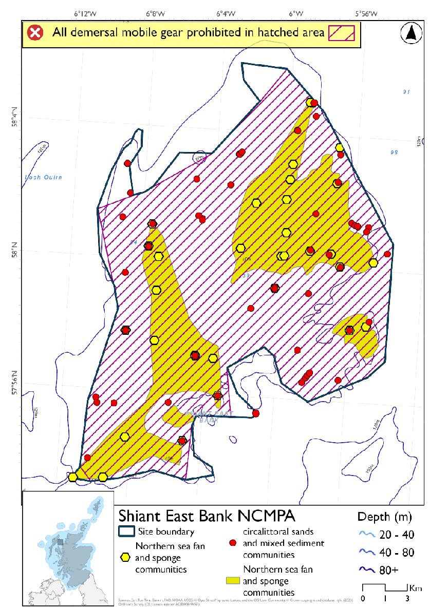
*This site will have static measures that may apply from the overlapping portion of the Inner Hebrides and the Minches SAC. These are not shown on the map but will prohibit set nets (not including fyke nets) from the whole site.
Option 2*
- Full site closure to all demersal mobile gear (demersal trawls and seines, beam trawl, mechanical dredge and hydraulic dredge).
Figure 112. Map of measures proposed under option 2:

*The measures for Option 2 proposals only come from gear types prohibited in non-overlapping areas. Overlapping restrictions may still apply from overlapping sites or areas dependent on the decisions taken for that site or area.
Overlapping sites included in this consultation
This SPA overlaps with the Inner Hebrides and the Minches SAC.
|
Socio-Economic Impact |
Option 1 |
Option 2 |
|---|---|---|
|
Average annual loss in value of landings (£000s, 2022 prices) |
0 - 15.2 |
0 - 18 |
|
Direct + indirect reduction in GVA (PV) impact (£000s) 20 years |
0 - 112.9 |
0 - 133.3 |
|
Average (mean) number of direct + indirect jobs (year on year, over 20 years), Full Time Equivalents |
0 - 0.2 |
0 - 0.2 |
|
Environmental Impact |
Option 1 |
Option 2 |
|---|---|---|
|
Benefits within the sites/areas |
Major beneficial |
Major beneficial |
|
Spill over benefits |
Negligible beneficial |
Negligible beneficial |
|
Displacement effects |
Negligible adverse |
Negligible adverse |
|
Effects from other gear types |
Negligible adverse |
Negligible adverse |
|
Estimated overall environmental impact |
Benefit |
Benefit |
18.4. Site: Loch nam Madadh SAC
Protected features:
- Intertidal mudflats and sandflats
- Lagoons
- Large shallow inlets and bays
- Otter
- Reefs
- Subtidal sandbanks
Otter is not discussed further as they are not a protected feature for which fisheries management measures are required.
Feature conditions:
- Intertidal mudflats and sandflats - Favourable
- Lagoons - Favourable
- Large shallow inlets and bays – Favourable
- Reefs - Favourable
- Subtidal sandbanks – Favourable
Conservation objectives:
- Intertidal mudflats and sandflats - Maintain
- Lagoons - Maintain
- Large shallow inlets and bays – Maintain
- Reefs - Maintain
- Subtidal sandbanks – Maintain
Conservation objectives:
- Intertidal mudflats and sandflats - Maintain
- Lagoons - Maintain
- Reefs - Maintain
- Shallow inlets and bays - Maintain
- Subtidal sandbanks – Maintain
The proposed management measures for Loch nam Madadh SAC are as follows:
Option 1:*
- Demersal trawl and seine, beam trawl, mechanical dredges and hydraulic dredges prohibited in part of the site.
Figure 113. Map of measures proposed under option 1:

* This site will have static measures that may apply in part of the site from the overlapping portion of the Inner Hebrides and the Minches SAC. These are not shown on the map for this option but will prohibit set nets (not including fyke nets).
Please check the Option 1 overlapping site map to see proposed set net measures under Option 1.
Option 2:*
- Full site closure to demersal trawl and seine, beam trawl, mechanical dredge and hydraulic dredge.
Figure 114. Map of measures proposed under option 2:

*The measures for Option 2 proposals only come from gear types prohibited in non-overlapping areas. Overlapping restrictions may still apply from overlapping sites or areas dependent on the decisions taken for that site or area.
Overlapping sites included in this consultation
This SAC overlaps with the Sea of the Hebrides NCMPA.
|
Socio-Economic Impact |
Option 1 |
Option 2 |
|---|---|---|
|
Average annual loss in value of landings (£000s, 2022 prices) |
0 - 1.6 |
0 - 2 |
|
Direct + indirect reduction in GVA (PV) impact (£000s) 20 years |
0 - 11.7 |
0 - 14.8 |
|
Average (mean) number of direct + indirect jobs (year on year, over 20 years), Full Time Equivalents |
0 - 0 |
0 - 0 |
|
Environmental Impact |
Option 1 |
Option 2 |
|---|---|---|
|
Benefits within the sites/areas |
Major beneficial |
Major beneficial |
|
Spill over benefits |
Negligible beneficial |
Negligible beneficial |
|
Displacement effects |
Negligible adverse |
Negligible adverse |
|
Effects from other gear types |
Negligible adverse |
Negligible adverse |
|
Estimated overall environmental impact |
Benefit |
Benefit |
18.5. Site: North Rona SAC
Protected features:
- Grey seal
- Reefs
- Sea caves; and
- Vegetated sea cliffs
Sea caves and vegetated sea cliffs are not discussed further as they are not protected features for which fisheries management measures are required.
Feature conditions:
- Grey seals - Unfavourable
- Reefs - Favourable
Conservation objectives:
- Grey seals - Restore
- Reefs - Maintain
The proposed management measure for North Rona SAC is as follows:
Single Proposed Management Option:
- Full site closure to demersal trawl and seine, beam trawl, pelagic seine (including ring-nets), set nets (including fyke nets), mechanical dredge and hydraulic dredge
- Longlines (until technical measures come into force) prohibited from overlap with the North Rona and Sula Sgeir SPA
Figure 115. Map of measures proposed:

A full site level of protection from the specified gear has been identified as the only suitable option in enabling the achievement of the desired level of protection for the feature in question.
Overlapping sites included in this consultation
This SAC overlaps with the North Rona and Sula Sgeir SPA.
Estimated Socio-economic impacts of proposed measures for North Rona SAC
No socio-economic impacts are anticipated for this site, based on available data in relation to:
- Average annual loss in value of landings (£000s, 2022 prices)
- Direct + indirect reduction in GVA (PV) impact (£000s) 20 years
- Average (mean) number of direct + indirect jobs (year on year, over 20 years), Full Time Equivalents
|
Environmental Impact |
Single Proposed Management Option |
|---|---|
|
Benefits within the sites/areas |
Minor beneficial |
|
Spill over benefits |
None |
|
Displacement effects |
None |
|
Effects from other gear types |
None |
|
Estimated overall environmental impact |
Benefit |
18.6. Site: Sound of Barra SAC
Protected features:
- Harbour seal
- Reefs
- Subtidal sandbanks
Feature conditions:
- Harbour seal – Favourable
- Reefs - Favourable
- Subtidal sandbanks – Unfavourable
Conservation objectives:
- Harbour seal - Maintain
- Reefs - Maintain
- Subtidal sandbanks – Restore
The proposed management measure for Sound of Barra SAC is as follows:
Single Proposed Management Option:
- Demersal trawl and seine, beam trawl, set nets (including fyke nets), pelagic seine (including ring-nets), mechanical dredge and hydraulic dredge prohibited.
Figure 116. Map of measures proposed:

A full site level of protection from the specified gear has been identified as the only suitable option in enabling the achievement of the desired level of protection for the feature in question.
Overlapping sites included in this consultation
This SAC overlaps with the West Coast of the Outer Hebrides SPA.
|
Socio-Economic Impact |
Single Proposed Management Option |
|---|---|
|
Average annual loss in value of landings (£000s, 2022 prices) |
93.6 - 115.4 |
|
Direct + indirect reduction in GVA (PV) impact (£000s) 20 years |
693.3 - 852.6 |
|
Average (mean) number of direct + indirect jobs (year on year, over 20 years), Full Time Equivalents |
1.1 - 1.3 |
|
Environmental Impact |
Single Proposed Management Option |
|---|---|
|
Benefits within the sites/areas |
Major beneficial |
|
Spill over benefits |
Minor beneficial |
|
Displacement effects |
Negligible adverse |
|
Effects from other gear types |
Minor adverse |
|
Estimated overall environmental impact |
Benefit |
18.7. Site: Flannan Isles SPA
Protected features:
- Fulmar – breeding
- Guillemot – breeding
- Kittiwake – breeding
- Leach’s petrel – breeding
- Puffin – breeding
- Razorbill – breeding
Feature conditions:
- Fulmar - Unfavourable
- Guillemot - Unfavourable
- Kittiwake - Unfavourable
- Leach's petrel - Unfavourable
- Puffin - Favourable
- Razorbill - Unfavourable
Conservation objectives:
- Fulmar – Restore
- Guillemot – Restore
- Kittiwake – Restore
- Leach’s petrel – Restore
- Puffin – Maintain
- Razorbill – Restore
The proposed management measures for Flannan Isles SPA are as follows:
Option 1:
- Set nets (including fyke nets) prohibited from February till end of August in areas down to 177m based on presence and maximum dive depth for guillemot.
- Full site closure to longlines (until technical measures come into force) and hydraulic dredge.
Figure 117. Map of measures proposed under option 1:

Option 2:
- Full site closure to longlines (until technical measures come into force), set nets (including fyke nets) and hydraulic dredge.
Figure 118. Map of measures proposed under option 2:

Estimated Socio-economic impacts of proposed measures for Flannan Isles SPA
No socio-economic impacts are anticipated for this site, based on available data in relation to:
- Average annual loss in value of landings (£000s, 2022 prices)
- Direct + indirect reduction in GVA (PV) impact (£000s) 20 years
- Average (mean) number of direct + indirect jobs (year on year, over 20 years), Full Time Equivalents
|
Environmental Impact |
Option 1 |
Option 2 |
|---|---|---|
|
Benefits within the sites/areas |
Moderate beneficial |
Moderate beneficial |
|
Spill over benefits |
None |
None |
|
Displacement effects |
None |
None |
|
Effects from other gear types |
None |
None |
|
Estimated overall environmental impact |
Benefit |
Benefit |
18.8. Site: Mingulay and Berneray SPA
Protected features:
- Fulmar – breeding
- Guillemot – breeding
- Kittiwake – breeding
- Puffin – breeding
- Razorbill – breeding
- Shag - breeding
Feature conditions:
- Fulmar - Unfavourable
- Guillemot - Favourable
- Kittiwake - Unfavourable
- Puffin - Unfavourable
- Razorbill - Favourable
- Shag - Unfavourable
Conservation objectives:
- Fulmar – Restore
- Guillemot – Maintain
- Kittiwake – Restore
- Puffin – Restore
- Razorbill – Maintain
- Shag - Restore
NatureScot provided amalgamated season advice for this site but individual seasonality for species has been used to develop consultation options.
The proposed management measure for Mingulay and Berneray SPA is as follows:
Single Proposed Management Option:*
- Full site closure to longlines (until technical measures come into force) and hydraulic dredge
- Set nets (including fyke nets) prohibited in areas down to 65m (covers full site based on presence and maximum dive depth for shag. As shag are present all year this and site is shallower than other protected features maximum dive depths these do not need considered)
Figure 119. Map of measures proposed:

A full site level of protection from the specified gear has been identified as the only suitable option in enabling the achievement of the desired level of protection for the feature in question.
Overlapping sites included in this consultation
This SPA overlaps with the Sea of the Hebrides NCMPA.
Estimated Socio-economic impacts of proposed measures for Mingulay and Berneray SPA
No socio-economic impacts are anticipated for this site, based on available data in relation to:
- Average annual loss in value of landings (£000s, 2022 prices)
- Direct + indirect reduction in GVA (PV) impact (£000s) 20 years
- Average (mean) number of direct + indirect jobs (year on year, over 20 years), Full Time Equivalents
|
Environmental Impact |
Single Proposed Management Option |
|---|---|
|
Benefits within the sites/areas |
Moderate beneficial |
|
Spill over benefits |
None |
|
Displacement effects |
None |
|
Effects from other gear types |
None |
|
Estimated overall environmental impact |
Benefit |
18.9. Site: North Rona and Sula Sgeir SPA
Protected features:
- Fulmar – breeding
- Gannet – breeding
- Great black-backed gull – breeding
- Guillemot – breeding
- Kittiwake – breeding
- Leach’s petrel – breeding
- Puffin – breeding
- Razorbill – breeding
- Storm petrel - breeding
Feature conditions:
- Fulmar - Unfavourable
- Gannet - Favourable
- Great black-backed gull - Unfavourable
- Guillemot - Unfavourable
- Kittiwake - Unfavourable
- Leach's petrel - Unfavourable
- Puffin - Unfavourable
- Razorbill - Unfavourable
- Storm petrel - Favourable
Conservation objectives:
- Fulmar - Restore
- Gannet - Maintain
- Great black-backed gull - Restore
- Guillemot - Restore
- Kittiwake - Restore
- Leach's petrel - Restore
- Puffin - Restore
- Razorbill – Restore
- Storm petrel - Maintain
NatureScot provided amalgamated season advice for this site but individual seasonality for species has been used to develop consultation options.
The proposed management measures for North Rona and Sula Sgeir SPA are as follows:
Option 1:
- Set nets (including fyke nets) prohibited February till end of September in areas shallower than 34m based on presence and maximum dive depth for gannet
- Demersal set nets (including fyke nets) prohibited February till end of August and pelagic set nets prohibited February till end of September based on presence of guillemot and gannet and maximum dive depth for guillemot and gannet and maximum dive depth for guillemot in areas deeper than 34m but shallower than 177m
- Set nets (including fyke nets) and pelagic seines (including ring-nets) prohibited in part of the site that overlaps with the North Rona SAC
- Full site closure to longlines (until technical measures come into force) and hydraulic dredge
Figure 120. Map of measures proposed under option 1:

Option 2:*
- Full site closure to longlines (until technical measures come into force), set nets (including fyke nets) and hydraulic dredge.
Figure 121. Map of measures proposed under option 2:

*The measures for Option 2 proposals only come from gear types prohibited in non-overlapping areas. Overlapping restrictions may still apply from overlapping sites or areas dependent on the decisions taken for that site or area.
Overlapping sites included in this consultation
This SPA overlaps with the North Rona SAC.
Estimated Socio-economic impacts of proposed measures for North Rona and Sula Sgeir SPA
No socio-economic impacts are anticipated for this site, based on available data in relation to:
- Average annual loss in value of landings (£000s, 2022 prices)
- Direct + indirect reduction in GVA (PV) impact (£000s) 20 years
- Average (mean) number of direct + indirect jobs (year on year, over 20 years), Full Time Equivalents
|
Environmental Impact |
Option 1 |
Option 2 |
|---|---|---|
|
Benefits within the sites/areas |
Moderate beneficial |
Moderate beneficial |
|
Spill over benefits |
None |
None |
|
Displacement effects |
None |
None |
|
Effects from other gear types |
None |
None |
|
Estimated overall environmental impact |
Benefit |
Benefit |
18.10. Site: Seas off St Kilda SPA
Protected features:
- Fulmar - Breeding
- Gannet - Breeding
- Guillemot - Breeding
- Puffin - Breeding
- Storm petrel – Breeding
Feature conditions:
- Fulmar - Unfavourable
- Gannet - Favourable
- Guillemot - Unfavourable
- Puffin - Unfavourable
- Storm petrel - Favourable
Conservation objectives:
- Fulmar - Restore
- Gannet - Maintain
- Guillemot - Restore
- Puffin - Restore
- Storm petrel – Maintain
NatureScot provided amalgamated season advice for this site but individual seasonality for species has been used to develop consultation options.
The proposed management measures for Seas off St Kilda SPA are as follows:
Option 1:
- Demersal set nets (including fyke nets) prohibited between February and end of August and pelagic set nets prohibited February till end of September in areas down to 177m based on presence of guillemot and gannet and maximum dive depth for guillemot.
- Pelagic set nets prohibited February till end of September in areas deeper than 177m based on presence of guillemot and gannet
- Full site closure to longlines (until technical measures come into force) and hydraulic dredge.
Figure 122. Map of measures proposed under option 1:

Option 2:
- Full site closure to longlines (until technical measures come into force), set nets (including fyke nets) and hydraulic dredge.
Figure 123. Map of measures proposed under option 2:

|
Socio-Economic Impact |
Option 1 |
Option 2 |
|---|---|---|
|
Average annual loss in value of landings (£000s, 2022 prices) |
244.9 - 244.9 |
244.9 - 244.9 |
|
Direct + indirect reduction in GVA (PV) impact (£000s) 20 years |
1,676.1 - 1,676.1 |
1,676.1 - 1,676.1 |
|
Average (mean) number of direct + indirect jobs (year on year, over 20 years), Full Time Equivalents |
2.8 - 2.8 |
2.8 - 2.8 |
|
Environmental Impact |
Option 1 |
Option 2 |
|---|---|---|
|
Benefits within the sites/areas |
Major beneficial |
Major beneficial |
|
Spill over benefits |
Negligible beneficial |
Negligible beneficial |
|
Displacement effects |
Negligible adverse |
Negligible adverse |
|
Effects from other gear types |
Minor adverse |
Minor adverse |
|
Estimated overall environmental impact |
Benefit |
Benefit |
18.11. Site: Shiant Isles SPA
Protected features:
- Fulmar – breeding
- Greenland barnacle goose – non-breeding
- Guillemot – breeding
- Kittiwake – breeding
- Puffin – breeding
- Razorbill – breeding
- Shag – breeding
Greenland barnacle goose is not discussed further as they are not a protected feature for which fisheries management measures are required.
Feature conditions:
- Fulmar – Unfavourable
- Guillemot – Unfavourable
- Kittiwake – Unfavourable
- Puffin – Favourable
- Razorbill – Favourable
- Shag – Unfavourable
Conservation objectives:
- Fulmar – Restore
- Guillemot – Restore
- Kittiwake – Restore
- Puffin – Maintain
- Razorbill – Maintain
- Shag – Restore
NatureScot provided amalgamated season advice for this site but individual seasonality for species has been used to develop consultation options.
The proposed management measures for Shiant Isles SPA are as follows:
Option 1:
- Set nets (including fyke nets) prohibited in areas shallower than 64.5m based on presence and maximum dive depth for shag
- Demersal set nets (including fyke nets) prohibited from February till end of August and pelagic set nets prohibited in areas deeper than 64.5m but shallower than 177m based on presence of guillemot and shag and maximum dive depth of guillemot.
- Full site closure to longlines (until technical measures come into force) and hydraulic dredge
Figure 124. Map of measures proposed under option 1:

Option 2:
- Full site closure to longlines (until technical measures come into force), set nets (including fyke nets), and hydraulic dredge.
Figure 125. Map of measures proposed under option 2:

Overlapping sites included in this consultation
This SPA overlaps with the Inner Hebrides and the Minches SAC.
Estimated Socio-economic impacts of proposed measures for Shiant Isles SPA
No socio-economic impacts are anticipated for this site, based on available data in relation to:
- Average annual loss in value of landings (£000s, 2022 prices)
- Direct + indirect reduction in GVA (PV) impact (£000s) 20 years
- Average (mean) number of direct + indirect jobs (year on year, over 20 years), Full Time Equivalents
|
Environmental Impact |
Option 1 |
Option 2 |
|
Benefits within the sites/areas |
Moderate beneficial |
Moderate beneficial |
|
Spill over benefits |
None |
None |
|
Displacement effects |
None |
None |
|
Effects from other gear types |
None |
None |
|
Estimated overall environmental impact |
Benefit |
Benefit |
Contact
Email: marine_biodiversity@gov.scot