
Fisheries Management Measures within Scottish Inshore Marine Protected Areas (MPAs) and Proposed Priority Marine Feature (PMF) Management Areas - High level Site Summary Details and Potential Impacts of Proposed Fisheries Management Measures
Overview of site and area details and potential impacts of the proposed fisheries management measures within Scottish Inshore Marine Protected Areas (MPAs) and proposed Priority Marine Feature (PMF) management areas

12. Moray Firth Scottish Marine Region MPAs
Due to the complexity and large number of areas and sites, ecosystem services data has been produced at a regional level, allowing for a more consistent assessment across wider geographical scales while still capturing key variations in ecological, social, and economic value.
|
Total value of changes in ecosystem services |
Option 1 Min |
Option 1 Max |
Option 2 Min |
Option 2 Max |
|---|---|---|---|---|
|
Benefits |
Moderate |
Moderate |
High |
High |
|
Costs |
Minimal |
Low |
Very High Potential to displace negative ES effects |
Very High |
|
Net Impacts |
Low Benefit |
Low Benefit |
Moderate Cost |
Moderate Cost |
12.1. Site: Southern Trench NCMPA
Protected features:
- Burrowed mud
- Fronts
- Minke whale
- Quaternary of Scotland
- Shelf deeps
- Submarine Mass Movement
Fronts, shelf deeps, Quaternary of Scotland and submarine mass movement are not discussed further as they are not a protected feature for which fisheries management measures are required.
Feature conditions:
- Burrowed mud - Favourable
- Minke whale - Favourable
Conservation objectives:
- Burrowed mud - Conserve
- Minke whale - Conserve
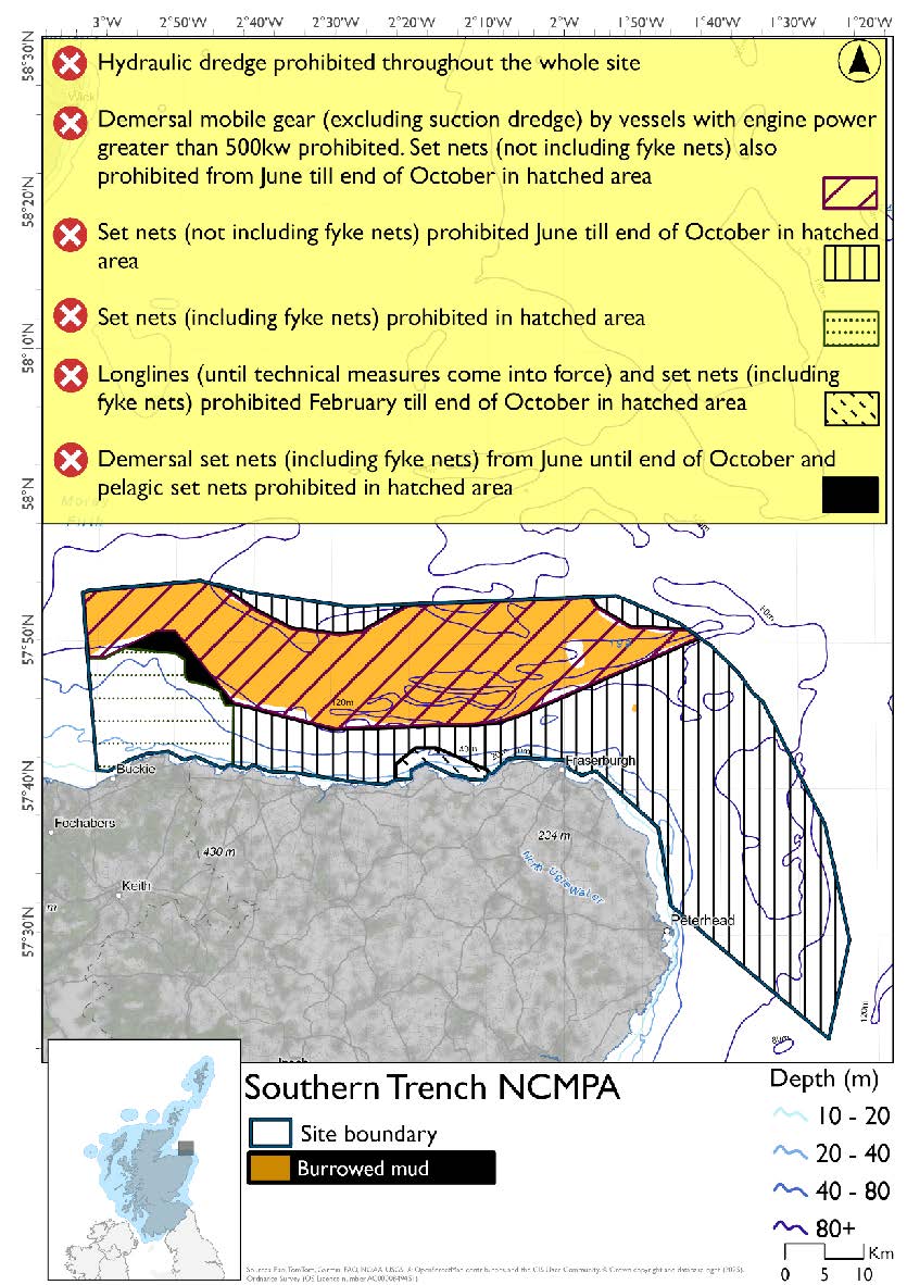
The proposed management measures for Southern Trench NCMPA are as follows:
Option 1:
- Demersal trawls, demersal seine nets, beam trawls and mechanical dredge prohibited by vessels with engine power greater than 500kw in burrowed mud part of the site
- Set nets prohibited from June till end of October (not including fyke nets) in part of the site that doesn’t overlap with any other site
- Set nets (including fyke nets) prohibited in overlapping portion with the Moray Firth SPA that’s shallower than 64.5m
- Demersal set nets (including fyke nets) prohibited from June till end of October and pelagic set nets prohibited in part of the site that overlaps with the Moray Firth SPA that’s deeper than 64.5m
- Longlines (until technical measures come into force) and set nets (including fyke nets) from February till end of October prohibited in part of the site that overlaps with the Troup, Pennan and Lion’s Heads SPA
- Full site closure to hydraulic dredge
Figure 54. Map of measures proposed under option 1:
Option 2*
- Full site closure to demersal mobile gears (demersal trawls, demersal seine nets, beam trawls, mechanical dredge and hydraulic dredge) and set nets (not including fyke nets)
Figure 55. Map of measures proposed under option 2:
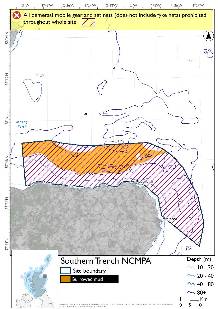
*The measures for Option 2 proposals only come from gear types prohibited in non-overlapping areas. Overlapping restrictions may still apply from overlapping sites or areas dependent on the decisions taken for that site or area.
Overlapping sites included in this consultation
This NCMPA overlaps with the Moray Firth SPA and Troup, Pennan and Lion’s Head SPA.
|
Socio-Economic Impact |
Option 1 |
Option 2 |
|---|---|---|
|
Average annual loss in value of landings (£000s, 2022 prices) |
2.1 - 150.6 |
5,433.8 - 5,433.8 |
|
Direct + indirect reduction in GVA (PV) impact (£000s) 20 years |
1.9 - 1,052.9 |
38,479.7 - 38,479.7 |
|
Average (mean) number of direct + indirect jobs (year on year, over 20 years), Full Time Equivalents |
0 - 1.7 |
61.6 - 61.6 |
|
Environmental Impact |
Option 1 |
Option 2 |
|---|---|---|
|
Benefits within the sites/areas |
Major beneficial |
Major beneficial |
|
Spill over benefits |
Negligible beneficial |
Moderate beneficial |
|
Displacement effects |
Negligible adverse |
Moderate adverse |
|
Effects from other gear types |
Negligible adverse |
Minor adverse |
|
Estimated overall environmental impact |
Benefit |
Benefit |
12.2. Site: East Caithness Cliffs NCMPA and East Caithness Cliffs SPA
Protected features:
NCMPA:
- Black guillemot - breeding and non-breeding.
SPA:
- Cormorant - breeding
- Fulmar - breeding
- Great black-backed gull - breeding
- Guillemot - breeding
- Herring gull - breeding
- Kittiwake - breeding
- Peregrine - breeding
- Razorbill - breeding
- Shag – breeding
Peregrine are not discussed further as they are not a protected feature for which fisheries management measures are required.
Feature conditions:
NCMPA:
- Black guillemot – Unfavourable
SPA:
- Cormorant - Unfavourable
- Fulmar - Favourable
- Great black-backed gull - Unfavourable
- Guillemot - Favourable
- Herring gull - Unfavourable
- Kittiwake - Favourable
- Razorbill - Favourable
- Shag - Unfavourable
Conservation objectives:
NCMPA:
- Black guillemot – Recover
SPA:
- Cormorant - Restore
- Fulmar - Maintain
- Great black-backed gull - Restore
- Guillemot - Maintain
- Herring gull - Restore
- Kittiwake - Maintain
- Razorbill - Maintain
- Shag - Restore
The proposed management measure for East Caithness Cliffs NCMPA and SPA is as follows:
Single Proposed Management Option:
- Full site closure to longlines (until technical measures come into force), set nets (including fyke nets) and hydraulic dredge.
Figure 56. Map of measures proposed:
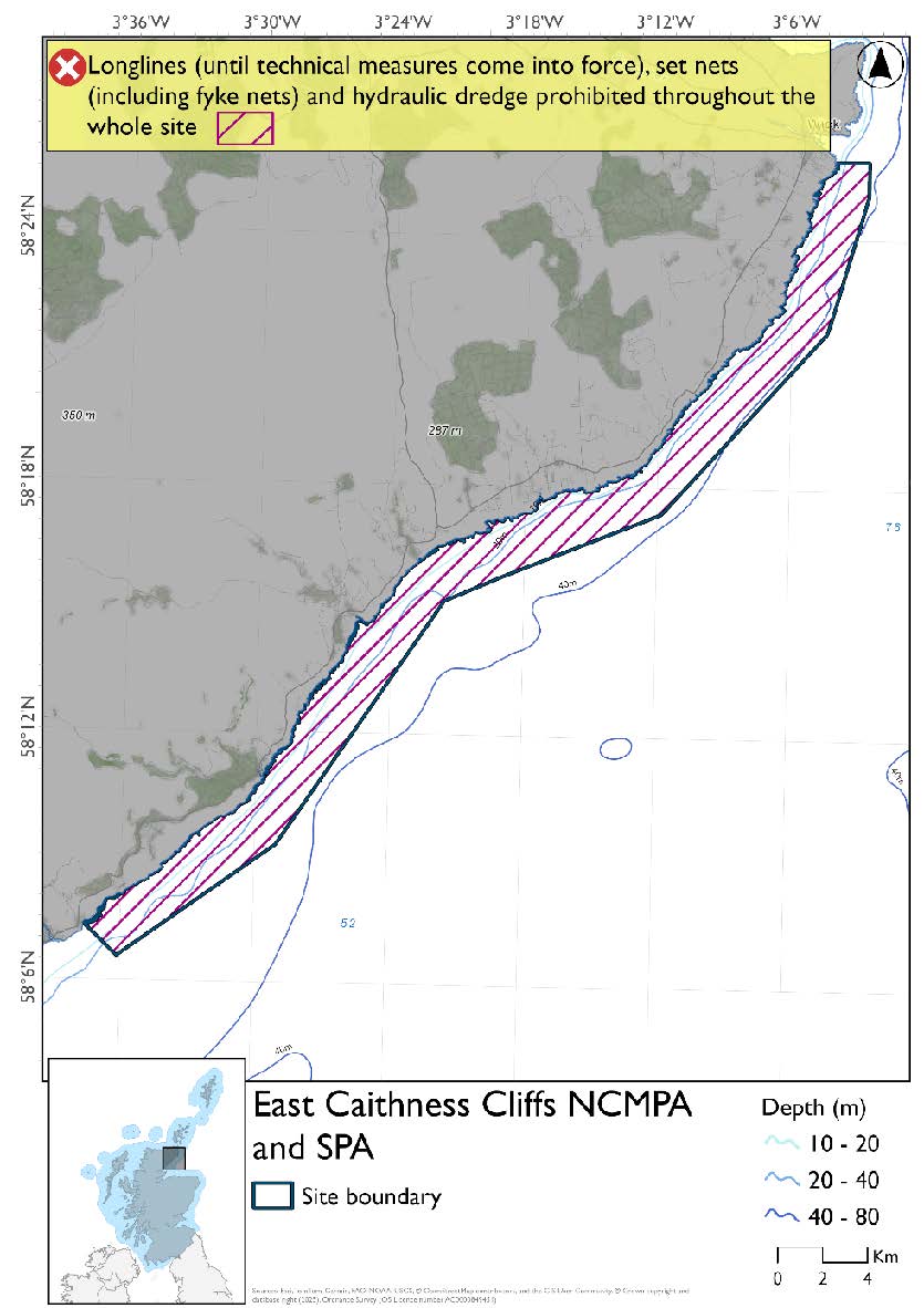
A full site level of protection from the specified gear has been identified as the only suitable option in enabling the achievement of the desired level of protection for the feature in question.
Overlapping sites included in this consultation
This NCMPA and SPA overlaps with the Moray Firth SPA
Estimated Socio-economic impacts of proposed measures for East Caithness Cliffs NCMPA and East Caithness Cliffs SPA
No socio-economic impacts are anticipated for this site, based on available data in relation to:
- Average annual loss in value of landings (£000s, 2022 prices)
- Direct + indirect reduction in GVA (PV) impact (£000s) 20 years
- Average (mean) number of direct + indirect jobs (year on year, over 20 years), Full Time Equivalents
|
Environmental Impact |
Single Proposed Management Option |
|---|---|
|
Benefits within the sites/areas |
Moderate beneficial |
|
Spill over benefits |
None |
|
Displacement effects |
None |
|
Effects from other gear types |
None |
|
Estimated overall environmental impact |
Benefit |
12.3. Site: Dornoch Firth and Morrich More SAC and Moray Firth SAC
Protected features:
Dornoch Firth and Morrich More SAC:
- Estuaries
- Harbour Seal
- Intertidal mudflats and Sandflats
- Reefs
- Otter
- Subtidal sandbanks
Moray Firth SAC:
- Bottlenose dolphin
- Subtidal sandbanks
Otter is not discussed further as they are not a protected feature for which fisheries management measures are required.
Feature conditions:
Dornoch Firth and Morrich More SAC:
- Estuaries - Not Assessed
- Harbour Seal - Unfavourable
- Intertidal mudflats and Sandflats - Favourable
- Reefs - Unfavourable
- Subtidal sandbanks – Favourable
Moray Firth SAC:
- Bottlenose dolphin - Favourable
- Subtidal sandbanks - Favourable
Conservation objectives:
Dornoch Firth and Morrich More SAC:
- Estuaries - Maintain
- Harbour Seal - Restore
- Intertidal mudflats and Sandflats - Maintain
- Reefs - Restore
- Subtidal sandbanks – Maintain
Moray Firth SAC:
- Bottlenose dolphin - Maintain
- Subtidal sandbanks - Maintain
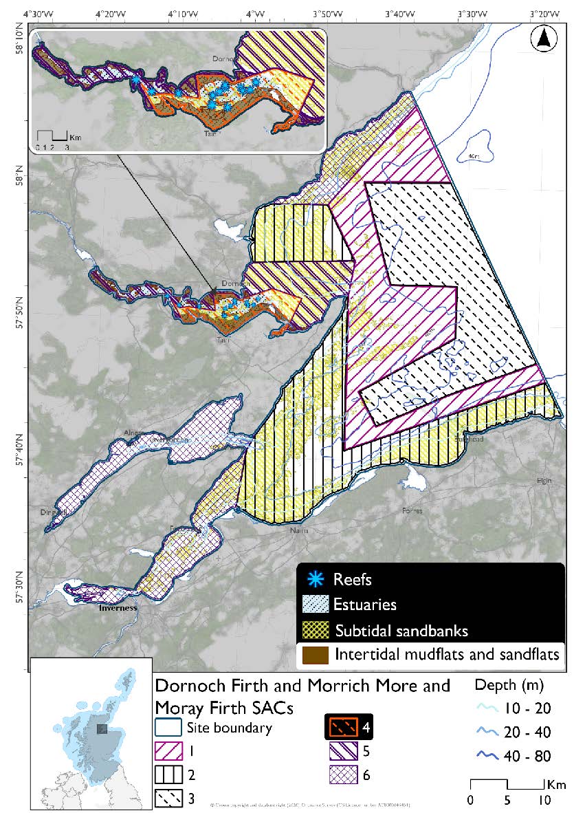
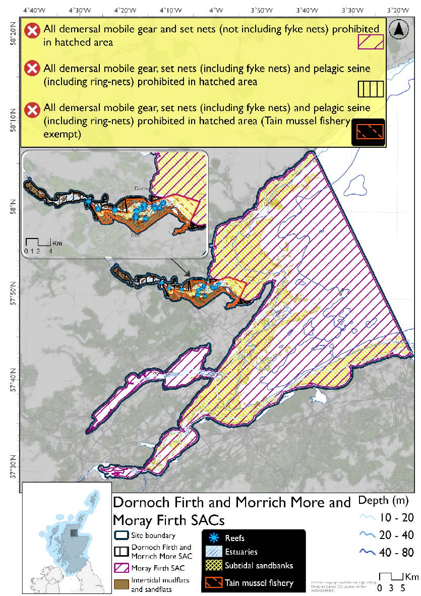
- Demersal trawl, demersal seine net, beam trawl, mechanical dredge, hydraulic dredge, pelagic seine (including ring-nets) and set nets (including fyke nets) prohibited (Hatching 5)
The proposed management measures for Dornoch Firth and Morrich More and Moray Firth SAC are as follows:
Option 1:
- Beam trawl, set nets (including fyke nets) and hydraulic dredge prohibited (Hatching 1)
- Beam trawl, set nets (including fyke nets), mechanical dredges and hydraulic dredge prohibited (Hatching 2)
- Beam trawl, set nets (not including fyke nets) and hydraulic dredge prohibited (Hatching 3)
- Demersal trawl, demersal seine net, beam trawl, mechanical dredge, hydraulic dredge, set nets (including fyke nets) and pelagic seine (including ring-nets) prohibited (Tain Mussel Fishery exempt) (Hatching 4)
- Demersal trawl, demersal seine net, beam trawl, set nets (including fyke nets), mechanical dredges and hydraulic dredge prohibited (Hatching 6)
Figure 57. Map of measures proposed under option 1:
Option 2*
- Full site closure for both SACs to hydraulic dredge, demersal trawls and seine, beam trawl and mechanical dredge. (Tain mussel fishery exempt)
- Full site closure to set nets (including fyke nets) and pelagic seine (including ring-nets) for Dornoch Firth and Morrich More SAC
- Full site closure to set nets (not including fyke nets) for Moray Firth SAC
Figure 58. Map of measures proposed under option 2:
*The measures for Option 2 proposals only come from gear types prohibited in non-overlapping areas. Overlapping restrictions may still apply from overlapping sites or areas dependent on the decisions taken for that site or area.
Overlapping sites included in this consultation
These SACs overlap with the Moray Firth SPA.
|
Socio-Economic Impact |
Option 1 |
Option 2 |
|---|---|---|
|
Average annual loss in value of landings (£000s, 2022 prices) |
0.8 - 33.4 |
1,974.2 - 1,974.2 |
|
Direct + indirect reduction in GVA (PV) impact (£000s) 20 years |
6.3 - 247.1 |
14,513.9 - 14,514.2 |
|
Average (mean) number of direct + indirect jobs (year on year, over 20 years), Full Time Equivalents |
0 - 0.4 |
22.4 - 22.4 |
|
Environmental Impact |
Option 1 |
Option 2 |
|---|---|---|
|
Benefits within the sites/areas |
Moderate beneficial |
Major beneficial |
|
Spill over benefits |
Negligible beneficial |
Minor beneficial |
|
Displacement effects |
Negligible adverse |
Minor adverse |
|
Effects from other gear types |
Negligible adverse |
Minor adverse |
|
Estimated overall environmental impact |
Benefit |
Benefit |
12.4. Site: Moray Firth SPA
Protected features:
- Common scoter - non-breeding
- Eider - non-breeding
- Goldeneye - non-breeding
- Great northern diver - non-breeding
- Long-tailed duck - non-breeding
- Red-breasted merganser - non-breeding
- Red-throated diver - non-breeding
- Scaup - non-breeding
- Shag – breeding and non-breeding
- Slavonian grebe - non-breeding
- Velvet scoter - non-breeding
Feature conditions:
- Common scoter - Favourable
- Eider - Favourable
- Goldeneye - Favourable
- Great northern diver - Favourable
- Long-tailed duck - Favourable
- Red-breasted merganser - Favourable
- Red-throated diver - Favourable
- Scaup - Favourable
- Shag – unfavourable at breeding colony SPA, Favourable in non-breeding season
- Slavonian grebe - Favourable
- Velvet scoter - Favourable
Conservation objectives:
- Common scoter - Maintain
- Eider - Maintain
- Goldeneye - Maintain
- Great northern diver - Maintain
- Long-tailed duck - Maintain
- Red-breasted merganser - Maintain
- Red-throated diver - Maintain
- Scaup - Maintain
- Shag - Restore
- Slavonian grebe - Maintain
- Velvet scoter - Maintain
The proposed management measures for Moray Firth SPA are as follows:
Option 1:*
- Set nets (including fyke nets) prohibited in areas down to 64.5m and pelagic set nets prohibited in areas deeper than 64.5m based on presence and maximum dive depth of shag
- Longlines (until technical measures come into force) prohibited in part of the site that overlaps with the East Caithness Cliffs SPA
- Pelagic seine (including ring-nets) prohibited in part of the site that overlaps with the Dornoch Firth and Morrich More SAC
- Demersal set nets (not including fyke nets) prohibited from June till end of October and pelagic set nets prohibited in overlapping area with Southern Trench NCMPA deeper than 64.5m based on presence and maximum dive depth of shag and static net seasonal measures for minke whale from the NCMPA
- Full site closure to hydraulic dredge
Figure 59. Map of measures proposed under option 1:
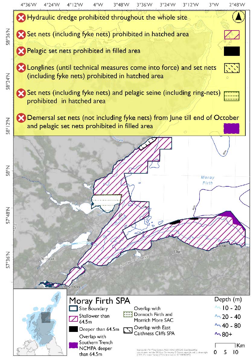
*This site will have other demersal mobile measures that may apply from the overlapping portions with the Dornoch Firth and Morrich More and Moray Firth SACs that aren’t shown on the map for this option.
- Dornoch Firth and Morrich More SAC would prohibit demersal trawls and seines, beam trawls and mechanical dredge in the overlapping areas. Mechanical dredge exempt in Tain Mussel Fishery.
- Moray Firth SAC has zoned areas so demersal trawls and seines, beam trawls and mechanical dredge could be prohibited in overlapping areas.
Please check the Option 1 overlapping site map to see proposed demersal mobile measures under Option 1.
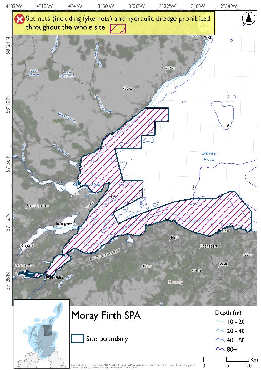
Option 2:*
- Full site closure to set nets (including fyke nets) and hydraulic dredge.
Figure 60. Map of measures proposed under option 2:
*The measures for Option 2 proposals only come from gear types prohibited in non-overlapping areas. Overlapping restrictions may still apply from overlapping sites or areas dependent on the decisions taken for that site or area.
Overlapping sites included in this consultation
This SPA overlaps with the East Caithness Cliffs and Southern Trench NCMPAs Dornoch Firth and Morrich More and Moray Firth SACs and East Caithness Cliffs SPA.
Estimated Socio-economic impacts of proposed measures for Moray Firth SPA
No socio-economic impacts are anticipated for this site, based on available data in relation to:
- Average annual loss in value of landings (£000s, 2022 prices)
- Direct + indirect reduction in GVA (PV) impact (£000s) 20 years
- Average (mean) number of direct + indirect jobs (year on year, over 20 years), Full Time Equivalents
|
Environmental Impact |
Option 1 |
Option 2 |
|---|---|---|
|
Benefits within the sites/areas |
Major beneficial |
Major beneficial |
|
Spill over benefits |
None |
None |
|
Displacement effects |
None |
None |
|
Effects from other gear types |
None |
None |
|
Estimated overall environmental impact |
Major benefit |
Major benefit |
12.5. Site: Troup, Pennan and Lion`s Heads SPA
Protected features:
- Fulmar - breeding
- Guillemot - breeding
- Herring gull - breeding
- Kittiwake - breeding
- Razorbill - breeding
Feature conditions:
- Fulmar - Unfavourable
- Guillemot - Unfavourable
- Herring gull - Unfavourable
- Kittiwake - Unfavourable
- Razorbill - Favourable
Conservation objectives:
- Fulmar - Restore
- Guillemot - Restore
- Herring gull - Restore
- Kittiwake - Restore
- Razorbill - Maintain
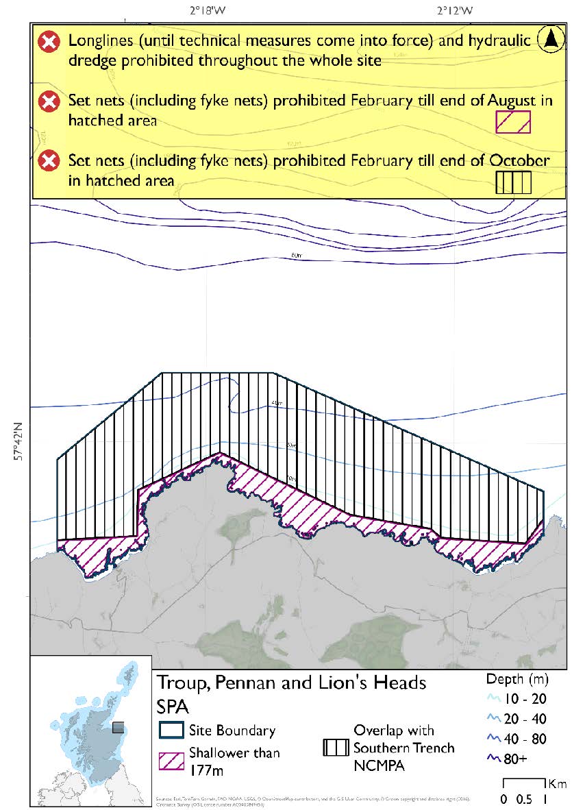
The proposed management measures for Troup, Pennan and Lion’s Head SPA are as follows:
Option 1:
- Set nets (including fyke nets) prohibited February till end of August in areas down to 177m based on presence and maximum dive depth for guillemot
- Set nets (including fyke nets) prohibited February till end of October in areas overlapping the Southern Trench NCMPA
- Full site closure to longlines (until technical measures come into force) and hydraulic dredge.
Figure 61. Map of measures proposed under option 1:
Option 2:
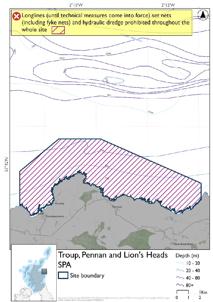
- Full site closure to longlines (until technical measures come into force), set nets (including fyke nets) and hydraulic dredge.
Figure 62. Map of measures proposed under option 2:
Overlapping sites included in this consultation
This SPA overlaps with the Southern Trench NCMPA.
Estimated Socio-economic impacts of proposed measures for Troup, Pennan and Lion`s Heads SPA
No socio-economic impacts are anticipated for this site, based on available data in relation to:
- Average annual loss in value of landings (£000s, 2022 prices)
- Direct + indirect reduction in GVA (PV) impact (£000s) 20 years
- Average (mean) number of direct + indirect jobs (year on year, over 20 years), Full Time Equivalents
|
Environmental Impact |
Option 1 |
Option 2 |
|---|---|---|
|
Benefits within the sites/areas |
Moderate beneficial |
Moderate beneficial |
|
Spill over benefits |
None |
None |
|
Displacement effects |
None |
None |
|
Effects from other gear types |
None |
None |
|
Estimated overall environmental impact |
Benefit |
Benefit |
Contact
Email: marine_biodiversity@gov.scot