
Fisheries Management Measures within Scottish Inshore Marine Protected Areas (MPAs) and Proposed Priority Marine Feature (PMF) Management Areas - High level Site Summary Details and Potential Impacts of Proposed Fisheries Management Measures
Overview of site and area details and potential impacts of the proposed fisheries management measures within Scottish Inshore Marine Protected Areas (MPAs) and proposed Priority Marine Feature (PMF) management areas

24. West Highlands Scottish Marine Region Proposed PMF Management Areas
Due to the complexity and large number of areas, the estimated socio-economic impacts of proposed measures data has been produced at a regional level, allowing for a more consistent assessment across wider geographical scales while still capturing key variations in ecological, social, and economic value. Some values may not be disclosed for confidentiality reasons, as it relates to the operations of fewer than three vessels. Sites with a proposed single management option will be option 2.
|
Socio-Economic Impact |
Option 1 |
Option 2 |
|---|---|---|
|
Average annual loss in value of landings (£000s, 2022 prices) |
11.8 - 82.6 |
20.7 - 136.6 |
|
Direct + indirect reduction in GVA (PV) impact (£000s) 20 years |
87.2 - 610.1 |
153.1 - 1,008.8 |
|
Average (mean) number of direct + indirect jobs (year on year, over 20 years), Full Time Equivalents |
0.1 - 0.9 |
0.2 - 1.5 |
|
Environmental Impact |
Option 1 |
Option 2 |
|---|---|---|
|
Benefits within the sites/areas |
Major beneficial |
Major beneficial |
|
Spill over benefits |
Negligible beneficial |
Negligible beneficial |
|
Displacement effects |
Negligible adverse |
Negligible adverse |
|
Effects from other gear types |
Negligible adverse |
Negligible adverse |
|
Estimated overall environmental impact |
Benefit |
Benefit |
24.1. Single Proposed Management Option
PMF management areas will be closed to demersal trawls and seines, beam trawls, mechanical dredges, and hydraulic dredges. This is because the features present in these areas are sensitive to these gear types. No reduced spatial alternative.
A single management option has been developed for the following 12 PMF management areas. Only one option was identified due to one of, or combination of, evidence (fishing activity or PMF related), boundary setting principles and compliance considerations.
24.1.1. Area: Loch Scavaig (Skye)
This proposed PMF management area overlaps with the Inner Hebrides and the Minches SAC.
This PMF management area overlaps with management measures being consulted on for Inner Hebrides and the Minches SAC for set nets (not including fyke nets) which are not shown in the map below.
Please check overlapping site map option(s) to see static gear measures.
Additional fishing activity data were provided and adjustments made to the 2018 area’s boundary to reduce the area as much as possible whilst maintaining adequate buffers around the PMF records.
Maerl bed records at the area boundary have not had buffers applied as these were from a 2024 survey which was only available after the area was finalised for consultation.
Feature: Maerl beds, maerl or coarse shell gravel with burrowing sea cucumbers, northern sea fan and sponge communities.
Figure 213. Map of measures proposed:

24.1.2. Area: Loch Eil (Lochaber)
Feature: Horse mussel beds
There are also intertidal blue mussel records present, but they were not considered part of this process due to there being no overlaps with bottom-contacting fisheries and intertidal mussel beds.
No additional fishing data were provided within the proposed PMF management area.
Figure 214. Map of measures proposed:

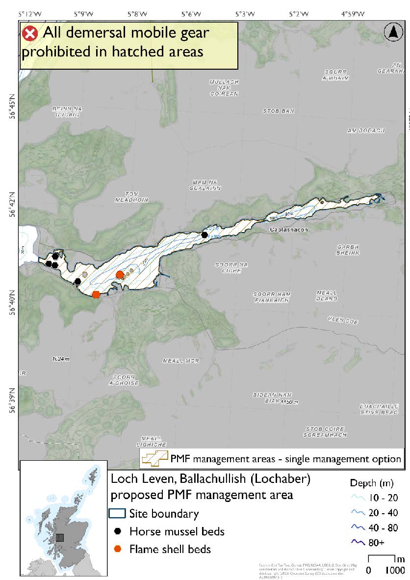
24.1.3. Area: Loch Leven, Ballachullish (Lochaber)
The boundary of the 2018 area was brought to the narrows to encompass the PMF records more closely. No additional fishing data were provided within the proposed PMF management area.
Feature: Horse mussel beds, flame shell beds
Figure 215. Map of measures proposed:
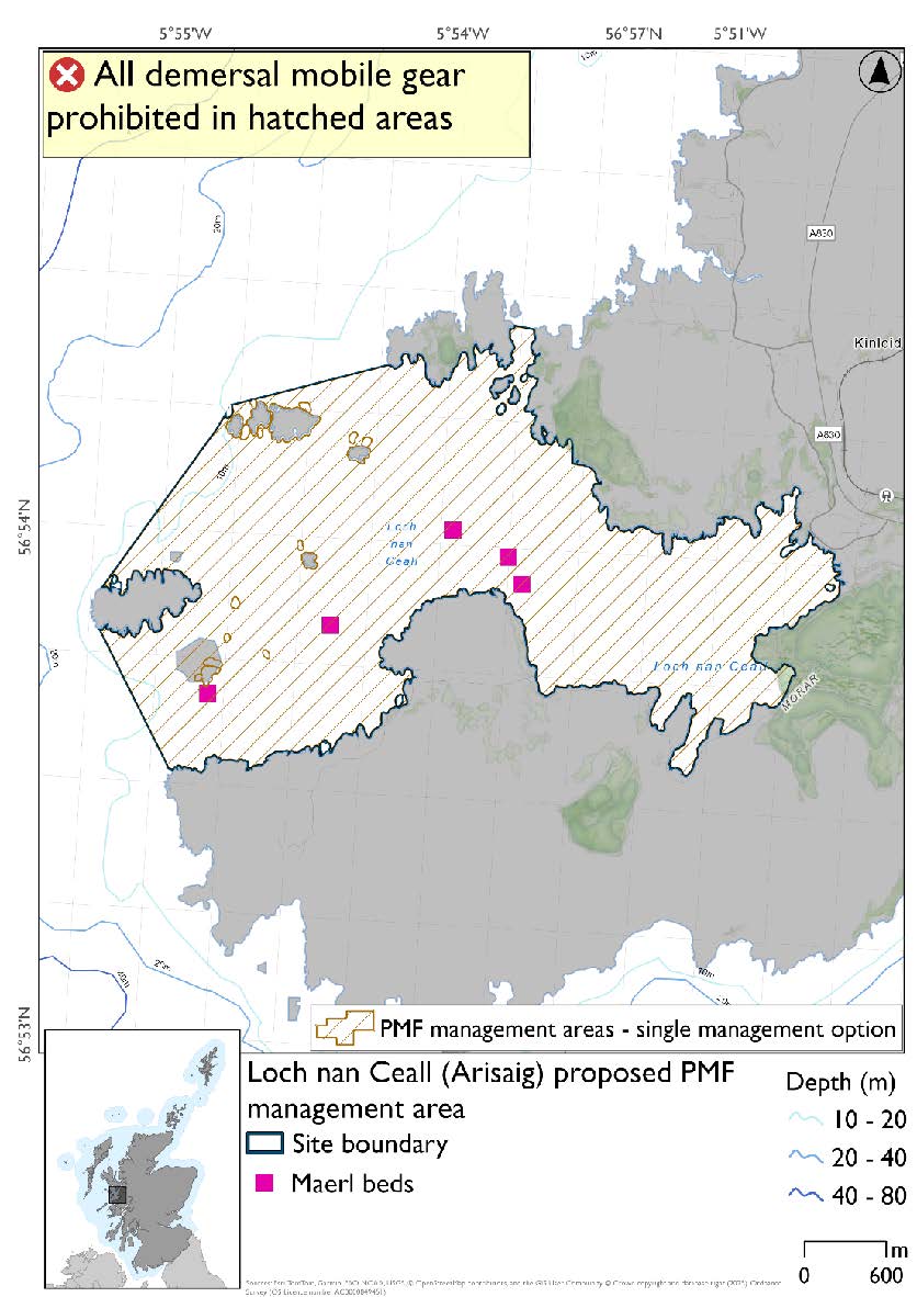
24.1.4. Area: Loch nan Ceall (Arisaig)
This proposed PMF management area overlaps with the Inner Hebrides and the Minches SAC.
This PMF management area overlaps with management measures being consulted on for Inner Hebrides and the Minches SAC for set nets (not including fyke nets) which are not shown in the map below.
No additional fishing data were provided within the proposed PMF management area.
Please check overlapping site map option(s) to see static gear measures.
Feature: Maerl beds
Figure 216. Map of measures proposed:
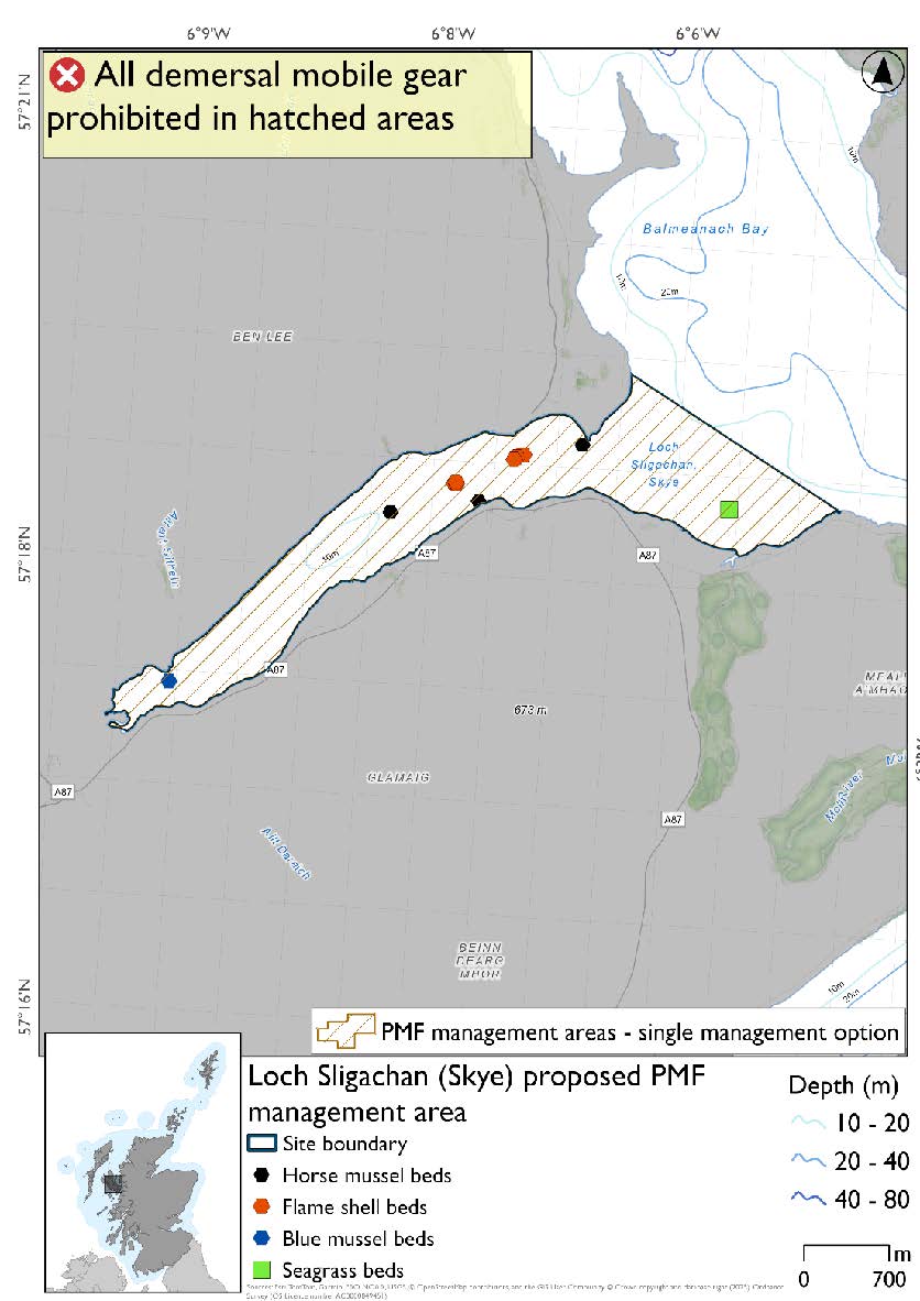
24.1.5. Area: Loch Sligachan (Skye)
This proposed PMF management area overlaps with the Inner Hebrides and the Minches SAC.
This PMF management area overlaps with management measures being consulted on for Inner Hebrides and the Minches SAC for set nets (not including fyke nets) which are not shown in the map below.
Please check overlapping site map option(s) to see static gear measures.
No additional fishing data were provided within the proposed PMF management area.
Feature: Horse mussel beds, flame shell beds
There are also intertidal seagrass and blue mussel beds present, but they were not considered as part of this process due to there being no overlaps with bottom-contacting fisheries and intertidal beds.
Figure 217. Map of measures proposed:
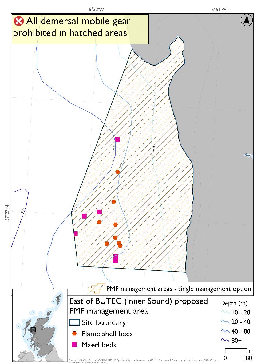
24.1.6. Area: East of BUTEC (Inner Sound)
This proposed PMF management area overlaps with the Inner Hebrides and the Minches SAC.
This PMF management area overlaps with management measures being consulted on for Inner Hebrides and the Minches SAC for set nets (not including fyke nets) which are not shown in the map below.
The 2018 area’s boundary was amended to better reflect the distribution of the flame shell bed and maerl bed records. No additional fishing data were provided within the proposed PMF management area.
Please check overlapping site map option(s) to see static gear measures.
Feature: Maerl beds, Flame shell beds
Figure 218. Map of measures proposed:
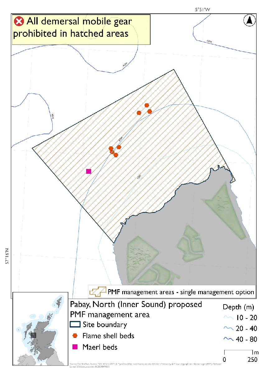
24.1.7. Area: Pabay, North (Inner Sound)
This proposed PMF management area overlaps with the Inner Hebrides and the Minches SAC.
This PMF management area overlaps with management measures being consulted on for Inner Hebrides and the Minches SAC for set nets (not including fyke nets) which are not shown in the map below.
No additional fishing data were provided within the proposed PMF management area.
Please check overlapping site map option(s) to see static gear measures.
Feature: Maerl beds, Flame shell beds
Figure 219. Map of measures proposed:
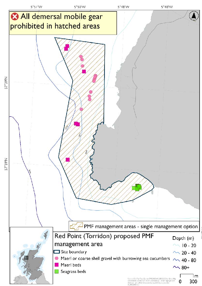
24.1.8. Area: Red Point (Torridon)
This proposed PMF management area overlaps with the Inner Hebrides and the Minches SAC.
This PMF management area overlaps with management measures being consulted on for Inner Hebrides and the Minches SAC for set nets (not including fyke nets) which are not shown in the map below.
The boundary of the 2018 area was extended in the north to include additional PMF records and straightened in the south. No additional fishing data were provided within the proposed PMF management area.
Please check overlapping site map option(s) to see static gear measures.
Feature: Maerl beds, maerl or coarse shell gravel with burrowing sea cucumbers, Seagrass beds
Figure 220. Map of measures proposed:
24.1.9. Area: Rubha Chuaig (Inner Sound)
This proposed PMF management area overlaps with the Inner Hebrides and the Minches SAC.
This PMF management area overlaps with management measures being consulted on for Inner Hebrides and the Minches SAC for set nets (not including fyke nets) which are not shown in the map below.
The boundary of the 2018 area was amended to better reflect the extent of the PMF records. Additional fishing data were provided and accommodated whilst taking into account depth requirements for maerl beds and sufficient buffers around known records.
Please check overlapping site map option(s) to see static gear measures.
Feature: Maerl beds, flame shell beds
There are also maerl or coarse shell gravel with burrowing sea cucumber records present, but they were not a focus for this area’s selection.
Figure 221. Map of measures proposed*:
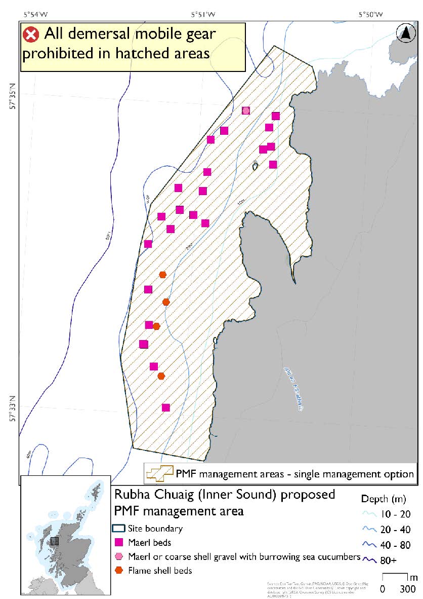
*A maerl and coarse shell gravel with burrowing sea cucumbers record is present on top of the most northern maerl bed record.
24.1.10. Area: Scalpay, North (Inner Sound)
This proposed PMF management area overlaps with the Inner Hebrides and the Minches SAC.
This PMF management area overlaps with management measures being consulted on for Inner Hebrides and the Minches SAC for set nets (not including fyke nets) which are not shown in the map below.
The boundary of the 2018 area was amended to take account of Red Rocks and Longay MPA where additional maerl bed and flame shell bed records are protected. Additional fishing data were provided but the distribution of records in relation to these data meant no other changes were necessary.
Please check overlapping site map option(s) to see static gear measures.
Feature: Maerl beds, flame shell beds
Figure 222. Map of measures proposed:

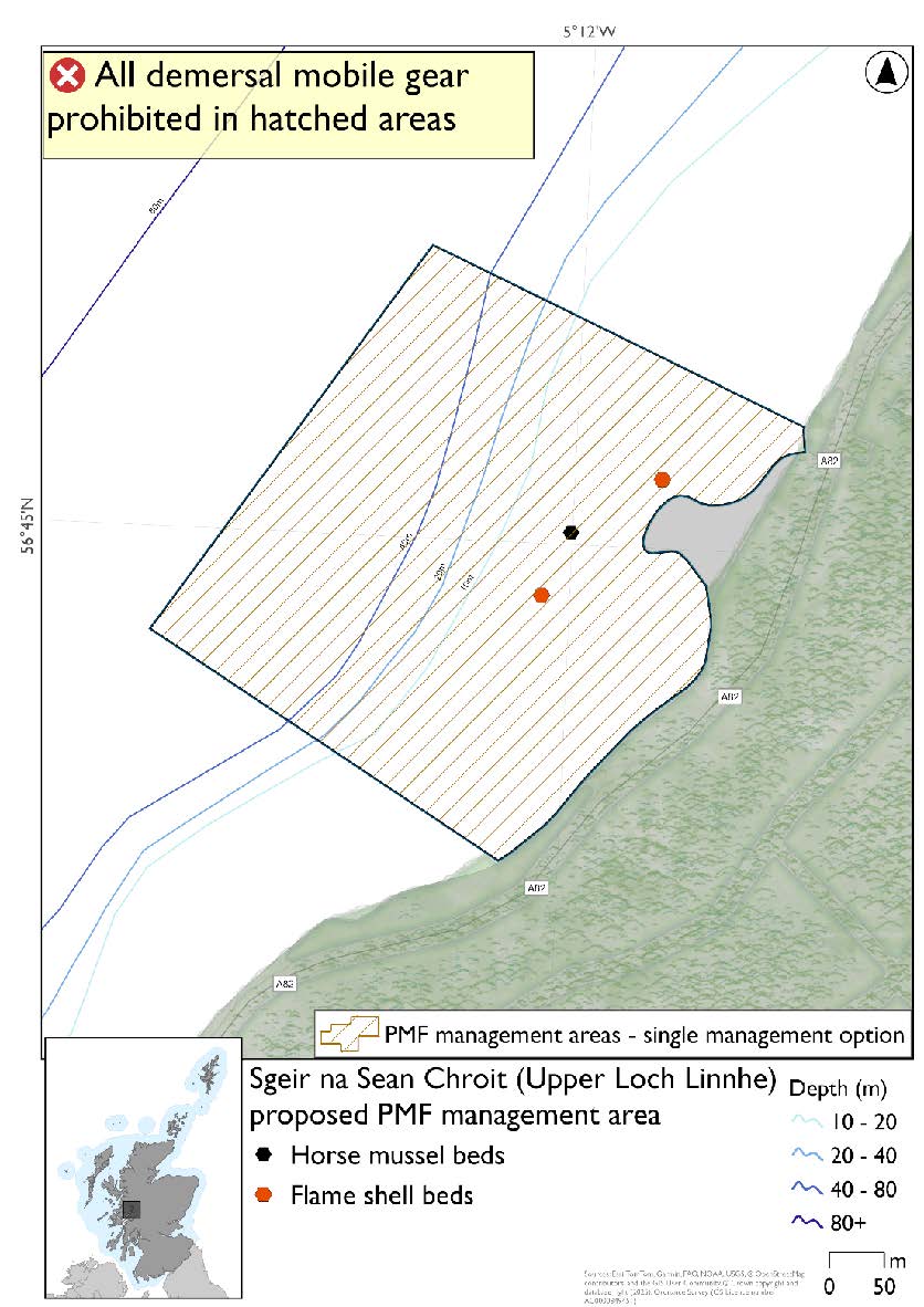
24.1.11. Area: Sgeir na Sean Chroit (Upper Loch Linnhe)
This option reflects the extent of the current survey data and is situated on a steeply sloping seabed that extends to depths that are suitable for horse mussel beds. No additional fishing data were provided within the proposed PMF management area.
Feature: Horse mussel beds, flame shell beds
Figure 223. Map of measures proposed:
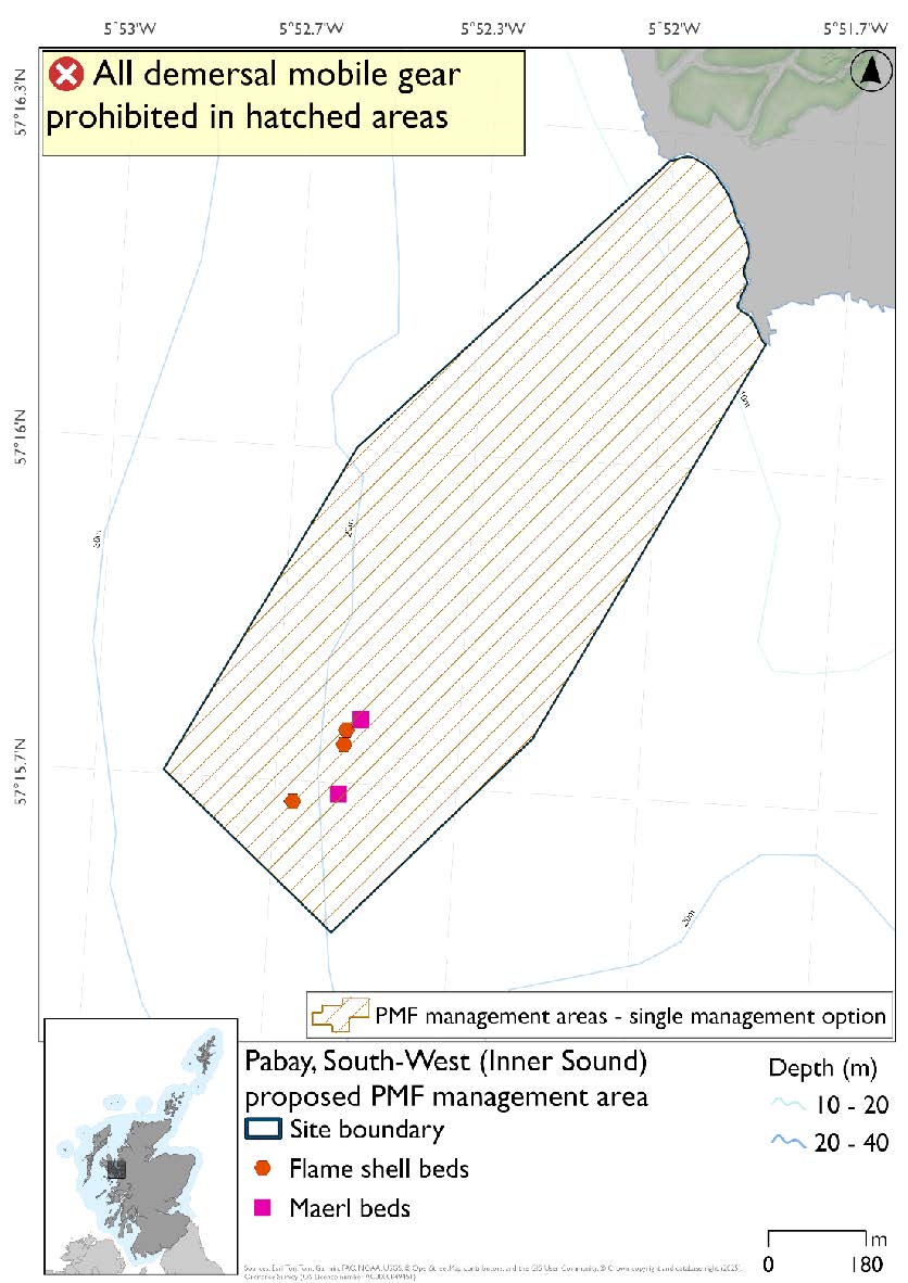
24.1.12. Area: Pabay, South-West (Inner Sound)
This proposed PMF management area overlaps with the Inner Hebrides and the Minches SAC.
This PMF management area overlaps with management measures being consulted on for Inner Hebrides and the Minches SAC for set nets (not including fyke nets) which are not shown in the map below.
No additional fishing data were provided within the proposed PMF management area.
Please check overlapping site map option(s) to see static gear measures.
Feature: Flame shell, maerl beds
Figure 224. Map of measures proposed:
24.2. Two Proposed management options
PMF management areas will be closed to demersal trawls and seines, beam trawls, mechanical dredges, and hydraulic dredges. This is because the features present in these areas are sensitive to these gear types.
Two options have been developed for the following 18 PMF management areas. Option 1 reflects a smaller footprint that reflects one, or a combination of evidence (fishing activity or PMF related), boundary setting principles and compliance considerations. Option 2 covers a larger footprint that offers improved protection.
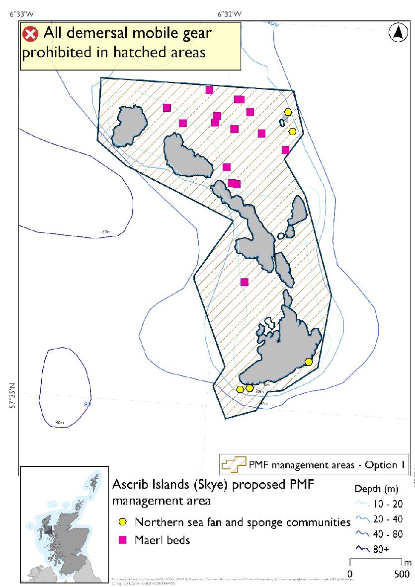
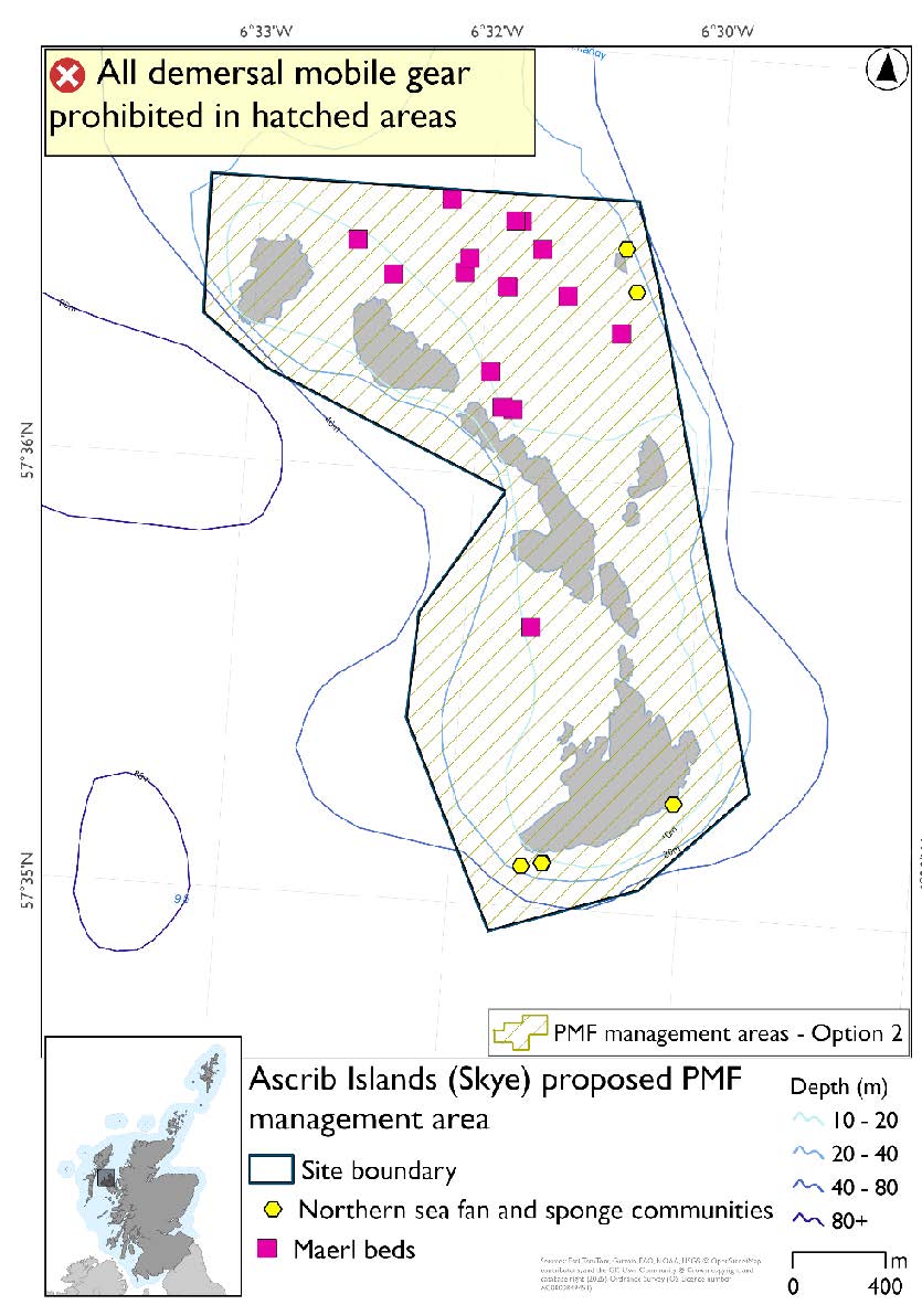
24.2.1. Area: Ascrib Islands (Skye)
This proposed PMF management area overlaps with the Ascrib, Isay and Dunvegan and Inner Hebrides and the Minches SACs.
This PMF management area overlaps with management measures being consulted on for Ascrib, Isay and Dunvegan and Inner Hebrides and the Minches SACs for set nets (not including fyke nets) and Ascrib, Isay and Dunvegan SAC for pelagic seine (including ring-nets) which are not shown in the maps below.
Please check overlapping site map option(s) to see static and pelagic gear measures.
Feature: Maerl beds, northern sea fan and sponge communities
Option 1: Closely following the majority of the PMF records. Additional fishing activity data were accommodated where possible whilst still providing adequate buffers around the PMFs.
Figure 225. Map of measures proposed under option 1:
Option 2: This boundary covers a larger footprint that is extended in the southeast and west to include additional habitat of suitable depth.
Figure 226. Map of measures proposed under option 2:
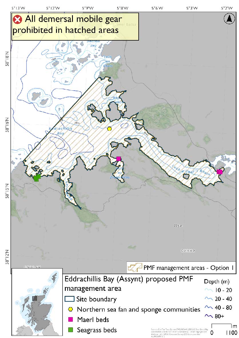
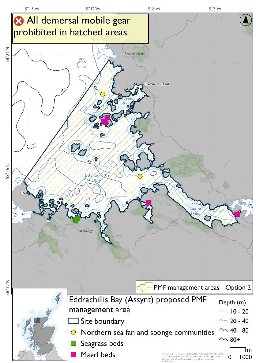
24.2.2. Area: Eddrachillis Bay (Assynt)
Feature: Maerl beds and seagrass beds
There are also northern sea fan and sponge communities records present, but they were not a focus for this area’s selection.
The options were reduced on the eastern side, removing head of the loch, to better reflect known records at the time. There is a horse mussel bed record at the head of the loch but this is from 1988. No additional fishing data were provided within the proposed PMF management areas.
The additional maerl bed and northern sea fan and sponge communities records in Option 2 at the mouth of the loch are from survey data from 2023 and 2025 that was available after areas were finalised for consultation. There are maerl bed records from the 2025 survey outside both management options at the head of the loch that were not available when options were finalised for consultation.
Option 1: This boundary covers a smaller footprint which excludes some maerl beds and northern sea fan and sponge communities in the outer reaches of the loch
Figure 227. Map of measures proposed under option 1:
Option 2: This boundary covers a larger footprint which includes additional maerl beds, northern sea fan and sponge communities and further suitable habitat.
Figure 228. Map of measures proposed under option 2:
24.2.3. Area: Eigg, South-East
This proposed PMF management area overlaps with the Sea of the Hebrides NCMPA and Inner Hebrides and the Minches SAC.
This PMF management area overlaps with management measures being consulted on for Inner Hebrides and the Minches SAC and Sea of the Hebrides NCMPA for set nets (not including fyke nets) which are not shown in the maps below.
Please check overlapping site map option(s) to see static gear measures. Both maps show the same thing for overlapping portion.
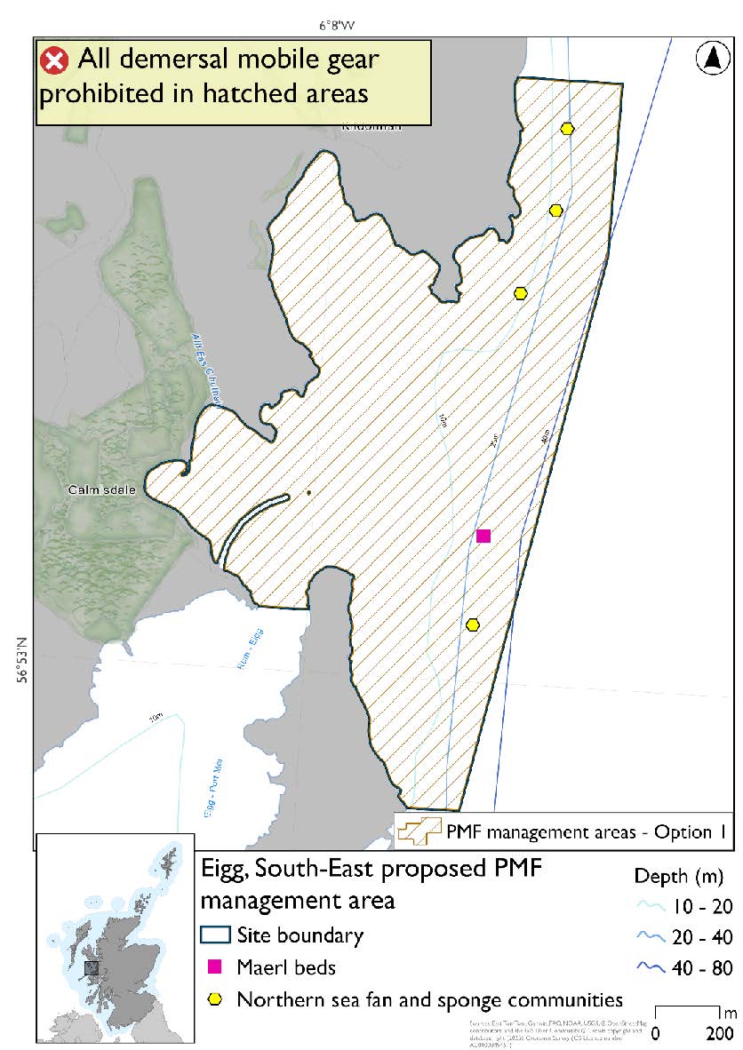
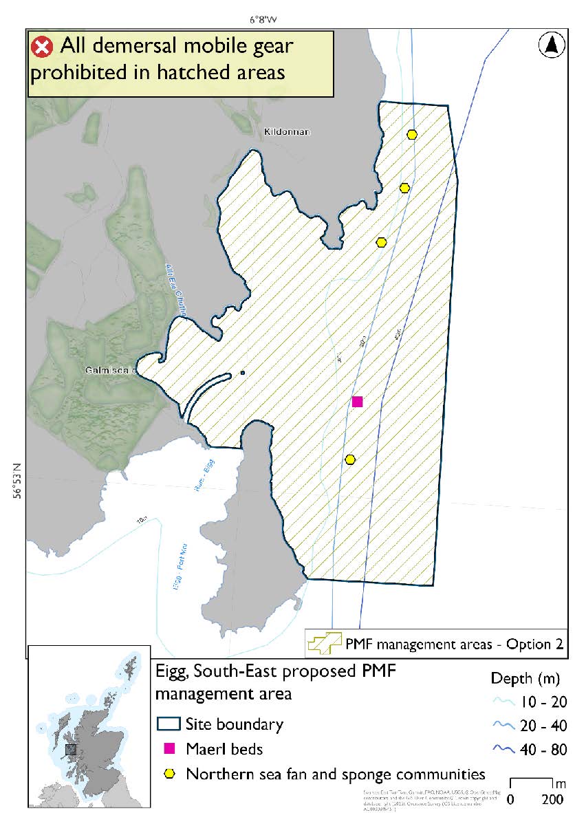
Feature: Northern sea fan and sponge communities and maerl beds
Option 1: This boundary covers a smaller footprint. Additional fishing data were provided and the area reduced whilst including suitable depths for maerl beds, the existing PMF records and buffers around these.
Figure 229. Map of measures proposed under option 1:
Option 2: This boundary covers a larger footprint that offers improved protection.
Figure 230. Map of measures proposed under option 2:
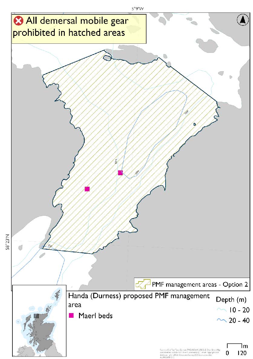
24.2.4. Area: Handa (Durness)
This proposed PMF management area overlaps with the Handa SPA.
This PMF management area overlaps with management measures being consulted on for Handa SPA for set nets (including fyke nets) and longlines (until technical measures come into force) which are not shown in the maps below.
No additional fishing data were provided within the proposed PMF management areas.
Please check overlapping site map option(s) to see static gear and longline measures.
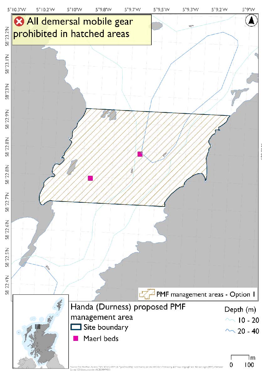
Feature: Maerl beds
Option 1: This boundary covers a smaller footprint that more closely encompasses the PMF records.
Figure 231. Map of measures proposed under option 1:
Option 2: This boundary covers a larger footprint offering protection for additional potential habitat for maerl beds based on suitable depths.
Figure 232. Map of measures proposed under option 2:
24.2.5. Area: Inverie, Loch Nevis (Knoydart)
No additional fishing data were provided within the proposed PMF management areas.
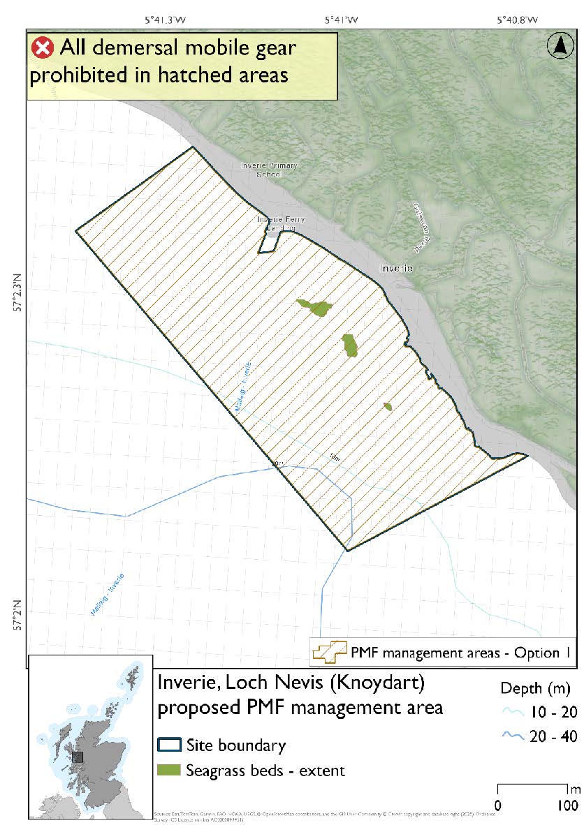
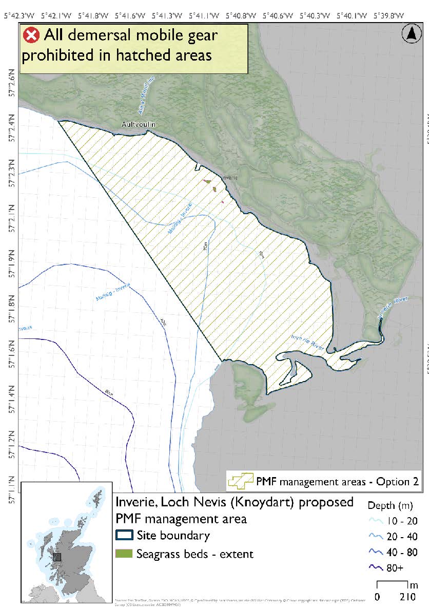
Feature: Seagrass beds
Option 1: This boundary covers a smaller footprint to encompass the records of the PMF more closely.
Figure 233. Map of measures proposed under option 1:
Option 2: This boundary covers a larger footprint that offers improved protection.
Figure 234. Map of measures proposed under option 2:
24.2.6. Area: Little Minch
This proposed PMF management area overlaps with the Sea of the Hebrides NCMPA and Inner Hebrides and the Minches SAC.
This PMF management area overlaps with management measures being consulted on for Inner Hebrides and the Minches SAC and Sea of the Hebrides NCMPA for set nets (not including fyke nets) which are not shown in the maps below.
Please check one of the overlapping site map option(s) to see static gear measures. Both sets of maps show the same thing for overlapping portion.
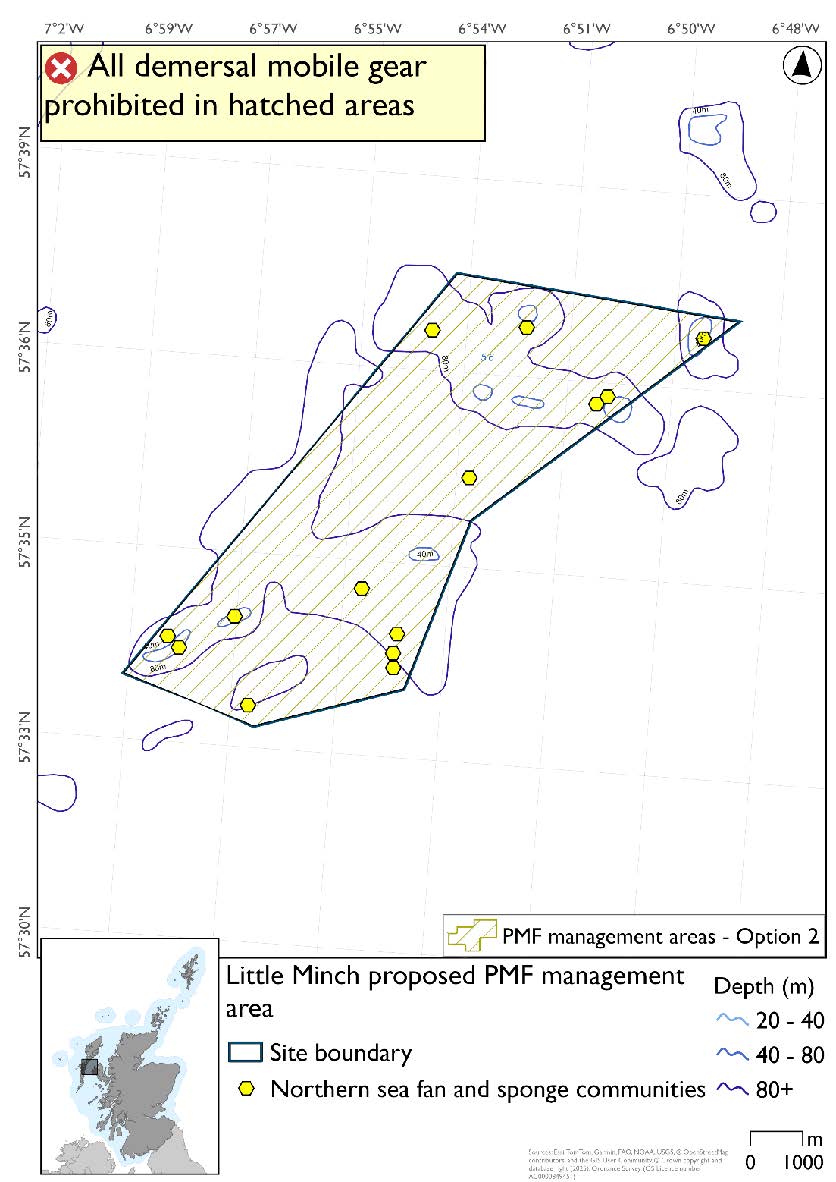
Option 2 has northern sea fan and sponge communities that were not included in Option 1. NatureScot proposed that the focus of measures be around the clusters of existing 2011 records noting that it may be possible to split the area for Option 1 based on available survey and bathymetric data. The area between the northeast and southwest parts under Option 1 primarily supports northern sea fan species records only (low density presence).
Feature: Northern sea fan and sponge communities
Option 1: This boundary covers a smaller footprint over two discrete areas that encompass known PMF records. It also accommodates additional fishing data that were provided which overlaps the low density species only records of northern sea fan.
Figure 235. Map of measures proposed under option 1:

Option 2: This boundary covers a larger footprint which includes additional lower relief habitat that is suitable for the northern sea fan species.
Figure 236. Map of measures proposed under option 2:
24.2.7. Area: Loch Bay (Skye)
This proposed PMF management area overlaps with the Ascrib, Isay and Dunvegan and Inner Hebrides and the Minches SACs.
This PMF management area overlaps with management measures being consulted on for Ascrib, Isay and Dunvegan and Inner Hebrides and the Minches SACs for set nets (not including fyke nets) and Ascrib, Isay and Dunvegan SAC for pelagic seine (including ring-nets) which are not shown in the maps below.
Please check overlapping site map option(s) to see static and pelagic gear measures.
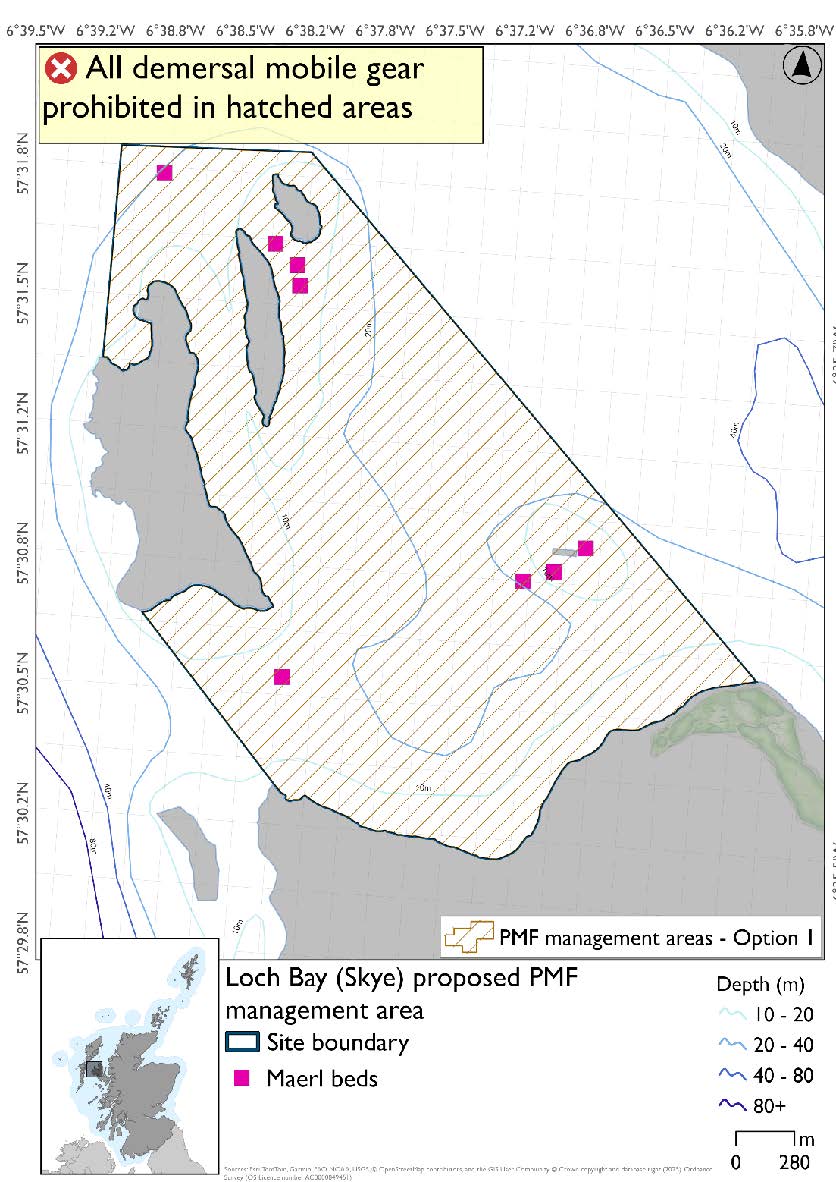
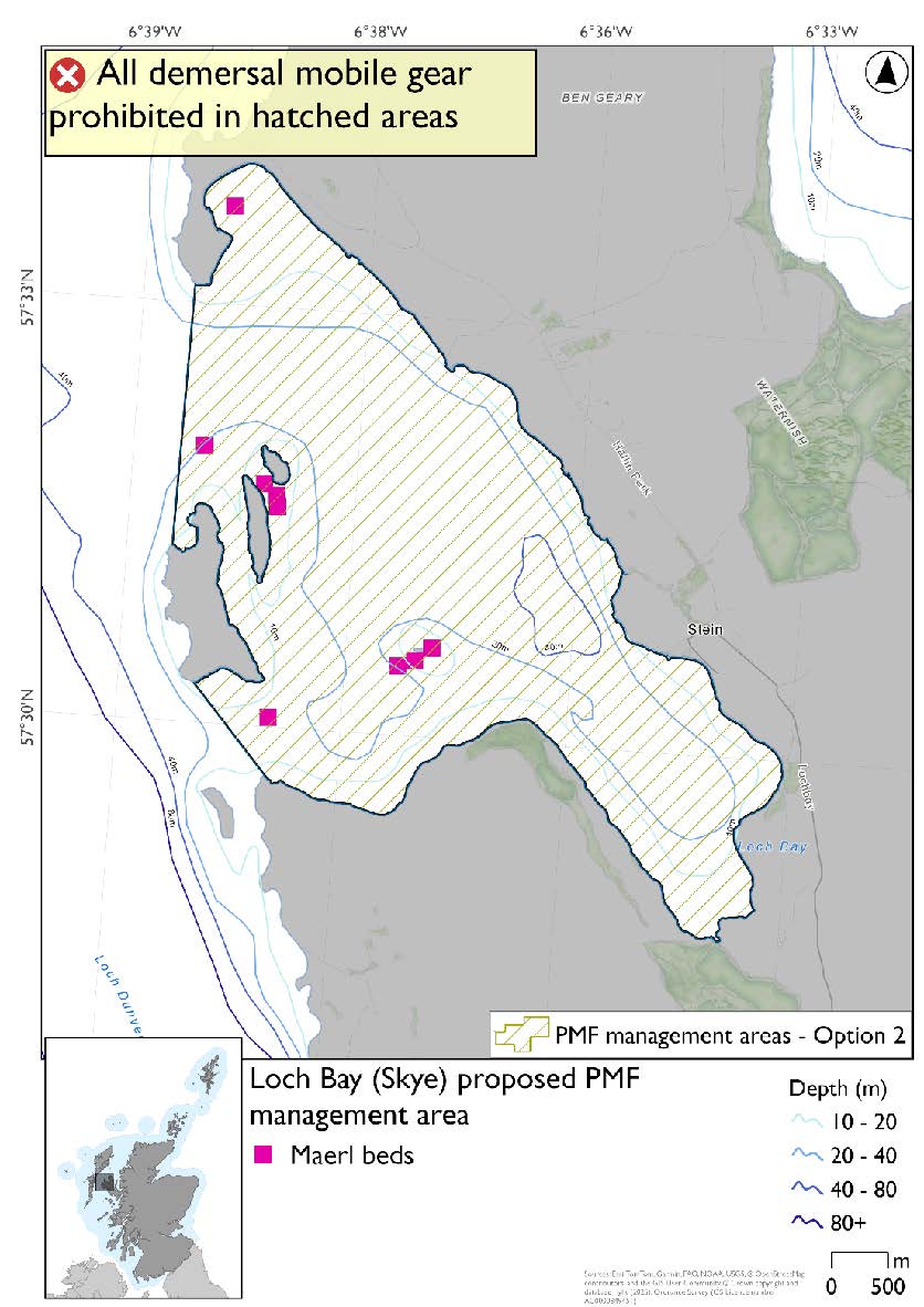
Option 2 (the 2018 area) has an additional maerl bed record not included in Option 1 as further survey work in 2024 and 2025 confirmed a new maerl bed in Ardmore Bay at the northern end of the 2018 area which wasn’t available when the areas were finalised for consultation.
Feature: Maerl beds
Option 1: This boundary covers a smaller footprint encompassing a few clusters of maerl beds around the small islands in the southern, outer areas of the loch. Additional fishing data were provided and accommodated prior to knowing about the 2024/25 maerl bed data.
Figure 237. Map of measures proposed under option 1:
Option 2: This boundary covers a larger footprint and extends to include more maerl bed records in the north as well as including additional suitable habitat within the head of the loch.
Figure 238. Map of measures proposed under option 2:
24.2.8. Area: Loch Bracadale (Skye)
This proposed PMF management area overlaps with the Inner Hebrides and the Minches SAC.
This PMF management area overlaps with management measures being consulted on for Inner Hebrides and the Minches SAC for set nets (not including fyke nets) which are not shown in the maps below.
Please check overlapping site map option(s) to see static gear measures.
Feature: Maerl beds and maerl or coarse shell gravel with burrowing sea cucumbers
There are also intertidal seagrass and blue mussel beds present, but they were not considered as part of this process due to there being no overlaps with bottom-contacting fisheries and intertidal beds.
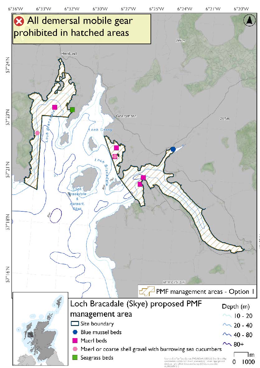
Option 1: This boundary covers a smaller footprint, over two discrete areas of the loch, to reflect the known records. Additional fishing data were received and accommodated whilst protecting known records at the time of finalising the options for consultation and including buffers.
Figure 239. Map of measures proposed under option 1:
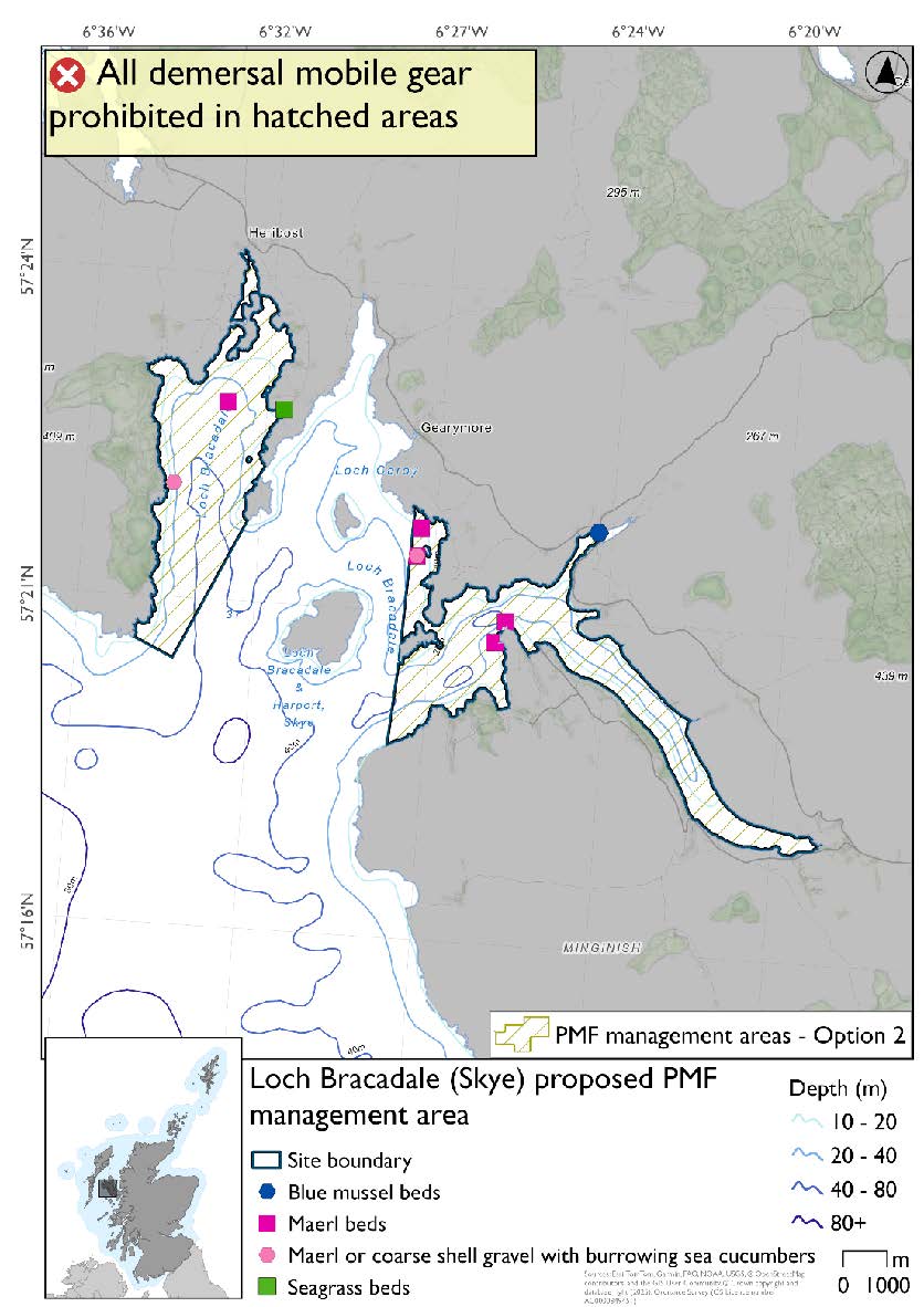
Option 2: This boundary covers a larger footprint that includes additional suitable habitat for the PMFs.
Figure 240. Map of measures proposed under option 2:
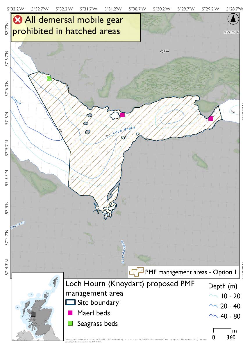
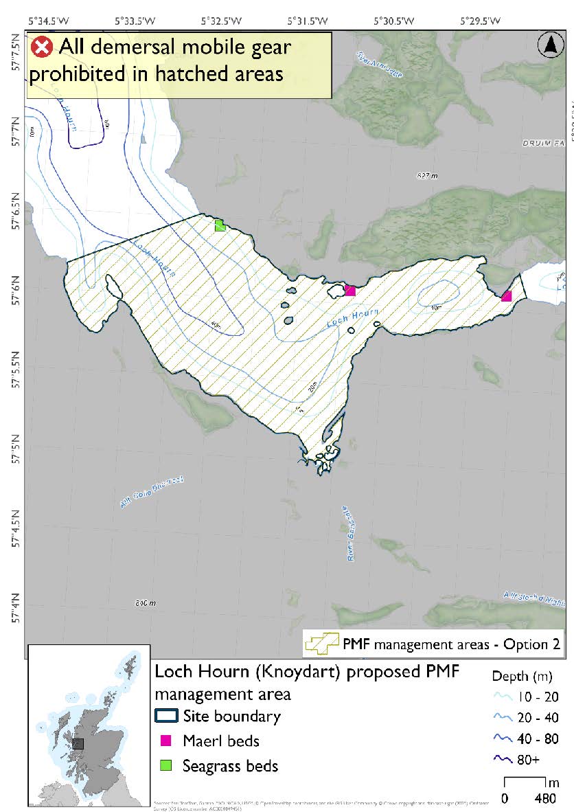
24.2.9. Area: Loch Hourn (Knoydart)
Feature: Maerl beds and seagrass beds
Option 1: This boundary covers a smaller footprint that encompasses known records of the PMFs. Additional fishing data were received and accommodated, whilst protecting known records at the time of finalising the options for consultation and including buffers.
Figure 241. Map of measures proposed under option 1:
Option 2: This boundary covers a larger footprint, including additional suitable habitat for the PMFs.
Figure 242. Map of measures proposed under option 2:
24.2.10. Area: Loch nan Uamh (Arisaig)
This proposed PMF management area overlaps with the Inner Hebrides and the Minches SAC.
This PMF management area overlaps with management measures being consulted on for Inner Hebrides and the Minches SAC for set nets (not including fyke nets) which are not shown in the maps below.
Please check overlapping site map option(s) to see static gear measures.
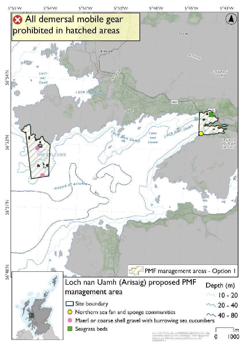
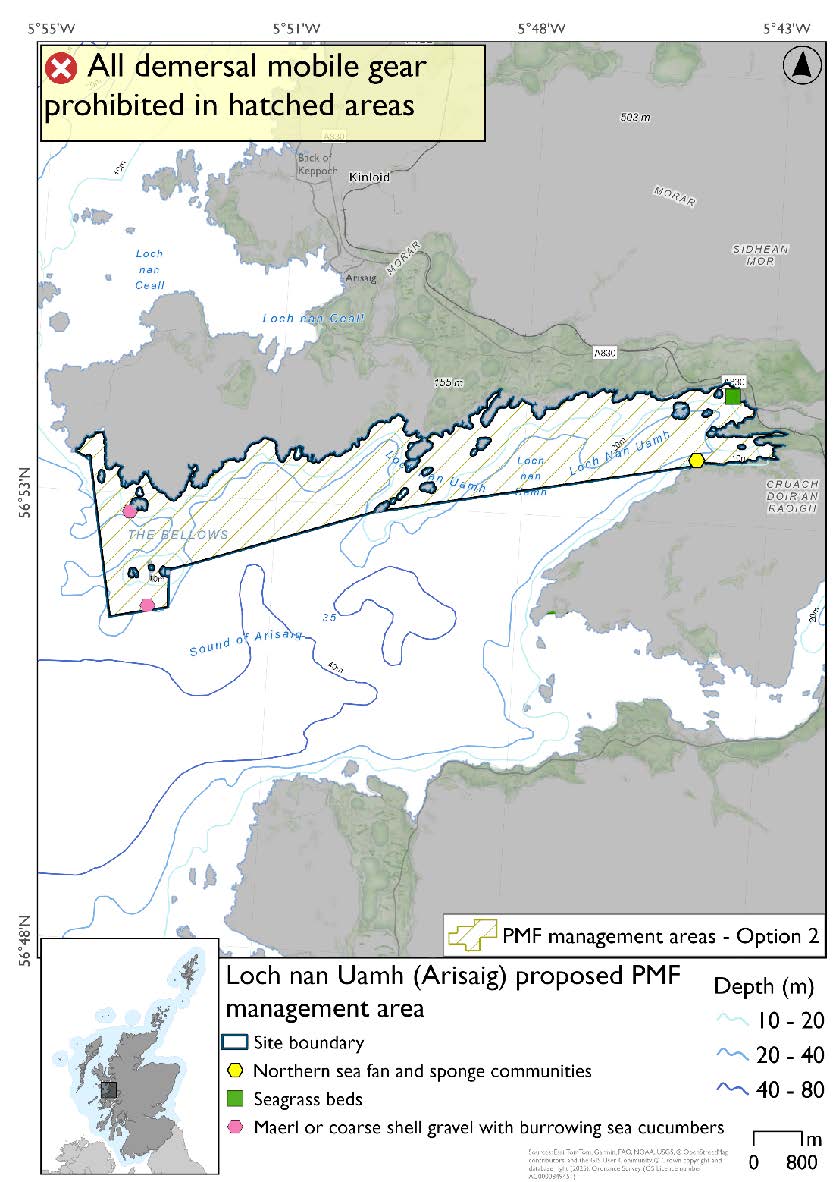
Feature: Maerl beds or coarse shell gravel with burrowing sea cucumbers, northern sea fan and sponge communities, seagrass beds
There are also intertidal blue mussel records present, but they were not considered part of this process due to there being no overlaps with bottom-contacting fisheries and intertidal mussel beds.
Option 1: This boundary covers a smaller footprint with two discrete locations at head and mouth of loch that encompass known PMF records. Additional fishing data were received and accommodated whilst protecting known records at the time of finalising the options for consultation and including buffers.
Figure 243. Map of measures proposed under option 1:
Option 2: This boundary covers a larger footprint along the northern edge of the loch including additional habitat suitable for PMFs.
Figure 244. Map of measures proposed under option 2:
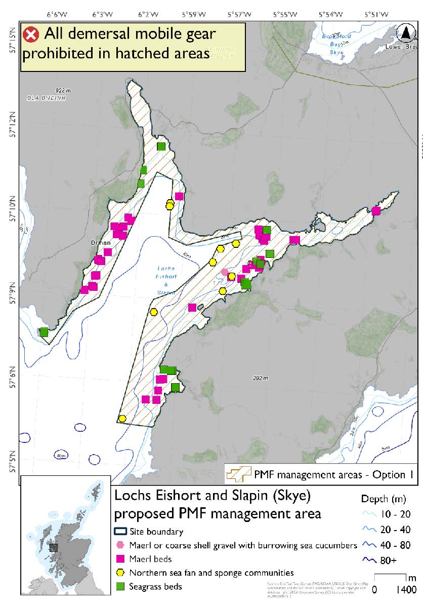
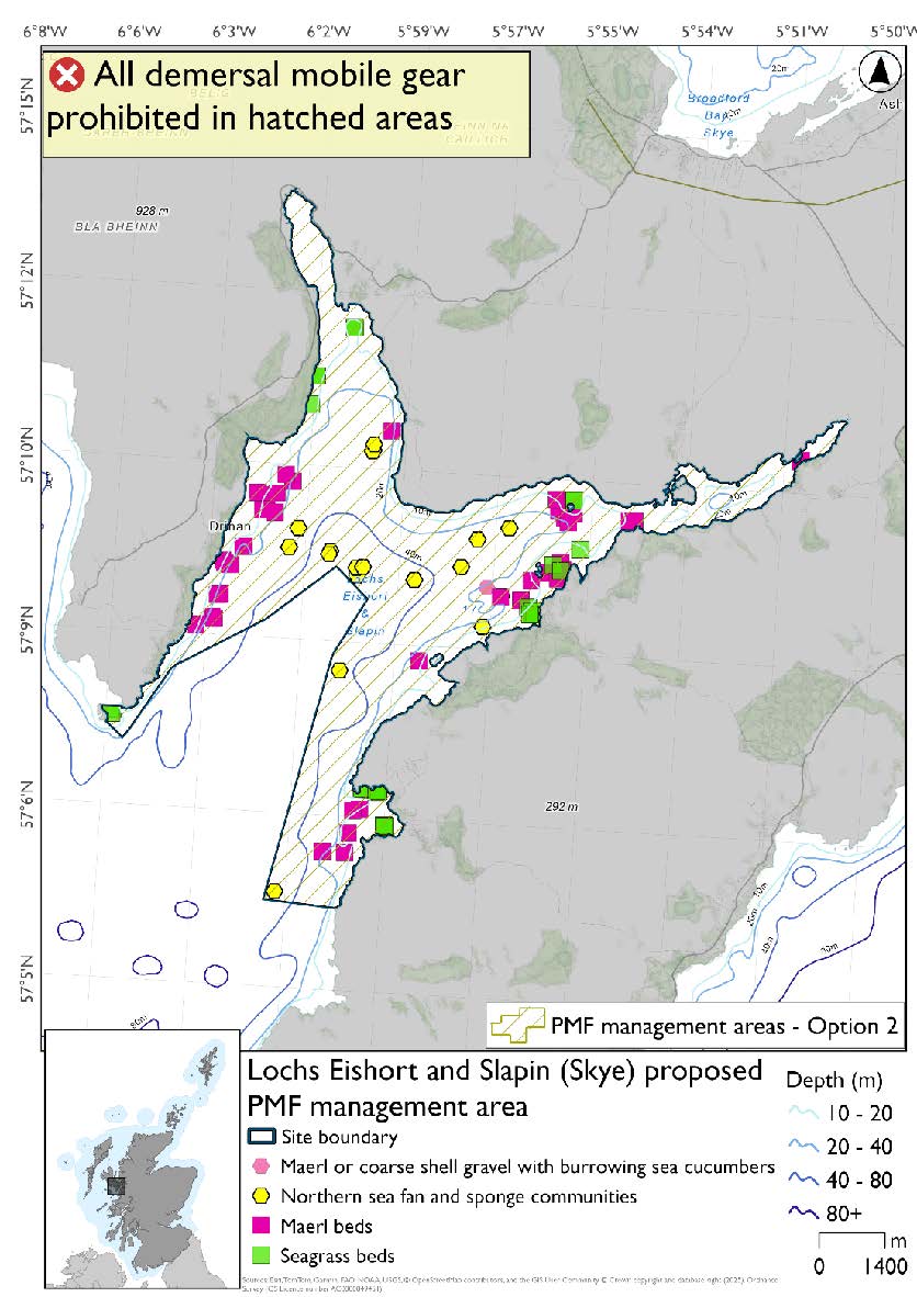
24.2.11. Area: Lochs Eishort and Slapin (Skye)
This proposed PMF management area overlaps with the Inner Hebrides and the Minches SAC.
This PMF management area overlaps with management measures being consulted on for Inner Hebrides and the Minches SAC for set nets (not including fyke nets) which are not shown in the maps below.
Please check overlapping site map option(s) to see static gear measures.
Option 2 has northern sea fan and sponge communities that were not included in Option 1. The excluded area overlaps with additional fishing data that were provided. The excluded northern sea fan and sponge communities records are considered to be of lower diversity.
Feature: Maerl beds, seagrass beds, northern sea fan and sponge communities, maerl or coarse shell gravel with burrowing sea cucumbers
Option 1: This boundary covers a smaller footprint around the margins of the loch, excluding mostly deeper mud habitats not suitable for the PMFs being considered in this process, and accommodating, where possible, additional fishing data that were provided.
Figure 245. Map of measures proposed under option 1:
Option 2: This boundary covers a larger footprint that includes additional records of northern sea fan and sponge communities (lower diversity examples) on silted rock outcrops in mud.
Figure 246. Map of measures proposed under option 2:
24.2.12. Area: Loch Ainort and Caolas Scalpay (Skye)
This proposed PMF management area overlaps with the Inner Hebrides and the Minches SAC.
This PMF management area overlaps with management measures being consulted on for Inner Hebrides and the Minches SAC for set nets (not including fyke nets) which are not shown in the maps below.
No additional fishing data were provided within the proposed PMF management areas.
Please check overlapping site map option(s) to see static gear measures.
Feature: Flame shell beds, maerl beds, horse mussel beds and seagrass beds
Option 1*: This boundary covers a smaller footprint that encompasses the PMFs with a simple boundary lines across to Scalpay.
Figure 247. Map of measures proposed under option 1:
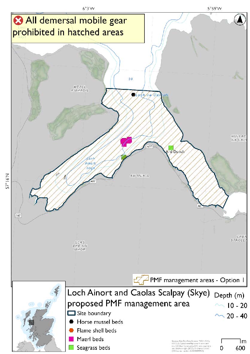
*Flame shell bed records are present amongst the large cluster of maerl bed records.
Option 2*: This boundary covers a larger footprint and includes additional habitat that may be suitable for the PMFs.
Figure 248. Map of measures proposed under option 2:
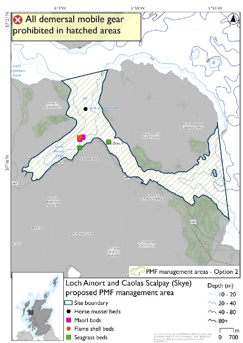
*Flame shell bed records are present amongst the large cluster of maerl bed records.
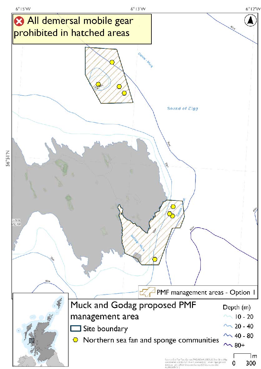
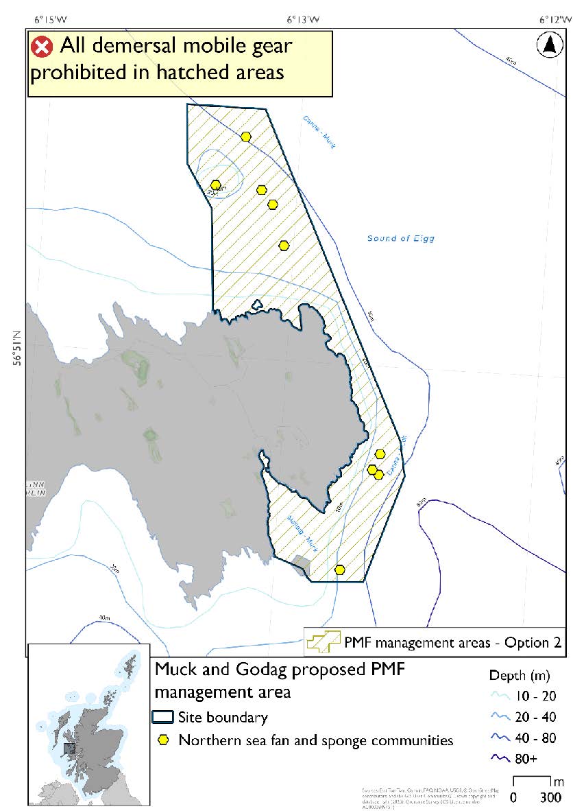
24.2.13. Area: Muck and Godag
This proposed PMF management area overlaps with the Sea of the Hebrides NCMPA and Inner Hebrides and Minches SAC.
This PMF management area overlaps with management measures being consulted on for Inner Hebrides and the Minches SAC and Sea of the Hebrides NCMPA for set nets (not including fyke nets) which are not shown in the maps below.
Please check one of the overlapping site map option(s) to see static gear measures. Both sets of maps show the same thing for overlapping portion.
No additional fishing data were provided within the proposed PMF management area.
Option 2 includes an additional northern sea fan and sponge communities record in the northern section, not included in Option 1. This was from a 2025 survey where data were only available after the area was finalised for consultation.
Feature: Northern sea fan and sponge communities
Option 1: This boundary covers a smaller footprint within two discrete areas around known PMF records.
Figure 249. Map of measures proposed under option 1:
Option 2: This boundary covers a larger single area that includes additional potential suitable habitat for the PMF.
Figure 250. Map of measures proposed under option 2:
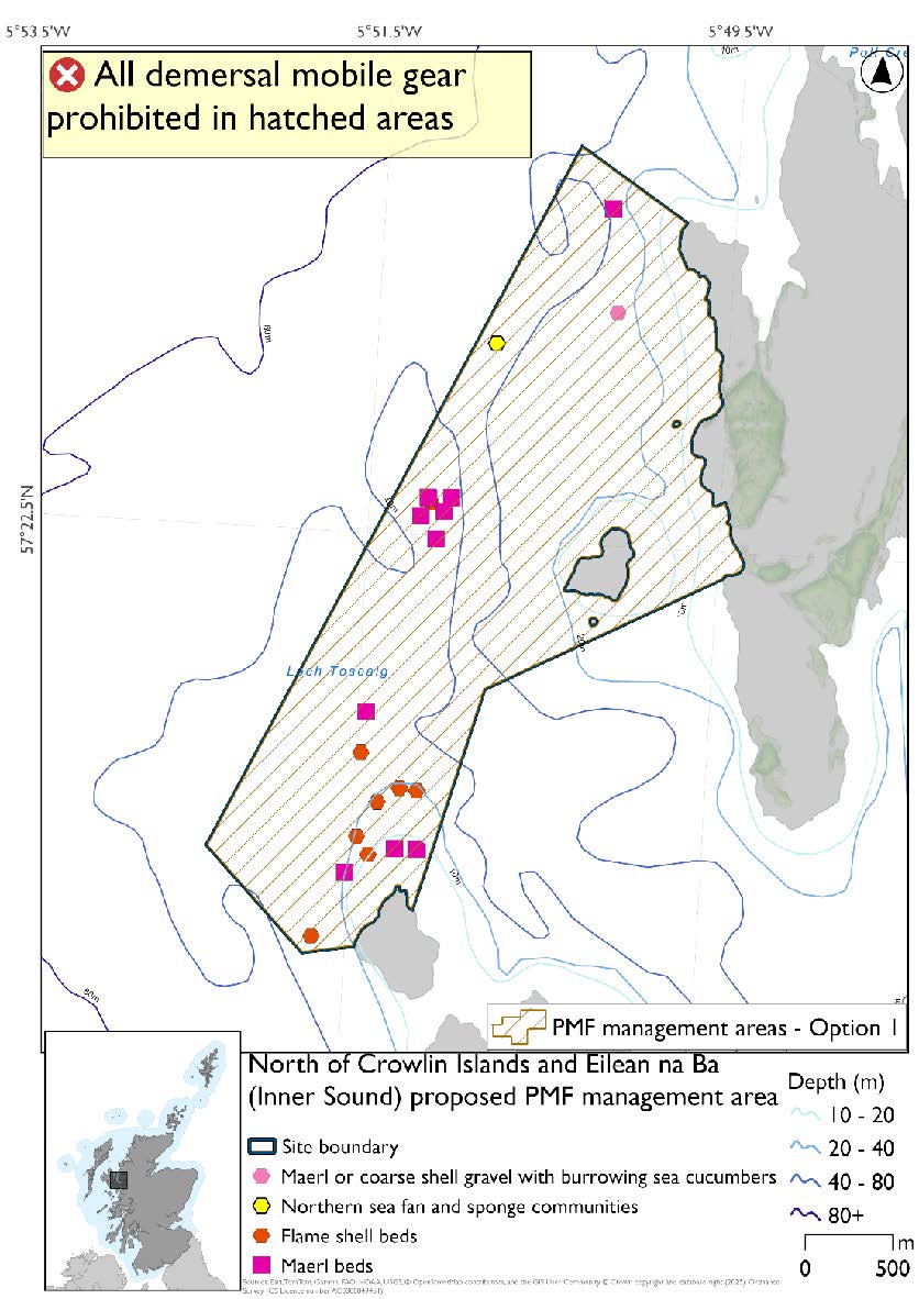
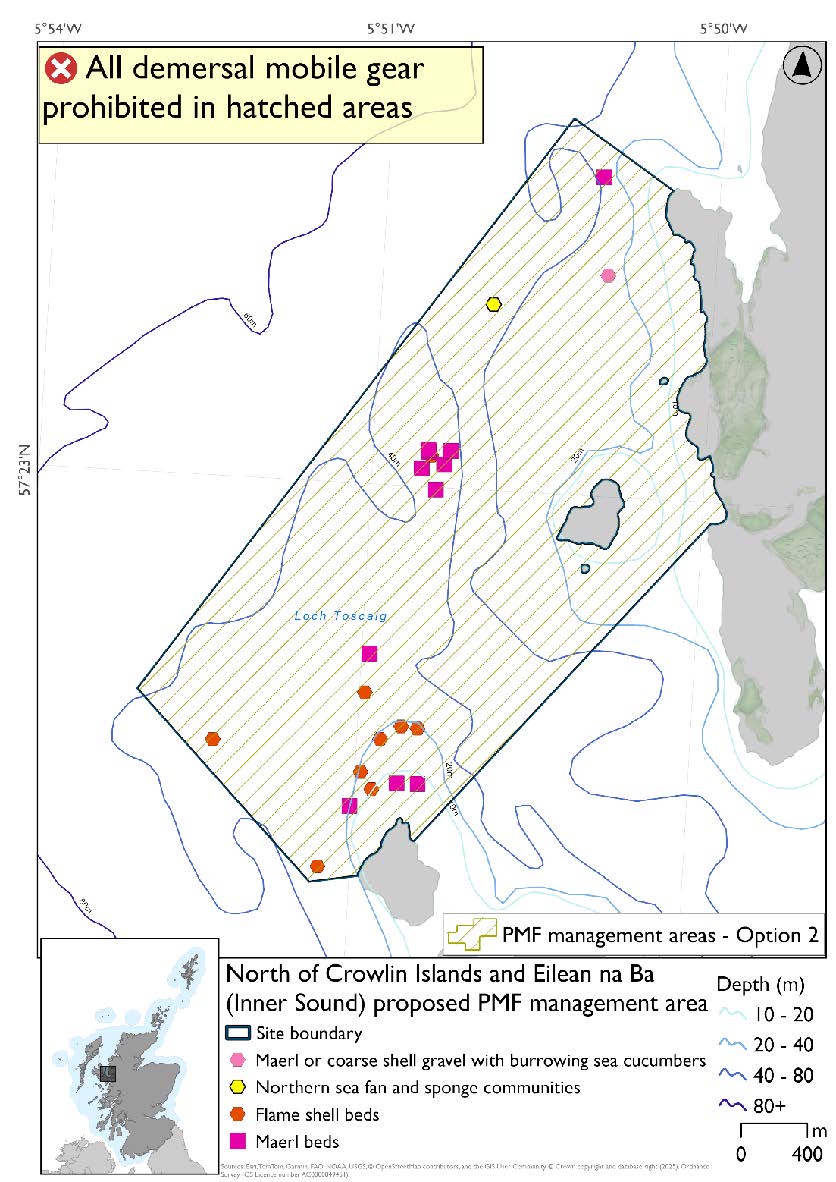
24.2.14. Area: North of Crowlin Islands and Eilean na Ba (Inner Sound)
This proposed PMF management area overlaps with the Inner Hebrides and the Minches SAC.
This PMF management area overlaps with management measures being consulted on for Inner Hebrides and the Minches SAC for set nets (not including fyke nets) which are not shown in the maps below.
Please check overlapping site map option(s) to see static gear measures.
No additional fishing data were provided within the proposed PMF management area.
Option 2 includes an additional flame shell bed record in the southwest section, not included in Option 1, as this was from a 2025 survey and data were not available until after the area was finalised for consultation.
Feature: Maerl beds and flame shell beds
There are also maerl or coarse shell gravel with burrowing sea cucumber and northern sea fan and sponge communities records present, but they were not the focus for this area’s selection.
Option 1: This boundary covers a smaller footprint that includes the clusters of PMF records.
Figure 251. Map of measures proposed under option 1:
Option 2: This boundary covers a larger footprint, and includes an additional record of flame shell beds, and habitat that may be suitable for the PMFs.
Figure 252. Map of measures proposed under option 2:
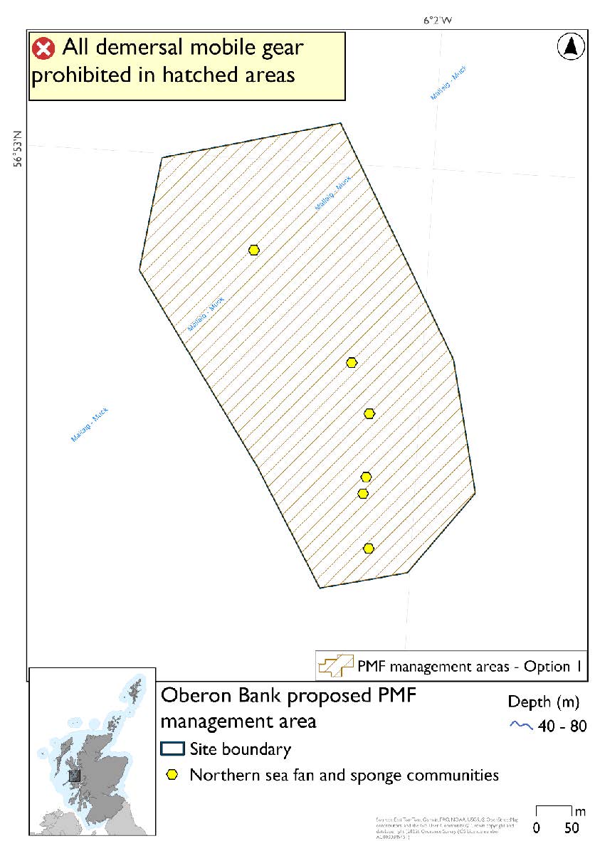
24.2.15. Area: Oberon Bank
This proposed PMF management area overlaps with the Sea of the Hebrides NCMPA and Inner Hebrides and the Minches SAC.
This PMF management area overlaps with management measures being consulted on for Inner Hebrides and the Minches SAC and Sea of the Hebrides NCMPA for set nets (not including fyke nets) which are not shown in the maps below.
Please check one of the overlapping site map option(s) to see static gear measures. Both sets of maps show the same thing for overlapping portion.
No additional fishing data were provided within the proposed PMF management area.
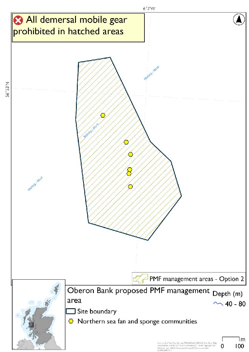
Feature: Northern sea fan and sponge communities
Option 1: This boundary covers a smaller footprint that includes the clusters of PMF records. The 2018 area was reduced due to additional 2019 survey data not finding the habitat in the southeast section of the proposed management area.
Figure 253. Map of measures proposed under option 1:
Option 2: This boundary covers a larger footprint that offers improved protection.
Figure 254. Map of measures proposed under option 2:
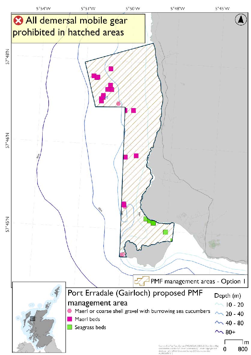
24.2.16. Area: Port Erradale (Gairloch)
This proposed PMF management area overlaps with the Inner Hebrides and the Minches SAC.
This PMF management area overlaps with management measures being consulted on for Inner Hebrides and the Minches SAC for set nets (not including fyke nets) which are not shown in the maps below.
Please check overlapping site map option(s) to see static gear measures.
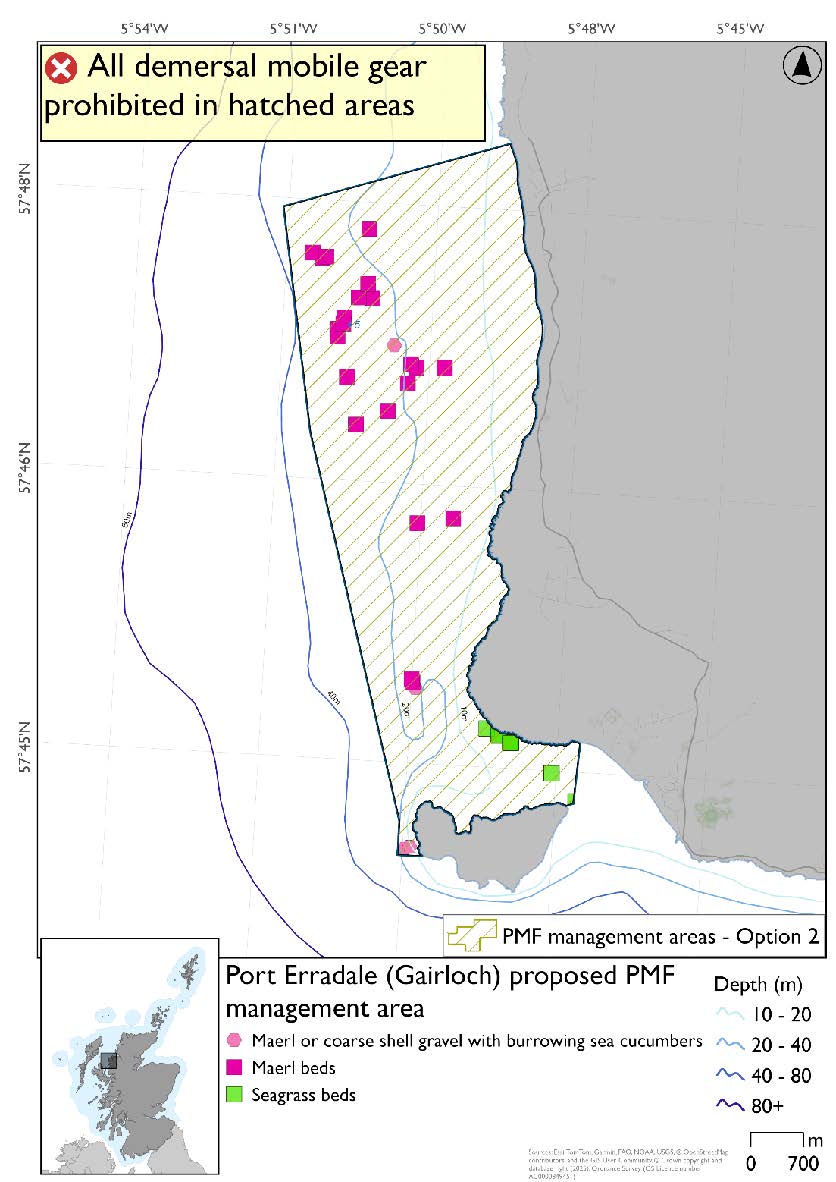
Option 2 includes additional maerl bed records in northeastern section, not included in Option 1, as these were from a 2023 survey where data were only available after the area was finalised for consultation.
Feature: Maerl beds and maerl or coarse shell gravel with burrowing sea cucumbers and seagrass beds
Option 1: This boundary covers a smaller footprint encompassing the records known at the time of finalising the area for consultation. Additional fishing data were provided and accommodated whilst still protecting the PMF records with buffers.
Figure 255. Map of measures proposed under option 1:
Option 2: This boundary covers a larger footprint incorporating further new maerl bed records from 2023 and additional habitat at depths suitable for this PMF.
Figure 256. Map of measures proposed under option 2:
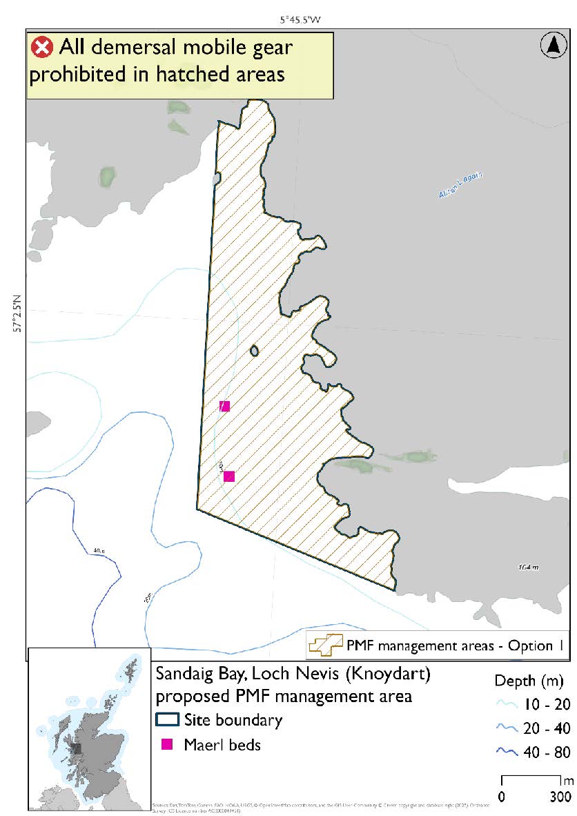
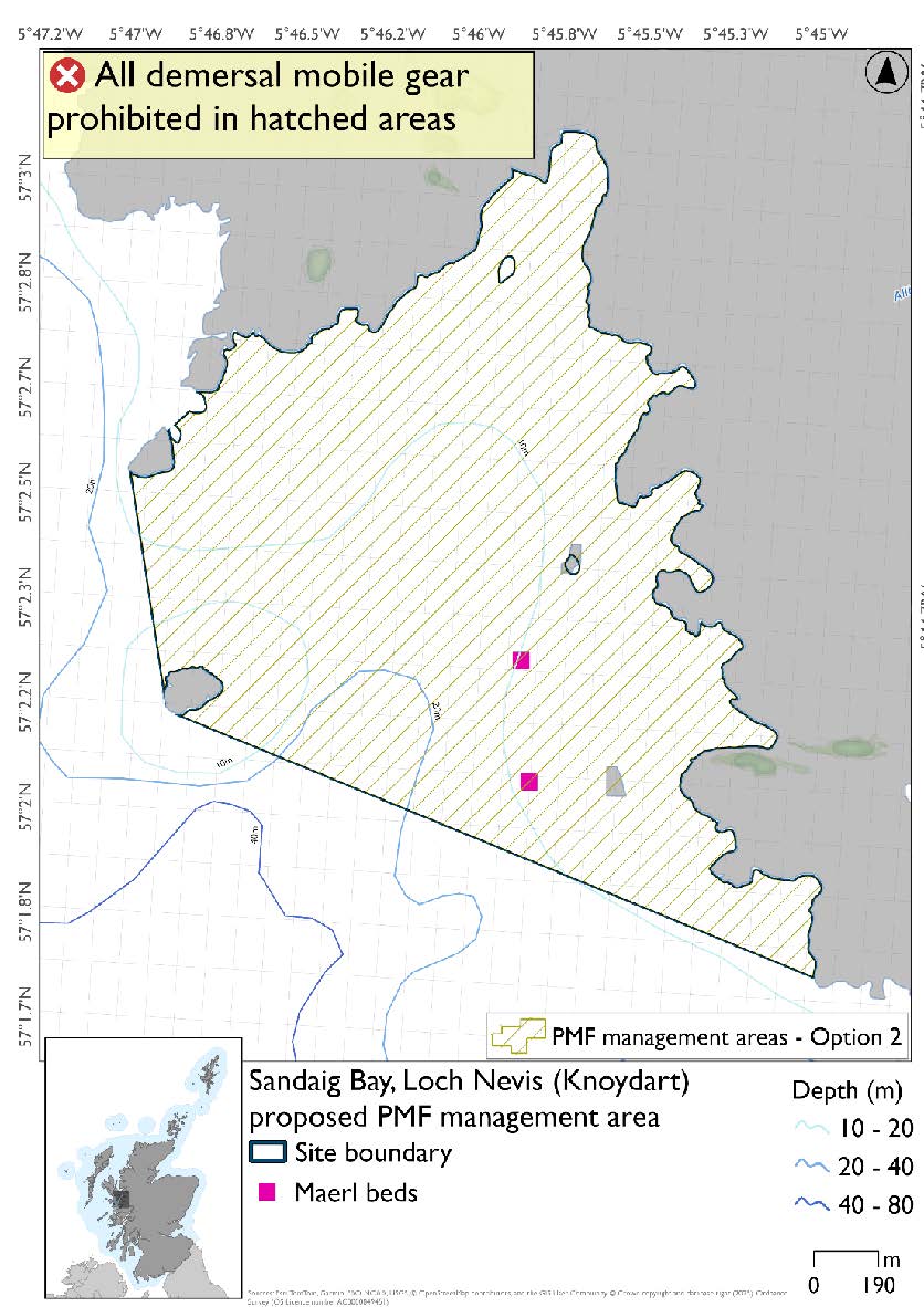
24.2.17. Area: Sandaig Bay, Loch Nevis (Knoydart)
This proposed PMF management area overlaps with the Inner Hebrides and the Minches SAC.
This PMF management area overlaps with management measures being consulted on for Inner Hebrides and the Minches SAC for set nets (not including fyke nets) which are not shown in the maps below.
Please check overlapping site map option(s) to see static gear measures.
Feature: Maerl beds
There is an additional maerl bed record outside of the boundary to the south, this is not shown in either Option because this was from a 2023 survey where data were only available after the area was finalised for consultation.
Option 1: This boundary covers a smaller footprint that includes known maerl bed records at the time of finalising the area for consultation and follows suitable depths for the habitat. Additional fishing data were provided and accommodated whilst still protecting the PMF records with buffers.
Figure 257. Map of measures proposed under option 1:
Option 2: This boundary covers a larger footprint that includes additional habitat of suitable depth in the west.
Figure 258. Map of measures proposed under option 2:
24.2.18. Area: South of Muck and Bo Fascadale
This proposed PMF management area overlaps with the Sea of the Hebrides NCMPA and Inner Hebrides and the Minches SAC.
This PMF management area overlaps with management measures being consulted on for Inner Hebrides and the Minches SAC and Sea of the Hebrides NCMPA for set nets (not including fyke nets) which are not shown in the maps below.
Please check one of the overlapping site map option(s) to see static gear measures. Both sets of maps show the same thing for overlapping portion.
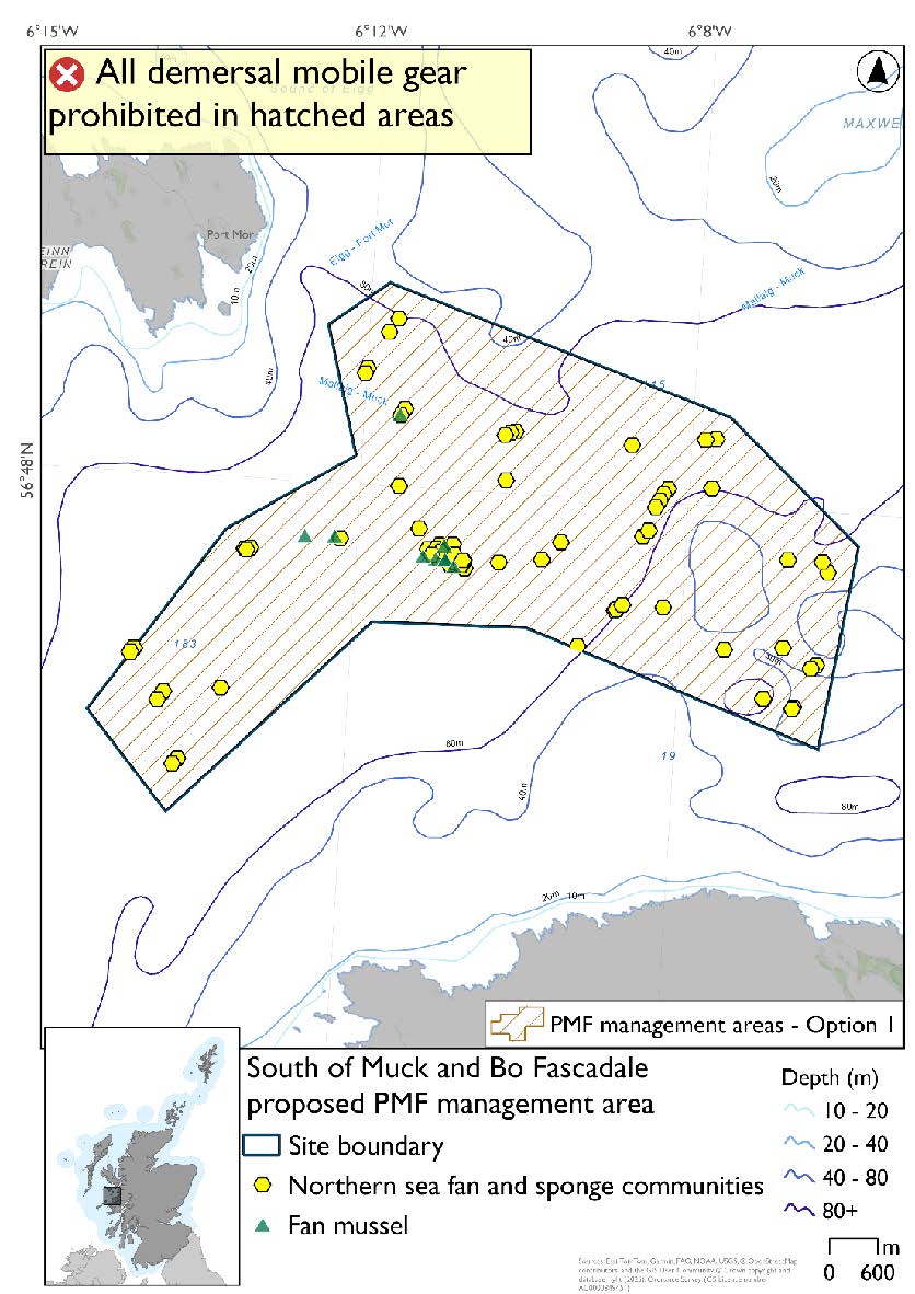
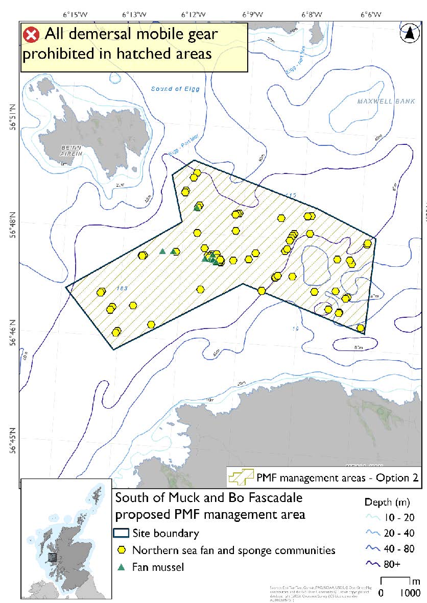
Two management areas from 2018 were joined to make this area based on new records of northern sea fan and sponge communities in this locality.
Option 2 has northern sea fan and sponge communities that were not included in Option 1. The area excluded overlaps with additional fishing data that were provided and any excluded northern sea fan and sponge communities records.
Feature: Northern sea fan and sponge communities, fan mussel aggregations
Option 1: This boundary covers a smaller footprint that excludes a few northern sea fan and sponge communities records around the margins accommodating, where possible, additional fishing data that were provided.
Figure 259. Map of measures proposed under option 1:
Option 2: This boundary covers a larger footprint that includes additional records of northern sea fan and sponge communities.
Figure 260. Map of measures proposed under option 2:
Contact
Email: marine_biodiversity@gov.scot