Shetland Islands Regional Marine Plan
This plan covers the management of the Scottish Marine Region for the Shetland Isles. It guides and supports decision making for development and use of the sea, and represents the second tier of marine planning following on from the National plan.
Section C- Productive
General Policies
There is a presumption in favour of sustainable development and use of the marine environment when consistent with the policies and objectives of the SIRMP. This approach to development is expected to contribute to the Scottish Government’s national vision for a sustainable blue economy by providing greater certainty to businesses and investors utilising the marine resource.
One of the aims of the SIRMP is to ensure marine waters are productive whilst remaining clean, safe and healthy. These aims are intrinsically linked, and one is usually reliant on the other, i.e. if waters are unclean or unhealthy, they are unlikely to be productive.
It is imperative that the SIRMP includes policies that promote and manage this productivity through sustainable development and safeguard its potential for present and future generations, whilst ensuring the use of marine waters is at a level which is sustainable and maintains good environmental status.
To achieve this goal, it is the intention of the SIRMP to promote the adoption of an integrated approach to the protection and enhancement of ecosystems.
Community wealth building should be considered within all proposals for marine development and use. Community wealth building can be defined as a people-centred approach to local economic development which redirects wealth back into the local economy, and places control and benefits into the hands of local people.[31]
Policy MP DEV1: Marine Developments
Proposals for ALL marine development and use within devolved competency should consider relevant policies in Sections Clean & Safe and Healthy & Diverse. In the Productive Section, specific consideration should be given to MP DEV1-3 and MP FISH1, in addition to the relevant sector specific policies.
Applicants should be prepared to provide supporting information to allow assessment of potential impacts.
Proposals must also ensure that there will be no adverse effects on the integrity of a European site or a proposed site.*
Applicants for marine development and use should consider:
- a) engaging in pre-application and early discussions with the relevant consenting authorities and regulators, any adjacent marine users, and local community councils where appropriate;
- b) the compatibility of the proposal with existing marine uses, including existing and consented development and use, and measures to minimise conflict and any adverse impacts;
- c) co-existence with other uses through the design and location of the proposal in order to maximise the efficient use of marine spaces;
- d) the cumulative impact of the proposal either by itself over time or in conjunction with other marine development and use; and
- e) adverse impacts on coastal processes or flooding, and the resilience of the proposal to coastal change and flooding.
*See Habitats Regulations Appraisal within the Context section for further information on the regulatory context.
Policy MP DEV2: Decommissioning of Assets
Proposals for marine development and use should, where relevant, consider the decommissioning requirements of the development to ensure the removal of redundant infrastructure. The re-use of decommissioned assets should be considered and is encouraged where practicable.
Applicants should consider, and could include within a decommissioning plan:
- a) the proposed decommissioning measures;
- b) the methods by which work will be carried out; and
- c) the timescales for the carrying out and completion of the work.
Applicants should refer to the associated SIRMP Supporting Guidance on Decommissioning.
The Scottish Government has published Offshore renewable energy: decommissioning guidance for Scottish waters to assist developers and owners of offshore renewable energy installations understand their decommissioning obligations under the Energy Act 2004.
In addition, applicants should have regard to SIRMP Supporting Guidance on Decommissioning which has been prepared to support the implementation of Policy MP DEV2. The guidance covers the type of supporting information that may be required to be submitted alongside a development proposal and the considerations that will be taken into account.
Policy MP DEV3: Development Restricted Areas
Policy DEV3 is split into two parts based on the type of development or use being proposed:
Part 1- Finfish and Shellfish Aquaculture
Finfish and Shellfish aquaculture development should have regard to Policy G4 of the Shetland Islands Council’s Supplementary Guidance on Aquaculture (2017), which sets out development restricted areas, and where relevant the Sullom Voe Harbour Area Masterplan (2022) which identifies Potential Development Zones for development in the Yell Sound area.
The Supplementary Guidance on Aquaculture (2017) sets out a general presumption against finfish and shellfish aquaculture development in the following identified areas:
- a) Fish farming will not, as a matter of policy, be permitted anywhere within the Sullom Voe Harbour Area (as defined in the Sullom Voe Harbour Revision Order 1980) for as long as its primary purpose is to accommodate vessels engaged in the carriage of hydrocarbons or other dangerous substances.*
- b) No aquaculture developments will be permitted in Whiteness Voe north of a line between Usta Ness and Grutwick or the upper part of Weisdale Voe between the Taing of Haggersta and Vedri Geo for environmental and visual reasons.
- c) No further new aquaculture developments will be permitted in Busta Voe north of a line drawn between Hevden Ness, Mainland and Green Taing, Muckle Roe as a matter of policy, and variations to existing sites north of this line should not result in either an increase in site size, a change in site location or an increase in environmental or visual impact for recreational and environmental reasons.
*The Sullom Voe Harbour Area Masterplan was adopted by Shetland Islands Council as non-statutory planning guidance in March 2022. It identifies Potential Development Zones which could suit a range of potential uses, including aquaculture (fish farming), seaweed farming and renewable energy development. The Masterplan will be a material consideration in planning and works licence decisions taken by Shetland Islands Council for development in this area.
Part 2- Other Marine Development
There should be a general presumption against proposals for other types of marine development and use in the following areas:
- a) Whiteness Voe, north of a line between Usta Ness and Grutwick where they: reduce visual amenity, or adversely impact protected habitats and species.
- b) Weisdale Voe, between the Taing of Haggersta and Vedri Geo where they: reduce visual amenity.
- c) Busta Voe, north of a line between Hevden Ness and Grain Taing where they: restrict recreational opportunity, reduce visual amenity or adversely impact protected habitats and species.
Justification and Considerations
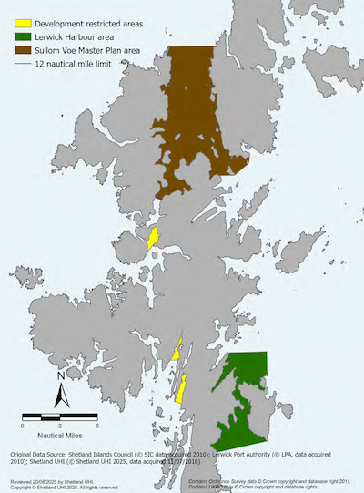
Development restricted areas, Sullom Voe Harbour Master Plan Area and Lerwick Harbour Area are shown in Map 32.
Shetland industry figures indicate that the marine economy is a mainstay for local coastal communities, with many local businesses relying on the marine environment for their livelihoods. This economic dependency should be safeguarded to protect existing local jobs and ensure economic diversity. Policies MP DEV1-DEV3 seek to promote economic growth through a well-managed and healthy marine environment which considers equality, community cohesion, well-being and health, as well as implications for the marine environment. Development and use which contribute to the overall marine environment and resource (i.e. demonstrate best practices in environmental and marine management) should be encouraged.
Policy MP DEV1 applies to all proposals for marine development and use where proposals fall within devolved competencies, and as such all applicants should be prepared to provide supporting information to allow assessment of the potential impacts identified in policies MP DEV1-3, MP FISH1, and the relevant sector specific policy. This may include information that sets out how the proposal is necessary in order to deliver social, economic or environmental benefits that clearly outweigh projected impacts.
Policy MP DEV3 reflects established policy restrictions put in place by the Shetland Islands Council to protect visual amenity, recreational opportunities and important habitats. These policies have formed part of the SIC Works Licence Policy since the 1990s (most recently incorporated into the 2017 Aquaculture Supplementary Guidance[32]) and have been further amended by the adoption of the Sullom Voe Harbour Area Masterplan in 2022.[33] The important habitats identified as nature conservation interests in the original policies include saltmarsh and seagrass beds, for which the SMMO has also implemented closed areas (see MP BIOD3 - Local Habitat Protection Areas).
Where a proposed marine development or use is identified as having a potential impact on visual amenity in the above identified areas, a Landscape and Visual Impact Assessment may be required to support a planning or works licence application to Shetland Islands Council. Guidelines for Landscape and Visual Impact Assessment have been published by NatureScot setting out the standard methodology for assessment.
Key Consultees
See Appendix A for a list of Key Consultees.
Further Information
- SIRMP Supporting Guidance on Decommissioning
- Shetland Islands Council – Community Planning and Development
- Shetland Islands Council – Business Advice and Support
- Shetland Islands Council – Community Councils
- Shetland Islands Council – Sullom Voe Harbour Area Masterplan
- Scottish Government – National Planning Framework 4
- Scottish Government – Habitats Regulations Appraisal
- NatureScot – Habitats Regulations Appraisal (HRA)
- NatureScot – Landscape and Visual Amenity Assessment
- Shetland Fishermen’s Association
- Salmon Scotland (finfish aquaculture)
- Seafood Shetland (fish processing and shellfish growing)
- Shetland Net Zero Energy Forum
- Shetland Islands Council – Harbour Master & Port Operations
- Lerwick Port Authority
- Shetland Tourism
- Shetland Shellfish Management Organisation (SSMO)
Commercial Fishing
The marine fisheries sector comprises all socio-economic activities related to the capture of wild marine organisms (fish and shellfish) and the subsequent handling and processing of catches. The Shetland catch is comprised of shellfish fisheries, and pelagic and demersal finfish fisheries.
Shetlanders have fished the waters around their islands for thousands of years and fishing remains one of Shetland’s most important industries. In Shetland, the fishing industry engages nearly 600 people in regular and irregular employment and additionally supports jobs in fish processing, transport, marketing, engineering and supply. There are over 240 active commercial fishing vessels in Shetland. Virtually all are owned by local shareholder crew, and many are based in rural areas of Shetland where there may be few alternative opportunities for economic activity. More information on the latest fishing industry statistics can be found on the Scottish Government’s Sea Fisheries Statistics webpage.
Shetland ranks as one of the UK’s most important fishing ports in terms of landings, second only to Peterhead. The islands account for a quarter of all finfish landed in Scotland and nearly a sixth of the UK’s total finfish landings, surpassing the combined landings of England and Wales.[34] As a result, conserving local fisheries is crucial for socio-economic reasons.
Policy MP FISH1: Safeguarding Fishing Opportunities
Proposals for marine development and use should consider potential impacts on fisheries and associated communities and how the proposal could safeguard fisheries by avoiding or mitigating:
- a) significant negative impacts to important fishing areas;*
- b) permanent significant obstruction to important fishing areas unless there are no reasonable alternatives;
- c) significant adverse environmental impacts to known/designated spawning or nursery areas, or habitats or species which are important for commercially important species of fish; and
- d) the creation of navigational hazards to commercial fishermen.
Proposals should further recognise the cultural importance of fishing, particularly for vulnerable coastal communities and should consider any adverse impacts on fishing areas important for those communities.
*Fishing areas may be ‘important’ in relation to the species caught, gear(s) used, the size or type of fishing vessels that operate in the area, and/or the communities where those vessels are based.
Justification & Considerations
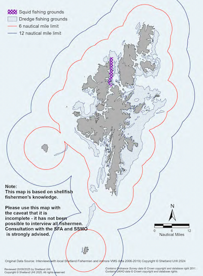
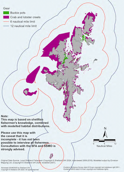
Applicants should refer to Maps 33-35 for information on important fishing grounds; however, as the distribution of fishing activity is liable to change over time, consultation and pre-application discussions with organisations and associations representing Shetland fishermen is strongly recommended for development proposals.
Policy MP FISH1 seeks to safeguard fishing opportunities and the socio-economic benefits they bring to the local economy. Marine developments can restrict access to fishing grounds and have the potential to prevent, displace and/or discourage fishing activities. They can also damage important habitats, and consequently, the commercial species that live there. The displacement of fishing effort can also cause disruption beyond the development area. Increased fishing on other grounds can place additional pressure on the viability of fish stocks.
Impacts on fisheries, fishing grounds and fish stocks may be temporary or permanent depending on the nature of the development and the degree of disturbance. The social, economic, and environmental consequences could include loss of income and loss of jobs. These impacts may have potential negative implications on local viability of the sector.
Consideration should also be given to how proposed development and use may affect fishing activity in both the short and long term, and to any cumulative effects.
It is strongly recommended that applicants:
- consider the types of fishing activity that may be affected by a proposed development or use;
- consult and discuss their proposals with local fishermen and relevant organisations on their proposals at an early stage;* and
- take account of the advice, information and views received.
Applicants are advised to engage with other marine users in areas where activity is displaced to ensure that a comprehensive picture of cumulative impacts is developed and unintended consequences are avoided. Wherever possible, applicants and decision-makers should seek to encourage opportunities for co-existence between fishing and other activities. In some circumstances, it may be possible for developments to enhance or otherwise positively influence fisheries through careful siting and design.
Industry-specific guidance documents (e.g., for offshore renewables sectors) provide guidance on potential impacts on fisheries and best practice liaison information.
*Relevant organisations include:
- Shetland Fishermen’s Association (SFA)
- Shetland Shellfish Management Organisation (SSMO)
- Shetland Regional Inshore Fisheries Group (SRIFG)
- Scottish Fishermen’s Federation (SFF)
- Scottish Pelagic Fishermen’s Association (SFPA)
Further Information
- Scottish Government – Scotland's National Marine Plan
- Scottish Government – Scotland’s Fisheries Management Strategy 2020-2030
- UHI Shetland – Scotland’s Fishing Industry – Guidance for Decision Makers and Developers. Report for Fisheries Innovation Scotland, project FIS014.
- UHI Shetland – Understanding and influencing the marine management and development processes – Best practice guidance for fishers. Report for Fisheries Innovation Scotland, project FIS014.
- NMPi – Commercial fish spawning and nursery grounds
- Scottish Government – Fisheries Sensitivity Maps
- FLOWW – Best Practice Guidance for offshore renewable development
- NatureScot – Marine Fisheries
- SeaFish
- KIS-ORCA – Offshore Renewable and Cables Awareness
- KIMO International
- DEFRA – Safeguarding our seas – A Strategy for the Conservation and Sustainable Development of our Marine Environment
Local Sustainable Fisheries Management
The Shetland fishing industry is committed to sustainability and has proactively implemented measures to reduce the potential for negative impacts on non-target species and habitats.
Within 6 nautical miles of the Shetland coast, shellfish fishing is managed by the Shetland Shellfish Management Organisation (SSMO) via the Shetland Regulated Fishery (Scotland) Order 2012. The SSMO manages fishing methods and fishing gear, restricts fishing seasons, sets minimum and maximum landing sizes for shellfish and manages shellfish beds for stock conservation. The SSMO also undertakes the collection of data allowing a comprehensive stock assessment to be developed. This allows fisheries management to be based on the best possible data and analyses.
The SSMO in partnership with the Shetland shellfish fleet has implemented a spatial management framework since 2010 prohibiting dredge fishing for shellfish in identified areas where specific Priority Marine Features (maerl, horse mussels, seagrass) have either been confirmed or are suspected of occurring. These locations were based on data provided by the Shetland Islands Marine Planning Partnership on the distribution of important seabed habitats including maerl, horse mussel beds and eelgrass. The SSMO provide wheelhouse cards to all fishermen to help them identify Priority Marine Features while at sea.
The Shetland shellfish fleet gained Marine Stewardship Council (MSC) accreditation for a number of shellfish stocks in 2012 and is an example of how the local Shetland inshore fishing industry has endorsed conservation measures to gain potential market advantage.
Whitefish and pelagic fisheries are managed nationally and internationally. However, UHI Shetland supports the local fleets in developing sustainable fishing practices. More about current research projects can be found on UHI Shetland’s Research webpages.

Aquaculture- Finfish and Shellfish
The aquaculture industry in Shetland has two major components: finfish farms and the cultivation of shellfish. The finfish and shellfish aquaculture industries are a major component of the Shetland economy, providing over 300 jobs, and further supporting jobs in fish processing, marine engineering, and transportation. Salmon is the predominant species farmed by the finfish aquaculture sector in Shetland with approximately 20% of Scotland’s farmed salmon produced in Shetland,[35] however, in the past small quantities of sea trout, cod and halibut have also been produced.
Mussel farming is the primary focus of shellfish cultivation in Shetland, with some smaller-scale production of Pacific oysters. Shetland currently produces around 80% of Scotland’s farmed mussels.[36] In 2012, rope-grown mussels produced by farms in Shetland and the Scottish mainland under the Scottish Shellfish Marketing Group became one of the first enhanced fisheries in Scotland to be MSC certified.
In 2023, the Scottish Government published its Vision for Sustainable Aquaculture. The document outlines goals up to 2045 for finfish, shellfish and seaweed farming, as well as the wider supply chain. It focuses on themes such as, sustainability and innovation, environmental limits, community benefits and climate change and nature loss, among others.
Details on the planning application process for aquaculture are included in the Legislative Context Section of this plan. Proposals for aquaculture development are considered under the scope of the Town and Country Planning (Scotland) Act 1997.[37] The Shetland Islands Council’s Local Development Plan (SIC LDP) sets out the policies and criteria against which planning applications submitted in Shetland are considered. All applications for new or modified marine and freshwater farming developments are assessed against the LDP’s Supplementary Guidance – Aquaculture Policy.
Policy MP AQ1: Finfish and Shellfish Aquaculture – Key Conditions
Applicants for finfish and shellfish aquaculture development should have regard to:
- a) Shetland Islands Council’s Local Development Plan, including Supplementary Guidance – Aquaculture;
- b) NPF4 Policy 32 (Aquaculture); and where relevant;
- c) the Sullom Voe Harbour Area Masterplan; and
- d) any Marine Directorate- Licensing Operations Team or SEPA licensing requirements and guidance.
In addition to MP DEV1, applicants should consider MP AQ2 and MP AQ3 where relevant.
Justification and Considerations
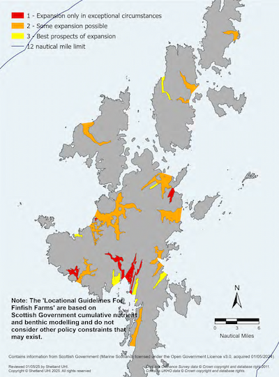
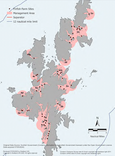
Existing finfish and shellfish aquaculture sites are shown in Map 36, Locational Guidelines area classifications are shown in Map 37 and disease management areas are shown in Map 38.
The purpose of this policy is to highlight the key conditions that restrict the placement of new finfish and shellfish aquaculture proposals as per the Shetland Islands Council’s LDP Supplementary Guidance – Aquaculture Policy. Prospective applicants should use this Supplementary Guidance while they consider the siting of the proposal as well as the SIRMP policies and maps provided.
All applications for aquaculture development should be in-line with:
- Policy CST1 Coastal Development in the Shetland Islands Council’s Local Development Plan; and
- Policy 32 Aquaculture in the Scottish Government’s National Planning Framework 4
Applicants for finfish and shellfish aquaculture developments should have regard to A Code of Good Practice for Scottish Finfish Aquaculture. In addition, finfish developers should refer to Salmon Scotland’s voluntary Protocol for Preparing Planning Applications for Aquaculture Development. All finfish and shellfish aquaculture proposals must demonstrate that anti-predator measures deter or prevent predation through the use of methods which are non-lethal and do not cause any significant harm. For the avoidance of doubt, the use of mono-filament nets for such purposes is not permitted.
Locational Guidelines area classifications are determined on the basis of predictive models developed by the Scottish Government which assess the relative sensitivity of a sea loch/voe system to additional nutrient loading by finfish and shellfish developments. As a result, there will be areas outside classification which are, or could be, sensitive to finfish and shellfish aquaculture developments but have not been specifically highlighted as they do not contain either finfish or shellfish aquaculture development presently.
Policy MP AQ2: Finfish farm Management Agreements
Applicants for finfish aquaculture developments are encouraged to seek agreement with other operators in the area to reduce the potential for disease transmission, increase fish welfare, or control and manage sea lice numbers.
This can be achieved through a Farm Management Agreement (FMA), an Area Management Agreement (AMA) or a Farm Management Statement (FMS) which:
- a) reflects (as far as possible) the recommendations of the Code of Good Practice;
- b) includes a stocking and fallowing plan; and
- c) is formally reviewed between signatories at least every 2 years.
Justification and Considerations
Finfish disease management areas are shown in Map 38.
Section 4A of the Aquaculture & Fisheries (Scotland) Act 2007 (as amended) sets out the requirement on fish farm operators to be party to a FMA or prepare and maintain a FMS and prescribes the content of the agreement or statement.[38]
Policy MP AQ3: Aquaculture Development Management Plans
Proposals for aquaculture development should give consideration to any relevant area-wide Aquaculture Development Management Plans.
Area-wide Aquaculture Development Management Plan proposals should aim to:
- a) consider separation distance between developments;
- b) reduce overall environmental impacts and/or reduce potential impact on protected species or habitats;
- c) safeguard or improve fishing opportunities;
- d) produce community benefits i.e. reduced visual impact, noise or impact on recreation/access; and
- e) increase socio-economic benefit i.e. from job creation or increased economic viability.
Justification and Considerations
Development Management Plans and Fish Farm Management Agreements are plans that adopt a holistic, multi-site approach to management which aims to bring benefits to industry and/or other users and interests. This may be through the development of disease control and prevention measures, optimizing production, minimising the impacts on the fishing industry, benefiting recreational users, the community, or natural heritage interests.
It is important that when these plans are being developed, the potential impacts both positive and negative are fully considered. It is also important that the aims of the plans are not undermined by subsequent applications. This may be of particular relevance where space for new developments has only been made available by the actions of a Development Management Plan. Conflict resolution opportunities have worked successfully in the past in Shetland (such as Yell Sound Coast SAC Seal Plan).
Further Information
- Shetland Islands Council’s – Local Development Plan and Supplementary Guidance-Aquaculture Policy
- Scottish Government – Scotland’s National Marine Plan
- Scottish Government – Vision for Sustainable Aquaculture 2023
- Scottish Government – National Planning Framework 4
- NatureScot – The siting and design of aquaculture in the landscape: visual and landscape considerations
- Crown Estate Scotland – Aquaculture Overview
- SEPA – Aquaculture Environment
- Scottish Government – Vision for sustainable aquaculture
- Scottish Government – Planning Circular 1 2007: Planning Controls for Marine Fish Farming
- Scottish Government – Fish Health Inspectorate
- A Code of Good Practice for Scottish Finfish Aquaculture
- NetRegs – Environmental Guidance for Your Business in Northern Ireland and Scotland
- Association of Scottish Shellfish Growers (ASSG) – Code of Good Practice
- SEPA Scotland’s Environment – Marine Fish Farms
- Scotland’s Aquaculture
- Scottish Government – Scotland’s 10-year Farmed Fish Health: Strategic Framework 2018
- Scottish Government– A Technical Standard for Scottish Finfish Aquaculture
- Scottish Government– Aquaculture Policy
- Scottish Government– licensing and consenting requirements

Aquaculture - Seaweed Cultivation
Seaweed is cultivated for both food and non-food uses including as a source of biofuels. Seaweed cultivation is a relatively new industry in Shetland and across Scotland, and there is continued work to develop opportunities in this field.
Species suitable for cultivation include Laminaria digitata, Saccharina latissima, Alaria esculenta, Laminaria hyperborea and Palmaria palmata, all of which are Shetland native species. Seaweed production requires high nutrient levels and good water quality. One of the main benefits of seaweed cultivation is that seaweed, being a primary producer, does not require feed. Seaweed can also be beneficial to the local marine environment by increasing local fish populations through the provision of shelter and food for herbivorous fish and acting as a ‘nutrient sink’ by taking up inorganic nutrients from the water.
Policy MP SWD1: Seaweed Cultivation
Applicants for the development of a seaweed cultivation site should have regard to the Scottish Government’s Seaweed Cultivation Policy Statement.
Proposals should only cultivate seaweed species native to Shetland and should identify biosecurity measures where relevant. The artificial enrichment of the marine environment to aid production should be avoided. Where relevant, applicants should consider how the proposal contributes towards integrated multi-trophic aquaculture.
Applicants should refer to the associated SIRMP Supporting Guidance on Marine Biosecurity.
Justification and Considerations
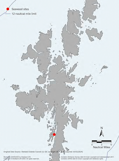
Seaweed cultivation sites are shown in Map 39.
The Scottish Government’s Seaweed Cultivation Policy Statement 2017 provides an overarching framework for the management and regulation of seaweed cultivation in Scottish territorial waters (0-12nm) and facilitates the sustainable development of the seaweed cultivation industry in Scotland. Additionally, the Scottish Government’s Vision for Sustainable Aquaculture 2023 outlines goals up to 2045 and encourages the growth of seaweed production as a sector, as well as supporting the development of multi-trophic aquaculture. The co-existence of seaweed cultivation should be explored in relation to other aquaculture uses and marine renewable energy developments. The Scottish Government recognises the potential for synergies to exist between these sectors and continues to work with the industry to ascertain possibilities in this regard. The SIRMP supports these objectives, encouraging the sustainable development of seaweed cultivation and harvesting in harmony with other marine developments and activities, where there are no significant adverse impacts on the environment, other marine users and their operations.
It should be noted that seaweed cultivation does not require planning permission from the Shetland Islands Council but does require a works licence issued by the Shetland Islands Council (or the LPA in Lerwick Harbour) as well as a marine licence and a Crown Estate Scotland lease.
Further Information
- SIRMP Supporting Guidance on Marine Biosecurity
- Scottish Government – Seaweed Cultivation Policy Statement 2017
- Scottish Government – Vision for Sustainable Aquaculture 2023
- Scottish Government – Scotland’s National Marine Plan
- Shetland Islands Council – Local Development Plan
- Shetland Islands Council – Works Licence Policy
- NatureScot – The siting and design of aquaculture in the landscape: visual and landscape considerations.
- NatureScot – Standing Advice for Seaweed Aquaculture (farming/cultivation)
- Crown Estate Scotland – Aquaculture Overview
- BioMara Research
Integrated Multi-Trophic Aquaculture
Integrated Multi-Trophic Aquaculture (IMTA) involves the integration of fed cultivated species (e.g., finfish) together with extractive species (marine invertebrates and/or seaweed). The extractive species feed on the waste products generated from the fed species.* This creates a more balanced system for greater efficiency in resource use: feedstuffs, space, labour and a reduction in the adverse environmental impact of the aquaculture process.
IMTA can be undertaken offshore with the use of buoys with lines on which the seaweed grows and placed adjacent to fish cages where the fish are grown. This method is currently used commercially in Canada and is under development in Norway, Scotland and Ireland. In a typical IMTA set-up, finfish occupy higher trophic levels whereby they excrete soluble ammonia and phosphorus. Seaweeds and similar species can extract these inorganic nutrients directly from their environment. Finfish also release organic nutrients which feed shellfish species.
For more information on Scottish IMTA see the Scottish Government’s Seaweed Cultivation Policy Statement 2017.
*Alexander, K.A. and Hughes, A.D. (2017). A problem shared: Technology transfer and development in European integrated multi-trophic aquaculture (IMTA). Aquaculture. 473: pp. 13-19.
Oil and Gas
The oil and gas industry makes a significant contribution to the economy of Shetland with the Sullom Voe Oil Terminal and Shetland Gas Plant both based in the north of Shetland. Shetland is also strategically located to service and support the offshore industries' decommissioning activity in the northern and central North Sea, as well as to the west of Shetland. Lerwick Harbour has become Shetland’s main decommissioning area and the Lerwick Port Authority is seeking to expand these facilities.
Unique to Shetland, a works licence from Shetland Islands Council is required for oil and gas exploration activity and associated developments within 12 nautical miles of the coast or from the Lerwick Port Authority within Lerwick Harbour.
There are a number of environmental risks and potential adverse impacts associated with oil and gas extraction. The most notable of these being the risk of oil spill, noise from exploration (e.g., seismic survey) and production, historical oil-based cutting piles, and inputs of exploration and production chemicals. Sites within 12 nautical miles of the coast have little or no time to contain spills before they reach the shore. The impacts of pipeline installations on seabed and coastal habitats will depend on location, size and the manner of installation. However, these impacts are generally localised, minor and short-term relating to noise and disturbance impacts.
Existing oil and gas infrastructure is shown in Map 40.
Further Information
- Scottish Government – Scotland’s National Marine Plan
- Shetland Islands Council – Local Development Plan
- Scottish Government – National Planning Framework 4
- The North Sea Transition Authority (NSTA)
- Maritime and Coastguard Agency
- IMO – Guidelines and standards for the removal of offshore installations and structures on the continental shelf and in the EEZ. (1989)
- NatureScot – Oil and Gas
- Fisheries and Offshore Oil Consultative Group – A Fishing Industry Guide to Offshore Operators
- Shetland Decommissioning
- Lerwick Port Authority – Decommissioning

Renewable Energy
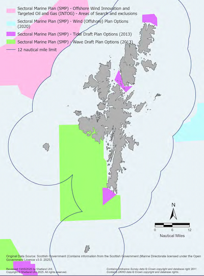
The Scottish Government’s Sectoral Marine Plan for Offshore Wind Energy (2020) identifies sustainable options for the development of commercial-scale offshore wind energy in Scotland. The plan is part of the Scottish Government’s broader strategy to harness Scotland’s significant offshore wind potential and support a green recovery and sustainable future. Within the Sectoral Plan, one area (NE1) has been identified to the east of Shetland. The agreements for leases within these Plan Option areas have been issued by Crown Estate Scotland via the Scotwind leasing round[39] and proposals to develop offshore windfarms in this area are now progressing.
In 2022, the Scottish Government published the Sectoral Marine Plan Offshore Wind for Innovation and Targeted Oil & Gas Decarbonisation (INTOG) to support the development of offshore wind projects that directly reduce emissions from oil and gas production and promote further innovation in Scottish waters. The INTOG leasing round was unique as it combined the goals of reducing emissions from the oil and gas sector with stimulating innovation in offshore wind energy. In Shetland one area was identified to the northwest of Shetland bordering the 12nm limit.
Policy MP NRG1: Renewable Energy Development Proposals
- Proposals for renewable energy development should consider potential impacts to the safety or amenity of any sensitive receptors. Applicants should further consider:
- a) how the proposal contributes to regional or local community wealth building strategies;
- b) how the proposal aligns with the Shetland Islands Council Energy Development Principles;
- c) any associated infrastructure required to service the site including connections to the electricity grid if relevant;
- d) an appropriate monitoring programme specific to the design, scale and type of development; and
- e) any relevant sectoral marine plans and associated regional locational guidance to identify areas of low known constraint.
Justification and Considerations
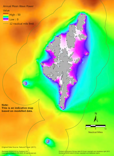
Potential wave and tidal resource around Shetland are shown in Maps 41 and Map 42. Scottish Government sectoral marine plan wave, tide and offshore wind option areas are shown in Map 43.
Increasing development of marine renewable resources is imperative to facilitate the delivery of international and national commitments on greenhouse gas emissions and renewable energy, as well as climate change mitigation. Marine renewable energy development has the potential to create significant community benefits, as well as contributing to Shetland’s wider sustainable economic development.
Despite the obvious advantages of renewable energy, it is also important to ensure that the Shetland environment, existing industries and the quality of life of residents is not compromised. Shetland Islands Council have approved a set of Shetland Energy Development Principles which are promoted to all existing and prospective energy developers, UK and Scottish Governments, their agencies and relevant regulators. These principles set out objectives and priorities for community benefit packages, local supply chain opportunities, protecting Shetland’s marine environment and existing economic sectors among others.
In addition, applicants are strongly advised to engage with Shetland Islands Council Marine Planning Team, NatureScot, local industries (especially fisheries) and the local community in the early stages of the project design.
The Scottish Government have provided guidance on the Offshore renewable energy: decommissioning guidance for Scottish waters.
Further Information
- Scottish Government – licensing and consenting requirements
- Scottish Government – Scotland’s National Marine Plan
- Scottish Government – Offshore wind, wave and tidal energy applications: consenting and licensing manual
- Scottish Government – Sectoral Marine Plan for Offshore Wind Energy
- Scottish Government – Offshore wind energy - draft updated Sectoral Marine Plan: regional locational guidance
- Scottish Government – Sectoral Marine plan- offshore wind for innovation and targeted oil and gas decarbonisation: initial plan framework
- Scottish Government – Marine renewable energy
- Scottish Government – National Planning Framework 4
- Shetland Islands Council – Local Development Plan
- Shetland Islands Council – Shetland Energy Development Principles
- Low Carbon Scotland – meeting the emissions reduction targets 2013-2027
- Department for Energy Security and Net Zero – Powering up Britain
- NatureScot – Marine Renewables
- Shetland Net Zero Energy Forum
- Wave and Tidal Consenting Position Paper – Marine Mammal Impacts
- Wave and Tidal Consenting Position Paper – Ornithological Impacts

Marine aggregate extraction
Marine aggregate extraction is the process of taking sand, gravel and shingle from the seabed for use as construction aggregate (principally for concrete production), or for providing sand and gravel for land reclamation. Traditionally, the industry in Shetland and in Scotland generally, has been very small due to an adequate land supply, and a lack of suitable and easily accessible resources on the seabed.
Shetland’s coastal sediment stores, which currently provide a natural coastal defence role, are limited and unlikely to be replenished. Unlike mainland Scotland, where glacially derived sediments are found in river terraces and other features, in Shetland these sediments are below sea level. Since the last ice age 13,000 years ago, Shetland has experienced rising sea levels which have had a profound effect on the coastline and location of marine sediment stores. This submergence has left very little of the ‘old’ coastal zone, where these sediments would remain, resulting in the current finite stores.
Policy MP EX1: Extraction of Sand, Gravel and Shingle
Proposals for the extraction of sand, gravel or shingle from below the Mean High Water Spring (MHWS), including coastal quarrying, should consider whether sand/gravel extraction is an essential part of the proposed project. Applicants should consider the use of alternatives, including:
- a) alternative sources (both within and outside Shetland - bearing in mind the most sustainable option may actually be sourced material from outside Shetland);
- b) alternative materials, such as recyclate or secondary aggregate;
- c) using dredged material.
Where extraction operations are proposed, the physical effects of the operation and its implications for coastal erosion should be considered.
Justification and Considerations
The purpose of this policy is to protect Shetland’s seabed and coastline from damaging extraction. The extraction of marine aggregate primarily impacts the seabed, bottom substrate and associated benthic communities that burrow below the surface of the deposits, sometimes to depths of more than 10cm.
The extraction of sand, gravel, or shingle can have far-reaching effects beyond the immediate extraction site if it disrupts the natural movement of sediment along the coastline. This disruption can increase flood risk by altering sediment supply and beach profiles. Quarrying active beach material diminishes the beach’s ability to withstand storm events. Research into sediment supply in open beach environments indicates that even a slight decrease in lateral sediment supply (e.g., a 0.1% reduction in sediment from adjacent beach sections) would lead to erosion rates similar to those caused by a 0.5m rise in mean sea level.
Crown Estate Scotland own the material rights to the seabed extending to the edge of the UK continental shelf, and issue agreements for non-exclusive sampling and commercial aggregate extraction.[40] The planning, licensing and consenting process is the responsibility of the Marine Directorate- Licensing Operations Team.
Shetland Islands Council license the extraction of sand, gravel and shingle, and coastal quarrying under the Zetland County Council Act 1974 and license dredging below MHWS and out to 12 nautical miles in all areas except the Lerwick Harbour area (under the jurisdiction of the Lerwick Port Authority).[41]
Further information
- Scottish Government – Scotland’s National Marine Plan
- Mineral Resources of Scottish Waters and the Central North Sea
- Ware, S.J. & Kenny A.J. (2011). Guidelines for the Conduct of Benthic Studies at Marine Aggregate Extraction Sites (2nd Edition). Marine Aggregate Levy Sustainability Fund, 80 pp.
Tourism
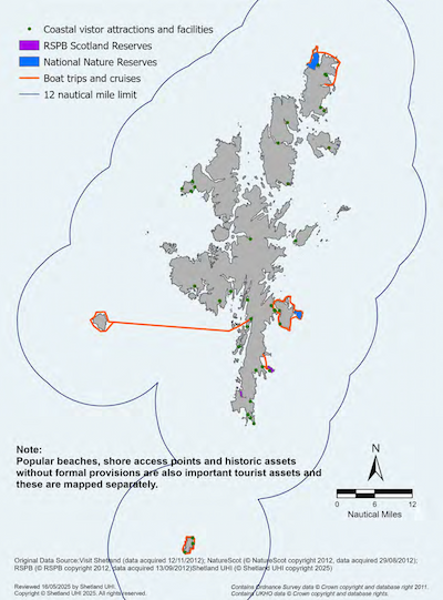
The special qualities the Shetland Islands provide as a tourist destination are primarily the large areas of unspoilt wildness, its potential for marine recreation, and its cultural and environmental assets. The mixture of formal and informal activities organised by individuals, clubs or commercial ventures takes advantage of some of the most attractive coastal scenery and most demanding marine conditions in Europe. As an island community, Shetland has always relied heavily on the sea; as a result, it has been well looked after and the facilities available for recreational users and visiting boats are excellent.
Marinas and piers often form important hubs for local Shetland communities. There are visitor berths at most of the 23 marinas and 300 points of access to the shore in the form of jetties, piers and slipways. Yachting also takes prominence; there are numerous regattas held every year throughout the Islands, as well as the annual international Bergen-Shetland Races.
Tourist activities and leisure facilities around the coast of the Shetland Islands provide the opportunity for a wide range of commercial ventures generating an important income for the local economy.
Policy MP TR1: Tourism and Leisure Developments
Proposals for marine-related tourism and leisure development and use should consider how they can promote employment opportunities, community benefits, community wealth building, and rural diversification in a sustainable manner.
Proposals should consider the potential for sharing and enhancing existing infrastructure with other marine users.
Justification and Considerations
The purpose of this policy is to promote sustainable tourism in Shetland without damaging the resource on which it is based. Clean, safe and healthy seas are fundamental to a successful marine tourism and leisure industry in Shetland. It is the general intention of the Shetland Islands Council to conserve the character of the coast and protect it, and its surroundings, from development which may be detrimental to this character.
It is strongly advised that developers and consenting authorities engage with local tourism stakeholders, tourism destination management organisations, heritage and environmental management bodies and other marine and coastal users early in the development proposals and before any decisions are taken forward.
Licence requirements will be specific to the development type. Developers should contact MD-LOT and the Shetland Islands Council to determine licence requirements.
The diversity of tourism assets and opportunities is included on Map 44. Marine recreation is also a tourism asset and includes: SCUBA diving, sea kayaking, sailing, yacht events, fishing, sea angling and coasteering as shown in Map 30. Shore access points are shown in Map 4 and Map 31.
Further information
- Scottish Government – Scotland’s National Marine Plan
- Scottish Government – National Planning Framework 4
- Shetland Islands Council – Local Development Plan
- Visit Scotland – Shetland
- Promote Shetland – Tourism Information
- Shetland Museum and Archives
- NatureScot – Scottish Marine Wildlife Watching Code
- Royal Yachting Association Scotland
Infrastructure and Services – Shore Access and Moorings
Shore access is defined here as including piers, jetties, slipways, marinas and their access tracks. There are very few single mooring point agreements in Shetland. The majority of boats are kept in small community marinas.
Policy MP SA1: Shore Access and Moorings
Proposals for shore access developments and/or moorings should consider:
- a) the impact of increased access and traffic at sea and on land;
- b) the implications for existing users and planned future use; and
- c) the likelihood of increasing erosion or tidal inundation.
Proposals should consider identifying relevant mitigation measures to address these impacts.
Shore development proposals are encouraged in locations where activity already exists. The mooring of individual boats is encouraged at designated marinas and ports.
Justification and Considerations
The purpose of this policy is to protect the character of the coastal zone from inappropriate development. In addition, its purpose is to direct development requiring a coastal location to areas with existing development, or to sites where the character of the coastal zone may accommodate such a development. Developers should be aware of the need for compliance with the Shetland Islands Council’s Local Development Plan.
Poorly placed moorings can disrupt and hinder other marine activities and functions. The cumulative impacts of numerous mooring chains could impact benthic habitats. For this reason, the mooring of boats is encouraged at designated ports and marinas which are designed and sited to integrate with the landscape and complement the character and scale of the surrounding area.
Proposals should consider the potential impacts of climate change. Globally, it is likely that sea levels will rise over the next hundred years, and storm events will become more severe. It is estimated that sea level rise in Shetland will be 1.02m by 2100.[42] In addition, storm surges of 1.5 metres have already been recorded. This change in sea level will have consequences for all existing and proposed jetties, piers, and marinas.
Licence requirements will be specific to the development type. Developers should contact MD-LOT and the Shetland Islands Council to determine licence requirements.
Shore access points are shown in Map 4 and Map 31.
Further information
- Shetland Islands Council – Local Development Plan
- Scottish Government – Scotland’s National Marine Plan
- Scottish Government – National Planning Framework 4
Infrastructure and Services- Cables, Pipelines and Sea Outfalls
Utility Cables and Pipelines
A number of water pipelines, oil and gas pipelines, telecommunication cables, and power submarine cables exist within the Shetland Marine Region, forming a vital part of the Islands’ socio-economic infrastructure. Power and telecommunication cables provide lifeline services to communities in the islands around Shetland.
New utility cables and utility pipelines should have regard to Policy MP ACBP1: Avoidance of Cables and Pipelines (Policy Section A).
Policy MP CBP1: Placement of Electricity and Telecommunications Cables, and Water Pipelines
Proposals for the laying or replacing of electricity and telecommunication cables, and water pipelines should consider seasonal sensitivities for marine habitats and species and impacts on landing points and existing land use.
Where possible, cables and pipelines should use existing routes and landing points or identified cable corridors.
Justification and Considerations
Developers have numerous methods and innovative approaches available to them when engineering the route for the placement of cables and pipelines. This policy aims to ensure that developers consider all possible options during the planning process.
The consenting of submarine cables between MHWS and 12 nautical miles requires a marine licence. A local works licence is also required from Shetland Islands Council from the MHWS out to the 12 nautical mile limit, and from the Lerwick Port Authority within Lerwick Harbour.
Applicants are encouraged to contact NatureScot early in the application process to seek guidance on any seasonal sensitivities within the proposed development area that may impact marine species and habitats, for example, areas where species aggregate at specific times of year for mating or nesting.
Further Information
- Scottish Government – Scotland’s National Marine Plan
- Scottish Government – National Planning Framework 4
- Shetland Islands Council – Local Development Plan
- Shetland Islands Council – Works Licence Policy
- European Subsea Cables Association Guidelines
Sea Outfalls
Sea outfalls are pipelines that discharge wastewater or storm water run-off into the sea. Discharges of foul and/or surface water which require a sea outfall will need a works licence from the Shetland Islands Council, where the discharge pipe will be below Mean High Water Springs (MHWS). All outfalls in Scotland are subject to strict environmental controls to ensure minimal impact on the marine environment.
Policy MP CBP2: Sea Outfalls - Placement of New Domestic and Trade Wastewater Pipelines
Proposals that require a works licence from the Shetland Islands Council for the laying of new wastewater pipelines with sea outfalls may be required to demonstrate to the Shetland Islands Council that:
a) there are no practicable alternatives:
- i. a public wastewater system is not already present;
- ii. a suitable soakaway is unachievable;
b) the seaward end of the pipe will be sited well below the MLWS; and
c) there will be no adverse impact on any other marine structure or development.
Justification
The purpose of this policy is to ensure that wastewater drainage arrangements, where permitted, are properly sited and have no public health or pollution impacts on the surrounding area, and in areas served by wastewater schemes, new developments are connected to the existing system.
Current Shetland Islands Council guidance on the placement of wastewater pipes stipulates that they extend to below the tide level at MLWS and comply with dilution requirements. Engineering works below MHWS may require a marine licence. SEPA are responsible for the registration of private discharges and provide information on assessing if discharges are within bathing or shellfish waters. Although there are no specific buffer zones placed around aquaculture sites, discharges directly to or impinging on Identified Waters may require further mitigation.
Further Information
- Shetland Islands Council- Works Licence Policy
- Shetland Islands Council- Local Development Plan
- Scottish Government- Scotland’s National Marine Plan
- Scottish Government - National Planning Framework 4
- SEPA - Water Regulations
Infrastructure and Services – Commercial Moorings
Commercial moorings are structures attached to the seabed which can hold: individual boats, weather and radar masts, and buoys.
Policy MP MO1: Commercial Moorings
Proposals for commercial mooring structures or the licence renewal of existing structures should consult with the appropriate harbour authority, regulatory or advisory body and should further consider:
- a) if the need can be met by existing moorings or infrastructure;
- b) if there are other practical alternatives, such as the potential for sharing and enhancing existing infrastructure with other marine users; and
- c) the implications for other marine users and planned future use.
Justification and Considerations
Commercial moorings support important commercial activities and can reduce the need for anchoring which can damage the benthic environment. However, sporadically placed moorings can disrupt and hinder other marine activities and functions. The cumulative impact of numerous mooring chains could impact the environment and other marine users.
Lerwick Port Authority or Shetland Islands Council require works licence applications for commercial moorings and it is strongly advised that any applicant considering such development consult with them, along with MD-LOT as the consenting authority for marine licences, and Crown Estate Scotland for seabed leases.
Further information
- Shetland Islands Council - Works Licence Policy
- Scottish Government – Scotland’s National Marine Plan
- Lerwick Port Authority
Infrastructure and Services - Coastal Defence
Climate change and sea level rise are leading to more coastal erosion and flooding across Scotland. Dynamic Coast, Scotland’s national coastal change assessment, identified past and current coastal change and erosion, and quantified the level of protection from natural and artificial defences. The main source of flooding in Shetland is from coastal flooding, including high tides, storm surges and waves, which accounts for approximately 80% of the annual average damage by flooding.[43]
The Shetland Islands Council publishes the Shetland Local Flood Risk Management Plan. It outlines the various responsibilities and actions of the relevant agencies, including SEPA, Scottish Water and the Shetland Islands Council, to manage and, where achievable, reduce overall flood risk in Shetland. The plan identifies Potentially Vulnerable Areas, including those where buildings and infrastructure may be at risk from coastal flooding. In due course a Coastal Change Adaptation Plan will also be developed which will improve understanding of coastal flood risk and erosion and help develop adaptation and mitigation measures. Primary responsibility to protect land lies with the landowner who may undertake flood prevention works, or coast protection works, with the written consent of the Coast Protection Authority (which is Shetland Islands Council). All activities and developments must be resilient to the risks of coastal change and flooding and should not have an unacceptable impact on coastal change.
Coast Protection Authorities can promote appropriate schemes on land not in their ownership when the need for coast protection works or flood prevention works (for non-agricultural land) is deemed necessary.[44] Such schemes require ministerial approval regardless of size.
Coast Protection Authorities are permitted to undertake maintenance and repair work under Section 12 of the Coast Protection Act 1949 and have powers to carry out emergency coastal defence works.
Policy MP CD1: Coastal Defence Construction
Proposals for the construction of flooding or coastal defence developments which may require a Marine Licence or Works Licence should consider:
- a) the consistency of the proposal with relevant coastal plans;
- b) using nature-based solutions that allow for managed future coastal change wherever practicable; and
- c) how any in-perpetuity hard defence measures can be demonstrated to be necessary to protect essential assets.
Applicants should have regard to the relevant policies within the NPF4 and should further consider:
- a) relocation options for the threatened infrastructure or development;
- b) the risks and impacts of construction to ecological characteristics, landscape character or popular coastal views and how these features can be retained or enhanced through design; and
- c) the wider implications of exacerbating flooding or coastal erosion, and mitigating potential impacts.
Policy MP CD2: Coastal Defence Demolition
Proposals for the demolition of coastal defences should consider potential impacts on the natural and built environment, coastal processes, and climate change related risks and impacts including those associated with sea level rise projections.
Applicants should further consider:
- a) the historic value of the structure in its surroundings;
- b) the potential to re-use the material;
- c) implications for reinstatement; and
- d) the value of the structure to species and habitats, such as providing a substrate for an important rocky shore habitat, or shelter for European otters.
Justification and Considerations
All coastal defence developments should have regard to the relevant policies within NPF4. The installation of flood defences should consider the needs of public health and safety as well as the wider implications of the work and the potential environmental effects. Licence requirements will be specific to the development type and the nature and scale of works.
As a result of cliff and beach erosion and post-glacial relative sea level rise the shoreline of Shetland is naturally receding. Shetland’s outer coastline is formed of hard rock and is thus less susceptible to coastal erosion. However, Shetland’s more limited softer coastal features are susceptible to erosion due to sea level rise, a severe wave environment and restricted supply of sediment. Coastal defence actions can restrict sediment supply and worsen erosion of soft coastal features such as beaches by altering coastal processes such as wave dynamics.
Traditionally, and due to the characteristics of our coastline, many of the defences used against erosion have consisted of ‘hard engineering’ works. Hard coastal defence works include dykes and groynes, rock armour, seawalls and gabions.
Where practical ‘soft engineering’ works are now promoted more widely as a sustainable way to manage coastal erosion. Soft coastal defence works include natural flood risk management and nature-based solutions, such as beach nourishment and beach re-enforcement by dune fencing, recharging, planting Marram grass, etc.
Further Information
- Scottish Government – National Flood Resilience Strategy
- Scottish Government – Climate Change: Scottish National Adaptation Plan (2024 – 2029)
- Scottish Government – Climate Change
- Scottish Government – Scotland's National Marine Plan
- Scottish Government – National Planning Framework 4
- Shetland Islands Council – Flood, drainage and coast protection
- Shetland Islands Council – Local Development Plan
- Shetland Islands Council – Strategic Flood Risk Assessment
- Shetland Islands Council – Local Flood Risk Management Plan
- SEPA- Flood Risk Management Strategy
- SEPA- Flood Risk Management Plan: Shetland Local Plan District
- SEPA- Flood Risk and Land Use Vulnerability Guidance
- UK Climate Change Projections
- UK Climate Change Risk Assessment (CCRA)
- The UK Climate Impacts Programme
- Dynamic Coast – Scotland’s Coastal Change Assessment
- Marine Climate Change Impacts Partnership
Transport
Marine transport by ship refers to the transportation of both freight and passengers, whether for commercial or recreational purposes. Marine transport is supported by a diverse range of ancillary activities including shipbuilding and repair, the construction of ports and marinas, and activities associated with navigation, including dredging. Marine transport is a significant contributor to national and regional economics, acting as a major intermediary for Scottish and Shetland imports and exports. Ports and harbours also provide key transport infrastructure between land and sea.
Marine transport in Shetland is very important both economically and socially, with the marine transport industry and Shetland Islands ports and harbours supporting hundreds of jobs. International trade through Shetland’s ports is also important for sustaining modern island living, in terms of distribution of raw materials such as fuel and construction materials, as well as other goods not available naturally or locally on the Islands.
Ports and harbours also play a significant role in domestic freight and passenger travel through the provision of infrastructure and facilities which support lifeline ferry services to island communities. Their role is crucial not only in supporting the projected future growth of freight traffic but also in supporting more fragile and remote communities.
Ports and harbours in Shetland have long supported the oil and gas, and fisheries sectors. In more recent years, they have also played a key role in supporting the marine renewable energy industry.
Policy MP TRANS1: Port and Harbour-related Development
Proposals for port and harbour-related development and use should consider potential adverse impacts on the natural and built environment, coastal processes, and climate change related risks and impacts including those associated with sea level rise projections.
In addition to MP DEV1, proposals should consider MP CD1 and MP DD1 where relevant.
Justification and Considerations
Port and harbour areas are shown in Map 4, and the main shipping and ferry routes are included in Map 5. Positive impacts from port and harbour-related development include job creation and benefits to local communities, as well as having national, regional or local economic benefits.
Potential adverse impacts from the development of new ports and harbours are similar to those from any coastal development and will primarily result from the construction phase. These negative impacts will vary depending on the local conditions, ecosystems and other factors but might include:
- impacts to local hydrodynamic and sedimentary regimes;
- loss of intertidal habitat;
- disturbance of historical contamination during capital dredging works;
- impacts on migratory and/or juvenile fish;
- impacts on important bird species; and
- impacts on heritage assets.
Port development may also result in associated impacts during the operational phase, such as increases in shipping traffic and maintenance dredging.
Policy MP TRANS2: Future Fixed Links/Ferry Terminals
Proposals for the construction of fixed-link developments and new ferry terminals should consider potential adverse impacts on the natural and built environment, coastal processes, and climate change related risks and impacts including those associated with sea level rise projections.
In addition to MP DEV1, proposals should consider MP CD1 and MP DD1 where relevant.
Proposals must consider adverse effects on existing or proposed European sites, including:
- Yell Sound Coast SAC
- Sullom Voe SAC
- Bluemull and Colgrave Sounds SPA
- East Mainland Coast SPA
Justification and Considerations
Whilst consideration is currently being given to the replacement of one or more of the ferry services with fixed links, the inter-island ferry service will continue to be the main lifeline link to the isles. Ferry terminals are shown on Map 4 and ferry routes have been included on Map 5; however, it is most likely that any future fixed links will be located close to the shortest crossing points. Policy MP TRANS2 aims to make developers and users of marine and coastal areas aware of the possibility of fixed-link developments.
Potential port and harbour related developments including potential fixed links or ferry terminals will need to consider relevant policies within the NPF4.
Further Information
- Scottish Government – Scotland’s National Marine Plan
- Scottish Government – National Planning Framework 4
- Shetland Islands Council – Local Development Plan
- Shetland Islands Council – Works Licence Policy
- ZetTrans – Shetland’s Transport Strategy Refresh
- Transport Scotland – Ports and Harbours
- SEPA – Water regulations
- Lerwick Port Authority
Dredging and Deposit
Dredging and the marine deposit of dredged material are activities necessary for the viability of the marine shipping industry of the Shetland Islands. Without adequate depths within harbours, shipping and trade would be severely restricted. Both dredging activity and the deposit of dredged material in the sea have the potential to cause long-term environmental impacts, affecting marine life, the fishing industry and other marine users. Sustainable management of the activity is needed to minimise potential harm.
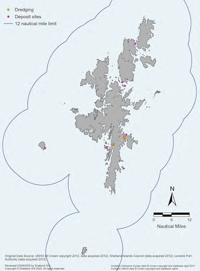
Certain sea deposit operations are licensed annually as major ports require an annual maintenance dredge. Other ports undertake dredging operations when required, either to maintain channels or berths or in connection with construction works to upgrade or replace existing port facilities.
Policy MP DD1: Dredging and Deposit of Dredged Material
Proposals for the dredging and deposit of dredged material should consider:
- a) the use of recognised marine deposit sites where possible;
- b) assessing the suitability of the dredge material for sea deposit including contamination levels; and
- c) the level of impact from suspension of materials and disturbance to the seabed.
Proposals must consider adverse effects on existing or proposed European sites. Existing deposit sites in or adjacent to European sites include:
- Ulsta or Samphrey – the Yell Coast SAC or East Mainland Coast SPA
- Foula – Foula SPA or Seas off Foula SPA
- Bluemull Sound – Bluemull and Colgrave Sound SPA
- Lerwick Harbour area – East Mainland Coast SPA
Justification and Considerations
Many of the voes in Shetland which are used by large vessels are naturally deep and therefore have never required dredging operations. However, dredging has occurred in Lerwick and Scalloway harbours, as indicated on Map 45.
The removal and deposit of marine dredged material at sea requires a marine licence under the Marine (Scotland) Act 2010. Shetland Islands Council can permit dredging under the Zetland County Council Act 1974 by issuing a dredging licence in all areas except the Lerwick Harbour area.[45] In the Lerwick Harbour area consent for dredging and deposit will require a works licence from the Lerwick Port Authority.
Maintenance dredging, under certain circumstances, is exempt from requiring a marine licence. However, this exemption is subject to certain conditions and approval and only applies to dredging activity, not to the deposit of the dredged material which will require a marine licence for deposit sites. The UK Marine Policy Statement 2011 requires the re-use, recycling or treatment of dredged waste over depositing, where there are no undue risks to either human health or the environment, or disproportionate costs.[46] It should be noted that the depositing of dredged material to land for beneficial use is also an option. Such proposals need to be registered with SEPA under a waste management exemption. The ‘Best Practicable Environmental Option Assessment’ (BPEO)[47] should be used to determine whether there are practicable alternatives to sediment deposit.
Further Information
- Scottish Government – Licensing and consents
- Scottish Government – Scotland’s National Marine Plan
- Shetland Islands Council – Local Development Plan
- UK Marine Policy Statement
- Revised OSPAR Guidelines for the Management of Dredged Material
- SEPA – Activities exempt from waste management licensing
- Scottish Government – Marine and fisheries (Provide monitoring and advice on fisheries impacts of extraction activities with real time monitoring and modelling sediment plume density and dispersion for impact assessment before, during and after extraction.)