Shetland Islands Regional Marine Plan
This plan covers the management of the Scottish Marine Region for the Shetland Isles. It guides and supports decision making for development and use of the sea, and represents the second tier of marine planning following on from the National plan.
Context
Introduction
In Shetland, the process of developing a regional marine plan has been delegated by Scottish Ministers to Shetland Islands Council (SIC) and Shetland UHI (formally the NAFC Marine Centre UHI). Shetland Islands Council and Shetland UHI form the ‘Shetland Islands Marine Planning Partnership’ and are guided by an Advisory Group comprising a diverse range of stakeholders covering environmental, community, recreational and commercial interests.
The Shetland Islands Regional Marine Plan (SIRMP) reflects the requirements for regional marine planning under the Marine (Scotland) Act 2010 and associated ‘Delegation of Functions in relation to the Regional Marine Plan for the Scottish Marine Region for the Shetland Isles Direction 2016’ and the ‘Regional Marine Plan for the Scottish Marine Region for the Shetland Isles (Amendment) Direction 2022’. The SIRMP has been prepared in conformity with the UK Marine Policy Statement 2011 and Scotland’s National Marine Plan (2015). The policy framework is in line with Scotland’s National Planning Framework 4 (2023) and the Shetland Islands Council Local Development Plan (2014), hereinafter referred to as the NMP, NPF4, and SIC LDP respectively. Under section 15 of the Marine (Scotland) Act 2010, all public authorities must take any authorisation or enforcement decision in accordance with the appropriate marine plans, unless relevant considerations indicate otherwise, and a public authority must have regard to the appropriate marine plans in making any decision that is not an authorisation or enforcement decision.
The key benefits of the SIRMP are:
- providing a plan-led approach to the management of Shetland’s coastal and marine waters;
- facilitating a more integrated and informed decision-making process;
- minimising conflicts of interest between marine users, activities and developers; and
- enabling long-term protection and use of Shetland’s coastal and marine waters.
The SIRMP has been developed on a sound evidence base, insofar as information was available at the time of writing.
Plan Area
The Shetland Islands are the most northerly region within the United Kingdom, forming an archipelago comprised of over 100 islands, of which sixteen are inhabited. The islands are situated approximately 160km from mainland Scotland, 280km south-east of the Faroe Islands and 320km west of Norway. The Shetland Islands form part of the division between the Atlantic Ocean to the west and the North Sea to the east. The Shetland Islands Marine Region includes all territorial waters seaward of the mean high water of the spring tide (MHWS), out to 12 nautical miles (Figure 1). The area is equivalent to 12,305km2 (7,645 miles2), approximately seven times the land area of the Shetland Islands.

Who should use this plan?
The SIRMP guides and supports a wide range of marine decisions throughout Shetland. It should be used by those applying for permissions, consents and licences for development and use, and by relevant public authorities in their consideration for consent.
Applicants are responsible for ensuring that their proposals are in accordance with the requirements set out in Scotland’s NMP, this SIRMP and where appropriate, the SIC LDP and NPF4.
Applicants should aim to:
- Engage with stakeholders and the wider public early in their proposal’s development. They are also strongly encouraged to use Shetland Islands Council’s pre-application advice service for aquaculture developments, and proposals requiring a works licence that fall within the Shetland Islands Marine Region.
- Consider the beneficial and adverse impacts of the proposed marine development or use on the economy, society and the environment. Mitigation measures and alternatives should be considered where adverse impacts cannot be avoided.
- Provide any supplementary information to the relevant consenting authorities to assess their proposals.
- Apply the policies set out through the SIRMP.
Condition of the Marine Region
Detailed information on Shetland’s marine and coastal environment can be found in the ‘Shetland Islands Marine Region State of the Environment Assessment’. The assessment provides a baseline assessment of the Shetland marine and coastal environment out to 12nm, using the most up-to-date data available as of December 2016. Where appropriate, this assessment has been considered in the development of the SIRMP and highlighted within the relevant policy sections. The SIRMP is supported by continued data collection and collation guided by the Shetland Islands Marine Region Environmental Action Plan.
Maps
The maps within the SIRMP are intended to act as a guide to applicants and decision-makers and represent the best available data at the point of publication. They are also available to view on NMPi. As our knowledge and understanding of the marine environment increases, new data will become available. When using the SIRMP it is important therefore that NMPi and/or relevant stakeholders are consulted.
Consultation
Stakeholder and local community engagement has been instrumental in developing the SIRMP. A ‘Statement of Public Participation’ (SPP) can be viewed on the UHI Shetland webpage.
Vision, Aims and Objectives
The vision, aim and objectives have driven the development of the SIRMP and align with the vision, aim and objectives outlined in Scotland’s NMP and NPF4. Users of the SIRMP are advised to refer to the NMP and NPF4 for further information on relevant topics and issues.
Vision
For Shetland to have clean, healthy, safe, productive and diverse seas, managed to meet the long-term needs of nature and the local people.
Aim
Ensure that use of the marine and coastal environment of Shetland is sustainable.
Sustainable use should not lead to loss of biodiversity or ecological balance, or reduce the availability of natural resources for future generations. This means maintaining and enhancing marine wildlife, habitats and ecosystems to enable dynamic economic activity supporting a prosperous community.
Objectives
The overarching objective of the SIRMP is to ensure the sustainable development, protection and enhancement of the Shetland Marine Region, whilst accommodating the mitigation of, and adaptation to, climate change.
Social
- Ensure a high-quality, fully functioning marine and coastal ecosystem for the health, benefit and prosperity of local communities.
Environmental
- Protect, enhance and restore the local marine waters and coastal environment, particularly where there are regionally, nationally or internationally important marine biodiversity and geodiversity features, whilst taking account of natural changes.
Economic
- Promote sustainable marine development and identify, in consultation with marine stakeholders, the differing priorities for sustainable use (for example fishing, aquaculture, recreation & tourism, marine renewables and nature conservation).
Sustainable Development
The Scottish Government supports the five guiding principles for sustainable development set out in the UK’s shared framework for sustainable development.[1] Achieving a sustainable economy, promoting good governance and using sound science responsibly are essential to the creation and maintenance of a strong, healthy and just society capable of living within environmental limits.
Regional marine planning should contribute to sustainable development of marine resources by enabling development and use that balances costs and benefits. Development and use, provided it is undertaken in the right place and at the right time, can provide multiple benefits.
A key aspect of sustainable development is the need to recognise and apply the precautionary principle. This requires decision makers to act cautiously when there are unknown factors involved in a decision, especially when those factors have the potential to severely or irreversibly effect the environment or well-being of a community.
The NMP, supported locally by regional marine plans, will be instrumental in assisting the Scottish Government in realising its Blue Economy Vision that “the marine environment supports ecosystem health, improved livelihoods, economic prosperity, social inclusion and wellbeing.”[2] This includes:
- marine and coastal environments that are restored, adapted and resilient to climate change;
- fairer, healthier, happier communities across Scotland, with equal access to the benefits from marine resources; and
- a healthy marine environment that is enabling innovative blue sectors that operate to meet net zero and nature-positive commitments.
Legislative and Policy Framework
National Context
The Marine and Coastal Access Act 2009, the Marine (Scotland) Act 2010 (‘2010 Act’) and the UK Marine Policy Statement 2011, marked a significant development in the management and enhancement of Scottish marine waters. The 2010 Act provides a statutory framework for a more simplified marine planning and licensing system. The main management measures introduced as part of the 2010 Act include marine planning, marine licensing, marine protection and enhancement, seal conservation and enforcement.
It is a statutory requirement of Part 3 of the 2010 Act that Scottish Ministers prepare and adopt a national marine plan for the Scottish marine area. The 2010 Act also empowers Scottish Ministers to create Scottish Marine Regions and to delegate marine planning powers for these regions. Within the national and/or regional marine plan, Scottish Ministers must set economic, social and marine ecosystem objectives as well as objectives relating to the mitigation of, and adaptation to, climate change. In addition, Scottish Ministers must prepare an assessment of the condition of the Scottish marine area at the time of the plan’s preparation, and a summary of significant pressures and the impact of human activity on the area or region.
Scottish Ministers are responsible for Scotland’s NMP which sets out the strategic planning framework for the sustainable use of Scotland’s marine resources out to 200 nautical miles. The SIRMP has been developed at a time of wider policy review with the creation of Scotland’s National Marine Plan 2 in process, so the SIRMP should be considered within this wider legislative and policy context.
The development of marine plans in Scotland, including regional marine plans, is also shaped by a suite of domestic and retained EU legislation, reflecting Scotland’s commitment to high environmental standards post-Brexit. A key component of this framework is the UK Withdrawal from the European Union (Continuity) (Scotland) Act 2021 (‘the Continuity Act’), which reaffirms Scotland’s intention to align with EU environmental principles and standards where appropriate. The Continuity Act introduces a statutory duty for Scottish Ministers and other responsible authorities to have due regard to five guiding principles on the environment when developing policies, including where a Strategic Environmental Assessment (SEA) is required under the Environmental Assessment (Scotland) Act 2005.
The five guiding principles, set out in Section 13(1) of the Continuity Act, are:
1. Integration – environmental protection should be integrated into the making of policies;
2. Precautionary principle – where there are threats of serious or irreversible environmental damage, lack of full scientific certainty should not be used as a reason for postponing cost-effective measures;
3. Prevention – preventative action should be taken to avert environmental damage;
4. Rectification at source – environmental damage should be rectified at its source; and
5. Polluter pays – the polluter should bear the cost of pollution.
Under Section 15(1) of the Continuity Act, public authorities with a duty to carry out an SEA, such as in the preparation of a Regional Marine Plan, must have due regard to these principles.
In addition to SEA requirements, Regional Marine Plans must also comply with the Conservation (Natural Habitats, &c.) Regulations 1994, which implement the EU Habitats Directive in Scotland. These regulations require a Habitats Regulations Appraisal (HRA) to assess the potential impacts of plans on European sites, ensuring that marine planning contributes to the conservation of biodiversity and the protection of designated habitats and species.
Together with the Marine (Scotland) Act 2010, this integrated legislative framework ensures that regional marine plans are developed in a way that is environmentally robust, legally compliant, and aligned with Scotland’s broader environmental and climate objectives.
Marine Regions
A key component of the Marine (Scotland) Act 2010 is the establishment of Scottish Marine Regions extending out to 12 nautical miles and the development of associated regional marine plans. This plan-led process will establish a statutory framework for guiding proposed activities, operations and developments in Scotland’s marine and coastal areas. The development of statutory marine plans provides a key opportunity for different views and interests to be accounted for through a balanced plan-led development process.
The SIRMP has been developed by the Shetland Islands Marine Planning Partnership. The SIRMP builds upon the work initially undertaken for the Shetland Islands’ Marine Spatial Plan (SIMSP) from 2006-2015.
Local Planning Context
The SIC LDP and its Supplementary Guidance on Aquaculture (2017) and non-statutory Guidance on Works Licence Policy (2017) currently provide the main planning policy and guidance for terrestrial land use and marine aquaculture developments in Shetland.
The Shetland Islands’ Marine Spatial Plan (SIMSP) was previously adopted alongside the Local Development Plan as Supplementary Guidance under the Planning etc. (Scotland) Act 2006. The SIRMP will supersede the SIMSP in this context and will form a stand-alone plan for Shetland’s marine environment. It will be a material consideration in the determination of planning applications and works licences. Relevant policies in the Shetland Islands Council’s next Local Development Plan (LDP2) will be prepared to take account of the SIRMP, and the Supplementary Guidance on Aquaculture will be reviewed and replaced as part of the LDP2 process.
Integrated land-sea management
Any development or use proposal with a land-based element should consider the impacts on the terrestrial environment, its infrastructure and local community, as well as the implications on the marine environment. The SIRMP recognises that interactions can occur between the terrestrial and marine environment. Developers and marine users should therefore consider NPF4, the SIC LDP, relevant guidance and any appropriate masterplans which relate to marine areas.
Wider Consideration
Marine environment policy is an important aspect of the current international, UK and Scottish environmental agenda and is undergoing a period of change and development. The Marine Strategy Regulations 2010 together with the UK Marine Strategy, establish an overarching approach to the management of the UK’s seas. The Marine Strategy constitutes the environmental pillar of the UK’s maritime policy, which is designed to achieve the full economic potential of oceans and seas in harmony with the marine environment.
Under the Nature Conservation (Scotland) Act 2004, all public bodies in Scotland have a duty to further the conservation of biodiversity when carrying out their functions, so far as is consistent with the proper exercise of those functions.[3]
River Basin Management Planning
The Scottish Environment Protection Agency (SEPA) coordinates the national process to achieve the objectives of the Water Environment and Water Services (Scotland) Act 2003 (WEWS), which is the framework for the production of River Basin Management Plans (RBMPs).
The RBMPs promote sustainable water use while protecting and improving the water environment. RBMPs cover inland waters, ground waters, lagoons and coastal waters out to 3 nautical miles. The Shetland and Orkney area plan is stakeholder-led by the Orkney and Shetland Area Advisory Group, of which the Shetland Islands Marine Planning Partnership is a member, ensuring the two Plans come together efficiently. Details of the role of the RBMP Advisory Group and data maps for Shetland can be found on the SEPA website.
Approach
Ecosystem Approach
The SIRMP adopts the ecosystem approach to the management of Shetland’s marine resource. An ecosystem-based approach to the management of human activities is an approach which ensures that the collective pressure of human activities is kept within the levels compatible with the achievement of good environmental status; that does not compromise the capacity of marine ecosystems to respond to human-induced changes; and that enables the sustainable use of marine goods and services.[4]
Climate Change
The Climate Change (Scotland) Act 2009 places climate change duties on Scottish public bodies, including in relation to the delivery of targets and programmes, and compliance reporting; it also requires individual public authorities to act in a way that they consider is most sustainable.[5] The Scottish Government has declared a climate emergency, and the Shetland Islands Council has subsequently recognised that action is required.
The marine environment has a key role to play in decelerating the process of global climate change. The sea’s energy can be harnessed by renewable energy technologies, and the ocean has a continual role in regulating the climate by acting as a natural carbon sink, helping mitigate climate change impacts.
Climate change mitigation can be defined as the implementation of policies and actions to reduce greenhouse gas emissions or, where possible, enhance carbon storage. Adaptation can be defined as the adjustment in economic, social or natural systems in response to actual or expected climatic change, to limit harmful consequences and exploit beneficial opportunities.[6]
The SIRMP can assist the Scottish Government’s move towards a low-carbon economy, in particular, meeting the Scottish Government's target of the equivalent of 50% of Scotland's total energy demand (electricity, heat and transport) to be supplied by renewable sources by 2030. This is partially reliant on marine renewables (wave and tidal) and offshore wind as a source of power and the SIRMP aims to help integrate such developments with existing marine uses.
Marine planning will need to be responsive to climate change and ensure that decision-making takes account of, and adapts to, changing marine environments. Policies require applicants and decision-makers assess the consequences of climate change and altering plans or designs to account for these changes, is one example of such adaptation within the planning framework.
Based on an ecosystem approach to marine planning, the SIRMP ensures that the use of the marine environment is spatially planned where practical, facilitates climate change mitigation and requires current and future marine-related activities to address and include provision for the impacts of climate change.
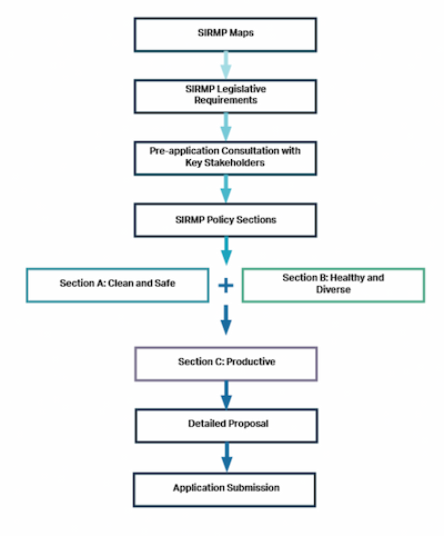
Plan Structure
The Policies
The SIRMP is designed to guide marine users, planners and regulators in the placement of existing and proposed activities, operations or developments. The type of activity or development proposed may have a significant bearing on the quality of the marine environment. The inclusion of policies and management measures will ensure sustainable development of the coastal and marine area and will help to address any potential adverse impacts.
The policies included in the SIRMP are the means of achieving the objectives and vision of the SIRMP, which is to provide clean and safe, healthy and biologically diverse, and productive marine waters around Shetland.
There are two key sections within this document when considering any proposed activity or development:
- Legislative Context and
- Policy Sections
All proposals for marine development and use which fall within devolved competencies must comply with legal requirements, should be in accordance with Scotland’s NMP and the policies in the first two policy sections of the SIRMP:
- Section A- Clean and Safe and
- Section B- Healthy and Diverse
Consideration should then be given to the cross-sector policies (MP DEV1, MP DEV2, MP DEV3 and MP FISH1) and the relevant sector-specific policies within:
- Section C- Productive
Figure 2 provides information on the steps to be implemented by applicants when considering a prospective marine development and/or use.
All the policies within the SIRMP are designed to conform with Scotland’s NMP. The policies laid out within the SIRMP apply to the inshore coastal area out to 12 nautical miles.
Legislative Context of Marine Development and/or Use
Proposals for marine developments and use may be required to take into consideration a number of legislative and regulatory procedures. This section provides information on principle legislation for the benefit of applicants submitting a proposal and interested parties. The information is not intended as an exhaustive list, and applicants will be required to have regard to all relevant legislative and regulatory requirements.
Applicants are strongly advised to consult with the relevant consenting authorities as early as possible in the development of any marine proposal. Appendix As provide additional information relating to key consultees.
Marine Licensing
With regard to the Scottish marine area it is a legal requirement under UK and Scottish law, as specified in Section 20 of the Marine (Scotland) Act 2010 and Section 65 of the Marine and Coastal Access Act 2009, to hold a marine licence to undertake various activities, including to do any of the following within the Scottish marine area:
- deposit any substance or object in the sea or on or under the seabed from a vehicle, vessel, aircraft, marine structure, a container floating in the sea, or a structure on land constructed or adapted wholly or mainly for that purpose;
- construct, alter or improve works in or over the sea or on or under the seabed;
- to use a vehicle, vessel, aircraft, marine structure or floating container to remove substances or objects from the seabed;
- carry out dredging;
- deposit or use explosives in the sea or on or under the seabed; and
- incinerate substances or objects on any vehicle, vessel, marine structure or floating container.
The above list is not exhaustive, and it is therefore recommended that prior to submitting a marine licence application, prospective applicants seek further information on what is licensable and how to apply for a marine licence from the Marine Directorate-Licensing Operations Team (MD-LOT). Exemptions from marine licensing exist for some activities.
Aquaculture developments may require a marine licence in respect of navigational safety.
Some activities are classified as reserved matters and as such are out with the scope of this plan. This plan and its policies only apply to matters within the devolved competence of the Scottish Ministers. Decisions to issue licences that impact reserved matters are made by the UK Government, not Scottish Ministers, and include defence, licensing the exploration and development of the UK’s offshore and onshore oil and gas resources, gas storage and unloading activities.
Key Contacts and Further Information
Works Licensing
Shetland Islands Council
Under Section 5 of the Zetland County Council Act 1974, as amended, (‘the 1974 Act’), the Shetland Islands Council has, among other duties, a duty to promote the conservancy of, and control of, development in the coastal area of Shetland,[7] with the exception of those areas under the jurisdiction of Lerwick Port Authority or Broonies Taing Pier Trust.
The Works Licence Policy[8] adopted by the Shetland Islands Council provides guidance to those considering proposals that fall within the scope of the 1974 Act. In general terms, this means the placing of ‘works’, as defined by the 1974 Act, in the sea, on the seabed or on the foreshore below Mean High Water Springs (MHWS) and extending out to 12 nautical miles. ‘Works’ means developments of all types excluding those for the purposes of marine fish farming. The ‘works’ that will require a works licence are primarily concerned with, but are not confined to, the following:
- Piers, marinas, breakwaters, sea defences and other constructions;
- Moorings, pontoons and moored barges;
- Pipelines and cables;
- Marine renewable energy developments (wave, tidal and wind);
- Dredging;
- Seaweed cultivation; and
- Septic tanks with sea outfalls.
It is recommended that any applicant considering a marine development or use, other than aquaculture, within the area of jurisdiction of the Shetland Islands Council consult the Council’s Coastal and Marine Planning Team to discuss the works licence process and obtain pre-application advice. A full copy of the Works Licence Policy, application forms and pre-application forms for a works licence can be obtained from Shetland Islands Council. Prospective applicants should consider the siting of the proposal using the SIRMP policies and maps in the subsequent sections.
As part of a works licence application the Shetland Islands Council consults with a range of local and national organisations and these are listed within Annex II of the Works Licence Policy and Appendix A.
Key Contacts and Further Information
Lerwick Port Authority
Proposals for development and use below MHWS within the Lerwick Harbour limits require a works licence application to be made to the Lerwick Port Authority (LPA). The LPA have General Directions for Navigation along with other policies and byelaws which should be considered by potential developers.[9] The LPA should be contacted for further information relating to development restrictions and opportunities within the Lerwick Harbour Area.
Key Contacts and Further Information
Planning Permission
Aquaculture
Planning permission is required for aquaculture developments (excluding seaweed cultivation), including amendments to existing sites and the development of any new sites. The local planning authority is responsible for the determination of planning applications for aquaculture developments, and it is advised that all potential applicants consult with the Coastal and Marine Planning Team of the Shetland Islands Council at the early stages of their proposal in order to obtain pre-application advice using the Council’s pre-application advice service.
Applications for aquaculture development will be considered in accordance with national and local planning guidance and the Shetland Islands Council’s Aquaculture Policy, adopted as Supplementary Guidance to the LDP. As part of a planning application, the Shetland Islands Council may consult with a range of local and national organisations, these are listed within Annex II of the Aquaculture Policy and Appendix A of this plan.
Aquaculture developments are granted certain Permitted Development (PD) rights under the Town and Country Planning (General Permitted Development) (Scotland) Order 1992 (as amended). This allows for a number of minor alterations to aquaculture developments without the need for additional planning permission, subject to the qualifications of the Order and any prior notification requirements, unless it involves a like-for-like replacement.
Land Based Elements
Proposals for marine development and use may require a land-based element (such as shore bases for aquaculture and seaweed development and land-based substations for marine renewable energy development). Land-based elements of marine proposals are subject to planning permission under the Town and Country Planning (Scotland) Act 1997, as amended by the Planning etc. (Scotland) Act 2006, unless permitted development rights apply. For land-based elements within the Lerwick Harbour Area, certain permitted development rights may apply.
Proposals for marine development and use must be in accordance with national planning and local guidance including, but not limited to, the historic environment, natural heritage, infrastructure services including water and waste water management, flood risk management, transportation, energy, and environmental impact assessment. It is advised that any proposal including a land-based element consult with the Shetland Islands Council’s Development Management Service as early as possible to seek pre-application advice
Key Contacts
- Shetland Islands Council – Coastal & Marine Planning Team (marine development/aquaculture)
- Shetland Islands Council – Development Management Team (land-based development aspects)
Further Information
- Scottish Government – Marine and Fisheries
- Scottish Government – Fish Farming Permitted Development Rights Guidance
- Scottish Government – National Planning Framework 4
- Permitted Development Rights Order
Controlled Activities Regulations (CAR) Authorisation
The Water Environment and Water Services (Scotland) Act 2003 (WEWS Act) gives Scottish Ministers powers to introduce regulatory controls over water activities in order to protect, improve and promote sustainable use of Scotland’s water environment. This includes wetlands, rivers, lochs, transitional waters (estuaries), coastal waters and groundwater.[10]
In accordance with the Water Environment (Controlled Activities) (Scotland) Regulations 2011 (CAR), an authorisation is required for activities in the marine environment (out to 3 nautical miles) including, but not limited to, those activities involving discharges of pollutants and water abstraction.[11] Applications for new fish farm developments, discharges to the sea from septic tanks, etc. are examples of activities that may require a CAR authorisation.
It is strongly advised that where proposals may have an impact on the water environment, applicants should seek further information relating to CAR from the regulator, the Scottish Environment Protection Agency (SEPA).
Key Contacts and Further Information
Section 36 Consent - Electricity Act 1989
Any offshore electricity generation scheme with a permitted capacity greater than 1 megawatt (MW) must apply for and obtain the consent of Scottish Ministers under s36 of the Electricity Act 1989.[12] Such consent must be obtained before an electricity generating station with a capacity greater than 1MW can be constructed or operated in the Scottish marine area. Similar to marine licences, s.36 consents can be granted with conditions.
Offshore generating stations (0-12nm) with a capacity of 1MW or less do not require consent under s36.
All offshore generating stations, regardless of capacity, will also require a marine licence from the Marine Directorate-Licensing Operations Team (MD-LOT). Special licensing procedures allow MD-LOT to consider applications for consents and licences under both the Electricity and the Marine Acts together, when appropriate.
The Growth and Infrastructure Act 2013 amends the Town and Country Planning (Scotland) Act 1997 to allow Scottish Ministers, when granting consent under Section 36 of the Electricity Act 1989, to direct that planning permission is deemed granted for any onshore development ancillary to the operation or change of use related to the consent.[13] For developments not requiring s.36 consent, planning permission from Shetland Islands Council will still be required for relevant onshore ancillary equipment.
A works licence will be required from the Shetland Islands Council for all offshore electricity generation developments and associated works within its jurisdiction, regardless of capacity.
Key Contacts and Further Information
- Marine Directorate – Licensing Operations Team (MD-LOT)
- Shetland Islands Council – Coastal & Marine Planning Team (marine development & works licences)
- Shetland Islands Council – Development Management Team (land-based development)
Seabed Lease- Crown Estate Scotland
Crown Estate Scotland (CES) manages the entire seabed out to 12 nautical miles (territorial sea limit). CES is therefore responsible for issuing seabed leases for activities such as aggregates, aquaculture, marine renewables, and cables and pipelines. In addition, the CES is responsible for marinas and moorings, and has an interest in parts of many ports and harbours.
It is likely that for the majority of marine developments and activities, a seabed lease will be required. Therefore, it is recommended that prospective applicants undertake early consultation with CES at the same time as progressing discussions with the relevant consenting bodies. The Scottish Crown Estate Act 2019 allows for different types of organisations to become asset managers,[14] CES can advise if this change affects any areas within the Shetland Marine Region.
Key Contacts
Environmental Impact Assessment (EIA)
The potential impact of various types of proposed development and use can be assessed by undertaking specific detailed impact assessments in order to assess their full implications. The most widely recognised assessment is the Environmental Impact Assessment (EIA), which identifies the environmental effects of development proposals.
Not all development and use will require a formal EIA, and proposals will be assessed against legislative criteria. Development and use falling within Schedule 1 of the relevant EIA regulations e.g., the Town and Country Planning (Environmental Impact Assessment) (Scotland) Regulations 2017, Marine Works (Environmental Impact Assessment) (Scotland) Regulations 2017, or the Electricity Works (Environment Impact Assessment) (Scotland) Regulations 2017, will require an EIA. For development and use that falls within Schedule 2 of those regulations, an initial ‘screening’ stage is undertaken to determine whether an EIA is required. Development and use falling within Schedule 2 include intensive fish farming and renewable energy.
Key Contacts and Further Information
Habitats Regulations Appraisal
Special Protection Areas (SPAs) and Special Areas of Conservation (SACs) (commonly known as European sites), and European Protected Species are designated and protected under the Conservation (Natural Habitats, &c.) Regulations 1994 (as amended in Scotland), often referred to as the ‘Habitats Regulations’.
The Habitats Regulations require competent authorities to carry out a Habitats Regulations Appraisal (HRA) of any plan or project that might affect a European site.[15] This involves screening the plan or project in order to determine whether the plan or project, either alone or in-combination with other plans or projects, is likely to have a significant effect on the site (i.e. whether it could affect any of the habitats or species for which the site is designated). If it is established that the plan or project is likely to have a significant effect and it is not directly connected with or necessary to the management of the site, the competent authority will carry out an Appropriate Assessment (AA) of the implications of the site in view of the site’s conservation objectives. A plan or project will not be authorised unless it can be shown, beyond reasonable scientific doubt through an AA, that the plan or project will not adversely affect the integrity of a European site or that, notwithstanding a negative result, there are no alternative solutions and that the plan or project must be carried out for imperative reasons of overriding public interest.
It should be noted, that at the time of publication, the Natural Environment (Scotland) Bill 2025 is being considered within Scottish Parliament. The Bill will provide Ministers with the power to amend the Habitats Regulations and EIA legislation outside of the EU framework.
Key Contacts and Further Information
Cumulative Impacts
When considering the potential benefits and adverse effects of proposed development and use, decision-makers should take into account any multiple and cumulative impacts of proposals, in the light of other projects and activities.
In accordance with the UK Marine Policy Statement, consenting authorities will need to consider the potential cumulative impacts of activities such as whether:
- The cumulative impact of activities, either by themselves over time or in conjunction with others, outweighs the benefits;
- A series of low-impact activities would have a significant cumulative impact which outweighs the benefit;
- An activity may preclude the use of the same area/resource for another potentially beneficial activity.
In addition, the EIA regulations require the assessment of ‘likely significant effects’ of proposed projects in the environment which have been identified as “direct effects and any indirect, secondary, cumulative, short, medium and long-term, permanent and temporary, positive and negative effects of the project”.[16]
If a Habitats Regulations Appraisal is required under the Conservation (Natural Habitats, &c.) Regulations 1994,[17] in-combination effects are assessed as part of the screening stage of the assessment.
Land-Sea Interface
The SIRMP area extends up to the mean high water spring (MHWS) level, whilst the terrestrial planning boundary extends to mean low water springs (MLWS), creating physical overlap over the coastal zone. This overlap ensures that marine and land planning will address the whole of the marine and terrestrial environments respectively.
Integration of marine and terrestrial planning will be achieved through consistency between marine and terrestrial policy documents and guidance.
Any proposed marine development or activity with a land-based element must have regard to the impacts on the terrestrial environment, its infrastructure, and local community, as well as the implications on the marine environment. Applicants should also have regard to the policies as set out in the SIC LDP, the NPF4 and any other relevant national planning guidance.
Similarly, all public authorities taking authorisation or enforcement decisions must do so in accordance with the appropriate marine plans, unless relevant considerations indicate otherwise. Moreover, public authorities must have regard to the appropriate marine plans when making any decision which relate to a function, the exercise of which, is capable of affecting whole or part of the Scottish marine area, but which is not an authorisation or enforcement decision.
Consultation
Pre-application Consultation with Communities
Statutory pre-application requirements are set out in the Marine Licensing (Pre-Application Consultation) (Scotland) Regulations 2013. The 2013 Regulations require prospective applicants for certain licensable activities to notify relevant stakeholders that an application for a marine licence is to be submitted. Pre-application consultation with relevant stakeholders, including local communities, and early discussions with the relevant consenting authority can enhance the proposal's quality, mitigate negative impacts, clarify misunderstandings, and address community concerns within the early stages of the consulting process.
For pre-application information and requirements relating to marine licensing visit Marine licensing: considerations before submitting an application.
For development that falls within the planning acts, statutory pre-application consultation with communities is required only for major and national developments. For fish farming, this applies to developments where the surface area of water covered is or exceeds 2 hectares.
However, the Shetland Islands Council Marine and Coastal Planning Team recommend developers use the Council’s pre-application service before submitting development proposals and, where applicable, recommend that applicants consider contacting communities at an early stage to raise awareness and seek engagement on their proposals.
Key Contacts and Further Information