Shetland Islands Regional Marine Plan
This plan covers the management of the Scottish Marine Region for the Shetland Isles. It guides and supports decision making for development and use of the sea, and represents the second tier of marine planning following on from the National plan.
Section A- Clean & Safe
Water Resources
Shetland’s water resource underpins the productivity of many of its key industries. It supports healthy and biologically diverse seas which are important for a number of ecosystem goods and services ranging from climate regulation to marine recreation and fisheries. An overview of the current status of Shetland’s marine environment in relation to water quality is given in the Shetland Islands Marine Region State of the Environment Assessment.
River Basin Management Planning
Scotland’s water environment is regulated through the Water Environment (Controlled Activities) (Scotland) Regulations 2011, more commonly known as the ‘Controlled Activity Regulations (CAR)’, and their amendments. This legislation arose from the transposition of the Water Framework Directive by the Water Environment and Water Services (Scotland) Act (WEWS) 2003. WEWS introduced River Basin Management Planning based on ‘River Basin Districts’ and ‘International River Basin Districts’ for Scotland’s water environment.
River Basin Management Plans (RBMPs) are produced by SEPA on behalf of the Scottish Government. RBMPs cover actions for public bodies, industry and land managers in Scotland. River basin planning aims to protect and improve Scotland’s water environment and focuses on reducing resource use, eliminating waste and restoration of natural capital. WEWS affects various areas such as conservation, fisheries, flood defence, planning, and environmental monitoring.
Under WEWS, SEPA maintain the implementation of environmental standards for the water environment, including the assessment of the ecological status of water bodies. Within the 2023 State of Scotland’s Water Environment Report published by SEPA, the overall condition of Shetland’s surface and groundwater was classified as having ‘Good’ environmental status. This includes rivers, lakes, estuaries, groundwater, and coastal waters up to 3 nautical miles. Future plans will focus on improving and maintaining water quality, whilst balancing social and economic benefits.
Further information on River Basin Management Planning including classification is available on SEPAs website: River basin management planning | Scottish Environment Protection Agency (SEPA).
Marine Strategy
The UK Marine Strategy aims to achieve ‘Good Environmental Status’ (GES) of the UK marine environment. Achieving and maintaining GES involves protecting the marine environment, prevention of deterioration, restoration where practicable and sustainable use of marine resources.[18]
The SIRMP will contribute to meeting these objectives, particularly in relation to spatial measures. The policies in the SIRMP consider how activities can shape the marine area to support the goals of the above strategies and legislation, as well as those of other relevant legislation.
Policy MP WAT1: Water Ecology
Proposals for marine development and use should consider the likely effects, including cumulative effects, on water quality and the benthic environment.
Proposals should not cause any waterbody to deteriorate in quality or ecological status*, nor prevent the achievement of established objectives set out in the Scotland River Basin Management Plan.
Where there is a significant risk that relevant objectives** will not be achieved, applicants may be required to identify how the proposal will contribute to achieving relevant objectives to improve the chemical and ecological status of coastal water bodies.
* Aquatic Classification | Scottish Environment Protection Agency (SEPA)
**Objectives are detailed in the relevant ‘River Basin Management Plan’ for Scotland and available to view via the Water Environment Hub (sepa.org.uk)
Justification and Considerations
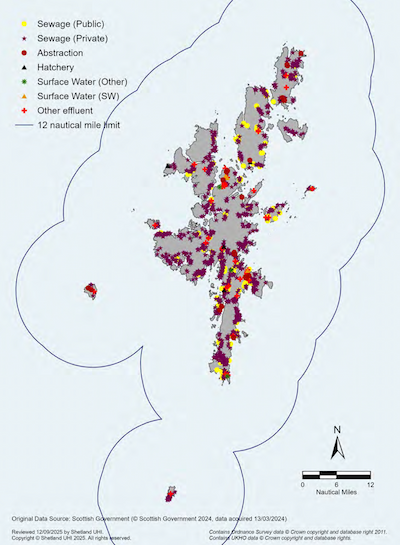
Existing discharge locations are shown in Map 1, Shellfish Protected Areas are shown in Map 2.
Coastal and marine development and use can have adverse effects on transitional waters, coastal waters and marine waters. During all phases of the development or use there may be increased demand for water, discharges to water, and adverse ecological effects resulting from physical modifications to the water environment.
Additionally, the potential impacts on ecological water quality from an increased risk of spills and leaks of pollutants, as well as the higher likelihood of invasive non-native species transmission, should be considered.
Development and use can also contribute to the improvement of water quality and ecology.
SEPA and other regulators may require marine development or use to take action to enhance the water environment where there is a significant risk of failing to meet environmental objectives due to the current condition of the water environment.
Key Consultees
- SEPA
Further Information
- UHI Shetland – Shetland Marine Region State of the Environment Assessment
- SEPA – River Basin Management Planning
- Marine Strategy Part One: UK updated assessment and Good Environmental Status
- Water Environment (Shellfish Water Protected Areas: Designation) (Scotland) Order 2016
- SEPA – Water Environment Hub
- Implementing the Water Environment and Water Services (Scotland) Act 2003
- Shetland Islands Council – Local Development Plan (SIC LDP)

Invasive Non-native Species (INNS)
A non-native species (introduced, alien species, exotic species, or non-indigenous species), is a species living outside its native distributional range, which has arrived there by human activity, either deliberate or accidental. Invasive non-native species (INNS) are those species which may have an adverse impact on native biological diversity and/or a range of other activities. The effects of non-native species can include, but are not limited to, predation of or competition with native species, habitat alteration, changes in water quality and the transmission of disease or parasites. The spread and impact of non-native species may be exacerbated by climate change.
The Shetland Islands Marine Region State of the Environment Assessment highlights the increasing number of non-native species found in the Shetland Islands Marine Region. Locally, the Biosecurity Plan for the Shetland Islands sets out a management strategy to address the introduction and spread of INNS, and identifies marine non-native species currently present or at risk of introduction. Marine activities may also pose the risk of introducing predatory mammals to islands with important seabird colonies.
Policy MP INNS1: Reducing the Spread of Invasive Non-Native Species (INNS)
Proposals for marine development and use should consider the potential risks of introducing or spreading INNS, having regard to the Scottish Government’s Non-native Species: Code of Practice.
Where there is a risk of proposals establishing new pathways for the spread of INNS, applicants should identify relevant measures to reduce these risks. The assessment and identification of these risks and relevant measures could be set out in a biosecurity plan.
Particular risks may occur when moving equipment, boats or aquatic animals (e.g., fish and shellfish), introducing structures suitable for settlement of aquatic INNS or which facilitate the movement of terrestrial INNS, including to islands.
Proposals in areas where INNS are known to exist should seek to minimise the risk of further spread or reintroduction.
Applicants should refer to the associated SIRMP Supporting Guidance on Marine Biosecurity.
Justification and Considerations
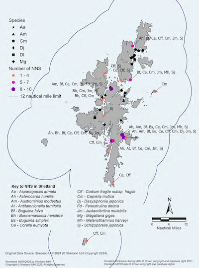
Marine biosecurity planning is a critical step in creating a framework to reduce the risks of introducing or spreading INNS. Applicants should refer to relevant guidance on marine biosecurity, including the SIRMP Supporting Guidance on Marine Biosecurity and the Biosecurity Plan for the Shetland Islands which highlights sector-specific measures. Applicants may be required to provide supporting information to allow assessment of potential impacts. High-risk entry points and the distribution of target marine non-native species in Shetland are shown in Map 3.
INNS have the potential to pose significant threats to marine biodiversity and cause economic impacts to marine industries. In Scotland, the Wildlife and Countryside Act 1981 (as amended) is the principal legislation dealing with non-native species. The 1981 Act includes a number of offences relating to the release or spread of non-native species. The Scottish Government Non-native Species: Code of Practice sets out responsibilities to prevent the introduction of non-native species.
INNS management is guided by a hierarchical approach of prevention, rapid response, and control and containment. It is extremely hard to remove an invasive species once it is established. To prevent the introduction of non-native species, the risks associated with proposed marine development and activities that may facilitate the spread of non-native species should be carefully evaluated. A precautionary approach should be adopted, with biosecurity measures implemented as needed and guided by best practice.
Regular monitoring is an important component of early detection and rapid response. Detections of novel non-native species should be reported as soon as possible to allow early control actions to be taken if needed. Marine invasive species sightings can be reported to the Scottish Government at MarineNonNativeSpecies@gov.scot and locally to marineplan.shetland@uhi.ac.uk, or submitted via iRecord.
Raising awareness of the potential for the introduction and spread of INNS is of paramount importance to improving biosecurity across Shetland and preventing impacts to marine-dependent industries in Shetland, such as tourism, aquaculture and fisheries.
Key Consultees
- NatureScot - lead body for INNS in Scotland
- UHI Shetland - maintain a database of records of marine INNS in Shetland
- Shetland Biological Records Centre - maintain a database of local records of terrestrial INNS
Further Information
- SIRMP Supporting Guidance on Marine Biosecurity
- Shetland Marine Region State of the Environment Assessment
- UHI Shetland – Biosecurity Plan for the Shetland Islands
- UHI Shetland – INNS research and monitoring
- Scottish Government – Scotland’s National Marine Plan
- Scottish Government – Invasive non-native species
- Scottish Government Non-native Species: Code of Practice
- NatureScot – Marine non-native species information
- NatureScot – Marine Biosecurity Planning Guidance
- Defra – Biosecurity Hub
- SEPA – Invasive non-native species
- GB Non-Native Species Secretariat
- Great Britain Invasive Non-native Species Strategy 2023-2030
- RYA and British Marine – The Green Blue
- Biosecurity for LIFE – Preventing spread of invasive predators
- Regional Inshore Fisheries Group
Invasive non-native species
A Biosecurity Plan for the Shetland Islands forms part of Shetland’s overall approach to marine planning and management to ensure INNS do not adversely alter the ecosystem, nor impact marine industries. The Biosecurity Plan includes a range of measures such as raising awareness and education about INNS and providing advice on appropriate surveillance methods.
Systematic research and monitoring have been carried out in Shetland since 2012 to inform management and policy in this area. The reporting of any sightings of non-native species to UHI Shetland and Shetland Biological Records Centre is encouraged and advocated, to ensure an appropriate response can be implemented and preventative measures put in place to address any potential problems in the future.
All marine users can ensure the potential spread of INNS is reduced by assessing risks posed by activities and following Check, Clean, Dry principles. These include:
- a) Checking and maintaining that boat hulls are clear of fouling organisms, particularly when moving to and from new areas;
- b) Cleaning boats and equipment before transporting them from one water body to another;
- c) Cleaning and drying dive and fishing gear after use.
Marinas and ports are encouraged to promote awareness of INNS amongst their users. Please note that artificial structures have the potential to become platforms for the settlement of INNS and therefore can act as a ‘stepping stone’ for the spread of INNS.
Examples of INNS with the potential to cause adverse effects currently absent in Shetland waters:
- Didemnum vexillum (carpet sea squirt/marine vomit)
- Styela clava (leathery sea squirt)
- Undaria pinnatifida (Wakame – Japanese kelp)
- Sargassum muticum (wireweed)
- Crepidula fornicata (slipper limpet)
Waste Minimisation
The environmental and social impact of marine litter is highlighted within the Shetland Islands Marine Region State of the Environment Assessment and is also of increasing public concern. The Scottish Government published a Marine Litter Strategy outlining its objectives to reduce the amount of litter entering the marine environment from both land and sea-based sources. In alignment with these commitments, the SIRMP seeks to encourage marine users and developers to dispose of litter in ways that do not harm the marine environment.
Policy MP WST1: Waste Minimisation
Proposals for marine development and use should consider measures to safely dispose of waste material and debris associated with the relevant construction, operational and decommissioning stages. The production of waste should be minimised as far as possible through consideration of the waste hierarchy (reduce, reuse or recycle) and disposal of any waste must only be through the use of appropriate licensed facilities.
Applicants may be required to provide a waste minimisation and management plan documenting a strategy proportionate to the scale and nature of the proposal. Applicants should refer to the associated SIRMP Supporting Guidance on Waste Minimisation and Management Plans.
Justification and Considerations
Marine litter is a global environmental issue posing a threat to ecosystems through direct and indirect environmental, social and economic impacts. Marine litter can result in the deaths of countless seabirds and marine mammals globally each year from becoming entangled in or ingesting marine litter.[19] Marine litter can damage coastal habitats, interfere with biological production and damage or smother the seabed. It can also have significant effects on the scenic quality of the coastline, eroding and diminishing the otherwise typically highly scenic coastal landscape.
Social and economic impacts associated with marine litter can affect many sectors. Local authorities incur costs annually from the removal and disposal of beach litter and the Scottish fishing fleet is impacted through dumped catch, repairs to gear and lost fishing time.
The Shetland Islands Marine Planning Partnership has produced Supporting Guidance on Waste Minimisation and Management Plans to assist applicants in producing waste minimisation and management plans. The guidance sets out when a plan may be required and the level of detail that should be provided.
Where there is a land-based component associated with a marine development or use, developers should consider all relevant terrestrial planning guidance and legislation associated with waste management including Scotland’s NPF4 and the SIC LDP.
Key Consultees
- Shetland Islands Council – has statutory powers to issue notices for littering and dumping on public ground.
- SEPA – responsible for registering waste carriers and controlling fly-tipping.
- Marine Directorate – Licensing Operations Team – statutory duty to control deposits of objects and substances in sea/tidal areas e.g., deposit of dredged material as well as having consenting powers for marine licences.
- Maritime and Coastguard Agency (MCA) – control and manage pollution at sea i.e. from vessels.
Further Information
- UHI Shetland – Shetland Marine Region State of the Environment Assessment
- SIRMP Supporting Guidance on Waste Minimisation and Management Plans
- Scottish Government – Scotland’s National Marine Plan
- Scottish Government – National Planning Framework 4
- Scottish Government – Marine Litter Strategy for Scotland
- Scottish Government – Code of Practice on Litter and Refuse (Scotland) 2018
- Shetland Islands Council – Local Development Plan
- OSPAR Commission – Marine Litter
- SEPA - Waste Guidance
- Shetland Amenity Trust – Da Voar Redd Up
- KIMO – Plastic Pollution and Marine Litter
- Fishing For Litter
- Scottish Islands Federation – Marine Litter Working Group
- Ghost Fishing UK
- Marine Conservation Society – Great British Beach Clean
Marine Litter Initiatives
In Shetland, there are a number of initiatives and projects involving the community and local industry working to collect and monitor litter including Da Voar Redd Up, Fishing for Litter, Ghost Fishing UK, Marine Conservation Society’s Great British Beach Clean and Scottish Islands Federation Marine Litter Working Group.
The main types of litter identified during beach surveys are plastics, textiles (including nets/ropes) and plastic bottles. The main source of litter collected at the coast is from the sea and mainly derived from marine industries, both locally generated and from more distant sources including Canada, the USA, Mexico, Denmark and Russia. Other sources of coastal litter include agricultural and domestic waste.
Surface and Underwater Noise and Vibration
Noise and vibration can result from marine development and use, ranging from shipping to acoustic deterrents. The noise can be continuous or temporary, and can occur at different stages of a development process. Noise and vibration from marine development and use can occur above water, underwater or both. Within the Shetland Islands Marine Region, the current levels of underwater noise, and therefore their impacts, are not known.
Policy MP NOISE1: Minimising Levels of Surface and Underwater Noise and Vibration
Proposals for marine development and use should consider the effects of man-made surface and underwater noise and vibration on the marine environment, species, and people, including the potential cumulative effects. Proposals should avoid significant adverse effects of man-made noise and vibration, especially on species sensitive to such effects.
Where significant adverse impacts are identified, applicants may be required to:
- a) submit a surface and underwater noise and vibration impact assessment or supporting information to describe the duration, type and level of noise and vibration expected to be generated at all relevant stages of the development (construction, operation, decommissioning); and
- b) identify mitigation measures to minimise the adverse impacts associated with the duration and level of noise and vibration activity.
Where this includes a European Protected Species (EPS), note that an EPS Licence may be required. Consideration of impacts on Priority Marine Features (PMFs) may also be required.
Justification and Considerations
As recognised in the UK Marine Policy Statement, “noise resulting from a proposed activity or development in the marine area, coastal and estuarine waters can have adverse effects on biodiversity”.[20] However, knowledge is limited on the actual extent of impacts. Anthropogenic noise emitted within the marine environment has the potential to mask biologically relevant signals, can lead to a variety of behavioural reactions, affect hearing organs, and injure or even kill marine life. Particular sources of concern are marine-related noise as a result of: explosions; shipping; seismic surveys; offshore construction and offshore industrial activities (i.e. dredging, drilling and piling); sonar of various types; and acoustic deterrent devices.
Marine noise can have a negative effect on human beings. For example, excessive noise can impact on the quality of human life, health, and use and enjoyment of areas, including those with high visual quality.[21]
The potential impact on all marine receptors therefore needs to be considered and managed appropriately. It is advised that applicants consult with the local planning authority, the Marine Directorate-Licensing Operations Team, and NatureScot in relation to potential noise impacts as early as possible in the design and development of any marine-related project.
Noise and vibration impact assessments or supporting information may include details on the type, level and duration of noise expected to be generated throughout all stages of the development or activity.
Examples of noise mitigation measures include locating noise-generating devices away from sensitive receptors where feasible. Monitoring techniques to detect the presence of marine mammals include the use of marine mammal observers (MMOs) and passive acoustic monitoring (PAM).
Key Consultees
- NatureScot
- Marine Directorate – Licensing Operations Team
Further information
- OSPAR Commission – Underwater Noise
- Scottish Government – Scotland’s National Marine Plan
- NatureScot Commissioned Report 517 – Establishing the sensitivity of cetaceans and seals to acoustic deterrent devices in Scotland
- NatureScot Research Report 1070 – A review of noise abatement systems for offshore wind farm construction noise, and the potential for their application in Scottish waters
- JNCC – Guidelines for minimising the risk of injury to marine mammals from geophysical surveys (seismic survey guidelines)
- JNCC – Statutory nature conservation agency protocol for minimising the risk of injury to marine mammals from piling noise
- JNCC – Guidelines for minimising the risk of disturbance and injury to marine mammals whilst using explosives
- COWRIE (Collaborative Offshore Wind Research into the Environment)
- Southall et al. (2019). Marine mammal noise exposure criteria: Updated scientific recommendations for residual hearing effects. Aquatic Mammals 45(2), 125-232.
- NOAA Fisheries – Technical Guidance for Assessing the Effects of Anthropogenic Sound on Marine Mammal Hearing
- Good Practice Guide for Underwater Noise Measurement (2014)
Safeguarding Ports and Navigation Safety
Maritime safety is of key importance, underpinned by international conventions and guidelines issued by the International Maritime Organisation to ensure safe, secure and efficient shipping on clean oceans. Under the UN Convention on the Law of the Sea (UNCLOS) vessels have the right of innocent passage and freedom of navigation.
One of the objectives of the SIRMP is to provide a safe marine environment for all users and activities. The SIRMP policies help ensure that the conditions necessary for the efficient and safe movement of shipping to and from ports and harbours are maintained. It is also important to create conditions for safe shipping traffic around the Shetland coast in association with the relevant consenting authorities and maritime agencies. The subsequent shipping policies and mapping will contribute toward safe shipping and navigation around the Shetland coast.
Policy MP PORT1: Harbour Plans
Proposals for marine development and use within a designated harbour area should consider any harbour plans, policies, directions and byelaws in place within such designated harbour areas.
Policy MP SHIP1: Safeguarding Navigation Channels and Port Areas
Proposals for marine development and use should consider safety and navigation impacts on other marine users.
Applicants may be required to demonstrate the proposal will not have an adverse impact on the efficient and safe movement or navigation of shipping to and from ports, harbours, marinas and anchorages or the long-term operational capacity of a ferry operation. Where shipping may be displaced, applicants may be required to quantify and consider the impacts of increased fuel use.
Proposals which have the potential to restrict identified future expansion of important ports and harbours (e.g., as identified within a local development plan or masterplan) may be refused.
Justification and Considerations
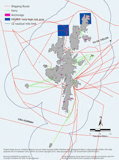
Harbour areas and anchorages are shown in Map 4. The identification and location of main shipping routes are shown in Map 5. It is not possible to map all small vessel movements within the Shetland Islands Marine Region, but small ferry and yacht routes are shown.
Shetland’s harbour areas are essential hubs for many of Shetland’s marine activities including aquaculture, fisheries, tourism, recreation, oil and gas, and transportation. It is essential that port activity is maintained and that safe navigation to these areas is not restricted. It should be noted that any marine development or use within the Lerwick Harbour Area will require a works licence from the Lerwick Port Authority.
Decision-makers should carefully evaluate and balance shipping interests with other marine activities around the Shetland coast and require that the provisions for safe shipping traffic are safeguarded as a condition of any development consent.
Navigation channels are not a given size but are scaled relative to the distance between two land masses. For this reason, it is difficult to put a standard safety zone around shipping routes without wasting an area for another use that could safely occur. It should also be noted that ferry terminals and port areas require a certain amount of operational area for vessels approaching and leaving a pier, in addition to a navigation space for onward shipping routes.
Shipping over 5000 tonnes is regulated by international agreements and such vessels are generally inflexible in terms of where they can go. In Shetland, this would include: cruise liners, large shipping and ferry vessels, cargo vessels, oil-related vessels such as diving support ships, platform supply vessels and oil tankers.
In some areas of Shetland, shipping not regulated by international agreements has greater potential to be flexible with respect to other uses. The types of vessels Shetland receive in this category include: small fishing vessels, small ferries, aquaculture work boats, yachts and hobby boats.
Developers are advised to enter into pre-application discussions with the relevant authorities e.g., Lerwick Port Authority or Shetland Islands Council Ports and Harbour Operations, and the Northern Lighthouse Board.
Policy MP SHIP2: Marine Environmental High-Risk Areas (MEHRAs)
Proposals for marine development and use should consider the presence and status of Marine Environmental High Risk Areas (MEHRAs).
Justification and Considerations
Shipping is under significant pressure to minimise the impact of accidents and operations on the marine environment. Oil spills, collisions and groundings, as well as waste discharges, anti-fouling systems, anchor damage, wake impacts and ship-generated noise, have become increasingly important and high-profile issues.
Ship owners and operators can take action by ensuring the integrity, maintenance and effective environmental management of their vessels, and through due consideration of the environmental requirements of any regions in which their ships will operate. In order to achieve the latter, Marine Environmental High Risk Areas (MEHRAs) have been identified. MEHRAs are areas of high environmental sensitivity which are also at risk from shipping. MEHRAs are shown on Admiralty Charts as an area to be avoided as an encouragement to mariners to take extra care in these areas. Routing measures aim to encourage ships to follow routes where vessels are less likely to collide with each other, run ashore or get into difficulties. They also aim to reduce the scope of a disaster if a ship does get into difficulty, directing ships away from environmentally sensitive areas where pollution would be highly damaging.
Key Consultees
- Marine Directorate – Licensing Operations Team
- Northern Lighthouse Board
- Shetland Islands Council – Ports and Harbours Operations
- Lerwick Port Authority
Further Information
- Maritime and Coastguard Agency
- Scottish Government – Scotland’s National Marine Plan
- Lerwick Port Authority – Health, Safety, Environment and Quality
- Lerwick Port Authority – General Directions for Navigation and Byelaws
- Marine Environmental High Risk Areas (MEHRAs)
- International Maritime Organization (IMO)
- Department for Transport – Port Marine Safety Code
- Scalloway Harbour Oil Spill Contingency Plan
- Sullom Voe Harbour Oil Spill Contingency Plan

Utility Cables and Pipelines
Utility cables (e.g., telecommunications, electricity) and pipelines (e.g., oil and gas, water, aquaculture) are buried deep in the seabed where possible. Where burial is not feasible, they tend to be placed on top of the seabed and protected by rock armour or concrete mattresses. Installers and operators are required to promote marine safety and protection by raising awareness among other marine users of the location of this infrastructure.
Policy MP ACBP1: Avoidance of Cables and Pipelines
Proposals for marine development and use must comply with statutory safety zones around oil and gas platforms, well heads and associated pipelines.
Additionally, where development is within a 250m zone either side of utility cables (telecommunications, electricity or water supply) or pipelines, developers should be aware of the possible requirement for proximity agreements.
Justification and Considerations
The purpose of this policy is to protect cables and pipelines and address potentially serious public safety issues. The identification of major cables and pipelines, outlined in Map 6 is a step in meeting this aim.
The Petroleum Act 1987 establishes safety zones around oil and gas platforms, well heads and associated pipelines. In the past, some dredging and trawling activities have caused damage to communication and electricity cables. These cables provide lifeline services to Shetland and damage can jeopardise this, as well as requiring extra resources for repair. As pressure on marine resources, exploration and installation activity increases around Shetland waters, it is imperative that marine users are made aware of this infrastructure and avoid it in order to reduce disruption. Pre-application consultation with the owners of pipelines and utility cables is therefore strongly advised. Additionally, developers should also contact Crown Estate Scotland at an early stage in their proposals to seek advice on the need for proximity agreements.
Additionally, within a 250m zone either side of utility cables (telecommunications, electricity or water supply) or pipelines, a proximity agreement with the asset owner may be required by Crown Estate Scotland in order to obtain a seabed lease.
Developers are advised to use Shetland Island’s Council’s pre-application service and to enter into early discussions with Crown Estate Scotland, utility cable owners/operators or pipeline owners/operators where proposals are in close proximity of cables or pipelines.
Key Consultees
- Marine Directorate – Licensing Operations Team
- Shetland Islands Council
- Scottish Water
- SSE
- SEPA
Further Information
- European Subsea Cables Association
- KIS-ORCA Information Service Cable Awareness
- International Cable Protection Committee (ICPC)
- Scottish Government – Scotland’s National Marine Plan
- Shetland Islands Council – Marine and Coastal Planning Pre-application advice

Climate Change
The SIRMP is based on an ecosystem approach, ensuring the use of the marine environment is spatially planned where appropriate. Details of actual and potential effects of climate change on the marine and coastal environment within Shetland are detailed within the Shetland Islands Marine Region State of the Environment Assessment.
All new and modified development or use will be expected to have regard to climate change projections, and include provision for the mitigation of and adaptation to climate change.
Policy MP CLIM1: Climate Change Mitigation
Proposals for marine development and use should consider climate change mitigation.
Applicants may be required to provide supporting information on how the following has been assessed and minimised:
- a) resource use;
- b) energy use; and
- c) greenhouse gas emissions.
Applicants should refer to the associated SIRMP Supporting Guidance on Climate Change Mitigation and Adaptation.
Applicants should consider adverse impacts on habitats which act as a carbon sink, or which protect against coastal erosion, and how these may be mitigated.
The Shetland Islands Marine Planning Partnership has produced Supporting Guidance on Climate Change Mitigation and Adaptation for applicants on providing supporting information on climate change mitigation and adaptation to support policies MP CLIM 1 and MP CLIM2. The guidance sets out when supporting information will be required alongside examples of how it can be provided.
Examples of low resource use include the use of energy-efficient construction; use of renewable energy sources; reduced need for travel/transportation; and waste management.
For a list of habitats which act as a carbon sink, please refer to the NatureScot Commissioned Report 957: Assessment of Blue Carbon Resources in Scotland's Inshore Marine Protected Area.
Policy MP CLIM2: Climate Change Adaptation
Proposals for marine development and use should consider the current and future risks of climate change on siting, design, and operation over the lifetime of the development and how these can be minimised.
Applicants may be required to provide supporting information demonstrating that risks have been considered and minimised and should refer to the associated SIRMP Supporting Guidance on Climate Change Mitigation and Adaptation.
Justification and Considerations
Understanding the impacts and effects of climate change is key to maintaining a safe marine environment. The UK Climate Change Risk Assessment and Marine Climate Change Impacts Partnership provide scientific evidence of impacts and projections. Sea level rise, increased land and sea temperatures, extreme weather events such as storm surges and increased flooding and coastal erosion, will lead to increased vulnerability for development and significant change along parts of the Shetland coast. Adaptation is necessary to address these current and future climate change impacts enabling ecosystems and communities be more resilient.
In determining applications for marine development and use, consenting authorities, where relevant, will consider the likely impact of the proposal on climate change, including any management and/or mitigation measures proposed by the applicant. Applicants may be asked to consider impacts on habitats which act as a carbon sink.
Key Consultees
Climate change mitigation and adaptation is not the responsibility of any one agency. It is recommended that any climate change mitigation and adaptation strategies incorporated into a proposal are included in consultation conversations with all consultees.
Further Information
- SIRMP Supporting Guidance on Climate Change Mitigation and Adaptation
- UHI Shetland – Shetland Islands Marine Region State of the Environment Assessment
- Shetland Islands Council – Local Development Plan
- Scottish Blue Carbon Forum
- Scottish Government National Planning Framework 4
- Scottish Government – Scotland’s National Marine Plan
- Scottish Government – Re-Evaluating Scotland's Sedimentary Carbon Stocks
- Scottish Government – A Compendium of Marine Related Carbon Stores, Sequestrations and Emissions
- Scottish Government – Carbon budgets and potential blue carbon stores
- Scottish Government – Adaptation to climate change
- UK Climate Change Projections
- UK Climate Change Risk Assessment (CCRA)
- Dynamic Coast: Scotland’s Coastal Change Assessment
- Marine Climate Change Impacts Partnership
- NatureScot Research Report 1326 – Scottish Blue Carbon – a literature review of the current evidence for Scotland’s blue carbon habitats
- Adaptation Scotland