Shetland Islands Regional Marine Plan
This plan covers the management of the Scottish Marine Region for the Shetland Isles. It guides and supports decision making for development and use of the sea, and represents the second tier of marine planning following on from the National plan.
Section B- Healthy & Diverse
Natural Heritage
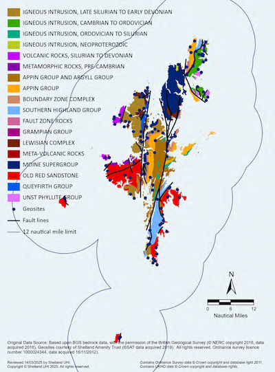
Shetland’s geology is remarkably complex, featuring a wide variety of rock types concentrated within a relatively small area, making it one of the most geologically diverse places on Earth. This geological richness has shaped a varied and intricate coastline which in turn influences the species, habitats and communities found around the coast. Shetland’s dynamic marine environment supports a diverse range of habitats and species that are also of significant cultural and socio-economic importance.
Shetland boasts marine natural heritage features and designated areas of international, national, and local significance. Alongside their recognised conservation importance these habitats and species, both directly and indirectly, support a wide range of goods and services including wild fisheries, tourism, recreation, carbon sequestration, coastal protection and cultural heritage. This natural capital has benefited the people of Shetland since the earliest evidence of human activity around 4300 BC.
Recognising the value and vulnerability of this natural capital, strategic action is essential to ensure its protection and enhancement, an approach reflected nationally within the Scottish Government’s Scottish Biodiversity Strategy to 2045. The strategy acknowledges the urgent and transformative action needed to tackle the current crises of biodiversity loss and climate change. Its vision is that:
“By 2045, Scotland will have restored and regenerated biodiversity across our land, freshwater and seas. Our natural environment, our habitats, ecosystems and species, will be diverse, thriving, resilient and adapting to climate change. Regenerated biodiversity will drive a sustainable economy and support thriving communities and people will play their part in the stewardship of nature for future generations.”[22]
The SIRMP supports this vision of a thriving, resilient natural environment by safeguarding and enhancing both biodiversity and geodiversity. It does this through the protection of sites and features of international, national and local importance, as well as the wider marine and coastal environment. The policies within this section of the SIRMP are designed to protect sites, habitats, and species from loss or damage taking account of:
- the hierarchy of designations of international, national and local importance;
- the irreplaceability of habitats, sites and/or features and their contribution to the broader ecological network across Shetland’s terrestrial and marine environments;
- the potential impact on priority marine features and/or habitats and protected or priority species.
Under Section 1 of the Nature Conservation (Scotland) Act 2004, public bodies in Scotland have a duty, when exercising any functions, to further the conservation of biodiversity, so far as is consistent with the proper exercise of those functions.
In addition to the policies within the SIRMP, applicants should also take account of policies relating to natural heritage within Scotland’s National Marine Plan (NMP), Shetland Islands Council’s Local Development Plan (SIC LDP) and Scotland’s National Planning Framework 4 (NPF4).
Baseline information on the current state of Shetland’s natural and historic environments can be found in Shetland Islands Marine Region State of the Environment Assessment.
Maps within this section are complex with many overlapping layers, to view specific areas in more detail visit the Scottish Government NMPi website.
Applicants should use the spatial information on important natural heritage features within the SIRMP and Shetland Islands State of the Environment Assessment to inform their proposals and pre-application discussions. Whilst the SIRMP brings this information together, data gaps likely remain so applicants are advised to contact the appropriate data holder for more detailed information.
Natural Heritage - Protected Sites and Species
Marine habitats and species in Scotland are protected by a range of national and international legislation. Shetland’s unique and diverse species and habitats have led to the designation of numerous internationally, nationally and locally protected sites. This forms a network of Marine Protected Areas (MPAs) which helps to safeguard Shetland’s important wildlife, habitats, geology and undersea landforms, along with coastal habitat protections such as SSSIs and Local Nature Conservation Sites (LNCSs). Legislation also helps protect rare and vulnerable species, as well as their breeding and resting places.
Policy MP BIOD1: Protected sites and species
Proposals for marine development and use must comply with all legal requirements for protected areas and protected species, and should consider potential direct and indirect effects, including disturbance and any cumulative impacts.
Internationally designated sites
Proposals that may affect a European Site (Special Areas of Conservation and Special Protection Areas) must comply with the relevant legislation and will only be supported where they meet the relevant statutory tests.
All Ramsar sites are also European Sites and/or Sites of Special Scientific Interest (SSSIs) and are extended protection under the relevant statutory regimes.
Nationally designated sites
Proposals that could affect Nature Conservation MPAs or Demonstration and Research MPAs must comply with the relevant legislation for these protected areas.
Proposals that could affect a SSSI or National Nature Reserve must comply with the relevant legislation for these protected areas.
Seal Haul-Out Sites
Proposals that could affect a designated seal haul-out site should consider how they will avoid harassment of seals. Applicants should have regard to the Harassment at Seal Haul-Out Sites: Guidance.
Local Nature Conservation Sites
Proposals that could affect a site designated as a Local Nature Conservation Site (LNCS) should have regard to Shetland Islands Council’s Local Development Plan and its Supporting Guidance on LNCS.
Protected Species
Proposals for marine development or use that are likely to have an adverse effect on species protected by legislation will only be supported where the proposal meets the relevant statutory tests.
If there is reasonable evidence to suggest that a protected species is present, or may be affected by a proposal, steps must be taken to establish their presence. Applicants should consider within the planning and design of the proposal the level of protection afforded by legislation and should fully consider any impacts to protected species.
Justification and Considerations
Protected Sites
The network of designated sites in Shetland provides layers of statutory and non-statutory protection to support Shetland’s most important and sensitive species and habitats underpinned by legislation. Table 1a-c details the types of protected areas within the Shetland Islands Marine Region.
Table 1a: Internationally designated areas within the Shetland Islands
Internationally Designated Sites
Designation:
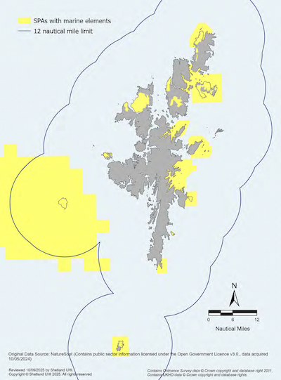
Special Protection Areas (SPAs)
- SPAs are designated to protect one or more rare, threatened or vulnerable bird species.
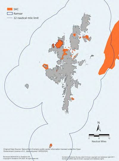
- SPAs and SACs together are known as European Sites. There are 15 SPAs in Shetland, 14 of which are designated for seabirds.
- Map: Map 7
Special Areas of Conservation (SACs)
- SACs are designated to conserve one or more protected habitats and/or species.
- SACs and SPAs together are known as European Sites. There are 7 SACs in Shetland with a marine element, designated for features such as lagoons, reefs, harbour seals and European otters.
- Map: Map 8
Ramsar sites
- Ramsar sites are internationally protected wetland areas. They are afforded the same protections as European Sites in Scotland. There is one Ramsar site at Ronas Hill – North Roe and Tingon, designated for its upland bog area.
- Map: Map 8
Important Marine Mammal Area (IMMA)
- An area identified as being important for marine mammals. In Shetland an area covering 14,208km2 has been designated due to the variety of marine mammal species in the region. IMMAs designations are non-statutory.
- Map: No map required
Important Shark and Ray Area (ISRA)
- An area identified as being important for shark and ray species. In Shetland two areas have been identified, one for flapper skate around Fair Isle and a second for thornback ray in Swarbacks Minn, southeast of St Magnus Bay. ISRA designations are non-statutory.
- Map: No map required
Table 1b: Nationally designated areas within the Shetland Islands
Nationally Designated Sites
Designation:
Nature Conservation MPAs (NCMPAs)
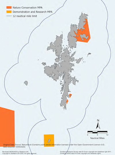
- NCMPAs are marine regions where nationally important species, habitats and geomorphology (landforms and natural processes) are protected. There are two NCMPAs in Shetland, ‘Fetlar to Haroldswick’ and ‘Mousa to Boddam’.
- Map: Map 9
Demonstration & Research MPAs (DR MPAs)
- Designated for the purpose of demonstrating and conducting research on sustainable methods of marine management or exploration in territorial waters. There is one DR MPA covering the waters around Fair Isle.
- Map: Map 9
Sites of Special Scientific Interest (SSSIs)
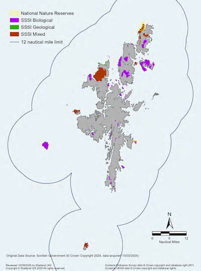
- SSSIs are areas above MHWS that NatureScot considers best represent Scotland’s natural heritage. Many are also designated as European Sites (SPAs or SACs).
- There are 78 SSSIs in Shetland, 31 are notified for marine biological features including seabirds, and 36 are coastal sites notified for geological and geomorphological features, although on five of these the geological interest does not extend down to MHWS. A further two geological sites are within 100m of MHWS.
- Map: Map 10
National Nature Reserves (NNRs)
- Non-statutory protection for nationally and internationally important species and habitats.
- Shetland has two coastal NNRs, Noss and Hermaness, both of which are also SSSIs. The reserves are managed by NatureScot.
- Map: Map 10
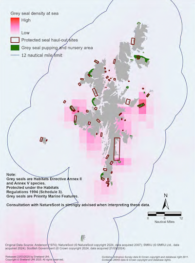
Designated Seal Haul-Out Sites
- Designated by the Scottish Government to provide additional protection for seals at defined haul-out sites. There are 47 sites within the Shetland Islands Marine Region.
- Map: Map 12a & 12b
Table 1c: Locally designated areas within the Shetland Islands
Locally Designated Sites
Designation:
Local Nature Conservation Sites (LNCSs)
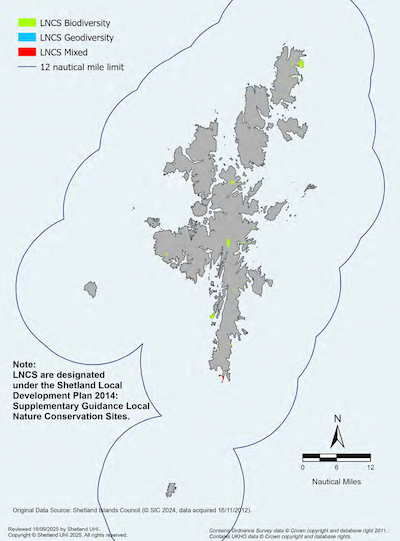
- Non-statutory protected areas identified by the Shetland Islands Council to highlight sites of conservation value at a local level. There are 49 sites, some of which include coastal features and seabirds.
- Map: Map 11
Local Habitat Protected Areas
- Protect habitats and species sensitive to disturbance. Areas were identified by the Shetland Shellfish Management Organisation using local knowledge provided by the inshore fishing industry. These areas are closed to dredge fishing.
- Map: Map 22
Development Restricted Areas
- Designated by the Shetland Islands Council to protect important habitats (including seagrass beds and saltmarsh), visual amenity and recreational opportunities as part of their Works Licence Policy and Aquaculture Supplementary Guidance to the Local Development Plan.
- Map: Map 32
Internationally Designated Sites
European sites are protected under The Conservation (Natural Habitats &c.) Regulations 1994 (as amended) (known as the ‘Habitats Regulations’). These regulations require that a competent authority must determine, through a Habitats Regulations Appraisal (HRA), whether the proposed development or use is likely to have a significant effect on a European Site (including Ramsar sites), either alone or in combination with other plans or projects. If it is determined that there may be a likely significant effect, the proposal must proceed to an Appropriate Assessment (AA). The proposal may only proceed if it can be ascertained that it will not adversely affect the integrity of the site.
In some instances, the competent authority may wish to consent a proposal despite the potential for an adverse effect on site integrity. Where this is the case, it must first show there are no alternative solutions, and that it is imperative, and of overriding public interest to grant consent. Scottish Ministers must be consulted, and any necessary compensatory measures must also be taken to ensure the overall coherence of the protected sites’ network.
It is strongly advised that applicants consult relevant consenting authorities and organisations such as NatureScot during the early stages of a proposal and provide any information the competent authority may reasonably require for the purpose of an Appropriate Assessment.
The competent authority is advised to consult NatureScot when determining likely significant effects and should have regard to any recommendations they may make.
Important Marine Mammal Areas (IMMAs)
The waters around Shetland have been designated as an important region for marine mammals due to the wide variety of marine mammals that use the area. IMMAs are non-statutory but serve to highlight areas critical for feeding, breeding, migration or social behaviour and can help inform planning decisions, and research and conservation efforts.
Important Shark and Ray Areas (ISRAs)
Two areas in Shetland have been identified as ISRAs based on scientific criteria that describe an areas importance for the survival and well-being of shark or ray species. In Shetland, this includes the flapper skate around Fair Isle and thornback ray in Swarbacks Minn, an area located in the southeast of St Magnus Bay.
Nature Conservation MPAs (NCMPAs) & Demonstration and Research MPAs (DR MPAs)
The Marine (Scotland) Act 2010 places a range of duties on public authorities relating to the protection of Nature Conservation MPAs in view of their stated conservation objectives. It is strongly advised to contact NatureScot in the early stages of a development that may impact a NCMPA.
It is not the intention of DR MPA to introduce restrictions on existing or normally sustainable activities. Voluntary agreements between stakeholders are encouraged, however, restrictions may be introduced if they are necessary to support the demonstration and research objectives of the site.
Seal Haul-Out Sites
Scottish Ministers, in consultation with the Natural Environment Research Council (NERC), under the Marine (Scotland) Act 2010, are permitted to designate specific Seal Haul-Out Sites to provide additional protection to seals from intentional or reckless harassment. Seal Haul-Out Sites are designated through The Protection of Seals (Designation of Haul-Out Sites) (Scotland) Order 2014.
In addition, under the Marine (Scotland) Act 2010, Shetland is one of five Seal Conservation Areas for harbour seals. It is strongly advised that consultation in relation to the conservation of seals is carried out with the Seal Licensing Team at MD-LOT.
Sites of Special Scientific Interest (SSSI)
SSSIs are statutory designations made by NatureScot under the Nature Conservation (Scotland) Act 2004. NatureScot designates SSSIs in areas above MHWS which best represent Scotland’s Natural Heritage in terms of their flora, fauna, geology, geomorphology or a mixture of these natural features. It is strongly advised to contact NatureScot in the early stages if a development proposal.
National Nature Reserves (NNRs)
NNRs are non-statutory protections for nationally or internationally important species and habitats managed by NatureScot. It is advised to contact NatureScot at the early stages of a proposed development or activity which may impact a NNR.
Local Nature Conservation Sites (LNCSs)
LNCs, designated by Shetland Islands Council (SIC), identify sites of nature conservation value at a local level. The SIC does not seek to prohibit development within LNCS but be a means of providing developers with information on the sensitive features present within a site. The identification of these sites early in the planning process will allow avoidance of potential negative impacts on the integrity of these sites.
Justification and Considerations
Protected Species
Some species are afforded special protection from disturbance and damage, and protection of their breeding and resting sites under the following key pieces of legislation:
- The Wildlife and Countryside Act 1981 (as amended);
- The Conservation (Natural Habitats &c.) Regulations 1994 (as amended) (known as ‘The Habitats Regulations’); and
- Marine (Scotland) Act 2010.
Table 2 details information and map numbers for protected species within the Shetland Islands Marine Region.
Table 2: Protected species within the Shetland Islands Marine Region
Protected Species:
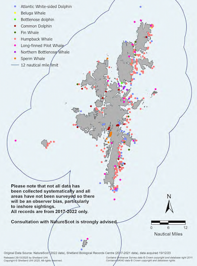
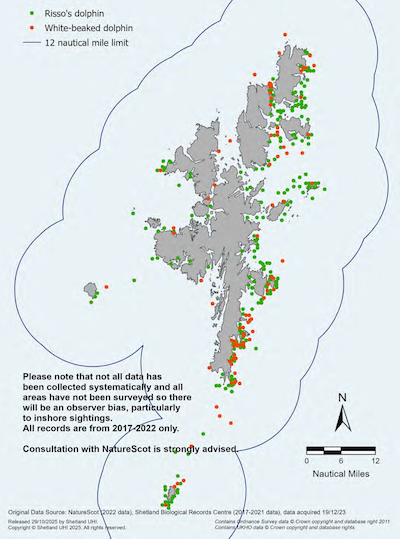
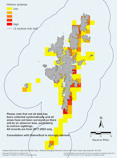
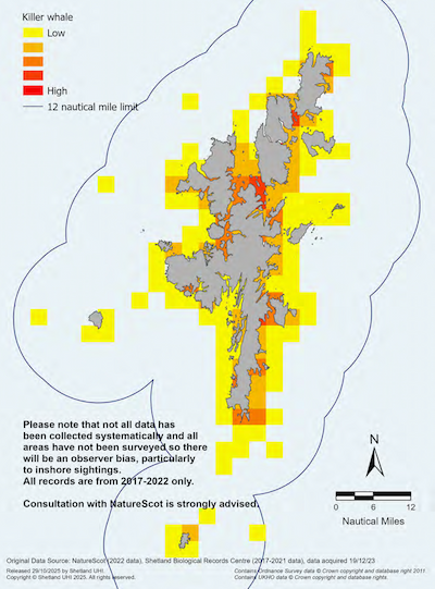
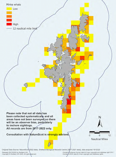
- Records of cetacean sightings
- Vagrant cetacean species
- Risso’s and white-beaked dolphins
- Harbour porpoise
- Killer whale
- Minke whale
Map:
- Map 13 (a-e)
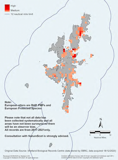
Protected Species:
- European otter sightings
Map:
- Map 14
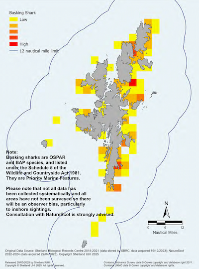
Protected Species:
- Basking shark sightings
Map:
- Map 15
Protected Species:
- Distribution of
- Breeding seabird colonies
- Wintering seabirds
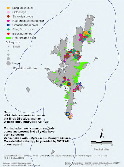
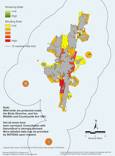
- Common eider
Map:
- Map 16 (a-c)
Protected Species:
- Distribution of
- Harbour seals at sea and on land
- Grey seals at sea and on land
Map:
- Map 12 (a & b)
The Wildlife and Countryside Act 1981 (the ‘1981 Act’), as amended by the Nature Conservation (Scotland) Act 2004 and the Wildlife and Natural Environment (Scotland) Act 2011 (the ‘WANE Act’), is the primary legislation protecting animals, wild birds, plants and certain habitats in Scotland. It details what constitutes an offence against:
- any wild bird, their eggs or nests (Section 1).
- animal species listed in Schedule 5, including offences related to areas used for resting (Section 9).
The Habitats Regulations afford protection to certain species listed in the Habitats Directive including species in need of strict protection. The species listed in Annex IV of the Habitats Directive are called ‘European Protected Species’ (EPS). Marine EPS whose natural range includes any area in Scottish waters (both inshore and offshore) include European otters, basking sharks, whales, dolphins and porpoises.
For European Protected Species, an EPS licence may be granted to carry out an activity which otherwise would have been deemed unlawful under the Habitats Regulations. An EPS licence can only be granted subject to three strict tests being met. More information on the tests is available on the NatureScot website.
While certain species are protected under the 1981 Act, there are specific circumstances where a licence may be issued to authorise activities that would otherwise be considered offences under the 1981 Act. These circumstances are outlined in Section 16 of the 1981 Act.
For detailed information on what constitutes an offence under the Habitats Regulations, refer to the Scottish Government's The protection of Marine European Protected Species from injury and disturbance.
Applicants and decision makers should seek advice from NatureScot and RSPB Scotland on seasonal sensitivities of species.
Key Consultees
- Marine Directorate – Licensing Operations Team
- NatureScot
- Shetland Islands Council
- Fair Isle Marine Research Organisation
Further Information
- UHI Shetland – Shetland Islands Marine Region State of the Environment Assessment
- JNCC- UK Protected Areas
- NatureScot- Protected Areas
- Scottish Government – Marine Protected Areas
- Scottish Government – Marine licensing and consent
- Scottish Government – ‘The protection of Marine European Protected Species from injury and disturbance’.
- Scottish Government – Biodiversity Strategy to 2045
- Scottish Government – National Planning Framework 4
- Shetland Islands Council – Local Development Plan
- Shetland Islands Council LDP – Local Nature Conservation Site Supplementary Guidance
- Shetland Islands Council – Natural Heritage
- NatureScot – EPS Licensing
- Scottish Government Seal Haul-out Sites
- Scottish Government – ‘Harassment at seal haul-out sites: guidance’
- Blue Connect Shetland
- Sea Mammal Research Unit
- Marine Mammal Protected Areas Task Force – Shetland and Fair Isle IMMA
- Important Shark and Ray Areas
- RSPB- Wildlife & Bird Protection Laws UK


Natural Heritage: Priority Marine Features
NatureScot and the Marine Directorate have identified the most important components of Scotland’s marine biodiversity. Priority Marine Features (PMF) are a prioritised list of 81 marine habitats and species considered to be of national conservation importance. These species and habitats provide a range of services, including acting as a carbon sink, providing nursery grounds for commercial species and reducing coastal erosion. They should be taken into account in Environmental Statements and through relevant licensing/consenting decisions.
The SIRMP provides a mechanism for the protection of Priority Marine Features which lie both within and outside formally designated MPAs. Forty-four PMF species and habitats are known to be present in waters around Shetland. These features are considered to be of both local and national importance and should be safeguarded in order that ecosystem health is maintained.
Policy MP BIOD2: Priority Marine Features
Proposals must not result in significant negative impacts on the national status of Priority Marine Features (PMFs).
Applicants should consider if impacts will affect PMFs in Shetland.
Applicants should consider mitigation measures, including alternative locations, where potential adverse impacts on PMFs are identified.
Justification and Considerations
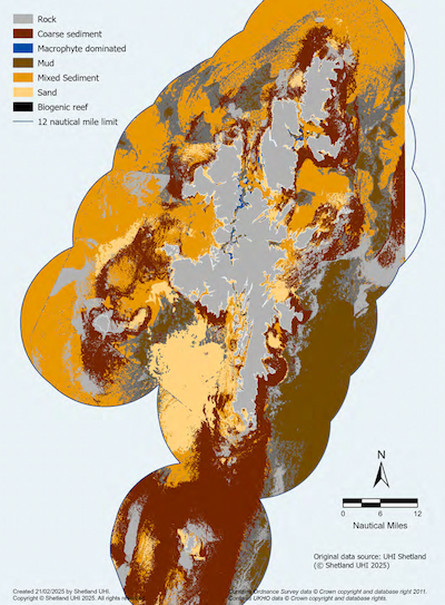
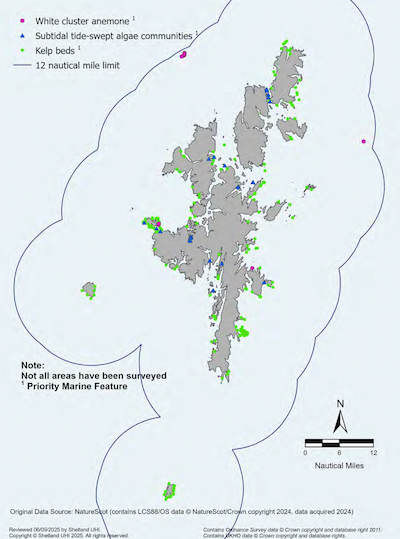
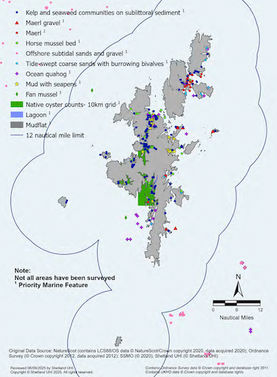
NatureScot’s PMF List names all Priority Marine Features in Scottish Seas. Spatial information on the known distribution of some of Shetland’s PMFs are included in Maps 12 to 22 and within the Shetland Islands Marine Region State of the Environment Assessment, although data gaps remain. Additionally, the Shetland Shellfish Management Organisation (SSMO) commissioned UHI Shetland to use predictive mapping techniques to indicate where PMF species and habitats might occur and have been shared with the Shetland Islands Marine Planning Partnership for inclusion in the SIRMP.
Table 3 details information and map numbers for PMFs within the Shetland Islands Marine Region, including cetaceans, seals, European otters, and basking sharks. Important marine habitat maps indicate whether a species is a PMF in the map legend.
This policy provides protection to species and habitats of most conservation importance in Scottish waters. These species and habitats provide a range of services, including acting as carbon sinks, providing nursery grounds for commercial species and reducing coastal erosion. Where possible, the status of PMF features should be considered within the Shetland context, for example, if PMFs are known to be locally rare or vulnerable.
Table 3: Priority Marine Features within the Shetland Islands Marine Region
Species and Habitats:
- Distribution of
- Harbour seals at sea and on land
- Grey seals at sea and on land
Maps:
- Map 12 (a & b)
Species and Habitats:
- Records of cetacean sightings
- Vagrant cetacean species
- Risso’s and white-beaked dolphins
- Harbour porpoise
- Killer whales
- Minke whales
Maps:
- Map 13 (a-e)
Species and Habitats:
- European otter sightings
Maps:
- Map 14
Species and Habitats:
- Basking shark sightings
Maps:
- Map 15
Species and Habitats:
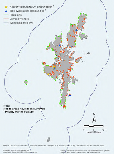
- Intertidal rock distribution and supported habitats
Maps:
- Map 17
Species and Habitats:
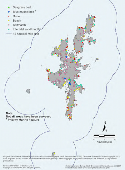
- Intertidal sediment distribution and supported habitats
Maps:
- Map 18
Species and Habitats:
- Intertidal sediment distribution and supported habitats
Maps:
- Map 18
Species and Habitats:
- Modelled subtidal sediment
Maps:
- Map 19
Species and Habitats:
- Subtidal rock distribution and supported habitats
Maps:
- Map 20
Species and Habitats:
- Subtidal sediment distribution and supported habitats
Maps:
- Map 21
Key Consultees
- Marine Directorate – Licensing Operations Team
- NatureScot
Further Information
- Shetland Islands Council – Local Development Plan and relevant Supplementary Guidance
- NatureScot – Priority marine features in Scotland’s seas
- NatureScot – Priority marine features- The List
- UHI Shetland – PMF Guide
- UHI Shetland – Shetland Islands Marine Region State of the Environment Assessment
- Shetland Islands Council – Natural Heritage
- Scottish Government – Biodiversity Strategy to 2045
- Scottish Government – Scotland’s National Marine Plan
- Marine Life Information Network
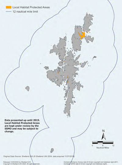
Natural Heritage: Local Habitat Protected Areas
The Shetland Shellfish Management Organisation (SSMO) has worked closely with the inshore fishing industry to create areas closed to dredge fishing to protect areas of seabed which support sensitive species and habitats.
Policy MP BIOD3: Local Habitat Protected Areas
Proposals for marine development and use should consider potential impacts on SSMO closed areas.* Where a proposal may have an adverse direct or indirect effect on the priority marine features protected within an SSMO closed area, applicants may be required to demonstrate:
- a) there will be no adverse effects on the national status of the PMF, or the status of the PMF in Shetland; or
- b) there are no reasonable alternatives or less ecologically damaging locations; and
- c) mitigation measures to minimise the impacts on the priority marine features have been considered.
*Those which were in place by December 2019
Justification and Considerations
Local Habitat Protected Areas represent some of Shetland’s best examples of important habitats sensitive to disturbance such as horse mussels, maerl and seagrass beds. These habitats provide a range of goods and services, including, acting as a carbon sink, and helping to stabilise soft sediments. The protection provided by the SSMO and SIRMP gives a consistent management approach to these habitats in Shetland.
Local Habitat Protected Areas are shown in Map 22. Further details on the sensitive species and habitats protected within these habitats can be found on NMPi as a layer under Fishing Managed Areas titled ‘Areas where fishing with dredges is restricted.’
Key Consultees
- SSMO
Further Information
Natural Heritage: Wider Seas Measures
Biodiversity is all of life: animals, plants, fungi and microorganisms and their interactions with their environment. Together, these form living systems, called ecosystems, which sustain nature and upon which our own survival depends.
The latest State of Nature Report highlights a continuing decline in the UK’s wildlife, with climate change and marine development identified as key pressures in the marine environment. At the same time, there is growing recognition of the vital role healthy ecosystems play, not only in maintaining biodiversity, but also in helping to mitigate climate change.
The Scottish Government's Biodiversity Strategy to 2045 outlines a comprehensive plan to halt biodiversity loss by 2030 and to have restored and regenerated biodiversity in Scottish seas by 2045, setting a vision for a nature-positive Scotland.
Policy MP BIOD4: Furthering the Conservation of Biodiversity
Development and use of the marine environment must protect and, where appropriate, enhance the health of Shetland’s marine area so far as is consistent with the exercise of functions relating to the proposed development or use.
Where proposals may have a significant adverse effect on biodiversity or the ecosystem services of biodiversity, including any cumulative impact, the applicant should further consider measures to avoid, minimise, or mitigate any harm or disturbance to the ecosystem services, continuity, and integrity of the habitats or species affected.
Applicants should consider impacts on areas which are important to all aspects of a species’ life cycle including locations used for breeding, nesting, resting, foraging and seasonal use, including overwintering.
Justification and Considerations
This policy supports a Nature Positive future for Scotland, and the Scottish Biodiversity Strategy’s outcome for marine and coastal environments that by 2045:
“The health, condition, and resilience of pelagic, coastal, shelf and deep sea marine habitats will have been restored, supporting wider ecosystem function, providing increased benefits to society, and contributing to climate resilience and adaption through nature-based solutions”[23]
Applicants are advised to consider where actions may be available to enhance marine species and habitats as part of the marine development or use. To assist developers, a set of guiding principles and key themes has been co-developed by the Shetland community and local stakeholders to help guide marine restoration and enhancement in Shetland.
Under the Nature Conservation (Scotland) Act 2004, public bodies in Scotland have a duty to further the conservation of biodiversity, so far as is consistent with the proper exercise of their functions.
Applicants and planners are strongly encouraged to seek advice on sensitive species from relevant authorities such as the Marine Directorate – Licensing Operations Team, NatureScot and Shetland Islands Council’s Natural Heritage Team on sensitive species.
Key Consultees
- Marine Directorate – Licensing Operations Team
- NatureScot
Further Information
- UHI Shetland – Shetland Islands Marine Region State of the Environment Assessment
- Shetland Islands Council – Local Development Plan
- Scottish Government – Scottish Biodiversity Strategy to 2045
- Scottish Government – Biodiversity: delivery plan 2024 to 2030
- Scottish Government – Marine Licensing and Consents
- Scottish Government – Scotland’s National Marine Plan
- Scottish Government – National Planning Framework 4
- Scottish Government – Draft Planning Guidance: Biodiversity
- UHI Shetland – Guiding Marine Restoration and Enhancement in the Shetland Islands
- Shetland Islands Council – Natural Heritage
- UHI Shetland – Native Species
- Marine Life Information Network
Natural Heritage- Geodiversity
Geodiversity is the variety of rocks, fossils, minerals, natural processes, landforms and soils that underlie and determine the character of our landscape and environment. Geodiversity is all around us. It influences the way we live, the resources we need and use, and how the world changes. Understanding and valuing geodiversity is critical to understanding the Earth and the decisions we make for the future of our environment.
Shetland's designation as a Geopark places it within the exclusive European Geopark Network and UNESCO Global Geoparks. One element of the Geopark label is the designation of Geosites- sites important for their geology. For more information see the Geopark Shetland Feature Box.
Policy MP GEOD1: Safeguarding Marine Geodiversity
Proposals for marine development and use should consider potential impacts on geodiversity and appropriate measures to protect or enhance marine and coastal geological and geomorphological resources and sites. This includes the protected geological features of SSSIs and MPAs, Geological Conservation Review sites, and Geosites identified by Geopark Shetland for their educational or research value.
Where proposals would have unavoidable adverse effects on marine geodiversity, applicants should consider recording the affected geodiversity and identifying mitigation measures to reduce marine geodiversity loss.
Justification and Considerations
Geosites and an overview of Shetland’s geology are shown in Map 23 and SSSIs designated for geological features are shown in Map 11.
Geodiversity plays a crucial role in maintaining the natural environment’s ability to provide important ecosystem services. It contributes to:
- provisioning services: fresh water (surface and ground water), mineral resources (including oil and gas, renewable energy);
- regulating services: carbon sequestration and climate regulation, reducing erosion and natural hazards such as flooding;
- supporting services: soil formation, geomorphological processes, terrestrial and marine habitats;
- cultural services: aesthetic values, landscape character, resources for recreation and outdoor activities, tourism, and education and lifelong learning.
The loss of geodiversity or its mismanagement as a consequence of factors such as unsustainable development, changing land use or climate change, presents real threats to biodiversity and can result in significant economic and social costs. Conversely, the sustainable management of geodiversity can have positive economic, social, cultural and educational benefits. It is a misconception that geodiversity is robust enough not to require management and protection.
Key Consultees
- NatureScot
- Shetland Amenity Trust
Further Information
- UHI Shetland – Shetland Islands Marine Region State of the Environment Assessment
- Shetland Islands Council – Local Development Plan and Supplementary Guidance Local Nature Conservation Sites
- Scottish Government – Scotland’s National Marine Plan
- Scottish Government – National Planning Framework 4
- Shetland Amenity Trust – Geopark Shetland
- Scottish Geology Trust
- Scottish Geodiversity Charter
- Shetland Geological Society
Geopark Shetland
A Geopark is an area or territory with geological heritage of international significance. Geoparks use that heritage to promote sustainable development, primarily through tourism and education. Geoparks take a holistic approach to interpretation, highlighting the close links between geodiversity and cultural and natural heritage. They also raise awareness of key issues facing society in the context of the dynamic planet we live on, such as climate change and geological hazards like volcanoes, earthquakes and tsunamis. Geoparks seek to conserve the natural environment and encourage sustainable use of natural resources. They are supported by UNESCO.
Geopark Shetland aims to safeguard and increase the awareness and understanding of Shetland’s rich geological heritage and to use this as a driver for sustainable development by:
- Conserving Shetland’s rich geological heritage and demonstrating its clear links with natural and cultural heritage.
- Raising awareness and increasing understanding of Shetland’s geological heritage.
- Enhancing the image of Shetland and promoting sustainable development linked to geological heritage and geotourism.
Geopark Shetland is supported by the Geopark Shetland Working Group (GSWG). The GSWG includes representatives from several partners from heritage, tourism, education and community groups and organisations.
People and Place
The Shetland Islands are remote, located closer to Bergen in Norway than to Aberdeen on mainland Scotland. This isolation has fostered a strong sense of community and self-reliance among the inhabitants. The stunning landscapes and seascapes, with their rugged coastlines, cliffs and beaches, play a significant role in the daily lives of Shetlanders. The natural beauty and the challenges of living in such an environment contribute to a strong bond with the land and sea. Traditional industries such as fishing, crofting and knitting are integral to Shetland’s culture. These activities not only provide livelihoods but also help maintain a connection to the islands’ heritage and natural resources.
Shetland’s cultural identity is deeply rooted in its rich history which dates back to the Neolithic period. The islands were significantly influenced by Norse culture following Viking invasions around 800 CE. This Norse heritage is still evident today in place names, traditions and the local dialect.
Shetland’s historic environment includes all aspects of the environment resulting from the interaction between people and places through time, including all surviving physical remains of past human activity, whether visible, buried or submerged. It helps to give a sense of place, well-being and cultural identity and enhances regional and local distinctiveness. It is important that this inheritance is managed and protected so that future generations will be able to enjoy it.
Marine recreation is important to locals and visitors, providing both tangible and non-tangible benefits. Marine tourism, including activities like boating, diving, and wildlife watching, significantly contribute to the local economy by attracting visitors and creating jobs. Recreational activities in marine settings promote physical health and mental well-being, whilst also providing opportunities for social interaction and community engagement. Marine recreation helps raise awareness about the importance of preserving marine ecosystems and encourages sustainable practices and fosters a connection between people and the natural environment.
People and Place- Landscape and Seascape
Marine development and use within the coastal zone has the potential to have both a positive and negative impact on the landscape including seascapes. The effects will be specific and dependent on the type of development or activity, its location and setting. The definition of landscape, according to the European Landscape Convention (ELC), is “an area, as perceived by people, whose character is the result of the action and interaction of natural and/or human factors”.[24] However, there is no legal definition, as yet, of ‘seascape’ in the UK. For the purposes of the SIRMP, references to seascape should be taken as meaning “landscapes with views of the coast or seas, and coasts and the adjacent marine environment with cultural, historical and archaeological links with each other”.[25]
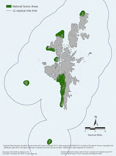
National Scenic Areas (NSA)
The quality of Shetland’s landscape has been recognised nationally by the designation of a National Scenic Area (NSA) under the Town and Country Planning (Scotland) Act 1997 (as amended). Seven separate areas of coastal landscape have been identified as being of outstanding scenic interest and form the Shetland NSA. The Shetland NSA has an essentially coastal character which contributes strongly to the special qualities of the areas defined.
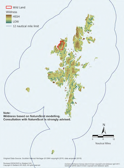
Wildness and Wild Land Areas
Wild Land Areas are described by NatureScot as “the most extensive areas of high wildness”.[26] Wildness is a landscape quality which is experienced by an individual. An area of wild land has been identified by NatureScot within Shetland covering areas at Ronas Hill and North Roe. The varied and diverse coastal character contributes strongly to the wild land quality of this Wild Land Area.
Policy MP VIS1: Safeguarding the National Scenic Area (NSA)
Proposals for marine development and use should consider the potential impacts on the Shetland National Scenic Area (NSA).
Proposals should only be permitted where:
- a) the proposal will not adversely affect the integrity of the area or the special qualities for which it has been designated, or
- b) any such adverse effects are clearly outweighed by social, environmental, or economic benefits of national importance.
Policy MP VIS2: Safeguarding Seascape Character and Visual Amenity
Proposals for marine development and use should consider the potential impacts on landscape, seascape, and visual amenity and should seek to minimise adverse impacts through careful planning and design. This could include consideration of:
- a) how the proposal takes into account the existing character and quality of the local landscape/seascape; how highly it is valued; and its capacity to accommodate change specific to any development; and
- b) a high standard of design, in terms of siting, scale, colour, materials and form to ensure the various types of development or coastal use change proposed can be accommodated within particular landscape and seascape types.
Justification and Considerations
National Scenic Areas are shown in Map 24. Seascape character assessment is shown in Map 25. Areas of wildness and the Wild Land Area are shown in Map 26.
Landscapes including areas of coastal wild land or isolated coasts are sensitive to inappropriate activity and development. It can bring about change that can damage existing features, diminish wildlife in ecological areas and neglect traditional features, all of which have important implications for the landscape qualities of the Shetland Islands. However, some change is not only inevitable but also desirable and whilst the protection of the landscape and natural heritage may sometimes impose constraints on development, the SIRMP aims to facilitate positive change whilst maintaining and enhancing distinctive character.
Some marine development and use may have an impact on the NSA by virtue of their proximity, scale and design; therefore, stricter planning control should be enforced as appropriate. Applicants are also required to submit a Design Statement alongside planning applications for new aquaculture developments that fall within the Shetland NSA and for ‘major’ developments which cover a surface area of 2 hectares or above. It is recommended that consenting authorities have regard to the NSA Special Qualities Statements for Shetland published by NatureScot.
All new marine development and use should have regard to the SIC LDP. For proposals that require an Environmental Impact Assessment (EIA), a Landscape and Visual Impact Assessment (LVIA) is usually also required when there are likely to be negative effects on the landscape. There may also be occasions where such assessment is requested even if an EIA is not required. The following documents and guidance can support these assessments.
- Guidelines for Landscape and Visual Impact Assessment 3rd edition (LI & IEMA), 2013 (GLVIA3)
- UHI Shetland – Shetland’s Coastal Character Assessment
- Naturescot – Landscape Character Assessment: Shetland – Landscape Evolution & Influences
Applicants and consenting authorities should ensure that potential effects, including the cumulative effect of incremental changes, are considered when deciding planning, works licence and marine licence applications. It is recommended that applicants consult with the relevant consenting authorities as early as possible when proposing any new or revised development or activity.
Key Consultees
- NatureScot
- · Shetland Islands Council
Further Information
- UHI Shetland – Shetland’s Coastal Character Assessment
- UHI Shetland – Shetland Islands Marine Region State of the Environment Assessment
- Shetland Islands Council – Local Development Plan
- Scottish Government – Scotland’s National Marine Plan
- Scottish Government – National Planning Framework 4
- NatureScot – Scottish Landscape Character Types Map and Descriptions
- NatureScot – Landscape Character Assessment: Shetland – Landscape Evolution & Influences
- NatureScot – Wild Land Areas Descriptions
- NatureScot – Landscape and Visual Impact Assessment
- NatureScot – Safeguarding protected areas and species
- NatureScot – Assessing Impacts on Wild Land Areas: Technical guidance
- Landscape Institute – Guidelines for Landscape and Visual Impact Assessment
- NatureScot Commissioned Report 374: The special qualities of National Scenic Areas
People and Place- Historic Environment
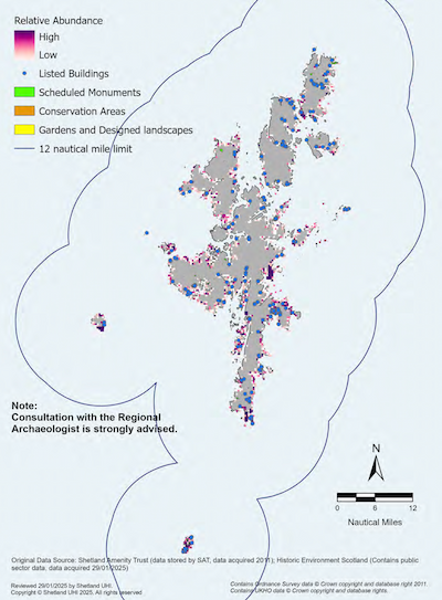
Elements of Shetland’s historic environment such as buildings, monuments, sites or landscapes which are deemed significant are often collectively termed ‘heritage assets’. Far less is known about heritage surviving on the seabed than heritage assets on land. As our knowledge increases, it is becoming clear that Shetland’s coasts and seas contain a rich cultural heritage that includes the remains of important heritage assets of all periods from prehistory to the recent past. Marine historic assets around our coast include: the wrecks of boats, ships, submarines and aircraft; harbours, lighthouses and other built structures; drowned terrestrial archaeological sites and cultural landscapes.
Many of these assets are unique and valuable but some are not well understood and cannot be replaced if lost or damaged. The marine historic environment requires careful and active management to ensure that it persists. The SIRMP supports the priorities set out in the Scottish Government’s- ‘Our Past, Our Future: The Strategy for Scotland’s Historic Environment 2023-2028’
Legislation
Some significant heritage assets are designated and protected under national legislation. Designated heritage assets may include scheduled monuments (designated under the Ancient Monuments and Archaeological Areas Act 1979), listed buildings (designated under the Planning (Listed Buildings and Conservation Areas) (Scotland) Act 1997) and Historic Marine Protected Areas (designated under the Marine (Scotland) Act 2010). These assets can be found from the coast through to offshore areas. Military maritime graves of individual wrecked vessels and all crashed military aircraft are designated under the Protection of Military Remains Act 1986, which is administered by the Ministry of Defence.
Coastal and Marine Archaeology
Shetland’s archaeology is a key part of what gives the islands their distinctive and unique character. The archaeology includes Scheduled Monuments but also includes many other sites which are of ‘schedulable’ quality. Examples of nationally and locally important heritage assets around Shetland include:
- scheduled ancient monuments;
- historic plane wrecks and designated shipwrecks;
- brochs and burnt mounds;
- any associated marine buildings such as bods, piers, sea walls; and
- protected wrecks and unscheduled monuments with significant value.
The Shetland Islands Council provides a Regional Archaeology Service (RAS). They are responsible for maintaining an up-to-date record known as the Shetland Sites and Monuments Record (SMR). The SMR currently holds information on around 9,000 sites, a high proportion of which are coastal/marine. Archaeology, once designated at a site, denotes the ‘dominant use’ for cultural and historic reasons.
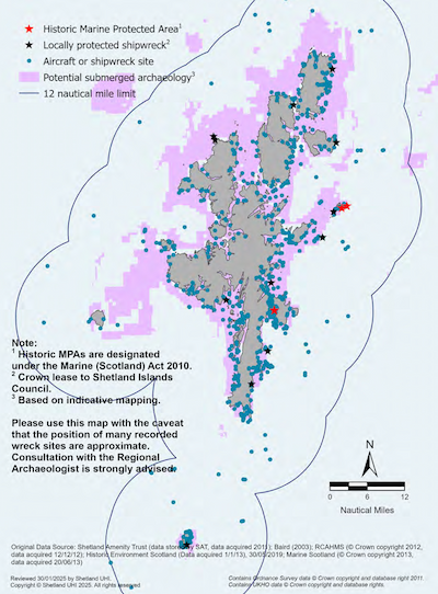
Within the Shetland Islands Marine Region there are around 1,490 known shipwrecks on the seabed, however, only a small proportion are known in detail. The National Register of Historic Vessels (NRHV) provides an overview of the UK’s surviving historic vessels. To help preserve shipwreck sites, the seabed around fourteen wrecks is leased by the Shetland Islands Council as a means of protecting the resources within them.
The seabed is also of paleo-environmental interest, particularly areas that were once dry land during ice age conditions and where there is potential for a wide range of buried deposits of archaeological interest e.g., Bressay Sound (Lerwick).
All items of ‘wreck’ recovered from an area must, by law, be reported to the Receiver of Wreck, Maritime and Coastguard Agency (MCA).[27]
Historic Marine Protected Areas (HMPAs)
Under Section 67 of the Marine (Scotland) Act 2010, Scottish Ministers may designate HMPAs to protect marine historic assets of national importance within Scottish territorial waters. This designation, designed to align with Scotland’s marine planning system, replaced the use of section 1 of the Protection of Wrecks Act 1973 in Scotland. Within the Shetland Islands Marine Region, three wrecks are designated within Historic Marine Protected Area.
Historic Environment Scotland (HES)
Historic Environment Scotland (HES) is Scotland’s lead public body for the historic environment. HES advises Scottish Ministers on Historic Marine Protected Area (HMPA) designation and regulation and will consult planning authorities on HMPA designation proposals within their area. HES is also the regulator for Scheduled Monument Consent. Their decision-making is directed by the Historic Environment Policy for Scotland and their Scheduled Monument Consents Policy. Scheduled Monument Consent (SMC) is required where activities or works would have a direct impact on Scheduled Monuments. In the event of damage to a Scheduled Monument, appropriate action is enforced by Historic Environment Scotland and/or Northern Constabulary.
Policy MP HIS1: Historic Marine Protected Areas
Proposals for marine development and use should consider potential impacts on Historic MPAs and the objectives of the designated site.
Where proposals are within or adjacent to the boundaries of any Historic MPA and there are predicted significant effects, the applicant will be required to demonstrate, to the satisfaction of the consenting authority with advice from Historic Environment Scotland:
- a) that the applicant has considered the preservation objectives of the designated site and there will be no adverse direct or indirect effects on the objectives of the Historic MPA;
- b) an assessment of the likely impacts of the proposal on hydrodynamic processes and seabed biology/water chemistry over the protected area; and, where appropriate, an archaeological mitigation strategy to minimise any potential impacts.
Applicants may be required to arrange for appropriate archaeological investigation, at their own expense to take place prior to the commencement of work, in consultation with the local planning authority (and the Regional Archaeology Service) and Historic Environment Scotland, where appropriate.
Policy MP HIS2: Safeguarding Nationally Important Heritage Assets
Proposals for marine development and use should protect and, where appropriate, enhance nationally important heritage assets so far as is consistent with the exercise of functions relating to the proposed development or use.
Proposals must not result in direct or significant adverse impacts on scheduled monuments or their setting unless exceptional circumstances have been demonstrated and impacts on the monument, or its setting, have been minimised.
For all other nationally important heritage assets, where detrimental impact on the heritage asset and/or its setting is demonstrated to be justified and unavoidable, suitable mitigating actions should be identified by the applicant in agreement with the relevant regulator and advisors.
If archaeological discoveries are made during marine development and use, there may be a requirement for a professional archaeologist to be granted access to inspect and record them.
Policy MP HIS3: Safeguarding Locally Important Heritage Assets
All other archaeological resources should be preserved in situ wherever feasible. Where preservation in situ is not possible, applicants should consider the need for appropriate archaeological excavation, recording, analysis, publication and archiving in advance of and/or during development.
Where proposals for marine development are within the vicinity of heritage assets, applicants should consider how the proposal design respects the original structure in terms of design, scale and, where appropriate, setting.
Justification and Considerations
Coastal archaeology is shown in Map 27. Submerged archaeology and Historic MPAs are shown in Map 28.
The aim of these policies is to provide protection for maritime heritage in accordance with current guidance and legislation. Marine archaeology makes a significant contribution to the character and amenity of Shetland. It is a valuable resource that can stimulate enjoyment of the wider environment and act as an important medium for education, recreation and tourism.
In the case of planning permission and works licence applications to the Shetland Islands Council, there may be a requirement for a professional archaeologist to be granted access to a site where archaeological discoveries are made for the purpose of inspecting and recording them.
It is strongly advised that applicants consult with the Shetland Islands Council’s Regional Archaeology Service at the pre-application stage and have regard to the SIC LDP and Historic Environment Policy for Scotland (HEPS).
Planning authorities must take HMPAs into account when exercising their functions and take advice from HES. This duty covers functions such as the preparation of development plans or consideration of planning applications for works that are capable of significantly affecting the preservation objectives for an HMPA.
Key Consultees
- Historic Environment Scotland
- Shetland Islands Council - Regional Archaeology Service
Further Information
- Shetland Islands Council – Local Development Plan
- UHI Shetland – Shetland Islands Marine Region State of the Environment Assessment
- Scottish Government – Scotland’s National Marine Plan
- Scottish Government – Planning Advice Note 2/2011: Planning and Archaeology
- Scottish Government – National Planning Framework 4
- Scottish Government – Our Past, Our Future: The Strategy for Scotland’s Historic Environment 2023-2028
- Scottish Government – Historic MPAs
- Historic Environment Scotland – Marine Heritage
- Historic Environment Scotland – Scotland’s Historic Marine Protected Areas
- Historic Environment Scotland – Scotland’s Scheduled Monuments
- Historic Environment Policy for Scotland (HEPS)
- PastMap
People and Place- Communities
Quality of Life for Communities
The marine environment not only provides economic benefits but can also directly contribute to the quality of life and well-being of coastal communities. This is recognised in The National Plan for Scotland’s Islands which provides a framework for action in order to meaningfully improve outcomes for island communities. The plan highlights the contribution of the aquaculture and fishing industries to sustainable economic growth in rural and island communities. It also sets out the importance and value of coastal, marine, and inland ecosystem assets. The SIRMP will enhance these benefits by safeguarding equitable access for those who want to use and enjoy the coast and seas, and their wide range of resources and assets.
The Shetland community has a long affinity and connection with the coast and marine environment. It is a valuable asset not only fulfilling a provisioning and regulating role but also a cultural and spiritual one. The non-material benefits people obtain from ecosystems include spiritual enrichment, cognitive development, reflection, recreation and aesthetic experience e.g., knowledge systems, social relations and aesthetic values. While these intangible benefits are difficult to evaluate, the social impacts of any development are a key consideration in any decision-making process.
Policy MP COM1: Community Considerations
Proposals for marine development and use should consider the social impact on the local community.
Where adverse social impacts may occur, applicants should consider:
- a) alternative locations for the proposed type of development and/or use;
- b) identifying necessary mitigation measures;
- c) engagement with local stakeholders, community councils, groups and other marine and coastal users;
- d) detailing how impacts have been assessed and considered in a manner proportionate to the scale of the development; and
- e) how the proposal aligns with local economic priorities and contributes to local or regional community wealth building strategies.
Justification and Considerations
The purpose of this policy is to help the local communities of Shetland achieve their full potential on a long-term, sustainable basis.
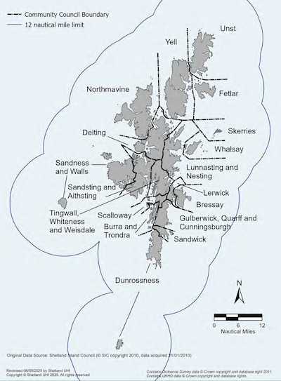
Community councils are the most local tier of statutory representation in Scotland. Their primary purpose is to ascertain and express the views of the community to the local authority and other public bodies. There is a statutory requirement for local authorities to consult with them on planning applications. Community council areas are shown in Map 29.
Marine development and use can have social implications for the local community. Social impacts can be diverse and complex in their nature but are most likely to be felt by individuals, families, or groups at a local rather than regional or national level. Proposals which incorporate community wealth building strategies such as, improving community resilience and reducing inequalities; increasing spending within communities; ensuring the use of local supply chains and services; and local job creation, can help reduce social impacts.[28]
Proposals for marine development and use can restrict the choices available to users for safe and accessible recreation locations. Proposals therefore have the potential to affect the well-being of individuals and groups who value their use of the marine environment as integral to their ‘way of life’ and social identity.
Certain development and use may also cause equity issues within local communities if some stakeholder groups feel marginalised in favour of other groups. For example, some locations may be of greater importance to those with restricted mobility (e.g., Eshaness, Sumburgh Head), families or young people.
The ability and/or willingness of local communities to absorb these impacts can, and does, directly affect the success or failure of marine developments or activities. Understanding what people value about their living environment, and why they care about a particular place or region, can lead to a deeper understanding of potential conflicts that might be mitigated if addressed at an early stage of any development proposal.
In addition, under national legislation for marine licensing,[29] a public pre-application consultation will be required for certain large-scale licensable marine activities with potential for significant impacts. Large-scale proposals for marine licences are those developments and activities listed under the Marine Licensing (Pre-application Consultation) (Scotland) Regulations 2013. Pre-application consultation with communities is also a requirement for major planning applications for fish farm developments under the Town and Country Planning (Development Management Procedure) Regulations 2013[30]. Pre-application consultation enables local communities and other interested parties to comment on and help shape proposals prior to their submission to consenting authorities.
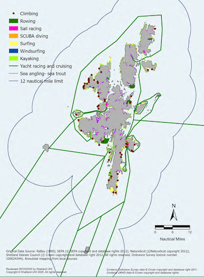
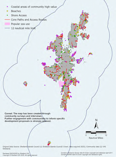
Marine Recreation
The sea around Shetland provides a variety of sporting and recreational opportunities. These include swimming, sailing, rowing, coasteering, recreational snorkelling and SCUBA diving, sea angling, kayaking, canoeing, windsurfing and surfing, as well as exploration of underwater and coastal heritage assets. Coastal recreation activities include walking and hiking, cycling, climbing, visiting heritage assets and wildlife watching. The coast also provides inspiration for a range of artistic and cultural activities.
Policy MP REC1: Safeguarding Marine Recreation
Proposals for marine development and use should consider potential impacts on marine recreation, including how the proposal could safeguard marine recreation by avoiding or mitigating the reduction or loss of amenity.
Proposals should consider how continued access rights to the marine and coastal resource for recreational use can be maintained, with any necessary changes to land access to be determined through the planning process. Opportunities for co-existence should be fully considered.
Justification and Considerations
Marine recreation areas are shown in Map 30 and Map 31.
Marine recreational activities support and enhance the local community through social integration, improving quality of life, and providing benefits to physical and mental well-being. These activities will be enhanced by a well-managed and healthy marine environment, attractive and well-maintained beaches and seashore, and good water quality. It should be noted that marine recreation and associated facilities are also an economic asset, and these policies should be considered in conjunction with Policy MP TR1 for tourism and leisure development or use. In addition, some localities, such as Lerwick and Scalloway harbours, and marinas, act as recreational hubs, providing marine access to the wider sea area.
Where there are land-based elements to development proposals these should have regard to the Shetland Outdoor Access Strategy and Shetland Islands Council’s Local Development Plan policies on open space and access.
Key Consultees
- Community Councils
- Visit Shetland
- Visit Scotland
Further Information
- UHI Shetland – Shetland Islands Marine Region State of the Environment Assessment
- Scottish Government – Community Councils
- Scottish Government – The National Plan for Scotland’s Islands
- Scottish Government – Scotland’s National Marine Plan
- Scottish Government – National Planning Framework 4
- Shetland Island’s Council – Local Development Plan
- Shetland Islands Council – Community Councils
- Shetland Cycling Routes
- Shetland Marinas
- Shetland Walks
- Shetland Islands Council – Shetland Countryside Access Strategy