Place-based policy approaches to population challenges: Lessons for Scotland
This report by the independent Expert Advisory Group on Migration and Population analyses a range of place-based policy approaches to population challenges (including zonal approaches), and sets out lessons for Scotland.
3. Approaches to Spatial Targeting
In this section we present two contrasting approaches to spatial targeting of policy to address negative population trends. As suggested in Section 1.2 these two approaches to targeting roughly correspond with two periods in the evolution of rural/regional policy paradigms, and two, roughly parallel ‘fashions’ in applied research.
During most of the period in which this evolution took place the UK was a member of the EU, and although policy here (especially in Scotland) has enduring distinctive features, it has not been unaffected by the European ‘zeitgeist’. This influence was clearest in the context of the Second (rural development) Pillar of the Common Agricultural Policy and in the implementation of European Structural Funds.
In broad terms the initial phase of this evolution was characterised by a strong emphasis upon economic competitiveness, driven by innovation and entrepreneurship, and evidenced mainly in terms of job creation and economic growth (defined in terms of GDP). This approach was exemplified by the 2000-2010 Lisbon Strategy. During this period, in terms of research and evaluation methods, the policy community was much influenced by neo-classical economics, supported in targeting, monitoring and evaluation by quantitative indicators.
Roughly since the 2008 economic crisis there has been greater recognition of a more holistic ‘place-based’ view of rural/regional development, allowing a stronger emphasis on well-being and inclusion, through maximising the potential of all forms of ‘territorial capital’ (including human, social and environmental). A key turning point was the publication of Fabrizio Barca’s “Agenda for a Reformed Cohesion Policy” in 2009. This ‘post-Lisbon’ period has been associated with a greater respect for qualitative analysis, and a more holistic, ‘narrative’ view of the countryside, emphasising diversity (of characteristics and performance) and specificity. It has also seen a more muted emphasis upon quantitative indicators, typologies, and ‘hard lines on maps’, in favour of a less precise, but more holistic, interest in ‘places’ and communities.
The two examples of targeting methodologies which we describe below represent these contrasting approaches; the first being ‘objective’ and quantitative, the second being more flexible and holistic, emphasising local diversity and the importance of development pathways. These are not offered as a basis for policy decisions (such as the choice of particular areas), but as demonstrations of alternative methodologies. However, it is important to keep in mind the associations which each of these carries in terms of overall policy paradigms. A mismatch between targeting approach on the one hand, and the broad policy goal and intervention logic, on the other, seems likely to raise unnecessary challenges in implementation. In particular, due to limitations in available data, the use of ‘hard’ boundaries based on statistical analysis may be unnecessarily restrictive or even counterproductive if applied to a holistic, community approach to development. The latter emphasizes unique local characteristics and potentials, which are difficult to tie down in precise locational terms.
3.1 Deriving objective indicators of shrinkage from the small area population estimates
We begin by considering the potential of the small area population estimate data as a basis of objective indicators of geographical patterns of population change, which may in turn provide a robust and quantitative means of targeting policy.
From the outset it is important to acknowledge the existence of a phenomenon which always constrains such analysis. Referred to by geographers as the ‘MAUP’ (modifiable areal unit problem), this is the simple fact that when analysing geographical patterns (such as population change) the size and configuration of the spatial units are extremely important. Aggregating phenomena which are located at points to larger or smaller areas, and changing the boundaries, can change the ‘picture’ revealed in the map, and consequently the interpretation of the process behind it, or the policy based upon it. This is the phenomenon exploited by Gerrymandering. We already pointed out that maps of population change at data-zone level, presented in the 2021 EAG report, revealed a highly fragmented pattern, which is summarised in the Scottish Government’s Population Strategy document as a broad drift from east to west. These two observations are not contradictory, they are a consequence of different levels of generalisation.
There is arguably merit in using the (geographically) most detailed data available, in this case the SAPE. However, the fragmented nature of the pattern makes the identification of target zones for policy by applying a simple threshold to individual data-zones, problematic. Furthermore, as discussed in sections 1 and 2, we accept;
This suggests a need for policy ‘zones’ which encompass the ‘hotspots’ of population shrinking, but also reflect, as far as is feasible, the ‘activity spaces’ of the residents within the target data-zones.
A widely accepted definition of ‘shrinking’, devised by Grasland et al, states that “a region that is ‘shrinking’ is a region that is losing a significant proportion of its population over a period greater than or equal to one generation” (Grasland et al 2008). There are thus two ways in which ‘shrinking’ as an embedded and sustained process can be distinguished from other random fluctuations: (i) duration, and (ii) intensity. Both of these were already specified in the analysis presented in the EAG’s 2021 report. In the case of duration, the peak year for each data-zone was identified. The number of years since that peak is a good indicator of duration. We also calculated (and mapped) the average annual percentage population change since the peak year, as an indicator of intensity.
The precise thresholds of duration and intensity which may define shrinking data-zones are of course a matter of judgement. The illustrative analysis below uses thresholds which seem reasonable, but we offer no specific scientific justification for them. Our intention is not to identify specific target zones for policy, but rather to demonstrate the strengths and weaknesses associated with a replicable and evidence-based selection procedure, based upon available SAPE data, but also informed both by our understanding of complex shrinking, and the associated policy requirements.
Figure 2 shows the distribution of data-zones across the urban-rural types (2020 urban-rural classification applied to data zone data for all years), with durations of decline of 5, 10 and 15 years, between 2001 and 2020.[10] Growing data-zones exhibited their peak in 2020. The bar at the extreme right-hand side of the graph shows the distribution of duration across all 6,976 data-zones in Scotland. Perhaps surprisingly, more than half of these (54%) have been shrinking for more than 10 years. A further 17% have shrunk over the past 5-9 years, and the same proportion for less than 5 years. In just 12% of data-zones the peak year was 2020, or in other words the population is growing.
Taking the urban and rural categories separately, and focusing particularly on the rural and small town data-zones, the graph shows that small towns generally have a longer duration of shrinking than rural areas, and that population decline has been going on longer in very remote small towns and remote/very remote rural areas. The smallest share of data-zones which have lost population for more than a decade is in the accessible rural category.
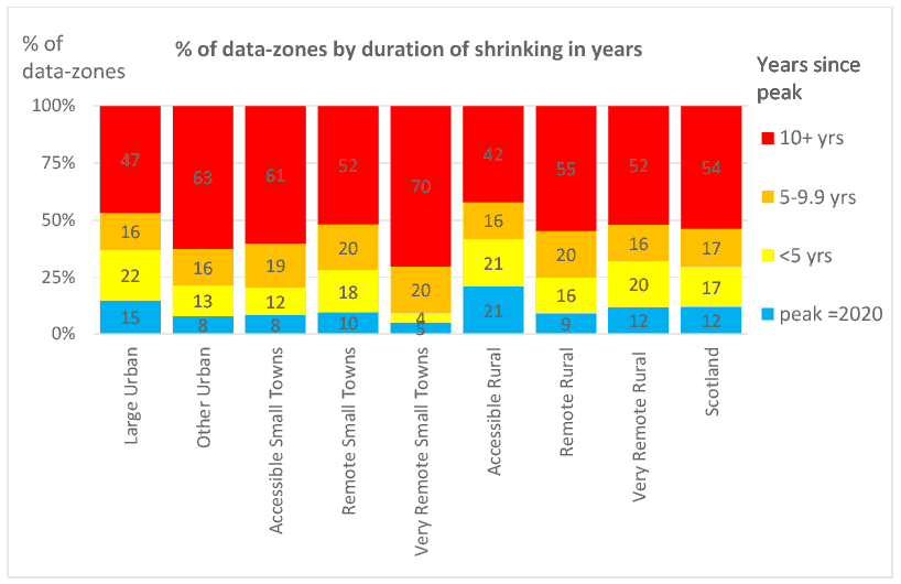
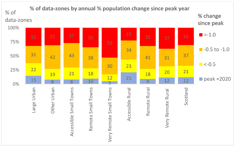
Figure 3 presents a similar analysis of the intensity of shrinking, expressed as the share of data-zones in which the average per annum percentage loss of population was more than 1%, between 1% and 0.5%, and less than 0.5%. Across Scotland as a whole, just over 30% of data-zones experience the most intense shrinking (>1% per annum), whilst 12% were growing. In the very remote small towns, the share with most intense population decline rose to 53%, and the share which were growing fell to 5%. At the other extreme only 23% of accessible rural data-zones exhibited population decline at more than 1% per annum, and 21% were growing.
For the purpose of illustrating how such data may be used to identify a set of data-zones most affected by sustained population decline we can combine the duration and intensity criteria. We propose that a shrinking data-zone is one which has been shrinking for more than 10 years, at a rate of at least 1% per annum. Figure 4 shows these two criteria applied to all data-zones in Scotland. Figure 5 shows the distribution of ‘shrinking’ data-zones (those which satisfy both criteria) across Scotland.
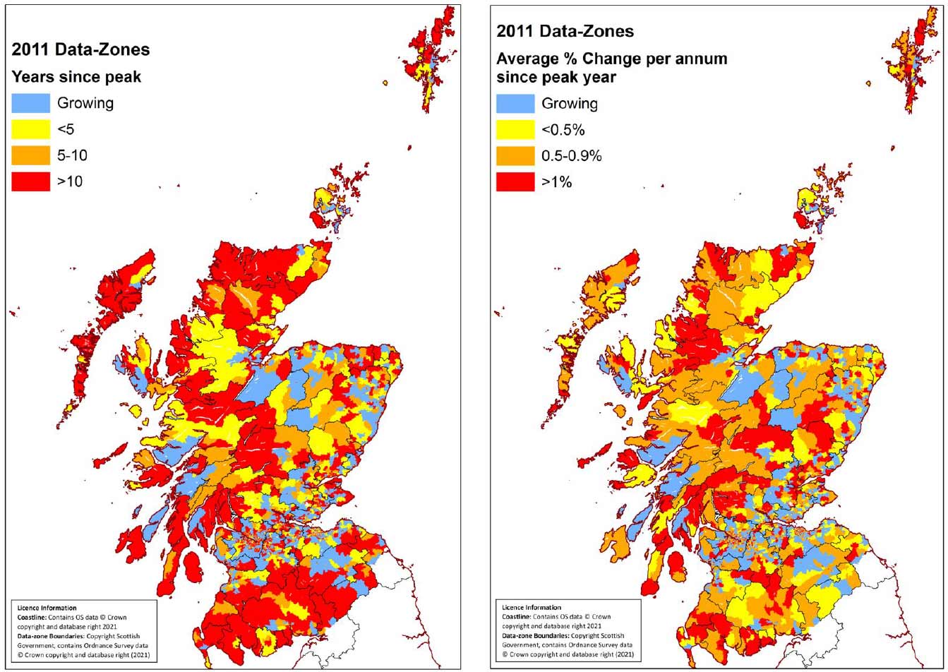
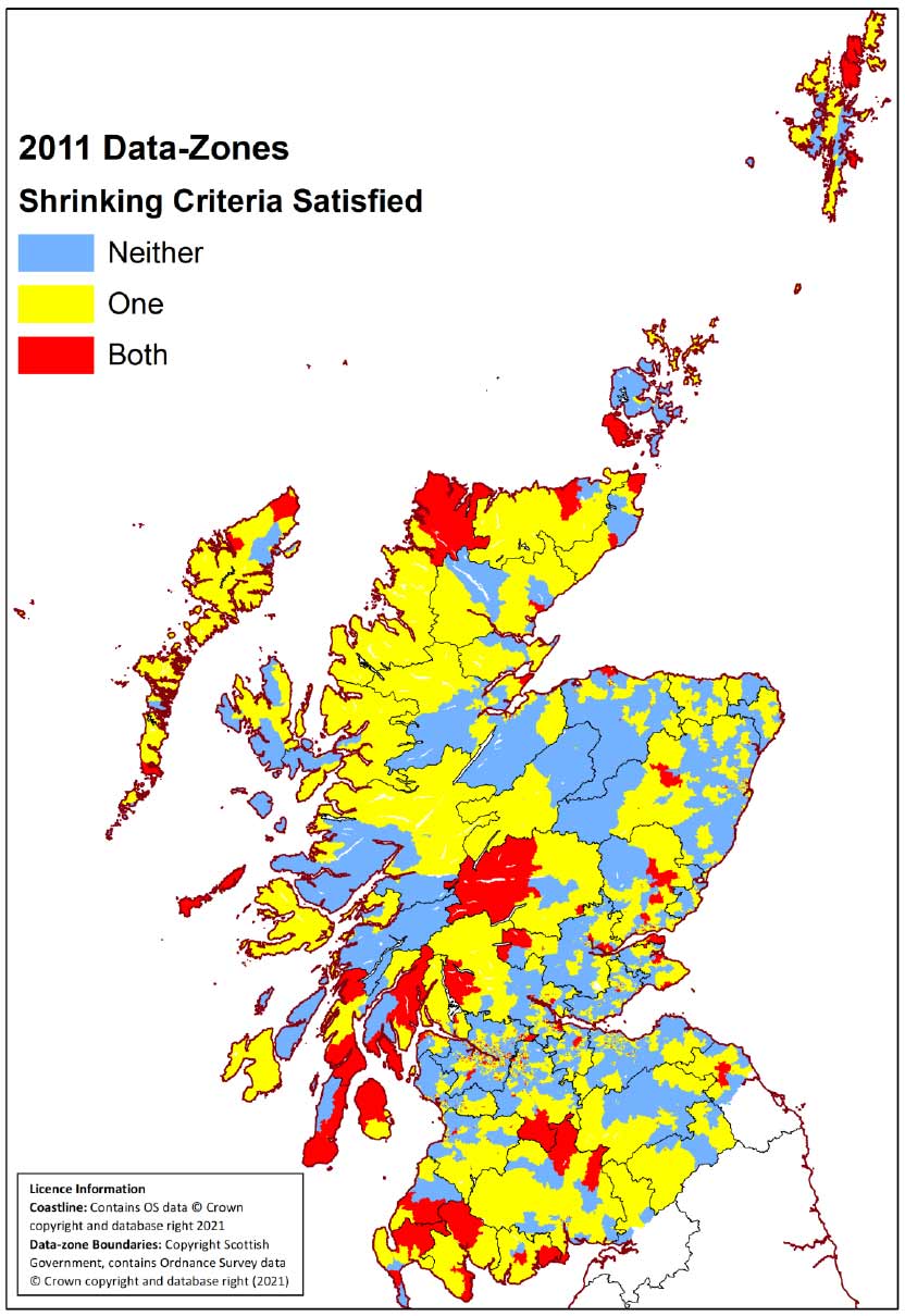
Table 2 shows how many data-zones in each urban-rural category satisfy these criteria, and the population in each category.
| Data-zones | % | Population 2020 | % | |
|---|---|---|---|---|
| Large Urban | 271 | 10.9 | 178,130 | 8.6 |
| Other Urban | 390 | 15.9 | 245,965 | 13.3 |
| Accessible Small Towns | 78 | 12.7 | 44,439 | 9.4 |
| Remote Small Towns | 13 | 12.5 | 10,543 | 13.3 |
| Very Remote Small Towns | 30 | 30.6 | 21,775 | 33.5 |
| Accessible Rural | 80 | 9.9 | 37,614 | 5.7 |
| Remote Rural | 24 | 12.2 | 15,200 | 10.3 |
| Very Remote Rural | 38 | 18.6 | 24,339 | 16.1 |
| Scotland | 903 | 12.9 | 578,005 | 10.5 |
Once again, the very remote small-town category stands out as the most severely affected. More than 30% of its data-zones satisfy both duration and intensity criteria, and these data-zones contain more than one-third of the population of the remote small towns. At the other end of the spectrum, less than 10% of accessible rural data-zones, containing less than 6% of the population, satisfy the criteria.
Having established what appear to be reasonable criteria for designating data-zones as “shrinking” we may take a further step towards identifying potential policy target areas, by a simple process of calculating the share of data-zones, defined as shrinking (and the associated population share) within commonly used administrative areas. No distinction has been made between urban and rural data-zones in this procedure, although exclusion of urban areas is a potential refinement. For illustrative purposes we apply this procedure to the 32 Council Areas, and the 47 travel-to-work-areas (TTWA).[12]
From the tables presented in Annex 3 it is evident that Argyll and Bute, Inverclyde, West Dunbartonshire, Western Isles and East Ayrshire are the top 5 Council areas in terms of the proportion of data-zones, and population, which fulfil both duration and intensity criteria. In terms of TTWAs, Dunoon and Rothsay, Campbelltown, Greenock, Wick, Girvan, and Lochgilphead are in the top 5 (with a slightly different order for proportion of data-zones and percentage of population).
The choice of Council Areas and TTWAs is far from ideal. Council areas are, in many cases, too large, too heterogeneous in terms of local population trends, and settlement patterns, and do not represent activity spaces, labour market areas, or ‘functional areas’. As such they probably cannot be serious candidates for zonal population policies. TTWAs are of course intended to approximate to labour market areas, and are thus, in principle more suitable. As noted in our 2021 report, the current TTWAs are based upon an analysis of commuting patterns drawn from 2011 Census data. We assume that an update will follow the release of the 2022 Census. However, the TTWA concept is open to many questions in remote rural areas and small towns of Scotland, where the influence of urban labour markets is very weak, but small towns play an important role. The 2022 version of the TTWA should reflect, on the one hand, increased mobility during the past decade, and increased ‘home working’ and ‘multi-local living’, as a consequence of COVID-19, on the other. Further consideration should be given to the development of the concept of ‘functional rural areas’ in the Scottish context.
To reiterate, the above findings are not intended as a recommendation for selection of zones for repopulation policy. However, they provide an example of an objective methodology for selecting areas within which to target policy, which compares all parts of rural Scotland with consistent criteria. The benefits of using SAPE as an evidence base include ease of monitoring on an annual basis, with the potential to adjust the target area in response to ongoing shifts in population. Nevertheless, the selection of spatial units for aggregation requires additional consideration: TTWAs are an improvement on Council Areas, but they require updating, and careful handling of remote rural and small-town areas.
This approach lends itself to ‘horizontal’ national schemes with relatively simple forms of standard assistance, where eligibility is somehow defined by geographical characteristics, such as the (former) Less Favoured Areas scheme of the CAP. It is perhaps less appropriate for tailored place-based interventions which seek to address specific local challenges and mobilise unique community potentials.
An alternative to the approach described above, which can be criticised as being ‘mechanical’, and ‘monochrome’, would be to provide a more colourful ‘pen-picture’ of different parts of rural Scotland, integrating important contextual information, and an awareness of the legacy of past trends. This approach is not necessarily less quantitative but uses the statistical evidence in a more holistic way. It will be illustrated through examples of areas of rural Scotland which (arguably) might be the subject of a targeted repopulation strategy. Again, it is important to emphasise that these are illustrations of the approach, not policy recommendations.
As section 2.2 made clear, developments over the past forty years have increasingly changed the contexts within which policies might be developed to mitigate or reverse rural depopulation. Over most of rural Scotland, population decline has become much more localised and focused on quite limited spatial areas, its causes and possible mitigations are therefore diverse, and the boundaries of the most seriously affected localities do not match any of the standard administrative or statistical units.
Moreover, as shown in our discussion of ‘activity spaces’ in section 2.2.2, affected localities, their population trends and residents’ lives are situated within complex and dynamic linkages to other places. This has very significant implications for thinking about both the possibilities of new zonal population initiatives and the physical and social space to which any single policy action might apply. Focusing action within a single or a small cluster of data zones which meet one or more of a particular set of qualifying criteria may have at best only a limited effect. The diversity of outside influences in different places implies that any proposed zonal policy would need to have very flexible qualifying criteria. In what follows we offer some worked examples to illustrate this point.
At one extreme might be an island like Tiree, where the population in 1981 had been in almost continuous decline for more than 160 years. It then stabilised for two decades, then fell by 15 per cent by the 2011 census. Unfortunately, its estimate is now combined with Coll in a single datazone, but the estimated joint population fell by a further ten per cent to 2020. In addition, the age profile of the present population of the two islands, with just six per cent of the population aged 16-24 and 16 per cent aged 25-44 does not suggest much prospect of for any marked intrinsic population growth. On these bases Tiree would likely meet any ‘objective’ population decline criteria if these were used as the basis for spatial targeting.
Tiree alone might be considered too small to be a valid ‘zone’. However, in spite of its small size, its relative physical isolation with a minimum 3 hours 20 minutes journey by ferry to Oban would make it hard to integrate into a wider zonal initiative (except perhaps with Coll). Its small size and remoteness also make it less likely to be able to become, like Mull, a prime site for attracting large numbers of retirees – though its wildlife and world-famous surfing beaches might be attractive for younger in-migrants, but only if excellent broadband or wi-fi facilities were provided to support working from home. Currently, Tiree has a markedly smaller proportion of its employed population engaged in Accommodation and Food Services than any of the other large Argyll and Bute islands, suggesting much less ability to attract tourists, and its lack of sheltered port facilities, and the difficulty of providing any, might be a further challenge for the establishment of major engineering or industrial activity on the island. It is not immediately clear how, if at all, Tiree’s significant population decline could be reversed by a zonal approach - certainly it would need to be sui generis with interventions carefully tailored to the island’s characteristics, (natural) resources and potential.
By contrast, Bute developed initially as a high-class holiday and upper-middle class second home and even commuting centre, and later as a mass holiday and day trip centre from Glasgow. Bute’s population seems to have been on a steadily rising trend for most decades from the middle of the nineteenth century through to 1951 (the resident population figures for Bute, as elsewhere, are uncertain before 1981 because the censuses recorded persons present not persons resident, and parishes with many year-round holiday and second-home owners have figures variably inflated as a result). This was followed by a fall which was probably of nearly two fifths to 1981, as its attractiveness as a mass tourist destination steadily declined. Thereafter, for two decades, there was almost no change. Since 2001, however, both the town of Rothesay, which holds more than 70 per cent of the roughly 6,000 estimated population, and the rural rest of Bute, have each lost 17-20 per cent of their population, though the decline may have slowed in recent years. These long periods of stagnation and decline, plus the attractiveness of many parts of the island as a retirement destination, have left both the rural areas (where 37 per cent are aged 65 and over) and many parts of Rothesay, with very skewed age profiles. As a result, there is very little prospect of major intrinsic demographic recovery. Equally, Bute’s geographical situation, its now slightly gentrified commercial and tourist environment, and its growing attractiveness to weekend commuters, mean that any successful new policy actions would seem most appropriately to be tailored specifically to the island itself. Finally, the internal and external transport and commercial links between Rothesay and the rural rest of the island, mean that any new zonal policy would need to contain provisions for both rural and urban areas.
Boundary issues, and especially the issue of whether towns would be included in any ‘rural’ population initiative would also arise in any zone-based proposal for Lewis and Harris. There has for many decades been a fluctuating slow decline in population in all the civil parishes outside Stornoway - which has itself remained largely constant, with a declining town centre offset by a steady expansion of new housebuilding in its immediate peripheries. Stornoway is the key administrative, trading, and infrastructure centre of the island(s), with two major supermarkets, the only secondary school, the airport and local government offices. It therefore attracts substantial inward commuting from the surrounding areas. In more distant parishes access to affordable housing, and concerns regarding commuting times to Stornoway for work and schools seem likely to play a role in retaining and/or attracting population. Under these circumstances any policy to encourage population retention or growth in the rural parishes of Lewis and Harris would need to consider transport speed and local housing requirements in a whole-island way, perhaps even by taking some focus away from Stornoway.
Islands are in some ways different from the rest of Scotland because they each have a clear physical boundary. Elsewhere the problems of boundaries are much bigger. It is clear from the experience of Special Development Areas discussed in Section 4.1 below that boundary drawing was a major source of discontent among areas that were just excluded by a boundary, and that it was also alleged that areas just outside a boundary could be damaged by new developments being channelled away from them into the zone. In particular, for present purposes, questions would arise as to whether towns within or on the edge of a proposed ‘zone’ should be included in or excluded from any scheme.
A possible zonal scheme for Galloway would illustrate some of these issues well. Between 1961 and 1991, the population in the County of Wigtown declined by 6 per cent. This broad figure was nuanced at a more local level however: the population in fact increased by 8 per cent in the three parishes in which Stranraer was located, and by 15 per cent in Pennighame (which contained most of town of Newton Stewart). By contrast, there was a 21 per cent fall in the remaining more rural areas where numbers fell in every parish, with the largest falls (of over 25 per cent) in some of the most remote among them. The legacy of this sustained decline is still clearly present in the highly skewed age structures of almost all the rural parishes in the area. Thereafter, the censuses to 2011 show further declines in most of the rural parishes, approaching 30 per cent in the two parishes at the far south of the Machars and over 60 per cent in one of the hill parishes to the north. Stranraer also began a slow population decline in the same period.
The most recent ten-year period shows much more contrasting patterns. The population of most of the Machars area south and west of Newton Stewart has continued to fall, with the largest falls, of more than 10 per cent, in the most southerly and remote data zones. Meanwhile, another set of big recent declines have run across the whole span of sparsely populated hill country, from the eastern shore of Loch Ryan, north of Newton Stewart and deeply into what was northern Kirkcudbrightshire. By contrast, further west, the population of the part of the Rhins south of Stranraer and down to the Mull of Galloway has recently been growing (though its age profile strongly suggests not by natural increase), and there have only been rather small declines north of Stranraer up to the western mouth of Loch Ryan.
In the town of Newton Stewart, the population of about 4,000, has grown by more than ten per cent over the past twenty years (with just a small fall in the past decade), but Stranraer, by far the biggest town, with a population of nearly 10,000 experienced a twenty-year decline of about 6.5 per cent and a more recent ten-year decline of 4.3 per cent. However, across the area as a whole the 2011 census travel to work data suggest that what has been happening in the most remote rural areas is not significantly linked to changing employment opportunities or prosperity of these towns, and the road network has minimal east-west connections across the hill parishes.
Thus, whilst in the 1990s, and possibly even in the following decade, a case could quite easily have been made for special ‘zonal’ treatment for the whole of rural Wigtownshire on the grounds population change criteria, it would be much more difficult to do so now. A more selective zonal approach focused only on those localities still experiencing quite rapid decline however, would require careful consideration of what might be the impact on their more stable or even growing neighbours? Moreover, any spatially-targeted policy interventions would need to examine what the linkages between different places within the area are and how they influence such a complex picture of population change.
Contact
Email: population@gov.scot