Place-based policy approaches to population challenges: Lessons for Scotland
This report by the independent Expert Advisory Group on Migration and Population analyses a range of place-based policy approaches to population challenges (including zonal approaches), and sets out lessons for Scotland.
2. Patterns of population change: a justification for local ‘repopulation’ initiatives?
In this section we describe the pattern of population change across Scotland, and the particular features within rural Scotland which have prompted the COHI RZ initiative and inform the Scottish Government’s Population Strategy. We begin by reviewing key findings on rural depopulation from our previous reports, followed by a brief update, and then explore an alternative ‘narrative’ perspective which allows a greater recognition of the importance of unique geographical contexts and past development pathways. The latter opens up a means to explore issues relating to the ‘behavioural arenas’, which may be ideal candidates for the spatial units of place-based repopulation policy.
Of the six EAG publications to date, the two which have most to say about rural population trends were the first report (February 2019) “UK Immigration Policy after Leaving the EU Impacts on Scotland’s Economy, Population and Society”, and the 2021 report: “Designing a Pilot Remote and Rural Migration Scheme for Scotland: Analysis and Policy Options”. The key findings were:
- That rural Scotland exhibits a range of recent population trends, so that generalisations based upon a simple urban-rural dichotomy are unhelpful. Indeed, even the most detailed (8-fold) urban-rural classification inevitably masks considerable local variation.
- Analysis of Small Area Population Estimate (SAPE) data, filtered through the Scottish Government’s 2016 Urban-Rural classification, showed that the population of accessible rural areas, within commuting distance of the Central Belt, other large cities and major towns, has tended to grow continuously, at rates above the Scottish average, since the turn of the century. Additional analysis, distinguishing Sparsely Populated Areas (SPA) showed that data-zones close to relatively small and remote towns, such as Stornoway, have also experienced population growth.
- Remote rural areas also (on average) saw growth until the late ‘noughties’ but have since experienced population decline. The most remote and sparsely populated areas have seen the most substantial decline.
- The populations of accessible, remote and very remote small towns have shown very similar trends to their rural counterparts, though less extreme, i.e. closer to the Scottish average. Thus, both remoteness and settlement structure seem to play a role in determining recent population trends.
- The relatively consistent and coherent trends revealed by this analysis nevertheless belie a very fragmented geographical pattern when mapped at a data-zone level.
- Analysis of the components of population change suggests that the process by which the remote rural areas have ‘lost’ population in recent years is predominantly through natural decrease (more deaths than births) rather than through out-migration.
- This natural decrease is a consequence of age structure, which is partly a legacy of past out-migration, partly a consequence of current out-migration being age-selective, and partly due to in-migration of retirees.
- As a consequence of these complex age structure and migration dynamics remote rural areas have evolved an increasingly unbalanced age structure, with proportions of children and working age adults below the Scottish average, and an expanding pensioner population.
- By comparison, the situation in accessible rural areas is mixed: The share of population which are children is above the Scottish average, but so is that of the over-65s, whilst the share in the economically active age groups is below the Scottish average.
- In accessible small towns the age profile is similar to the adjacent accessible rural areas, but closer to the Scottish average.
In very broad terms the analysis suggests that the past ten years have seen, on the one hand, in remote rural areas, continued decline and ageing of population, and on the other, in accessible rural areas, increase, and a more balanced age structure. However, it is important not to overlook the signs that, within the remote rural areas there is a tendency for population to drift towards (but often not into) small towns and villages. When viewed through the prism of more aggregated (i.e., Council Area) data these local dynamics resolve into the East-West contrast described in the 2021 Population Strategy (Scottish Government 2021). Such generalisations, either in terms of ‘types of rural’ (which, by their nature, cut across economic functional geography) or broad regions of the country, of course mask a rich tapestry of specific local experiences and narratives. These are discussed in more detail in Section 2.2 and Section 3 below and it will become clear that spatially targeted interventions to address population trends need to engage with this level of complexity.
2.1 Updated urban-rural analysis 2011-2021
Figure 1 below is an updated version of graphs which appeared in the EAG’s 2021 report “Designing a Pilot Remote and Rural Migration Scheme for Scotland: Analysis and Policy Options”. Two things have changed since that report was compiled: (i) the Scottish Government’s urban-rural classification has been updated and (ii) small area (data-zone) population estimates (SAPE) have been published for 2021.
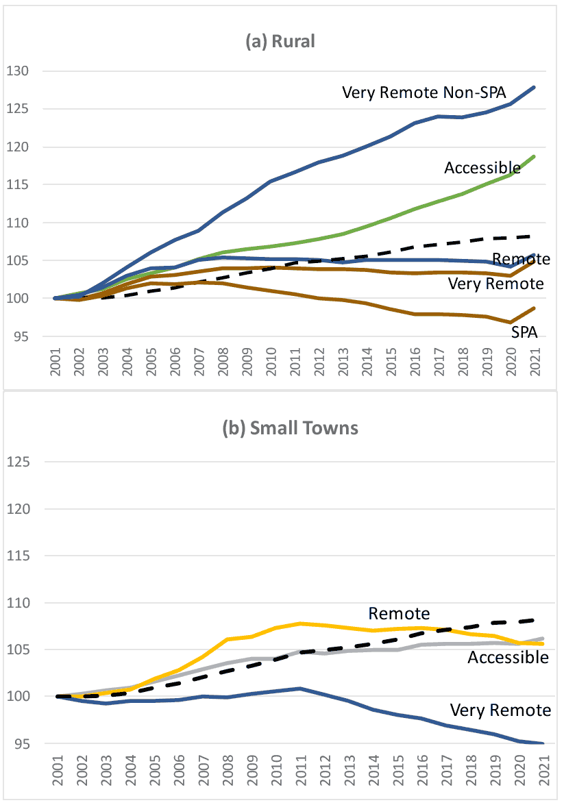
(Source: National Records of Scotland: Small Area Population Estimates)[7]
The 2020 urban-rural classification reflects both changes in settlement populations (some towns move across the 3,000 and 10,000 person thresholds which define “small towns” and “other urban” areas) and software changes in respect to the mapping of the travel-times which define remote and very remote areas. As a consequence of these changes a number of data-zones have been reclassified. These changes are detailed in Annex 1.
Despite these reclassification effects, when the new classification is applied to the data-zone population estimates for the period from 2001 to 2020 (Figure 1) the basic profile of (pre-2021) change, and the relationships between rural and small-town areas, remains very similar to that identified in our previous report.
The 2021 SAPE figures, and in particular the uptick in population in remote and very remote rural areas, reflect the (potentially temporary) effects of the COVID-19 pandemic. These are explored to a limited extent in Annex 2. However, in the absence of additional evidence, it is risky to speculate about the exact nature of the changes, and the extent to which they are affected by the SAPE’s use of Community Health Index data as an indicator of migration. The 2022 Census data will shed further light on this. Meantime, since the objective of this section of the report is to provide context for the discussion of zonal repopulation policies, our focus will be upon pre-COVID-19 trends.
Presenting the (pre COVID-19) trends in SAPE by urban-rural type highlights the fact that the categories of data-zones which are, on average, most severely affected by negative population trends are in the ‘sparsely populated areas’ (SPA), the very remote rural areas, and the very remote small towns (EAG 2021). Least affected are the accessible rural areas. Of course, as the maps in Annex 3, and in our 2021 report, show, there is a significant degree of heterogeneity within each of the urban-rural types. However, few would dispute that, broadly speaking, the pockets of depopulation which are the legitimate subject of targeted [rural] policy tend to be in the more remote and sparsely populated parts of Scotland. Very remote small towns stand out as facing particular challenges.
Bearing in mind the arguments presented in Section 1 regarding the need for policy responses to address wider social and economic processes of decline (complex shrinking), which are not confined to these pockets of decline, but occupy more extensive ‘functional areas’, it will be helpful now to turn to a different perspective, which emphasises the local geographical contexts, and unique historical development paths, of depopulating localities.
2.2 Patterns of change within wider historical and geographical context
Much recent work on population change in Scotland, as in many other countries, has stressed the importance of placing local developments within both their wider historical and geographical contexts. Past demographic events and their duration can have significant and long-persisting impacts on population age structures in ways which affect not only current social needs but also future patterns of fertility and mortality and possibilities for intrinsic population recovery. Both the demographic and the social impacts of local rural population declines are likely to be different if they are occurring within a wider area of similar population change (especially if this also includes their local urban service centres), as opposed to being relatively isolated clumps within an otherwise stable or even growing population context. Any policies developed to mitigate or reverse population decline in particular places need to understand and take account of both these contextual factors.
2.2.1 Situating population change historically
As noted in Section 1, population numbers and settlement patterns are dynamic and evolving, perhaps all the more so in today’s digital and global world. In twentieth century Scotland, after four decades of slow growth, the population began to decline in the later 1970s and continued to fall until the end of the century, largely as a result of high levels of net emigration. Since then, between 2001 and 2020, the estimated national population has grown by nearly eight per cent. ( Note that, throughout this Report, we have used 2020 rather than 2021 as our most recent data point, because it is as yet unclear whether a new pattern of change has begun in the latest estimates, or whether the data for 2021 will prove anomalous in the longer term (see Annex 2)). Within these national figures however, changes have been very uneven. A comparison of local authority areas shows the highest levels of population growth between 1991 and 2020 in East Lothian (28 per cent), West Lothian (27 per cent), Aberdeenshire and Edinburgh (both over 20 per cent). These are followed in order, by Perth and Kinross, Midlothian, Stirling, Highland, Orkney, and Moray (National Records of Scotland, 2021).
Over the same period, by far the biggest and most consistent decline among Scotland’s local authorities has been in Inverclyde (more than 14,300 people, almost 16 per cent) with large and continuing falls along almost the whole Clyde coast from Port Glasgow, through Greenock and Gourock and beyond. Other largely urban local authorities with significant population declines include West Dunbartonshire (8.9 per cent), Dundee (4.3 per cent) though with significant recovery in more recent years, and North Ayrshire (2.8 per cent). So, it is important to remember that declining population is not confined only to rural areas.
Indeed, populations in many of Scotland’s more rural local authorities have grown in recent decades. However, Argyll and Bute, at almost any level of geography, stands out for its consistent decade-by-decade pattern of long-term losses. Taken as a whole, its estimated population loss in the period 1991-2020, was nearly 8,100 people (8.7 per cent). In percentage terms, this is lower than the loss of over 2,800 people in Na h-Eileanan Siar (9.6 per cent), but that decline was particularly concentrated in the 1991-2001 decade; since then, there have been smaller almost exactly counter-balancing rises and the falls, with a small total fall, estimated at 1.1 per cent, between 2000 and 2020. Dumfries and Galloway, where the population rose by 2.5 per cent between 2001 and 2011, is the only other mostly rural local authority to have seen an authority-wide decline (of minus 1.9 per cent) in the most recent decade. This new situation of growth even in most rural local authorities reflects a fundamental change in the patterning of local population growth and decline across Scotland. For the populations of pre-1975 county geographies, this is illustrated in Table 1, which looks at the percentage of mainland parishes which experienced inter-censal decline from the 1960s up to 2001-2011.
| 1961-1971 | 1971-1981 | 1981-1991 | 1991-2001 | 2001-2011 | Parishes N= | |
|---|---|---|---|---|---|---|
| Aberdeenshire | 82 | 41 | 55 | 31 | 17 | 83 |
| Argyll | 67 | 33 | 79 | 50 | 67 | 28 |
| Caithness | 70 | 60 | 30 | 50 | 30 | 10 |
| Inverness | 80 | 45 | 75 | 35 | 20 | 32 |
| Ross and Cromarty | 52 | 7 | 93 | 48 | 24 | 29 |
| Sutherland | 67 | 42 | 58 | 67 | 25 | 12 |
| Berwick | 91 | 69 | 50 | 44 | 28 | 32 |
| Dumfries | 84 | 73 | 30 | 57 | 30 | 44 |
| Kirkcudbright | 85 | 44 | 56 | 43 | 52 | 28 |
| Wigtown | 88 | 59 | 41 | 59 | 65 | 17 |
Prior to the census of 1971 most rural counties had experienced very widespread decade-by-decade population losses, driven above all by high rates of net out-migration, as they had had for most of the 19th century also. Beginning in the 1970s, a clear change began to occur and, from the 1990s, with the partial exception of large parts of Argyll and of Wigtown and some parts of Kirkcudbright, the former widespread general pattern of mainland rural parish decline became much more localised.
The situation on Scotland’s many islands has been similar to but slightly different from the mainland. Between 1861 and 2011, the total number of inhabited sea-bounded islands in Scottish waters fell by half to 88, 33 of which had fewer than fifty residents. The number of islands which experienced a significant decline in population between 2001-2011 was much fewer than had been the case in most previous decades. Of the 55 islands with 2011 populations of fifty or more, just 18 experienced any kind of decline in the 2000s, compared with 23 of them in the 1980s and 37 in the 1990s. Some, including Lewis and Harris, and Barra, experienced significant recovery in numbers. Among other notable cases, Mull continued its long-term population growth, boosted to a great extent by significant in-migration of retirees, many born in England, and also by the economic consequences of rising tourism linked especially to visitors to Iona. After a century of decline, Skye also expanded its population. Orkney and Shetland mainlands continued to benefit modestly from oil development, and several smaller islands of their groups saw continued recovery helped by linkages by causeway or bridge to larger neighbours.
But, even in this period of overall positive growth, there was also a significant number of islands where populations continued their long-term decline. Among the larger islands, Arran moved into population decline, and Bute continued to lose population as it had done for most of the previous half-century. Islay, and South and North Uists also saw continued falls, as did Tiree. Among the smaller islands, a particularly notable feature was the continued long-term decline (or at least minimal recovery) in many islands which were multiple-stop (with or without a change) ferry journeys away from mainland Scotland or, where relevant, from Shetland or Orkney Mainlands.
This brief overview demonstrates that when examined over a longer term and at varying geographical scales both demographic trends and the wider contextual factors affecting and affected by them are in fact dynamic and subject to change. Twenty-first century rural Scotland has a much smaller number of areas of declining populations when compared with even the quite recent past, and most of these are very far from towns and offer minimal locally-accessible employment opportunities. Understanding these historically shifting patterns of changes requires us to think about places as existing in a dynamic relationship with wider geographic contexts, as well as with social, cultural and economic developments.
2.2.2 Understanding change in relation to wider contexts
A principal driver of the changes to population discussed above has been significant net population inflows. Migration of EU nationals following the accession of A8 and A2 countries after 2004 has played an important role of course. However, contrary to an intervention logic based around economic growth, other important drivers are not directly related to new employment opportunities physically situated within the communities themselves. Instead, other socio-economic, demographic and cultural developments have underpinned much of the new in-migration. One, which is clearly documented by comparative analysis of population age structures and birthplaces in successive census figures, is in-migration of older people on retirement, or in preparation for it, for example, into Mull. A second, but difficult to estimate the precise extent of its growth until we have 2022 census figures, has been a continued increase in newcomers moving from urban areas in search of a ‘better life’. These moves have been stimulated most recently by better broadband connectivity, enabling more of those who wish to ‘work from home’.[9] A third and likely particularly significant factor has been a major increase in medium and even long-distance car-based commuting to urban areas (it is hoped the 2022 census will provide data to explore this trend in more thoroughly). A Highland Council study of commuting into Inverness, based on 2011 travel to work data, showed that less than 50 percent of those employed in the city actually had homes in Inverness, whilst just over 50 percent travelled to work there, coming from 88 per cent of all the ‘settlement zones’ in Highland. At least one in seven travelled more than 30 kilometres in each direction (Highland Council, 2015). From the opposite perspective in 2011, in more than one in eight of Scotland’s parishes, over 20 per cent of the working population travelled at least 30 thirty kilometres to work, and there were 14 parishes, mostly but not exclusively in remotest Highland, where at least 10 per cent travelled more than 60 kilometres (Census of Scotland, 2011, Parish Data).
This kind of growth in the amount of medium and even long-distance daily commuting to work is facilitated by significant developments in both physical transport and digital communications. This in turn allows many more people to choose where they live on the basis of life-style preferences and housing costs. An ageing population includes a growing number of people who are living on pensions which do not tie them to any particular locality, whilst high-speed internet working allows some people to work for employers far distant from their home location, at least most of the time.
The other side of this is that developments elsewhere can have a significant impact on localities some distance away from them. The attractiveness of living in an area can be affected significantly by the availability, opening or closing of businesses, retail or infrastructure services in places which may be some distance from their homes. The arrival of supermarkets in towns sometimes many miles away which nevertheless offer home shopping deliveries, can make it easier for people to live in remote areas, but may also undermine the viability of local shops. Closure of a major employer does not just impact on its immediate community. The Highland Council 2011 travel to work report cited above (Highland Council, 2015) found that almost a quarter of workers in Reay (the location for the Dounreay nuclear facilities) commuted more than thirty kilometres to their work. The impact of its rundown therefore spread over a wide surrounding. Changes in public transport routes between towns or islands can also impact, positively or negatively, on communities along the routes, and wider initiatives like the North Coast 500 offer spin-offs which do not originate in the local community. All of this challenges us to think of local lives as taking place within ‘activity spaces’ which expand well beyond administrative and even physical geographies. The interconnectedness of places, the ways in which these can influence people’s choices about where to live, and the ways in which they organise their lives within those places, pose challenges for zonal or place-based policy making.
Contact
Email: population@gov.scot