Offshore Marine Protected Areas - fisheries management measures: supporting guidance on coordinates and restrictions:
Detailed guidance on site-specific fisheries management measures within Scottish Offshore Marine Protected Areas, including restricted gear types, gear codes, and precise area coordinates, to support compliance and promote sustainable use of marine resources in designated protected zones.
Stanton Banks SAC
Location: ICES area 6a
Measures: Demersal mobile gear prohibited from three zoned areas.
Gear types subject to restrictions
Demersal Mobile Gear:
- Bottom trawl: OTB, OTT, PTB, TBN, TBS, and TB
- Beam trawl: TBB
- Seines: SDN, SSC, SPR, SX, and SV
- Dredge (boat and mechanised): DRB and HMD
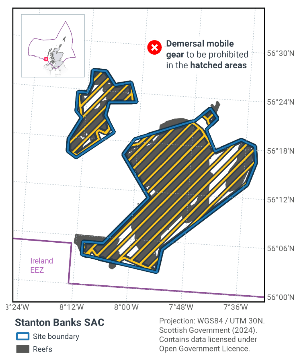
First Area (Demersal mobile gear prohibited)
| Boundary Line | Set of co-ordinates of points which the boundary line joins | Topographic description of boundary line |
|---|---|---|
| 1. | A to B | Loxodrome |
| 2. | B to C | Loxodrome |
| 3. | C to D | Loxodrome |
| 4. | D to E | Loxodrome |
| 5. | E to F | Loxodrome |
| 6. | F to G | Loxodrome |
| 7. | G to H | Loxodrome |
| 8. | H to I | Loxodrome |
| 9. | I to J | Loxodrome |
| 10. | J to K | Loxodrome |
| 11. | K to L | Loxodrome |
| 12. | L to M | Loxodrome |
| 13. | M to N | Loxodrome |
| 14. | N to O | Loxodrome |
| 15. | O to P | Loxodrome |
| 16. | P to Q | Loxodrome |
| 17. | Q to R | Loxodrome |
| 18. | R to S | Loxodrome |
| 19. | S to T | Loxodrome |
| 20. | T to A | Loxodrome |
Where—
"A" is 56° 23.667' N, 008° 14.200' W,
"B" is 56° 23.667' N, 008° 12.033' W,
"C" is 56° 24.800' N, 008° 11.283' W,
"D" is 56° 26.483' N, 008° 11.250' W,
"E" is 56° 26.467' N, 008° 08.150' W,
"F" is 56° 24.850' N, 008° 05.933' W,
"G" is 56° 25.333' N, 008° 02.367' W,
"H" is 56° 22.813' N, 008° 01.628' W,
"I" is 56° 22.583' N, 008° 06.983' W,
"J" is 56° 21.017' N, 008° 07.567' W,
"K" is 56° 20.429' N, 008° 06.912' W,
"L" is 56° 19.345' N, 008° 06.381' W,
"M" is 56° 18.705' N, 008° 07.174' W,
"N" is 56° 19.039' N, 008° 08.780' W,
"O" is 56° 18.793' N, 008° 09.179' W,
"P" is 56° 17.975' N, 008° 08.525' W,
"Q" is 56° 15.763' N, 008° 13.177' W,
"R" is 56° 16.217' N, 008° 15.467' W,
"S" is 56° 17.800' N, 008° 15.433' W, and
"T" is 56° 20.450' N, 008° 12.917' W
Second Area (Demersal mobile gear prohibited)
| Boundary Line | Set of co-ordinates of points which the boundary line joins | Topographic description of boundary line |
|---|---|---|
| 1. | U to V | Loxodrome |
| 2. | V to W | Loxodrome |
| 3. | W to X | Loxodrome |
| 4. | X to Y | Loxodrome |
| 5. | Y to Z | Loxodrome |
| 6. | Z to AA | Loxodrome |
| 7. | AA to AB | Loxodrome |
| 8. | AB to AC | Loxodrome |
| 9. | AC to AD | Loxodrome |
| 10. | AD to AE | Loxodrome |
| 11. | AE to AF | Loxodrome |
| 12. | AF to AG | Loxodrome |
| 13. | AG to AH | Loxodrome |
| 14. | AH to AI | Loxodrome |
| 15. | AI to AJ | Loxodrome |
| 16. | AJ to AK | Loxodrome |
| 17. | AK to AL | Loxodrome |
| 18. | AL to AM | Loxodrome |
| 19. | AM to AN | Loxodrome |
| 20. | AN to AO | Loxodrome |
| 21. | AO to AP | Loxodrome |
| 22. | AP to AQ | Loxodrome |
| 23. | AQ to AR | Loxodrome |
| 24. | AR to AS | Loxodrome |
| 25. | AS to AT | Loxodrome |
| 26. | AT to AU | Loxodrome |
| 27. | AU to U | Loxodrome |
Where—
"U" is 56° 16.350' N, 008° 03.150' W,
"V" is 56° 17.525' N, 008° 01.803' W,
"W" is 56° 17.850' N, 007° 59.823' W,
"X" is 56° 19.045' N, 007° 57.750' W,
"Y" is 56° 21.043' N, 007° 48.447' W,
"Z" is 56° 20.100' N, 007° 46.000' W,
"AA" is 56° 17.583' N, 007° 42.733' W,
"AB" is 56° 19.200' N, 007° 37.167' W,
"AC" is 56° 18.517' N, 007° 33.933' W,
"AD" is 56° 16.433' N, 007° 33.533' W,
"AE" is 56° 13.633' N, 007° 35.150' W,
"AF" is 56° 05.000' N, 007° 52.900' W,
"AG" is 56° 02.117' N, 007° 53.717' W,
"AH" is 56° 03.616' N, 008° 01.198' W,
"AI" is 56° 02.935' N, 008° 02.710' W,
"AJ" is 56° 03.302' N, 008° 06.783' W,
"AK" is 56° 04.255' N, 008° 08.287' W,
"AL" is 56° 04.116' N, 008° 08.677' W,
"AM" is 56° 03.506' N, 008° 09.056' W,
"AN" is 56° 03.599' N, 008° 10.098' W,
"AO" is 56° 03.781' N, 008° 10.018' W,
"AP" is 56° 03.916' N, 008° 10.662' W,
"AQ" is 56° 04.500' N, 008° 10.650' W,
"AR" is 56° 04.549' N, 008° 10.343' W,
"AS" is 56° 05.350' N, 008° 10.633' W,
"AT" is 56° 05.317' N, 008° 06.100' W, and
"AU" is 56° 11.250' N, 007° 56.833' W
Third Area (Demersal mobile gear prohibited)
| Boundary Line | Set of co-ordinates of points which the boundary line joins | Topographic description of boundary line |
|---|---|---|
| 1. | AV to AW | Loxodrome |
| 2. | AW to AX | Loxodrome |
| 3. | AX to AY | Loxodrome |
| 4. | AY to AZ | Loxodrome |
| 5. | AZ to BA | Loxodrome |
| 6. | BA to AV | Loxodrome |
Where—
"AV" is 56° 21.870' N, 007° 46.354' W,
"AW" is 56° 22.850' N, 007° 44.433' W,
"AX" is 56° 21.583' N, 007° 42.600' W,
"AY" is 56° 20.661' N, 007° 44.072' W,
"AZ" is 56° 20.820' N, 007° 44.672' W, and
"BA" is 56° 21.332' N, 007° 44.996' W
Contact
Email: Marine_biodiversity@gov.scot