Scottish Crop Map 2019
The ‘Scottish Crop Map’ shows all the agricultural fields in Scotland categorised into the likely main crop types which were grown in 2019.
Results and Key Findings
The results presented here are on areas of production. The results are provided as a guide to the breakdown of results which are produced from the Scottish Crop Map Model. The Official Statistics are available at Cereal and oilseed rape harvest: 2019 final estimates.
Scotland
In 2019 a total of 347,887 hectares (ha) were modelled and classified as areas growing main type crops in Scotland. In total, the model estimated the crop production in 385,028 fields in Scotland shown in Table 2.
The Scottish Crop Model identified and classified fields as growing either:
- Grassland;
- Spring barley;
- Spring oats;
- Winter barley; or
- Winter wheat.
Other crop types are not available from the current model and fields growing mixed crops are also not included, but may be classified as whole fields.
| Crop Type | No. of Fields Predicted | Percentage of Total (%) |
|---|---|---|
| Grassland | 303,026 | 78.7 |
| Spring Barley | 20,935 | 5.4 |
| Spring Oats | 169 | > 0.0 |
| Winter Barley | 4607 | 1.2 |
| Winter Wheat | 8731 | 2.3 |
| Unclassified | 47560 | 12.4 |
| Total | 385,028 | 100 |
Source: Scottish Crop Map 2019, RESAS
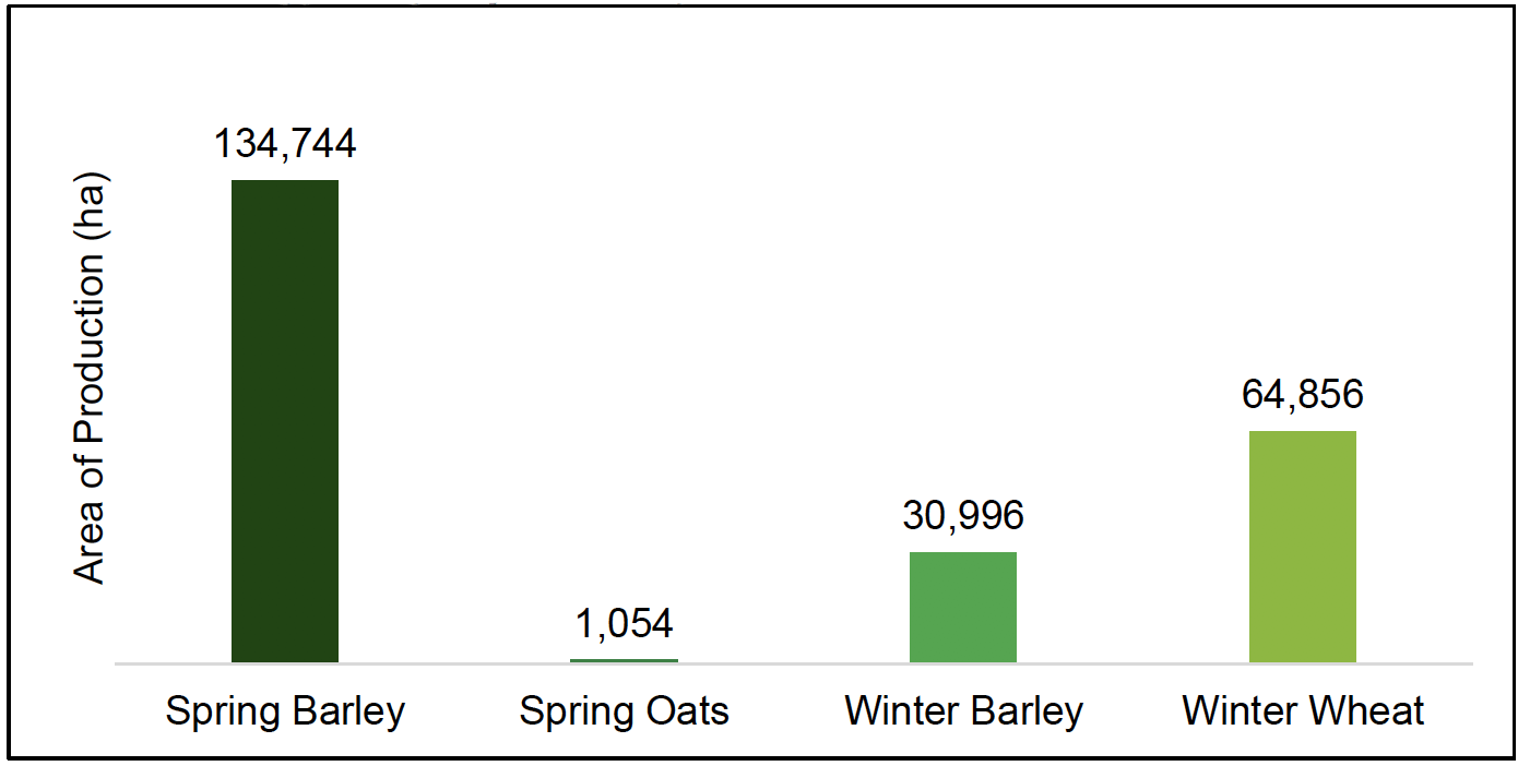
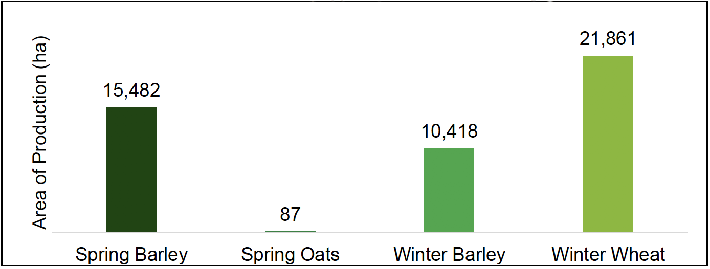
The predominant cereal crop grown in Scotland is Spring Barley with an estimated growing area of 134,744 ha. Over half the area, at just over 58%, of land used for cereal production was used for Spring Barley which is shown in Chart 1.
The second most popular crop production, totalling 64,856 ha, is used for winter wheat in terms of area for 2019. At 28% this is just over a quarter of all land used for cereal production. Winter Barley production areas totalled 30,996 ha accounting for 13% and was the third most popular. Spring Oats production made up less than one per cent of all area with only 1,054 ha.
Of the total agricultural land available for cereal production, most land is used for grassland and pasture with over 1.8 million ha set aside for grassland.
Source: Scottish Crop Map 2019, RESAS
Regional Breakdown
The largest areas for crop production are in the North East Scotland and Eastern Scotland regions. Both of these regions combined account for nearly two thirds of the total cropping area of Scotland and a total of 156,730 ha
| Region | Area (ha) | Percentage of Total (%) |
|---|---|---|
| Eastern Scotland | 93,683 | 40 |
| Highlands and Islands | 25,847 | 11 |
| North East Scotland | 63,047 | 27 |
| Southern Scotland | 47,849 | 21 |
| West Central Scotland | 1,224 | 1 |
| Total | 231,650 | 100 |
Source: Scottish Crop Map 2019, RESAS
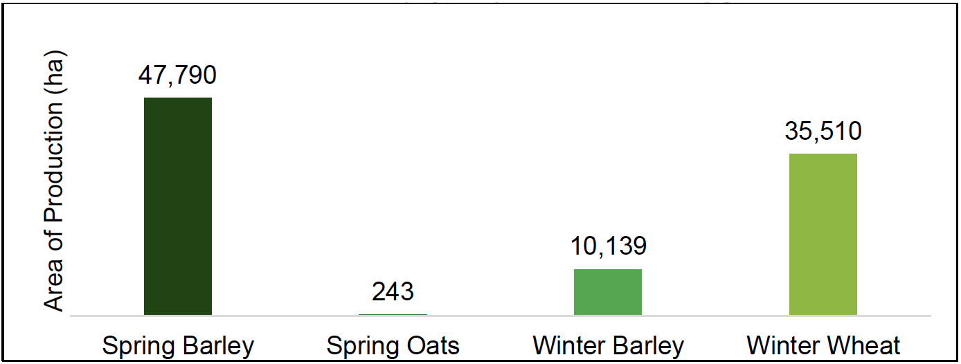
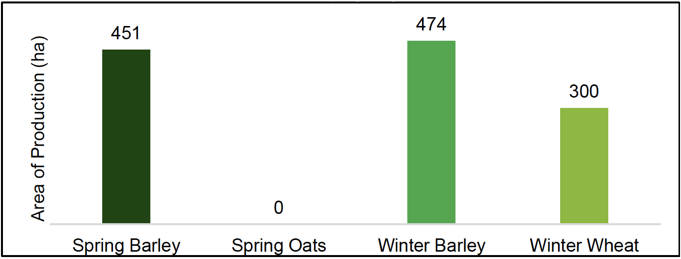
Eastern Scotland and Southern Scotland predominantly grow winter wheat as shown in Charts 2 and 5, with 35,510 ha and 21,861 ha respectively.
West Central Scotland has the lowest growing area of all five regions, however this region covers the Glasgow City area and conurbations.
Source: Scottish Crop Map 2019, RESAS
Source: Scottish Crop Map 2019, RESAS
Source: Scottish Crop Map 2019, RESAS
Source: Scottish Crop Map 2019, RESAS
Source: Scottish Crop Map 2019, RESAS
Source: Scottish Crop Map 2019, RESAS
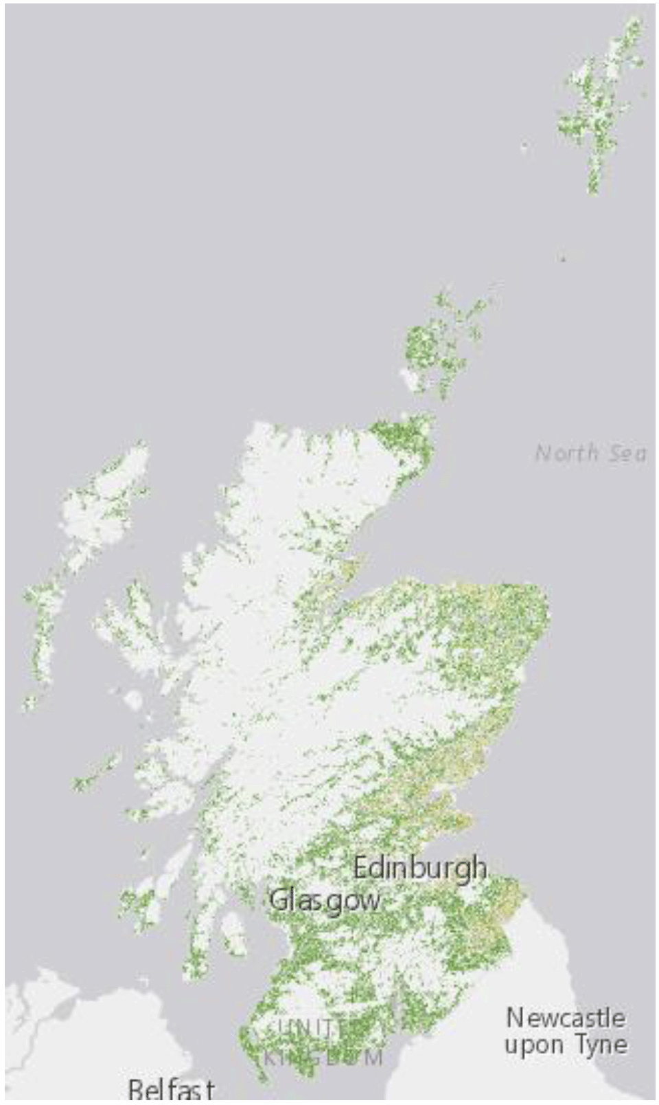
Grassland, featured as darker green on Map 1 (left), is a predominant feature of fields and the Scottish landscape in general. Most grassland is found in areas where there is a higher proportion of Less Favoured Area (LFA) land. LFA can be defined as the presence of poor land of poor productivity, which is difficult to cultivate and with a limited potential which cannot be increased except at excessive cost.
Therefore this land will be used to cut sillage and other forage for beef and dairy cattle and sheep.
Of the fields included in the Scottish Crop Map, 1.8 million hectares was used for grassland.
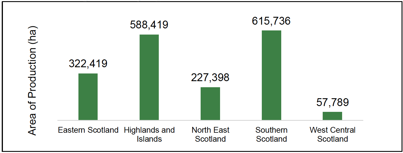
The highest areas used for grassland is the Highlands and Islands and Southern Scotland. In total 1.1 million hectares of fields were used for grassland, which is over two thirds. This is shown on the charts on the previous page.
Other grassland not designated within field boundaries in the crop map may also be used for keeping livestock outdoors, such as hill and other inaccessible areas.
Contact
Email: agric.stats@gov.scot