Measuring biodiversity: research into approaches
This report considers methodologies for measuring biodiversity at site-level for use in Scotland.
Results: Metric 3.1 Applicability Scotland
Introduction
This section explores the suitability of Biodiversity Metric 3.1 as a means of accounting for biodiversity in Scotland. It compares the UK Hab system of classifying habitats, with the EUNIS system. It determines if habitats of conservation concern (at the Scottish and wider European level) are already included in the metric and provides an indication of how transferable habitat distinctiveness ratings are. It also identifies the availability of datasets, and assesses how appropriate the condition assessment and risk multipliers are with respect to the Scottish context. Finally we explore the underpinning capacity required to undertake and administer metric use in order to identify skills, staffing and training needs.
To determine applicability to Scotland, it is important to consider how regulations governing planning differ between Scotland and England. While achieving a minimum 10% BNG will become mandatory in England from November 2023, in Scotland there are no plans for a mandatory or otherwise quantitative target. The National Planning Framework 4 (NPF4)[22] sets out policies to protect biodiversity, reverse biodiversity loss, deliver positive effects from development and strengthen nature networks (Policy 3). To ensure that positive effects for biodiversity are delivered, it is crucial that there is a standardised and transparent way to measure and account for biodiversity.
Metric 3.1 provides a tested means of accounting for biodiversity. While Metric 3.1 has a user-friendly interface to assist decision makers, some ecological knowledge is required. From a regulatory perspective there is concern that Scotland does not have the capacity to assess development proposals to ensure that they demonstrate biodiversity enhancement. To equip decision makers there is a need for clear guidance and to ensure resources are provided to upskill regulators. Furthermore the User Guide (including Principles and Rules that underpin metric use) and Technical Annexes (including Technical Supplement and Habitat Condition Assessment Sheets) that accompanies Metric 3.1 will need to be redrafted to ensure that they are fit for purpose in Scotland.
Key insights and recommendations – sector applicability
- The guiding principles for BNG align with Scotland's commitment to deliver positive effects for biodiversity, however, statutory requirements for 10% BNG linked to frameworks for the purchase of government credits do not apply in Scotland.
- Recommendation 1. Ensure supporting information is fit for purpose in Scotland.
- Recommendation 16. Determine Scotland's capacity to administrate from a regulatory perspective and provide training to equip decision makers to assess development proposals to ensure they deliver positive effects for biodiversity.
Irreplaceable Habitats: The Scottish context
Here we identify the requirement for a definitive list of irreplaceable habitats in Scotland. We consider the impact of bespoke compensation with respect to industry and regulatory bodies. Finally, we identify datasets that can be used to determine the extent and location of habitats of conservation concern and outline limitations of these datasets.
Irreplaceable habitats require bespoke compensation and are protected through protected species and habitats legislation and policies. As ancient woodlands and veteran trees are not a habitat in their own right these are not specifically identified in Metric 3.1. Using existing spatial datasets (i.e. Native Woodland Survey of Scotland[23], Caledonian Pinewood Inventory[24]) or integrating information on habitat type and condition may allow for ancient woodlands to be more accurately accounted for (see below). For consistency, it is recommended that all irreplaceable habitats are included within a Scottish metric. To achieve this, a comprehensive list of irreplaceable habitats for Scotland would have to be produced and agreed, and this process will should also use spatial datasets of these habitats where available.
The renewables industry have expressed concerns regarding applying the BNG Metric 3.1 approach to large scale projects in the uplands (e.g. windfarms). The large red line boundary of windfarm sites (i.e. total site footprints) together with the prevalence of peatland means developments have a high likelihood of encountering this irreplaceable habitat. Applying BNG to the entire site footprint is considered by the industry to challenge the viability of developments and, from a regulating body perspective, providing guidance on bespoke compensation would require additional staff resourcing. A possible solution is to only apply BNG to the areas directly impacted by development (i.e. tracks and turbines with an appropriate buffer determined via site topography and hydrology). Over 20% of Scotland is covered by peat, to help to ensure a viable solution is reached we recommend consultation with industry, peatland experts and for windfarm sites the Onshore Wind Strategic Leadership Group.
Key insights and recommendations – irreplaceable habitats
- Recommendation 2. Refine Natural England's forthcoming list of irreplaceable habitats to reflect such habitats in Scotland.
- Recommendation 3. All irreplaceable and Annex 1 habitats in Scotland and those on and the Scottish Biodiversity list should be included in a Scottish Metric and be given an appropriate distinctiveness rating.
- Recommendation 4. Identify a solution to ensure that peatlands are correctly accounted (e.g. through consultation with industry and peatland experts).
Trading rules: The Scottish context
This section outlines the applicability of Metric 3.1's trading rules to the Scottish Context. It explores how Metric 3.1 combines habitats of different conservation values, and highlights the potential to integrate information on Distinctiveness and Condition to better reflect biodiversity value of a habitat.
Metric 3.1's trading rules are based primarily on habitat distinctiveness and thus on a habitat's inherent potential to benefit biodiversity, with additional rules targeted to promote the retention of woodland habitats. The rules are designed to ensure that habitats created or enhanced to meet BNG are of equal or greater inherent value than any habitats lost. This aligns with Scotland's commitment for developments to have positive effects for biodiversity and woodland creation targets (i.e.18,000 ha per year from 2024/25).
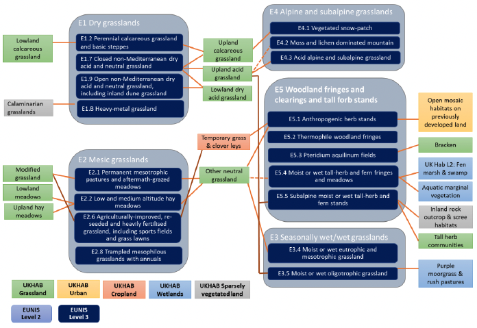
Metric 3.1 assigns habitat distinctiveness at UK Hab Level 4, however Level 5 is typically required to identify Annex 1 habitats (Butcher et al. 2020a). Consequently, in some instances Annex 1 habitats are grouped with habitats of lower biodiversity and their value is not recognised. To avoid amalgamating habitats of different conservation value, Scotland could adopt a more detailed classification system in which to base trading rules. However, this would also result in a more complicated tool to use. Trading rules that integrate information on both condition and distinctiveness may allow for greater separation of habitats based on their conservation value without the requirement for more complex categorisation. A stakeholder poll indicated this was more preferential than trading rules solely based on distinctiveness (Annex 5 Figure 18a). Care would have to be taken to ensure that integrating distinctiveness and condition provides a robust means of accounting for biodiversity to ensure that we don't lose inherently valuable habitats due to poor condition.
Key insights and recommendations – irreplaceable habitats
- Metric 3.1's trading rules are in line with Scottish planning, biodiversity and woodland creation policies.
- Recommendation 5. The potential to base trading rules on both distincitiveness and condition should explored, this may avoid the need for a more detailed and complex habitat classification system.
Habitat classification: The Scottish context
This section explores how fit Metric 3.1's habitat classification systems are with respect to categorising Scottish habitats. It explores EUNIS as a potential alternative to UK Hab for terrestrial habitats. It delves deeper into the habitats included in Metric 3.1 to identify if any habitats of conservation concern present in Scotland are not accounted for.
The classification systems that Metric 3.1 adopts are largely derived from systems developed for use in UK or Europe and are thus fit for purpose in Scotland (Table 10). For species-rich hedgerows, the guidance adjusts the number of woody plant species to reflect geographical differences with adjustments including Scotland.
Most terrestrial habitats are classified in the UK Hab system. With some ecologists in Scotland using Phase 1, Metric 3.1's means of crosslinking these two classification system provides flexibility and would alleviate training needs. There are clear problems with Metric 3.1 current crosslinks, and we would prioritise ensuring that these crosslinks are accurate and fit for Scottish habitats.
EUNIS is an alternative pan-European classification system which provides a framework to classify habitats (terrestrial, intertidal, urban), helping EU member states meet the INSPIRE Directive requirements to standardise spatial datasets (Strachan, 2017). There is a comprehensive Manual of terrestrial habitats in Scotland based on this system (Strachan, 2017). EUNIS is used by NatureScot for collating and mapping data, and recent NatureScot spatial datasets adopt this system, providing resources to support metric use.
Space Intelligence have derived the SLAM-MAP[25] of Scotland in the EUNIS classification system by classifying satellite imagery using Artificial Intelligence. This map is open source and provides a habitat map covering all of Scotland. Habitat classifications are, however, at a relatively broad level (EUNIS Level 2), resolution is low (i.e. 20 m) and information on habitat quality is lacking. This map could, however, support on the ground habitat mapping or be used where large-scale assessments are required. Indeed, EUNIS forms the basis of Scotland's Natural Capital Asset Index and the SLAM-MAP has been used to refine this index.
UK Hab and EUNIS take a hierarchical approach to habitat classification, with more detailed habitat descriptions nested within broader descriptions. The Metric classifies most terrestrial habitats using UK Hab L4 which typically provides an intermediate level of detail between EUNIS L2 and EUNIS L3 (Table 11). This trend is, however, not observed for Cropland where categorisation at UK Hab L4 is more refined than EUNIS L3. Metric 3.1 recognises 13 different types of hedgerows, whereas EUNIS L3 only recognises 5 categories of hedgerows. While EUNIS has distinct categories for habitat mosaics, UK Hab typically accounts for mosaics by dividing these into the individual habitat the mosaic is made up from. This undervalues the ecological benefits of habitat mosaics. It is worth noting that open mosaic habitats on previously developed land are treated as a habitat in their own right and give a High distinctiveness rating.
| EUNIS Level 1 |
EUNIS Level 2 |
EUNIS Level 3 |
UK Hab Level 2 |
UK Hab Level 4 |
|---|---|---|---|---|
| Grasslands and lands dominated by forbs, mosses or lichens |
5 |
18 |
Grassland |
13 |
| Woodland, forest & other wooded land |
4 |
17 |
Woodland & forest |
13 |
| Mires, Bogs and Fens |
3 |
7 |
Wetland |
8 |
| Grasslands and lands dominated by forbs, mosses or lichens |
5 |
18 |
Grassland |
13 |
| Mires, Bogs and Fens |
3 |
7 |
Wetland |
8 |
| Heathland, scrub and tundra Excluding hedgerows Hedgerows* |
5 1 |
12 4 |
Heathland & shrub Hedgerows |
12 13* |
| Inland unvegetated or sparsely vegetated habitats |
4 |
16 |
Sparsely vegetated land |
8 |
| Regularly or recently cultivated agricultural, horticultural habitats |
2 |
5 |
Cropland |
11 |
| Inland surface waters Excluding surface running waters Surface running waters |
2 1 |
12 5 |
Lakes Rivers |
11 5 |
| Habitat complexes |
17 |
*Hedgerow classification is metric specific and draws from Defra's Hedgerow Survey Handbook.
While UK Hab and EUNIS don't directly correspond to each other, it is possible to crosslink habitats via existing correspondence tables (UK Habitat Classification Working Group, 2018). Annex 5 provides a cross reference of EUNIS categories of Scottish habitats (Strachan 2017) with UK Hab. Crosslinking the two classification systems, particularly at more refined levels is, however, complex (Figure 9). For example, in some instances UK Hab L4 classifications link to multiple EUNIS L3 classification, while in other cases a single EUNIS L3 classification links to multiple UK Hab L4 classifications. Furthermore, while there is a tendency for habitats in the broad EUNIS L1 group Grasslands and lands dominated by forbs, mosses or lichens to be aligned to those in the UK Hab L2 group Grassland this is not always the case. For example, EUNIS L3 Heavy-metal grasslands, fell under UK Hab 2 Sparsely vegetated land. Consultation with stakeholders revealled a familiarity and preference for UK Hab. We discuss Scottish habitats omitted from this classification in the following section.
Key insights and recommendations – habitat classification
- Hierarchical classification systems like UK Hab and EUNIS allow for varying levels of precision providing flexibility to meet the needs of different sectors and applications within a sector.
- Allowing habitat types to be input in different classification systems and crosslinking these systems can be problematic (e.g. as seen with Phase 1 and UK Hab – see Section: Limitations of the Biodiversity Metric 3.1).
- Recommendation 6. Ensure crosslinks between Phase 1 and UK Hab work are fit for purpose through consultation with habitat experts.
Distinctiveness: The Scottish context
In this section, we look at how Distinctiveness classifications could be adapted for Scotland and identify relevant Scottish data sources that could assist in this process. We identify if any habitats of conservation importance within Scotland are missing from Metric 3.1.
For terrestrial habitats, once a habitat classification system for the Scottish Metric is agreed, distinctiveness could be derived from assessing the rarity, protection, and conservation importance of each habitat in Scotland using the approach adopted by Metric 3.1. Rarity could be calculated from the total remaining area within Scotland (this information is presented in rough values in the Scottish Biodiversity List[26]), protection as a percentage of each habitat's coverage within protected sites (SSSI, SPAs, SACs, RAMSAR sites, Marine Consultation Areas, and Marine Protected Areas) and conservation importance could be derived from the Scotland Biodiversity List, UK Priority Habitats, and European Red List.
Several spatial datasets are available to help identify the location of protected sites and location and extent of habitats of conservation concern. These maps are open access and freely available on the Scotland's environment map[27].
Metric 3.1 identifies five broad river categories specifically: Priority Rivers (Very High Distinctiveness), Other rivers and Streams (High), Ditches (Medium), Canals (Medium) and Culverts (Low). While this framework would be applicable, Scotland does not have a Priority Rivers map. The Water Classification Hub[28], however, classifies rivers into five condition categories based on ecology, chemistry and hydrology and could provide a suitable alternative. This dataset was utilised in NatureScot's draft tool for natural capital assessment on farms.
As in England, Scottish lake typology can be determined via the UK Lakes Portal[29] and the assignment of distinctiveness could follow the same approach as Metric 3.1. Similarly, Metric 3.1 takes a relatively straightforward approach to determining the distinctiveness of intertidal habitats based on the rarity of substrate and naturalness. This methodology would be directly transferable to the Scottish Context.
Spatial data include the Scottish Wetland Inventory and Caledonian Pinewood Inventory and information on peatlands (i.e. blanket bogs, lowland raised bogs) are mapped in the Carbon and Peatland map 2016. The Habitat Map of Scotland (HabMoS) provides coverage of:
- HabMoS Coastal and Vegetated Shingle
- HabMoS Saltmarsh
- HabMoS Sand Dune Vegetation
- HabMoS Native Woodland
- HabMoS Freshwaters
- HabMoS NVC to Annex I
The HabMoS freshwater layer also contains information on freshwater habitats including Annex 1 classification.
These spatial datasets draw from the best available information, with surveys varying in methodology, scope and accuracy. The availability of data will vary between habitat types, with some habitats (e.g. woodlands and saltmarsh) having more comprehensive information than others (e.g. calcareous grasslands). There may be inaccuracies due to the conversion of data from NVC to EUNIS. In some instances (e.g. NVC to Annex 1) the data is incomplete or outdated – (e.g. HabMoS Sand Dune Vegetation Survey 1994-1998). A review of the extent, coverage, and accuracy of these spatial datasets, and their transferability for use in calculations of Biodiversity is thus recommended. An alternative, short-term solution, would be to consult with key stakeholders and ecologists to determine where changes to current distinctiveness scores would be required. Indeed, this process would validate the fitness of strategic significance, and risk multipliers in the Scottish context.
To determine if any terrestrial Scottish habitats of conservation concern are excluded from Metric 3.1, we cross-referenced habitats on the Scottish Biodiversity List and Scottish habitats identified as UK BAP Priority Habitats[30] with Metric 3.1 habitats. Additionally, to account for internationally important habitats in Scotland, we determined if all Annex 1 habitats present in Scotland (Strachan 2017) were included in the Metric's Technical Supplement (Panks et al. 2022).
Six Annex 1 habitats are not mentioned in the Biodiversity Metric 3.1 Technical Supplement (Panks et al. 2022) (Table 12). Except for Machair (an Annex 1 habitat), these habitats could be assigned to UK Hab cateogories (Panks et al. 2022). Machair occurs as a habitat complex and consequently UK Hab categorises it using a combination of habitat codes – including grassland, saltmarsh and sand dune and it additionally falls under the secondary UK Hab code 26 (Butcher, et al. 2020a). Metric 3.1 recommends that habitat complexes are assigned based on the approximate area of each habitat, however, this fails to capture the biodiversity benefits that habitat mosaics provide (e.g. high diversity of niches and microhabitats). A Scottish metric should therefore include Machair as a habitat in its own right. We would recommend a Very High distinctiveness rating to reflect national and international importance, and requirement for bespoke compensation. The addition of machair would also require the development of condition assessment criteria and appropriate risk multipliers.
Of the remaining Annex 1 habitats not included in the technical guidance, four fell under UK Hab L4 habitats rated to be of High distinctiveness (i.e. Upland calcareous grasslands, Lowland calcareous grasslands and Lowland Heath , see Table 12). The remaining Annex 1 habitat, Siliceous alpine and boreal grasslands, fell under the UK Hab group Upland acidic grassland which is rated as Medium distinctiveness. Juncus squarrosus-Festuca ovina grassland which is on the Scottish Biodiversity List, but is not an Annex 1 habitat, also fell into Upland acidic grasslands. The significance of these two habitats from a Scottish perspective indicates that Metric 3.1's current categorisation of Upland acidic grasslands as Medium distinctiveness may not be appropriate for Scotland. However, it is recognised Upland acid grassland dominates large areas of Scotland and it is typically species poor. Trading rules that integrate distinctiveness and condition would help to avoid grouping habitats of different innate value (see above).
This exercise highlighted that the Annex 1 habitat Caledonian forest (H91C0) which is unique to Scotland is included in Metric 3.1 Technical Supplement. This habitat fell into the broader grouping Native pine woodlands which are categorised to have High Distinctiveness. This Annex 1 habitat is considered Near Threatened and it does not occur elsewhere in the UK or Europe. Native pine woodlands should therefore be upgraded to Very High Distinctiveness to reflect their high conservation value and the requirement for bespoke compensation under a planning framework. Indeed, when adapting the Biodiversity Metric 3.1 for use in the Scottish context SSE Networks have upgraded Native pine woodlands to Very High distinctiveness (Scottish and Southern Electricity Networks 2019).
Arable field margins are classified as Medium distinctiveness despite being a Priority habitat in England as well as Scotland. Arable field margins are key habitats to create ecological connectivity across the wider countryside and provide a wide range of ecosystem services that underpin food production (e.g. pollination and natural pest control). However, they fail to reflect the inherent quality of semi-natural habitats categorised as High or Very High distinctiveness. Thus it is proposed that the current distinctiveness score is appropriate.
| Habitat and extent |
Scottish Biodiversity List EUNIS Code (Strachan 2017) |
Red list name/ status |
Distinc-tiveness |
|---|---|---|---|
| Machairs (H21A0): Unique to NW Scotland and W Ireland. Approximately 60% of the global extent of this habitat is thought to be found in Scotland. |
Machair |
Machair Least concern |
n/a |
| Juniperus communis formations on heaths or calcareous grasslands (H5130). Relatively widespread but local habitat found across Europe. Scattered patches in England and Scotland, very rare in Wales, absent from Northern Ireland. |
Lowland calcareous grassland Lowland heathland EUNIS: F3.16#1 |
Lowland to montane temperate & submediterranean Juniperus scrub Least concern |
High |
| Siliceous alpine and boreal grasslands (H6150). Restricted distribution in Europe. Extensive areas occur primarily in Scotland, with the habitat also present in N England, N Wales and Northern Ireland. |
n/a EUNIS: E4.115# + E4.117 + E4.21 + E4.32 + F2.11 |
Boreal and arctic acidophilous alpine grassland Least concern |
Medium |
| Alpine and subalpine calcareous grasslands (H6170). Largely restricted to Alpine and Boreal Biogeographical regions in Europe. UK largely restricted to the Scottish Highlands. Absent from Northern Ireland and England. |
Upland calcareous grassland EUNIS: E4.12 + F2.29#1 |
Arctic-alpine calcareous grassland Least concern |
High |
| Semi-natural dry grasslands and scrubland facies: on calcareous substrates (Festuco-Brometalia) (H6210). Scare and threatened in Europe. Occur widely in calcareous substrate in England and Wales, but are restricted in Scotland and Northern Ireland. |
Upland calcareous grassland EUNIS: E1.26 |
Perennial rocky calcareous grassland of subatlantic-submediterran-ean Europe Vulnerable |
High |
| Species-rich Nardus grassland, on siliceous substrates in mountain areas (H6230). Rare in mainland Europe. Widely found in the UK, particularly in Scotland. Annex 1 description includes Nardus stricta-Galium saxatile grasslands which are on the Scottish Biodiversity list. |
Upland calcareous grassland EUNIS: E1.72# |
Lowland to submontane, dry to mesic Nardus grassland Vulnerable |
High |
| Scottish Biodiversity List habitat that is not an Annex 1 habitat, nor on the Priority Habitats Inventory (England). EUNIS code cross references this habitat to UK Hab L4 Upland acidic grasslands. |
Juncus squarrosus-Festuca ovina grassland EUNIS: E3.52 for NVC U6 |
n/a |
Medium |
An overview of extent at the UK and European level is indicated (source: JNCC%20website">JNCC website). Cross links between Annex 1 habitats and the Scottish Biodiversity List are provided (UK Habitat Classification Working Group 2018). Distinctiveness as outlined in Biodiversity Metric 3.1 and Red List status (EU Environment Agency: EUNIS terrestrial habitat classification 2021_1 including crosswalks).
In addition to the habitats listed in Table 12, Metric 3.1 fails to recognise ancient woodlands or ancient or veteran trees (see above). Most woodlands are categorised as High or Medium distinctiveness which is inappropriate for irreplaceable ancient woodlands. It is recommended that all habitats of conservation concern (i.e. Annex 1 habitats and those on the Scottish Biodiversity List) are included in a Scottish metric and assigned appropriate distinctiveness ratings based on consultation with key stakeholders, including ecologists.
Key insights and recommendations - distinctiveness
- Distinctiveness could be determined using similar/or identical methodologies to those adopted in Metric 3.1.
- Recommendation 7. Determine the availability, extent and accuracy of existing spatial datasets and determine their suitability for use in biodiversity calculations.
- Recommendation 8. Consult with key stakeholders including ecologists to validate the fitness of distincitveness, strategic significance, and risk multipliers for use in Scotland.
- Recommendation 3. All irreplaceable and Annex 1 habitats in Scotland and those on and the Scottish Biodiversity list should be included in a Scottish Metric and be given an appropriate distinctiveness rating.
Habitat condition: The Scottish context
Within this section, we evaluate that applicability of Metric 3.1's habitat condition assessment criteria to Scottish habitats.
The criteria for condition assessments outlined in Metric 3.1 are typically drawn from UK wide standards (i.e. JNCC's Site Condition Monitoring Guidelines; Defra's Hedgerow Survey Handbook: Defra 2007, The Freshwater Biological Association's Habitat Naturalness Assessment) and thus assessment criteria should be applicable to Scottish habitats. Our review of condition criteria found that this was largely the case.
For terrestrial habitats communities of indicator plant species are outlined in the UK Hab definitions; a classification system developed for the entire UK (Butcher et al. 2020b). Negative plant indicators were largely derived from the JNCC's Site Condition Monitoring Guidelines. Depending on habitat, these indicators reflected high nutrient status (e.g. grasslands, orchards, sparsely vegetated land), bracken/gorse encroachment (heathlands), or the presence of non-native species (scrub, woodland). The species listed are appropriate for Scotland, although one of the negative indicators for scrub Alianthus altissma has a restricted range. Saltmarsh species differ between Scotland and England, and the characteristic species for vegetation zones should be refined. For example, Atriplex portulacoides is primarily restricted to more southern areas of Scotland.
For grassland and woodland habitats, condition scoring depends on the number of species present. For example, for a grassland to be of medium distinctiveness it should support nine or more species per m2 while a woodland parcel in good condition would require five or more native tree or shrub species. Concerns have been raised that these species counts are too high for Scotland, particularly in harsher environments (e.g. higher elevations, or exposed locations). We would recommend consulting experts to ensure that condition criteria are appropriate for the wide range of environmental conditions and to determine if refinement is necessary.
Metric 3.1 uses the MoRPh methodology to assess river condition. Communication with Prof Angela Gurnell indicates "The 13 river types used in England should work fine in Scotland. The main issue is high-energy multi-thread river types, which could be subdivided but that is unlikely to be critical in the present context, where braided, island braided and wandering rivers have sufficiently similar features to be lumped into the same type." Attributes measured in the field assessment are applicable to Scotland, however, the relative weighting of the condition indicators may need refinement through consultation with experts. The MoRPh survey is the only assessment where assessors require formal accreditation. This requirement for accreditation would have to be consiered in Scotland's capacity to deliver.
Indicators for ponds, lakes, intertidal and coastal habitats reflect a range of physical and biological aspects relating to naturalness and water quality which are deemed appropriate for Scotland. Negative indicators included several invasive species that have not yet been recorded in Scotland (e.g. Zebra mussel, Demon shrimp). These species are, however, listed in The Scotland River Basin District (Status) Directions 2014. Given the ecological consequence of non-native species entering Scottish waterbodies expanding negative indicators to include all species listed under Schedule 3 of Directions 2014 would raise awareness and increase vigilance.
Key insights and recommendations – habitat condition
- Recommendation 9. Condition assessments were drawn from UK standards and were thus largely appropriate to Scotland. It is recognised that slight differences may occur, and it is therefore recommended that condition criteria are assessed by habitat experts.
- Recommendation 15. Assess Scotland's capacity to deliver on the ground surveys and determine potential skills gap (e.g. surveyors competent in UK Hab, MoRPh River assessment accreditation).
Strategic significance: The Scottish context
This section explores the relevance of applying a strategic multiplier to Scotland. We identify the appropriateness of local strategies to identify action, indicate limitations, and explore wider spatial datasets that could help underpin decision making at the local and regional level.
In helping to prioritise where habitats are created, strategic multipliers provide a vehicle to help Scotland realise it's ambition to create nature networks that link nature-rich habitats through corridors and stepping stones. In Metric 3.1 this multiplier provides an uplift for habitats with medium to high strategic significance (i.e. biodiversity units are multiplied by 1.1 and 1.15 respectively). Given the importance of ecological connectivity to ecosystem resilience, these values appear quite low and it is recommended that the appropriateness of all Metric 3.1 multipliers are assessed by key stakeholders, including ecologists. Any change in multipliers should also take into account how the different multipliers interact to avoid perverse outcomes (see above).
As in England, strategic significance could be identified through local strategies including Local Biodiversity Action Plans, Local Climate Change Strategies, Catchment Management Plans, Land use strategy (LUS) pilots, and spatial targeting of Agri-Environment and Climate Measures. It is, however, important to note that these strategies are unlikely to have been developed with Biodiversity offsetting/markets in mind. Local plans will, vary in their approach and suitability will differ with respect to the level of detail, spatial extent and habitats considered. We recommend that local strategies are reviewed to ensure they provide a suitable framework to assign strategic significance and that guidelines are drafted to assist in this process.
Opportunity mapping can help to spatially target habitat creation to optimise connectivity and such mapping could provide an important resource when determining strategic significance (see Landscape structure: The Scottish context). As with Metric 3.1, allowing strategic significance to draw on ecological expertise would allow for greater flexibility in determining what is desirable in a local area.
Key insights and recommendations – strategic significance
- Recommendation 10. Undertake a review of local strategies to ensure they provide a suitable vehicle to assign strategic significance and that guidelines are drafted to assist in this process. Strategic multipliers should be included in this review.
- Spatial datasets such as opportunity mapping could underpin the development of a standardised reference to spatially target habitat creation.
Accounting for risk: Scotland
Technical difficulty multipliers: The Scottish context
Here we explore the fitness of technical difficulty multipliers for use in Scotland; determining where risks are likely to be similar and where they are most likely to differ. We explore if an average risk multiplier per habitat is appropriate for Scotland and consider means of refinement to include site specific risks.
Metric 3.1 gives each habitat an average value for technical difficulty in habitat creation and an alternative value for enhancement based on key factors that influence risk, expert opinion and the literature (ENTEC 2011; ENTEC/AMEC 2013, AMEC 2016 – and references there in). Habitat creation multipliers are broad, with only four levels of classification (i.e. Low, Medium, High and Very High) making them easier to assign. For example, irreplaceable habitats (e.g. limestone pavements, Blanket bogs and Aquifer fed naturally fluctuating water bodies) are given a Very High difficulty rating reflecting their irreplaceable nature, whereas heavily managed habitats (e.g. cereal crops and vegetated gardens), or habitats that naturally regenerate (e.g. gorse scrub), are given a Low rating.
The factors considered for technical risks are comprehensive and relevant in a Scottish context (see Section Technical Difficulty Multiplier: Natural England's Biodiversity Metric 3.1). As in England, semi-natural habitats with specific hydrological and/or salinity requirements (e.g. Wetlands, Lakes, Coastal and Intertidal habitats) are typically more difficult to create and technical risk factors of High to Very High reflect this. Similarly, habitats with specific soil requirements (e.g. nutrient status and pH), are also trickier to create particularly when this deviates from normal conditions (e.g. calcareous grasslands in the uplands where soils tend to be acidic).
While risk multipliers largely appear sensible in the Scottish context some adjustments may be necessary, particularly when conditions and habitats are likely to deviate between Scotland and England. For example, upland habitats, and in particular woodland habitats are typically more technically difficult to create and enhance in Scotland than in England due to accessibility, exposure, and deer browsing. Furthermore, site conditions are likely to show a greater degree of variation in Scotland and thus an average difficulty rating for each habitat is less applicable. To account for this, a Scottish Metric could alter technical difficulty multipliers (and indeed Temporal multipliers) to reflect site specific risks. To achieve this, an increase in information on site conditions for habitat creation/ enhancement would be required at the Metric input stage. For example, the risk associated with Woodland creation could be reduced at lower elevations and in areas of low deer density. Supporting information could be derived from free source online spatial datasets (e.g. elevation, aspect, exposure, hydrology, deer numbers) and simple drop down menus (e.g. deer fencing/tree guards).
There is the potential to provide flexibility to alter risk multipliers based on local knowledge and professional advice and include justification for any changes. This could take into account the current habitat and its condition and proposed enhancement. For example, enhancing a blanket bog that requires drain blocking will be easier to achieve than where reprofiling peat hags is required. From a planning perspective, such information is likely to be already required for habitat creation/ enhancement management plans and is therefore achievable with minimum additional effort. Increasing flexibility, however, results in lower reproducibility and clear rules would be needed to reduce the risk of 'green-washing' or abuse. In the longer term, technical risk could draw on site-specific factors derived from existing data sources increasing transparency.
It is also important to note that there are considerable technological advancements in habitat creation (e.g. coastal saltmarshes) and enhancement techniques (e.g. peatland). The enhancement of Blanket Bog is given a High rating indicating a high level or risk, and low success rate. Technical multipliers should therefore be assessed relatively frequently (e.g. every five years) to ensure that they continue to be relevant.
Key insights and recommendations – technical difficulty
- Recommendation 11. Due to greater variation in environmental conditions across Scotland average risk multipliers based on habitat type are not appropriate in Scotland. Greater flexibility in the assignment of risk multipliers to reflect site conditions is recommended.
- Recommendation 12. Explore the potential to integrate spatial datasets to alter risk multipliers to better reflect site specific risks.
Spatial risk multipliers: The Scottish context
This section highlights the appropriateness of applying spatial risk multipliers when offsetting biodiversity in Scotland. It compares assigning this risk based on both administrative boundaries and more natural boundaries that reflect landscape characteristics.
Where offsetting is required, the spatial risk multiplier in Metric 3.1 incentivises off-site habitat creation/enhancement within the same Local Planning Area or National Character Area (although this could favour action at a greater distance than sites in an adjacent LPA or NCA). In the local context this has positive implications for both people and biodiversity and is thus aligned with NPF4. As the Biodiversity Metric uses English Local Authority Areas, National Character Areas and Marine Plan Areas, a Scottish Metric would have to determine what is the most appropriate Scottish equivalent.
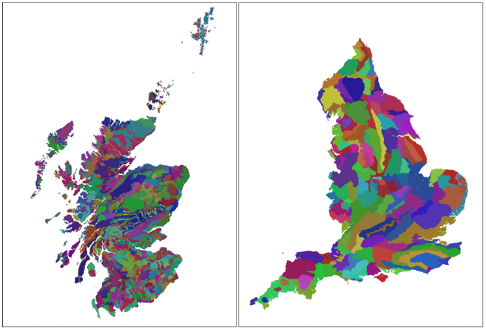
In Scotland, Planning Authorities are delivered across 32 council areas and two national park authorities. Scottish local council areas vary greatly in size (from 60km2 of Dundee City to 25,657km2 of Highlands). English Local Planning Authorities (i.e. borough and district councils and unitary authorities) are more consistent in size reflecting urban areas and population size. Urban local authorities are comparable in size in both Scotland and England, but more rural English local authorities are generally smaller than those in Scotland[31]. Disparity between the size of Scottish local authority areas brings into question if this approach could result in an imbalance, with developers in the Highlands having greater choice in potential offset sites.
Rather than take administrative boundaries, English National Character Areas, and Scottish Landscape Character Types allow us to categorise landscapes based on both natural (landscape structure, geology, biodiversity, soils) and human components (e.g. land use, urbanisation, cultural services). Through including natural components of landscapes, they provide a more biodiversity centric approach than administrative boundaries. English National Character Areas are generally larger than Scottish Landscape Character Types (Figure 10). In comparison to local authority areas, Scottish Landscape Character Types have less variation in size across Scotland and consequently provide a more just framework to apply a Spatial Risk Multiplier. Furthermore, this would ensure that offset sites occur in a similar landscape type. In following more natural boundaries, Landscape Character Types also align better with landscape scale initiatives providing opportunity to align biodiversity offsets with such initiatives (e.g. Regional Land Use Partnerships, Landscape Enterprise Networks).
Alternatively, a novel and more precise way to account for spatial risk could be factoring the exact distance between the site of habitat loss and habitat creation as a direct multiplier on habitat units delivered. This would allow spatial risk to be accounted for as a continuous numerical multiplier rather than a discrete category where off-site is accounted for the same regardless of distance from the site of habitat loss and habitat creation.
Key insights and recommendations – spatial risk
- Spatial risk multipliers are in line with the aims of NPF4 to enhance biodiversity in a way that reduces inequalities.
- In following natural landscape boundaries, Landscape Character Types are more aligned to landscape scale initiatives.
- Recommendation 13. Explore means of assigning spatial risk that is appropriate to Scotland (e.g. Landscape Character Types or simply distance between the site of habitat loss and creation).
Temporal risk multipliers: The Scottish context
This section explores the fitness of temporal risk multipliers for application in Scotland, highlighting where these may deviate from England. The appropriateness of an average temporal multiplier is considered, as is the potential to include site specific factors to refine temporal risks.
The Biodiversity Metric 3.1 assigns each habitat a Temporal risk multiplier based on an estimate of the average time it takes for the habitat to reach a target condition. It is acknowledged that in many cases the actual time taken for habitat creation deviates from this average time. As with the technical multiplier, deviations depend on environmental factors relating to the site, the habitat condition, and proposed management, which are not currently accounted for within Metric 3.1.
When compared to England the time a habitat takes to develop in Scotland will vary depending on habitat type and also geographical location. As with the technical difficulty multiplier, variation in environmental conditions across Scotland brings into question the appropriateness of an average time for a habitat to reach a target condition. Variation in elevation, exposure and soil conditions will significantly impact the time habitats take to develop. For example, woodlands and shrub habitats are likely to take longer to reach target condition in Scotland due to harsher environmental conditions, particularly in upland exposed situations. Wetland habitats, on the other hand, may reach their target condition in less time in Scotland due to increased rainfall.
As with difficulty multipliers site specific factors such as exposure, aspect and elevation could be taken into account using existing spatial datasets. Additionally, techniques used to enhance or create a habitat can significantly impact on the time taken to reach target condition. When converting a raised bog from a coniferous plantation, flattening ridges in addition to tree removal and blocking ditches will result in a quicker restoration period.
Key insights and recommendations – temporal risk
- As with other risk multipliers an average multiplier for each habitat is not appropriate given the high degree of varation in environmental conditions across Scotland.
- Recommendation 8. Consult with key stakeholders including ecologists to validate the fitness of distincitveness, strategic significance, and risk multipliers for use in Scotland.
Landscape structure: The Scottish context
This section seeks to determine potential refinements to the Biodiversity Metric 3.1 to better account for landscape structure, and configuration. It explores options to include ecological connectivity as a multiplier.
Biodiversity is strongly driven by landscape structure, with the type and quality of habitats, their spatial configuration and ecological connectivity all coming into play. Spatially targeting habitat creation and enhancement plays an important role in achieving Scotland's vision to protect at least 30% of land and seas for nature by 2030 (30 x 30 target) and establish Nature Networks across Scotland.
Habitat connectivity could be addressed through an additional supplementary GIS tool, similar to the connectivity tool included in Biodiversity Metric 2.0. This tool was, however, abandoned as it was deemed over complicated to use. As such, any tool developed to calculate connectivity should need to ensure ease of use as a priority. A more simplified approach also adopted in Metric 2.0 involved assigning High and Very High distinctiveness habitats a higher connectivity score than all other habitats. While this would target the creation of higher quality habitats, acting as stepping stones throughout the countryside, it does not account for spatial configuration, or habitat type. For example, a woodland habitat may enhance woodland connectivity but could act as a barrier to the dispersal of calcareous grassland or wetland specialists.
Scottish Forestry's priority areas of native woodland expansion provides comprehensive opportunity mapping for woodland creation (see below)[32]. This provides an important resource when determining strategic significance. As with Metric 3.1, allowing strategic significance to draw on ecological expertise would allow for greater flexibility in determining what is desirable in a local area. In the longer term, Scotland wide opportunity mapping for a range of habitats would help optimise benefits gained.
Habitat network analyses can help to identify current connectivity and opportunity areas where habitat creation will enhance connectivity. An Integrated Habitat Network for native woodlands[33] has been created for all of Scotland identifying current native woodland networks and primary and secondary opportunity zones for woodland creation. The resultant spatial data is currently used to help assess applications to the Forestry Grant Scheme (FGS). For the Central Scotland Green Network area, NatureScot has created an Integrated Habitat Network[34] for bogs and heaths, woodlands, grasslands and wetlands identifying primary and secondary opportunity areas for habitat creation. Additionally, at a broader scale, NatureScot have developed a connectivity indicator for these four habitats over 10 large catchments (Blake and Baarda, 2018).
With the exception of woodlands, opportunity mapping is restricted with respect to both geographical location and habitat type. A metric that heavily draws on such mapping could therefore prioritise woodland creation at the expense of poorly mapped habitats (e.g. species rich grasslands). Additional mapping – for example Buglife's B-Lines[35] could help target the creation of pollinator friendly habitats to provide connectivity across Scotland.
Where existing connectivity mapping is available, a connectivity score multiplier could be applied uplifting the biodiversity units of a habitat parcel where it is located in a primary or secondary opportunity zone, or on a B-Line. However, care would have to be taken not to disadvantage areas where integrated habitat networks, and opportunity areas, have not been identified. In such areas, approaches outlined above could be applied and connectivity uplifts given to strategic location based on proximity of habitats to existing habitat parcels, and expert judgement - as with the strategic multiplier. Developing a set of rules and guidance would help to ensure expert judgement replicable and transparent.
For aquatic habitats, connectivity uplifts could be provided for actions that remove barriers to fish migration. For example, through creating by-pass channels or pass-overs allowing fish to navigate weirs and dams. Furthermore, to target action where it is most valuable additional uplifts could be applied to surface waters (i.e. lochs, rivers, and estuaries) identified to be under pressure (available from SEPA's Water Environment Hub[36]).
Key insights and recommendations – landscape structure and systems
- Recommendation 14. Existing habitat network models can help identify opportunity areas to target habitat creation to optimise connectivity. Where such modelling has not been conducted more simplistic approaches could be applied.
- Recommendation 17. Scotland wide opportunity mapping for a range of habitats of conservation concern would optimise the benefits gained.
Contact
Email: katherine.pollard@gov.scot