Measuring biodiversity: research into approaches
This report considers methodologies for measuring biodiversity at site-level for use in Scotland.
Annex 5 Biodiversity Metric 3.1
Rules and Principles underpinning Metric 3.1
Metric 3.1 provides a means of informing decision making. However, the metric has its limitations, and it is important that use adheres to the following principles and rules as outlined in the accompanying Users Guide (Panks et al. 2022).
Principles
Principle 1: The metric does not change the protection afforded to biodiversity. Existing levels of protection afforded to protected species and habitats are not changed by use of this or any other metric. Statutory obligations will still need to be satisfied.
Principle 2: Biodiversity metric calculations can inform decision-making where application of the mitigation hierarchy and good practice principles conclude that compensation for habitat losses is justified.
Principle 3: The metric's biodiversity units are only a proxy for biodiversity and should be treated as relative values. While it is underpinned by ecological evidence the units generated by the metric are only a proxy for biodiversity and, to be of practical use, it has been kept deliberately simple. The numerical values generated by the metric represent relative, not absolute, values.
Principle 4: The metric focuses on typical habitats and widespread species; important or protected habitats and features should be given broader consideration.
- Protected and locally important species needs are not considered through the metric, they should be addressed through existing policy and legislation.
- Impacts on protected sites and irreplaceable habitats are not adequately measured by this metric. They will require separate consideration which must comply with existing national and local policy and legislation. Data relating to these can be entered into the metric, to give an indicative picture of the biodiversity value of the habitats present on a site, but this should be supported by bespoke advice.
Principle 5: The metric design aims to encourage enhancement, not transformation, of the natural environment. Proper consideration should be given to the habitats being lost in favour of higher-scoring habitats, and whether the retention of less distinctive but well-established habitats may sometimes be a better option for local biodiversity.
- Habitat created to compensate for loss of natural or semi-natural habitat should be of the same broad habitat type (e.g. new woodland to replace lost woodland) unless there is a good ecological reason to do otherwise (e.g. to restore a heathland habitat that was converted to woodland for timber in the past).
- Although the metric does not explicitly consider the biodiversity value provided by individual species, consideration should be given to locally relevant species interests when creating or enhancing habitats.
Principle 6: The metric is designed to inform decisions, not to override expert opinion. Management interventions should be guided by appropriate expert ecological advice and not just the biodiversity unit outputs of the metric. Ecological principles still need to be applied to ensure that what is being proposed is realistic and deliverable based on local conditions such as geology, hydrology, nutrient levels, etc. and the complexity of future management requirements.
Principle 7: Compensation habitats should seek, where practical, to be local to the impact. They should aim to replicate the characteristics of the habitats that have been lost, taking account of the structure and species composition that give habitats their local distinctiveness.
- Where possible compensation habitats should contribute towards nature recovery in England by creating 'more, bigger, better and joined up' areas for biodiversity.
- Through the strategic significance and spatial risk factors the biodiversity metric 3.1 places greater reward for habitat creation where it is strategically important and locally relevant.
Principle 8: The metric does not enforce a mandatory minimum 1:1 habitat size ratio for losses and compensation but consideration should be given to maintaining habitat extent and habitat parcels of sufficient size for ecological function. A difference can occur because of a difference in quality between the habitat impacted and the compensation provided. For example, if a habitat of low distinctiveness is impacted and is compensated for by the creation of habitat of higher distinctiveness or better condition, the area needed to compensate for losses can potentially be less than the area impacted. The metric calculates losses and gains by size as well as by biodiversity unit value or percentage. Note: consideration should be given to whether reducing the area or length of habitat provided as compensation is an appropriate outcome.
Rules
Rule 1: Where the metric is used to measure biodiversity change, biodiversity unit values need to be calculated both prior to the intervention and post-intervention for all parcels of land / linear features affected.
Rule 2: Compensation for habitat losses can be provided by creating new habitats, or by restoring or enhancing existing habitats. Measures to enhance existing habitats must provide a significant and demonstrable uplift in distinctiveness and/or condition to record additional biodiversity units.
Rule 3: 'Trading down' must be avoided. Losses of habitat are to be compensated for on a 'like for like' or 'like for better' basis. New or restored habitats should aim to achieve a higher distinctiveness and/or condition than those lost. Losses of irreplaceable or very high distinctiveness habitat cannot adequately be accounted for through the metric.
Rule 4: Biodiversity units generated by biodiversity metric 3.1 are unique to this metric and cannot be compared to unit outputs from versions 3.0, 2.0, the original Natural England metric, or any other biodiversity metric. Furthermore, the three types of biodiversity units generated by this metric (for area, hedgerow and river habitats) are unique and cannot be summed, traded or converted.
Rule 5: It is not the area/length of habitat created that determines whether ecological equivalence or better has been achieved but the net change in biodiversity units. Risks associated with creating or enhancing habitats mean that it may be necessary to create or enhance a larger area of habitat than that lost, to fully compensate for impacts on biodiversity.
Rule 6: Deviations from the published methodology of biodiversity metric 3.1 need to be ecologically justified and agreed with relevant decision makers. While the methodology is expected to be suitable in the majority of circumstances it is recognised that there may be exceptions. Any local or project-specific adaptations of the metric must be transparent and fully justified.
Multiplier categories and values
| Component |
Multiplier categories and numerical values |
||||||
|---|---|---|---|---|---|---|---|
| Distinctiveness |
Very High (8) |
High (6) |
Medium (4) |
Low (2) |
Very low (0) |
||
| Condition |
Good (3) |
Fairly Good (2.5) |
Moderate (2) |
Fairly Poor (1.5) |
Poor (1) |
N/A |
|
| Strategic multipliers |
High (1.15) |
Medium (1.1) |
Low (1) |
||||
| Technical Difficulty Creation |
Low (1) |
Medium (0.67) |
High (0.33) |
Very High (0.1) |
|||
| Technical Difficulty Enhancement |
Low (1) |
Medium (0.67) |
High (0.33) |
||||
| Spatial risk terrestrial |
Compensation inside LPA or NCA, or deemed to be sufficiently local, to site of biodiversity loss (1) |
Compensation outside LPA or NCA of impact site but in neighbouring LPA or NCA (0.75) |
Compensation outside LPA or NCA of impact site and beyond neighbouring LPA or NCA (0.5) |
||||
| Spatial risk rivers and streams |
Within the waterbody (1) |
Outside of the waterbody (0.75) |
Outside of catchment (0.5) |
||||
| Spatial risk intertidal habitats |
Intertidal habitats - Compensation inside same Marine Plan Area, or deemed to be sufficiently local, to site of biodiversity loss (1) |
Intertidal habitats - Compensation outside same Marine Plan Area but in neighbouring Marine Plan Area (0.75) |
Intertidal habitats - Compensation outside Marine Plan Area of impact site and beyond neighbouring Marine Plan Area (0.5) |
||||
Scenario testing: Woodland creation
| Habitat |
Area |
Distinctiveness |
Condition |
Strategic significance |
Time to target condition (years) |
Temporal multiplier |
Difficulty multiplier |
Biodiversity units |
|---|---|---|---|---|---|---|---|---|
| Other woodland; broadleaved |
2 |
Medium 4 |
Good 3 |
Formally identified in local strategy 1.15 |
30+ |
0.320 |
Low 1 |
8.83 |
| Other woodland; broadleaved |
2 |
Medium 4 |
Moderate 2 |
Formally identified in local strategy 1.15 |
15 |
0.586 |
Low 1 |
10.78 |
| Other woodland; broadleaved |
2 |
Medium 4 |
Fairly Poor 1.5 |
Formally identified in local strategy 1.15 |
7 |
0.779 |
Low 1 |
10.75 |
| Lowland mixed deciduous woodland |
2 |
High 6 |
Moderate 2 |
Formally identified in local strategy 1.15 |
30+ |
0.320 |
High 0.33 |
2.91 |
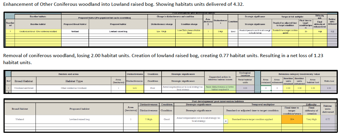
Scenario testing: Conversion of Coniferous Woodland to a Raised bog: Enhancement versus creation
Enhancement of Other Coniferous woodland into Lowland raised bog. Showing habitats units delivered of 4.32.
Removal of coniferous woodland, losing 2.00 habitat units. Creation of lowland raised bog, creating 0.77 habitat units. Resulting in a net loss of 1.23 habitat units.
Correspondence tables: EUNIS, UK Hab and Metric 3.1 habitat classifications
| EUNIS Level 2 |
EUNIS Level 3 |
EUNIS Level 4 |
EUNIS Level 5 |
EUNIS Level 6 |
UK Hab code |
DEFRA Biodiversity Metric habitat |
|---|---|---|---|---|---|---|
| E1 Dry Grassland (~1000 Ha) |
G1 and g2 |
Lowland dry acid grassland Upland acid grassland Bracken Upland calcareous grassland Lowland calcareous grassland |
||||
| E1.2 Perennial calcareous grassland and basic steppes |
G2 |
Lowland Calcareous grassland |
||||
| E1.26 Sub-Atlantic semi-dry calcareous grassland (CG2 CG7 CG10*) [H6210] |
G2a5 or gsb7 |
Lowland Calcareous grassland |
||||
| E1.7 Closed non-Mediterranean dry acid and neutral grassland |
g1a or g1b |
Lowland dry acid grassland Upland dry acid grassland |
||||
| E1.71 Nardus stricta swards (U5*) |
g1b6 |
Upland dry acid grassland |
||||
| E1.72 Agrostis - Festuca grassland |
g1a or g1b |
Lowland dry acid grassland Upland dry acid grassland |
||||
| E1.72# Species-rich Nardus grassland, on siliceous substrates in mountain areas (CG10* CG11 U4c U5c) [H6230] |
G2b6 |
Upland calcareous grassland |
||||
| E1.72x Other Agrostis - Festuca grassland (U4* CG10*) |
G2b or g1b or g1a |
Upland calcareous grassland Upland acid grassland Lowland dry acid grassland |
||||
| E1.73 Deschampsia flexuosa grassland (U2) |
G1b6 |
Upland acid grassland |
||||
| E1.9 Open non-Mediterranean dry acid and neutral grassland, including inland dune grassland |
g1a |
Lowland dry acid grassland |
||||
| E1.92 Perennial open siliceous grassland (U1*) |
g1a6 |
Lowland dry acid grassland |
||||
| E1.B Heavy-metal grassland |
s1c |
Sparsely vegetated land – Calaminarian grassland |
||||
| E1.B1 Atlantic heavy-metal grassland (CG10* CG13* OV37 non-NVC) [H6130] |
s1c5 |
Sparsely vegetated land – Calaminarian grassland |
||||
| E2 Mesic grasslands (~1179000 Ha) |
g1 or g2 or g3 or g4 |
Acid grassland Calcareous grassland Neutral grassland Modified grassland |
||||
| E2.1 Permanent mesotrophic pastures and aftermath-grazed meadows |
g1 or g2 or g3 or g4 |
Acid grassland Calcareous grassland Neutral grassland Modified grassland |
||||
| E2.11 Unbroken pastures (MG5 MG6*) |
g1 or g2 or g3 or g4 |
Acid grassland Calcareous grassland Neutral grassland Modified grassland |
||||
| E2.111 Ryegrass pastures (MG6*) |
G4 |
Modified grassland |
||||
| E2.112 Atlantic Cynosurus-Centaurea pastures (MG5) |
G3c6 |
Other neutral grassland |
||||
| E2.12 Ditch-broken pastures (MG6*) |
g3c5 secondary code 25 |
Other neutral grassland |
||||
| E2.13 Abandoned pastures (non-NVC) |
g3c5 or g3c8 |
Other neutral grassland |
||||
| E2.2 Low and medium altitude hay meadows |
g3 |
Neutral grassland |
||||
| E2.21 Atlantic hay meadows (MG1 MG2) |
g3c (g3c5 if Arrhenatherum dominated) |
Other neutral grassland |
||||
| E2.24 Boreal and sub-boreal meadows (MG3) [H6520] |
g3c |
Other neutral grassland |
||||
| E2.6 Agriculturally-improved, re-seeded and heavily fertilised grassland, including sports fields and grass lawns (MG7) |
g4 or c1b |
Modified grassland Cropland – Temporary grass and clover leys |
||||
| E2.8 Trampled mesophilous grasslands with annuals (OV12, OV19-23) |
secondary code 17 |
Sparsely vegetated land – Ruderal/Ephemeral |
||||
| E3 -Seasonally wet and wet grasslands |
secondary code 119 |
|||||
| E3.4 Moist or wet eutrophic and mesotrophic grassland |
g3 or g4 119 |
Neutral grassland Modified grassland |
||||
| E3.41 Atlantic and sub-Atlantic humid meadows (M22 M23b MG8 MG9) |
g3c8 14 15 |
Other neutral grassland |
||||
| E3.42 Juncus acutiflorus meadows (M23a) |
g3c8 14 15 |
Other neutral grassland |
||||
| E3.44 Flood swards and related communities (MG10-13 OV28) |
g3c8 14 15 |
Other neutral grassland |
||||
| E3.5 Moist or wet oligotrophic grassland |
||||||
| E3.51 Molinia caerulea meadows and related communities |
f2b |
Wetland – Purple moor grass and rush pasture |
||||
| E3.511 Calcicline purple moorgrass meadows (M26) [H6410] |
f2b5 |
Wetland – Purple moor grass and rush pasture |
||||
| -E3.512 Acidocline purple moorgrass meadows (M25*) |
g1b6 |
Upland acid grassland |
||||
| E3.52 Heath Juncus meadows and humid Nardus stricta swards (U5b U6) |
g1b6 |
Upland acid grassland |
||||
| E4 Alpine and subalpine grassland (~531000 Ha) |
g |
Grassland |
||||
| E4.1 Vegetated snow-patch |
secondary code 126 |
|||||
| E4.11 Boreo-alpine acidocline snow-patch grassland and herb habitats |
g1b secondary code 126 |
Upland acid grassland |
||||
| E4.115 Boreal moss snowbed communities |
g1b secondary code 126 176 |
Upland acid grassland |
||||
| E4.115# Polytrichastrum- Kiaeria snowbed (U11) [H6150*] |
g1b5 |
Upland acid grassland |
||||
| E4.115x Rhytidiadelphus-Deschampsia snowbed (U13b) |
g1b6 secondary code 126 176 |
Upland acid grassland |
||||
| E4.116 Boreo-alpine Deschampsia- Anthoxanthum communities (U13a) |
g1b6 secondary code 126 |
Upland acid grassland |
||||
| E4.117 Boreo-alpine herb-rich acid snowbed communities (U14) [H6150*] |
g1b5 secondary code126 |
Upland acid grassland |
||||
| E4.12 Boreo-alpine calcicline snow-patch grassland and herb habitats (CG12) [H6170*] |
g2b5 secondary code 126 |
Upland calcareous grassland |
||||
| E4.12€ Alpine and subalpine calcareous grasslands (CG12 CG13* CG14) (includes E4.12, F2.29#1) [H6170] |
g2b5 secondary code 126 |
Upland calcareous grassland |
||||
| E4.14 Boreo-alpine fern snowbed grassland (U18*) [H8110*] |
s1a5 |
Sparsely vegetated land – Inland rock outcrop and scree habitats |
||||
| E4.2 Moss and lichen dominated mountain summits, ridges and exposed slopes |
||||||
| E4.21 Oroboreal Carex bigelowii-Racomitrium moss-heaths (U9-10) [H6150*] |
g1b5 secondary code 176 |
Upland acid grassland |
||||
| E4.22 Rock pavement lichen communities (non-NVC) |
s1a or s1b or s1c or s1d |
Sparsely vegetated land - Inland rock outcrop and scree habitats Sparsely vegetated land - Limestone pavement Sparsely vegetated land - Calaminarian grasslands Sparsely vegetated land - Other inland rock and scree |
||||
| E4.23 Rock pavement, plateau and summital moss heaths (non-NVC) |
s1a or s1b or s1c or s1d secondary code 175 |
Sparsely vegetated land - Inland rock outcrop and scree habitats Sparsely vegetated land - Limestone pavement Sparsely vegetated land - Calaminarian grasslands Sparsely vegetated land - Other inland rock and scree |
||||
| E4.3 Acid alpine and subalpine grassland |
g1b |
Upland acid grassland |
||||
| E4.32 Oroboreal acidocline grassland (U7-8) [H6150*] |
g1b5 |
Upland acid grassland |
||||
| E4.32€ Siliceous alpine and boreal grasslands (U7-12 U14) (includes E4.115#, E4.117, E4.21, E4.32, F2.11) [H6150] |
g1b5 |
Upland acid grassland |
||||
| E5 Woodland fringes and clearings and tall forb stands (79000 Ha) |
secondary code 16 and/or 165 |
|||||
| E5.1 Anthropogenic herb stands |
c1 or u1a secondary code 17 |
Cropland Urban - Open Mosaic Habitats on Previously Developed Land |
||||
| E5.2 Thermophile woodland fringes |
||||||
| E5.22 Mesophile fringes (non-NVC) |
g1 or g2 or g3 |
Acid grassland Calcareous grassland Neutral grassland |
||||
| E5.3 Pteridium aquilinum fields |
g1c |
Grassland - Bracken |
||||
| E5.31 Sub-Atlantic Pteridium aquilinum fields (U20 W25*) |
g1c |
Grassland - Bracken |
||||
| E5.4 Moist or wet tall-herb and fern fringes and meadows |
f2 |
Wetland |
||||
| E5.41 Screens or veils of perennial tall herbs lining watercourses (non-NVC) |
f2d secondary code 16 or 17, 48 (for non-native) |
Wetland Sparsely vegetated land - Ruderal/Ephemeral |
||||
| E5.42 Tall-herb communities of humid meadows (M27 M28) |
f2 or g1 with secondary codes 14 or 15, 16 or 17 150, 178-181, or t2a7 for upper saltmarsh |
Wetland Acid grassland Sparsely vegetated land - Ruderal/Ephemeral |
||||
| E5.5 Subalpine moist or wet tall-herb and fern stands |
||||||
| E5.59 Oro-boreal tall-herb communities (U17) [H6430] |
s1a9 |
Grassland - Tall herb communities (H6430) |
||||
| E5.5B Alpine and subalpine fern stands (U19 non-NVC) |
g1b secondary codes 16, 120 |
Upland acid grassland |
||||
| E5.5x Luzula sylvatica-Vaccinium myrtillus tall-herb community (U16) |
g1b secondary codes 15, 156, |
Upland acid grassland |
||||
| EUNIS Level 2 |
EUNIS Level 3 |
EUNIS Level 4 |
EUNIS Level 5 |
EUNIS Level 6 |
UK Hab code |
Biodiversity Metric habitat |
|
|---|---|---|---|---|---|---|---|
| B1 Coastal dunes and sandy shores |
s3 |
Sparsely vegetated land - Coastal sand dunes Sparsely vegetated land - Coastal vegetated shingle |
|||||
| B1.1 Sand beach driftlines |
s3a |
Sparsely vegetated land - Coastal sand dunes |
|||||
| B1.12 Middle European sand beach annual communities (SD2* non-NVC) |
S3a |
Sparsely vegetated land - Coastal sand dunes |
|||||
| B1.2 Sand beaches above the driftline |
T2h |
||||||
| B1.21 Unvegetated sand beaches above the driftline |
T2h |
||||||
| B1.23 Boreo-arctic sand beach perennial communities (SD5*) |
T2h |
||||||
| B1.3 Shifting coastal dunes |
S3a |
Sparsely vegetated land - Coastal sand dunes |
|||||
| B1.31 Embryonic shifting dunes (SD2* SD4 SD5*) [H2110] |
S3a5 |
Sparsely vegetated land - Coastal sand dunes |
|||||
| B1.32 White dunes (SD5* SD6) [H2120] |
S3a6 |
Sparsely vegetated land - Coastal sand dunes |
|||||
| B1.4 Coastal stable dune grassland (grey dunes) |
S3a |
Sparsely vegetated land - Coastal sand dunes |
|||||
| B1.41 Northern fixed grey dunes (SD7-8 SD9* SD10-12 CG10*) [H2130*] |
S3a7 |
Sparsely vegetated land - Coastal sand dunes |
|||||
| B1.41€ Fixed dunes with herbaceous vegetation (`grey dunes`) (SD7 SD8 SD9* SD10-12 SD19 CG10*) (includes B1.41, B1.47) [H2130] |
S3a7 |
Sparsely vegetated land - Coastal sand dunes |
|||||
| B1.47 Dune fine-grass annual communities (SD19) [H2130*] |
S3a7 |
Sparsely vegetated land - Coastal sand dunes |
|||||
| B1.4x Species-poor Ammophila-Arrhenatherum dune grassland (SD9* non-NVC) |
S3a |
Sparsely vegetated land - Coastal sand dunes |
|||||
| B1.5 Coastal dune heaths |
S3a |
Sparsely vegetated land - Coastal sand dunes |
|||||
| B1.51 Empetrum brown dunes (H11b) [H2140] |
S3a8 |
Sparsely vegetated land - Coastal sand dunes |
|||||
| B1.52 Calluna vulgaris brown dunes (H11a/c H10) [H2150] |
S3a9 |
Sparsely vegetated land - Coastal sand dunes |
|||||
| B1.6 Coastal dune scrub |
s3a secondary code10 |
Sparsely vegetated land - Coastal sand dunes |
|||||
| B1.61 Coastal dune thickets (SD18, W23*) |
s3a secondary code10 |
Sparsely vegetated land - Coastal sand dunes |
|||||
| B1.62 Salix arenaria mats (SD16* SD12*) [H2170] |
s3a7 secondary code 28 |
Sparsely vegetated land - Coastal sand dunes |
|||||
| B1.63 Dune Juniperus thickets (non-NVC) [H2250] |
s3a4 |
Sparsely vegetated land - Coastal sand dunes |
|||||
| B1.8 Moist and wet dune slacks (includes B1.81-B1.86) [H2190] |
s3a3 |
Sparsely vegetated land - Coastal sand dunes |
|||||
| B1.81 Dune-slack pools (A10* A11* A13* A16* A22* other) [H2190*] |
s3a3 |
Sparsely vegetated land - Coastal sand dunes |
|||||
| B1.82 Dune-slack pioneer swards (SD13) [H2190*] |
s3a3 |
Sparsely vegetated land - Coastal sand dunes |
|||||
| B1.83 Dune-slack fens (SD14-15 non-NVC) [H2190*] |
s3a3 |
Sparsely vegetated land - Coastal sand dunes |
|||||
| B1.84 Dune-slack grassland and heaths (SD16* SD17) [H2190*] |
s3a3 |
Sparsely vegetated land - Coastal sand dunes |
|||||
| B1.85 Dune-slack reedbeds, sedgebeds and canebeds (S4* S19* other) [H2190*] |
s3a3 or f2e secondary code 138 |
Sparsely vegetated land - Coastal sand dunes Wetland - Reedbeds |
|||||
| B1.86 Coastal dunes: wet dune slacks: dominated by shrubs or trees (W1* W2* W4* W6*) [H2190*] |
s3a3 secondary code 10 or 11 |
Sparsely vegetated land - Coastal sand dunes |
|||||
| B1.9 Machair (SD8* SD17* MG11* OV4* non-NVC) [H21A0] |
secondary code 26 |
||||||
| B2 Coastal shingle |
s3b |
Sparsely vegetated land - Coastal vegetated shingle |
|||||
| B2.1 Shingle beach driftlines |
s3b |
Sparsely vegetated land - Coastal vegetated shingle |
|||||
| B2.12 Atlantic and Baltic shingle beach drift lines (SD2* SD3* MC6* non-NVC) [H1210] |
s3b6 |
Sparsely vegetated land - Coastal vegetated shingle |
|||||
| B2.2 Unvegetated mobile shingle beaches above the driftline |
s3 |
Sparsely vegetated land - Coastal sand dunes Sparsely vegetated land - Coastal vegetated shingle |
|||||
| B2.3 Upper shingle beaches with open vegetation (SD1 SD3* non-NVC) [H1220*] |
S3b5 |
Sparsely vegetated land - Coastal vegetated shingle |
|||||
| B2.4 Fixed shingle beaches, with herbaceous vegetation |
Sb3 |
Sparsely vegetated land - Coastal vegetated shingle |
|||||
| B2.41 Euro-Siberian gravel bank grasslands (MG1* non-NVC) [H1220*] |
s3b5 |
Sparsely vegetated land - Coastal vegetated shingle |
|||||
| B2.4# Other herbaceous vegetation of fixed coastal shingle (CG10* MC5* MC8* MC9* U1* U4* U20* non-NVC) [H1220*] |
s3b5 |
Sparsely vegetated land - Coastal vegetated shingle |
|||||
| B2.4€ Perennial vegetation of stony banks (see component types) (includes B2.3, B2.4, B2.5, B2.6) [H1220] |
s3b5 |
Sparsely vegetated land - Coastal vegetated shingle |
|||||
| B2.5 Shingle and gravel beaches with scrub (H10* W22* W23* W24* other) [H1220*] |
s3b5 secondary code 10 |
Sparsely vegetated land - Coastal vegetated shingle |
|||||
| B2.6 Shingle and gravel beach woodland (W1* W9* W11* non-NVC) [H1220*] |
s3b5 secondary code 10 or 11 |
Sparsely vegetated land - Coastal vegetated shingle |
|||||
| B3 Rock cliffs, ledges and shores, including the supralittoral |
s2 |
Sparsely vegetated land - Maritime cliff and slopes |
|||||
| B3.1 Supralittoral rock (lichen or splash zone) |
t1e |
||||||
| B3.2 Unvegetated rock cliffs, ledges, shores and islets |
s2 |
Sparsely vegetated land - Maritime cliff and slopes |
|||||
| B3.3 Rock cliffs, ledges and shores, with angiosperms |
s2a |
Sparsely vegetated land - Maritime cliff and slopes |
|||||
| B3.31 Atlantic sea-cliff communities (MC1-3 MC5 MC6* MC7-10 MC12 H7 H8* H10* CG10* MG1* U20* W21* W22* W23* W24* W25* other) [H1230*] |
s2a5 |
Sparsely vegetated land - Maritime cliff and slopes |
|||||
| B3.31€ Vegetated sea cliffs of the Atlantic and Baltic coasts (various) (includes B3.31, B3.4) [H1230] |
s2a5 |
Sparsely vegetated land - Maritime cliff and slopes |
|||||
| B3.4 Soft sea-cliffs, often vegetated (various) [H1230*] |
s2a6 |
Sparsely vegetated land - Maritime cliff and slopes |
|||||
| EUNIS Level 2 |
EUNIS Level 3 |
EUNIS Level 4 |
EUNIS Level 5 |
EUNIS Level 6 |
UKHab code |
DEFRA Biodiversity Metric Definition |
|---|---|---|---|---|---|---|
| D1 Raised and Blanket bogs |
F1 |
|||||
| D1.1 Raised bogs |
F1b |
Wetland - Lowland raised bog |
||||
| D1.11 Active, relatively undamaged raised bogs (M18* M19* M1* M2*) [H7110] |
F1b |
Wetland - Lowland raised bog |
||||
| D1.12 Damaged, inactive bogs |
F1b5 |
Wetland - Lowland raised bog |
||||
| D1.12# Degraded raised bogs still capable of natural regeneration (M3* M15* M16* M17* M18* M19* M20* M25* other) [H7120] |
F1b6 |
Wetland - Lowland raised bog |
||||
| D1.12x Damaged, inactive bogs not capable of restoration within 30 years (various) |
F1b7 |
Wetland - Lowland raised bog |
||||
| D1.2 Blanket bogs (includes D1.21, D1.22, D1.24) [H7130] |
F1a |
Wetland - Blanket bog |
||||
| D1.21 Hyperoceanic low-altitude blanket bogs, typically with dominant Trichophorum (M1* M2* M3* M15* M17* M18* M25*) [H7130*] |
F1a5 |
Wetland - Blanket bog |
||||
| D1.22 Montane blanket bogs, Calluna and Eriophorum vaginatum often dominant (M1* M2* M3* M15* M19* M20*) [H7130*] |
f1a5 secondary code 13 |
Wetland - Blanket bog |
||||
| D1.24 Wet bare peat and peat haggs on blanket bogs [H7130*] |
f1a5 secondary code 127 or 85 where peat has been cut |
Wetland - Blanket bog |
||||
| D2 Valley mires, poor fens and transition mires |
f2a f2c |
Wetland - Fens (upland and lowland) |
||||
| D2.1 Valley mires |
f2a f2c secondary code 187 |
Wetland - Fens (upland and lowland) |
||||
| D2.11 Acid valley mires (M21) |
f2a f2c secondary code 187 |
Wetland - Fens (upland and lowland) |
||||
| D2.2 Poor fens and soft-water spring mires |
f2a f2c secondary codes 183 or 184 or185 |
Wetland - Fens (upland and lowland) |
||||
| D2.22 Carex nigra, Carex canescens, Carex echinata fens (M6-7) |
f2f secondary code 186 |
|||||
| D2.2C Soft water spring mires (M31-33 M35-36) |
f2f secondary code 186 |
|||||
| D2.3 Transition mires and quaking bogs |
f2a8 or f2c8 |
Wetland - Fens (upland and lowland) |
||||
| D2.31 Carex lasiocarpa swards (M4* M5* M9*) [H7140*] |
f2a8 or f2c8 secondary code 178 and 179 or 180 and 187 |
Wetland - Transition mires and quaking bogs (H7140) |
||||
| D2.3 Transition mires and quaking bogs D2.31 Carex lasiocarpa swards (M4* M5* M9*) [H7140*] D2.32 Carex diandra quaking mires (M9*) [H7140*] |
f2a8 or f2c8 secondary code 178 and 179 or 180 and 188 |
Wetland - Transition mires and quaking bogs (H7140) |
||||
| D2.33 Carex rostrata quaking mires (M4* M5* M8 M9*) [H7140*] |
f2a8 or f2c8 secondary code 179 or 181 |
Wetland - Transition mires and quaking bogs (H7140) |
||||
| D2.33€ Transition mires and quaking bogs (Annex I) (includes D2.31-33, D2.39, D2.3#) [H7140] |
f2a8 or f2c8 secondary code 178 and 179 or 180 and 188 |
Wetland - Transition mires and quaking bogs (H7140) |
||||
| D2.37 Rhynchospora alba quaking bogs (M1* M2*) [H7150] |
f2a8 or f2c8 secondary code 24 |
Wetland - Transition mires and quaking bogs (H7140) |
||||
| D2.39 Menyanthes trifoliata and Potentilla palustris rafts (S27 non-NVC) [H7140*] |
f2a8 or f2c8 secondary code 178 and 179 or 180 or 181 or 182 and 186 |
Wetland - Transition mires and quaking bogs (H7140) |
||||
| D2.3# Hypericum elodes-Potamogeton polygonifolius soakway (M29*) [H7140*] |
f2a8 or f2c8 secondary code 178 and 179 or 180 and 186 |
Wetland - Transition mires and quaking bogs (H7140) |
||||
| D4 Base-rich fens and calcareous spring mires |
f2a or f2c |
Wetland - Fens (upland and lowland) |
||||
| D4.1 Rich fens, including eutrophic tall-herb fens and calcareous flushes and soaks |
f2a or f2c |
Wetland - Fens (upland and lowland) |
||||
| D4.12 Schoenus ferrugineus fens (M10*) [H7230*] |
f2a7 or f2c7 secondary code 14 or 15 and 169 and 175 |
Wetland - Fens (upland and lowland) |
||||
| D4.15 Carex dioica, Carex pulicaris and Carex flava fens (M10*) [H7230*] |
f2a7 or f2c7 secondary code 14 or 15 and (169 and 175) or (171 and 183) or 184 |
Wetland - Fens (upland and lowland) |
||||
| D4.15€ Alkaline fens (includes D4.12, D4.15, D4.19, D4.1C) [H7230] |
f2a7 or f2c7 secondary code 171 |
Wetland - Fens (upland and lowland) |
||||
| D4.17 Carex saxatilis fens (M12) [H7240*] |
f2c5 secondary code 14 or 15 |
|||||
| D4.19 British Carex demissa - Saxifraga aizoides flushes (M11*) [H7230*] |
f2a7 or f2c7 secondary codes 14 or 15 and 171 and 186 |
Wetland - Fens (upland and lowland) |
||||
| D4.1C Carex rostrata alkaline fens (M9*) [H7230*] |
f2a7 or f2c7 secondary code 14 or 15 and 171 and 186 or 183 |
Wetland - Fens (upland and lowland) |
||||
| D4.1I Tall herb fens (S25*) |
f2a or f2c 16 secondary code 174 |
Wetland - Fens (upland and lowland) |
||||
| D4.1N Hard water spring mires (M37 M38) [H7220] |
f2a6 or f2c6 |
Wetland - Fens (upland and lowland) |
||||
| D4.2 Basic mountain flushes and streamsides, with a rich arctic-montane flora |
f2c |
|||||
| D4.24 British mica flushes (M10* M11* M34) [H7240*] |
f2c5 |
|||||
| D4.24€ Alpine pioneer formations of the Caricion bicoloris-atrofuscae (M10* M11* M12 M34) (includes D4.17, D4.24) [H7240] |
f2c5 |
|||||
| EUNIS Level 2 |
EUNIS Level 3 |
EUNIS Level 4 |
EUNIS Level 5 |
EUNIS Level 6 |
UK Hab code |
DEFRA Biodiversity Metric habitat |
|---|---|---|---|---|---|---|
| F2 Artic, alpine and subalpine scrub |
h1c |
Heathland and shrub - Mountain heaths and willow scrub |
||||
| F2.1 Subarctic and alpine dwarf willow scrub |
h1c5 |
Heathland and shrub - Mountain heaths and willow scrub |
||||
| F2.11 Boreo-alpine acidocline snow-patch Salix herbacea scrub (U12) [H6150*] |
g1b5 |
Grassland - Upland acid grassland |
||||
| F2.1# Sub-Arctic Salix spp. scrub (W20) [H4080] |
h1c6 |
Heathland and shrub - Mountain heaths and willow scrub |
||||
| F2.2 Evergreen alpine and subalpine heath and scrub |
h1c |
Heathland and shrub - Mountain heaths and willow scrub |
||||
| F2.25 Boreo-alpine and arctic heaths (H10* H12* H13-15 H16* H17 H18* H19-20 H21* H22*) [H4060] |
h1c5 |
Heathland and shrub - Mountain heaths and willow scrub |
||||
| F2.29 Dryas octopetala mats |
||||||
| F2.29#1 Dryas mats not on limestone pavement (CG13* CG14) [H6170*] |
g2b5 |
Grassland - Upland calcareous grassland |
||||
| F2.29#2 Dryas mats on limestone pavement (CG13*) [H8240*] |
s1b5 |
Sparsely vegetated land - Limestone pavement |
||||
| F2.3 Subalpine deciduous scrub |
h1c |
Heathland and shrub - Mountain heaths and willow scrub |
||||
| F2.32 Subalpine and oroboreal Salix brush |
h1c |
Heathland and shrub - Mountain heaths and willow scrub |
||||
| F2.323 Northern British willow brush (non-NVC) |
w1h5 secondary code 37 |
Woodland and forest - Other woodland; mixed |
||||
| F3 Temperate and Mediterranean – montane scrub |
||||||
| F3.1 Temperate thickets and scrub |
||||||
| F3.11 Medio-European rich-soil thickets (W21* W22*) |
h3d, s3a7 secondary code 10 |
Heathland and shrub - Bramble scrub Sparsely vegetated land - Coastal sand dunes |
||||
| F3.13 Atlantic poor soil thickets (W24* W25*) |
h3d |
Heathland and shrub - Bramble scrub |
||||
| F3.14 Temperate Cytisus scoparius fields (W23*) |
h3e |
Heathland and shrub - Gorse scrub |
||||
| F3.15 Ulex europaeus thickets (W23*) |
h3e |
Heathland and shrub - Gorse scrub |
||||
| F3.16 Juniperus communis scrub |
secondary code 22 |
|||||
| F3.16#1 Juniperus communis formations on heaths or calcareous grasslands (W19*) [H5130] |
g2a or h1a secondary code 22 |
Grassland - Lowland calcareous grassland Heathland and shrub - Lowland Heathland |
||||
| F3.16#2 Juniperus communis scrub in native pinewoods (W19*) [H91C0*] |
w2a5 |
Woodland and forest - Native pine woodlands |
||||
| F3.17 Corylus thickets |
h3b6 |
Heathland and shrub - Hazel scrub |
||||
| F3.17#1 Corylus thickets on calcareous rocky slopes (W9*) [H9180*] |
w1b5 |
Woodland and forest - Upland mixed ashwoods |
||||
| F3.17#2 Corylus thickets on limestone pavement (W9*) [H8240*] |
s1b5 secondary code 10 |
Sparsely vegetated land - Limestone pavement |
||||
| F3.17x Corylus thickets not on calcareous rocks (W11*) |
h3b6 |
Heathland and shrub - Hazel scrub |
||||
| F4 Temperate shrub heathland |
h1 |
|||||
| F4.1 Wet heaths |
h1a or h1b |
Heathland and shrub - Lowland Heathland Heathland and shrub - Upland Heathland |
||||
| F4.11 Northern wet heaths (M15* M16*) [H4010] |
h1a7 or h1b6 |
Heathland and shrub - Lowland Heathland Heathland and shrub - Upland Heathland |
||||
| F4.13 Molinia caerulea wet heaths (M25*) |
f2b or g1 (secondary codes 14 or 15) |
Wetland - Purple moor grass and rush pastures |
||||
| F4.2 Dry heaths (includes F4.21-F4.25) [H4030] |
h1a5 or h1b5 or s2a (coastal) |
Heathland and shrub - Lowland Heathland Heathland and shrub - Upland Heathland Sparsely vegetated land - Inland rock outcrop and scree habitats |
||||
| F4.21 Submontane Vaccinium - Calluna heaths (H12* H18* H21* H22*) [H4030*] |
h1a5 |
Heathland and shrub - Lowland Heathland |
||||
| F4.22 Sub-Atlantic Calluna - Genista heaths (H9 H16*) [H4030*] |
h1a5 |
Heathland and shrub - Lowland Heathland |
||||
| F4.23 Atlantic Erica – Ulex heaths (H8*) [H4030*] |
h1a5 |
Heathland and shrub - Lowland Heathland |
||||
| F4.25 Boreo-Atlantic Erica cinerea heaths (H7* H10*) [H4030*] |
h1a5 |
Heathland and shrub - Lowland Heathland |
||||
| F9 Riverine and fen scrubs |
||||||
| F9.2 Salix carr and fen scrub |
w1d |
Woodland and forest - Wet woodland |
||||
| F9.21 Grey willow carrs (W1 W2* W3* W5*) |
w1d |
Woodland and forest - Wet woodland |
||||
| F9.22 Sphagnum willow carrs (W4*) |
w1d |
Woodland and forest - Wet woodland |
||||
| F9.23 Bay willow carrs (W3*) |
w1d |
Woodland and forest - Wet woodland |
||||
| F9.3 Southern riparian galleries and thickets |
g3 secondary codes 16 or 17, 48 |
Neutral grassland |
||||
| F9.35 Riparian stands of invasive shrubs (non-NVC) |
||||||
| EUNIS Level 2 |
EUNIS Level 3 |
EUNIS Level 4 |
EUNIS Level 5 |
EUNIS Level 6 |
UK Hab code |
DEFRA Biodiversity Metric habitat |
|---|---|---|---|---|---|---|
| G1 Broadleaved deciduous woodland |
w1 |
|||||
| G1.1 Riparian and gallery woodland, with dominant Alnus, Betula, Populus or Salix |
w1d |
Woodland and forest - Wet woodland |
||||
| G1.11 Riverine Salix woodland (W6*) [H91E0*] |
w1d5 |
Woodland and forest - Wet woodland |
||||
| G1.2 Mixed riparian floodplain and gallery woodland |
w1d |
Woodland and forest - Wet woodland |
||||
| G1.21 Riverine Fraxinus - Alnus woodland, wet at high but not at low water (W2* W5* W6* W7*) [H91E0*] |
w1d5 secondary code 119 |
Woodland and forest - Wet woodland |
||||
| G1.21€ Alluvial forests with Alnus glutinosa and Fraxinus excelsior (Alno-Padion, Alnion incanae, Salicion albae) (W2* W5* W6* W7*) (includes G1.11, G1.21) [H91E0] |
w1d5 |
Woodland and forest - Wet woodland |
||||
| G1.4 Broadleaved swamp woodland not on acid peat |
||||||
| G1.41 Alnus swamp woods not on acid peat (W2* W3* W5* W6* W7*) |
w1d |
Woodland and forest - Wet woodland |
||||
| G1.5 Broadleaved swamp woodland on acid peat |
||||||
| G1.51 Sphagnum Betula woods |
w1d secondary codes 163, 127 |
Woodland and forest - Wet woodland |
||||
| G1.51# Birch bog woodland (W4* M17* M18*) [H91D0*] |
w1d6 |
Woodland and forest - Wet woodland |
||||
| G1.51x Other sphagnum Betula woods (W2* W4*) |
w1d secondary codes 163, 127 |
Woodland and forest - Wet woodland |
||||
| G1.52 Alnus swamp woods on acid peat (W4*) |
w1d secondary code 127 |
Woodland and forest - Wet woodland |
||||
| G1.6 Fagus woodland |
w1c |
Woodland and forest - Lowland beech and yew woodland |
||||
| G1.62 Atlantic acidophilous Fagus forests (W15) |
w1c5 |
Woodland and forest - Lowland beech and yew woodland |
||||
| G1.8 Acidophilous Quercus-dominated woodland |
w1a |
Woodland and forest - Upland oakwood |
||||
| G1.81 Atlantic Quercus robur - Betula woods (W16*) |
w1a or w1f7 |
Woodland and forest - Upland oakwood |
||||
| G1.83 Atlantic Quercus petraea woods (W11* W17*) [H91A0*] |
w1a5 |
Woodland and forest - Upland oakwood |
||||
| G1.83€ Old sessile oak woods with Ilex and Blechnum in the British Isles (W11* W17*) (includes G1.83, G1.91#) [H91A0] |
w1a5 |
Woodland and forest - Upland oakwood |
||||
| G1.9 Non-riverine woodland with Betula, Populus tremula or Sorbus aucuparia |
W1f |
Woodland and forest - Lowland mixed deciduous woodland |
||||
| G1.91 Betula woodland not on marshy terrain |
w1f secondary code 119 or 120 |
Woodland and forest - Lowland mixed deciduous woodland |
||||
| G1.91#1 Atlantic Betula - Quercus petraea woodlands (W11* W17*) [H91A0*] |
w1a5 |
Woodland and forest - Upland oakwood |
||||
| G1.91#2 Betula woodland in native pinewoods (W11* W17*) [H91C0*] |
w2a5 |
Woodland and forest - Native pine woodlands |
||||
| G1.91x Other dry Betula woodlands (W10* W11* W16* W17*) |
w1e |
Woodland and forest - Upland birchwoods |
||||
| G1.92 Populus tremula woodland (W11*) |
w1g7 |
Woodland and forest - Other woodland; broadleaved |
||||
| G1.A Meso- and eutrophic Quercus, Carpinus, Fraxinus, Acer, Tilia, Ulmus and related woodland |
w1 |
|||||
| G1.A1 Quercus-Fraxinus-Carpinus betulus woodland on eutrophic and mesotrophic soils (W10*) |
w1f7 |
Woodland and forest - Lowland mixed deciduous woodland |
||||
| G1.A2 Non-riverine Fraxinus woodland |
w1 |
|||||
| G1.A2#1 Fraxinus woodland of slopes, screes and ravines (W7* W8* W9*) [H9180*] |
w1b5 |
Woodland and forest - Upland mixed ashwoods |
||||
| G1.A2#1€ Tilio-Acerion forests of slopes, screes and ravines (W7* W8* W9*) (includes F3.17#1, G1.A2#1) [H9180] |
w1b5 |
Woodland and forest - Upland mixed ashwoods |
||||
| G1.A2#2 Fraxinus woodland on limestone pavement (W9*) [H8240*] |
s1b5 secondary code 10 |
Sparsely vegetated land - Limestone pavement |
||||
| G1.A2x Other non-riverine Fraxinus woodland (W8*) |
w1b6 or w1f |
Woodland and forest - Upland mixed ashwoods Woodland and forest - Lowland mixed deciduous woodland |
||||
| G1.C Highly artificial broadleaved deciduous forestry plantations |
w1h secondary code 36 |
Woodland and forest - Other woodland; mixed |
||||
| G1.D Fruit and nut tree orchards |
c1 |
|||||
| G1.D4 Fruit orchards |
||||||
| G1.D4x1 Traditionally managed orchards |
g1 or g2 or g3 secondary code 21 |
|||||
| G1.D4x2 Intensively managed orchards |
c1d |
Cropland - Non-cereal crops |
||||
| G3 Coniferous woodland |
w2 |
|||||
| G3.4 Pinus sylvestris woodland south of the taiga |
w2a |
Woodland and forest - Native pine woodlands |
||||
| G3.41 Caledonian forest (W18*) [H91C0*] |
w2a5 |
Woodland and forest - Native pine woodlands |
||||
| G3.41€ Caledonian forest (Annex I) (W18* W19* W11* W17*) (includes F3.16#2, G1.91#2, G3.41) [H91C0] |
w2a5 |
Woodland and forest - Native pine woodlands |
||||
| G3.4F European Pinus sylvestris reforestation (W18*) |
w2b |
Woodland and forest - Other Scot's Pine woodland |
||||
| G3.D Boreal bog conifer woodland |
||||||
| G3.D1 Boreal Pinus sylvestris bog woods (W18* M18* M19*) [H91D0*] |
w1d6 secondary code 343 |
Woodland and forest - Wet woodland |
||||
| G3.D1€ Bog woodland (W4* W18* M17* M18* M19* other) (includes G1.51#, G3.D1) [H91D0] |
w1d6 secondary code 342 |
Woodland and forest - Wet woodland |
||||
| G3.F Highly artificial coniferous plantations |
w2c secondary code 36 |
Woodland and forest - Other coniferous woodland |
||||
| G3.F1 Native conifer plantations (W18*) |
w2c secondary codes 36 47 |
Woodland and forest - Other coniferous woodland |
||||
| G3.F2 Exotic conifer plantations (non-NVC types) |
w2c secondary codes 36 48 |
Woodland and forest - Other coniferous woodland |
||||
| G4 Mixed deciduous and coniferous woodland |
w1h |
Woodland and forest - Other woodland; mixed |
||||
| G4.F Mixed forestry plantations |
w1h5 or w1h6 secondary code 36 |
Woodland and forest - Other woodland; mixed |
||||
| G5 Lines of trees, small anthropogenic woodlands, recently felled woodland, earlystage woodland and coppice |
w |
|||||
| G5.1 Lines of trees |
w1g6 secondary code 341 or 342 or 343 and 47 and/or 48 |
Woodland and forest - Other woodland; broadleaved |
||||
| G5.7 Coppice and early-stage plantations |
coppice w1f or w1g or w1h secondary code 51 or 52: early stage lantations w1f w1g or w1h or w2c secondary code 56 |
Woodland and forest - Lowland mixed deciduous woodland Woodland and forest - Other woodland; broadleaved Woodland and forest - Other woodland; mixed |
||||
| G5.8 Recently felled areas |
w1f or w1g or w1h or w2c secondary code 53 |
Woodland and forest - Felled |
||||
| EUNIS Level 2 |
EUNIS Level 3 |
EUNIS Level 4 |
EUNIS Level 5 |
EUNIS Level 6 |
UK Hab code |
DEFRA Biodiversity Metric habitat |
|---|---|---|---|---|---|---|
| H1 Terrestrial underground caves, cave systems, passages and waterbodies |
overlying habitat with secondary code 23 |
|||||
| H1.1 Cave entrances |
Not included |
|||||
| H1.2 Cave interiors |
Not included |
|||||
| H1.3 Dark underground passages |
Not included |
|||||
| H1.5 Underground standing waterbodies |
Not included |
|||||
| H1.6 Underground running waterbodies |
Not included |
|||||
| H1.7 Disused underground mines and tunnels |
Not included |
|||||
| H2 Screes |
s1a |
Sparsely vegetated land - Inland rock outcrop and scree habitats |
||||
| H2.3 Temperate-montane acid siliceous screes |
s1a |
Sparsely vegetated land - Inland rock outcrop and scree habitats |
||||
| H2.31 Alpine siliceous screes (U21* non-NVC) [H8110*] |
s1a5 |
Sparsely vegetated land - Inland rock outcrop and scree habitats |
||||
| H2.31€ Siliceous scree of the montane to snow levels (Androsacetalia alpinae and Galeopsietalia ladani) (U18* U21* non-NVC) (includes E4.14, H2.31 and H5.11#1) [H8110] |
s1a5 |
Sparsely vegetated land - Inland rock outcrop and scree habitats |
||||
| H2.4 Temperate-montane calcareous and ultra-basic screes (OV38* OV40* non-NVC) [H8120*] |
s1a6 |
Sparsely vegetated land - Inland rock outcrop and scree habitats |
||||
| H2.4€ Calcareous and calcshist screes of the montane to alpine levels (Thlaspietea rotundifolii) (OV38* OV40* non-NVC) (includes H2.41 and H5.11#2) [H8120] |
s1a6 |
Sparsely vegetated land - Inland rock outcrop and scree habitats |
||||
| H3 Inland cliffs, rock pavements and outcrops |
s1 |
|||||
| H3.1 Acid siliceous inland cliffs |
s1a |
Sparsely vegetated land - Inland rock outcrop and scree habitats |
||||
| H3.1# Siliceous rocky slopes with chasmophytic vegetation (U18* U21* non-NVC) [H8220] |
s1a8 |
Sparsely vegetated land - Inland rock outcrop and scree habitats |
||||
| H3.1C Disused siliceous quarries |
s1a secondary code 105 and 135 |
Sparsely vegetated land - Inland rock outcrop and scree habitats |
||||
| H3.2 Basic and ultra-basic inland cliffs |
s1a |
Sparsely vegetated land - Inland rock outcrop and scree habitats |
||||
| H3.25 Alpine and sub-mediterranean chasmophyte communities (OV39* OV40* nonNVC) [H8210] |
s1a7 |
Sparsely vegetated land - Inland rock outcrop and scree habitats |
||||
| H3.4 Wet inland cliffs |
s1 |
|||||
| H3.42 Northern wet inland cliffs (U15 non-NVC) |
s1 secondary code 120 |
|||||
| H3.5 Almost bare rock pavements, including limestone pavements |
||||||
| H3.51 Pavements, rock slabs, rock domes |
s1d |
|||||
| H3.511 Limestone pavements (OV38* OV39* OV40* CG10* non-NVC) [H8240*] |
s1b5 |
Sparsely vegetated land - Limestone pavement |
||||
| H3.511€ Limestone pavements (Annex I) (CG10* CG13* OV38* OV39* OV40* W9* non-NVC) (includes F2.29#2, F3.17#2, G1.A2#, H3.511) [H8240] |
s1b5 |
Sparsely vegetated land - Limestone pavement |
||||
| H3.51x Non-limestone rock slabs |
s1d secondary code 135 |
|||||
| H5 Miscellaneous inland habitat with very sparse or no vegetation |
s1 |
|||||
| H5.1 Fjell fields and other freeze-thaw features with very sparse or no vegetation |
s1a |
Sparsely vegetated land - Inland rock outcrop and scree habitats |
||||
| H5.11 Fjell fields with very sparse or no vegetation |
s1a |
Sparsely vegetated land - Inland rock outcrop and scree habitats |
||||
| H5.11#1 Acidic fell-fields (non-NVC) [H8110*] |
s1a5 |
Sparsely vegetated land - Inland rock outcrop and scree habitats |
||||
| H5.11#2 Basic fell-fields (non-NVC) [H8120*] |
s1a6 |
Sparsely vegetated land - Inland rock outcrop and scree habitats |
||||
| H5.3 Sparsely- or un-vegetated habitats on mineral substrates not resulting from recent ice activity |
for burnt secondary code 63 |
|||||
| H5.31 Clay and silt with very sparse or no vegetation |
s1 |
Sparsely vegetated land |
||||
| H5.35 Gravel with very sparse or no vegetation |
s1 secondary code 145 or 106 for quarried areas |
Sparsely vegetated land |
||||
| H5.36 Shallow rocky soils with very sparse or no vegetation |
s1 |
Sparsely vegetated land |
||||
| H5.37 Boulder fields |
s1d secondary code 135 |
Sparsely vegetated land |
||||
| H5.6 Trampled areas |
overlying habitat and secondary code 73 (and 58 for animals) |
|||||
| EUNIS Level 2 |
EUNIS Level 3 |
EUNIS Level 4 |
EUNIS Level 5 |
EUNIS Level 6 |
UK Hab code |
DEFRA Biodiversity Metric habitat |
|---|---|---|---|---|---|---|
| I1 Arable land and market gardens |
C1 |
|||||
| I1.1 Intensive unmixed crops |
c1b or c1c or c1d |
Cropland - Temporary grass and clover leys Cropland - Cereal crops Cropland - Non-cereal crops |
||||
| I1.2 Mixed crops of market gardens and horticulture |
c1f |
Cropland - Horticulture |
||||
| I1.3 Arable land with unmixed crops grown by low-intensity agricultural methods (OV1* OV3-4* OV7* OV9-10* OV13*) |
c1c or c1d7 |
Cropland - Cereal crops Cropland - Non-cereal crops |
||||
| I1.5 Bare tilled, fallow or recently abandoned arable land (OV1* OV3-4* OV7* OV9- 10* OV13*) |
c1c or c1c5 secondary code 77 or 78 or 80 or 34 or 43 or 74 |
Cropland - Cereal crops Cropland - Cereal crops winter stubble |
||||
| I2 Cultivated areas of gardens and parks |
u1d secondary code 200 or 210 or 211 or 212 or 213 or 214 or 215 or 230 or 231 |
|||||
| J1 Buildings of cities, towns and villages |
u1b5 |
Urban - Developed land; sealed surface |
||||
| J2 Low density buildings |
u1b5 or u1d |
Urban - Developed land; sealed surface |
||||
| J3 Extractive industrial sites |
s secondary code 100 or 101 or 105 or 106 |
|||||
| J4 Transport networks and other constructed hard surfaced areas |
u1e |
Urban - Built linear features |
||||
| J5 Highly artificial man-made waters and associated structures |
r1a or r1b or r1c secondary code 39 or 105 or 362 or r1e |
Lakes - Ponds (Non- Priority Habitat) |
||||
| J6 Waste deposits |
||||||
Intertidal habitats
| EUNIS Level 2 |
EUNIS Level 3 |
EUNIS Level 4 |
EUNIS Level 5 |
EUNIS Level 6 |
UK Hab code |
DEFRA Biodiversity Metric habitat |
|---|---|---|---|---|---|---|
| A2 Littoral sediment |
t2 |
|||||
| A2.5 Coastal saltmarshes |
t2a |
Coastal saltmarsh - Saltmarshes and saline reedbeds |
||||
| A2.51 Saltmarsh driftlines (SM27-28) |
t2a or t2a5 |
Coastal saltmarsh - Saltmarshes and saline reedbeds |
||||
| A2.52 Upper saltmarshes (SM23) |
t2a |
Coastal saltmarsh - Saltmarshes and saline reedbeds |
||||
| A2.53 Mid-upper saltmarshes (SM15-20) [H1330*] |
t2a7 |
Coastal saltmarsh - Saltmarshes and saline reedbeds |
||||
| A2.54 Low-mid saltmarshes (SM10 SM13-14) [H1330*] |
t2a7 secondary code 122 |
Coastal saltmarsh - Saltmarshes and saline reedbeds |
||||
| A2.54€ Atlantic salt meadows (Glauco-Puccinellietalia maritimae) (includes A2.53, A2.54, A2.556) [H1330] |
t2a7 |
Coastal saltmarsh - Saltmarshes and saline reedbeds |
||||
| A2.55 Pioneer saltmarshes |
t2a |
Coastal saltmarsh - Saltmarshes and saline reedbeds |
||||
| A2.551 Salicornia, Suaeda and Salsola pioneer saltmarshes (SM8-9) [H1310] |
t2a5 |
Coastal saltmarsh - Saltmarshes and saline reedbeds |
||||
| A2.554 Flat-leaved Spartina swards (SM5-6) |
t2a (t2a6 for Annex I 1320) |
Coastal saltmarsh - Saltmarshes and saline reedbeds |
||||
| A2.556 Rayed Aster tripolium pioneer saltmarshes (SM12) [H1330*] |
t2a7 |
Coastal saltmarsh - Saltmarshes and saline reedbeds |
||||
| A5 Sublittoral sediment |
||||||
| A5.5 Sublittoral macrophyte-dominated sediment |
||||||
| A5.54 Angiosperm communities in reduced salinity |
||||||
| A5.542 Association with Potamogeton pectinatus (A12*) [H1150*] |
t2g5 |
|||||
| A5.543 Vegetation of brackish waters dominated by Ranunculus baudotii (A21*) [H1150*] |
t2g5 |
|||||
Contact
Email: katherine.pollard@gov.scot