Scottish Fire and Rescue Service (SFRS) - wildfire: incident reporting system - data analyses
This report examines Incident Reporting System (IRS) data on wildland fire incidents and uses these to improve the understanding of how upland wildfires start, investigate if wildfire occurrence differs between geographical areas; and describe how wildfires exhibit seasonal and temporal trends.
7 Comparison with European wildfires
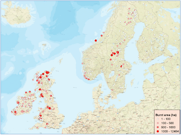
In this Section we compared wildfires that occurred in selected Northern European countries with similar bioclimatic conditions and land management practices to Scotland using available datasets of European coverage. For this reason, we obtained 733 polygons (in ESRI shapefile format) of burnt areas recorded by the European Forest Fire Information System (EFFIS; https://effis.jrc.ec.europa.eu/) from MODIS satellite imagery (areas >30ha) from 2014 to 2020 for Scotland (SCO) and the rest of the UK (England (ENG), Wales (WLS) and Northern Ireland (NIR)), the Republic of Ireland (IE), Norway (NO), Sweden (SE) and Finland (FI) (Figure 7.1).
The objective of this analysis was to investigate and compare the presence of a) seasonality; b) burnt area size; and c) fuel type patterns. Information on fire dates and size of burnt areas were available from the EFFIS burnt area polygons. Fuel type information was obtained from the EFFIS European Fuel type Map; we loaded the EFFIS burnt area polygons and the fuel type map on QGIS and calculated the areal proportions of fuel types within the burnt area perimeters along with the dominant (i.e., greater areal coverage) fuel type for each polygon.
Most fire/burnt area polygons were located in Scotland, the Republic of Ireland and Sweden (Figure 7.2a). With regards to the monthly distribution of fires for all countries studied, most fires occurred in April (n=224) followed by May (n=120), June (n=99) and July (n=93) (Figure 7.2b).
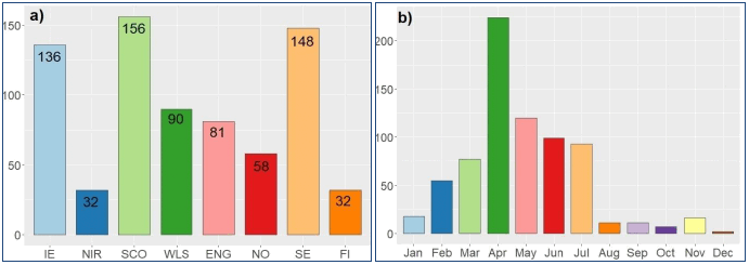
Fires occurring in spring (March to May) were the most frequent in Scotland, the Republic of Ireland, Wales, Northern Ireland, and Norway, while summer fires (June to August) were the most frequent in Sweden and Finland (Table 7.1). Spring fires were also dominant in England (33 out of 81 fires in total), however a relatively large proportion of the English fires occurred in January and February (22 fires). March was the month with the most recorded fires for Wales, April was for Scotland, the Republic of Ireland and Norway, May was for Northern Ireland, June for Finland, and July for Sweden.
| Country | IE | NIR | SCO | WLS | ENG | NO | SE | FI |
|---|---|---|---|---|---|---|---|---|
| January | 1 | 0 | 3 | 0 | 12 | 2 | 0 | 0 |
| February | 11 | 0 | 8 | 15 | 20 | 1 | 0 | 0 |
| March | 13 | 2 | 17 | 30 | 13 | 1 | 1 | 0 |
| April | 52 | 9 | 81 | 24 | 11 | 39 | 8 | 0 |
| May | 32 | 13 | 23 | 7 | 9 | 7 | 23 | 6 |
| June | 13 | 7 | 3 | 5 | 6 | 1 | 44 | 20 |
| July | 7 | 1 | 1 | 9 | 4 | 3 | 63 | 5 |
| August | 0 | 0 | 0 | 0 | 2 | 1 | 7 | 1 |
| September | 6 | 0 | 2 | 0 | 0 | 1 | 2 | 0 |
| October | 1 | 0 | 3 | 0 | 2 | 1 | 0 | 0 |
| November | 0 | 0 | 14 | 0 | 2 | 0 | 0 | 0 |
| December | 0 | 0 | 1 | 0 | 0 | 1 | 0 | 0 |
Median sizes of burnt areas were relatively similar for all studied countries, ranging from 18.5 ha in Finland to 79 ha in the Republic of Ireland (Table 7.2). The largest burnt area recorded in the dataset was for a summer (31/7/2014) fire in Sweden with a burnt area of 12,484 ha of mainly conifer forest, followed by a spring (13/05/2019) fire in Scotland that burned an area of 5,430 ha of mainly peatlands. There were 733 fires with burnt areas less than 100 ha, which accounted for 74% to 77% of fires in Northern Ireland, England and Sweden, for 60% to 67% of fires in Ireland, Scotland, Wales and Norway and for all fires in Finland. Regarding bigger fires, there were 25 fires with burnt areas more than 1,000 ha, most of which were found in Scotland (11 fires) and Sweden (6 fires).
| Countries | Burnt area (ha) | |||
|---|---|---|---|---|
| Minimum | Median | Mean | Max | |
| IE | 4.0 | 79.0 | 177.1 | 3,865.0 |
| NIR | 6.0 | 45.5 | 106.8 | 666.0 |
| SCO | 2.0 | 63.5 | 266.8 | 5,430.0 |
| WLS | 5.0 | 70.0 | 161.4 | 1,322.0 |
| ENG | 4.0 | 43.0 | 126.7 | 1,478.0 |
| NO | 8.0 | 52.0 | 154.3 | 1,065.0 |
| SE | 1.0 | 37.5 | 255.5 | 12,484.0 |
| FI | 1.0 | 18.5 | 24.3 | 90.0 |
Table 7.3 gives information about fuel type composition in the studied countries. Peat bogs or shrublands were the most frequent fuel type groups in the Republic of Ireland, Scotland, Northern Ireland, and England, while pastures (grasslands) were the most frequent fuel types in Wales and Norway, and forests in Sweden and Finland. Fires on heathlands/shrublands accounted for 49% and 55% of fires that occurred in Scotland and England, respectively, while fires on peat bogs were the most frequent in the Republic of Ireland and Northern Ireland, accounting for 90% and 72% of total fires, respectively. Around 37% of Scottish fires also occurred on peat bogs, while around 35% of Norwegian fires were on shrublands.
| Fuel Type Group | IE | NIR | SCO | WLS | ENG | NO | SE | FI |
|---|---|---|---|---|---|---|---|---|
| Peat bogs | 122 | 23 | 58 | 0 | 16 | 1 | 20 | 6 |
| Shrublands | 3 | 3 | 76 | 11 | 45 | 20 | 0 | 0 |
| Pastures | 4 | 4 | 16 | 64 | 18 | 23 | 0 | 0 |
| Transition | 4 | 0 | 0 | 2 | 1 | 1 | 16 | 3 |
| Forest | 2 | 2 | 4 | 13 | 1 | 12 | 109 | 22 |
| Riparian | 1 | 0 | 1 | 0 | 0 | 0 | 0 | 0 |
| Other | 0 | 0 | 1 | 0 | 0 | 1 | 0 | 1 |
| Non-fuel | 0 | 0 | 0 | 0 | 0 | 0 | 3 | 0 |
| Total | 136 | 32 | 156 | 90 | 81 | 58 | 148 | 32 |
Figure 7.3 shows the monthly variation in fuel type composition within burnt areas polygons for individual countries. In the Republic of Ireland and Northern Ireland peat bog fires were the most frequent for all months, apart from fires in June in Northern Ireland when more pasture/grassland fires occurred than on peat bogs. In Scotland, fires on shrublands were more frequent in April than on peat bogs, while slightly more fires on peat bogs occurred in March and May than on shrublands. Almost all grassland fires in Scotland occurred in April. Grassland fires were always the most frequent in Wales, while fires on shrublands were the most frequent in England for all months, apart from April and June when grassland fires were the most frequent. There was an almost equal number of grassland and shrubland fires in April and May in Norway, while forest (mostly conifer) fires were by far the most frequent in Sweden and Finland from late spring till the end of the summer.
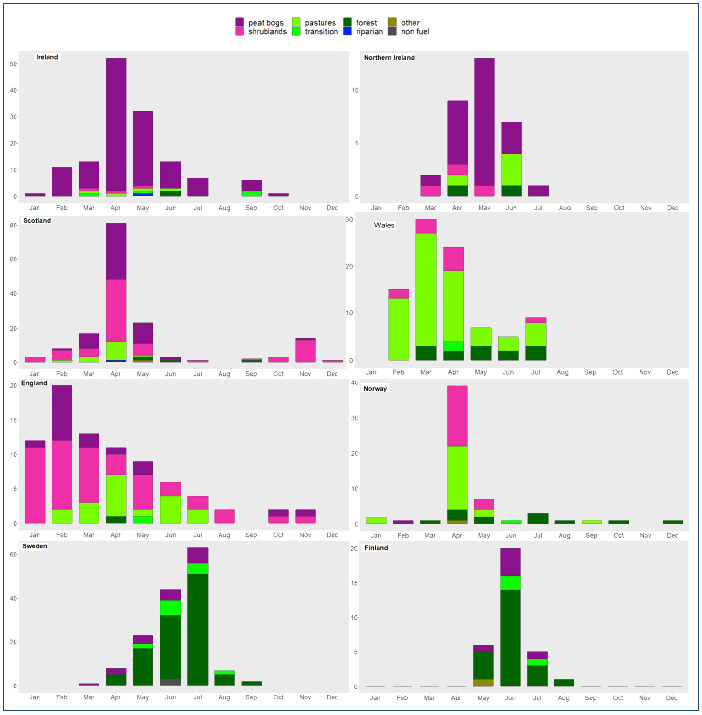
Results of this analysis show common seasonality patterns of fire occurrence for the Republic of Ireland, Northern Ireland, Scotland, Wales and Norway where most fires occurred in spring months, although fires in Wales seem to start earlier in late winter. Most fires in England occurred in late winter and spring, while summer forest fires are clearly the dominant wildfire type in Sweden and Finland. In terms of fuel type composition, we can identify that peat bogs and heathlands are the most frequent fuel groups for the Republic of Ireland, Northern Ireland, Scotland, England and Norway, fires on grasslands and/or shrublands are the most frequent in Wales and also in Norway, while forest fires are the most frequent in Sweden and Finland. Fires in the Republic of Ireland and the UK seem to share similar wildfire occurrence patterns due to similarities in fuel type compositions and the prevalent oceanic climatic conditions. This also seems to be the case for fires close to the west coast of Norway, where the climate is oceanic and heathlands are the predominant vegetation (Fernandez-Anez et al, 2021). On the other hand, the dominance of forest fires in Sweden and Finland can be attributed to the high forest coverage in both countries combined with the presence of more temperate climatic conditions that lead to hotter summers, at least in central and southern areas of Sweden where the biggest summer forest fires occurred (Figure 7.1).
Contact
Email: alison.seton@gov.scot