Scottish Fire and Rescue Service (SFRS) - wildfire: incident reporting system - data analyses
This report examines Incident Reporting System (IRS) data on wildland fire incidents and uses these to improve the understanding of how upland wildfires start, investigate if wildfire occurrence differs between geographical areas; and describe how wildfires exhibit seasonal and temporal trends.
3 Methodology
3.1 Overview
The main objective of the methodological approach is to investigate how and to what extent can the Scottish Fire and Rescue Service (SFRS) Incident Reporting System (IRS) data be used to detect wildfires, which for the purpose of this project are defined as wildland fires affecting seminatural habitats in Scotland.
The analysis is based on harmonising and filtering the SFRS IRS data to identify wildfires and on devising and using methods for assessing the relation (spatial) between the location of SFRS IRS data and a) location of ignition and b) respective fuel types responsible for ignition and c) other biophysical and socioeconomical information. The methodology aims to establish these relationships with confidence to enable identifying temporal and seasonal patterns of wildfire occurrence and patterns related to fuel types, along with the investigation of patterns related to extent of burnt areas, motives for ignition and accessibility.
The methodology uses a combination of statistical and geospatial analyses of recorded information within the SFRS IRIS dataset and information derived from satellite imagery and from various spatial datasets related to wildfires available from different sources. The steps involved in the methodology are shown in Figure 3.1 and are briefly described in paragraphs 3.2 to 3.7 below. A more detailed description of the methodology is given in the Sections 4 to 9.
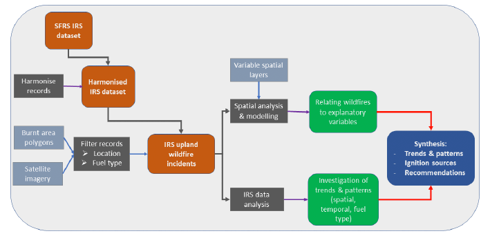
3.2 Developing the IRS wildfires dataset
The first part of the analysis consists of the harmonisation of land use information within the IRS fire incidents dataset and the filtering procedure for identifying and selecting wildfires.
3.2.1 Harmonisation of land use information
Harmonising land use information forms the basis for developing the filtering process as land use and fuel type are the main information used to identify fires affecting seminatural vegetation. The analysis is based on devising a classification scheme at aggregated broad habitat and land use levels that is common to the IRS recorded information and to a set of available spatial layers of habitat, land use and fuel type of different scales and resolutions.
3.2.2 Identifying and selecting wildfire incidents
The purpose of the analysis is to identify IRS fires that affect seminatural habitats and to exclude urban fires (e.g., bonfires, vehicles, rubbish or unspecified) from further analysis. The process for identifying wildfires is based on the combined investigation of their recorded location, in relation to boundaries of settlements in Scotland, and vegetation/fuel type information from the relevant IRS fields and other spatial land use layers. Filtering of IRS records is based on a set of rules using the geographical and land use information and the final selection of wildfires is completed after extensive visual inspection of land use and vegetation type from satellite imagery at the locations of the filtered IRS fire incidents.
3.3 Investigation of patterns in the IRS wildfires dataset
This part of the analysis uses the information recorded in the filtered IRS wildfire dataset to identify temporal and seasonality patterns, vegetation/fuel type patterns of wildfire occurrence in Scotland and patterns related to burnt area extents, motives, and accessibility. Results are presented at a National and Local Authority level in the form of appropriate tables, figures, and maps, and are used to improve our understanding as to why these patterns emerge in certain areas, fuel types and time periods.
3.4 Comparing IRS wildfire properties using datasets of burnt areas
This part of the analysis uses available spatial datasets of burnt areas that have been produced from satellite imagery analysis, along with new burnt areas delineated in the context of this project, in order to provide an assessment of the a) The proximity of the location recorded within the IRS to the actual burnt area; b) Similarity of recorded land use/fuel type in the IRS with land use/fuel type present within the burnt area polygons; and c) Similarity between recorded burnt areas within the IRS and actual burnt area calculated from the delineated polygons. To enable this comparison, we used the date of IRS wildfires incidents and their location to identify those wildfires that corresponded to the available polygons of burnt areas.
3.5 Comparing wildfire patterns in Northern Europe
This part of the analysis aims to investigate and compare patterns of seasonality and fuel type in wildfires occurring in selected Northern European countries with similar bioclimatic conditions and land management practices to Scotland, using burnt area and fuel type information available at a European level. Countries included in this analysis were the Republic of Ireland, Northern Ireland, Scotland, Wales, England, Norway, Sweden and Finland.
3.6 Relating IRS wildfires to explanatory variables of fire occurrence
This part of the analysis aims to improve our understanding of causative factors of wildfire ignition by relating the spatial distribution of recorded IRS wildfires with information from readily available spatial layers of explanatory variables of fire occurrence (e.g., bioclimatic, topographical, land use, accessibility and socioeconomical factors). These spatial relationships between IRS wildfires and different variables are used to demonstrate how to build models of ignition risk in a test area (Highland Local Authority) that can be used for wildfire management and preparedness.
3.7 Synthesis and Recommendations
Results from the analyses conducted are used to summarise the identified patterns of wildfire occurrence in Scotland and infer assumptions about ignition sources. We also assess the usefulness of the SFRS IRS dataset for detecting wildfires affecting seminatural habitats and provide recommendations for improving the IRS dataset for this purpose.
Contact
Email: alison.seton@gov.scot