Scottish Fire and Rescue Service (SFRS) - wildfire: incident reporting system - data analyses
This report examines Incident Reporting System (IRS) data on wildland fire incidents and uses these to improve the understanding of how upland wildfires start, investigate if wildfire occurrence differs between geographical areas; and describe how wildfires exhibit seasonal and temporal trends.
4 Developing the SFRS IRS wildfires dataset
4.1 Harmonisation of land use information
Initial investigation of the IRS dataset showed that the records are complete and that there is a consistent set of categories used to describe the likely fuel types (as given in the Levels 2 and 3 Property Types). Initial investigation and findings from previous studies (Davies and Legg, 2016) have shown that, for a substantial number of the IRS records that are assumed to relate to wildfires, the location recorded is where the fire was reported from or where fire-fighting resources were marshalled rather than the core or ignition point of the fire itself. This is likely to be true for most remote wildfires with difficult access. Therefore, it was necessary to check the recorded IRS fuel type information against other available land use and fuel type information to account for the known issues related to the positional accuracy of fire incident locations. For this reason, we used the following available spatial datasets:
- EUNIS habitat classification map (20m raster) produced by Space Intelligence in partnership with NatureScot (https://www.space-intelligence.com/scotland-landcover).
- Land Cover Scotland 1988 map (LCS88) map at 1:25,000 scale (MLURI, 1993).
- Land Cover Map 2015 (LCM15, 25m raster) produced by the Centre of Ecology and Hydrology (CEH, 2017).
- European Fuel Types Map (250m raster) produced by the European Forest Fire Information System (EFFIS, 2017).
The EUNIS, LCM15 and EFFIS Fuel Type (FT) maps were available in Geotiff format and were produced using different satellite imagery products, while LCS88 was available in ESRI shapefile (polygon) format and produced with a combination of on-ground surveying and interpretation of aerial orthophoto maps. This set of maps provide a comprehensive overview of vegetation and land use patterns in Scotland at different scales, but they also use slightly different land use categories. Therefore, it was necessary to devise a common classification scheme that could cover all IRS Level 3 Property Types and harmonise them with the EUNIS, LCS88, LCM15 and EFFIS FT maps. We developed aggregated categories using our expert knowledge of Scottish vegetation types at a) Broad Habitat (BH) level and b) Land Use (LUSE) level, with BHs being finer in their classification than LUSEs. The aggregated LUSE classes were mainly used for the filtering of IRS fire incidents to identify wildfires, while BHs were mainly used to investigate patterns related to fuel type composition.
The results of this process for each of the five datasets are given in Tables 4.1 to 4.5. As expected, there was not always clear correspondence between all land use classes and vegetation types considered or there were ambiguities about the type of vegetation described in a certain IRS Property Type. Therefore, in many cases we had to resort to our judgement coupled with extensive visual inspection using the coordinates of IRS fire incident locations and Google satellite imagery loaded within the QGIS Geographical Information System (QGIS.org, 2021). For example, we used the land use datasets and visual inspection of satellite imagery to decide whether to assign the "Scrub land" category to a "Grasslands" or a "Shrubland" BH, because we were unsure as to what type of vegetation the "Scrub land" category refers to, since scrub vegetation could include a mixture of both grasses and shrubs. Similarly, visual inspection at the locations of fire incidents belonging to the quite extensive category of "Loose Refuse" revealed that these fires could potentially occur in seminatural, cultivated or urban areas. Therefore, we took the decision to give this category an initial LUSE class of BOTH (i.e., both cultivated and seminatural) and devise different filtering rules at the next stage depending on whether these fire incidents were inside or outside built-up areas. The same applied for the "Grassland, pasture, grazing etc" category which was given a BOTH LUSE class since it includes both managed and seminatural grasslands.
Overall, the harmonisation process highlighted two main issues in relation to identifying wildfires:
- There is no IRS Level 3 Property Type specific to Bogs and/or peatlands, which are mapped as a separate class in the EUNIS, LCS88, LCM15 and EFFIS FT datasets.
- There is no clear distinction in the IRS Level 3 Property Type between seminatural grasslands and grazed pastures, while the EUNIS, LCS88 and LCM15 maps provide the distinction between the different types of seminatural and improved grassland.
| Property Type Level 3 | BH | LUSE |
|---|---|---|
| Airfield/runway | Built-up | URBAN |
| Animal harm outdoors | None | NONE |
| Beach | Other | OTHER |
| Canal/riverbank vegetation | Grasslands | BOTH |
| Cemetery | Built-up | URBAN |
| Cycle path/public footpath/bridleway | Linear features | URBAN |
| Golf Course (excluding buildings) | Built-up | URBAN |
| Grassland, pasture, grazing etc | Grasslands | BOTH |
| Heathland or moorland | Shrubland | SEMI |
| Hedge | Grasslands | SEMI |
| Highway/road surface/pavement | Linear features | URBAN |
| Human harm outdoors | None | NONE |
| Lake/pond/reservoir | Freshwater | WATER |
| Loose refuse (incl. in garden) | Refuse | BOTH |
| Nurseries, market garden | Grasslands | CULT |
| Other outdoor location | Other | OTHER |
| Park | Built-up | URBAN |
| Playground (not equipment) or Recreational area | Built-up | URBAN |
| Private/Domestic garden/allotment (vegetation not equipment/building) | Grasslands | URBAN |
| Railway | Linear features | NONE |
| Railway trackside vegetation | Linear features | BOTH |
| River/canal | Freshwater | WATER |
| Roadside vegetation | Linear features | BOTH |
| Scrub land | Grasslands | SEMI |
| Sea | Freshwater | WATER |
| Stacked/baled crop (incl manure heap) | Arable | CULT |
| Standing crop | Arable | CULT |
| Straw/stubble burning | Arable | CULT |
| Tree scrub (includes single trees not in garden) | Broadleaves | SEMI |
| Wasteland | Refuse | BOTH |
| Woodland/forest - broadleaf/hardwood | Broadleaves | SEMI |
| Woodland/forest - conifers/softwood | Conifers | SEMI |
| EUNIS habitat classes | BH | LUSE |
|---|---|---|
| C Surface standing and running waters | Freshwater | WATER |
| D1 Raised and blanket bogs | Bogs & peatlands | SEMI |
| D2 Valley mires, poor fens and transition mires | Bogs & peatlands | SEMI |
| D4 Base-rich fens and calcareous spring mires | Bogs & peatlands | SEMI |
| E1 Dry grasslands | Grasslands | SEMI |
| E2 Mesic grassland | Grasslands | BOTH |
| E3 Seasonally wet and wet grasslands | Grasslands | SEMI |
| E4 Alpine and subalpine grasslands | Montane | SEMI |
| E5 Woodland fringes and clearings and tall forb stands | Linear features | SEMI |
| F2 Arctic, alpine and subalpine scrub | Montane | SEMI |
| F3 Temperate and mediterranean-montane scrub | Montane | SEMI |
| F4 Temperate shrub heathland | Shrubland | SEMI |
| F9 Riverine and fen scrubs | Riparian | SEMI |
| G1 Broadleaved deciduous woodland | Broadleaves | SEMI |
| G3 Coniferous woodland | Conifers | SEMI |
| G4 Mixed deciduous and coniferous woodland | Mixed woodland | SEMI |
| G5 Lines of trees, small anthropogenic woodlands, early-stage woodland and coppice | Linear features | SEMI |
| H2 Screes | Screes | SEMI |
| H3 Cliffs and rock pavements | Cliffs | SEMI |
| I1 Arable land and market gardens | Arable | CULT |
| J Built-up | Built-up | URBAN |
| O Bare field | Bare | CULT |
| LCS88 | BH | LUSE |
|---|---|---|
| Arable | Arable | CULT |
| Blanket bog & peatlands | Bogs & peatlands | SEMI |
| Bracken | Grasslands | SEMI |
| Broadleaved woodland | Broadleaves | SEMI |
| Cliffs | Cliffs | SEMI |
| Coarse & smooth grassland | Grasslands | SEMI |
| Coniferous plantation | Conifers | SEMI |
| Factories & urban | Built-up | URBAN |
| Heather moor | Shrubland | SEMI |
| Improved grassland | Grasslands | CULT |
| Low scrub | Grasslands | SEMI |
| Mixed woodland | Mixed woodland | SEMI |
| Montane vegetation | Montane | SEMI |
| Open canopy young plantation | Conifers | SEMI |
| Recreational land | Built-up | URBAN |
| Ripping | Conifers | SEMI |
| Water | Freshwater | WATER |
| Wetland | Bogs & peatlands | SEMI |
| LCM15 classes | BH | LUSE |
|---|---|---|
| Broadleaved Woodland | Broadleaves | SEMI |
| Coniferous Woodland | Conifers | SEMI |
| Arable and Horticulture | Arable | CULT |
| Improved Grassland | Grasslands | CULT |
| Neutral Grassland | Grasslands | SEMI |
| Calcareous Grassland | Grasslands | SEMI |
| Acid Grassland | Grasslands | SEMI |
| Fen, Marsh and Swamp | Grasslands | SEMI |
| Heather | Shrubland | SEMI |
| Heather grassland | Shrubland | SEMI |
| Bog | Bogs & peatlands | SEMI |
| Inland Rock | Screes | SEMI |
| Saltwater | Other | OTHER |
| Freshwater | Freshwater | WATER |
| Supra-littoral Rock | Other | OTHER |
| Supra-littoral Sediment | Other | OTHER |
| Littoral Rock | Other | OTHER |
| Littoral Sediment | Other | OTHER |
| Saltmarsh | Other | OTHER |
| Urban/Suburban | Built-up | URBAN |
| EFFIS FT group | BH4 | LUSE4 |
|---|---|---|
| Agroforestry | Grasslands | SEMI |
| Broadleaved forests | Broadleaves | SEMI |
| Conifer forests | Conifers | SEMI |
| Mixed forests | Mixed woodland | SEMI |
| No Data | No data | NONE |
| Not fuel | Arable | CULT |
| Not fuel | Built-up | URBAN |
| Not wildland fuels | Arable | CULT |
| Pastures | Grasslands | SEMI |
| Peat bogs | Bogs & peatlands | SEMI |
| Riparian and aquatic vegetation | Riparian | SEMI |
| Shrublands | Shrubland | SEMI |
| Transition shrubland-forest | Shrubland | SEMI |
4.2 Identifying wildfires affecting seminatural habitats
4.2.1 Devising the filtering process
The filtering process for identifying wildfires in the IRS dataset is based on a) their location in relation to whether they fall inside or outside built-up areas; and b) their fuel type information. Built-up areas were defined using the National Records of Scotland (NRS) Settlements 2016 map (in ESRI shapefile format downloaded from https://spatialdata.gov.scot), which gives built-up areas with a population of 500 people or more. Fuel type was defined using aggregated Broad Habitat (BH) and Land Use (LUSE) classes classified from the recorded IRS Level 3 Property Types and from the EUNIS, LCS88, LCM15 and EFFIS FT habitat and land use maps. The IRS fires incidents were imported into QGIS using their coordinate information, along with the NRS Settlements and different habitat type and land use maps (all in ESRI shapefile format). We applied a 100m buffer to the settlement boundaries as suggested previously by Davies and Legg (2016) to account for uncertainties in locational accuracy.
We intersected the IRS fire incidents with the NRS settlement buffered boundaries and habitat type and land use maps and extracted their values at the IRS incident locations. We coded IRS fire incidents as "inside or outside of settlements" and harmonised the BH and LUSE class information for each IRS fire incident using the classification scheme of Tables 4.2 to 4.5. The most frequent LUSE class was calculated for each IRS fire incident using the EUNIS, LCS88 and LCM15 map for the fire incidents located within settlement boundaries, plus the EFFIS FT map for those fire incidents outside settlement boundaries. We didn't use the EFFIS FT map within settlements because its resolution was too coarse and hence not appropriate for this purpose. The classification and harmonisation processes were implemented in the R statistical software (R Core Team, 2020).
As expected, almost all 63,380 fire incidents (92%) belonging to the "Other outdoors (including land)" category, which were more likely to be urban fires, were located inside settlement boundaries. At the same time, the majority of the 69,449 fire incidents (75%) under the "Grassland, woodland and crops", which were likely to include almost all existing wildfires, were also located within settlement boundaries. This was expected since the NRS dataset does not only include large urban areas but also small settlements in rural areas and around small settlements where wildfires are more likely to occur.
We used the IRS fire incidents with the extracted settlement and land use type information to devise a set of rules to filter the dataset and identify those fire incidents more likely to relate to wildfires affecting seminatural habitats. We need to stress that devising these rules was an iterative process based on extensive trial and testing using visual inspection of satellite imagery provided from Google and loaded within QGIS. The filtering process was semi-automated and was implemented using scripts written and executed within R coupled with visual inspection in QGIS. It is highly likely that the filtering process did not necessarily identify all fire incidents likely to be wildfires, but we are highly confident that those fires selected are actual wildfires.
The rules and criteria used for the filtering process are given in Table 4.6. Rules were devised for each of the individual Level 3 Property Types based on their LUSE classification as given in Table 4.1. As expected, there were differences between BHs and LUSE classified using the IRS Level 3 Property Types (Table 4.1) and BHs and LUSE classified using the land use datasets (Tables 4.2 to 4.5); these were attributed to issues related to different classification schemes and the difficulty to harmonise all datasets, to different spatial accuracies of the layers used that led to spatial inconsistencies between datasets and inherent ambiguities regarding how fuel type is recorded within the IRS. For example, of the 7,417 IRS fire incidents under the "Heathland and moorland" Property Type, which were assigned a "Shrubland" BH (Table 4.1), only 302 fire incidents also had a "Shrubland" BH based on the EUNIS Habitat Types map, but another 996 and 196 fire incidents had a "Bogs & peatlands" and "Montane" BH, respectively, while a further 1,632 fire incidents were classified as "Grasslands" and 1,329 as "Built-up".
| IRS Property Type Level 3 LUSE | Inside settlements | Most frequent LUSE | Process |
|---|---|---|---|
| SEMI (n=39,208) | Yes | SEMI | Check for seminatural BHs & visual inspection |
| Other than SEMI | Check for seminatural BHs & visual inspection | ||
| No | SEMI | Visual inspection | |
| CULT | Check for seminatural BHs & visual inspection | ||
| BOTH | Check for seminatural BHs & visual inspection | ||
| Rest LUSEs | Check for seminatural BHs & visual inspection | ||
| CULT (n=2,202) | Yes | SEMI | Check for seminatural BHs & visual inspection |
| Other than SEMI | Remove fire incident | ||
| No | SEMI | Visual inspection | |
| SEMI at least once | Check for seminatural BHs & visual inspection | ||
| Other than SEMI | Remove fire incident | ||
| BOTH (n=69,200) | Yes | SEMI | Check for seminatural BHs & visual inspection |
| Other than SEMI | Remove fire incident | ||
| No | SEMI | Visual inspection | |
| SEMI at least once | Check for seminatural BHs & visual inspection | ||
| Other than SEMI | Remove fire incident | ||
| URBAN (n=12,217) | Yes | SEMI | Check for seminatural BHs & visual inspection |
| Other than SEMI | Remove fire incident | ||
| No | SEMI or SEMI at least one | Check for seminatural BHs & visual inspection | |
| Other than SEMI | Remove fire incident | ||
| OTHER (n=9,678) | Yes | SEMI | Check for seminatural BHs & visual inspection |
| Other than SEMI | Remove fire incident | ||
| No | SEMI or SEMI at least one | Check for seminatural BHs & visual inspection | |
| Other than SEMI | Remove fire incident | ||
| WATER (n=170) | Yes | SEMI | Check for seminatural BHs & visual inspection |
| Other than SEMI | Remove fire incident | ||
| No | SEMI or SEMI at least one | Visual inspection | |
| Other than SEMI | Remove fire incident | ||
| NONE (n=154) | Yes | SEMI | Check for seminatural BHs & visual inspection |
| Other than SEMI | Remove fire incident | ||
| No | SEMI or SEMI at least one | Visual inspection | |
| Other than SEMI | Remove fire incident |
Below, we provide a brief description of the rules and process shown in Table 4.6 that was used to filter the IRS dataset for identifying wildfires:
- Fire incidents with a seminatural (SEMI) IRS LUSE falling within settlement boundaries were selected as wildfires when their BHs (mainly from the EUNIS dataset that is the most recent one and has the better spatial resolution) were of seminatural vegetation (mainly bogs and peatlands, shrublands and montane vegetation) and after verifying via visual inspection. In many cases SEMI was referring to trees or woodlands in recreational areas and in urban areas (e.g., parks); these fire incidents were excluded from the dataset. On the other hand, this approach ensured that fires in seminatural areas within urban centre boundaries (e.g., known fire incidents in Arthur's Seat in Edinburgh) were identified and kept in the dataset.
- All fire incidents located outside settlements with a SEMI IRS LUSE class were either selected based on visual inspection (if most frequent LUSE was also SEMI) or based on the combination of visual inspection and checking for the presence of seminatural BHs.
- Fire incidents with a cultivated (CULT) IRS LUSE class but with SEMI as the most frequent LUSE class or with at least one SEMI LUSE class present were selected based on the combination of visual inspection and checking for the presence of seminatural BHs, regardless of whether they were inside or outside settlement boundaries. This was done to ensure that fire incidents in cultivated land in the vicinity of seminatural vegetation were identified, since they were likely to affect seminatural habitats. A similar approach was also used for fire incidents with a BOTH (both seminatural and cultivated) IRS LUSE class.
- Fire incidents with an URBAN (i.e., likely to be located within built-up areas) IRS LUSE class but with a SEMI most frequent LUSE class (for fire incidents within settlement boundaries) or at least one SEMI LUSE (for fire incidents outside settlement boundaries) were checked for the presence of seminatural BHs and/or visual inspected. All remaining URBAN LUSE IRS fire incidents, with LUSE other than SEMI, were removed from further analysis. The same rules were also applied to the fire incidents of the remaining IRS LUSE classes (OTHER, WATER and NONE).
4.2.2 Filtered dataset of IRS wildfires
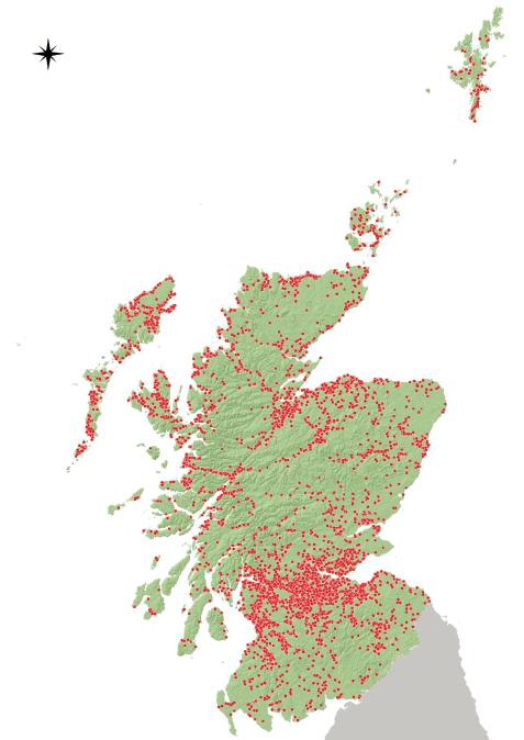
The result of the filtering process resulted in the selection of 9,725 IRS fire incidents as the most likely to be wildfires. Around 85% of identified wildfires (8,271 fire incidents) were located outside the buffered settlement boundaries, with the remaining 1,454 fire incidents falling within the settlement boundaries (Table 4.7). The spatial distribution of the identified IRS wildfires is shown in Figure 4.1.
| Property Type Level 3 | Count | Proportion (%) | ||
|---|---|---|---|---|
| Outside | Within | Outside | Within | |
| Beach | 26 | 3 | 90 | 10 |
| Canal/riverbank vegetation | 106 | 0 | 100 | 0 |
| Cemetery | 3 | 0 | 100 | 0 |
| Cycle path/public footpath/bridleway | 54 | 0 | 100 | 0 |
| Golf Course (excluding buildings) | 4 | 0 | 100 | 0 |
| Grassland, pasture, grazing etc | 1301 | 578 | 69 | 31 |
| Heathland or moorland | 2431 | 259 | 90 | 10 |
| Hedge | 29 | 2 | 94 | 6 |
| Highway/road surface/pavement | 18 | 0 | 100 | 0 |
| Human harm outdoors | 1 | 0 | 100 | 0 |
| Lake/pond/reservoir | 7 | 0 | 100 | 0 |
| Loose refuse (incl in garden) | 652 | 11 | 98 | 2 |
| Nurseries, market garden | 0 | 1 | 0 | 100 |
| Other outdoor location | 382 | 3 | 99 | 1 |
| Park | 56 | 2 | 97 | 3 |
| Playground (not equipment) or Recreational area | 2 | 3 | 40 | 60 |
| Private/Domestic garden/allotment (vegetation not equipment/building) | 24 | 4 | 86 | 14 |
| Railway | 13 | 0 | 100 | 0 |
| Railway trackside vegetation | 52 | 0 | 100 | 0 |
| River/canal | 7 | 0 | 100 | 0 |
| Roadside vegetation | 284 | 4 | 99 | 1 |
| Scrub land | 988 | 529 | 65 | 35 |
| Stacked/baled crop (incl manure heap) | 48 | 0 | 100 | 0 |
| Standing crop | 2 | 0 | 100 | 0 |
| Straw/stubble burning | 52 | 1 | 98 | 2 |
| Tree scrub (includes single trees not in garden) | 902 | 45 | 95 | 5 |
| Wasteland | 124 | 0 | 100 | 0 |
| Woodland/forest - broadleaf/hardwood | 219 | 0 | 100 | 0 |
| Woodland/forest - conifers/softwood | 484 | 9 | 98 | 2 |
The filtering process revealed significant disparities between fuel type information recorded in the IRS and respective information extracted from the different land use maps at the locations of the fire incidents. For this reason, we built confusion matrices and checked the agreement at a Broad Habitat (BH) level between IRS recorded fuel type information and extracted information from the land use maps. The results of this analysis for individual BHs and for overall agreement are given in Table 4.8. As expected, there was no agreement for the Bogs & peatlands category as this is not included in the IRS property types. Agreement at BH level and overall for all BHs was lowest for the EFFIS FT, probably due to the coarser resolution of this dataset. Agreement for woodlands (broadleaves and conifers) were similar but low for the EUNIS, LCS88 and LCM15 maps. Agreement was higher for grasslands, almost 60% for the EUNIS map and 54% for the LCS88 map. This was because most fire incidents in the "Scrub land" IRS Property Type were located in grassland areas in the EUNIS and LCS88 maps. The LCS88 map gave the closest match with the IRS records for Shrubland (75%), followed by the EUNIS (69%) and LCM15 (65%) maps, while LCS88 gave the greater overall accuracy. Based on these results, we decided to use fuel type information in our investigation of patterns in the IRS wildfires dataset (Section 5) from both the IRS Property Types and from information extracted from the LCS88 map. Additionally, using the LCS88 maps enabled us to include the Bogs and peatlands BH in the analysis and to distinguish between seminatural and managed grasslands, which is quite useful for detecting patterns of wildfire occurrence in seminatural habitats in Scotland.
| Property Type Level 3 | EUNIS | LCS88 | LCM15 | EFFIS FT |
|---|---|---|---|---|
| Arable | 0 | 4 | 2 | 2 |
| Bare | 0 | - | - | - |
| Bogs & peatlands | 0 | 0 | 0 | 0 |
| Broadleaves | 27 | 27 | 25 | 26 |
| Built-up | 0 | 0 | 2 | 4 |
| Cliffs | 0 | - | - | - |
| Conifers | 24 | 22 | 20 | 12 |
| Freshwater | 2 | 0 | 5 | |
| Grasslands | 59 | 54 | 47 | 44 |
| Linear features | 6 | - | - | - |
| Mixed woodland | 0 | 0 | 0 | |
| Montane | 0 | 0 | - | - |
| Riparian | 0 | - | - | 0 |
| Other | - | - | 23 | - |
| Screes | 0 | - | 0 | - |
| Shrubland | 69 | 75 | 65 | 42 |
| Overall agreement | 33 | 36 | 32 | 25 |
Contact
Email: alison.seton@gov.scot