Local development planning guidance
Guidance setting out the Scottish Ministers' expectations for implementing the system of local development plans - so that they deliver new-style, place-based, people-centred and delivery-focussed plans. It brings together requirements from the Act and Regulations and advice in relation to National Planning Framework 4.
Step by step guide
42. This part of the guidance outlines the process for preparing LDPs, and offers advice on relevant evidence to include in the Evidence Report, and on how planning authorities may take NPF4 into account when preparing their Proposed Plans. This should be in line with the aims that plans should be: place-based, people-centred and delivery-focused. It provides a route through the process, with each stage described under the following headings:
Purpose – the contribution of the stage to a plan being deliverable, place-based and people-focused.
Legislative Requirements – the statutory requirements of the Town and Country Planning (Scotland) Act 1997 as amended, and the Regulations.
Implementation – further guidance on the Scottish Ministers' expectations for how legislative requirements should be put into practice.
Responsibilities – the key stakeholders involved*, including but not limited to statutory requirements for engagement. Further detail on effective community engagement will be set out in separate guidance.
Bigger Picture – outlining related processes and activities*.
*Suggestions in the guidance should not be seen as exhaustive – local circumstances may inform other stakeholders or activities being involved. The guidance is not binding, and should be taken into account in a proportionate way.
Overview of the LDP process and legislative requirements
Legislative requirements
43. Planning authorities are required by law to prepare an LDP for all parts of their district (section 16(1)). LDPs must be prepared at intervals of no more than 10 years or when required by the Scottish Ministers (section 16(1)(a)). Planning authorities may prepare more than one LDP for the same area, as long as the purposes of the plans are different (section 16(3)). The boundaries for such different plans need not be the same (section 16(4)). Two or more planning authorities may prepare a joint LDP applying to part or all of their areas (section 16(5)).
44. Planning authorities must keep the plan under review and in doing so, monitor changes in a range of characteristics set out in legislation (section 16(1)(b), section 16(8)(a)). These characteristics are set out at Annex E (section 15(5)). They must also monitor the impact of policies and proposals contained in LDPs (section 16(8)(b)).
45. In line with section 16(2)(a) of the Act other spatial plans that planning authorities are to take into account in the preparation of an LDP are:
- the NPF;
- any LOIP for the area; and
- any registered LPPs for the area.
46. In line with regulation 9, in preparing an LDP the planning authority are to have regard to:
- any RSS prepared for the LDP area or an area adjoining the LDP area;
- any LDP prepared for a different purpose for the LDP area;
- any LDP prepared for an area adjoining the LDP area; and
- where the LDP area adjoins land in England, any document which forms part of the development plan for the area in which that land is situated.
47. Also in line with regulation 9, in preparing an LDP planning authorities should have regard to:
- the national marine plan; and
- any regional marine plan
insofar as relating to the LDP area.
48. Further details of information and considerations to be had regard to by planning authorities when preparing LDPs is set out later in this guidance. In line with section 16(2)(c) in preparing an LDP the planning authority may have regard to such other information and considerations as appear to them to be relevant.
Implementation
49. Local development planning has three key stages, as shown in Figure 4 and expanded upon in more detail in Figure 5.
- Evidence Gathering
- Plan Preparation
- Delivery of the plan
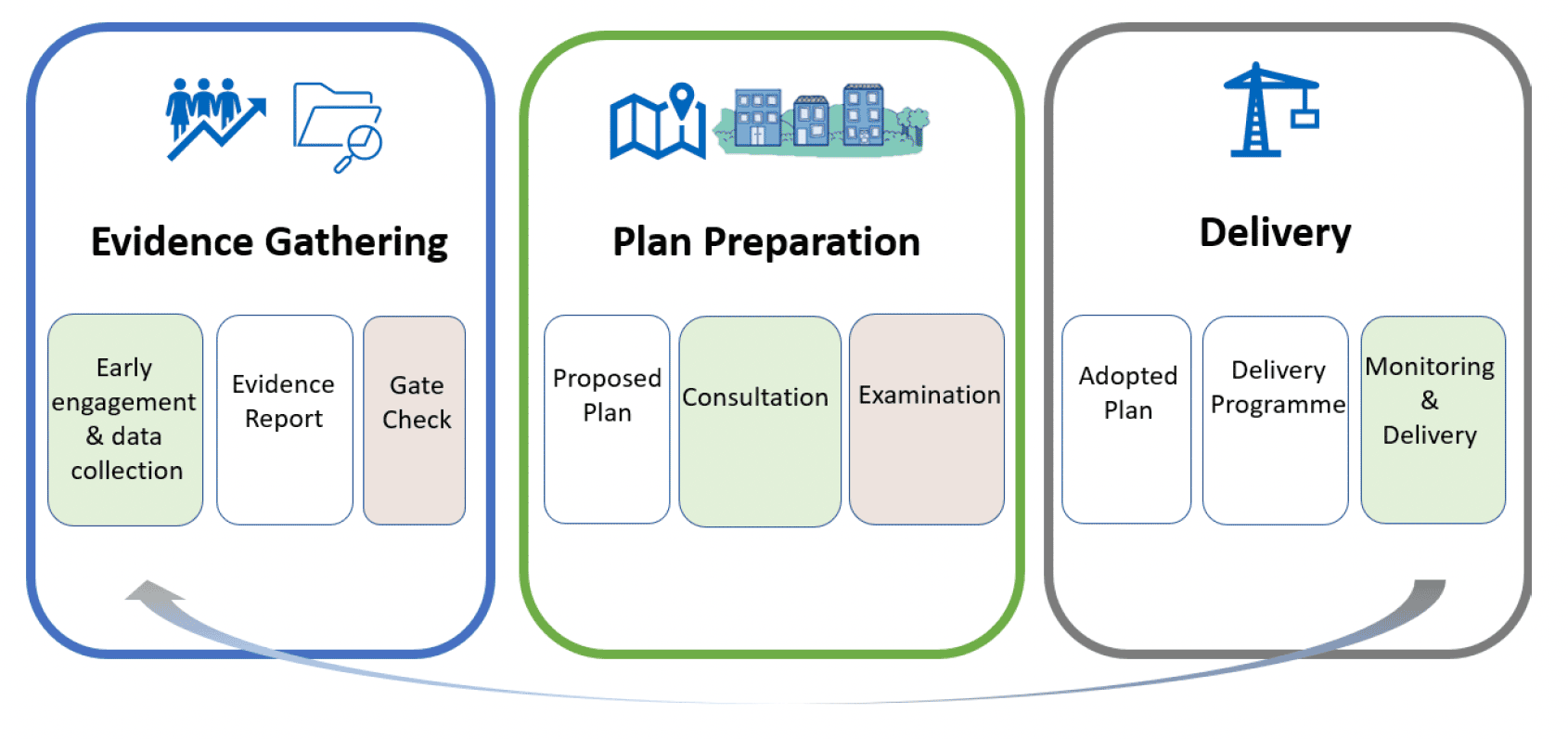
Graphic text below:
Evidence Gathering
- Early engagement & data collection
- Evidence Report
- Gate Check
50. Plan preparation is one part of development planning activity. Evidence gathering and implementation and delivery of the policies and proposals also contribute to achieving the intended outcomes. Whilst the adoption of a plan is a significant milestone, it is not the end point. Monitoring will form a feedback loop, providing data that will be needed for the evidence gathering for amendment of the plan, or the next LDP.
51. The 10 year period for review of an LDP includes ensuring a robust evidence base and delivery of the plan. The LDP should not take 10 years to prepare. It is expected that plan preparation should take around 3-4 years, allowing more time for a focus on the delivery of the plan in the remaining years and subsequent monitoring and evidence gathering to inform the next plan.
52. Provisions in the Act for amendment of LDPs are not yet in force, but regulations to support their implementation will be prepared in due course.
53. Local guidance can be prepared on key matters to support the LDP. It would not have the status of being part of the development plan, but where relevant to a decision would be a material consideration to be afforded such weight as determined by the decision maker.
54. There are also additional statutory duties to prepare a Development Plan Scheme (DPS) and a Delivery Programme, and to invite communities to prepare LPPs. These tools can support project planning, stakeholder engagement and community involvement in the plan. The step by step guide part of this guidance provides further information on each of these duties and stages.
Responsibilities
55. It is the responsibility of the planning authority to prepare the LDP, but in doing so they should collaborate with stakeholders. A wide range of stakeholders should be involved, including from within the planning authority and wider sectors and groups. This is likely to include:
- the planning authority's wider services including for the natural environment and climate change, heritage and archaeology, parks and greenspace, community planning, education, economic development, housing, transport, marine planning, town centres and regeneration;
- national and regional agencies;
- local communities, community councils and relevant communities of interest;
- infrastructure and service providers, including public health teams and healthcare providers, public transport providers, telecommunications and electricity network companies;
- landowners and land managers;
- businesses and investors, and developers of all sectors;
- home builders, both public and private sector;
- representatives from the creative sector;
- voluntary organisations and the third sector; and
- relevant amenity bodies.
56. Regulation 25 sets out those agencies referred to as 'key agencies', these are:
- Historic Environment Scotland;
- NatureScot;
- Scottish Environmental Protection Agency;
- Scottish Water;
- Scottish Enterprise (only in its area of jurisdiction);
- Highlands and Islands Enterprise (only in its area of jurisdiction);
- South of Scotland Enterprise (only in its area of jurisdiction);
- Regional Transport Partnerships (only in relevant areas of jurisdiction);
- Crofting Commission (only in crofting counties and areas designated under section 3A(1)(b) of the Crofters (Scotland) Act 1993 to constitute the land as a croft); and
- Health Boards.
57. Whilst forming parts of the Scottish Government, the following should have the same level of involvement in the development planning process:
- Transport Scotland;
- Scottish Forestry; and
- Marine Scotland.
58. Further organisations which participate in the Key Agencies Group, such as Architecture and Design Scotland and SportScotland, are also likely to provide support and input.
59. As a matter of good practice, the planning authority is expected to involve a range of people at all stages in the preparation of the LDP. The authority must engage with the public at large and seek the views of particular organisations and societal groups, including key agencies, children and young people, disabled persons, Gypsies and Travellers and community councils.
60. Further detail on the requirements to engage with particular groups is outlined below. Associated guidance on effective community engagement provides further information.
Figure 5: LDP Process – Key stages and links to assessments
Evidence Gathering
Key Stage: Early Preparation
Local Development Plan:
DPS
Prepared at least annually (or when directed by the Scottish Ministers), includes Participation Statement.
Adopted by planning authority.
Invitation to local communities to prepare LPPs.
Early thinking regarding Delivery Programme and integrating it with plan preparation.
Strategic Environmental Assessment (SEA):
Programme for work on SEA set out in DPS.
Other Appraisal / Assessment:
DPS sets out programme for work on impact assessments including:
Public Sector Equality Duty Assessment;
Fairer Scotland Duty Assessment;
Island Communities Impact Assessment (where relevant);
Habitats Regulations Appraisal (HRA).
Key Stage: Evidence Report
Local Development Plan:
Gather and collate appropriate evidence.
Seek views of key agencies, children and young people, and the public at large in the preparation of the Evidence Report.
Prepare Evidence Report.
Approval of Evidence Report by full Council.
Submission to the Scottish Ministers.
Strategic Environmental Assessment (SEA):
Scoping workshop.
Collect Environmental Baseline.
Prepare Scoping Report.
Submit Scoping Report to Consultation Authorities.
Other Appraisal / Assessment:
DPS sets out programme for work on impact assessments including:
Public Sector Equality Duty Assessment;
Fairer Scotland Duty Assessment;
Island Communities Impact Assessment (where relevant);
Habitats Regulations Appraisal (HRA).
Key Stage: Gate Check
Local Development Plan:
The Scottish Ministers appoint person to assess Evidence Report. Gate Check of Evidence Report.
Requests for further information and / or hearings as appropriate.
If evidence considered sufficient, appointed person informs planning authority and Scottish Ministers.
If evidence not sufficient, appointed person prepares "assessment report".
Plan Preparation
Key Stage: Work to inform Proposed Plan
Local Development Plan:
Using Evidence Report, develop a spatial strategy incorporating an infrastructure first approach and considering the spatial principles in NPF4.
Early engagement such as a call for ideas.
Site assessment.
Strategic Environmental Assessment (SEA):
Identification and assessment of reasonable alternatives.
Site assessment.
Other Appraisal / Assessment:
Undertake transport appraisal.
Key Stage: Proposed Plan (Drafting)
Local Development Plan:
Preparation of Proposed Plan, including spatial strategy.
Delivery Programme:
- Consult with key agencies, the Scottish Ministers and anyone named in the Programme during preparation
- Approval by full Council before publication.
Proposed Plan approval by full Council.
Strategic Environmental Assessment (SEA):
Assess any local policies.
Prepare Environmental Report.
Other Appraisal / Assessment:
Prepare required Assessments (as noted above).
Key Stage: Publication & Consultation
Local Development Plan:
Publish Proposed Plan, Evidence Report and Delivery Programme together.
Consultation:
- 12 weeks statutory minimum
- consult with key agencies and the Scottish Ministers
- consult with Central Scotland Green Network Partnership where appropriate
Strategic Environmental Assessment (SEA):
Consultation on Environmental Report alongside Proposed Plan.
Other Appraisal / Assessment:
Publish transport appraisal and required Assessments.
Key Stage: Modification where appropriate
Local Development Plan:
Modification of Proposed Plan where appropriate and preparation of Modification Report.
Strategic Environmental Assessment (SEA):
Revise the Environmental Report to reflect modifications and undertake further consultation, if required.
Other Appraisal / Assessment:
Revisit and update assessments as appropriate.
Key Stage: Examination
Local Development Plan:
Publish Proposed Plan and Modification Report as appropriate.
Preparation of Summary of Unresolved Issues (Schedule 3).
Where unresolved representations, appointment of person to examine plan.
Examination of Proposed Plan.
Preparation of Examination Report and Recommendations.
Modification of LDP as necessary.
Strategic Environmental Assessment (SEA):
Amend Environmental Report as required following Examination.
Submit amended Environmental Report to the Scottish Ministers.
Delivery
Key Stage: Adoption and Publication
Local Development Plan:
Adoption of LDP by planning authority.
Publish LDP.
Publish Report on Modifications or 'Recommended Modifications Statement' (where applicable).
Adopt and publish Delivery Programme within 3 months of LDP being constituted.
Strategic Environmental Assessment (SEA):
Prepare Post Adoption Statement.
Publish Post Adoption Statement.
Key Stage: Monitoring & Delivery
Local Development Plan:
LDP kept under review – monitor changes in characteristics, monitor impact of policies / proposals.
Delivery Programme:
- kept under review and updated at least every 2 years, or if the Scottish Ministers direct the authority to update it.
Housing Land Audit (HLA):
- prepared annually by each planning authority.
Strategic Environmental Assessment (SEA):
Monitoring.
Development Plan Schemes (DPS) including Participation Statements
Purpose
61. The DPS is an important communication tool. It supports deliverable and people-focussed plans by letting stakeholders know when and how they can get involved in the plan and keep them informed of progress. It is part of the wider project management of development planning. The DPS is especially important for achieving collaboration, helping stakeholders manage their responsibilities and input.
Legislative requirements
62. The relevant legislative requirements for DPSs are included within both the Act and the 2023 Regulations.
Planning authorities are to prepare LDPs for all parts of their district at intervals of no more than 10 years. - section 16(1)
A development plan scheme is a document setting out the authority's programme for preparing and reviewing their LDP. - section 20B (3)
A planning authority must prepare and publish a DPS at least annually, or when directed to do so by the Scottish Ministers. - section 20B(2)
The DPS must include
- proposed timetabling; - section 20B(4)(a)
- proposed timings for various stages of LDP plan preparation, by specifying the proposed year and quarter. The stages which require to be covered are:
- publication of the Evidence Report;
- publication of the Proposed Plan;
- submission of the Proposed Plan to the Scottish Ministers; and
- expected adoption of the LDP. - regulation 22(1) and (3)
- details of what is involved in each stage of preparation or review; and - section 20B(4)(b)
- a Participation Statement. This should outline when consultation is likely to take place, with whom and its likely form, including the steps to be taken to involve the public. - section 20B(4)(c)
If the timetable included in the DPS differs from the timetable included in the previous DPS last prepared by the planning authority, the DPS must:
(a) identify the changes to the timetable; and
(b) set out the reasons for the changes to the timetable. - regulation 22(2)
When preparing the DPS, planning authorities must seek the views of the public on what the content of the Participation Statement should be, and have regard to any views expressed. - section 20B(4A)
As soon as possible after the planning authority has adopted the DPS it must:
- send two copies to the Scottish Ministers;
- publish it, (this includes publication by electronic means / on the internet); and
- place a copy in any public library in the area to which it applies. - section 20B(5), section 20B(6)
Where a planning authority fails to comply with section 16(1)(a), i.e. fail to prepare an LDP for all parts of their district when required to do so by the Scottish Ministers or at intervals of no more than 10 years.
The Scottish Ministers may direct them to prepare a report as to the reasons for such failure and to submit that report to the Scottish Ministers. - section 16(7)
Implementation
63. The DPS is an important tool for timetabling, project management and communication. Its style, presentation and content should reflect its outward facing role.
64. It will be important for the first round of 'new style' LDPs to be prepared in a timely fashion. Every planning authority in Scotland should have a new style LDP in place within around 5 years of the Regulations coming into force i.e. by May 2028.
65. Plan preparation should take around 3-4 years – from the publication of the first DPS to adoption. This should allow more time, within the maximum 10 year cycle, to focus on the delivery of the plan, subsequent monitoring and evidence gathering to inform the next plan.
66. The required use of quarters, in the DPS for timetabling, (Quarter 1 April-June, Quarter 2: July-Sept, Quarter 3 Oct-Dec, Quarter 4 Jan-March) will ensure consistency, and support business planning and input. This will also enable stakeholders to programme their own resources for inputting, or responding to the LDP. The timings for the various stages should specify when an action is expected to be done/completed. Planning authorities should use appropriate project management techniques to avoid slippage and ensure the plan is produced on track. Potential impacts on the timetable, such as elections and holiday periods, should be identified and actions taken to reduce the level of risk where necessary.
67. This guidance does not set timescales for the stages in plan preparation. It is anticipated that timescales will vary depending on: the age of the previous plan; availability of up-to-date data; the range and types of issues involved; local committee cycles; and staff resources available within the planning authority. It is for the planning authority to set out its own proposed timetable in its DPS.
68. The DPS should identify an appropriate programme for evidence gathering and its monitoring and review, to ensure that evidence is maintained.
69. It is recommended that planning authorities discuss the timescales for the Gate Check and the Examination with the Division for Planning and Environmental Appeals (the DPEA) at an early stage, to ensure the timescale set is realistic and that reporters can be allocated.
70. Engagement on the Participation Statement will allow interested stakeholders to have a say in how they can be most effectively consulted, so that authorities can tailor their approach and ensure it is effective. Under section 16C planning authorities must have regard to any guidance published by the Scottish Ministers about undertaking effective community engagement in relation to the LDP.
71. Planning authorities may find it helpful to ask key stakeholders how they can best support plan preparation and implementation, including how they support provision of evidence to inform the Evidence Report. This will include key agencies given their duty to cooperate in the preparation of the Proposed Plan as well as other organisations. Authorities' plans for engagement should ensure that collaborative, meaningful and proportionate steps will be taken to engage people.
72. The Participation Statement should include targeted methods to reach under-represented groups, help to make public participation inclusive, ensure that wider public engagement directly feeds into the development of the LDP, and promote proactive engagement at all stages of the plan's preparation. The Participation Statement should take into account guidance on best practice in community engagement.
73. The planning authority's view on the opportunity and potential scope for the use of mediation should be set out in the Participation Statement. Circular 2/2021 provides guidance on the promotion and use of mediation in the Scottish planning system.
74. The DPS should be accessible for non-planning professionals. It should be available on the planning authority's website. Planning authorities may also wish to consider promoting their DPS through their digital channels and social media to highlight opportunities for people to engage in the preparation of their new LDP, to help reach a wider audience including younger people.
75. The DPS must be published at least annually, providing an opportunity for the process to be continually open and reflective, taking a user-centred approach.
Responsibilities
76. Preparation of the DPS is the responsibility of the planning authority. The planning authority must have regard to the views of the public on the content of the Participation Statement. As a tool to bring a range of parties together to collaborate, the DPS can support stakeholders in having the right resources available at the right time to engage in local development planning.
Bigger picture
77. The DPS should also set out the associated programme for work on the various impact assessments required, as covered in Annex C - Impact Assessments.
78. It is expected that the planning authority will project manage its development planning activity on a rolling basis. The DPS should link with a planning authority's project management and communication activities. The DPS is the external facing part of this project management and should set out the elements of the work programme in which other planning / local authority and external stakeholders will need to be involved, including the preparation of LPPs.
Evidence Reports – process
Purpose
79. Evidence informs plan-making, can help to justify the plan's content, and
provides a baseline for later monitoring. The purpose of the Evidence Report is to support the quality and effectiveness of the LDP, given its significant implications for plans for people, places and finances. The Evidence Report should help make a better plan. The aim is to front-load the work and use the evidence to clearly inform what to plan for before the Proposed Plan looks at where development should take place. The Evidence Report is not expected to contain all the detail of evidence, it should provide a summary of what the evidence means for the plan.
80. The Evidence Report should be informed by the views of those who will be affected by the plan and involved in its implementation. It will be subject to independent assessment at the 'Gate Check'. This stage will check that there is a sound evidence base on which to prepare an LDP. The intention is that this will result in LDPs that are deliverable and more likely to achieve their intended outcomes.
Legislative requirements
81. Legislative requirements relating to Evidence Reports are covered in both the Act and the Regulations (Part 2), these are set out in the table below.
Evidence Report
Planning authorities are required to prepare an Evidence Report that contains sufficient information to enable the planning authority to prepare an LDP, before they prepare an LDP. - section 16B (1)
Engagement / seeking views and how these are taken into account
The planning authority must seek the views of particular groups of people, and have regard to those views when preparing the Evidence Report.
These groups are:
- the public at large;
- children and young people (particularly school pupils, youth councillors and youth parliament representatives); and
- key agencies. - section 16B(2)
The Evidence Report must also include a statement on how the planning authority has sought particular stakeholders' views, and how these views are taken into account in the report.
These groups are:
- the public at large;
- children and young people;
- disabled people;
- Gypsies and Travellers; and
- Community Councils. - section 16B(4)
"Gypsies and Travellers" means (for the purposes of section 16B of the Act) persons, whatever their race or origin, who are:
(a) of or from a nomadic cultural tradition including—
i) members of Gypsy, Romany and Traveller ethnic groups including Roma Gypsies, Scottish Gypsy Travellers and Irish Travellers,
ii) persons who have ceased to travel temporarily or permanently,
(b) members of an organised group of Travelling Showpeople or circus people (whether or not travelling together as such). - regulation 4
Content / considerations
The Evidence Report must set out the authority's views on the matters listed in section 15(5). These are listed at Annex E and are the same matters that must be taken into account in forming the spatial strategy for the LDP later at Proposed Plan stage (section 15(1)(a)).
They cover the characteristics of the land use and population of the plan area as well as housing, education and infrastructure matters, amongst others.
There are other legislative requirements for matters which must be considered in the preparation of the plan, linked to specific policy topics. These are detailed in the Evidence Report – Policy Advice section of this guidance. - section 16B (3)(a), section 15(5)
In preparing the Evidence Report, the planning authority must assess the sufficiency of play opportunities in its area for children.
Further details around play sufficiency assessments (PSA) are included in the separate Play Sufficiency Assessment Regulations. - section 16D(1), The Town and Country Planning (Play Sufficiency Assessment)(Scotland) Regulations 2023
The Evidence Report must also set out the following:
- a summary of the action taken by the planning authority to support and promote the construction and adaptation of housing to meet the housing needs of older people and disabled people in the authority's area, and analysis of the extent to which the action has helped to meet those needs - section 16B(3)(b)
- a summary of the action taken by the planning authority to meet the accommodation needs of Gypsy/Travellers in the authority's area, and an analysis of the extent to which that action has helped to meet those needs - section 16B(3)(c)
- how the authority have invited local communities to prepare LPPs, and what assistance they have provided - section 16B(3)(d)
Approval by Full Council
The Evidence Report must be approved by the full Council before it is submitted to the Scottish Ministers. - section 16B(5) and (6)
Implementation
82. A robust Evidence Report should make it easier to prepare a strong, place-based, people-focused and deliverable LDP that is rooted in an infrastructure first approach.
83. The Evidence Report should form the foundations of the LDP. It should include a proportionate summary of the baseline data and information. This early stage is to establish what to plan for, with specific locations being the focus of the later Proposed Plan. Site specific matters should not be included in the Evidence Report, but it is expected to include spatial information, such as baseline mapping, which supports an understanding of the place(s), its characteristics, and needs.
Scoping
84. The Evidence Report will be wide-ranging, reflecting the range of issues that affect and shape places. Taking time to get this stage of development planning right is, therefore, important.
85. The preparation and content of the Evidence Report should be proportionate. Planning authorities should use project management to establish what evidence is required and where resources can best be spent, to inform the particular issues being addressed in the plan. Scoping should cover:
- the matters to be addressed in the Evidence Report. This should include those section 15(5) matters identified at Annex E, any other matters considered relevant by the planning authority;
- the relevant baseline information needed for each issue (specific information on housing, transport and infrastructure is expected);
- the need for any further work and the resource and capacity to undertake data gathering and analysis;
- the stakeholders who will need to be involved in collating and reviewing it;
- the timescales for collating additional evidence; and
- the process and proposed timescales for preparation of the Evidence Report.
86. There is no requirement for planning authorities to produce a report on their scoping / project management approach for evidence gathering.
87. Preparation of the Evidence Report should be aligned with work undertaken to prepare the scoping report of the SEA, to meet the scoping requirements of the latter.
Evidence gathering
88. Data is vital for understanding the context of our places, to inform evidence-led plan making and the shaping of places. In gathering evidence for their Evidence Report, planning authorities should consider the:
- scale of data (national, regional, authority-wide, local level); and
- type of data (quantitative and qualitative).
89. The Regulations do not include minimum evidence requirements. This provides flexibility to planning authorities on the appropriate type and amount of evidence for their area and for the appointed person to make a judgement of the sufficiency of that evidence based on the views of stakeholders. Further information on specific evidence requirements for NPF4 policy matters is also provided in the 'Evidence Reports advice on relevant evidence for NPF4 policy topics' section of this guidance.
90. The Evidence Report should consider the local, regional and national strategies and policy priorities that could impact on the direction and subsequent implementation of the LDP and which will shape the requirements of the evidence base.
91. A significant proportion of the evidence required will already be produced and in most cases secondary data will suffice. In gathering the evidence for their plan, planning authorities should be thinking ahead to the 'Information and Considerations' and content requirements that must be included in the Proposed Plan (see the Proposed Plans Legislative Requirements table). Where required, reasonable steps should be taken to address any gaps in evidence identified.
92. The Evidence Report can support an Infrastructure First approach by including an assessment of the capacity of existing infrastructure and services. This will help to reduce evidence gaps and enable the delivery of priorities such as sustainable travel modes, health and education.
93. As part of the preparation of the Evidence Report, the planning authority should evaluate whether the previous plan has delivered on its outcomes, and allocations, identify any lessons learnt for the preparation of the new plan and consider the appropriateness of the previous spatial strategy. However, new proposals or site specific detail should not be included at this stage.
94. GIS and data platforms can be used to layer, overlap and cross reference and present multiple data sources; such as Scottish Index of Multiple Deprivation, census data and many other national and local spatial datasets, to offer detailed and nuanced spatial information about a place. Access to information at suitable geographies and scales should be considered early to avoid issues arising around disclosure of evidence.
95. Environmental, economic and societal information can inform both the Evidence Report and the Impact Assessments for the LDP.
Stakeholder engagement
96. Planning authorities are expected to undertake early and proactive engagement with stakeholders, including key agencies, to ensure collaborative and transparent evidence gathering.
97. Collation of the evidence will involve a range of stakeholders to provide data and views which will inform the assessment of the sufficiency of the Evidence Report. Planning authorities should aim to resolve any issues raised by stakeholders on the sufficiency of the evidence, before submitting to Gate Check, where possible.
98. Section 16B sets the minimum groups to be engaged in the preparation of the Evidence Report. The requirement to seek the views of, and have regard to, views expressed by the public at large, is broad and inclusive.
99. It is important to identify internal and external partners who can contribute evidence and input. The planning authority will already be aware of most of their relevant stakeholders, and local community groups and bodies, but stakeholder mapping can help to define and identify any additional interests or organisations who may already hold relevant information. Early engagement on the Participation Statement can also help to identify those who wish to be involved in the preparation of the Evidence Report.
100. It will help to be clear what is being asked of groups at an early stage. The public and stakeholders may wish to both supply information and comment on the data collected.
101. Planning authorities must engage the particular groups prescribed in the legislation and may wish to have targeted sessions with these groups. Planning authorities may also wish to consider creating, or using existing forums or groups to engage with stakeholders around data collection and evidence. This should include landowners and developers, and their representative bodies where appropriate. Planning authorities may wish to engage with such groups by focussing on particular topics (e.g. housing / infrastructure / energy / environment) or places. This will allow the planning authority to gauge the level of agreement around the evidence base and whether further evidence should be provided or developed.
102. When seeking the views of or engaging with Gypsies and Travellers, it is important to consider whether planning authorities have engaged with all Travelling communities in their area, to help gain a perspective on their distinct planning needs. For instance, some Scottish Gypsy/Travellers may require additional provision of private sites, whilst Travelling Showpeople may have their needs met though the provision of Showpeople yards that can accommodate storage of fairground equipment. Planning authorities may also incorporate a range of engagement techniques to promote accessibility, primarily face-to-face consultation methods on sites. Whilst online and written methods are beneficial, particularly in capturing the views of younger generations, attention should also be given to non-written and on-site engagement to engage with hard-to-reach groups. Planning authorities may also consider partnerships with representative organisations such as MECOPP, PAS, Fair Scotland and the Scottish Showmens' Guild to facilitate positive engagement.
103. Qualitative evidence on the lived experience of those who live and work in a place is important, and can be gained through meaningful engagement. This should provide information on people's aspirations for their area and the type of issues they may wish the LDP to address. Innovative approaches to engagement, tailored to the unique circumstances and reflecting a broad range of interests, are encouraged. The Place Standard is a way of assessing places. It provides prompts for discussions, allowing all the elements of a place to be considered in a methodical way. It can stimulate early engagement on the challenges and opportunities of the plan area and inform the Evidence Report.
104. Whilst there is a statutory requirement to seek particular views in preparing the Evidence Report, there is no requirement to consult on it. Close engagement with community groups, such as community councils, will be helpful. Guidance on the levels of engagement anticipated at each stage of the preparation of a LDP is included in accompanying guidance on effective community engagement in development planning.
105. Planning authorities should keep appropriate records of community engagement carried out, of forums or groups and of exchanges with stakeholders and key agencies.
Drafting the Evidence Report
106. A significant amount of evidence informs the preparation of plans but authorities should take a proportionate approach to drafting the Evidence Report. The Evidence Report should be written in plain English, to ensure it is accessible to any reader. It is not intended to be a compendium of all available information – planning authorities can decide which information is relevant to the plan in each case.
107. Section 16B(3) of the Act defines what the Evidence Report is to set out, including the planning authority's views of the list of matters in section 15(5) of the Act.
108. Detailed policies and site proposals should not be included in the Evidence Report. Detailed site appraisal will not be appropriate at the Evidence Report stage, but the authority could usefully establish a site appraisal methodology that will be used to appraise sites and inform allocations for the Proposed Plan. This could also be linked or ideally integrated with the approach to SEA assessment.
109. The Evidence Report may be collated around issues – either policy topics or places (it may cover particular places, centres or settlements). A suggested template for presenting information within the Evidence Report, is provided at Figure 7. It is a similar format to the schedule for the Summary of Unresolved Issues used for submitting the required information to the Scottish Ministers for Examination. This can help to promote a consistent approach, whilst still giving flexibility for authorities to include information appropriate to them. The headings encourage a systematic way of thinking about the evidence – summarising, then analysing and interpreting information that leads to what it means for the plan and its outcomes. A different form/ table should be used for each issue (topic/ place).
110. Planning authorities can determine the matters that are relevant to them, and how they wish to group and present the information. The balance of the issues will depend on local circumstances and the planning authority's priorities. If a place-based approach is followed, the Evidence Report should also ensure strategically important issues are considered separately. In particular, separate templates should be completed for housing, transport and infrastructure for all plans.
111. To assist in the Gate Check process, the planning authority should identify where there are any potential gaps in the evidence gathered or uncertainty in data and evidence within the Evidence Report together with an explanation of the authority's reasoning for accepting this evidence and including it in the Report. This should be clearly set out under the 'Summary of Evidence' heading within the template.
112. The Evidence Report should set out the planning authority's interpretation of the evidence gathered and its implications for the forthcoming preparation of the Proposed Plan and Delivery Programme. This should be clearly set out under the 'Summary of Implications for the Proposed Plan' heading within the template in a proportionate way.
113. The Evidence Report should highlight areas where the authority is aware through discussions, forums or exchanges that stakeholders agree or disagree with the evidence, and the reasons for this. The aim is to have minimal areas of dispute outstanding when submitting to the Scottish Ministers for the Gate Check to minimise delay. The template includes a section for including 'Statements of agreement / dispute'. This will enable the appointed person(s) to focus their attention on those issues, with a view to potential requests for information, and to aid their determination as to whether the evidence provided is sufficient or whether they should make recommendations to improve it.
114. The Evidence Report should bring together 'Summary of Implications for the Proposed Plan' and the 'Statements of Agreement / Dispute' for all the topics. This will help to make connections across issues, and to highlight key issues.
115. The Evidence Report must be approved by the full Council. Approval of the Report for Council marks the point at which the planning authority is able to submit the Evidence Report to the Scottish Ministers (the DPEA) and there is no further statutory consultation period.
Figure 7: Template for presenting information on issues in Evidence Report
Issue: Topic / Place |
e.g. infrastructure, housing, X town centre etc. |
Information required by the Act regarding the issue addressed in this section |
e.g. Town and Country Planning (Scotland) (Act) 1997, as amended, section 15(5)(a) 'the principal physical, cultural, economic, social, built heritage and environmental characteristics of the district' |
Links to Evidence |
|
Summary of Evidence |
|
This should provide a summary of the detailed data and information noted above. |
|
Summary of Stakeholder Engagement |
|
This should summarise the steps taken by the planning authority to seek the views of all relevant stakeholders. This should also summarise the views expressed, and explain how they have been taken account of in the Evidence Report. (hyperlinks to records of engagement may be added where appropriate) |
|
Summary of Implications for the Proposed Plan |
|
This should cover what the evidence means for the plan, e.g. the spatial strategy, the Delivery Programme or plan preparation. |
|
Statements of Agreement / Dispute |
|
This should include statements from stakeholders highlighting their agreement or the areas they dispute. |
|
Responsibilities
116. The planning authority is responsible for preparing the Evidence Report, but a collaborative approach to development planning is essential from the outset. Used well, evidence can help stakeholders to engage with the plan from an early stage.
117. Internal and external partners should contribute evidence and can provide valuable input by commenting on the evidence gathered. The Evidence Report reports on the evidence gathering and the associated engagement at this stage, but is not formally consulted upon. It is, however, vital that stakeholders get involved by providing data, information and their views at an early stage.
118. Preparation of the Evidence Report can encourage a corporate approach across local authorities by bringing relevant departments into the process from an early stage. Within local authorities, reporting to relevant Committees will also help to build corporate consensus for the Proposed LDP. The finalised Evidence Report must be approved by the Full Council.
Bigger picture
119. Whilst the Evidence Report must be prepared at the start of each plan making cycle, authorities are not starting with a blank sheet. Existing LDPs have been prepared on the basis of available evidence that is monitored over time, and all authorities also have an existing spatial strategy. The Evidence Report stage aims to improve the consistency and transparency. By showing the evidence that the plan is based on and what it means for the future of a place, the process can be more open, robust and supported by a stronger Delivery Programme.
SEA
120. The Evidence Report preparation can be aligned with the scoping of SEA. The Evidence Report must set out the planning authority's view on 'environmental characteristics' as per section 15(5) of the Act (see Annex E). In the preparation of the SEA, there is a need to identify and consider existing environmental problems relevant to the plan and to manage environmental sensitivities, including but not limited to those identified in section 15(5). The material that informs the scoping report and the Evidence Report are therefore likely to be similar.
121. The SEA should be closely aligned with, and influence, the LDP preparation, ensuring the evidence used is not duplicative or contradictory. Potential aspects of the environment where thresholds could potentially be exceeded can be identified, for example air quality, and SEA can help to structure the consideration of reasonable alternatives. The relevant environmental indicators will vary, for example air quality indicators are typically more relevant within urban areas, while soils tend to be a more significant consideration in rural settings.
122. Including the scoping report material as part of the evidence base can support both the plan and its assessment and provide an early opportunity to seek views. The Consultation Authorities are required to comment on the SEA at key stages, including scoping. Informal engagement can be helpful where resources permit, for example a scoping workshop can help to inform the environmental baseline. A collaborative approach can allow potential issues to be considered and creative and meaningful solutions to be found.
Evidence Reports – advice on relevant evidence for NPF4 policy topics
123. This part of the guidance provides advice on how planning authorities can take into account NPF4 national planning policies when preparing their Evidence Report. The advice is aligned with NPF4's policy themes of: Sustainable, Liveable and Productive Places.
124. It summarises the legislative requirements and the evidence likely to be required to enable NPF4 policies to be taken account of by the LDP, and signposts to sources of information. This should not be interpreted as a checklist of the information to be included in Evidence Reports.
125. The Evidence Report should take a proportionate approach, and the information below is intended to provide a framework to aide planning authorities as they implement this new stage of the LDP. Evidence requirements will vary across Scotland depending on local circumstances, and Evidence Reports should reflect the key areas of change in each planning authority area.
126. The SEA scoping is likely to be a source of relevant evidence for many of the policy areas covered below.
Sustainable places
1. Tackling the climate and nature crises
Legislative requirements |
||
Considerations of development planning sections of the Act or the Regulations |
Other statutory requirements |
|
| The principal physical and environmental characteristics of the district. |
|
|
NPF4 policy advice - information likely required in taking account of NPF4 policy |
||
|
||
Other information planning authorities may wish to: prepare, or review for spatial implications |
||
|
||
Relevant sources of information |
||
Policies / strategies / plans / guidance / designations |
Data sets / spatial data resources |
|
See policies 2, 3, 4, 5 and 6. |
See policies 2, 3, 4, 5 and 6. |
|
Key policy connections |
||
All other policies. |
||
Considerations |
||
Development that addresses the climate emergency and nature crises will be facilitated by the interaction of all the spatial principles, regional spatial priorities and national planning policies of NPF4, taken as a whole. The more specific evidence relevant to policies 2, 3, 4, 5 and 6 in particular can be taken together with regard to policy 1. Combining this evidence could, for example, provide an opportunity to develop LDP options that will reduce climate change causing emissions and support adaptation to climate risks through promotion of nature recovery and restoration. |
||
2. Climate mitigation and adaptation
Legislative requirements |
||
Considerations of development planning sections of the Act or the Regulations |
Other statutory requirements |
|
| The principal physical and environmental characteristics of the district. Policies regarding low and zero-carbon generating technologies in new buildings. |
|
|
NPF4 policy advice - information likely required in taking account of NPF4 policy |
||
|
||
Other information planning authorities may wish to: prepare, or review for spatial implications |
||
|
||
Relevant sources of information |
||
Policies / strategies / plans / guidance / designations |
Data sets and tools / spatial data resources / designations |
|
|
|
|
Key policy connections |
||
All other policies. |
||
Considerations |
||
The Evidence Report can reference existing sources of and the scale of greenhouse gas emissions, where such information is available. This could include available information on expected emissions linked to proposals with planning permission that are yet to be constructed. It will be useful to understand at the Evidence Report stage the nature based and technological assets, infrastructure, and opportunities in the area for emissions sequestration, storage and utilisation. Nature based sinks and stores are varied and include carbon rich soils and biomass such as trees and grassland. Technological sinks and stores are also varied and include negative emissions technologies and associated storage. Information about assets and opportunities for sequestration and storage may come through evidence regarding other policy topics including: energy; zero waste; sustainable transport; heat and cooling; digital infrastructure; flood risk management; and business and industry. The Evidence Report can provide information on the likelihood and severity of climate risks to the area, both currently and in the future. Who is affected by climate change is also important. Spatial consideration of climate change risks supports taking into account unevenly felt effects. Inequalities can be increased because of vulnerability to climate change risks and a just transition to net zero means using emissions reduction and adaptation efforts to tackle inequalities. As different groups of people may be affected differently, identifying who is more or most vulnerable also helps to avoid LDP outcomes unintentionally increasing vulnerability. Vulnerability may be as a result of physical location but can also be more societal including: income deprivation; tenure; age; health; and strength of community networks. Evidence referenced in relation to other policies may be relevant including: local living and 20 minute neighbourhoods, quality homes, rural homes, health and safety, city, town, local and commercial centres. Infrastructure in the area which could potentially support climate change adaptation may be referenced in the Evidence Report. This will likely emerge through evidence on other policies including: biodiversity; natural places; soils; forestry, woodland and trees; brownfield, vacant and derelict land and empty buildings; coastal development; heat and cooling; blue and green infrastructure; flood risk and water management; and digital infrastructure. The SEA is likely to be an important source of information to inform the evidence relating to climate change. An example of a high level approach to identifying direct and indirect effects of proposals on greenhouse gas emissions is the published research on lifecycle greenhouse gas emissions for the NPF4 national developments. In addition the emissions reductions pathways set out in the updated Climate Change Plan may help to inform priorities and approaches. |
||
3. Biodiversity
Legislative requirements |
||
Considerations of development planning sections of the Act or the Regulations |
Other statutory requirements |
|
| The principal physical and environmental characteristics of the district. |
|
|
NPF4 policy advice - information likely required in taking account of NPF4 policy |
||
|
||
Other information planning authorities may wish to: prepare, or review for spatial implications |
||
|
||
Relevant sources of information |
||
Policies / strategies / plans / guidance / designations |
Data sets and tools / spatial data resources |
|
Key policy connections |
||
1, 2, 4, 5, 6, 8, 10, 11, 14, 20, 22. |
||
Considerations |
||
The Evidence Report can reference species, including priority species and habitats within the plan area, taking into account applicable plans, audits and strategies as listed above. Local areas of importance for biodiversity may also be identified, including by cross-referencing data contained within Open Space Strategies and Forestry and Woodland Strategies, amongst other relevant sources. |
||
4. Natural places
Legislative requirements |
||
Considerations of development planning sections of the Act or the Regulations |
Other statutory requirements |
|
| The principal physical and environmental characteristics of the district. |
The following legislation defines a number of relevant designations:
|
|
NPF4 policy advice - information likely required in taking account of NPF4 policy |
||
|
||
Other information planning authorities may wish to: prepare, or review for spatial implications |
||
|
||
Relevant sources of information |
||
Policies / strategies / plans / guidance / designations |
Data sets and tools / spatial data resources |
|
Key policy connections |
||
1, 2, 3, 5, 6, 7, 8, 10, 11, 14, 20, 21, 22, 29, 30. |
||
Considerations |
||
Locally important natural assets can include both protected sites and other nature rich areas. |
||
5. Soils
Legislative requirements |
||
Considerations of development planning sections of the Act or the Regulations |
Other statutory requirements |
|
| The principal physical and environmental characteristics of the district. |
|
|
NPF4 policy advice - information likely required in taking account of NPF4 policy |
||
|
||
Other information planning authorities may wish to: prepare, or review for spatial implications |
||
Relevant sources of information |
||
Policies / strategies / plans / guidance / designations |
Data sets and tools / spatial data resources |
|
|
||
Key policy connections |
||
1, 2, 3, 4, 6, 7, 11, 20, 29. |
||
Considerations |
||
The Evidence Report can reference the likely soil assets in the area, including peatland and carbon-rich soils. These assets can play a critical role in helping to achieve the net zero emissions target by 2045 and contribute toward climate adaptation through the control of flooding and increased resilience to drought. |
||
6. Forestry, woodland and trees
Legislative requirements |
||
Considerations of development planning sections of the Act or the Regulations |
Other statutory requirements |
|
| The principal physical and environmental characteristics of the district. |
|
|
NPF4 policy advice - information likely required in taking account of NPF4 policy |
||
|
||
Other information planning authorities may wish to: prepare, or review for spatial implications |
||
Relevant sources of information |
||
Policies / strategies / plans / guidance / designations |
Data sets and tools / spatial data resources |
|
|
||
Key policy connections |
||
1, 2, 3, 4, 5, 7, 8, 11, 14, 15, 19, 20, 21, 22, 23, 30. |
||
Considerations |
||
The Evidence Report should be informed by an up-to-date Forestry and Woodland Strategy for the area. Relevant information may also include inventories, such as the Native Woodland Survey of Scotland and the Ancient Woodland Inventory, alongside records such as Tree Protection Orders, to help identify trees and woodlands of high nature conservation in the plan area. |
||
7. Historic assets and places
Legislative requirements |
||
Considerations of development planning sections of the Act or the Regulations |
Other statutory requirements |
|
| The principal built heritage characteristics of the district. |
|
|
NPF4 policy advice - information likely required in taking account of NPF4 policy |
||
|
||
Other information planning authorities may wish to: prepare, or review for spatial implications |
||
|
||
Relevant sources of information |
||
Policies / strategies / plans / guidance / designations |
Data sets and tools / spatial data resources |
|
|
||
Key policy connections |
||
1, 2, 4, 6, 8, 9, 10, 11, 14, 15, 16, 17, 18, 20, 22, 24, 25, 27, 29, 30, 31. |
||
Considerations |
||
LPPs may provide information about heritage assets valued by community groups. Engagement using the Place Standard Tool may also generate information about locally valued heritage. Planning authorities may take the opportunity to consider in consultation with Historic Environment Scotland where designation records could be amended or updated. |
||
8. Green belts
Legislative requirements |
||
Considerations of development planning sections of the Act or the Regulations |
Other statutory requirements |
|
| The principal physical and environmental characteristics of the district. |
||
NPF4 policy advice - information likely required in taking account of NPF4 policy |
||
|
||
Other information planning authorities may wish to: prepare, or review for spatial implications |
||
|
||
Relevant sources of information |
||
Policies / strategies / plans / guidance / designations |
Data sets / spatial data resources |
|
Key policy connections |
||
1, 2, 3, 4, 6, 7, 9, 11, 13, 14, 15, 16, 17, 18, 20, 21, 22, 24, 26, 28, 29, 30, 33. |
||
Considerations |
||
Evidence is required to inform detailed green belt boundaries, which should be set in LDPs. Boundary changes may be made to accommodate planned growth, or to extend or alter the area covered as green belt. If the plan area contains an existing green belt, planning authorities would be expected to review whether the existing boundary remains appropriate. If the plan area does not contain a green belt, but the planning authority wishes to gather evidence on this type of approach to inform plan-making, they may wish to carry out a green belt study linked to any wider work on landscape. In carrying out a green belt review or study, planning authorities may wish to consider:
This type of spatial information would provide evidence to inform any extension or review of precise green belt boundaries, or removal of land from the green belt through the Proposed Plan. |
||
9. Brownfield, vacant and derelict land and empty buildings
Legislative requirements |
||
Considerations of development planning sections of the Act or the Regulations |
Other statutory requirements |
|
| The principal physical and environmental characteristics of the district. |
||
NPF4 policy advice - information likely required in taking account of NPF4 policy |
||
|
||
Other information planning authorities may wish to: prepare, or review for spatial implications |
||
|
||
Relevant sources of information |
||
Policies / strategies / plans / guidance / designations |
Data sets / spatial data resources |
|
Key policy connections |
||
1, 2, 7, 8, 12, 14, 15, 16, 17, 18, 20, 21, 23, 26, 27, 29, 31. |
||
Considerations |
||
The Vacant and Derelict Land Register is a useful source of information but does not reflect all relevant land and sites. |
||
10. Coastal development
Legislative requirements |
||
Considerations of development planning sections of the Act or the Regulations |
Other statutory requirements |
|
| The principal physical and environmental characteristics of the district. Have regard to
|
||
NPF4 policy advice - information likely required in taking account of NPF4 policy |
||
|
||
Other information planning authorities may wish to: prepare, or review for spatial implications |
||
|
||
Relevant sources of information |
||
Policies / strategies / plans / guidance / designations |
Data sets / spatial data resources |
|
Key policy connections |
||
1, 2, 3, 4, 11, 14, 15, 18, 20, 21, 22, 29, 30, 32. |
||
Considerations |
||
Marine planning may provide further relevant information which is relevant to coastal planning. |
||
11. Energy
Legislative requirements |
||
Considerations of development planning sections of the Act or the Regulations |
Other statutory requirements |
|
Have regard to
|
||
NPF4 policy advice - information likely required in taking account of NPF4 policy |
||
|
||
Other information planning authorities may wish to: prepare, or review for spatial implications |
||
|
||
Relevant sources of information |
||
Policies / strategies / plans / guidance / designations |
Data sets / spatial data resources |
|
|
|
|
Key policy connections |
||
1, 2, 3, 4, 5, 6, 7, 8, 18, 19, 25. |
||
Considerations |
||
The Evidence Report may make reference to established boundaries relating to National Parks and National Scenic Areas. Reference to other nationally and internationally important designated sites and valued natural and cultural assets, in line with wider policies set out in NPF4, will also be relevant. Where known, the Evidence Report can identify the key strategic grid improvements associated with both transmission and distribution network companies. Existing or emerging strategies for the delivery of renewables are relevant considerations during the preparation of the Evidence Report, alongside strategies for the delivery of emerging low-carbon and zero emissions technologies including hydrogen and carbon capture utilisation and storage (CCUS). For example, the location of emerging projects for the production, storage and transportation of hydrogen identified through the Hydrogen Action Plan (December 2022) may be applicable. |
||
12. Zero waste
Legislative requirements |
|
Considerations of development planning sections of the Act or the Regulations |
Other statutory requirements |
Have regard to:
|
|
NPF4 policy advice - information likely required in taking account of NPF4 policy |
|
|
|
Other information planning authorities may wish to: prepare, or review for spatial implications |
|
|
|
Relevant sources of information |
|
Policies / strategies / plans / guidance / designations |
Data sets / spatial data resources |
|
|
Key policy connections |
|
1, 2, 8, 11, 18, 19, 25, 33. |
|
Considerations |
|
The Evidence Report can be informed by relevant circular economy strategies and plans, including consideration of waste and recycling targets, as well as local waste data information. |
|
13. Sustainable transport
Legislative requirements |
||
Considerations of development planning sections of the Act or the Regulations |
Other statutory requirements |
|
Have regard to:
|
||
NPF4 policy advice - information likely required in taking account of NPF4 policy |
||
|
||
Other information planning authorities may wish to: prepare, or review for spatial implications |
||
The Evidence Report is expected to be informed by baseline information and data about the transport infrastructure and capacity of an area. This could include (but is not limited to):
|
||
Relevant sources of information |
||
Policies / strategies / plans / guidance / designations |
Data sets / spatial data resources |
|
|
|
|
Key policy connections |
||
1, 2, 14, 15, 16, 17, 18, 20, 26, 27, 28, 29, 30. |
||
Considerations |
||
The relationship between land use and transport is critical, as transport is a derived demand. The LDP should aim to integrate land use and transport planning from the earliest stages in plan preparation. The Evidence Report is an opportunity for the authority to establish their transport baseline, present evidence of their commitment to produce a transport appraisal and to demonstrate that discussions have taken place with TS to establish next steps. This baseline will inform the transport appraisal of the emerging plan at a later stage of LDP preparation, which in turn will help inform an infrastructure first approach to the Proposed Plan. This is the first step in supporting delivery of sustainable movement which contributes to the development of sustainable places. Stakeholders expected to inform the preparation of the Evidence Report include:
Cross boundary consideration of transport issues is vital as movement and access are not constrained by planning authority boundaries. Planning and transport authorities should therefore work closely in the preparation of the Evidence Report and LDP. |
||
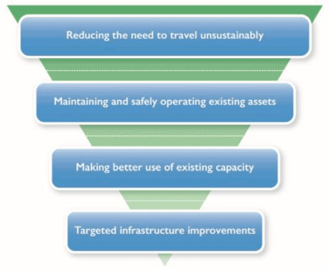
Graphic text below:
- Reducing the need to travel unsustainably
- Maintaining and safely operating existing assets
- Making better use of existing capacity
- Targeted infrastructure improvements

Graphic text below:
Prioritising Sustainable Transport
- Walking and wheeling
- Cycling
- Public transport
- Taxi & shared transport
- Private car
Liveable places
14. Design, quality and place
Legislative requirements |
||
Considerations of development planning sections of the Act or the Regulations |
Other statutory requirements |
|
|
||
NPF4 policy advice - information likely required in taking account of NPF4 policy |
||
|
||
Other information planning authorities may wish to: prepare, or review for spatial implications |
||
|
||
Relevant sources of information |
||
Policies / strategies / plans / guidance / designations |
Data sets / spatial data resources |
|
|
|
|
Key policy connections |
||
All other policies. |
||
Considerations |
||
The Evidence Report can include information about the quality of existing places, in reference to the six qualities of successful places as described in NPF4. It will be useful to develop an understanding of how local places are experienced in the context of wider data about socio-economic and environmental characteristics. A place-based approach which identifies the links between design, quality and place and other topical policy areas will support this. |
||
15. Local living and 20 minute neighbourhoods
Legislative requirements |
||
Considerations of development planning sections of the Act or the Regulations |
Other statutory requirements |
|
|
||
NPF4 policy advice - information likely required in taking account of NPF4 policy |
||
|
||
Other information planning authorities may wish to: prepare, or review for spatial implications |
||
|
||
Relevant sources of information |
||
Policies / strategies / plans / guidance / designations |
Data sets / spatial data resources |
|
|
||
Key policy connections |
||
1, 2, 13, 14, 16, 18, 20, 21, 25, 27, 28. |
||
Considerations |
||
The approach to local living and 20 minute neighbourhoods is flexible. It can be adapted to support communities in ways that best meet their needs and capitalise on local assets. A robust understanding of the current circumstances of a place is essential to its realisation. The local living approach is cross-cutting, and consideration of evidence from across NPF4 policy areas as a whole will contribute to this understanding. Places that support local living principles, including 20 minute neighbourhoods, take into account the local circumstances of a place; the varying settlement patterns, level and quality of interconnectivity, and the particular challenges faced. Place-based LDPs should apply the Place Principle, progressing alignment between the strategies, actions and investment portfolios that inform local living, from within local and national park authorities and across sectors. At the Evidence Report stage this could take the form of cross-referencing of other work underway to support local liveability. Quantitative and qualitative information may be used to inform the Evidence Report. Planning authorities are not expected to collect this information as primary data. Where the collation of fresh primary data is appropriate qualitative information can be gathered using tools such as the Place Standard and through new community engagement exercises and review of previous engagement exercises. It is important not to consider the existence of the services, facilities and assets in a place in isolation, but alongside information about their quality, how they operate and complement other features within the neighbourhood and also how they connect to higher order services (universities, hospitals etc.) to create networks of 20 Minute Neighbourhoods. Engagement is a critical component in gaining a full understanding of a place. Communities and businesses will have an important role to play in informing local living, particularly in rural areas. |
||

Graphic text below:
People
Movement
- Moving Around
- Public Transport
- Traffic and Parking
Space
- Streets and Spaces
- Natural Space
- Play and Recreation
Resources
- Support and Services
- Work and Local Economy
- Housing and Community
- Social Interaction
Civic
- Identity and Belonging
- Feeling Safe
Stewardship
- Care and Maintenance
- Influence and Sense of control
16. Quality homes
Legislative requirements |
||
Considerations of development planning sections of the Act or the Regulations |
Other statutory requirements |
|
Have regard to:
A Delivery Programme is to set out the following matters:
|
|
|
NPF4 policy advice - information likely required in taking account of NPF4 policy |
||
|
||
Other information planning authorities may wish to: prepare, or review for spatial implications |
||
Relevant sources of information |
||
Policies / strategies / plans / guidance / designations |
Data sets / spatial data resources |
|
|
||
Key policy connections |
||
1, 2, 8, 9, 13, 14, 15, 17, 18, 19, 20, 21, 23, 27. |
||
Considerations |
||
NPF4 promotes an ambitious and plan-led approach for new homes. Providing land to accommodate a wide choice of homes across a range of scales of sites and locations will enable this. The Evidence Report is expected to:
The planning authority's views on the matters listed under Section 15(5) of the Act are expected to inform the LHLR which will provide a target for meeting housing needs of people living in the area as required by Section 15(1A). Planning authorities may wish to consider the following information when proposing an indicative LHLR. Minimum All-Tenure Housing Land Requirement (MATHLR) NPF4 Annex E provides a 10-year MATHLR for each planning authority area. Planning authorities must take this into account in arriving at their indicative LHLR. It is expected that the MATHLR is the minimum amount of land for housing to be included within LDPs, and that the LHLR will exceed the MATHLR. The MATHLRs are evidence based: they combine considerations of past trends with future projections and policy ambitions, along with balancing national data with local information and knowledge. The same evidence can be used by the planning authority to inform their indicative LHLR as that used to inform the MATHLR. However, where more recent information is available this should be used as it enables the Evidence Report to be more up-to-date in looking to the future, for example updated household projections, local need figures or a relevant change in local, regional or national policy. This replaces the previous process requiring consistency with a strategic plan that was prepared a number of years previously. Background to the NPF4 MATHLR figures, including assessments for individual planning authorities, can be found online. HNDA It is expected that the HNDA process will be completed in full, in line with published Scottish Government guidance, prior to the Evidence Report being submitted for Gate Check. Where the Scottish Government (Centre for Housing Market Analysis) is satisfied that the HNDA is robust and credible, the approach used will not normally need to be considered further at the Gate Check. Where stakeholders consider further evidence may be relevant after a robust and credible HNDA has been achieved, this may be raised in engagement, reflected in the Evidence Report and it is at the discretion of the reporter to consider whether a request for further information is appropriate. While HNDAs will cover Housing Market Areas (HMAs), there is no longer a requirement for the LHLR within LDPs to refer to HMAs. The Evidence Report should also be informed by the following planning and housing information: HLAs will provide information on past completions and future programming of new homes for the plan area. The list of persons seeking to acquire land for self-build housing (section 16E of the Act), will provide an indication of the demand for self-build in the plan area. A windfall assumption will take account of those sites which become available for development unexpectedly during the life of the LDP and so are not identified individually in the plan. Any assessment of the expected contribution of windfall sites to the indicative LHLR must be realistic and based on clear evidence of past completions and sound assumptions about likely future trends. Regard must be given to the LHS. This will, in particular, provide relevant information relating to different tenures of affordable and market housing for an area. This should inform the process of setting the all-tenure LHLR. The most recent Strategic Housing Investment Plan (SHIP), which is an operational document, will provide information on local authority housing investment priorities and projects relating to affordable housing and Gypsy/Traveller accommodation. An authority may wish to take account of the proportion of ineffective stock relating to second homes, vacant properties and housing used for short term letting (holiday accommodation) within their area. This can be a locationally concentrated issue within an authority area and does not generally accommodate existing housing need. It could therefore be a local factor for increasing the LHLR. The Evidence Report should be informed by the views of the Gypsy / Traveller and Travelling Showpeople community and other information on their accommodation needs identified in the HNDA and the LHS. Their views should be actively sought, and it may also be helpful to engage with neighbouring authorities on this. Stakeholders expected to be engaged in the preparation of housing related evidence for the Evidence Report include:
In assessing the Evidence Report at the Gate Check, the reporter is expected to take a view on whether there is sufficient information in the Evidence Report to establish the indicative LHLR. |
||
17. Rural homes
Legislative requirements |
||
Considerations of development planning sections of the Act or the Regulations |
Other statutory requirements |
|
have regard to
|
|
|
NPF4 policy advice - information likely required in taking account of NPF4 policy |
||
|
||
Other information planning authorities may wish to: prepare, or review for spatial implications |
||
|
||
Relevant sources of information |
||
Policies / strategies / plans / guidance / designations |
Data sets / spatial data resources |
|
|
|
|
Key policy connections |
||
1, 2, 4, 7, 8, 9, 10, 13, 14, 15, 16, 18, 27, 29, 30 |
||
Considerations |
||
The information for the Evidence Report in relation to rural homes will be similar to the information outlined for the Quality Homes section above. Particular rural elements will relate to the consideration of areas where there has been a substantial decline in population and where there may be a desirability of allocating land for resettlement. To prepare a plan that is informed by an understanding of population change over time, locally specific needs and market circumstances in rural areas, the Evidence Report can consider National Records of Scotland (NRS) data on population estimates. The Scottish Government 6 fold Urban Rural Classification 2020 provides a consistent way of defining such areas based on population (NRS information) and accessibility (based on drive time to an urban area). However, finer grained, local classifications can be used to ensure that rural housing approaches are locally tailored to reflect local circumstances. |
||
18. Infrastructure first
Legislative requirements |
||
Considerations of development planning sections of the Act or the Regulation |
Other statutory requirements |
|
Have regard to:
|
||
NPF4 policy advice - information likely required in taking account of NPF4 policy |
||
|
||
Other information planning authorities may wish to: prepare, or review for spatial implications |
||
|
||
Relevant sources of information |
||
Policies / strategies / plans / guidance / designations |
Data sets / spatial data resources |
|
|
|
|
Key policy connections |
||
1, 2, 3, 9, 11, 12, 13, 14, 15, 16, 17, 19, 20, 21, 22, 23, 24, 26, 27, 29. |
||
Considerations |
||
An infrastructure first approach should underpin all aspects of plan making, with infrastructure considerations at the heart of place making. This means undertaking early engagement, evidence gathering and where possible data sharing, including with public and private infrastructure providers. This approach also offers potential benefits for infrastructure providers with regard to informing their own plans and strategies. The Evidence Report may reference baseline infrastructure information and data including:
The infrastructure evidence can be used to inform early thinking on the spatial strategy. Where available, evidence on the resilience of infrastructure assets to climate risks may be helpful. The evidence may also support more sustainable use of infrastructure, in line with the Infrastructure Investment Plan and NTS2 sustainable investment hierarchies, and Scotland's transition to net zero. Assessment of infrastructure capacity, condition and future provision at this stage can inform the early development of the spatial strategy. For example, broad areas of infrastructure constraint or capacity can indicate where there is scope for future growth in line with the infrastructure investment hierarchy, or where intervention will be required to support future development. Stakeholders expected to inform the preparation of the Evidence Report are:
The use of forums for collaborating with public and private infrastructure providers may also be useful for all parties in securing and sharing information to inform infrastructure planning. Where it is not possible for infrastructure providers or other stakeholders to share sensitive information about infrastructure capacity, constraints and planned improvements, the use of a 'Red Amber Green' system may enable some understanding of the area baseline. |
||

Graphic text below:
New Scottish Government Investment Hierarchy
Determine future need
Consider appropriate infrastructure needs and demand in light of net zero carbon and inclusive growth priorities, changes in service design, availability of digital platforms and technological innovation, and resilience in light of population and climate change forecasts.
Maximise the useful life of existing assets
Maximise adaptation, repair and maintenance of existing assets.
Repurpose & Co-locate
Reconfigure or repurpose existing assets, giving preference to co-location or shared facilities.
Replace, Create or Build New Assets
Consider suitability and sustainability of new assets.
19. Heat and cooling
Legislative requirements |
||
Considerations of development planning sections of the Act or the Regulations |
Other statutory requirements |
|
|
||
NPF4 policy advice - information likely required in taking account of NPF4 policy |
||
|
||
Other information planning authorities may wish to: prepare, or review for spatial implications |
||
|
||
Relevant sources of information |
||
Policies / strategies / plans / guidance / designations |
Data sets / spatial data resources |
|
|
||
Key policy connections |
||
1, 2, 11, 12, 13, 18, 20, 26. |
||
Considerations |
||
LHEES will be the principal mechanism for locally-led, area based heat planning in Scotland. They will also provide an evidence base to support action to decarbonise heat, improve energy efficiency and tackle fuel poverty. LHEES have an important role in identifying potential heat networks. Section 47 of the Heat Networks (Scotland) Act 2021 places a duty on local authorities to carry out a review to consider whether one or more areas in its area is likely to be particularly suitable for the construction and operation of a heat network. LHEES provide an approach to discharge this duty. Planning authorities can use LHEES and the Scotland Heat Map to inform the potential for co-locating developments with a high heat demand together with or alongside sources of heat supply. Heat supply could include potential low-grade heat from geothermal sources, water bodies, including aquifers, rivers, lochs, and tidal waters in coastal areas. Sources of heat supply might also include heat recovered from surplus or waste heat sites, such as the waste water treatment sector. Local authorities are required to publish their first LHEES by the end of 2023 and then update them on a five-yearly basis. |
||
20. Blue and green infrastructure
Legislative requirements |
||
Considerations of development planning sections of the Act or the Regulations |
Other statutory requirements |
|
Have regard to:
|
|
|
NPF4 policy advice - information likely required in taking account of NPF4 policy |
||
|
||
Other information planning authorities may wish to: prepare, or review for spatial implications |
||
|
||
Relevant sources of information |
||
Policies / strategies / plans / guidance / designations |
Data sets / spatial data resources |
|
Key policy connections |
||
1, 2, 11, 12, 13, 18, 20, 26. |
||
Considerations |
||
A blue and green infrastructure audit can reflect and bring together relevant assessments, audits, strategies and action plans, including those prepared under statutory duties, such as Open Space Strategies, Forestry and Woodland Strategies and Play Sufficiency Assessments. It can identify existing blue and green infrastructure and their networks, including access rights and core paths, and areas with an important role in flood water storage or conveyance as informed by a Strategic Flood Risk Assessment (SFRA) for the area. Priorities for connectivity to other blue and/or green infrastructure assets, including to address cross-boundary needs and opportunities, can also be identified. |
||
21. Play, recreation and sport
Legislative requirements |
||
Required by development planning sections of the Act, or development planning Regulations |
Other statutory requirements |
|
The Town and Country Planning (Play Sufficiency Assessment)(Scotland) Regulations 2023 set out the form and content of the Play Sufficiency Assessment (PSA); the persons who must be consulted in preparing the PSA; and the publication of the PSA. Have regard to:
|
||
NPF4 policy advice - information likely required in taking account of NPF4 policy |
||
|
||
Other information planning authorities may wish to: prepare, or review for spatial implications |
||
|
||
Relevant sources of information |
||
Policies / strategies / plans / guidance / designations |
Data sets / spatial data resources |
|
|
||
Key policy connections |
||
1, 2, 3, 4, 6, 7, 8, 9, 13, 14, 15, 16, 17, 18, 19, 20, 22, 23, 27, 31. |
||
Considerations |
||
Sports pitch / playing pitch / field strategies, where available, can also inform existing and potential new provisions for play, recreation and sport opportunities. |
||
22. Flood risk and water management
Legislative requirements |
||
Considerations of development planning sections of the Act or the Regulation |
Other statutory requirements |
|
Have regard to:
|
||
NPF4 policy advice - information likely required in taking account of NPF4 policy |
||
|
||
Other information planning authorities may wish to: prepare, or review for spatial implications |
||
|
||
Relevant sources of information |
||
Policies / strategies / plans / guidance / designations |
Data sets / spatial data resources |
|
|
|
|
Key policy connections |
||
1, 2, 3, 8, 10, 14, 16, 18, 20, 23, 26. |
||
Considerations |
||
The Evidence Report can reference a Strategic Flood Risk Assessment (SFRA). SFRAs are designed to inform the development planning process, primarily to avoid increasing overall flood risk by avoiding areas of flood hazard. They are prepared by the planning authority in consultation with Scottish Environment Protection Agency (SEPA). For planning purposes, at risk of flooding or in a flood risk area means land or built form with an annual probability of being flooded of greater than 0.5% which must include an appropriate allowance for future climate change. Such areas, including any significant cross boundary flooding and water issues, as identified by the relevant SFRA, can be referenced in the Evidence Report to inform choices about appropriate locations for development during LDP preparation. The Evidence Report can also have regard to the flood maps prepared by SEPA, and must consider relevant finalised and approved flood risk management plans and river basin management plans. River basin management plans set out a framework for protecting and improving the benefits provided by the water environment across Scotland. They focus on reducing resource use, eliminating waste and restoring natural capital. They cover rivers, lochs, transitional waters (estuaries), coastal waters groundwater, and groundwater dependant wetlands, and set out actions for public bodies, industry and land managers in Scotland. |
||
23. Health and safety
Legislative requirements |
||
Considerations of development planning sections of the Act or the Regulations |
Other statutory requirements |
|
Have regard to:
|
||
NPF4 policy advice - information likely required in taking account of NPF4 policy |
||
|
||
Other information planning authorities may wish to: prepare, or review for spatial implications |
||
|
||
Relevant sources of information |
||
Policies / strategies / plans / guidance / designations |
Data sets / spatial data resources |
|
|
|
|
Key policy connections |
||
1, 2, 6, 11, 12, 13, 14, 15, 16, 18, 19, 20, 21, 22, 24, 26, 27, 28, 31, 32, 33. |
||
Considerations |
||
A place-based approach can support improved health outcomes and address health inequalities. While some indicators have differing significance for urban and rural areas, the evidence collated in respect of a range of NPF4 policies can contribute to understanding the health and wellbeing of the community. Reference may be made to baseline information regarding the physical and mental health and wellbeing of the population. The Scottish Government's public health priorities may help frame the evidence gathering. Identification of gaps in provision of facilities, services or amenities will be important. The Evidence Report should be informed by, but should not publish, information that may identify locations of concern for suicide. Environmental factors and physical amenities which influence health and wellbeing can include: the nature and distribution of poor air quality, (including but not limited to Air Quality Management Areas); noise (including quiet areas and noise action plan areas); odour; lighting; and green and blue infrastructure. Food environment evidence may include: food availability and food deserts; food outlet clusters; local and community food growing; food markets; market gardens; and non-agricultural commercial food growing. Engagement with Health Boards and Health and Social Care Partnerships will be important, regarding the provision of health care services or facilities. The Evidence Report should reference evidence on particular hazards to people and the environment as detailed above. Mine gases are hazardous to human health. Therefore, in those areas within Scotland where coal mining has taken place in the past, planning authorities are expected to review the relevant maps produced by the Coal Authority that indicate where there are 'development high risk areas', and make reference to these in the Evidence Report. Other environmental or pollutant characteristics may be particularly relevant to an area, for example land that has been contaminated, and where known this may be referenced by the Evidence Report. |
||
24. Digital infrastructure
Legislative requirements |
||
Considerations of development planning sections of the Act or the Regulations |
Other statutory requirements |
|
|
||
NPF4 policy advice - information likely required in taking account of NPF4 policy |
||
|
||
Other information planning authorities may wish to: prepare, or review for spatial implications |
||
Relevant sources of information |
||
Policies / strategies / plans / guidance / designations |
Data sets / spatial data resources |
|
|
||
Key policy connections |
||
1, 4, 8, 12, 14, 15, 18, 23, 25, 26, 27, 29. |
||
Considerations |
||
NPF4 facilitates the roll out of digital infrastructure, helping to reduce the need to travel, and supports investment and population growth in rural areas by specifically addressing the digital divide to ensure no areas are left behind. The Evidence Report can be informed by the views of wider local and planning authority departments, such as economic development, as well as the Mobile Network Operators (MNOs) and Wireless Infrastructure Providers (WIPs) in relation to programmed investment in digital infrastructure within the area. |
||
Productive places
25. Community wealth building
Legislative requirements |
||
Considerations of development planning sections of the Act or the Regulations |
Other statutory requirements |
|
|
||
NPF4 policy advice - information likely required in taking account of NPF4 policy |
||
|
||
Other information planning authorities may wish to: prepare, or review for spatial implications |
||
|
||
Relevant sources of information |
||
Policies / strategies / plans / guidance / designations |
Data sets / spatial data resources |
|
|
||
Key policy connections |
||
9, 15, 26. |
||
Considerations |
||
Local authorities will be various stages of development with their rolling Community Wealth Building (CWB) strategies and action plans. Such strategies will be part of, or form, that authority's overall economic plan. Informed by these strategies, the Evidence Report can identify community asset transfers in progress and/or being explored. Use of the Community Wealth Building model can also shape more general development of a local economy that seeks to retain more wealth in communities. In this way, creation of a more 'wellbeing' focused local economy can be assisted. To inform this, local economic statistics on employment, key sectors, and investment land and sites are likely to be relevant to the Evidence Report. The Evidence Report can identify the planning authority's CWB priorities, as laid out in their CWB strategy, that will be relevant to consider in the preparation of the LDP. |
||

Graphic text below:
Community Wealth Building is a practical approach to local economic development that supports the delivery of a wellbeing economy for Scotland. It delivers actions that give the people of Scotland a greater stake in our economy and wealth, making it work for us and our planet.
Inclusive Ownership:
Developing more local and social enterprises which generate community wealth, including social enterprises employee owned firms and co-ops.
Workforce:
Increasing fair work and developing local labour markets that support the wellbeing of communities.
Finance:
Ensuring that flows of investment and financial institutions work for local people, communities and businesses.
Land and property:
Growing the social, ecological, financial and economic value that local communities gain from land and property assets.
Spending:
Maximising community and business benefits through procurement and commissioning, developing good enterprises, fair work and shorter supply chains.
26. Business and industry
Legislative requirements |
||
Considerations of development planning sections of the Act or the Regulations |
Other statutory requirements |
|
|
||
NPF4 policy advice - information likely required in taking account of NPF4 policy |
||
|
||
Other information planning authorities may wish to: prepare, or review for spatial implications |
||
|
||
Relevant sources of information |
||
Policies / strategies / plans / guidance / designations |
Data sets / spatial data resources |
|
Key policy connections |
||
1, 2, 13, 14, 15, 23, 24, 25, 27, 29. |
||
Considerations |
||
Business and Industry Land Audits can monitor the location, size, planning status, existing use, neighbouring land uses and any significant land use issues (e.g. underused, vacant, derelict) of sites within the existing business and industry land supply. Identifying the principle economic characteristics of the area is likely to require use of the up-to-date market intelligence and demand forecasting that also informs local economic strategies. The Evidence Report may refer to analysis of employment need, local poverty, disadvantage and inequality, to identify where future business and industry development may provide most benefit. |
||
27. City, town, commercial and local centres
Legislative requirements |
||
Considerations of development planning sections of the Act or the Regulations |
Other statutory requirements |
|
|
||
NPF4 policy advice - information likely required in taking account of NPF4 policy |
||
|
||
Other information planning authorities may wish to: prepare, or review for spatial implications |
||
|
||
Relevant sources of information |
||
Policies / strategies / plans / guidance / designations |
Data sets / spatial data resources |
|
Key policy connections |
||
1, 2, 7, 9, 13, 14, 15, 16, 18, 20, 21, 23, 25, 26, 28, 29, 30, 31. |
||
Considerations |
||
Audits of existing centres can help to harness their strengths, support vitality and viability, tackle weaknesses and identify action to improve resilience. Planning authorities can work with community planning partners, businesses and community groups as appropriate to prepare and agree what should be audited and measured about a particular centre. The principles of local living and 20 minute neighbourhoods may provide context for this, supporting a goal of thriving centres that meet the needs of the community. The Place Standard tool may also be useful in this regard. To inform the Evidence Report, as part of the auditing of town centres and resulting strategies, planning authorities can gather information on:
Audits will benefit from being regularly updated, to monitor progress towards the identified place specific ambitions, preferably every two years. |
||
28. Retail
Legislative requirements |
||
Considerations of development planning sections of the Act or the Regulations |
Other statutory requirements |
|
|
||
NPF4 policy advice - information likely required in taking account of NPF4 policy |
||
|
||
Other information planning authorities may wish to: prepare, or review for spatial implications |
||
|
||
Relevant sources of information |
||
Policies / strategies / plans / guidance / designations |
Data sets / spatial data resources |
|
Key policy connections |
||
1, 2, 13, 14, 15, 23, 27, 29. |
||
Considerations |
||
Planning authorities can consider if there is need for a retail study to identify where there may be a need for further retail provision. Data on the type and distribution of retail facilities will be relevant. It may be useful for the Evidence Report to assess the nature of the food environment in the area, including the diversity and availability of food through retail and how it is or is not contributing towards healthy diet and weight in the area. There will potentially be links between this and information covered in respect of policy 23. |
||
29. Rural development
Legislative requirements |
||
Considerations of development planning sections of the Act or the Regulations |
Other statutory requirements |
|
|
||
NPF4 policy advice - information likely required in taking account of NPF4 policy |
||
|
||
Other information planning authorities may wish to: prepare, or review for spatial implications |
||
Relevant sources of information |
||
Policies / strategies / plans / guidance / designations |
Data sets / spatial data resources |
|
|
||
Key policy connections |
||
1, 2, 4, 5, 7, 8, 9, 10, 13, 14, 15, 17, 18, 20, 22, 26, 27, 28, 30, 31, 32, 33. |
||
Considerations |
||
Any locally tailored classifications of rural areas should use the framework provided by the Urban Rural Classification 2020 for remote rural areas, including Islands and Sparsely Populated Areas. A classification system may also identify the rural population distribution and demographic profile, including, where relevant, areas where there has been a substantial decline in population over time. The Evidence Report can use relevant data sets and local knowledge to identify existing patterns of development, pressures and environmental assets. |
||
30. Tourism
Legislative requirements |
||
Considerations of development planning sections of the Act or the Regulations |
Other statutory requirements |
|
|
||
NPF4 policy advice - information likely required in taking account of NPF4 policy |
||
|
||
Other information planning authorities may wish to: prepare, or review for spatial implications |
||
|
||
Relevant sources of information |
||
Policies / strategies / plans / guidance / designations |
Data sets / spatial data resources |
|
|
||
Key policy connections |
||
1, 2, 4, 7, 10, 13, 14, 16, 17, 23, 25, 27, 28, 29, 31. |
||
Considerations |
||
The Evidence Report can reference any relevant national and local sector driven tourism strategies and identify any key spatial issues. The Evidence Report can help to identify issues affecting the resilience of the tourism sector in the area, such as environmental, cultural and community assets, as well as the availability of tourism accommodation and associated infrastructure considerations. |
||
31. Culture and creativity
Legislative requirements |
||
Considerations of development planning sections of the Act or the Regulations |
Other statutory requirements |
|
|
||
NPF4 policy advice - information likely required in taking account of NPF4 policy |
||
|
||
Other information planning authorities may wish to: prepare, or review for spatial implications |
||
|
||
Relevant sources of information |
||
Policies / strategies / plans / guidance / designations |
Data sets / spatial data resources |
|
Key policy connections |
||
1, 2, 7, 9, 12, 13, 14, 15, 20, 21, 23, 24, 25, 27, 29, 30. |
||
Considerations |
||
The Evidence Report can be informed by any relevant Creative Scotland plans and strategies, together with any local plans and strategies which address the area's culture and creativity. This can include consideration of the existing location, range and health of facilities and venues, as well as aspirations to add to the range of art or cultural venues in a place. |
||
32. Aquaculture
Legislative requirements |
||
Considerations of development planning sections of the Act or the Regulations |
Other statutory requirements |
|
Have regard to:
|
||
NPF4 policy advice - information likely required in taking account of NPF4 policy |
||
|
||
Other information planning authorities may wish to: prepare, or review for spatial implications |
||
|
||
Relevant sources of information |
||
Policies / strategies / plans / guidance / designations |
Data sets / spatial data resources |
|
|
|
|
Key policy connections |
||
1, 3, 4, 7, 10, 14, 23, 25, 26, 29. |
||
Considerations |
||
Where the aquaculture industry is active in their area, planning authorities can reference in the Evidence Report information to guide sustainable investment and support the industry. Data is available from planning registers, Marine Scotland's database and SEPA. Planning authorities may also wish to work with the industry in gathering relevant data. In relevant areas the Evidence Report may be informed by:
|
||
33. Minerals
Legislative requirements |
||
Considerations of development planning sections of the Act or the Regulations |
Other statutory requirements |
|
|
||
NPF4 policy advice - information likely required in taking account of NPF4 policy |
||
|
||
Other information planning authorities may wish to: prepare, or review for spatial implications |
||
Relevant sources of information |
||
Policies / strategies / plans / guidance / designations |
Data sets / spatial data resources |
|
|
||
Key policy connections |
||
1, 3, 4, 7, 12, 18, 23. |
||
Considerations |
||
The Evidence Report may include information that can demonstrate if the planning authority is capable of meeting at least a 10 year landbank of construction aggregate in relevant market areas. Relevant types of information include:
In areas where there is a history of being reliant on other planning authorities to help meet their construction aggregate future needs, it is for the planning authority to determine how best to provide evidence that these future supply chains are capable of meeting future demand. |
||
Gate Check
Purpose
127. The assessment of the Evidence Report, known as the Gate Check, will provide an independent assessment of whether the planning authority has sufficient information to prepare an LDP. It will be carried out by a person appointed by the Scottish Ministers, usually a reporter from the DPEA. The reporter may decide there is sufficient information, and, on being so notified, the planning authority may then move to prepare and publish their Proposed Plan, or the reporter may consider there is not sufficient information and provide recommendations for improving the Evidence Report. The Gate Check process should reduce the level of debate arising at the Examination at the end of the plan preparation period, and make for a better evidence-led plan.
Legislative requirements
128. Legislative requirements in relation to Gate Checks are covered in both the Act and the Regulations. Details of the requirements are set out below.
Submission of Evidence Report
Once a planning authority has approved its Evidence Report, it is to submit it to the Scottish Ministers. - section 16B(7)
Appointed person
The Scottish Ministers must then appoint 'a person to assess whether the report contains sufficient information to enable the planning authority to prepare a LDP'. - section 16B(8)
As soon as practicable after appointing a person to assess an Evidence Report the Scottish Ministers must notify the authority that such an appointment has been made and of the name of the appointed person. - regulation 3
Documentation
Within 14 days of receiving notification under regulation 3 the planning authority must, to the extent that they have not already done so, make available to the appointed person a copy of any document referred to in the Evidence Report. - regulation 5(2)
Procedure
The procedure to be followed in a Gate Check is at the discretion of the appointed person, subject to requirements in regulations 5 (2) and (3).
At any stage of the Gate Check the appointed person may request further information. Where to inform their assessment, the appointed person determines that representations should be made or information should be provided by any person in connection with the assessment of the Evidence Report. The appointed person may by notice request that person to make such representations or to provide such information. - regulation 5(1), regulations 5(3) and (4)
Appointed person's findings/ Assessment Report
Where the appointed person considers the Evidence Report contains sufficient information, they must inform the planning authority and the Scottish Ministers accordingly. - section 16B(9)
Where the appointed person is not satisfied that there is sufficient information in the Evidence Report, they are to:
- prepare an "Assessment Report" setting out the reasons for not being so satisfied and recommendations for improving the Evidence Report; and
- send a copy of the Assessment Report to the planning authority and the Scottish Ministers. - section 16B(10)
Resubmitted Evidence Reports
On receiving an Assessment Report, a planning authority must revise its Evidence Report, and resubmit it to the Scottish Ministers. - section 16B(11)
The same process as above is then followed again for resubmitted Evidence Reports. - section 16B(12)
Expenses of Assessment
The general administrative costs, staff costs (including any remuneration due to the appointed person) and overheads (including the costs of provision of a venue) incurred by the Scottish Ministers or the appointed person in relation to Gate Check are to be met by the planning authority. - regulation 6
Implementation
129. The purpose of the Gate Check is to confirm the evidence base on which the Proposed Plan will be developed is sufficient. The scope of the Gate Check is set in the Act section 16B(8), which identifies that the role of the appointed person is to assess the sufficiency of the information to enable the planning authority to prepare a LDP. It is expected a proportionate approach will be taken in considering sufficiency. This may reflect the issues that are likely to be most contentious or key components of the Proposed Plan and its delivery (such as housing, transport and infrastructure). The Gate Check should not be seen as a mini or early Examination.
130. The previous section 'advice on relevant evidence for NPF4 policy topics' provides further information on specific evidence requirements linked to legislative provisions and for NPF4 policy matters. However, this is not exhaustive and relevant evidence will depend on the issues relevant to a particular LDP. It will be for the reporter to identify whether there are any gaps in evidence which should be addressed. Planning authorities should aim to ensure that they are satisfied their Evidence Report contains sufficient information before submitting for the Gate Check.
131. The requirement for submission to the Scottish Ministers can be met by submitting the Evidence Report to the DPEA. Any document referred to in the Evidence Report is to be made available to the appointed person. In preparing to submit their Evidence Report to the Scottish Ministers planning authorities should consider their document management approach. The DPEA will provide guidance to planning authorities on submitting and presenting information for their Gate Check.
132. As set out in the guidance on Evidence Reports stakeholder engagement in the preparation of the Evidence Report is vital so that their views on the sufficiency of information can be taken into account. Planning authorities should ensure they record details of discussions or written exchanges with stakeholders, on the evidence, so this can be reviewed by the appointed person.
133. The reporter will be led by the evidence before them. Where the planning authority indicates, in the 'Statements of agreement and disputes' part of the Evidence Report, there is agreement between stakeholders about the sufficiency of the evidence, it is unlikely to be necessary for the reporter to take a look at the issue in depth. However, they will look for the evidence of engagement, which is expected to be shown within the 'Summary of Stakeholder Engagement' and 'Statements of agreement and disputes' parts of the Evidence Report that the relevant stakeholders and key agencies have been involved for their interests.
134. The legislative process does not envisage additional information being sent to Scottish Ministers or the appointed person, at the Gate Check stage, unless the appointed person specifically requests further information is provided.
135. Where disputes over the sufficiency of the evidence remain, the Gate Check provides an opportunity for the reporter to consider the different viewpoints and come to a view. This may be informed either by requesting further written information or by convening a hearing. It is expected that the majority of assessments will be carried out using written submissions, with a hearing only used where a particularly complex dispute is identified.
136. Where there are disputes over the evidence, the reporter will take into account what this guidance says on the types of information different types of evidence may cover.
137. Following their assessment of the Evidence Report, where the appointed person considers the Evidence Report, either:
a) contains sufficient information, they must inform the planning authority and the Scottish Ministers accordingly. In such circumstances, there is no requirement for the appointed person to prepare a report, however it is expected that the appointed person will prepare a letter, which includes their reasoning for finding the information to be sufficient; or
b) does not contain sufficient information they must prepare an "Assessment Report" setting out the reasons for not being so satisfied and recommendations for improving the Evidence Report, and send a copy to the planning authority and the Scottish Ministers.
Responsibilities
138. The person appointed by the Scottish Ministers has the responsibility for carrying out the Gate Check. To discharge this responsibility, they will need to communicate with the relevant planning authority, and the other stakeholders involved in the preparation of the Evidence Report.
Bigger picture
139. The Gate Check and Examination have an important relationship but these are two distinct processes with different purposes. The Gate Check will inform the Examination, but it should not be necessary for the sufficiency of the evidence base to be revisited at the Examination, which is to focus on unresolved issues arising from the plan. The Examination is not an opportunity to revisit the Evidence Report.
140. The preparation of the Proposed Plan should be closely informed by the baseline evidence in the Evidence Report. Planning authorities should therefore aim to move quickly from successfully completing the Gate Check to preparation of the Proposed Plan.
Proposed Plans – process
Purpose
141. The Proposed Plan should identify where new development should take place and where it should not. It can articulate the ambitions and priorities for the future development of the plan area. It should support coordination of development and service provision. An Infrastructure First approach should inform its preparation and support its delivery.
142. LDPs are expected to be place-based: there should be greater emphasis on maps, development briefs and masterplans. The reader should be able to find what is relevant to a particular place in one area of the plan. It is envisaged that the policies and proposals within the LDP are focused on places and locations.
Legislative requirements
143. Legislative requirements in relation to Proposed Plans are covered in both the Act and the Regulations. Details of the requirements are set out below.
Preparation
In preparing the Proposed Plan the planning authority must have regard to the Evidence Report that has successfully completed the Gate Check stage. - section 18(1)(a)
Key Agencies
Key agencies have a duty to cooperate with a planning authority in the preparation of the Proposed Plan - section 18(10)
Key agencies are those set out in the Regulations. - regulation 25
Community engagement
Planning authorities must have regard to any guidance issued to them by the Scottish Ministers in relation to effective community engagement. - section 16C
They must also promote and facilitate the participation of children and young people under the age of 25 in their preparation of the Proposed Plan. - section 16A(1)
As a starting point, this must include schools, youth councils and youth parliament representatives within the authority area. - section 16A(2)
The planning authority must publish and maintain up to date information about how children and young people have been involved in LDP preparation. - section 16A(3)
Information and considerations
In preparing the LDP planning authorities:
- have a duty to have regard to their adopted RSS; and - section 4ZB(2)
- must take into account the plans listed below:
- the National Planning Framework;
- any LOIP for the area; and
- any registered LPP for the area. - section 16(2)(a)
In preparing the LDP planning authorities must have regard to the following matters:
- the desirability of preserving disused railway infrastructure for the purpose of ensuring its availability for possible future public transport infrastructure; and - section 16(2)(aa)
- the list of people in the authority's area seeking land for self-build housing. - section 16(2)(ab)
Planning authority are also to have regard to 'such information and considerations as may be prescribed'. - section 16(2)(b) and
These are:
- any RSS prepared for the LDP area or an area adjoining the LDP area;
- any LDP prepared for a different purpose for the LDP area;
- any LDP prepared for an area adjoining the LDP area;
- where the LDP area adjoins land in England, any document which forms part of the development plan[1] for the area in which that land is situated; - regulation 9 (2)(a)-(d)
- the following plans and strategies, insofar as relating to the LDP area:
- the national waste management plan
- the national marine plan
- any regional marine plan
- any river basin management plan
- any flood risk management plan
- any local flood risk management plan
- any regional transport strategy
- any local transport strategy
- any LHS
- any open space strategy; - regulation 9 (2)(e)
- preventing major accidents and limiting the consequences of such accidents for human health and the environment; - regulation 9 (2)(f)
- the need in the long term:
- to maintain appropriate safety distances between residential areas, buildings and areas of public use, recreational areas and, as far as possible, major transport routes and
- establishments covered by the Directive, (Directive 96/82/EC of the European Council on the control of major accident hazards involving dangerous substances)
- major accident hazard pipelines
- to protect areas of particular natural sensitivity or interest in the vicinity of establishments or major accident hazard pipelines, where appropriate through appropriate safety distances or other relevant measures;
- in the case of existing establishments, to take additional technical measures in accordance with regulation 5 of the Control of Major Accident Hazards Regulations 2015 so as not to increase the risks to human health and the environment; - regulation 9 (2)(g)
- the resources available or likely to be available for the carrying out of the policies and proposals set out in the LDP. - regulation 9(2)(h)
Planning authorities may have regard to such other information and considerations that appear relevant to them. - section 16(2)(c)
Form and Content
Spatial strategy
LDPs are to set out a spatial strategy, being:
- a detailed statement of the planning authority's policies and proposals as to the development and use of the land, in the part of the district to which it relates, taking account of the section 15(5) matters;
- other matters as may be prescribed; and
- any other matters which the planning authority considers it appropriate to include. - section 15 (1), section 15(5)
Proposals Map
The LDP must include a proposals map or maps, to be known as the Proposals Maps that describes and illustrates the policies and proposals of the plan spatially. - regulation 7(1)
The Proposals Maps must be sufficiently detailed to enable the identification of the location of proposals for development and use of land. - regulation 7(2)
Housing Targets
LDPs must include targets for meeting the housing needs of people living in the part of the district to which it relates. - section 15 (1A)
Policies and proposals as to the provision of:
- public conveniences - section 15 (2A)
- water refill locations. - section 15 (2B)
Diagrams, illustrations and descriptive matter
LDPs are to contain or be accompanied by such diagrams, illustrations and descriptive matter (if any) as the planning authority considers appropriate for the purpose of explaining or illustrating the proposals in the plan. - section 15 (4)(b)
Other matters that the planning authority considers appropriate
The LDP can contain any other matter which the planning authority considers is appropriate to include. - section 15(1)(c)
Schedule of Land Ownership -
Where the LDP contains plans, policies or proposals for development on land owned by the planning authority, the plan must include as an appendix a Schedule which identifies that land, and references the relevant plans, policies or proposals. - section 15 (3)
The schedule of land ownership required to be appended to the plan by section 15(3) of the Act is to be in the form set out in Schedule 1 of the Regulations. - regulation 8(1) and Schedule 1.
Where a LDP is prepared by a National Park authority, the schedule of land ownership is also to include land owned by a local authority. - regulation 8(2)
Approval by Full Council
The Proposed Plan must be approved by the full Council before being published for consultation - section 18(1B)
This approval cannot be delegated to a committee or officer of the authority. - section 18(1C)
Consultation
The planning authority must consult with:
- the key agencies and - section 18(1)(d)
they must send to each key agency a copy of the Proposed Plan and the Evidence Report, - section 18(1)(b)
and
- the Scottish Ministers. - regulation 11
- Those planning authorities "for a district all or part of which falls within the boundary identified by the Central Scotland Green Network Partnership are (for so long as such a body is included in the National Planning Framework as a national development) to consult the Network on the Proposed LDP".
The Central Scotland Green Network Partnership's aims are currently delivered by the Green Action Trust. - section 18(1A)
Publication
- The Proposed Plan; - section 18(1)(a)
- the Evidence Report that supports it; and - section18(1)(aa)
- the proposed Delivery Programme
must be published by the planning authority at the same time. - section 21(4)
A notice must be published in a local newspaper circulating in the area and on the internet containing the following information:
- a statement that the proposed LDP has been prepared and where and at what times it may be inspected,
- a brief description of the content and purpose of the proposed LDP;
- details of how further information may be obtained regarding the proposed LDP, including that it is to be published on the internet;
- a statement that any person wishing to do so may make representations on the content of the proposed LDP; and
- information as to how and to whom any representations should be made. - regulation 10 (2)(a)
When publishing the proposed plan, the planning authority is to specify a date, not less than 12 weeks after the date of publication by which any representations in respect of the Proposed Plan must be made to the planning authority. - section 18 (2)
A notice containing that information must also be sent to:
- the key agencies;
- the Scottish Ministers;
- adjoining planning authorities to the plan area; and
- community councils any part of whose area is within the LDP area. - regulation 10 (2)(b)
A copy of the proposed LDP must be made available for inspection at an office of the planning authority and in every public library in the LDP area. - regulation 10 (2)(c)
The Proposed Plan must be published on the internet. - regulation 10 (2)(d)
Neighbour Notification
Notice must be given to the owner, lessee or occupiers of sites and neighbouring land that may be significantly affected by development proposals. - regulation 12(1)
Notice is to be in the form set out in Schedule 2 of the Regulations and be accompanied by a map showing the location of the site. - regulation 12(2)
"Neighbouring land" means land which is conterminous with or within 20 metres of the boundary of a specific site in respect of which a LDP includes a proposal for development. - regulation 12(3)
Modification
After the consultation period has ended, the planning authority can modify the Proposed Plan. In doing this they can take account of:
- representations made to them;
- any matters arising from consultation with key agencies and the Scottish Ministers; and
- any minor drafting or technical matters. - section 18(3)
If modifications are made, the planning authority must prepare a Modification Report setting out the modifications and the reasons for making them. - section 18(4)(a)(iii)
Implementation
Spatial strategy
144. A spatial strategy signals the direction of future spatial change in an area. It should actively guide development to locations that create and shape places, taking account of the spatial aspects of the NPF (including its spatial principles) and having regard to any relevant adopted RSS.
145. It should be expressed primarily as a visual that maps change, and go beyond the existing situation, to provide an indication of the place in 20 years' time. It is expected that specific proposals / land allocations will cover the first ten years, and that for the longer term (beyond ten years) the plan may identify broad areas with potential for development.
146. The spatial strategy can help the LDP to connect activities in the plan area and align investment across services and sectors over the long term.
Work to inform Proposed Plan
Preparation
147. NPF4 sets out that LDPs should be place-based and created in line with the Place Principle. The Place Principle promotes a collaborative place-based approach to future development. This involves working with stakeholders and local communities to create liveable, healthier and sustainable places that improve lives, build economic prosperity and contribute to net zero and environmental ambitions.
148. Planning authorities should work corporately – across the local / National Park authority – and with stakeholders to prepare a Proposed Plan that takes an Infrastructure First approach to delivering development.
149. In preparing the LDP the planning authority must take account of the NPF, along with the planning authority's LOIP, and any registered LPPs. Where applicable the LDP should also look to align with the relevant National Park Plan, and have regard to any relevant adopted RSS.
150. The requirement to have regard to the information and considerations set out in regulation 9(2)(e) only applies to any such plan or strategy in so far as they exist – i.e. if there is no such document in place, that does not have to hold up the preparation of the LDP.
151. Planning authorities may wish to undertake a general call for ideas / sites – this may be framed by inviting ideas or sites that can support their preferred spatial strategy (e.g. compact urban growth, local living etc). This is a non-statutory stage, and it is for authorities to determine the appropriate timing. Carrying it out after the Gate Check would allow stakeholder views and ideas to be informed by the evidence around what is to be planned for, and to provide detail to support the achievement of the strategic thinking on the authority's preferred spatial strategy. Any call for ideas is expected to be open to everyone to propose ideas for any aspect of the plan, and not limited specifically to suggestions for development sites or types of development e.g. housing. It is expected that proposals submitted at the call for ideas should support the preparation of the spatial strategy within the Proposed Plan.
152. A sites appraisal should be undertaken so that all sites are assessed using the site appraisal methodology agreed in the Evidence Report. This should include:
- sites allocated in an existing LDP;
- sites proposed through any call for ideas; and
- any other sites the planning authority considers may have potential.
153. The site appraisal process and the SEA requirements can be helpfully linked as they cover similar environmental topics. It is important that all potential sites are covered by the SEA, so that if the reporter considers at the Examination that insufficient land has been identified and seeks to recommend the addition of other sites into the plan that these have already been covered by the SEA.
154. No site should automatically roll forward from one plan to the next without being assessed. All sites proposed to be allocated for development in plans should have been assessed for their deliverability through the site appraisal process.
155. Proposed allocated sites should be free of constraints as far as possible. Where constraints exist, sites can still be regarded as deliverable providing that the Delivery Programme sets out how constraints will be removed and the timeframe expected for this.
156. A key aspect of plan preparation is the preparation of a transport appraisal, which should be completed in time to inform the Proposed Plan spatial strategy, building on the information and data referenced by the Evidence Report. It should be published alongside the Proposed Plan to support consideration of the plan's deliverability. Further detail on transport and infrastructure is provided later in this guidance.
157. Place-based development briefs or masterplans should be prepared to facilitate development that the planning authority considers to be in the long term public interest. It is expected that the involvement and input of development management planners, as well as the key agencies will be helpful to inform the development briefs or masterplans and their requirements.
Engagement
158. The Participation Statement will outline the engagement that will take place in relation to the preparation of the Proposed Plan. The planning authority is expected to consult with children and young people, following on from the participation required in the preparation of the Proposed Plan.
159. A planning authority's wider conversations with its communities and stakeholders may also be relevant to inform the preparation of the Proposed Plan. In early engagement, connections and efficiencies can be made with other plans and strategies, such as the LOIP, Locality Plans, regional and local transport strategy, LHS, Strategic Housing Investment Plan or Local Economic Strategy to avoid consultation fatigue.
Content and presentation
160. Based on the place-based approach and the Evidence Report, the Proposed Plan should identify where new development should and should not take place.
161. Allocations and the scale and nature of development proposed should contribute positively to the character and sense of place of the area in which they are to be located, help meet local needs, and reflect the six qualities of successful places.
162. As detailed in the table above, LDPs must contain a map or maps, "the Proposals Map", describing the policies and proposals set out in the LDP, so far as practicable, to illustrate such policies or proposals spatially.
163. The emphasis of the presentation of the Proposed Plan should be on spatial information and graphics - maps, allocations, masterplans and development briefs. Place-based briefs should guide development and identify what is needed to deliver high quality development outcomes. The Proposed Plan should contain such other diagrams, illustrations and descriptive matter as the planning authority thinks appropriate for the purpose of explaining or illustrating the proposals in the plan. The reader or user of the plan should be able to easily find what is relevant to a particular place in one part of the plan. Plans should be relevant and accessible to the people with an interest in that place, including children and young people. As part of the LDP these masterplan and development briefs will have the status of the development plan in decision making.
164. Any registered LPP must be taken into account as LDPs are prepared. LDPs should reflect their aspirations and content when they are incorporated into the Proposed Plan.
165. National planning policies are contained in the NPF. LDPs are to include the planning authority's policies and proposals but are not required to duplicate NPF policies. Any local policy wording included in the Proposed Plan should focus on adding value by providing:
- any further detail building on the NPF policies, or
- place-based policies, such as
- setting out expectations of future development in particular locations (linked to development briefs or masterplans)
- details of required developer contributions
- design policies that reflect the local context, materials and vernacular style
- providing for local variation from national policy to reflect local circumstances where this is considered necessary (in such circumstances the planning authority will be expected to justify, at the Examination, their reasoning for seeking to deviate from the national policy).
166. Supplementary guidance will not be part of the development plan under the new system. It is expected that key issues which may have previously been covered in supplementary guidance, such as around developer contributions, should be covered in the LDP itself so that they are consulted upon, and scrutinised at Examination where appropriate.
Approval for consultation
167. Before the Proposed Plan and Delivery Programme are published, they must be approved by the Full Council. This will confirm the plan's status as a corporate tool. As well as being influenced by other service areas, the plan should influence decision making on wider service investment and delivery.
Consultation
168. The 12 weeks consultation period on the Proposed Plan is a statutory minimum and it will be for authorities to consider whether additional time is appropriate, for example taking account of general holiday periods.
169. Whilst the key agencies must be sent the Proposed Plan and Evidence Report, it will be good practice for planning authorities to also send these to the other relevant bodies (Transport Scotland, Scottish Forestry; and Marine Scotland).
170. The requirement for planning authorities to consult with the Scottish Ministers can be achieved by emailing the Scottish Government Development Plans Gateway mailbox.
171. Planning authorities should ensure they put in place any additional consultation provisions outlined in their Participation Statement, and may wish to share details of the Proposed Plan on their social media accounts to promote the plan to a wider audience. This can make it easier for more children and young people to engage in the preparation of new LDPs, as well as organisations and groups that represent children and their interests.
172. In responding to the consultation on the Proposed Plan, stakeholders and the general public should be encouraged to be concise in their representations. Ideally, representations should be no more than 2,000 words plus any limited supporting productions. The representation should clearly explain the issues stakeholders wish to be considered by the planning authority and, if unresolved, by the reporter at the Examination.
173. Where stakeholders are promoting alternatives to the content of the Proposed Plan, they should provide information on environmental impact and community opinion as part of their representation. There are no legal requirements on steps landowners / developers are expected to carry out in terms of community engagement to gather community opinion on their alternative sites. It is up to those making representations to make their case, which could include, where relevant details of community support.
174. There is no automatic opportunity for parties to expand on their representation later in the process, so it is important that they provide their full case and evidence at this stage. This will then form part of the material available to the reporter at any subsequent Examination.
Modification
175. Where authorities make modifications to a Proposed Plan following consultation, a Modification Report is required that sets out the modifications made and explains the reasons for making them.
176. The Act only requires Modification Reports to set out where changes have been made. The Modification Report is to set out reasons for such changes. However, it will be good practice, where matters have been raised in significant number and changes have not been made, for planning authorities to acknowledge such representations in the Modification Report and explain why change was not considered appropriate.
177. This should bring transparency to decision-making, demonstrating to stakeholders that have engaged in the process how the changes, or original position, contribute to the intended outcomes of the LDP. The is no opportunity to comment on the Modification Report - it should reflect changes made in response to the earlier consultation on the Proposed Plan.
178. The requirement to prepare a modified Proposed Plan where modifications are of a prescribed kind (section 18(5)), and the requirement to prepare a new Proposed Plan where modifications would change the underlying aims or strategy of the plan (section 18(8)) are removed by the 2019 Act.
Responsibilities
179. The planning authority is responsible for preparing the LDP. The planning authority's Chief Planning Officer will have a particularly important role in ensuring that the plan does what it can to fulfil its intended outcomes.
180. The corporate role of the plan should be reflected in the way the plan is prepared, with ongoing close collaboration between planning and other Council services being essential. This collaboration will also need to extend beyond the local or National Park authority, to key agencies, communities, infrastructure providers, the development industry and landowners. It is crucial for the planning authority to encourage engagement and work collaboratively.
Bigger picture
181. The Proposed Plan is a critical stage, where proposals and a strategy come together, based on the evidence. It must be subject to a number of related assessments, which should inform the content of the plan, including those set out in Annex C - Impact Assessments.
SEA
182. The SEA needs to take a comprehensive but proportionate approach to assessing the content of the Proposed Plan. All sites should be included in the assessment, as well as any reasonable alternatives. The SEA can also consider and highlight whether there could be future likely significant effects (LSE) on any European sites, such as Special Protection Areas (SPAs) or Special Aras of Conservation (SAC), which would require a HRA. Early identification can allow for reasonable alternative to be considered and perhaps avoid those LSE. The SEA can also, through the consideration of reasonable alternatives seek to avoid or mitigate adverse environmental effects or enhance positive ones.
183. It is important that the public have an opportunity through the consultation process to consider the reasonable alternatives and their environmental effects and comment on them, if desired. The same level of rigour should be applied to the assessment of reasonable alternatives as the preferred option. It is unnecessary to make up alternatives if none exist and responsible authorities should take care to avoid constructing less preferred alternatives to justify their approach.
184. If a planning authority undertakes a Call for Ideas stage, any site may be submitted. However, it is then legitimate for the authority to assess each site through the broad principles of the spatial strategy prepared as part of the work on the Proposed Plan. A similar approach can also be taken for any sites being considered through any relevant LPPs.
185. The place-based approach to plans (e.g. on settlement / neighbourhood basis) allows an opportunity to reflect the broad environmental impacts and benefits of the policies and proposals rather than impacts of individual sites, which can both support proportionality in terms of reporting and potentially a more engaging report as a consequence.
186. SEA can help to improve a plan's environmental performance by identifying and avoiding significant adverse effects, through alternative approaches and the use of mitigation. The SEA can also consider the effect that reasonable alternatives may have on the plan's likely greenhouse gas emissions or benefits for biodiversity. Given the twin crises of climate change and biodiversity loss, it is important that the plan seeks to minimise greenhouse gas emissions and identify benefits for biodiversity where possible.
187. Section 15(1) of the UK Withdrawal from the European Union (Continuity) (Scotland) Act 2021 ("the Continuity Act") sets out the duty on certain public authorities to have due regard to five guiding principles on the environment when preparing plans for which an SEA is required. These principles are set out at section 13(1) of the Continuity Act, and are the principle of integration, the precautionary principle, the preventative principle, the rectification at source principle and the polluter pays principle.
188. The preparation of a SEA is likely to be the main means to consider the guiding principles. This is because the requirements around the guiding principles and the preparation of a SEA are quite similar. For example, the need to aim to try and avoid adverse effects or apply mitigation, the need to monitor a plan and the need to be prepared to take remedial action if required. These similarities should help to support those authorities who have to have regard to the duty, without significant additional administrative burden.
189. The findings of the assessment should be set out in the Environmental Report, which has to be published alongside the Proposed Plan and consulted on for an agreed period of time. The statutory requirements for the content of an Environmental Report are set out in Schedule 3 of the Environmental Assessment (Scotland) Act 2005. It is important when preparing an Environmental Report to ensure all the information listed in this Schedule is present.
190. The use of infographics and / or digital frameworks, when available, to present technical information is encouraged, as a means to support and encourage better public engagement and ensure those who will be affected, or have an interest in the plan, can understand the likely impacts and associated environmental context.
Proposed Plan – advice on NPF4 policy topics
Spatial principles
NPF4 sets out six overarching spatial principles. Planning authorities must take these into account in preparing their Proposed Plan:
- Just transition. We will empower people to shape their places and ensure the transition to net zero is fair and inclusive.
- Conserving and recycling assets. We will make productive use of existing buildings, places, infrastructure and services, locking in carbon, minimising waste, and building a circular economy.
- Local living. We will support local liveability and improve community health and wellbeing by ensuring people can easily access services, greenspace, learning, work and leisure locally.
- Compact urban growth. We will limit urban expansion so we can optimise the use of land to provide services and resources, including carbon storage, flood risk management, blue and green infrastructure and biodiversity.
- Rebalanced development. We will target development to create opportunities for communities and investment in areas of past decline, and manage development sustainably in areas of high demand.
- Rural revitalisation. We will encourage sustainable development in rural areas, recognising the need to grow and support urban and rural communities together.
Spatial planning priorities
Annex C of NPF4 sets out spatial planning priorities to guide the preparation of RSS and LDPs. These cover all parts of Scotland:
- North and west coast and islands;
- North;
- North East;
- Central; and
- South.
Planning authorities must take into account the spatial planning priorities identified for their area, in preparing their LDP.
National developments
LDPs should take forward proposals for national developments where relevant, and facilitate their delivery. This could be by supporting land allocations, policy intention and LDP Delivery Programmes. This way LDPs can offer a supportive policy position while not altering the description of development set out in NPF4, nor the associated procedures.
LDPs may not alter or override the broader location of national developments as designated in the NPF, but they may identify more specific boundaries for those identified within the area. Where detailed land requirements are not known at the stage of plan preparation, the spatial strategy may be able to indicate more broadly the areas where national developments are likely to have land requirements. This may be for example because infrastructure route options are already known or because the broad location is known but it isn't yet clear how much land is likely to be needed.
National planning policy
NPF4 sets out a policy framework under the three themes, to guide us to the place we want Scotland to be in 2045. By applying the spatial principles in their Proposed Plans, LDPs can support the planning and delivery of:
- sustainable places, where we reduce emissions and restore and better connect biodiversity;
- liveable places, where we can all live better, healthier lives; and
- productive places, where we have a greener, fairer and more inclusive wellbeing economy.
It is expected that the LDP Proposed Plan will translate these drivers locally, setting out the spatial implications for places and local communities.
For ease of reference the NPF4 themes and policy numbers are followed, within this guidance. It is intended, however, that the policies are applied together, as a whole, to guide a place-based approach to development planning, and subsequently development delivery.
This section of the guidance sets out for each policy, within coloured boxes, the expectations of LDPs set out in NPF4 and then provides further guidance to help planning authorities determine how they may take account of national planning policy in preparing their Proposed Plan, including the spatial strategy.
This guidance draws out some of the key areas of cross-over between policies, but these highlighted areas are not intended to be exhaustive. Planning authorities should consider how they can use the suite of policies to deliver across priority issues in their areas.
LDPs are to include the planning authority's policies and proposals but are not required to duplicate NPF4 policies. The NPF forms part of the development plan, and so it is expected that LDPs use these policies to support the development of the spatial strategy, setting out the spatial implications for their place.
Sustainable places
1. Tackling the climate and nature crises
LDPs must address the global climate emergency and nature crisis by ensuring the spatial strategy will reduce emissions and adapt to current and future risks of climate change by promoting nature recovery and restoration in the area.
Consideration of and response to the twin crises should drive the spatial strategy of all LDPs. The focus should be on making every effort to support long term outcomes for climate and biodiversity.
NPF4 policy 1 will be achieved as a result of the cumulative impact of all other national planning policies, delivered through an LDP spatial strategy that focuses on place-based interpretation of these policies. The place-based approach should reflect and respond to different spatial impacts, sensitivities and vulnerabilities and tackle strategic land use tensions.
2. Climate mitigation and adaptation
The Local Development Plan spatial strategy should be designed to reduce, minimise or avoid greenhouse gas emissions. The six spatial principles should form the basis of the spatial strategy, helping to guide development to, and create, sustainable locations. The strategy should be informed by an understanding of the impacts of the proposals on greenhouse gas emissions.
Local Development Plans should support adaptation to the current and future impacts of climate change by taking into account climate risks, guiding development away from vulnerable areas, and enabling places to adapt to those risks.
In addition to the NPF4 spatial principles, planning authorities may consider building the spatial strategy up from the perspective of protecting and promoting the assets, including nature based assets, and infrastructure, needed to mitigate and adapt to the impacts of climate change. A whole-systems approach to emissions management is the ultimate aim.
The spatial strategy can acknowledge that not all new or existing development will be able to fully avoid the release of new greenhouse gas emissions now or in the future. However, the system of assets available or enabled will help to manage these unavoidable emissions. Land safeguards and facilitating links between assets may be part of the approach.
The spatial strategy may consider co-location of new development that is likely to create new greenhouse gas emissions with the infrastructure or system for management. This would mean that for example, industrial uses may be connected to a carbon transportation network, in the future if not now.
Enabling opportunities to enhance assets that help manage emissions, in particular nature based carbon sinks and stores and negative emissions technologies, has the potential to be significant in reducing current emissions levels and can be usefully facilitated by the spatial strategy.
The spatial implications for certain assets that can help manage emissions may not be fully known at the proposed plan stage. Where this is the case but particular types of assets are thought important, for example negative emissions technologies, the spatial strategy can still aim to create a facilitative framework for their delivery.
A systems based approach to managing risks associated with climate change is encouraged. For LDPs this includes approaching risk on an area-wide, long-term basis, rather than only in relation to individual sites and current risks. An example of this is the 'pathways' model. This will help to tackle inequalities, avoid putting people at increased risk as a result of the spatial strategy, avoid non-adapted and mal-adapted development, and create places that are flexible for future adaptations that may be necessary. The LDP may consider identifying areas where development is unlikely to be supported due to the predicted effects of climate change, factoring in the need for flexibility to allow for uncertainty. Conversely this may help to support the reasoning for identifying areas where development is to be encouraged.
Nature based and networked solutions to dealing with climate risk for the area as a whole, for new developments, and in the retrofit of buildings and public spaces, are encouraged.
3. Biodiversity
Local Development Plans should protect, conserve, restore and enhance biodiversity in line with the mitigation hierarchy. They should also promote nature recovery and nature restoration across the development plan area, including by: facilitating the creation of nature networks and strengthening connections between them to support improved ecological connectivity; restoring degraded habitats or creating new habitats; and incorporating measures to increase biodiversity, including populations of priority species.
Biodiversity in Scotland is in crisis due not only to the effects of climate change, but also changes in land use, over-exploitation, invasive non-native species and habitat fragmentation.
The spatial strategy can prioritise the restoration of degraded habitats, and set out opportunities to create new, improved and extended habitats. Measures to increase and safeguard populations of priority species and habitats may be highlighted and incorporated into site mitigation and enhancement expectations where relevant.
The spatial strategy can identify the most relevant and appropriate measures to enhance biodiversity as detailed in NatureScot's Developing with nature guidance, as well as any additional measures.
There are many benefits to the early consideration of how much space may be required for the delivery of biodiversity enhancements on any given site proposed for development.
Masterplans can be utilised to make best use of any existing natural assets on sites and their surrounding areas. They should help to integrate effective ecological solutions into developments which will benefit both biodiversity and people.
4. Natural places
Local Development Plans will identify and protect locally, regionally, nationally and internationally important natural assets, on land and along coasts. The spatial strategy should safeguard them and take into account the objectives and level of their protected status in allocating land for development. Spatial strategies should also better connect nature rich areas by establishing and growing nature networks to help protect and restore the biodiversity, ecosystems and natural processes in their area.
Informed by the review of locally important natural assets, referenced by the Evidence Report, spatial strategies can consider where existing boundaries could be extended and where new designations, or other measures to protect, restore and enhance such assets may be appropriate.
A strategic, place-based and cross-sectoral approach to nature is encouraged. In this approach wildlife sites, corridors, and stepping stones, landscape features, watercourses, and green and blue spaces are identified and come together to form integrated nature networks, supporting ecological connectivity. This is essential to protect and restore Scotland's biodiversity and the natural services we all rely on. It is also essential to allow ecosystems and natural processes to adapt and respond to climate change and to support the role of natural habitats in reducing emissions and storing carbon.
The spatial strategy can help to prevent fragmentation or isolation of habitats and identify opportunities to restore and enhance links which have been broken, including as part of wider green networks and active travel routes. Consideration should be given to potential cross-boundary links and connections. In allocating land for future development, planning authorities may wish to consider opportunities to protect, conserve, restore and enhance biodiversity and natural assets, and to use nature based solutions to support health and wellbeing.
Buffer zones around areas identified as wild land in the NatureScot Wild Land Areas map should not be applied.
5. Soils
Local Development Plans should protect locally, regionally, nationally and internationally valued soils, including land of lesser quality that is culturally or locally important for primary use.
The spatial strategy should take a strategic approach to managing the soils within the plan area. Soils are vital living ecosystems in their own right, which also underpin biodiversity across all the ecosystem services upon which people depend. Maintaining and improving soil health is a key outcome for Scotland's Biodiversity Strategy, for nature, people and our economy. Peatland and carbon-rich soils in addition hold the potential to play a critical role in helping to achieve the net zero target by 2045, through sequestering and storing carbon, whilst peatland restoration can help Scotland's people and nature adapt to the impacts of climate change through, for example, helping to control flooding and bringing increased resilience to drought to peatland ecosystems. More broadly, soils are one of our most valuable assets and are critical to ambitions for Scotland to be a global leader in sustainable and regenerative agriculture.
The process for allocating land for development can therefore be informed by the location of valued soils that are to be maintained, protected and/or enhanced and restored. In assigning value, consideration may be made to the wider benefits that soils offer to sustainable land-use. Benefits include carbon sequestration, natural flood alleviation, blue-green infrastructure and supporting biodiversity and nature networks.
6. Forestry, woodland and trees
Local Development Plans should identify and protect existing woodland and the potential for its enhancement or expansion to avoid habitat fragmentation and improve ecological connectivity, helping to support and expand nature networks.
The spatial strategy should identify and set out proposals for forestry, woodlands and trees in the area, including their development, protection and enhancement, resilience to climate change, and the expansion of a range of types to provide multiple benefits. This will be supported and informed by an up to date Forestry and Woodland Strategy.
In addition to meeting the requirements of NPF4, the spatial strategy can also consider how to maximise the benefits to the physical, cultural, economic, social and environmental characteristics of the area, in accordance with 'The Right Tree in the Right Place'. In its preparation, the plan should also take into account the Control of Woodland Removal Policy.
The spatial strategy can prioritise opportunities to improve and strengthen existing woodland fragments, before establishing completely new woodlands due to the extended time it takes for this habitat to realise its biodiversity potential.
Opportunities should be identified to link native woodland fragments and improve the condition and extent of key woodland habitats such as riparian woodlands.
7. Historic assets and places
Local Development Plans, including through their spatial strategies, should support the sustainable management of the historic environment. They should identify, protect and enhance valued historic assets and places.
The spatial strategy should support the sustainable management of locally, regionally, nationally and internationally important historic assets and places.
Informed by the review of important heritage assets and places which took place at the Evidence Report stage, spatial strategies can consider where existing boundaries could be extended and where new designations, or other effective area based conservation measures may be appropriate.
All historic environment designations and non-designated assets in the plan area will be expected to be identified at the appropriate scale, together with key issues and / or planned interventions including historic environment and cultural heritage projects.
LDPs should set out opportunities for the re-use and sensitive adaptation of existing historic environment assets and places, through active regeneration, in support of delivering the spatial strategy. This includes taking into account, as a priority, Buildings at Risk identified within their area.
LDPs may wish to take account of the capacity of settlements, their surrounding areas and landscapes to accommodate development without significant impact to their cultural significance. This includes both direct impacts on historic environment assets or places, their setting and the character of existing settlements. This also includes identifying, where appropriate, opportunities to enhance all elements of the historic environment and contribute to place making objectives.
8. Green belts
Local Development Plans should consider using green belts, to support their spatial strategy as a settlement management tool to restrict development around towns and cities.
Green belts will not be necessary for most settlements but may be zoned around settlements where there is significant danger of unsustainable growth in car-based commuting or suburbanisation of the countryside.
Green belts should be identified or reviewed as part of the preparation of Local Development Plans. Boundary changes may be made to accommodate planned growth, or to extend, or alter the area covered as green belt. Detailed green belt boundaries should be based on evidence and should be clearly identified in plans.
Green belts can benefit quality of life and the environment in our cities and towns.
In addition to the outcomes stated in NPF4, green belts may support the spatial strategy by:
- making effective use of land and supporting regeneration (prioritising the re-use or re-development of brownfield, vacant and derelict land and empty buildings first, before new development takes place on greenfield sites), and minimising the need to travel using unsustainable modes; and
- protecting, enhancing and providing access to multifunctional blue and green networks and open space.
Green belts can form a part of the spatial strategy and where appropriate may be considered as part of a strategic, integrated approach to blue green infrastructure and ecosystem services. Therefore in developing their spatial strategy, planning authorities can consider green belts alongside other policy designations such as blue and green infrastructure, green networks, nature networks, countryside around towns and rural areas. Together, these tools can be used to progress action towards climate change mitigation and adaptation e.g. safeguarding and enhancing natural capital that can support carbon capture (tree planting) and/ or as part of a natural capital approach for water management and storage (e.g. safeguarding floodplain capacity and areas that do or could provide key flood risk management services to safeguard communities). They can play a role in providing outdoor access to green networks which link urban and rural areas.
However, green belt is a distinct policy zoning. NPF4 policy provides it has tighter restrictions in terms of acceptable uses compared with rural areas. It is therefore, in the interests of clarity, not envisaged that plans will designate it as an overlay policy, over land identified as rural. Rather, it is expected these will be shown as separate areas on the proposals map.
Where relevant, the LDPs should show the detailed boundary of any green belt. This may include consideration of:
- the form of the green belt, which should be appropriate to the location – it may encircle a settlement or take the shape of buffers, corridors, strips or wedges;
- excluding existing settlements, major educational and research uses, major businesses and industrial operations (including existing mineral extraction operations), airports and Ministry of Defence establishments – alternative zonings should cover these types of developments;
- excluding significant areas of brownfield and vacant and derelict land, which may have potential for development; and
- establishing clearly identifiable visual boundary markers. It is expected these will be based on landscape features, such as rivers, tree belts, topographical features, railways or main roads. Hedges and field enclosures, or back gardens will rarely provide a sufficiently robust boundary.
Where the LDP releases land from the green belt there may be a need to define a new boundary. In these circumstances, for the developments prompting this release, authorities may wish to consider using development briefs or masterplans to set requirements for new boundaries. This could be landscaping or tree belts which will mature over time and define development edges.
9. Brownfield, vacant and derelict land and empty buildings
Local Development Plans should set out opportunities for the sustainable reuse of brownfield land, including vacant and derelict land and empty buildings.
The spatial strategy can help regenerate areas blighted by brownfield land and empty buildings by prioritising development on these sites. Planning authorities can encourage, promote and facilitate the reuse of brownfield vacant and derelict land and buildings, maximising the use of existing assets in line with circular economy principles, the NTS2 investment hierarchy, minimising additional land take, and recognition of the embodied carbon of existing buildings.
Potential redevelopment uses of brownfield land could include renewable energy, green infrastructure / naturalisation, leisure and recreation, community growing or city farms, employment and investment and housing. Temporary and permanent uses may be considered to achieve long term positive outcomes.
The spatial strategy can usefully identify how this land, together with existing properties that are not in use, can be used for future development. The spatial strategy can aim to avoid creating redundancy in the system, for example town centre vacancies arising from out of town development such as retail or business parks. In line with the principles of a circular economy, the strategy can address 'end-of-life' buildings and sites.
Priority may be given to establishing new uses for vacant and derelict land in, or adjacent to, areas where there are high levels of deprivation and/or disadvantage, e.g. as identified in the Scottish Index of Multiple Deprivation.
The LDP may identify where development briefs or design guides can be prioritised and produced to proactively promote the development of vacant and derelict land and empty buildings, including for either temporary or permanent uses.
10. Coastal development
Local Development Plan spatial strategies should consider how to adapt coastlines to the impacts of climate change. This should recognise that rising sea levels and more extreme weather events resulting from climate change will potentially have a significant impact on coastal and islands areas, and take a precautionary approach to flood risk including by inundation.
Spatial strategies should reflect the diversity of coastal areas and opportunities to use nature-based solutions to improve the resilience of coastal communities and assets. Local Development Plan spatial strategies should identify areas of developed and undeveloped coast and should align with national, sectoral and regional marine plans.
The spatial strategy should be informed by an understanding of climate change risks faced by any coastal areas in the plan area. This includes the possible subsequent effect of those risks on current coastline, specifically with regards to the sustainability in the long term for both current and future developments. Where this applies, it may be appropriate for consideration to be given to any relevant risks or potential costs associated with both the maintenance of and protection for developments.
LDPs should identify areas of developed coast, including areas that are a major focus of economic or recreational activity, and areas of undeveloped coast. The LDP should also identify areas that are likely to be subject to significant constraints for example through future sea level changes, or coastal erosion, and where relevant can identify opportunities to use nature-based solutions to improve the resilience of coastal communities and assets. LDP spatial strategies should align with relevant and applicable national, sectoral and regional marine plans.
11. Energy
Local Development Plans should seek to realise their area's full potential for electricity and heat from renewable, low carbon and zero emission sources, by identifying a range of opportunities for energy development.
The spatial strategy should help identify opportunities for new, and support the extension and repowering of existing, renewable energy developments, including grid transmission and distribution infrastructure. In identifying these opportunities the spatial strategy should consider the sensitivity of nationally and internationally important designated sites and valued natural and cultural heritage assets in line with wider policies set out in NPF4.
Other policy areas that are most likely to require focus in identifying these opportunities in the spatial strategy include, but are not limited to:
- the need to protect, conserve, restore and enhance biodiversity;
- the protection and enhancement of natural places and natural assets;
- existing woodlands and areas suitable for woodland expansion;
- protection and enhancement of historic assets; and
- protection and restoration of carbon-rich soils and other valued soils.
In preparing the spatial strategy, cross-boundary issues should be addressed where relevant, by working together with neighbouring planning authorities and where available consideration of relevant RSS.
Landscape Sensitivity Studies (LSS) are strategic appraisals of the relative sensitivity of landscapes to development types or land use changes, which can be used to inform the spatial strategy in line with relevant NPF4 policies.
LDPs may play a co-ordinating role by identifying locations for the supporting grid infrastructure needed for the delivery of electricity from on-shore and off-shore renewables. This is likely to involve the siting of elements of infrastructure including the strategic grid connections identified by network companies. This may also consider the on-shore implications of any off-shore grid infrastructure identified within the Sectoral Marine Plan for Offshore Wind Energy and the Innovation and Targeted Oil and Gas Sectoral Marine Plan.
Consideration should also be given to the siting and configuration of large substations and other important grid components, where needs for such infrastructure are known. Planning authorities should engage with Scottish & Southern Electricity Networks (SSEN) and Scottish Power Energy Networks (SPEN) on this as necessary.
Spatial strategies can also identify opportunities to allocate land for the production, storage and transportation of green hydrogen linked to on-shore and off-shore renewables. Green hydrogen production facilities need access to a water source and electricity. They are most usefully located as part of networks for the use and transportation of the hydrogen produced. These are likely to include electricity networks, gas pipelines and transportation networks. There are also opportunities to create resource efficiencies by co-locating green hydrogen production facilities with other industrial uses. The location of new hydrogen developments and several potential Regional Hydrogen Hubs are identified through the Scottish Government's Hydrogen Action Plan (2022).
LDPs may seek to determine whether sites within existing industrial land allocations are suitable for hydrogen production, or if there is any additional suitable brownfield land.
Linked to new green hydrogen facilities, LDPs may consider the allocation of land for the potential production of hydrogen derivatives such as ammonia. Opportunities may be taken to locate facilities for the production of hydrogen derivatives together with new hydrogen production facilities.
LDPs are required by Section 3F of the Act to include policies 'requiring all developments in the LDP area to be designed so as to ensure that all new buildings avoid a specified and rising proportion of the projected greenhouse gas emissions from their use, calculated on the basis of the approved design and plans for the specific development, through the installation and operation of low and zero-carbon generating technologies.'
12. Zero waste
Local Development Plans should identify appropriate locations for new waste management infrastructure to support the circular economy and meet identified needs in a way that moves waste as high up the waste hierarchy as possible.
Suitable sites for resource / waste management infrastructure may include those which have been identified for employment, industry or storage and distribution, former mineral sites and derelict or degraded land. Where relevant and applicable, planning authorities can work with industry stakeholders to help facilitate co-location, and to integrate energy efficiency and waste innovations within the construction and business environments. Links with heat networks and the relationship with the relevant LHEES should also be taken into account where relevant in line with relevant NPF4 policies.
Existing waste management sites may be safeguarded for current and future use unless the facility is no longer required or the capacity can be met through an alternative facility or technology of equal or improved standard.
13. Sustainable transport
Local Development Plans should prioritise locations for future development that can be accessed by sustainable modes. The spatial strategy should reflect the sustainable travel hierarchy and sustainable investment hierarchy by making best use of existing infrastructure and services.
Local Development Plans should promote a place-based approach to consider how to reduce car-dominance. This could include low traffic schemes, shared transport options, designing–in speed controls, bus/cycle priority, pedestrianisation and minimising space dedicated to car parking. Consideration should be given to the type, mix and use of development; local living and 20 minute neighbourhoods; car ownership levels; the accessibility of proposals and allocations by sustainable modes; and the accessibility for users of all abilities.
Local Development Plans should be informed by an appropriate and effective transport appraisal undertaken in line with relevant transport appraisal guidance. Plans should be informed by evidence of the area's transport infrastructure capacity, and an appraisal of the spatial strategy on the transport network. This should identify any potential cumulative transport impacts and deliverable mitigation proposed to inform the plan's infrastructure first approach. Where there is likely to be an impact on the trunk road or rail network, early engagement with Transport Scotland is required.
Site allocation
LDPs should implement and ensure developments are planned in line with the sustainable travel and investment hierarchies set out in NTS2 (see Figures 8 and 9). The spatial strategy should support transport options that focus on reducing inequalities and the need to travel unsustainably. The maintenance and safe operation of existing assets, as well as their resilience to climate change should also be a priority. Investment promoting a range of measures, including innovative solutions, to make better use of existing capacity should then be considered, ensuring that existing transport networks and systems are fully optimised. Only following these steps should investment involving targeted infrastructure improvements be considered.
In advance of developing a spatial strategy authorities should consider the interdependency between physical and spatial proximity as well as digital access. This transport planning concept (sometimes known as Triple Access Planning[2]) encourages the integrating of land use and transport planning along with digital planning, all of which influence decisions around where development should take place to ensure sustainable mobility patterns. This is an important concept which can make use of the Evidence Report data to help to shape the spatial strategy: determining where to locate developments and what infrastructure may be needed to plan for greater sustainable access to services, jobs and amenities. Sites that are already well served and connected by transport infrastructure should be prioritised ahead of those that require investment.
Site allocation should consider proximity to transport nodes and the degree to which sites are served by non-car modes for trip-generating uses and encouraging higher densities in these locations. Sites which are not well served by sustainable modes and cannot be made accessible without significant expenditure should not be allocated for significant trip generating development.
It is expected that a place-based plan will:
- identify how future development can be accessed sustainably, without revenue support from the public sector or how it will be funded and delivered by the private sector;
- allocate land well served by existing or committed infrastructure and services before considering the need for additional infrastructure in line with NTS2 sustainable travel and investment hierarchies and spatial, physical and digital access considerations; and
- indicate in development briefs for the proposed allocations how the sustainable travel and investment hierarchies in transport terms have been taken into account.
In preparing the spatial strategy consideration should be given to the:
- evidence of the area's existing and committed transport infrastructure capacity;
- strategic and cross boundary transport connectivity;
- climate resilience of existing and planned transport infrastructure including changing rainfall patterns, flood and storm drainage and temperatures; and
- committed transport infrastructure investment (including active travel) and delivery pathways.
Options for the spatial strategy should be informed by and embed:
- the baseline data gathered at Evidence Report stage;
- the sustainable travel and investment hierarchies set out in the NTS2 (see Figures 8 and 9); and
- the Climate Change Plan Update (CCPu) national target to reduce car km travelled by 20% by 2030 and other commitments.
The spatial strategy should detail what multimodal transport infrastructure is required to support planned development. This should include identifying where existing infrastructure capacity is to be used to support the creation of places, but also where new or enhanced infrastructure is required, and the likely scale, location and timing of that required infrastructure.
Plans should not allocate land for development where cumulative transport infrastructure requirements have not been identified or cannot be delivered.
Transport appraisal
A critical part of LDP preparation will be the transport appraisal, which should be completed in time to inform the Proposed Plan, and published alongside the Proposed Plan.
The transport appraisal should build on the data and evidence established in preparing the Evidence Report for all travel modes. The approach to the transport appraisal should be proportionate and will be unique to each plan. It provides an appropriate appraisal of the potential cumulative impacts of the spatial strategy on the transport network in the plan area. Further advice is provided within relevant transport appraisal guidance.
Early and continued discussions with Transport Scotland on the nature and scale of the transport appraisal is expected, if the spatial strategy or its options have the potential to impact the strategic transport network (including trunk roads and rail network). This includes any potential cumulative impact, for example any safety concerns or concerns relating to the efficient operation of the strategic transport network.
Any new strategic infrastructure promoted in an LDP should emerge from a proportionate multimodal appraisal. The appraisal should evaluate solutions to identified problems and opportunities, follow Scottish Transport Appraisal Guidance principles, and take into account the sustainable travel and investment hierarchies and CCPu commitments.
Agreement should be reached with Transport Scotland and Network Rail, before rail proposals identified from the proportionate appraisal are taken forward and included in an LDP or planning application. It should be noted that further assessment will be required before any strategic infrastructure can be confirmed as viable. This should follow the Business Case, Design Manual for Roads and Bridges and Project Acceleration in a Controlled Environment (PACE) processes where applicable. Land should only be safeguarded for new trunk road and rail purposes where approved by Transport Scotland and where it has a clear funding and delivery pathway agreed and identified in the Delivery Programme.
It is expected that the transport appraisal will:
- provide a cumulative transport appraisal of the impact of the spatial strategy;
- be at a scale and level of detail proportionate to the nature of the issues and proposals being considered, including their funding requirements;
- appraise and identify appropriate multi modal mitigation measures if required, to assist in the delivery of the spatial strategy which will help towards delivering the 20% reduction in car km travelled ambition and target of Net Zero by 2035;
- identify mitigation measures in accordance with the NTS2 sustainable travel and investment hierarchies, their funding and provide information on delivery; and
- inform and align with the SEA Environmental Report and the Delivery Programme.
Completing a transport appraisal in time for publication of the Proposed Plan is imperative to support the NPF4 principle of infrastructure first and ensure the deliverability of the plan. The transport appraisal should feed into the preparation of the Delivery Programme and may also be required to underpin a developer contribution strategy for the infrastructure identified in the plan. Not having this risks the outcomes of the plan being achieved.
Public transport
Where public transport services required to serve a new development cannot be provided commercially, a contribution from the developer towards an agreed level of service may be appropriate. The Delivery Programme should set out how this will be delivered, and discussions between the planning authority, public transport providers, developers, Transport Scotland where appropriate, and relevant regional transport partnerships should be undertaken at an early stage in the process. In developments requiring a new service, this should be instated as early as possible in the build out, so that sustainable habits are embedded from the outset.
As set out in section 16 of the Act, planning authorities should also have regard to the desirability of preserving disused railway infrastructure for the purpose of ensuring its availability for possible future public transport / active travel requirements.
Where disused railway lines have a reasonable prospect of being reused for public transport these should be considered for preserving through the spatial strategy. Consideration should also be given to their potential for active travel / green networks.
Active travel
In developing the spatial strategy planning authorities should look strategically at their walking, cycling and wheeling infrastructure identifying potential improvements to routes, especially those that join or form part of the national walking, cycling and wheeling network and core path network. Improvements could include creating links and removal of barriers (road crossings/bridges etc).
New development proposals should be designed in a way that enables connectivity to surrounding areas. Attention should be given to the development of safe, easy and direct key routes within neighbourhoods, villages, and town and city centres, particularly in the context of the principles of local living and 20 minute neighbourhoods. Connecting strategic and local routes will enable connectivity to schools, higher education establishments and hospitals, so they are accessible to all.
Plans have a role in supporting the efficient roll out of electric bikes, by identifying potential locations for charging hubs or providing facilities at planned or existing mobility hubs. Canals also have a role to play in active travel routes and tourism and plans should support their regeneration
Plans should consider the need for improved transport interchanges to support new development, where existing infrastructure is inadequate. Plans should allocate land, where appropriate, for multimodal / mobility hubs, transport interchanges, freight transfer, and distribution facilities.
Freight / aviation
The effective movement of goods is essential for trade and sustainable economic growth and should be considered as appropriate during plan preparation. Plans should locate land for economic development which generates significant freight movements on sites accessible to suitable railheads or harbours or the strategic road network.
Planning authorities, airport operators and other stakeholders as appropriate, should work together to address planning and transport issues relating to airports. Plans should identify where Public Safety Zones have been established for a particular airport and the extent of them should be indicated on the relevant maps accompanying plans. Where there is a Public Safety Zone, plans should signpost that Circular 8/2002 Control of Development in Airport Public Safety Zones provides policy on development in such areas.
Where appropriate, development plans should also identify suitable locations for new or expanded rail freight interchanges to support increased movement of freight by rail. Facilities allowing the transfer of freight from road to rail or water should also be considered.
Car parking
Plans should consider identifying very accessible locations, in built up areas which could support low / no car parking in new developments, taking account of access by active and sustainable modes, type of development and local car ownership levels.
Car parking provision in new developments can have a direct influence on travel behaviours. A place based approach to car parking provision should be taken, which aims to:
- use appropriate design to ensure that parked cars do not dominate new places (see relevant street design guidance);
- promote the NTS2 sustainable travel hierarchy with access to developments by sustainable modes promoted and provided over car access. New developments should avoid repeating patterns of built-in car dependence through location choice, design, layout and provision of alternative modes etc;
- ensure that provision responds to the local context, including public transport accessibility, walkability etc;
- provide the lowest level of car parking appropriate in each location, with the aim of reducing reliance on the private car, recognising that what is appropriate will vary from place to place;
- ensure that disabled people are not disadvantaged by decisions on parking provision; and
- support well designed low / no car parking in very accessible areas.
Authorities should consider reviewing existing parking guidance to reflect this new approach. In deciding on appropriate levels of car parking, authorities should be driven by the principle of the sustainable travel hierarchy, reducing reliance on the private car, and supporting a modal shift to sustainable travel which will facilitate a reduction in car kms travelled. In some locations it may be appropriate for authorities to set maximum levels of parking, however, these should not be targets. Planning authorities may also consider reallocating under-used car parks for another use, and should support attempts to carefully reduce parking provision in areas where other options are available.
Electric vehicles / charging
Whilst private electric vehicles represent the bottom tier of the NTS2 sustainable travel hierarchy, shared and public transport vehicles are increasingly electrically charged so charging provision is an important consideration.
Plans have a role in supporting the efficient roll-out of electric vehicle charging infrastructure by identifying potential locations for charging hubs, especially to support rural communities. Careful consideration should be given to where these are located, ensuring best use of renewables and the electricity network. Electric vehicle forecourts are likely to become more prominent and preference should be given to the conversion and re-use of petrol stations for this use.
Roadside services
Roadside services should be safeguarded for this use and planning authorities should consider opportunities to improve them (especially strategic freight sites with roadside facilities). Additional land may be required in areas short of service provision, and consideration should be given to improving / promoting facilities in wayside / bypassed settlements.
Depending on scale, service areas can provide diverse users with a range of facilities including refreshments, recharging / refuelling and overnight accommodation and driver welfare. Larger sites have potential to offer retail shopping, pub-restaurant food, overnight accommodation and electric vehicle charging points.
Liveable places
14. Design, quality and place
Local Development Plans should be place based and created in line with the Place Principle. The spatial strategy should be underpinned by the six qualities of successful places. Local Development Plans should provide clear expectations for design, quality and place taking account of the local context, characteristics and connectivity of the area. They should also identify where more detailed design guidance is expected, for example, by way of design frameworks, briefs, masterplans and design codes.
Planning authorities should use the Place Standard tool in the preparation of Local Development Plans and design guidance to engage with communities and other stakeholders. They should also where relevant promote its use in early design discussions on planning applications.
Implementation of NPF4's policies as a whole, with reference to the six qualities of successful places, will support high quality design and placemaking. Good design and placemaking are key to the integrated delivery of the sustainable, liveable and productive places described by NPF4, and should underpin the response to the twin climate and nature crises.
Delivery of high quality design is a collaborative process, and LDPs have a role in clarifying the expectations of applicants in this respect. LDPs may include design frameworks, development briefs, masterplans, masterplan consent area (MCA) schemes, and design guides and codes. Figure 13 illustrates the range of scales and functions that different tools can offer.
Creativity and collaboration with a range of contributors will strengthen the approach to design. Outcomes are likely to be improved where creativity, innovation, and local community talent are embraced.
When sites are not sufficiently advanced at the plan-making stage for further design guidance to be included in the LDP itself, the Delivery Programme may indicate future expectations.
Figure 13: Design and placemaking tools
Scale |
Tool |
Strategic ↑ ↓ Site Specific |
Design Frameworks
|
Development Briefs
|
|
Masterplans
|
|
Design Guides
|
|
Design Statements
|
15. Local Living and 20 Minute Neighbourhoods
Local Development Plans should support local living, including 20 minute neighbourhoods within settlements, through the spatial strategy, associated site briefs and masterplans. The approach should take into account the local context, consider the varying settlement patterns and reflect the particular characteristics and challenges faced by each place.
LDPs are expected to set out proposals to support local living, including 20 minute neighbourhoods that will contribute to the creation of safe, walkable, liveable and thriving places. Such places provide and encourage sustainable travel options, provide communities with local access to the wide range of facilities, services, work and opportunities for socialising, leisure and play activities that they need to support a healthy and thriving and climate resilient community. The way in which local living principles are achieved may be guided by the Place Principle and the wider place-based working that will inform the LDP.
In developing the spatial strategy and identifying land allocations planning authorities may support local living and 20 minute neighbourhoods by taking account of:
- encouraging a mix of uses which can support local living and 20 minute neighbourhoods;
- density or hubs or concentrations of services and facilities (whether based around high streets, centres, or transport interchanges) which can form the heart of a centre supporting local living and 20 minute neighbourhoods;
- access to local employment; facilitating new ways of working, homeworking, and community hubs;
- access to digital infrastructure and services;
- historic, cultural and heritage environment and features, nature and the natural environment and features;
- opportunities for community wealth building;
- existing buildings including vacant properties and buildings at risk which can be repurposed or reused, in line with circular economy principles;
- planning housing land allocations alongside or together with everyday local community infrastructure including schools, community centres, greenspaces, local shops and healthcare to significantly reduce the need to travel by private car;
- retrofitting new community infrastructure into areas which are heavily dependent on the car, for example by highlighting opportunities for new local facilities close to homes or by prioritising new active travel routes;
- provision of walking, wheeling and cycling infrastructure. Routes should be direct, accessible, safe and pleasant to encourage greater levels of use;
- design led approaches to incorporating blue green infrastructure into existing and new neighbourhoods; and
- ensuring access to local high quality outdoor spaces for play, socialising, recreation and sport.
Provision for community facilities should be considered according to local need as evidenced through community engagement and assessed against existing provision in areas where there is no, limited or inaccessible provision.
The Act requires the LDP to include a statement of the planning authority's policies and proposals as to the provision of public conveniences. This may take into consideration that public conveniences are a vital facility, both for local people (especially for women, families, disabled people and older people) and visitors to an area. The approach in the spatial strategy to public convenience provision could usefully align with wider policies relating to local living and 20 minute neighbourhoods and town centres.
The Act also requires LDPs to include a statement of the planning authority's policies and proposals as to the provision of water refill locations.
16. Quality homes
Local Development Plans are expected to identify a Local Housing Land Requirement for the area they cover. This is to meet the duty for a housing target and to represent how much land is required. To promote an ambitious and plan-led approach, the Local Housing Land Requirement (LHLR) is expected to exceed the 10 year Minimum All-Tenure Housing Land Requirement (MATHLR) set out in Annex E of NPF4.
Deliverable land should be allocated to meet the 10 year Local Housing Land Requirement (LHLR) in locations that create quality places for people to live. Areas that may be suitable for new homes beyond 10 years are also to be identified. The location of where new homes are allocated should be consistent with local living, including where relevant 20 minute neighbourhoods, and an infrastructure first approach. In rural and island areas, authorities are encouraged to set out tailored approaches to housing which reflect locally specific market circumstances and delivery approaches. Diverse needs and delivery models should be taken into account across all areas, as well as allocating land to ensure provision of accommodation for Gypsy/Travellers and Travelling Showpeople where need is identified.
Place-based approach
The spatial strategy should include land for homes in locations that shape existing and create new great places for people to live. Quality homes should be recognised as an opportunity for placemaking, creating investment in neighbourhoods that will meet community needs and create and sustain liveable places.
A place-based plan is expected to:
- identify a LHLR;
- make reference to the MATHLR figure set out in NPF;
- allocate the amount of land for housing necessary to meet the LHLR; and
- identify which allocations will help contribute to meeting specific needs including for: affordable housing, further and higher education, older people, disabled people, self-build and Gypsy / Travellers.
The spatial strategy of the LDP must take account of the:
- housing needs of the population of the area, including, in particular, the needs of persons undertaking further and higher education, older people and disabled people (section 15 (5)(ca));
- availability of land in the district for housing, including for older people and disabled people (section 15 (5)(cb));
- desirability of allocating land for the purposes of resettlement (section 15 (5)(cc)); and
- extent to which there are rural areas within the district in relation to which there has been substantial decline in population (section 15 (5)(cf)).
Amount of land for new homes
The LDP must include 'targets for meeting the housing needs of the people living in the part of the district to which it relates' (section 15(1A)) of the Act. These statutory targets should be expressed as a LHLR. The all tenure LHLR is the amount of land required for housing for a 10 year period from the date of adoption of the LDP. NPF4 sets out it is expected to exceed the MATHLR.
The earlier Evidence Report and Gate Check processes will have considered the information to propose an indicative LHLR (see advice on relevant evidence for NPF4 policy topics on policy 16, quality homes). This should be used to inform the Proposed Plan.
The LDP should demonstrate that the LHLR will be met in full over the 10 year plan period from the date of adoption. The LHLR can be met by:
- sites with planning permission;
- sites allocated in the plan, for the development of 4 or more market, affordable or self-provided homes, where the Delivery Programme indicates there is a firm commitment to delivering homes; and
- windfall development, where this is supported by evidence of past delivery and supported by sound assumptions about likely future trends. In urban areas this can be informed by an urban capacity study, meanwhile the role of windfall is particularly important in remote rural and island areas.
Allocations
The location of homes should be in line with the plan's spatial strategy and informed by engagement with public, private and community interests. Sites for new homes should create quality places for people to live, underpinned by good design in accordance with the six qualities of successful places. Where appropriate there should be a mix of scales of sites in a range of locations to support a balance of tenures and house types.
Use of the Place Standard, consideration of LPPs and guidance on local living and 20 minute neighbourhoods can inform allocation choices. Consideration should be given to infill sites, brownfield land and bringing back land and buildings into use, including in town centres, as well as to the results of business and industrial land audits. Where they are proposed, plans should identify the location of MCAs for new homes and associated infrastructure.
All sites for new homes should be assessed using the site appraisal methodology which was considered at the Evidence Report and Gate Check. No sites should automatically roll forward from one plan to the next. The site appraisal should cover:
- sites for homes in an existing LDP yet to be consented;
- sites proposed for homes through any Call for Ideas; and
- any other sites the planning authority considers may have potential for the delivery of homes.
Where sites are to be allocated for new homes, they should be confirmed as deliverable. This means that land allocated for new homes should be free of constraints. However, where constraints exist, sites can be regarded as deliverable, providing that the Delivery Programme evidences potential to enable delivery, including how constraints will be removed and the timeframe expected for this.
Types of homes
NPF4 states 'Diverse needs and delivery models should be taken into account across all areas'. LDPs should aim to diversify the range and types of homes that are built to meet people's needs and provide more choice for all. LDPs should address identified gaps in housing provision, informed by the Evidence Report and LHS. This can be as part of wider proposals or through allocation of sites for specific housing types.
NPF4 Policy 16e supports proposals where they make provision for affordable homes to meet an identified need. At least 25% of the total number of homes on a market site should be affordable homes, however there is flexibility for this to be higher where justified by evidence of need. The policy also provides for locations or circumstances where a lower contribution may be appropriate. This could include, for example, where there is evidence of impact on viability, where proposals are small in scale, or where a planning authority wishes to incentivise particular types of homes to diversify the supply, such as self-build, or wheelchair accessible homes. The percentage contribution expected should be identified as part of a masterplan or site brief that is prepared for an area.
Plans should consider the potential for all types of homes across all tenures including the types of homes below, informed by LHS, and where appropriate make provision for the following:
- Self-provided homes (including self-, custom- and collective- build homes): Locations should be identified for self-provided homes were evidence of demand has been established in the Evidence Report.
- Accessible and adaptable homes:
Plans should have regard to providing land for any requirement established in the Evidence Report for accessible or adaptable homes, including wheelchair housing and intergenerational homes, to support independent living particularly although not exclusively among older or disabled people.
- Build to Rent homes:
These can support transient populations, for example students and contract workers, and can also include urban and suburban family homes.
- Care homes and supported accommodation:
Plans should have regard to providing land where there is a requirement established in the Evidence Report. New models of living, for example co-housing and intergenerational living, should be actively encouraged.
- Gypsy/Travellers and Travelling Showpeople:
As required by NPF4, plans should address the temporary and permanent needs of Gypsy/Travellers and Travelling Showpeople, having been considered in the Evidence Report. Collaborative working with adjoining councils is likely to be necessary. Where a need is established, land should be allocated with access to services. Consideration should be given to design of sites, taking account the needs of the community – land allocated for Travelling Showpeople should have adequate space for storing and maintaining equipment. Consideration should also be given to the funding required to enable delivery.
17. Rural homes
Local Development Plans should be informed by an understanding of population change over time, locally specific needs and market circumstances in rural and island areas.
Local Development Plans should set out tailored approaches to rural housing and where relevant include proposals for future population growth – including provision for small-scale housing such as crofts and woodland crofts and the appropriate resettlement of previously inhabited areas. The Scottish Government's 6 fold Urban Rural Classification 2020 should be used to identify remote rural areas. Plans should reflect locally appropriate delivery approaches. Previously inhabited areas which are suitable for resettlement should be identified in the spatial strategy.
The spatial strategy should actively promote sustainable living in rural Scotland and the islands. It should make provision for housing, taking account of the different needs of rural areas and their local communities, as well as the different delivery challenges. The resource implications of the proposed pattern of development, including facilitating access to local community services and support for sustainable transport, should be understood and used to inform a rural approach to the concept of 20 minute neighbourhoods.
18. Infrastructure first
Local Development Plans and Delivery Programmes should be based on an integrated infrastructure first approach. Plans should:
- be informed by evidence on infrastructure capacity, condition, needs and deliverability for the plan area, including cross boundary infrastructure
- set out the infrastructure requirements to deliver the spatial strategy, informed by the evidence base, identifying the infrastructure priorities, and where, how, when and by whom this will be delivered
- indicate the type, level (or method of calculation) and location of the contributions (financial or in kind) and the types of development from which they will be required
Plans should align with relevant national, regional and local infrastructure plans and policies and take account of the Scottish Government infrastructure investment hierarchy and sustainable travel and investment hierarchies in developing the spatial strategy. Consistent early engagement and collaboration between relevant stakeholders will better inform decisions on land use and investment.
The requirement of the Act to "take account of the infrastructure of the district, and how that infrastructure is used (section 5(d) and (e))" is central to the infrastructure first approach for development planning. In respect of the Act the infrastructure of the district includes communications, transport and drainage systems, systems for the supply of water and energy, health care and education facilities.
An infrastructure first approach can help to avoid situations where a lack of infrastructure capacity or issues with infrastructure delivery result in planned development being undeliverable. It can also help avoid disproportionate infrastructure costs falling to a single party.
Implementation of an infrastructure first approach can be supported by:
- access to and analysis of evidence on infrastructure capacity, condition, needs and deliverability;
- alignment with relevant infrastructure plans and policies; including the Infrastructure Investment Plan (investment hierarchy) and NTS2 (sustainable travel and investment hierarchies), STPR2 and the National Marine Plan;
- a clear illustration of the infrastructure requirements of the spatial strategy, informed by the evidence base, and how and by whom this will be delivered; and
- an understanding of the type, level and location of the contributions (financial or in-kind) that development will be required to make.
It may be necessary for planning authorities to consider infrastructure in more detail, in collaboration with any relevant stakeholder forums, to inform the emerging spatial strategy. For example, directions of growth, site allocations, and phasing of sites. This work should build upon the data and evidence referenced in the Evidence Report. It should include how existing capacity has been used, as far as possible, in line with the Investment Hierarchies set out in the Infrastructure Investment Plan and NTS2.
The Proposed Plan is expected to identify what, how and when required infrastructure will be funded and delivered. This includes identifying the infrastructure needed to deliver the spatial strategy (the LDP's allocations and proposals) including addressing any cumulative impacts.
Where additional infrastructure is required, a clear and committed pathway to delivery should be included in the Delivery Programme. The pathway to the delivery of planned infrastructure will be expected to set out the key considerations and steps required to deliver the infrastructure, including infrastructure costs, lead responsibility, timescales/phasing and funding sources.
Where planning authorities intend to seek developer contributions for delivery of infrastructure, e.g. transport, health and education infrastructure, the approach to be set out in the LDP may benefit from being developed collaboratively with infrastructure providers.
19. Heat and cooling
Local Development Plans should take into account the area's Local Heat & Energy Efficiency Strategy (LHEES). The spatial strategy should take into account areas of heat network potential and any designated Heat Network Zones (HNZ).
LHEES will provide a long term framework for decarbonising heat in buildings and improving energy efficiency across each local authority area. LHEES will:
- set out how each segment of the building stock needs to change to meet national objectives, including achieving zero greenhouse gas emissions in the building sector, and the removal of poor energy efficiency as a driver of fuel poverty;
- identify strategic heat decarbonisation zones, and set out the principal measures for reducing buildings emissions within each zone; and
- prioritise areas for delivery, against national and local priorities.
LHEES will also be the primary means by which potential heat network zones are initially identified, to be designated by local authorities as required by the Heat Networks (Scotland) Act 2021. Local authorities may then designate such areas as heat network zones as appropriate or request the Scottish Ministers to do this.
The Heat Networks (Scotland) Act 2021 sets statutory targets for the amount of heat to be supplied to heat networks for by 2027 and 2030. Beyond this the Scottish Ministers are required to set a further target for 2035. This Act also requires local authorities to determine whether areas are particularly suitable for heat networks. LDPs should reflect the potential heat network zones developed by local authorities as part of their LHEES. They should also take into account heat networks that have been determined and any relevant new information that has been produced since their local LHEES / heat network zones have been published.
LHEES and the Scotland Heat Map should inform the potential for co-locating developments with a large heat demand or supply of recoverable heat together with or alongside sources of heat supply or demand for heat. Requirements for ancillary infrastructure to support renewable heat solutions should also be identified and supported as part of the spatial strategy. This could include, for example, energy centres or transmission and distribution grid infrastructure.
Allocations and the identification of development opportunities should be informed by LHEES, including potential heat network zones, strategic and delivery level zones, and any designated heat network zones.
The relationship between LHEES and LDPs should be reciprocal with LHEES informing the development of LDPs and LDPs informing the development of LHEES.
The LDP may:
- identify and designate appropriate areas for infrastructure to support zero emission heating, including appropriate space needed for upgrading electricity networks (to support greater network capacity for powering of heat pumps – whether installed in individual buildings or as part of a heat network – and electric vehicles) and appropriate areas for energy centres and heat storage in areas of heat network potential and in designated HNZs;
- identify areas for co-locating developments with a high heat demand, large scale thermal storage opportunities and sources of low and zero emission heat supply; and
- reflect HNZs.
20. Blue and green infrastructure
Local Development Plans should be informed by relevant, up-to-date audits and / or strategies, covering the multiple functions and benefits of blue and green infrastructure. The spatial strategy should identify and protect blue and green infrastructure assets and networks; enhance and expand existing provision including new blue and/or green infrastructure. This may include retrofitting. Priorities for connectivity to other blue and / or green infrastructure assets, including to address cross-boundary needs and opportunities, should also be identified.
Local Development Plans should encourage the permanent or temporary use of unused or under-used land as green infrastructure. Where this is temporary, this should not prevent future development potential from being realised.
Local Development Plans should safeguard access rights and core paths, including active travel routes, and encourage new and enhanced opportunities for access linked to wider networks.
NPF4 policy 20 recognises blue and green infrastructure as an integral part of early design and development processes. The policy also encourages the design of multi-functional BGIs to deliver benefits including climate mitigation, nature restoration, biodiversity enhancement, flood prevention and water management; as well as providing opportunities for play, recreation and sport where they are accessible. The design should be consistent with the six qualities of successful places.
Consideration of blue and green infrastructure from the outset, when evaluating locations for development, can bring positive outcomes for design and placemaking as well as delivering eco-system services. It can help direct development towards areas where it can help provide new or enhanced BGI to address gaps in the green network, improve access to green networks, and create well-designed healthy and attractive communities.
The spatial strategy should identify opportunities for new, enhanced or improved provision of blue and green infrastructure, or improved access to green and blue spaces, taking account of the areas that can best contribute to enhancing and delivering key green network and priorities.
Plans may identify land that could be used for localised, temporary greening and / or community food production, including community growing spaces, especially in urban areas.
21. Play, recreation and sport
Local Development Plans should identify sites for sports, play and outdoor recreation for people of all ages. This should be based on an understanding of the needs and demand in the community and informed by the planning authority's Play Sufficiency Assessment and Open Space Strategy. These spaces can be incorporated as part of enhancing and expanding blue and green infrastructure, taking account of relevant agencies' plans or policy frameworks, such as flood risk and / or water management plans. New provisions should be well-designed, high quality, accessible and inclusive.
The spatial strategy should seek to identify and maximise the opportunities for play in the community, in the neighbourhood and in the natural environment.
Apart from identifying specific sites for sports, play and outdoor recreation, the spatial strategy should address the wider concept of play and playability, in the form of informal play spaces, in the built and natural environment. It should recognise that accessible blue and green infrastructure may provide outdoor opportunities for formal and informal play and recreation.
Consideration should be given to key policy connections and other opportunities for play, recreation and sports such as within natural places, forestry and woodlands, appropriate water environments and in the public realm and civic spaces.
Formal and informal play provisions should be designed consistent with the six qualities of successful places. They should be of high quality, accessible and suitable for children and people of different ages and abilities, to meet current and likely future needs and demand in the community.
Sports pitch strategies may inform the needs and demand for outdoor sports provision, and where relevant suitable provision should be considered through the spatial strategy.
Plans should prioritise actions in disadvantaged communities, to ensure the sufficiency of provision of publicly accessible, high quality outdoor play opportunities for formal and informal play. This will help to tackle inequality in access to play and improve health and wellbeing outcomes for children in those areas.
22. Flood risk and water management
Local Development Plans should strengthen community resilience to the current and future impacts of climate change, by avoiding development in areas at flood risk as a first principle. Identifying the need to bring previously used sites in built up areas into positive use; opportunities for adaptation; and opportunities to implement improvements to the water environment through natural flood risk management and blue green infrastructure will also contribute to resilience.
Plans should take into account the probability of flooding from all sources and make use of relevant flood risk and river basin management plans for the area. A precautionary approach should be taken, regarding the calculated probability of flooding as a best estimate, not a precise forecast. For areas where climate change is likely to result in increased flood exposure that becomes unmanageable, consideration should be given to alternative sustainable land use.
The spatial strategy should take a strategic 'whole systems' approach to flood risk and water management, aligning with the infrastructure first principles outlined in this guidance. The links between managing or mitigating surface water flood risk and blue-green infrastructure, for instance, provide opportunity to address multiple objectives set out in NPF4. Other place benefits including open space for communities and corridors for active travel and nature networks should also be considered in the context of flood risk and water management.
Specific regard to Flood Risk Management Plans and River Basin Management Plans must be made as they will provide objectives and actions that can be facilitated by the spatial strategy.
Strategic Drainage Partnerships (Glasgow and Edinburgh / Clyde Mission), Scottish Water and SEPA are key stakeholders to engage in the process of plan development.
23. Health and safety
LDP spatial strategies should seek to tackle health inequalities particularly in places which are experiencing the most disadvantage. They should identify the health and social care services and infrastructure needed in the area, including potential for co-location of complementary services, in partnership with Health Boards and Health and Social Care Partnerships.
LDPs should create healthier places for example through opportunities for exercise, healthier lifestyles, land for community food growing and allotments, and awareness of locations of concern for suicide.
Spatial strategies should maintain appropriate distances between sites with hazardous substances and areas where the public are likely to be present and areas of particular natural sensitivity or interest.
The health and safety policy supplements and reinforces the potential health and wellbeing benefits to be gained from place-based implementation of a range of NPF4 policies. Aligned to quality placemaking, LDPs can support and encourage active lifestyles for people of all ages, through active travel, play and recreation. LDPs can help ensure that communities experience the health and wellbeing benefits of a high quality, nature rich local environment, with access to natural and green and blue spaces.
Impact assessments including SEA, Equalities Impact Assessment, and Fairer Scotland Duty can have insight for health and wellbeing impacts. NPF4 includes the potential for Health Impact Assessment as part of the development management stage. Planning authorities may wish to undertake a Health Inequalities Impact Assessment as the spatial strategy is prepared, which may encompass other assessments already being undertaken. Further information on Health Inequalities Impact Assessment is available from Public Health Scotland and there is a Scottish Health and Inequalities Impact Assessment Network. Such assessments can help with the iterative approach to development planning over time as they can be a useful means to identify evidence gaps that may be addressed in the future.
Reducing inequalities, with reference to other relevant policy areas, is a significant action in addressing health. Planning authorities may consider the 14 themes of the Place Standard Tool, which are also expressed as the Place and Wellbeing Outcomes, in preparing the plan. LDPs may prioritise investment in communities in areas of past decline and that would benefit most from regeneration and investment.
Working towards places that actively mitigate risks helps to reduce inequalities. As such, LDPs are encouraged to pursue a spatial strategy that is based on not increasing the exposure to identified health risks. This means avoiding intensification of the risk or exposing more people to it; or introducing new risks that cannot be appropriately mitigated. This includes risks related to a climate change and those arising from physical, environmental, and pollution hazards. These may include air quality (particularly in urban areas), noise levels and industrial hazards. Where appropriate, land use emissions modelling could be used to inform the spatial strategy.
The spatial strategy can identify land uses that facilitate provision of the health and social care services needed in the area. This may mean identifying land for new buildings for particular health care uses or locations where an existing use may be intensified through further development. It may also mean identifying locations where there is a recognised need for such facilities to enable proposals that may come forward for development on brownfield sites or for empty, vacant or derelict buildings.
Where locations of concern of suicide exist in the area, they should not be explicitly identified by the spatial strategy. Any land use decisions that can help mitigate the risk, should be facilitated through the spatial strategy. Further information about the built environment and suicide is available from Public Health Scotland.
Hazards
In developing the spatial strategy attention should be paid to the Coal Authority's 'development high risk areas' as a means to help avoid future risks to human health from mine gases. Planning authorities should carefully consider whether certain sites are suitable for their proposed use and what mitigation measures, if any, may be required.
Regulation 9(2) requires that in preparing an LDP planning authorities have regard to the objectives of preventing major accidents and limiting the consequences of such accidents for human health and the environment. Regulation 9(2) also sets out that in preparing an LDP the planning authority are to have regard to the need in the long term:
- to maintain appropriate safety distances between establishments covered by the Directive[3] and residential areas, buildings and areas of public use, recreational areas and, as far as possible, major transport routes;
- to protect areas of particular natural sensitivity or interest in the vicinity of establishments, where appropriate through appropriate safety distances or other relevant measures; and
- in the case of existing establishments, to take additional technical measures in accordance with regulation 5 of the Control of Major Accident Hazards Regulations 2015 so as not to increase the risks to human health and the environment.
The spatial strategy should take account of the location of major-accident hazard sites, existing and, where known, proposed, in the vicinity and their potential impacts. In developing the spatial strategy and considering land allocations, planning authorities can use HSE's Planning Advice Web App, or where that is not suitable, HSE's Land Use Planning Methodology underpinning the app, to ascertain the sensitivity levels / developments (in particular zones) that HSE would not advise against granting planning permission.
Where the Environmental Report identifies locally significant environmental or pollutant characteristics, e.g. land that has been contaminated, the spatial strategy can take this into account in identifying land uses in the area, in particular in relation to the potential risks to health and wellbeing.
24. Digital Infrastructure
Local Development Plans should support the delivery of digital infrastructure, including fixed line and mobile connectivity, particularly in areas with gaps in connectivity and barriers to digital access.
Existing and future provision of digital infrastructure can inform the development of the spatial strategy. The availability of digital services and access to digital technology sits alongside land use and transport as an enabler of increased access to services, amenities, facilities and jobs. This approach supports local living and a reduction in the need to travel.
The infrastructure roll-out plans of digital communications operators, community groups and others, such as the Scottish Government, the UK Government and local authorities, are relevant considerations for the Proposed Plan.
The following options can be considered when assessing sites for inclusion in the LDP:
- mast or site sharing where they present the best option (consistent with the conditions set out in the Electronic Communications Code);
- installation on buildings or other existing structures;
- installing the smallest suitable equipment, commensurate with technological requirements;
- installation of ground-based masts; and
- where the local authority can make their own suitable property available to MNOs and WIPs.
The following siting and design considerations can inform site selection:
- natural and historic environment, and visual and landscape character impacts;
- concealing or disguising masts, antennas, equipment housing and cable runs using careful design and camouflage techniques where appropriate; and
- the impacts arising from the removal of old infrastructure when installing new.
Reference may be made to appropriate HES Managing Change Guidance.
Productive places
25. Community wealth building
Local Development Plans should be aligned with any strategy for community wealth building for the area. Spatial strategies should address community wealth building priorities; identify community assets; set out opportunities to tackle economic disadvantage and inequality; and seek to provide benefits for local communities.
Alignment of LDPs to any strategy for community wealth building for the area, can support a place-based approach to local economic development.
This will be achieved through working in partnership with communities and businesses to build a strong, resilient local economy. The approach to the spatial strategy may include prioritising reuse of brownfield, vacant and derelict land and empty buildings and directing development to existing centres to support sustainable communities.
26. Business and industry
Local Development Plans should allocate sufficient land for business and industry, taking into account business and industry land audits, in particular ensuring that there is a suitable range of sites that meet current market demand, location, size and quality in terms of accessibility and services. This allocation should take account of local economic strategies and support broader objectives of delivering a low carbon and net zero economic recovery, fairer and more inclusive wellbeing economy.
Plans should support a green economic recovery and recognise the significant job growth potential in low-carbon, circular economy and nature-based sectors. The spatial strategy should allow businesses and industry to be flexible to respond to rapid or significant economic change.
The spatial strategy may identify appropriate locations for significant business clusters, taking into account the priorities of the NSET. This could include sites identified in Enterprise Areas, business parks, science parks, large and medium-sized industrial sites and high amenity sites. The future risks arising from climate change may be taken into account when identifying major development sites and significant business clusters.
All sites under consideration for allocation should be assessed for their ability to meet current needs and market expectations. Flexibility and resilience for business and industry should be built into site allocation. Where existing business sites are underused, for example where there has been an increase in vacancy rates, reallocation to enable a wider range of viable businesses or alternative uses may be considered, taking careful account of the potential impacts on existing businesses on the site.
LDPs should encourage, including by use of the spatial strategy and site allocations, opportunities for home-working, live-work units, micro-businesses and community hubs. In the past industrial and business areas have tended to be located at a distance from residential areas. As our economy continues to evolve, there may be scope for greater integration of work and living as inter-related land uses which will also support our ambition for net zero. This can help to tackle inequalities by providing more accessible, local job opportunities which reduce the need to travel.
27. City, town, commercial and local centres
Local Development Plans should support sustainable futures for city, town and local centres, in particular opportunities to enhance city and town centres. They should, where relevant, also support proposals for improving the sustainability of existing commercial centres where appropriate.
Local Development Plans should identify a network of centres that reflect the principles of local living and 20 minute neighbourhoods and the town centre vision.
Local Development Plans should be informed by evidence on where clustering of non-retail uses may be adversely impacting on the wellbeing of communities. They should also consider, and if appropriate, identify any areas where drive-through facilities may be acceptable where they would not negatively impact on the principles of local living or sustainable travel.
Local Development Plans should provide a proportion of their Local Housing Land Requirements in city and town centres and be proactive in identifying opportunities to support residential development.
Network of centres
The network of centres identified by the LDP may be organised as a hierarchy, including:
- city centres;
- town centres;
- local centres;
- commercial centres; and
- emerging or new centres.
Town centres (including city centres and neighbourhood centres within cities) may be defined as those centres which display:
- a diverse mix of uses, including shopping;
- a high level of accessibility;
- qualities of character and identity which create a sense of place and further the wellbeing of communities;
- wider economic and social activity during the day and in the evening; and / or
- integration with residential areas.
Commercial centres may be defined as those centres which have a more specific focus on retailing and / or leisure uses, such as shopping centres, commercial leisure developments, mixed retail and leisure developments, retail parks and factory outlet centres. The LDP may specify the function of individual commercial centres, for example where retail activity may be restricted to the sale of bulky goods.
In support of implementation of the local living and 20 minute neighbourhood policy, the designation of emerging or new centres is encouraged as part of key new developments or land releases.
Whether centres are city, town or neighbourhood / local centres is a matter of scale, to be determined by the planning authority. Plans should explain how centres in the network can complement each other. In more remote rural and island areas, it may not be necessary to identify a network of centres.
Supporting centres
There is a role for LDPs in reimagining town centres and responding to challenges and opportunities arising for them to support social, economic and climate priorities.
Using the findings of town centre audits, planning authorities should work with partners, including the local community and landowners, to develop town centre strategies, for each centre included in the network to enhance their vibrancy. These may make connections to NPF4 policies 7 and 9 in particular by identifying development opportunities including gap sites, brownfield land, re-use of empty properties (and redundant or vacant upper floors), buildings at risk. The spatial elements of town centre strategies can be included in the Proposed Plan.
Where change is supported by a town centre strategy, plans may set out how centres can address any significant changes in their roles and functions over time. In addition to retail, LDPs may consider the broader role of town centres as important places that support an inclusive economy, our wellbeing and quality of life, and as key elements of the identity of our place.
Planning authorities may use the applicable centre strategy to identify opportunities or proposals to enhance town centres and how centres can accommodate development. Spatial strategies may help enable centres to support the delivery of multiple objectives by promoting the re-use of historic buildings and the integration of blue-green infrastructure, such as urban trees and green roofs to tackle problems such as air pollution, flood risk and urban heat island effects.
City centres are a significant asset for Scotland's economy, but they have experienced exceptional challenges that suggest that a broader mix of uses will be appropriate in the future. The future role of city centres and the types of use that may be supported there may be considered in the LDP. The plan should set out a long term vision for the future of city centres within the plan area.
In creating future-proofed city centres within the spatial strategy, the following are expected to be key considerations:
- a renaissance in city centre living;
- the night-time economy;
- cultural activities;
- tourism;
- recreation;
- hospitality;
- continuing but potentially restructured retail; and
- expanded service provision together with enhanced community infrastructure.
Based on town centre audits and strategies development plans should identity opportunities for living in city and town centres. A mix of unit types, sizes and tenures should be promoted to ensure there is variety of town centre living accommodation, catering to a range of needs. Where family housing is incorporated in the plan, provision should be made to ensure there are sufficient equitable opportunities for children to play safely, meet friends and relax.
Drive throughs and healthier food environments
Through the LDP process, planning authorities should consider whether there is a need for provision of drive-throughs within the area, accounting for any existing provision, impacts and effects upon the existing network of roads, the existing retail offering and distribution in an LDP area, and compatibility of drive throughs with wider uses.
To support a healthier food environment hot food takeaways, including permanently sited vans, can be directed towards centres. This can support local living and 20 minute neighbourhoods by helping to create diversity of access to food. It is expected that this would take place in the context of an awareness of the locations of clusters of food outlets selling less nutritious food and drink, alongside a lack of diversity of available foods overall, including access to fresh, nutritious food.
28. Retail
Local Development Plans should consider where there may be a need for further retail provision, this may be:
- where a retail study identifies deficiencies in retail provision in terms of quality and quantity in an area; or
- when allocating sites for housing or the creation of new communities, in terms of the need for neighbourhood shopping, and supporting local living.
Local Development Plans should identify areas where proposals for healthy food and drink outlets can be supported.
Where a need has been identified for further retail provision, planning authorities should take a positive, proactive approach, in partnership with the private sector, in identifying sites which accord with the sequential approach, and are in line with the size, scale and format of new development needed. This could be where a retail study identifies deficiencies in retail provision in terms of quality and quantity in an area; or when allocating sites for housing or the creation of new communities, in terms of the need for neighbourhood shopping, and supporting town centre first and the 20 minute neighbourhood principle. Suitable sites, or the requirement for such provision should be identified in the plan, or masterplans brought forward to coordinate development in an area.
Plans can support lifelong eating well and healthy weight through supporting diversity in fresh, healthy, affordable local food and drink retail. LDPs may help address food deserts by identifying areas with an absence or very low level of outlets for nutritious, healthier food, and then identifying locations where outlets selling nutritious, healthier food and drink would be supported.
29. Rural development
Local Development Plans should identify the characteristics of rural areas within the plan area, including the existing pattern of development, pressures, environmental assets, community priorities and economic needs of each area.
The spatial strategy should set out an appropriate approach to development in rural areas which reflects the identified characteristics. The Scottish Governments 6 fold Urban Rural Classification 2020 should be used to identify remote rural areas.
Spatial strategies should support the sustainability and prosperity of rural communities and economies. Previously inhabited areas which are suitable for resettlement should be identified in the spatial strategy.
To support the sustainability and prosperity of the rural economy, the spatial strategy may seek to support future development based on community priorities and the economic needs of the area. This may involve consideration of a range of factors such as economic activity, digital connectivity and innovation and diversification. LDPs may seek to ensure characteristics of the plan area are identified and reflected appropriately. This can include identifying and safeguarding natural and cultural assets.
LDPs should seek to support new development in remote rural areas as appropriate, where it can help support community resilience and sustain fragile populations. Sustainable development in this context may be defined as that which will support employment and connect dispersed communities through provision for appropriate commercial development, appropriate housing, community-owned energy and digital infrastructure. A place-based approach to rural development may also consider how the safeguarding of and investment in historic assets, landscape and wildlife habitats can underpin tourism, local identity and quality of place.
The spatial strategy may allocate sites, reflecting different development needs, with the aim of supporting fragile communities or aiding in the resettlement of previously inhabited areas. This may include allocated areas for the provision of small scale housing, including crofts and woodland crofts, sites for appropriately scaled and sited housing, and any relevant infrastructure required to support a re-established community.
30. Tourism
Local Development Plans should support the recovery, growth and long term resilience of the tourism sector.
The spatial strategy should reflect opportunities and identify suitable locations for tourism development by taking full account of the needs of communities, visitors, the industry and the environment. Relevant national and local sector driven tourism strategies should also be taken into account.
The spatial strategy should also identify areas of pressure where existing tourism provision is having adverse impacts on the environment or the quality of life and health and wellbeing of local communities, and where further development is not appropriate.
Sites for tourism uses should where appropriate be allocated to reflect sector driven tourism strategies including the Covid-19 Tourism Recovery Programme and Scotland Outlook 2030. It is expected that the spatial strategy will maximise the sustainable and inclusive growth of regional and local visitor economies.
In allocating sites for tourism proposals planning authorities should consider their resilience to change such as the ability to adapt to the effects of climate change. Plans may ensure that tourism proposals do not exceed the 'carrying capacity' of locations by avoiding adverse impacts on the host environment and communities. This includes access to housing and community facilities, and linking existing and future locations with infrastructure including physical and digital links and active travel or recreational routes. New tourism uses for redundant tourism facilities are encouraged.
31. Culture and creativity
Local Development Plans should recognise and support opportunities for jobs and investment in the creative sector, culture, heritage and the arts.
The benefits of culture and the creative industries to tourism and the economy as well as place, regeneration, sense of community, identity, and health and wellbeing, should be recognised.
32. Aquaculture
Local Development Plans should guide new aquaculture development in line with National and Regional Marine Planning, and will minimise adverse environmental impacts, including cumulative impacts, that arise from other existing and planned aquaculture developments in the area while also reflecting industry needs.
The spatial strategy may take into account relevant SEPA guidance, such as its Finfish Aquaculture Sector Plan and, once available, the spatial sea lice risk assessment framework.
Where appropriate, spatial strategies should seek to identify potential areas for aquaculture development. While it is not for LDPs to take into account all the data and the considerable environmental assessments that aquaculture developments can be subject to, there may be a focus on identifying areas with key constraints, and areas for potential growth. Within this, it may be suitable for professional planning judgement to be used to separate identification areas for differing development needs i.e. for shellfish and finfish, to acknowledge the various industries and types of development represented within the aquaculture sector.
Spatial strategies may, where appropriate, seek to consider areas where both terrestrial and marine environments overlap and where potential developments in both environments could co-exist. The implications of this may be considered, including the identification of the potential to share space.
33. Minerals
Local Development Plans should support a landbank of construction aggregates of at least 10-years at all times in the relevant market areas, whilst promoting sustainable resource management, safeguarding important workable mineral resources, which are of economic or conservation value, and take steps to ensure these are not sterilised by other types of development.
To support the sustainable extraction of minerals, plans have to identify a landbank of permitted reserves for construction aggregates of at least 10 years at all times in the relevant market areas through the identification of areas of search. Such areas can be promoted by developers or landowners as part of the plan preparation process or by planning authorities where they wish to guide development to particular areas. As an alternative, a criteria-based approach may be taken, particularly where a sufficient landbank already exists or substantial unconstrained deposits are available.
Where relevant, plans should consider if those areas identified as being at development high risk by the Coal Authority, from former coal mining, are actually suitable for its proposed future development. It is important that any suggested mitigation measures introduced to minimise the risk to human health, such as that from mine gas release are fit for purpose.
Delivery Programmes – process
Purpose
191. The Delivery Programme sets out how an authority proposes to implement its LDP. It is as important a part of the package as the plan itself, representing a firm commitment to the delivery of the plan. It is part of the project management toolkit, helping to focus development planning resources on delivery as well as plan-making. It is instrumental to achieving an outcomes focussed approach to development planning. It should support delivery of the LDP and achievement of its intended outcomes, rather than being focussed on noting progress of particular actions.
Legislative requirements
192. The relevant legislative requirements for Delivery Programmes are included within both the Act and the Regulations.
A Delivery Programme is a document setting out how an authority propose to implement the plan to which it relates. - section 21(6)
It is the duty of the head of the planning authority's paid service to prepare the planning authority's Delivery Programme. - section 21(4A)
A proposed Delivery Programme must accompany the Proposed Plan. - section 21(4)
In preparing the Delivery Programme, the authority must consult with and have regard to the views of:
- key agencies; and - section 21(3)(a)
- the Scottish Ministers. - regulation 23(2)
There is a duty on key agencies to cooperate with the planning authority in its preparation. - section 21(5)
The proposed Delivery Programme must be approved by the full Council of the authority (without delegating that function) before it is published. - section 21(4B) and (4C)
Form and content
As a minimum, the Delivery Programme must set out:
- a list of actions required to deliver policies and proposals contained in the LDP;
- an explanation as to how those actions are to be undertaken;
- the timescale for the conclusion of each action; and
- the expected sequencing of, and timescales for, delivery of housing on sites allocated by the LDP. - regulation 24
Proposed Delivery Programmes are to be published by
- publishing a notice in a local newspaper circulating in the area and on the internet, containing the following information:
- a statement that the proposed Delivery Programme has been prepared and where and at what times it may be inspected;
- a brief description of the content and purpose of the proposed Delivery Programme;
- details of how further information may be obtained regarding the proposed Delivery Programme; including that it is to be published on the internet,
- a statement that any person wishing to do so may make representations;
- information as to how and to whom any representations should be made and the date by which they should be made;
- making a copy of the proposed Delivery Programme available for inspection at an office of the planning authority and in every public library in the LDP area; and
- publishing the proposed Delivery Programme on the internet. - regulation 23 (1)
The proposed Delivery Programme must be provided by the planning authority as part of the documentation to the appointed person for the Examination. - section 18(4)(ii) and regulation 16(1)(d)
A planning authority must adopt and publish a Delivery Programme within three months of its LDP being adopted. - section 21(8)
When published, two copies of the Delivery Programme must be sent to the Scottish Ministers, and a copy placed in each public library in the relevant area. - section 21(10)
The Delivery Programme must be kept under review, and updated at least every two years, or if the Scottish Ministers direct the authority to update it. - section 21(9)
Implementation
193. The above legislative requirements for the Delivery Programme should be seen as the minimum.
194. The 2019 Act renames Action Programmes as Delivery Programmes. This is to more accurately describe and emphasise the purpose of the document, which is to deliver and achieve outcomes, rather than monitor specific actions.
195. The Planning (Scotland) Act 2019 (Commencement No. 12 and Saving and Transitional Provisions) Regulations 2023 require that when Action Programmes associated with adopted LDPs are reviewed as required, at least every 2 years, they will become Delivery Programmes. The document does not remain an Action Programme and only change when a new style plan is adopted.
196. Preparation of the Delivery Programme should be considered at the outset of plan preparation and run alongside it. The Delivery Programme should be realistic to ensure the plan is deliverable, reflecting agreed actions and investment programmes. Further detail of the expectations around the content of the Delivery Programme is included in the next section.
197. Collaboration will be important to allow partners to input to the development of the Delivery Programme. Preparation and review of the Delivery Programme is an ongoing activity that should run in parallel to the preparation of an LDP. This will ensure that, as far as possible, the plan is prepared with a realistic and achievable implementation strategy in mind.
198. The requirement for consultation through inviting comments on the proposed Delivery Programme provides a formal opportunity for all those with an interest in the actions set out in the proposed Delivery Programme to provide their views. However it is expected that those with a role in delivery of the plan, partners from both the public and private sectors, will be involved in early discussions to input into the proposed Delivery Programme.
199. The Delivery Programme should be considered akin to a business plan for implementation of the LDP. It is a corporate document, which can influence the authority's financial investments, and support delivery of the plan's policies and proposals, to achieve council priorities. It can support coordination with private or other funding identified as being required to deliver intended plan outcomes.
200. The infrastructure first approach requires a robust and consistent approach to ensuring the required infrastructure is available and/or deliverable. The links with infrastructure and service delivery are critical and will play a key role in putting infrastructure and service providers at the heart of plan making through the Delivery Programme. Engagement with key agencies, Transport Scotland and infrastructure providers will be vital to secure their knowledge and expertise.
201. An ambitious Delivery Programme has the potential to proactively guide and steer the delivery of the LDP, setting out a clear route to delivery for every site and proposal within the plan. Ideally, it should:
- clearly indicate how sites are prioritised;
- specify actions and timescales to deliver sites, including any interventions required, and identifying any costs and constraints and a clear pathway to addressing them e.g. funding sources, timescales / phasing;
- specify how and when developer contributions will be sought, collected and become available over time to support the delivery of development;
- establish a deliverable housing land pipeline for the LHLR;
- identify a pathway to delivery for longer term allocations; and
- the annual HLA will monitor the delivery of housing land to inform the pipeline and the actions to be taken in the Delivery Programme.
202. The Delivery Programme and HLA together play an important and complementary roles in supporting and driving the delivery of the LDP. The HLA should be undertaken annually by each planning authority, monitoring the delivery of land for housing. Separate guidance will be published to establish a common approach to HLAs.
203. The Delivery Programme should be supported by public and private sector interests. It should align, where possible, with wider local authority budgets and should consider not only the capital impacts of proposals, but also revenue costs to the authority and others. It should reflect any financial shortfalls and the proposals to address those; include any bridging or priming required and plan for their management; and monitor risk and implications if funding is not forthcoming as anticipated. Budgets, priorities and programming of interventions required by other stakeholders in the delivery process may be considered. This may include identifying collaborative work required across the authority or with other stakeholders.
204. The success of the Delivery Programme in supporting plan implementation relates not just to its content but also to how it is used and monitored in practice. This includes the extent to which it is influenced and supported by other departments across local authorities and how it is reported and used in decision making by Committees and elected members.
205. Review and renewal of the Delivery Programme will also be ongoing once a plan is adopted, at least every two years. It is expected that the review will provide updates on progress against the actions set out in the Delivery Programme. The ongoing discussions with stakeholders and delivery partners is expected to inform reviews of the Delivery Programme. Reviews will also allow Delivery Programmes to reflect latest budgets and funding opportunities.
206. There are no legislative requirements as to how the review or updating process is to be done other than once it has been completed the Delivery Programme must be re-published as updated and in terms of section 21(10). This requires two copies of it to be sent to the Scottish Ministers, a copy placed in libraries and a copy to be available electronically. The requirement for approval by the full Council only applies to the proposed Delivery Programme, and not to reviews and updates.
Responsibilities
207. The planning authority's Head of Service is responsible for preparing the Delivery Programme. It is recognised though that not all of the actions required to deliver the policies and proposals in the LDP will be for the planning authority to lead on. The Scottish Ministers expect Delivery Programmes to also be a key tool in instigating action and co-ordinating the activity of a range of agencies and organisations. Key agencies have a duty to cooperate with the planning authority in the preparation of the Delivery Programme.
208. Collaboration is equally important to the preparation of the Delivery Programme as it is to preparation of the LDP itself. Implementation of the LDP, through the actions set out in the Delivery Programme requires buy-in from stakeholders within and outwith the relevant local or National Park authority. This input will need to be recognised and timetabled by the Delivery Programme. It is expected that those involved in delivering the actions will provide progress updates which can inform the review of the Delivery Programme.
Delivery Programmes – content
Infrastructure first delivery
209. The proactive approach described above can guide a place-based, infrastructure first approach which prioritises deliverability of the LDP. The general principles may apply across the range of allocations and proposals included in the LDP. This section of the guidance outlines content which it may be useful to include in the Delivery Programme in this regard.
210. There may be parts of the LDP which require particular focus to support an infrastructure first approach to their implementation.
211. The Delivery Programme, informed by the Evidence Report, may address the infrastructure requirements for each allocation or proposal in the LDP, covering:
- what the required infrastructure for each allocated site is, including whether this involves the use of existing infrastructure or the provision of new or enhanced infrastructure capacity;
- indicative infrastructure costs;
- planned timing / phasing of delivery;
- who is responsible for delivery and what actions are required from different partners;
- funding sources / mechanisms to enable delivery, with relevant timescales and level of commitment;
- where developer contributions are sought, details of the contribution mechanism being used; and
- reference to how development viability has been factored into the funding approach.
National developments
212. Where relevant, the Delivery Programme should help to facilitate delivery of national developments.
213. Working with national development lead partners, the Delivery Programme may identify when national developments are broadly anticipated to be submitted for planning permission or if consented through other routes, are likely to be under development and then operational.
Energy
214. The Delivery Programme will have an important role to play in supporting the expansion of renewable energy generation and emerging low-carbon and zero emissions technologies, such as hydrogen and carbon capture utilisation and storage (CCUS). The Delivery Programme can set out actions to facilitate and enable energy development within the LDP area. This may include actions or measures to help address identified areas of constraint to delivery and establishing approaches that are flexible to enable adaptation to the needs of emerging technology. Examples of the types of action that can be included in a Delivery Programme include:
- Measures focused on the delivery of electricity network infrastructure needed to support the generation and supply of electricity from renewables and other low-carbon and zero-emission technologies. For instance, planning authorities are expected to engage pro-actively with relevant network operators, developers and their appointed agents/contractors to monitor the progress of important and necessary infrastructure project proposals (including upgrading existing and new infrastructure) with mechanisms put in place to help identify and address potential delays to the rollout of these proposals. It is necessary that the delivery of electricity network infrastructure is co-ordinated with all relevant stakeholders
- Measures for establishing forums for discussions around the formation and growth of regional hydrogen energy hubs. Regional hydrogen energy hubs are locations which host facilities across the entire hydrogen value chain, including the production, storage and distribution of hydrogen as well as facilities for its eventual end use.
- Proposals for MCAs linked to the delivery of renewable energy and low carbon technologies. MCAs can be brought forward to co-ordinate the infrastructure to be developed within renewable energy clusters or at key nodes in the electricity network. MCAs can also support the co-ordinated delivery and expansion of regional hydrogen energy hubs.
Sustainable transport
215. The Delivery Programme should take an infrastructure first approach. Where new transport infrastructure has been identified as required to enable a suitable site to come forward, the deliverability of the transport infrastructure or public transport services, including by whom, when and how it will be delivered, is key. This should be considered at the earliest stage possible in plan making and clearly detailed in the Delivery Programme consulting with necessary stakeholders, delivery and funding partners.
216. The Delivery Programme should be informed by the transport appraisal of the Proposed Plan. The transport appraisal will be important in underpinning a funding strategy for delivery of all the infrastructure identified as necessary to assist in the deliverability of the plan spatial strategy. Potential funding mechanisms and sources, to be identified and detailed in the LDP and Delivery Programme, can include capital and revenue funding, including developer contributions. Not identifying and securing a viable and deliverable funding strategy risks the outcomes of the plan not being achieved.
217. The Delivery Programme may also identify where an MCA may be used to facilitate the development or expansion of a transport interchange or multimodal hub. This can encourage development in a connected location as well as improving capacity and use of the interchanges without the need for developers to apply for planning permission.
218. Contributions to active and sustainable travel infrastructure / services may be appropriate, either in kind or financial. The Delivery Programme should set out how this will be delivered, and the planning authority may facilitate discussions with the public transport provider, developer, Transport Scotland where appropriate, and relevant regional representatives at an early stage in the process. Masterplanned sites in the plan should be clear about the type, and scale of contribution that will be sought.
219. In rural areas the plan should be realistic about the likely viability of public transport services and innovative solutions should be provided such as demand-responsive transport, mobility hubs at nodes on rural bus corridors, shared electric vehicles and Mobility as a Service.
220. LDPs should be responsive to new technologies in transport and have the potential to lead the way in promoting both public and private low emissions vehicles for transport of people and goods. In doing so they should be mindful of the energy requirements of such modes, and give consideration to required charging infrastructure and the co-location of energy sources for these, especially renewable sources.
Quality homes
NPF4 sets out:
The Local Development Plan Delivery Programme is expected to establish a deliverable housing land pipeline for the Local Housing Land Requirement. The purpose of the pipeline is to provide a transparent view of the phasing of housing allocations so that interventions, including infrastructure, that enable delivery can be planned: it is not to stage permissions. Representing when land will be brought forward, phasing is expected across the short (1-3 years), medium (4-6 years) and long term (7-10 years). Where sites earlier in the deliverable housing land pipeline are not delivering as programmed, and alternative delivery mechanisms identified in the Delivery Programme are not practical, measures should be considered to enable earlier delivery of long term deliverable sites (7-10 years) or areas identified for new homes beyond 10 years. De-allocations should be considered where sites are no longer deliverable. The annual Housing Land Audit will monitor the delivery of housing land to inform the pipeline and the actions to be taken in the Delivery Programme.
Pipeline
221. The Delivery Programme must set out the expected sequencing of, and timescales for, delivery of housing on sites allocated by the LDP. NPF4 sets out that the LDP Delivery Programme is expected to establish a deliverable housing land pipeline for the LHLR.
222. The purpose of the pipeline is to provide a transparent view of the phasing of housing allocations so that interventions, including infrastructure, that enable delivery can be planned which leads to quality places. Representing when land will be brought forward, phasing is expected across:
- short-term sites – where the first homes are to be completed in years 1 to 3 of the plan, including sites with full planning permission;
- medium-term sites – where the first homes are to be completed in years 4 to 6 of the plan, including sites with planning permission in principle and allocations supported by masterplans, development briefs or equivalent; and
- long-term sites – where the first homes are to be completed in years 7 to 10 of the plan, in locations that align with the spatial strategy of the plan and have a pathway to delivery identified in the Delivery Programme.
223. NPF4 is clear that the pipeline sequencing is not about staging permissions. LDPs should not set targets for each pipeline period: the LHLR is an overall requirement for the plan period. Where longer terms sites have no constraints to delivery or they can be overcome, they may come forward sooner.
224. The Proposed Plan should ideally include a site brief or masterplan for medium or long term allocations within the pipeline. Planning authorities should prioritise those sites which require greater coordination of interests and are integral to supporting delivery of the plan's outcomes, including different types of housing. This should connect with the Delivery Programme which demonstrates the path to delivery.
225. Where sites earlier in the pipeline are not delivering as programmed, planning authorities and development interests should work collaboratively in taking action, considering available funding sources and mechanisms to enable delivery. Where alternative delivery mechanisms identified in the Delivery Programme are not practical, collaboration can assist in early consideration of bringing forward longer-term sites. Measures should be considered to enable earlier delivery of long term deliverable sites (7-10 years) or areas identified for new homes beyond 10 years. This aligns with the emphasis on the plan-led system. Local living and an infrastructure first approach should be considered when determining which sites or areas should be brought forward.
226. Site de-allocation should be considered where sites are no longer deliverable. This should take place via plan amendment or review. The 2019 Act introduces provisions to enable regulations to be made which will provide further detail.
227. The LDP may identify broader locations for housing that link to the spatial strategy and may be suitable for the development of new homes in the long term, beyond 10 years. To be identified, SEA requirements must be met. Whilst these may be constrained, sites can be regarded as deliverable, providing that the Delivery Programme evidences potential to enable delivery, including how constraints will be removed and the timeframe expected for this.
Deliverability of housing land
228. The Delivery Programme is expected to demonstrate that land identified in the Proposed Plan is deliverable. It should set out a clear pathway to facilitate the delivery of homes, particularly where action is needed to overcome identified constraints. A collaborative effort is required to achieve delivery with all stakeholders playing their role.
229. The Delivery Programme should link closely with the HLA. The HLA should monitor the delivery of housing land by collating information on past completions and the forward programming of new homes. A common approach is promoted through national planning guidance.
230. Whilst the Delivery Programme is to be updated at least every two years the HLA should be prepared and published annually. This will provide a regular opportunity to review and, if required, update the deliverable housing land pipeline and actions to support delivery.
231. There is an important link between the LHS and the LDP. The LHS must be reviewed on a 5 year timescale, therefore it will be reviewed at a point within the LDP timeframe and will be a useful sense-check on whether the LHLR remains appropriate and deliverable.
Delivery tools – place-based approach
232. The Delivery Programme may make reference to a range of development delivery tools which planning authorities and delivery partners could use, in many cases collaboratively, to support the implementation of LDP allocations and proposals. These include, but are not limited to:
- compulsory purchase;
- design frameworks;
- masterplans and MCA schemes;
- development briefs; and
- design guides and codes.
233. The Delivery Programme may also indicate where further design materials will be expected to be submitted in support of an application for planning consent.
234. The NPF4 Delivery Programme includes information regarding current initiatives and sources of funding which could support the delivery of LDPs.
Examinations
Purpose
235. The Examination is the opportunity for independent consideration of any issues raised during the formal consultation on the Proposed Plan that have not been resolved through modifications.
Legislative requirements
236. Requirements in relation to Examinations are included in both the Act and Part 4 of the Regulations. These are set out in below.
Appointed Person
Where representations have not been resolved, the planning authority is, when submitting the Proposed Plan to the Scottish Ministers, to request that the Scottish Ministers appoint a person to examine the Proposed Plan. - section 19(1)
The Scottish Ministers may also decide to appoint a person to examine the plan even if it is not requested of them, if they believe there are unresolved representations to be examined. - section 19(3)(b)
As soon as practicable after appointing a person to examine a proposed LDP, the Scottish Ministers must notify the planning authority that an appointment has been made and of the name of the appointed person. - regulation 15
Publication of the Proposed Plan, and any Modification Report
When the appointment of a person to examine the plan is made, the planning authority must publish the Proposed Plan. - section 19(5A)(a)
If any modifications were made following formal consultation, the authority must also publish the Modification Report. - section 19(5A)(b)
The planning authority must also advertise the upcoming Examination in a local newspaper and in local public libraries, and notify anyone who made representations during the formal consultation on the Proposed Plan. - section 19(6)
Documentation
The authority must submit a number of documents to the Scottish Ministers for the Examination:
- the Proposed Plan; - section 18(4)(a)
- a Summary of Unresolved Issues; - regulation 16(1)(a)
- copies of unresolved representations; - regulation 16(1)(b)
- the Environmental Report and copies of opinions expressed in response to invitations under the Environmental Assessment (Scotland) Act 2005; - regulation 16(1)(c)
- the proposed Delivery Programme; - section 18(4)(ii) and regulation 16(1)(d)
- the Participation Statement current at the time the Proposed Plan was published; - regulation 16(1)(e)
- a report outlining how consultation and involvement of the public have been met or gone further than, what is outlined in the authority's current Participation Statement; and - section 18(4)(a)(i)
- the Modification Report, if any modifications have been made following the formal consultation period. - section 18(4)(a)(iii)
Summary of Unresolved Issues
The Summary of Unresolved Issues is to:
- specify the number of and list all unresolved representations (including the name of the people making the representations);
- include in the form set out in schedule 3 of the Regulations
- a summary of the issues raised in the unresolved representations;
- a statement of the authority's reasons for not modifying the plan in regard to each issue; and
- be arranged, so far as is practicable, so that the issues appear in the same order as they are set out in the Proposed Plan. - regulation 16(2), schedule 3
Consideration of Consultation and Involvement of the Public
Before considering the Proposed Plan itself, the appointed person must examine whether the consultation and involvement of the public in the preparation of the plan meets or exceeds the requirements of the authority's current Participation Statement. - section 19(4)
If the appointed person is not satisfied that the requirements of the Participation Statement have been fulfilled, they should:
- prepare a report outlining why this is the case, and recommending that the planning authority take further steps with regard to consultation or involving the public;
- submit the report to the Scottish Ministers; and
- send a copy of the report to the planning authority. - section 19A(1)
The planning authority may, within 4 weeks of receiving the report, make representations to the Scottish Ministers. - section 19A(2)
Once those 4 weeks have passed, the Scottish Ministers may either:
- direct the planning authority to take further steps with regard to consultation or involvement of the public, as specified in the report, or
- direct the appointed person to proceed to Examination. - section 19A(3)
If the Scottish Ministers choose to direct the planning authority to carry out further consultation or public involvement this decision should have regard to both the recommendations made in the report, and the planning authority's representations on these recommendations. - section 19A(4)
Where such a direction is made:
- the appointed person is not to proceed to an Examination;
- once the further consultation or involvement of the public has been carried out the planning authority may modify the Proposed Plan to take account of any representations that emerge from it; and
- the Proposed Plan (modified or not) should be submitted to the Scottish Ministers with:
- a note of any representations made'
- a note of whether those representations are taken account of in the Proposed Plan; and
- a report outlining how the authority has met the recommendations of the appointed person's report with respect to recommended further consultation and involvement of the public. - section 19A(5)
If following further consultation and involvement of the public the planning authority believes that modifications are necessary that would change the underlying aims or strategy of the Proposed Plan, the authority should not modify the Proposed Plan, but prepare a new one - section 19A(6)
Scope of the Examination
An Examination held under section 19(3) of the Act is only to assess issues raised in unresolved representations. - regulation 17
Examination Procedure
The form the Examination is to take is at the discretion of the appointed person, for example whether it should be in public, a hearing or written submissions. - section 19(5)
Further representations of information
At any stage in the Examination the appointed person may determine that further representations or further information should be provided. They may request such further representations or information by giving a "Procedure Notice" to that effect to—the planning authority, and any other person from whom the appointed person wishes to receive further representations or information. - regulation 18 (1) and (2)
The Procedure Notice is to:
- set out the matters on which such further representations or information is requested;
- specify the date by which such further representations or information are to be sent to the appointed person; and
- state the name and address of any person to whom the Procedure Notice is given. - regulation 18(3)
The appointed person has discretion to set the date by which responses to further information request are to be sent. Any further representations made or information provided in response to the Procedure Notice ("the Procedure Notice response") are to be sent to the appointed person on or before the date specified for that purpose in the Procedure Notice and a copy of any Procedure Notice response is to be sent on or before that date to any other person to whom the Procedure Notice was given. - regulation 18(4)
A 14 day period from receipt of a copy of the Procedure Notice response is provided, within which any person to whom the Procedure Notice was given may send comments to the appointed person in reply to the Procedure Notice response.
When doing so, they must send a copy of such comments to any other person to whom the Procedure Notice was given. - regulation 18(5)
Housing Land: further provision
If having completed the Examination, the appointed person is not satisfied that the Proposed Plan allocates sufficient land to meet the Local Housing Land Requirement included in the Plan, instead of preparing an Examination Report they may issue a notice to the planning authority that requires the planning authority to prepare another Proposed Plan. - section 19ZA, (1) and (2)
The notice must include a statement that the Proposed Plan is unsatisfactory because it fails to address identified housing needs, and explain the appointed person's reasons for coming to that conclusion. - section 19ZA, (3)
The appointed person must:
- send copy of the notice to the Scottish Ministers;
- publish the notice; and
- notify anyone who made unresolved representations on the Proposed Plan. - section 19ZA, (4)
If a planning authority receives such a notice, they may not take any further action in respect of the unsatisfactory plan, and must prepare another Proposed Plan. - section 19ZA, (5)
There is no different process for the Proposed Plan that follows the previously unsatisfactory one. - section 19ZA, (5)(b)
The Evidence Report already prepared may be used to inform the new Proposed Plan. - section 19ZA, (6)
Examination Report
Once the Examination has been completed, unless section 19ZA applies (for above Housing Land), the appointed person is to prepare a report setting out and giving reasons for their conclusions and recommendations. - section 19(8)
Recommendations may include that:
- a planning authority make modifications to the plan; or
- where they consider a change required is not suitable to be dealt with by modification, they can recommend that the plan, if adopted, be amended in relation to specified matters. - section 19(8A)
The appointed person should submit the Examination Report to the planning authority and publish it. - sections 19(8)(b) and (c)
Notice of the report and its publication should also be sent to anybody who made unresolved representations on the Proposed Plan, either during the formal consultation or further consultation in the event that the planning authority was earlier found by the appointed person to not have complied with their Participation Statement. - section 19(8)(d))
Where the report contains a recommendation for the plan if adopted to be subsequently amended under section 20AA, a copy of the report must be sent to the Scottish Ministers - section 19(8B)
Modifications / Following Recommendations
On receiving the Examination Report, the planning authority are to make such modifications as recommended by the appointed person. They may make other modifications, where they appear to them to be necessary having regard to the report. - section 19(10)(a)
There are limited circumstances for when a planning authority may decline to make modifications. One such circumstance is when the recommendation would not be acceptable having regard to an environmental assessment carried out by the planning authority on the plan, following modification in response to recommendations. - section 19(11)
Other grounds for declining to follow recommendations are where:
- the modification would have the effect that the plan would not be consistent with the NPF or any adopted National Park Plan;
- the adoption of the plan as modified would not be compatible with the requirements of Part IVA of the Conservation (Natural Habitats, &c) Regulations, 1994(a); or
- the recommendation in respect of the modification, is based on conclusions that the appointed person could not reasonably have reached based on the evidence considered in the course of the Examination. - The Town and Country Planning (Grounds for declining to follow recommendations) (Scotland) Regulations 2009
Where, having considered a proposed recommendation, the authority consider it likely to have a significant effect on a European Site, that authority must undertake an Appropriate Assessment of the plan as if modified by the recommendation.
Where that assessment cannot conclude that the plan, were it to be modified by the recommendation, would not adversely affect the integrity of the site, the recommendation should not usually be adopted. - The Conservation (Natural Habitats, &c.) Regulations 1994
Expenses of Examination
The general administrative costs, staff costs (including any remuneration due to the appointed person) and overheads (including the costs of provision of a venue for the Examination) incurred by the Scottish Ministers or the appointed person in relation to an Examination held under section 19(3) or (4) of the Act are to be met by the authority. - regulation 19
Implementation
237. The Scottish Ministers will appoint a person, a reporter of the DPEA to carry out the Examination. For some plans, more than one person may be appointed and small teams of reporters will examine the plan.
238. Examinations should:
- be accessible and transparent to all stakeholders, including the public;
- examine any unresolved issues raised in representations rather than responding to each individual representation;
- be succinct and proportionate;
- be focussed on the reporter seeking out the information they feel they need to reach conclusions on the matters at hand. As the onus is on the planning authority and interested parties providing information in advance, further procedure will rarely be required and will be at the discretion of the reporter; and
- identify any deficiencies in the plan arising from the Examination of the unresolved issues, and recommend modifications or post-adoption actions to rectify these, or where insufficient housing land is allocated to meet the plan's target, require the preparation of another Proposed Plan.
Documentation / Summary of Unresolved Issues
239. A key principle of the Examination process is that as far as possible, the reporter should at the outset be furnished with all the information required to reach conclusions and recommendations. Whilst not a legal requirement it is expected the planning authority will send any Modification Report to the Scottish Ministers. As well as the documents that are statutorily required to be submitted to the appointed person, any supporting material should be submitted, but this should be concise, proportionate and limited in number.
240. The intention of the Scottish Ministers is that if any individual policy or proposal in the plan is subject to representations, then this will generally be dealt with as a separate issue. If multiple representations are made on one policy or proposal, these may be grouped under a single issue. Representations relating to a number of closely related sites, for instance around a particular town, may also be grouped into a single issue, particularly where infrastructure and other matters would clearly benefit from being considered in the round. A separate Schedule 3 form[4] should be used for the summary of each unresolved issue, using the form included in the Regulations.
241. Planning authorities are advised to engage with the DPEA before formal submission of the Summary of Unresolved Issues (e.g. by sending draft committee reports), to ensure that it is fit for purpose.
242. The Summary of Unresolved Issues should include the authority's reasons for not modifying the plan in regard to each issue (generally expressed in less than 800 words per issue).
Conformity with Participation Statement
243. Consideration of conformity with the Participation Statement is restricted by the legislation to Examination of the actions of the authority concerning consultation and public engagement in respect of the Proposed Plan, rather than the extended plan preparation process. In carrying out this assessment, the Scottish Ministers envisage that the reporter will only refer to existing published documents such as the Participation Statement itself, the authority's statement of conformity with this, and any representations relating to the authority's consultation and public involvement activities. Ministers do not expect any additional evidence to be routinely invited on these matters.
Scope of Examination
244. The scope of the Examination is limited only to issues raised in unresolved representations. These issues will be set out in the Schedule 3 Summary of Unresolved Issues prepared by the planning authority. The reporter can refine or redefine the issues to be assessed, but at all times these must be limited to issues raised in the original representations. There is no provision for parties to widen the scope of the Examination by introducing new material.
245. Any Modification Report is not in itself up for Examination, however the reporter will take it into account.
246. The Scottish Ministers intend the reporter, within the bounds of the issues raised in unresolved representations, is primarily to examine the appropriateness and sufficiency of the content of the Proposed Plan. Only if the Proposed Plan is insufficient or inappropriate should they consider other sites or approaches. They are not tasked with making the plan as good as it can be, but with modifying those parts that are clearly inappropriate or insufficient.
Examination procedure and further information
247. Examinations will be as succinct as possible.
248. There is no provision, for either those who have made representations or the planning authority, to submit any further material to the Examination unless invited and required to do so by the reporter. This reinforces the importance of front-loading the process, ensuring that the reporter, the planning authority and other interested parties have the information they need at the start of the Examination.
249. For unresolved issues, the reporter should focus on whether allocations and proposals within the plan accord with the spatial strategy, and identify any policies which depart from national policy. The reporter should consider whether commitments made by stakeholders at Evidence Report and Gate Check stages have been met, or if there are justifiable reasons why these have not been taken forward.
250. The Examination may comprise a range, or combination of methods. It is the reporter who will determine the form the Examination is to take. Different aspects of individual issues may be dealt with using a number of formats.
251. The majority of issues are expected to be dealt with without any need for further information to be submitted. There is not necessarily a link between the importance of an issue and whether the reporter seeks further representations on it. There may be issues of great significance where the reporter feels they have all the information they need to reach a conclusion without any further input. Conversely, they may feel unable to make a recommendation on a relatively minor issue without further information.
252. Where the reporter considers they do not have all the information they need to make a proper assessment of an issue the reporter can request further information from any person. This can be done at any stage of the Examination and the ability is not limited to making a request to the planning authority or people who made representations but could be extended, e.g. to key agencies.
253. Reporters can require adequate environmental information to be provided to them, together with evidence arising from public engagement, without this they will be unable to recommend modifications to the plan on particular sites.
254. Where further evidence is requested, this will normally be in written form. Regulation 18 provides that where the reporter requests further representations or information, they do so by issuing a Procedure Notice. As well as sending this to any principal party, the reporter is seeking the information from, they will copy it to any other person they consider appropriate, and provide that person's contact details. When the further information is provided to the reporter, by the required date (set out by the reporter in the Procedure Notice), the person providing that information is to send a copy of that further information to every other person given the Procedure Notice. This provides the opportunity for other relevant parties to see any further information provided to the appointed person, the regulations also give them an opportunity to provide their own comments on that further information to the reporter, and for such comments to be shared with the other persons who received the Procedure Notice. These provisions support the principle of natural justice, providing a right to see and comment on information provided to the appointed person which can inform their conclusions on the plan.
255. Where an oral session is required, this will normally take the form of a hearing, only exceptionally would an inquiry session be considered appropriate.
256. The requirements of the Data Protection Act 2018 must be followed by competent authorities. Data processing can be undertaken where this is in the public interest. The DPEA use data sharing agreements with planning authorities. The DPEA's Privacy Notice is available online. Planning authorities may wish to highlight to those making representations on the Proposed Plan, that their information may be shared with the Scottish Ministers and parties to the Examination where the issue raised in their representation is unresolved.
Housing land
257. Under section 19ZA, if, having completed the Examination, the appointed person is not satisfied that the Proposed Plan allocates sufficient land to meet the LHLR, instead of preparing an Examination Report they may issue a notice that requires the planning authority to prepare another Proposed Plan. The notice must include a statement that the Proposed Plan is unsatisfactory because it fails to address identified housing needs, and explain the appointed person's reasons for coming to that conclusion. A copy of the notice must be sent to the Scottish Ministers, published, and sent to anyone who has made unresolved representations on the Proposed Plan.
258. If a planning authority receives such a notice, they may not take any further action in respect of the unsatisfactory plan, and must prepare another Proposed Plan. The Evidence Report already prepared may be used to inform the new Proposed Plan. There is no different process for the Proposed Plan that follows the previously unsatisfactory one.
Recommendations
259. The reporter must provide conclusions and recommendations for each of the unresolved issues identified at the start of the Examination process, but not on every individual representation. The Scottish Ministers do not expect the reporter, within the scope of the Examination, to have to consider making wholesale changes to the plan.
260. In cases where the reporter identifies deficiencies in the plan, if they have enough information to enable a suitable modification to be drafted or if the necessary information can be obtained in time for the Examination to be concluded, they will recommend appropriate modifications to resolve the deficiency. The reporter is not tasked with making the plan as good as it can be, but with modifying those parts that are clearly inappropriate or insufficient.
261. It is not expected that the reporter will recommend the addition of any site into the plan that has not previously been subject to SEA and consultation. Therefore, as set out under the Proposed Plan guidance, it is important that all sites are appraised and included in the SEA (the Environmental Report will be subject to consultation).
262. In limited, exceptional circumstances, the reporter may identify a serious policy omission or deficiency in the plan. If this deficiency is not capable of being resolved through the Examination process due to a lack of sufficient information, or if the information required could not be provided within the normal timescale for an Examination, the reporter will highlight the deficiency in the Examination Report. The reporter may also, under section 19(8A), provide a recommendation that if adopted, the planning authority should amend the LDP in relation to such matters as may be specified. It is expected that such remedial action would be taken forward shortly after adoption.
Grounds for declining to follow recommendations
263. Recommendations in an Examination Report to make modifications to a Proposed Plan are largely binding on planning authorities. The legislative requirements table above sets out the three legal grounds for declining to follow recommendations:
- the modification would have the effect that the plan would not be consistent with the NPF or any adopted National Park Plan;
- the adoption of the plan as modified would not be compatible with the requirements of Part IVA of the Conservation (Natural Habitats, &c) Regulations, 1994(a); or
- the recommendation in respect of the modification, is based on conclusions that the appointed person could not reasonably have reached based on the evidence considered in the course of the Examination.
264. Legislation provides for requisite modifications that should be wholly consequent on the reporter's recommendations, for example to rectify any factual or terminological inconsistencies or necessary adjustments to tables, maps, schedules and text and which are solely required to ensure that the whole of the plan reflects the modification that has been recommended. The planning authority should not make unconnected modifications.
265. Where, having considered a proposed recommendation, the authority consider it likely to have a significant effect on a European Site, that authority must undertake an Appropriate Assessment of the plan as if modified by the recommendation. Where that assessment cannot conclude that the plan, were it to be modified by the recommendation, would not adversely affect the integrity of the site, the recommendation should not usually be adopted.
266. The possibility of clear and factual errors having been made by the reporter is covered in the ability to decline recommendations where they are based on conclusions that could not reasonably have been reached based on the evidence considered at the Examination. This however, does not relate to circumstances where the planning authority disagrees with the planning judgement of the reporter.
Costs and administration
267. The Scottish Ministers are responsible for the organisation and administration of the Examination.
268. The DPEA will provide further information on costs and will invoice planning authorities directly. The DPEA will be able to advise in relation to average costs of previous Examinations. Once the plan has been submitted for Examination the DPEA can provide an estimate of costs based on the reporter's project plan for the Examination. If the time taken is estimated, at any stage of the Examination, to be more or less than 5% of the original estimate, the DPEA can advise the authority of this change and also the reasons for this.
269. A party's individual costs incurred preparing and presenting evidence should be met by that party.
Responsibilities
270. It is the responsibility of the planning authority to liaise with the DPEA regarding the timing and documentation for a forthcoming Examination. The planning authority is also responsible for meeting requirements relating to advertisement and notification of relevant parties for the Examination.
271. The Scottish Ministers are responsible for appointing a person to carry out an Examination. It will be for the appointed person to determine the format of the Examination and to request any additional information they consider necessary. Where information is requested, this should be provided by the relevant stakeholders within the timescales provided to make sure that the Examination can be completed as efficiently as possible. It will be for the appointed person to prepare the Examination Report, submit it to the planning authority, publish it and notify parties who made unresolved representations that the report has been published and submitted.
272. Where further information is requested, parties providing that information, or commenting on the further information provided are responsible for sharing their response with all other persons mentioned in the Procedure Notice.
Bigger picture
273. The LDP Examination and the earlier Gate Check are distinct and separate processes, but nonetheless the Gate Check has an important role in informing the Examination. The role of the Gate Check is to assess the sufficiency of the evidence base on which the Proposed Plan will be developed. Evidence found to be sufficient is not expected to be revisited at the Examination. The Examination focusses on unresolved issues raised in relation to the Proposed Plan.
SEA
274. The Examination may result in recommendations to modify the plan. Modifications that have not previously been considered as part of the SEA would have to be, as a minimum, screened for their likely environmental effects. Those modifications that are then considered likely to have significant environmental effects and have not been publicly consulted on previously, would have to be consulted on to ensure SEA legislative requirements can be satisfied.
275. Fundamental changes at this stage have the potential to result in significant delay. This underlines the importance that is placed on frontloading and ensuring a comprehensive SEA assessment of all reasonable alternatives is carried out at the Proposed Plan stage.
276. The updated Environmental Report should be published and sent to the Scottish Ministers. How to reflect updates to the Environmental Report is for the planning authority to consider, however the clearest option may be to add an annex or addendum rather than updating the whole Report.
Adoption
Purpose
277. The plan once adopted constitutes part of the Development Plan which is the basis against which to make decisions on planning applications.
Legislative requirements
278. Requirements in relation to plan adoption are included in both the Act and the Regulations.
As set out above, where a Proposed Plan is submitted to the Scottish Ministers (usually under section 18(4)), it is likely to be the case that there remain unresolved representations made in respect of the Proposed Plan. In such a case the planning authority is to request that a person is appointed to examine the Proposed Plan. It is, however, also possible that no such request is made but nevertheless the Scottish Ministers consider that there are unresolved representations and that an Examination should be held.
Adoption of a Proposed Plan is prohibited within the period of 28 days after it is submitted to the Scottish Ministers. This allows Ministers 28 days within which they can either appoint a person to examine the plan, or decide not to. - section 20(1A)
Where the planning authority requests that a person is appointed to examine the plan, or if the Scottish Ministers appoint a person to do so without a request, the plan may not be adopted until the planning authority has received an Examination Report (section 20(1B)). - section 20(1B)
Once the Proposed LDP is adopted by the planning authority, it is constituted as the LDP. - section 20(1)
As soon as reasonably possible after having adopted the plan, the planning authority must:
- send two copies to the Scottish Ministers;
- publish it;
- place a copy in any local public libraries;
- notify anybody who commented on the Proposed Plan; and
- place an advert in a local newspaper. - section 20A(1)
In circumstances where a recommended modification to the plan was not made, the planning authority must also, as soon as reasonably practicable following adoption, publish a 'recommended-modifications statement' relating to this
This must set out the recommended modification which was not made and explain why it was not made with reference to the grounds for declining the recommendation. - sections 20A(1A)(a) and 20A(1B)(a)
Regulation 20 prescribes the manner of publication of a recommended-modification statement is to be by—
a) publishing in a local newspaper circulating in the area a notice containing the following information—
i) a statement that the planning authority has adopted the LDP without making a modification to it as recommended in the report prepared following the Examination of the proposed LDP, and
ii) how the recommended-modification statement explaining why the modification was not made may be inspected,
b) making copies of the recommended-modification statement available for inspection at an office of the planning authority and in every public library in the LDP area; and
c) publishing the recommended-modification statement on the internet. - regulation 20
Where the constituted plan differs from the proposed plan published under section 18(1)(a) as a result of modifications made under section 18(3), 19(10) or 19A(5)(b)(i), the planning authority must as soon as reasonably practicable after the LDP is constituted publish a 'report on modifications' in the prescribed manner, as qualified by section 20A(1D). - sections 20A(1A)(b) and 20A(1C) and 20A(1D).
The publication of a report on modifications is to be by:
(a) publishing in a local newspaper circulating in the area a notice containing the following information:
i) a statement that the planning authority has adopted the LDP having made modifications to it; and
ii) how the report on modifications setting out the modification and the reasons for making them may be inspected;
(b) making copies of the report on modifications available for inspection at an office of the planning authority and in every public library in the LDP area; and
(c) publishing the report on modifications on the internet. - regulation 21
Within 3 months of the plan being adopted, the planning authority must adopt and publish the associated Delivery Programme. - section 21(8)
In the event of any incompatibility between a provision of the National Planning Framework and a provision of a LDP, whichever of them is the later in date is to prevail. - section 24(3)
Legal Challenge - Proceedings for questioning validity of LDPs
If any person aggrieved by a LDP desires to question the validity of the plan on the ground:
(a) that it is not within the powers conferred by Part II; or
(b) that any relevant requirement of that Part or of any regulations made under that Part has not been complied with;
he may make an application to the Court of Session under this section. - section 238 (1)
An application under this section must be made within 6 weeks from 'the relevant date'. - section 238(4)
For the purposes of section 238(4) 'the relevant date'
in the case of an application in respect of a LDP, is
(i) the date of its publication under section 20A(1)(b); or
(ii) where the grounds of the application arise from an amendment to the LDP, the date on which the amendment took effect. - section 238(5)(aa)
Implementation
279. Adoption of the LDP by the planning authority should reflect its status as a corporate tool designed to deliver on national priorities as set out in NPF4 and local / National Park authority priorities across services.
280. The purpose of the recommended-modifications statement and/or report on modifications is to provide a transparent narrative to all stakeholders on how and why the Proposed Plan has changed in its progression towards adoption.
281. Strong communication of the contents of the LDP should make it easy for stakeholders to understand the connections between it and other local / National Park authority, community, regional and national strategies and plans.
282. The Delivery Programme that sits alongside the plan is particularly important in supporting the delivery of the plan and in demonstrating how development planning will lead the implementation of an infrastructure first approach to improving Scotland's places.
Responsibilities
283. The planning authority is responsible for publishing the adopted LDP, providing the necessary copies, carrying out the relevant advertisement and notification, publishing any associated modifications report and/or recommended modifications report.
284. The requirement for planning authorities to advertise and notify the Scottish Ministers of their intention to adopt the LDP has been removed from legislation. The plan preparation process is a comprehensive one and changes have been made to frontload it. The responsibility for preparation of the LDP is at the local level for planning authorities to adopt their plan for their local places and communities.
Bigger picture
SEA
285. Once the LDP has been adopted, the Responsible Authority has to prepare and publish a Post Adoption Statement. The Statement outlines how the assessment findings and the comments received at the main consultation, both on the plan and the Environmental Report, have been taken into account. The Statement is designed to improve the transparency of the decision making process within plans.
286. As outlined in SEA guidance, it can be beneficial for planning authorities to undertake some of the preparatory work for the Post Adoption Statement when both the assessment and the consultation process is still relatively fresh in the mind. Ideally, planning authorities should aim to undertake this alongside, if not as an integral part of, the process of finalising the plan, while resources are still available.
Delivery
Purpose
287. To achieve a delivery focussed system, it is expected that the planning authority will focus on supporting the delivery of the plan following adoption. The Delivery Programme is as important as the plan itself and should demonstrate a clear route to delivery for sites and proposals in the plan.
Legislative requirements
288. The guidance above sets out the legal requirements for the Delivery Programme. There are no wider legal requirements in relation to delivery.
Implementation
289. It is expected that once their LDPs are adopted, the authority's development planning planners will transition to facilitating development that supports the spatial strategy, in particular developments that are proposals of the plan. Planning will play a crucial leadership role by co-ordinating activities and decisions required to deliver the plan.
290. The delivery phase is an exciting part of development planning, that can concentrate on delivering on outcomes, and making better places. The National Performance Framework, the United Nations Sustainable Development Goals (UNSDGs) and NPF4 all recognise that the places where we live and spend our time have a direct impact on health and wellbeing, quality of life and environmental balance. It is not expected that planning will be the sole means of achieving the national outcomes, but it is important to recognise and celebrate the contribution planning can make.
291. In considering delivery, planning authorities may wish to consider the eight delivery principles, which informed the NPF4 Delivery Programme:
- governance;
- collaboration;
- delivery mechanisms;
- investment prioritisation;
- design and sustainability;
- finance;
- risk management; and
- monitoring and evaluation.
292. In terms of governance, planning authorities may wish to use existing groups or forums or to establish a new delivery group for the LDP.
293. In line with the approach set out in the NPF4 Delivery Programme, collaboration will be fundamental to the success of the delivery of the LDP. Collaborative working will be essential across the local or National Park authority, with regional bodies, neighbouring authorities where relevant, key agencies, businesses, voluntary organisations and communities. It will also be important to build synergies between investors, recognising the benefits of joint working, and a masterplanned approach towards common goals.
294. Stakeholder and community engagement will be needed to both inform and contribute to the delivery of the plan to support delivery on the ground. This will help to address delivery risks and identify opportunities for innovation.
295. The development management process will be a key delivery mechanism to support the delivery of the LDP, uphold the plan-led system, and secure the developer contributions required by the LDP.
296. As set out above, the Delivery Programme provides a means to follow the Place Principle and align investment and the spatial aspects of the planning authority's various other plans and strategies.
Responsibilities
297. Delivery and performance of the LDP is not the sole responsibility of planning authorities. Every party (planning authority, key agencies, consultees, landowners and developers) has a role to play in ensuring that plans' policies and proposals are delivered, in line with the development pipeline set out in the LDP.
Bigger picture
298. The Delivery Programme that sits alongside the plan is particularly important in supporting the delivery of the plan and in demonstrating how development planning will lead the implementation of an Infrastructure First approach to improving Scotland's places.
Monitoring
Purpose
299. Whilst the adoption of a plan is a significant milestone, it is not the end point. Monitoring of LDPs is important and forms part of a wider approach to monitoring planning and placemaking. It can provide the data to help provide transparency of progress towards the LDPs' and wider outcomes and how these are impacting at the local level.
Legislative requirements
300. Monitoring requirements for LDPs are included in the Act.
Following adoption, planning authorities must keep the plan under review. - section 16(1)(b)
Planning authorities are required to monitor:
(a) changes in the characteristics set out in section 15(5) (a) (see Annex E),
(b) the impact of the policies and proposals in the LDP. - section 16(8)
Implementation
301. Ongoing monitoring is essential to review the effectiveness and outcomes of the LDP as a whole. It can also help to identify barriers to delivery.
302. Monitoring can support maintenance of the development planning evidence base. It can:
- assess progress on implementation and delivery of the LDP's policies and proposals, including completions;
- assess the impacts of the LDP's policies and proposals, and how these are supporting outcomes;
- provide information on changes in the characteristics set out in section 15(5) / spatial changes in the area;
- identify any arising issues;
- identify any gaps in data and monitoring, that the planning authority may wish to address to support the evidence gathering for their next LDP;
- form part of the feedback loop, informing where adjustments may need to be made through amendment or full review of the LDP as and when appropriate; and
- feed into the evidence base for the Evidence Report for the next plan cycle.
303. Planning authorities may wish to consider including an action on monitoring, including governance arrangements, in their Delivery Programme.
304. As set out in the NPF4 Delivery Programme, the Scottish Government will monitor NPF4 policies, and it will be helpful to identify how LDPs have responded to and aligned with the policies set out in NPF4, including the extent to which tailored local policies and approaches are considered necessary and any areas where there are frequent incompatibilities with NPF4. Delivery of national developments will also be a key focus for monitoring the impact of NPF4, and LDP monitoring will have scope to feed into that.
305. Planning authorities may wish to monitor how implementation and delivery of their plan is contributing to facilitating development and enhancing places – how well the aims for LDPs including being place-based, people-centred, delivery-focused are being met. As part of this they may wish to monitor how the plan's delivery is contributing to the UNSDGs, the National Performance Framework (both in terms of national outcomes and national indicators) as well as their own LOIP's vision for the area.
306. Digital planning can support monitoring. Use of GIS spatial datasets has significant potential to monitor changes in the section 15(5) characteristics, as well as longer-term progress on achieving outcomes.
307. Planning authorities and land owners, developers and key agencies are expected to be in close contact to review whether there are constraints restricting the development of programmed sites, through the HLA process and other forums (e.g. for employment land). The forthcoming HLA guidance will provide more advice on this.
308. Planning authorities may find it helpful to analyse decisions on planning applications, local reviews and appeals to understand the effectiveness of the plan in operational decision making.
309. As part of keeping the plan under review, and measuring performance, planning authorities will be expected to monitor their DPS and ensure their LDP is up-to-date and they are on schedule to replace it on time ( i.e. at intervals of no more than 10 years).
Responsibilities
310. Planning authorities will take the lead in monitoring their plan. However the key agencies and other stakeholders may support this through providing information, data and feedback.
311. Existing forums and groups can be used to provide monitoring insights and information.
Bigger picture
SEA
312. Monitoring of the significant environmental effects of the plan is an important requirement within SEA, as it seeks to ensure that unforeseen adverse environmental effects are identified at an early stage, and that the planning authority can be prepared to take remedial action where required.
313. In terms of monitoring indicators, paragraph 3.17 of the Scottish Government SEA guidance states:
'It is possible to select meaningful indicators from existing monitoring regimes, to save resources and avoid potential duplication. It is important, if and when selecting a suitable indicator for use in monitoring, that it reflects both the cause and the effect. For example, a development plan might usefully monitor the percentage of sites developed within known flood plains, whereas, monitoring the number of listed buildings within the plan area would provide little insight into a plan's effects'.
Contact
Email: ldpregsandguidance@gov.scot