Sectoral marine plan: appropriate assessment
Assessment of the implications of the sectoral marine plan for offshore wind energy for designated special areas of conservation special protection areas, candidate special areas of conservation and proposed special protection areas in view of the sites' conservation objectives.
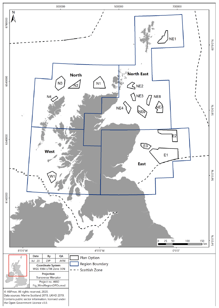
2. Plan details and purpose (including geographic scope)
2.1 Plan purpose and geographic scope
2.1.1 The Plan aims to identify the most sustainable plan options for the future development of commercial-scale offshore wind energy in Scottish waters, including deep water wind technologies, in line with the vision below:
Figure 3 Sectoral Marine Plan for Offshore Wind Energy - Plan Vision (2020)
This Plan seeks to contribute to the achievement of Scottish and UK energy and climate change policy objectives and targets, through the provision of a spatial strategy to inform the seabed leasing process for commercial offshore wind energy in Scottish waters, which;
- Minimises the potential adverse effects on other marine users, economic sectors and the environment resulting from further commercial-scale offshore wind development; and
- Maximises opportunities for economic development, investment and employment in Scotland, by identifying new opportunities for commercial-scale offshore wind development, including deeper water wind technologies.
This Plan has been developed to ensure consistency with the objectives and principles set out within Scotland's National Marine Plan (2015) and the UK Marine Policy Statement (2011).
2.1.2 The geographic scope of the Plan covers Scottish Waters (0-200 nautical miles (nm)), including Scottish Territorial Waters (0-12 nm) and the Scottish Marine Area (12-200 nm) (which is executively devolved to Scottish Ministers under the Marine and Coastal Access Act 2009).
2.1.3 For the purposes of the Plan, "commercial-scale development" is defined as projects capable of generating more than 100 MW of electricity. Projects which generate less than 100 MW of electricity are considered to be test and demonstration (or pre-commercial) and therefore are not included within the scope of this Plan.
2.1.4 The final Plan provides the spatial framework for the first cycle of seabed leasing by CES (the 'ScotWind' leasing round). Only the areas of seabed contained within the POs identified within the final Plan can be made available for lease for commercial-scale offshore wind development. The final Plan identifies a total of 15 Plan Options, located within four geographic regions (North (4), West (1), East (3) and North East (7) - as shown in Figure 1.).
2.1.5 No POs overlap with any European or Ramsar sites, although a number of Plan Options are located immediately adjacent to designated site(s), including:
| Plan Option | Designated Site(s) | Qualifying features |
|---|---|---|
| W1 | Inner Hebrides and the Minches SAC; Gruinart Flats, Islay SPA | Harbour porpoise; includes Chough, Greenland barnacle goose, Canadian light bellied brent goose |
| N2 | Solan Bank SAC | Reefs |
| NE1 | Pobie Bank SAC | Reefs |
2.1.6 It is considered, however, that the risks associated within these POs located directly adjacent to these SACs and SPAs can be best managed at a project-level, once further detail regarding the proposal is available. Further, whilst there is no direct overlap, there is potential for qualifying habitats and species from SPAs and SACs to be present within the PO areas and, therefore, may be subject to LSE from development activity. Developments located close to designated sites, therefore, may require additional mitigation measures (with associated cost, assessment and timing implications) when compared to those developments located further from designated sites (due to the increased likelihood of impacts). Although, it should be noted that mobile species (such as marine mammals and seabirds) may be present within PO areas from both nearby and distant designated sites.
2.1.7 It is recognised that cable routing and landfall activities associated with development within POs could overlap with designated sites. Due to the significant uncertainties surrounding potential cable routes to shore, these have been excluded from the scope of the Plan and Sustainability Appraisal ("SA"). The Strategic Environmental Assessment ("SEA") and Regional Locational Guidance ("RLG") highlight areas of sensitivity associated with the Plan, but these impacts are not considered within this AA in detail.
2.2 Key issues and technology types
2.2.1 For plan-level assessments, it is recognised that there is often limited information on the precise location and scale of development, or about the relevant construction methods and associated activities. Whilst 15 Plan Options have been selected and their locations are indicated, no project-level details are currently available.
2.2.2 The HRA report outlines the potential for floating offshore wind technologies to be deployed, to allow exploitation of deep-water sites. The Plan, however, does not direct which types of technology should be deployed within each Plan Option and these details will only be available at a project-level. These uncertainties have been duly recognised throughout all assessment stages.
2.2.3 The assessment has, therefore, taken account of the likely range of development options and activities (based on previous wind energy projects) and the potential worst case scenario(s) for each impact pathway and species. The Plan has a broad spatial scope and long-term temporal component, which will influence the range of potential impacts. The temporal aspects and scale of impacts will be influenced by the technological advances that will occur over the coming years. These will influence the scale of potential impacts, as well as the distances offshore that developments can be undertaken, whilst remaining commercially-viable. It will also influence the needs for future upgrading of wind generating technologies in established areas.
2.2.4 The assessment presented in the HRA Report, therefore, has not made specific assumptions about the project-level activities (e.g. device type and generating capacity). The full range of potential impacts have been incorporated in the assessment envelope (in line with the precautionary approach). The potential envelope of change has therefore been determined to identify the potential effects on features. On this basis, screening matrices and maps were produced in the Phase 3 report for the DPOs, which identified where features within individual European/Ramsar sites are at risk of LSE (or where the risk LSE could not be excluded). The Phase 3 report builds on the screening process, by considering the particular environmental pressures/changes that give rise to these risks and then provides a generic assessment of the impacts (having regard to the typical conservation objectives).
2.3 Maximum realistic development scenarios
2.3.1 The Plan provides flexibility over the exact location, nature and scale of the proposal to enable adverse effects on site integrity to be avoided at a project-level. In order to avoid significant adverse environmental effects, the Strategic Environmental Assessment identified, under this iteration of the Plan, development should be limited to 10 GW nationally. The SA has used 'realistic deployment scenarios' to assess the potential positive and negative impacts of DPOs. These 'realistic development scenarios' equated to a proportion of the overall area of the DPO (which varies according to the size and conditions of the DPO and have been derived from known constraints on development, early indications as to developer interest and established infrastructure to support development).
2.3.2 Whilst 10 GW was used as a total maximum realistic development scenario for the Plan as a whole (nationally), the individual PO scenarios (shown in Table 3) should not be taken as being an endorsement of projects up to this size within a PO, as further project level assessment and planning will be required to ensure avoidance of significant adverse effects. The use of maximum realistic development scenarios within each PO provides sufficient flexibility regarding the exact location, scale and nature of the proposal to enable potential AEOSI to be avoided (i.e. further spatial planning within POs to avoid sensitive areas).
2.4 Iterative plan review and management
2.4.1 Once adopted, the Plan will be subject to 'iterative plan review' and management, to ensure that;
- The Plan and the underpinning assessments are informed by the best available and most up-to-date scientific research and understanding, including outputs of project-level assessments and monitoring;
- The Plan accurately reflects spatial/regional context (i.e. level of construction, operational, and other activity within the region) and potential transboundary impacts; and
- The Plan reflects the prevailing market conditions, technological advancements and regulatory environment (including connections to the national grid and coastal infrastructure).
Section 11.5 of the HRA Report provides an outline of the proposed iterative plan review cycle (for the first 2 years of the Plan's lifespan). To support the iterative review process, a Programme Board and Technical Advisory Group will be established upon adoption of the final Plan, to consider the implications of emerging research, evidence and assessment methodologies. In addition, an Ornithology Working Group will be established, to specifically consider ornithology evidence gaps identified during the planning process.
2.4.2 The iterative plan review process will be informed by the best available scientific information, project-level assessment and post-consent monitoring (for consented and operational wind farm projects). As monitoring data is collected, it will be used to validate the conclusions of project-level assessment and the Sustainability Appraisal. The iterative plan review process will also consider the level of current and planned activity within the POs, regionally and nationally and potential transboundary impacts.
2.4.3 In addition, it is anticipated that the Plan will be initially reviewed after two years, to consider emerging monitoring and research evidence, the wider policy, market and regulatory context and if required, to provide an updated spatial framework for any future CES leasing round. The formal review process will commence two years after adoption of the Plan, unless Scottish Ministers seek to commence the review process earlier than Year 2. In the event that significant changes are required to the Plan, further assessment and/or consultation may be required and further details regarding this process will be confirmed at the appropriate juncture.
2.4.4 Each iteration of the Plan will be informed by any new and relevant information and research regarding the environmental, economic and social impacts of offshore wind and the effectiveness of any mitigation measures. Final decision making power regarding the Plan and any revisions will continue to rest with Scottish Ministers.
2.5 Plan governance structure
2.5.1 In order to facilitate the implementation of the Plan and iterative plan review process, a formal governance structure is required to be put in place, as outlined below in Table 2. The groupings outlined below will be formed upon adoption of the Plan and have specific functions in relation to the Plan-level mitigation measures outlined in this AA and the HRA Report.
Table 2 Plan governance structure
Group: Scottish Ministers
Role/Function:
- Responsible for approving and adopting the SMP
- Responsible for approving amendments/updates to the SMP
- Responsible for granting/refusing consent/licenses for individual offshore wind projects
- The final decision making power rests with Scottish Ministers.
Group: Sectoral Planning Programme Board
Role/Function:
- Comprised of key officials from relevant policy areas across Scottish Government, as well as representatives from Marine Planning and Policy, Marine Scotland ("MPP").
- Considers advice and evidence received from Technical Advisory Group, Ornithology Working Group and Sectoral Evidence Group.
- Provides recommendations to Scottish Ministers regarding the need to revise or update the Plan (iterative plan review process), including the need and scope of further assessment. This will be on the basis of the evidence submitted to it, which may justify the need to revise or update the Plan.
- External advice may be sought as appropriate.
- Chair: Deputy Director, Marine Scotland
- Secretariat: MPP
- The group will meet at least once per annum, or more frequently if circumstances require.
Group:Technical Advisory Group
Role/Function:
- Comprised of representatives from the statutory consultation bodies - NatureScot, the Joint Nature Conservation Committee ("JNCC"), Historic Environment Scotland ("HES") and the Scottish Environment Protection Agency ("SEPA").
- In addition, representatives from Marine Scotland Science ("MSS") and MPP will be formal members of the Advisory Group.
- Chair: Head of Planning, Development and Crown Estate Strategy Unit, MPP
- Secretariat: MPP
- Meets on at least an annual basis to consider Plan-level issues.
- Provides advice and report to the Programme Board regarding continued application of plan-level mitigation measures, the need for revisions to the Plan (as adopted) and further research/evidence/guidance requirements.
- This advice will be informed by consideration of the evidence provided during by the Sectoral Evidence Group and other stakeholders, consideration of other policy, legislative and regulatory changes which have occurred over the time period, outputs of project-level assessment and other research programmes and the spatial context (i.e. development which takes place after adoption of the SMP).
- The evidence submitted and considered may likely pertain to fields outside the expertise of members of the Advisory Group (e.g. fisheries). In such cases, the Technical Advisory Group (and Programme Board) will be required to seek further advice and representation from the relevant stakeholders (i.e. from the Sectoral Evidence Group). These views will support the formulation of advice and production of the Report.
- The decision has been taken to restrict membership of this group to the statutory consultees (as defined by the Environmental Assessment (Scotland) Act 2005), with the addition of JNCC given geographic coverage of the Plan. Other stakeholders will have the opportunity to provide input via the Sectoral Evidence Group and as above if issues pertaining to their area of interest arise.
Group: Sectoral Evidence Group
Role/Function:
- Formed of a wide range of sectoral interests (i.e. drawn from the current Steering Groups formed to support the planning process), i.e. commercial fisheries, commercial shipping and navigation, renewables industry.
- Membership shall be as follows; Crown Estate Scotland; Highlands and Islands Enterprise; Marine Scotland Science; Regional Inshore Fisheries Groups; RSPB Scotland; Scottish Enterprise; Scottish Fishermen's Federation; Scottish Government; Scottish Renewables; UK Chamber of Shipping; and WWF Scotland.
- The exact operation of this group will be confirmed following adoption of the Plan.
- This grouping will be asked to provide evidence/representations to support the iterative plan review process or may be asked to provide further representations/evidence to the Programme Board and/or Technical Advisory Board on specific issues.
- This grouping will be able to provide further evidence (relevant to the implementation of the Plan and the iterative plan review process) as it becomes available, for consideration by the Technical Advisory Group and Programme Board however, at a minimum an annual call will seek any relevant responses.
Group: Ornithology Working Group
Role/Function:
- Formed of relevant ornithology experts (drawn from the current ScotMER ornithology receptor group), i.e. NatureScot, JNCC, MSS and Scottish Environment Link ("SE Link").
- Crown Estate Scotland will also be formal members of this group.
- Chair: MPP
- Secretariat: MPP
Role in relation to application of Plan-level mitigation measures for Plan Options E1 and E2.
- To be formed immediately upon adoption of the Plan to define the scope and nature of regional surveys and research work, including assessment of survey outputs, in relation to development within Plan Options E1 and E2.
- The recommendations will be formed in consultation with relevant Option Agreement holders (or their representatives). Option Agreement holders, however, will not form part of the membership of the Ornithology Working Group.
- The Ornithology Working Group will then provide advice to the Programme Board (this is due to the replication of members on the Advisory Group with the relevant expertise and to avoid unnecessary duplication). The Programme Board will then confirm the final survey and research requirements and these details will be communicated to developers via Marine Scotland.
- Developers will be advised to complete the surveys and assessment by Marine Scotland, prior to the submission of any licence/consent application.
- Survey and assessment outputs should be provided by developers to the Ornithology Working Group, prior to the submission of any licence and consent applications, in the format directed by Marine Scotland, to support the iterative plan review process and further planning and licensing/consenting decision-making processes.
Wider role - iterative plan review process, application of plan-level mitigation measures (i.e. E3, NE2-NE4 and NE6), defining research requirements
- To assist in identifying and addressing evidence gaps (relating to ornithology) that constrain potential development within the Plan Options and are required to be addressed to inform future planning exercises.
- The Working Group will provide guidance in the production of an 'Ornithology Roadmap', which will be prepared by a contractor(s) (appointment process currently underway). The Roadmap will identify ongoing research and any specific actions required to produce the evidence base for assessing ornithological constraints.
- Upon completion of the Roadmap, the Working Group will work with the appointed contractor(s) to support the production of a 'Programme of Works' - a detailed programme of works to address strategic research projects that can be implemented within the short to medium term to initiate Roadmap actions.
- The Working Group will also be asked to;
- Provide views regarding the continued application of plan-level mitigation measures in relation to Plan Options E1-E3, NE2-NE4 and NE6;
- To provide advice/views regarding whether further research or guidance is required to inform planning and consenting; and
- Consider the findings of future project-level assessments, relevant research programmes and the wider spatial context and provide advice regarding the potential implications of these changes for the Plan (as adopted).
2.5.2 The process for continued submission of new evidence (which the draft Plan and SA referred to as the Annual Forum) is a key mechanism to support the Plan implementation and iterative review processes. Key stakeholder representatives, who form part of the Sectoral Evidence Group, will be asked to provide details of emerging evidence and research, which could have a bearing on the implementation of the Plan and resultant development on at least an annual basis, but will have the opportunity to provide this evidence as it emerged.
2.5.3 The evidence submitted may have arisen as a result of technological advances, scientific evidence, project survey and monitoring (including of the effectiveness of mitigation measures) and or as the result of project-level assessments. The request for new evidence, to support iterative plan review, should not be an opportunity for further public consultation on the Plan. Should sufficient evidence be presented, which Scottish Ministers consider justifies the need to review the Plan, then public consultation will occur at the appropriate stage in the planning process. It is currently anticipated that the Plan will be reviewed at Year 2 (although this may occur earlier if sufficient justification is provided).
2.5.4 The scope of evidence submitted will be restricted to ensure it is only relevant to the Plan and its implementation. Discussions within the Sectoral Evidence Group could follow a similar approach to that taken recently regarding consideration and discussion of emerging assessment methodologies for projects in the Forth and Tay region (2020). Further details regarding this process will be provided in due course.
2.5.5 The first annual request for evidence from the Sectoral Evidence Group and other stakeholders will be undertaken one year after the adoption of the Plan. The exact process and functioning of the Sectoral Evidence Group will be confirmed after the adoption of this Plan. The Technical Advisory Group shall provide the Report of findings to the Programme Board.
2.5.6 Members of the two Steering Groups formed to support the planning process would be approached to provide relevant evidence. The Steering Group members were as follows:-
- Crown Estate Scotland;
- Highlands and Islands Enterprise;
- Historic Environment Scotland;
- Joint Nature Conservation Committee;
- Marine Scotland Science;
- NatureScot;
- Regional Inshore Fisheries Groups;
- RSPB Scotland;
- Scottish Enterprise;
- Scottish Environment Protection Agency;
- Scottish Fishermen's Federation;
- Scottish Government;
- Scottish Renewables;
- UK Chamber of Shipping; and
- WWF Scotland.
2.5.7 In addition, the chairs of the ScotMER Receptor-Specific groups and Regional Marine Planning Partnerships, as well as Local Authorities, will be approached to provide any relevant evidence or advice. Invitations to provide evidence will also be made to other representative groups which may have an interest in the implementation of the Plan, such as Fisheries Management Scotland.
2.5.8 Evidence submitted will be considered by the Technical Advisory Group for its relevance and appropriateness. A summary of all evidence provided (as it may likely pertain to fields outside the expertise of members of the Technical Advisory Group) will be summarised and presented to the Programme Board by officials.
2.5.9 The Programme Board will then use this information to provide recommendations to Ministers regarding whether there is the need to review the Plan at this juncture (e.g. earlier than the planned review at Year 2) or whether the Plan remains reflective of current scientific understanding and knowledge. This report will be published online.
2.5.10 The Programme Board and Technical Advisory Group will also consider evidence submitted in light of other policy, legislative and regulatory changes which have occurred over the time period and the spatial context. Further, we anticipate that we will have an improved understanding of transmission and grid connection issues, as individual projects progress through the pipeline, which may have a bearing on the Plan.
2.6 Addressing research gaps
2.6.1 The planning process and HRA Report have identified potential gaps in knowledge and data, which may need to be addressed at a Plan and/or project-level. The Technical Advisory Group and Ornithology Working Group, as outlined above, will consider these data and knowledge gaps in further detail over the coming years to support future planning exercises.
2.6.2 A number of strategic research programmes already exist and are undertaking work to address these gaps. Further, project-level assessment and monitoring may provide data and evidence which can address these gaps. As this evidence becomes available, it is anticipated that it will inform future plan and project-level assessment accordingly. Particularly, for example, in relation to emerging technology and installation methods (i.e. floating offshore wind technologies) and post-consent monitoring regarding seabird behaviour/interactions with wind turbine generators ("WTG").
2.6.3 Consideration of the potential impacts on seabird qualifying interests has identified a number of evidence gaps, which are currently being considered by the Scottish Marine Energy Research ("ScotMER") programme, including;
- Collision mortality and avoidance behaviour of Black-legged Kittiwake, Northern Gannet and Great Black-backed Gull (OR. 17). All three species concerned are of direct relevance to future offshore wind farm development in the Moray Firth region, whilst in the Forth and Tay region Kittiwake and Gannet are the key species of concern in relation to potential collision mortality.
- The consequences of displacement and barrier effects on survival and productivity (OR. 23), and subsequently populations of Atlantic Puffin, Razorbill and Common Guillemot are key constraints in the Forth and Tay region, and to a lesser extent in the Moray Firth region.
- The drivers of any observed changes in distribution and abundance of Black-legged Kittiwake, Northern Gannet, Atlantic Puffin, Razorbill, and Common Guillemot in and around offshore wind farms (OR. 06, OR. 19, OR. 20, OR. 21).
- The movements of adult birds during the non-breeding season and immature birds during the entire year, and their level of exposure to cumulative effects (OR. 02, OR. 03, OR. 09).
2.6.4 Addressing these evidence gaps will support future project and plan-level decision making and assessment process.
2.6.5 The Post Adoption Statement (2020) sets out in further detail the research and evidence gaps which need to be addressed, including planned research work to be undertaken in the coming years. The requirement, for example, for regional-level survey and assessment work to be undertaken for POs E1 and E2 (a mitigation measure outlined at section 4 of this AA) seeks to address uncertainty regarding the presence, distribution and abundance of seabirds during the non-breeding season in this region, as well as connectivity with key seabird colonies on the East and North East coast.
2.7 Project-level mitigation measures considered
2.7.1 Details of mitigation measures deployed for individual wind farm projects have been collated to produce a central 'project-level mitigations options' table (Table J1, Appendix J)[1] - which have been measured against the impacts matrix included within Table J2, to cross-reference potential mitigation measures to impacts. These mitigation measures have been derived from previous strategic assessments and project-level assessments and provide a comprehensive overview. One of these measures is, during the early stages of any development, 'a primary consideration will be to try to avoid habitats within a European/Ramsar site and minimise exposure and risk'.
2.7.2 Further relevant project-level mitigation measures identified in Appendix J include (but are not limited to);
- Identification of the most appropriate mechanism for disposal of excavated sediment to avoid adverse impacts on designated intertidal/coastal habitat features from smothering;
- Use of cable and device installation methods that minimise sediment re-suspension (impacts on fish and shellfish from increased suspended sediment and turbidity);
- Survey design to mitigation/avoid visual disturbance from vessels or shoreline activity; and
- Use of methods and/or timing to reduce noise from geophysical survey, borehole work, seismic survey and use of standard measures to avoid/mitigate effects on designated habitats and species (impacts of noise on marine mammal qualifying interests).
2.7.3 Whilst this list demonstrates a range of potential project-level mitigation measures which could be deployed, the list does not provide further certainty that European/Ramsar sites will not be affected. The application of these measures is not a formal requirement of the Plan, however, they provide useful context for the HRA Report and can inform further project-level assessment and discussion as development progresses (as appropriate to the project location and impacts).
| Region | DPO | Total DPO Area (km²) | Realistic maximum development scenario for DPO (GW) | Realistic development as percentage of total DPO Area | Regional Low Scenario (GW) | Regional Medium Scenario (GW) | Regional High Scenario (GW) |
|---|---|---|---|---|---|---|---|
| East | E1 | 3742 | 3 | 16% | |||
| E2 | 1287 | 2 | 31% | ||||
| E3 | 474 | 1 | 42% | ||||
| Sub-total | 5505 | 6 | 1 | 2 | 3 | ||
| North East | NE1 | 751 | 2 | 53% | |||
| NE2 | 345 | 1 | 58% | ||||
| NE3 | 265 | 1 | 76% | ||||
| NE4 | 440 | 1 | 45% | ||||
| NE6 | 699 | 2 | 57% | ||||
| NE7 | 684 | 3 | 88% | ||||
| NE8 | 339 | 1 | 59% | ||||
| Sub-total | 3522 | 11 | 1.5 | 3 | 4.5 | ||
| North | N1 | 1163 | 2 | 34% | |||
| N2 | 561 | 2 | 71% | ||||
| N3 | 1106 | 2 | 36% | ||||
| N4 | 200 | 1 | 100% | ||||
| Sub-total | 3030 | 7 | 1 | 2 | 3 | ||
| West | W1 | 754 | 2 | 53% | |||
| Sub-total | 754 | 2 | 0.5 | 1 | 2 | ||
| Total: | 14646 | 26 | 4.3 | 8.6 | 13.5 | ||
| Scaled back to national scenarios (GW): | 3 | 5 | 10 | ||||