Sectoral marine plan: appropriate assessment
Assessment of the implications of the sectoral marine plan for offshore wind energy for designated special areas of conservation special protection areas, candidate special areas of conservation and proposed special protection areas in view of the sites' conservation objectives.
16. Mitigation measures
16.1.1 Key mitigation measures have been implemented to provide the necessary assurances that the Plan will not have an adverse effect on any European site or European marine site, either alone or in-combination with other plans and projects. These mitigation measures are outlined in the Plan document itself and have been identified via the Habitats Regulations Appraisal. The mitigation measures are set out below.
16.2 Monitoring and review
16.2.1 The iterative plan review ("IPR") process will involve a phased and iterative approach to plan-implementation which is linked to ongoing project developments and their associated post-consent monitoring work, with the findings from such project-level work feeding back into the next phases of Plan implementation.
16.2.2 This is required so that results from post consent monitoring for consented projects and ongoing research programmes (such as ScotMER) can be fed into subsequent developments, in order for lessons learnt to be shared and evidence gaps filled, thus reducing potential impacts to these sites. Further detail regarding monitoring and review is provided in the Post Adoption Statement (2020).
16.3 Project-level HRA
16.3.1 Individual applications for marine licence and/or s.36 consent for commercial-scale offshore wind development within the POs will be required to under the HRA process prior to the grant of any consent/licence, in accordance with the Habitats Regulations. Project-level HRA must be informed by the current best available scientific knowledge and understanding. In addition, developers should note that the screening process for project-level HRA may identify sites or features which have been screened out of the HRA Report for the Plan.
16.3.2 This project-level HRA will be informed by the information contained in the HRA Report and this AA. Project-level HRA will identify more precisely the nature, scale, duration and location of the proposed development, and thus its potential effects, than is possible at a Plan-level.
16.3.3 Project-level HRA should take into consideration the mitigation measures outlined in the HRA Report, but may identify additional/alternative mitigation measures, dependent on the nature of the predicted impacts of the individual project. The final decision on the need for, and sufficiency of project-level specific measures, will be undertaken at a project-level and will be a matter for the consenting body to determine.
16.3.4 Information that will need to be provided in project-level HRAs will include (but not be limited to);
- Updates on the location and status of new European/Ramsar designations;
- New information on interest feature sensitivities, distributions, abundance and connectivity (in the context of latest scientific understanding) (baseline conditions);
- Assessment of effects during all phases of the works (survey, construction, operation, maintenance and decommissioning), including in-combination effects with other plans and projects; and
- Proposed mitigation measures.
16.3.5 The outputs of project-level HRA will be used to inform the iterative plan review process.
16.4 Maximum realistic development scenarios
16.4.1 Development within individual Plan Options shall not exceed the 'maximum realistic development scenario' for that Plan Option, set out in the Plan (see Table 3 above). The use of maximum realistic development scenarios within the overall boundary of the PO provides flexibility over the exact location, nature and scale of the proposal to enable adverse effects on site integrity to be avoided at a project-level.
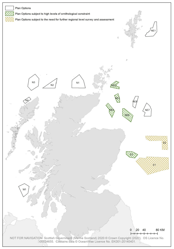
16.5 Plan Options subject to high-levels of ornithological constraint
16.5.1 Plan Options E3, NE2, NE3, NE4 and NE6 (as shown in green in Figure 8) are subject to Plan-level mitigation and are deemed as being 'subject to high levels of ornithological constraint'. Development within these Plan Options can only progress where sufficient scientific evidence can be provided to reduce the risk to an acceptable level (unless it can be determined that there are imperative reasons of overriding public interest that require development to proceed). This scientific evidence would thereby facilitate either;
a) Revision to the Plan (via the iterative plan review process) which removes the application of this mitigation measure at a Plan level; or
b) The granting of a licence or consent for the project, where it can be concluded by the competent authority that there would be no adverse effect on the integrity of any European site(s) or European marine site(s).
16.5.2 The HRA Report provides an outline of the research gaps/uncertainties at section 11.6. The Ornithology Working Group will establish the research and evidence gaps and work required to address said gaps following the adoption of the Plan.
16.6 Plan Options subject to the need for further regional level survey and assessment
16.6.1 Plan Options E1 and E2 (as shown in orange in Figure 8) are subject to the need for the completion of further regional level survey, research and assessment work. This regional survey work should cover the region(s) which will be likely impacted by the development and should not solely be limited to the Plan Option area or the offshore region in which the Plan Option is located. This regional level survey, research and assessment work is required to address:
- Uncertainty regarding the potential scale of cumulative impacts in this region on seabird species (resulting from collision, displacement and barrier effects); and
- A lack of information regarding seabird densities and behaviours in the offshore region during the non-breeding season.
16.6.2 Any developers which secure Option Agreements for Plan Options E1 and/or E2 should discuss and establish the parameters of the required survey work and the assessment of survey outputs with the Ornithology Working Group prior to commencing any such works. Marine Scotland will then provide direction as to the scope and format of the survey, research and assessment work and how the outputs should be provided.
16.6.3 This regional level survey and assessment activity could incorporate, for example, an initial study to identify foraging areas for key seabird species SPA populations and at-sea densities. This study could then be supplemented by regional level survey effort, which could incorporate elements such as aerial surveys or possibly seabird tagging work at key colonies.