Sectoral marine plan: appropriate assessment
Assessment of the implications of the sectoral marine plan for offshore wind energy for designated special areas of conservation special protection areas, candidate special areas of conservation and proposed special protection areas in view of the sites' conservation objectives.
Appendix Five: Draft Offshore Wind Plan Technical Note: Updated Bird Foraging Ranges (March 2020)
Suggested Citation
ABPmer,(2020). Draft Offshore Wind Plan,Technical Note: Updated Bird Foraging Ranges, ABPmer Report No. R.3379/TN. A report produced by ABPmer for Marine Scotland March 2020
Notice
ABP Marine Environmental Research Ltd ("ABPmer") has prepared this document in accordance with the client's instructions, for the client's sole purpose and use. No third party may rely upon this document without the prior and express written agreement of ABPmer. ABPmer does not accept liability to any person other than the client. If the client discloses this document to a third party, it shall make them aware that ABPmer shall not be liable to them in relation to this document. The client shall indemnify ABPmer in the event that ABPmer suffers any loss or damage as a result of the client's failure to comply with this requirement.
Sections of this document may rely on information supplied by or drawn from third party sources. Unless otherwise expressly stated in this document, ABPmer has not independently checked or verified such information. ABPmer does not accept liability for any loss or damage suffered by any person, including the client, as a result of any error or inaccuracy in any third party information or for any conclusions drawn by ABPmer which are based on such information.
All content in this document should be considered provisional and should not be relied upon until a final version marked 'issued for client use' is issued.
All images on front cover copyright ABPmer apart from seahorse (A J Pearson).
ABPmer Quayside Suite, Medina Chambers,Town Quay,Southampton,Hampshire 5014 2AQ T: +44 (0) 2380 711844 W: http://www.abpmer.co.uk/
1 Introduction
This note has been prepared following the recent release of an update to the seabird foraging ranges historically used in HRA screening of offshore wind projects.
The historic data, a synthesis of available tracking studies was published by Thaxter et al. in 2012. These data,principally focussed on mean maximum foraging ranges, have subsequently been referred to across multiple project and plan level HRA to support screening of Special Protection Areas (SPA) for bird species receptors.
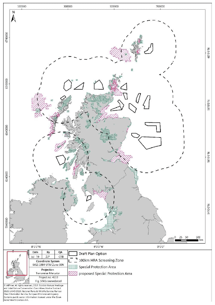
Within the HRA produced for the Scottish Sectoral Marine Plan for Offshore Wind, pre-screening of SPA sites was based on a 100 km buffer, therefore capturing all sites within the buffer irrespective of the foraging ranges of the designated species (Figure 1). However, there are a number of seabird species that forage over greater distances, beyond the 100 km pre-screening buffer. Based on the Thaxter et al (2012) mean maximum foraging ranges, the species included were:
- Atlantic Puffin (1OS km)
- Lesser Black-backed Gull (141 km)
- Manx Shearwater (330 km)
- Northern Fulmar (400 km)
- Northern Gannet (229 km)
Thus, the mean maximum foraging ranges of these species (according to Thaxter et al., 2012) were used to screen in additional SPA and Ramsar sites beyond the 100 km pre-screening buffer.
During the HRA, these foraging ranges were then referred to, supporting assessment of likely impact for bird species in addition to species or location specific spatial evidence such as the RSPB seabird utilisation study (Cleasby et al., 2018).
An updated synthesis of seabird tracking studies was released in early 2020 which incorporates both the studies considered in the Thaxter et al paper, and those undertaken from 2012 to 2019 (Woodward et al, 2019). The Woodward et al (2019) study has resulted in a number of changes to the
foraging ranges of seabirds, including the provision of a range where none had previously been presented. These revisions are of note to those seabird species considered particularly sensitive to the potential impacts from offshore windfarms.
Upon review of the updated data we have identified significant increases in mean maximum foraging ranges for Black-legged kittiwake, Razorbill, Great skua and Great black backed gull (Table 1) which warrant further consideration and discussion, contained herein.
| Species | Thaxter et al., 2012 | Woodward et al.,2019 |
|---|---|---|
| Black-legged kittiwake | 60 ± 23.3 km | 156.1 ± 144.S km |
| Razorbill | 48.S ± 35.0 km | 88.7 ± 75.9 km |
| Great skua | 86.4 km | 443.3 ± 487.9 km |
| Great black backed gull | N/A | 73 km |
Source: Woodward et al., 2019
2 Black-legged kittiwake
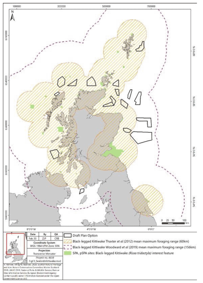
- Black-legged kittiwake are of particular concern when considering the impact of offshore wind farms due to the currently observed declines in populations, particularly on the east coast of the UK. As a result, for DPO areas (NE2, NE3, NE4, NE5, NE6 and E3) within the Thaxter et al, (2012) foraging range (60 km) on the east coast, 'temporal mitigation' was proposed within the HRA, to postpone any development until such a time that sufficient data around likely collision risk and kittiwake distribution is available to support a conclusion of no adverse effect.
- The increase in foraging range from 60 km to 156 km increases the number of DPO which fall within the buffered SPA foraging ranges, and therefore the question may be raised as to whether it is appropriate to incorporate these additional DPO areas into the 'temporal mitigation'. Figure 2 shows all SPA with Kittiwake as an interest feature buffered out to both the 60 km and 156 km ranges, showing that four DPO areas off the east coast of Scotland which were previously outwith the foraging ranges, are now wholly within the extended buffer (i.e. NE7, NE8, E1 and E2.)
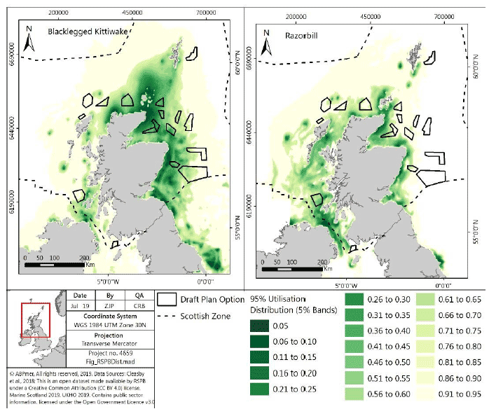
- However, based on the consideration of other spatial data, as reported in Cleasby et al (2018) it is our view that these sites should not be included in the temporal mitigation policy. These hotspot maps, based on utilisation distribution reported in Wakefield et al. (2017) (Figure 4), show that whilst there is potential for some usage by Black-legged kittiwake within these additional DPO areas, it is considerably lower density than the other north east and east DPO sites, and therefore grouping all east coast sites into the same mitigation measures would not be considered proportionate.
- It should be recognised, however, that at a project level, these increased foraging ranges will be used for HRA screening. This will likely result in additional SPA/Ramsar being screened to those during the plan level HRA, For example, offshore windfarm proposals in E2 will screen in the Firth of Forth SPA
- Overall, for Black-legged kittiwake, whilst the increase in foraging range has the potential to impact on sections of the HRA methodology, the conclusions of the HRA are considered to remain valid.
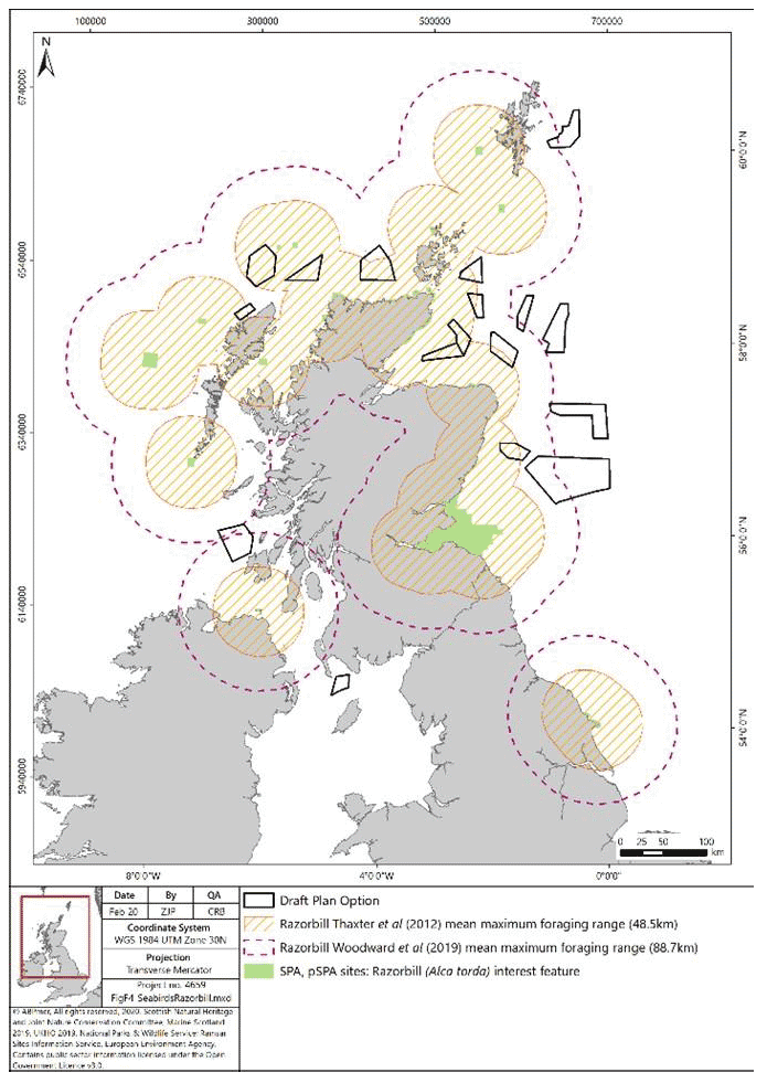
3 Razorbill
Similar to Black-legged kittiwake, Razorbill was considered to be a higher risk species from offshore windfarms during assessment for the purposes of HRA, although, this risk is primarily due to displacement rather than collision risk as synthesised within the HRA for the Sectoral Marine Plan for Offshore Wind. The increase in mean maximum foraging range from 48.5 km to 88.7 km would lead to greater overlap with DPO areas (Figure 3). However, whilst this may influence minor changes in the assessment of risk to Razorbill, the screening process will not be impacted, as all sites within 100 km were already screened in.
In addition, from the use of spatial distribution data for Razorbill, as presented in Cleasby et al (2020) and Wakefield et al (2017), it is clear that for Razorbill (Figure 4), areas of concern are generally restricted to coastal areas of shallower water. Consequently, the conclusions of the HRA remain valid.
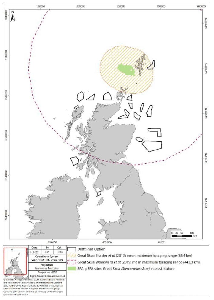
4 Great skua
There is a single proposed SPA (pSPA) in Scotland, for which Great skua are a designated feature (Seas off Foula pSPA). This site was previously screened in, based on proximity to site NE1 (Figure 5). The increased foraging range will lead to an overlap with all DPO areas except SW1 and W1.
Great skua is generally considered of lower risk from offshore wind development compared to other species such as Black-legged kittiwake (Furness et al. 2013). Therefore, whilst the extended foraging range covers a significantly greater area with more overlap with DPOs the increase in risk from offshore wind development is uncertain. In addition, the significant area covered by the foraging range indicates that whilst there may be potential for usage throughout the range, the spatial distribution of Great skua throughout this area is uncertain, with data collected by Pollock et al (2000) indicating that areas of highest usage is more likely to be in areas within the initial foraging range of 80 km with lower usage towards the edges of the updated range.
Therefore, whilst there is potential for minor changes to the assessment process for Great Skua, the conclusions of the HRA are considered to remain valid.
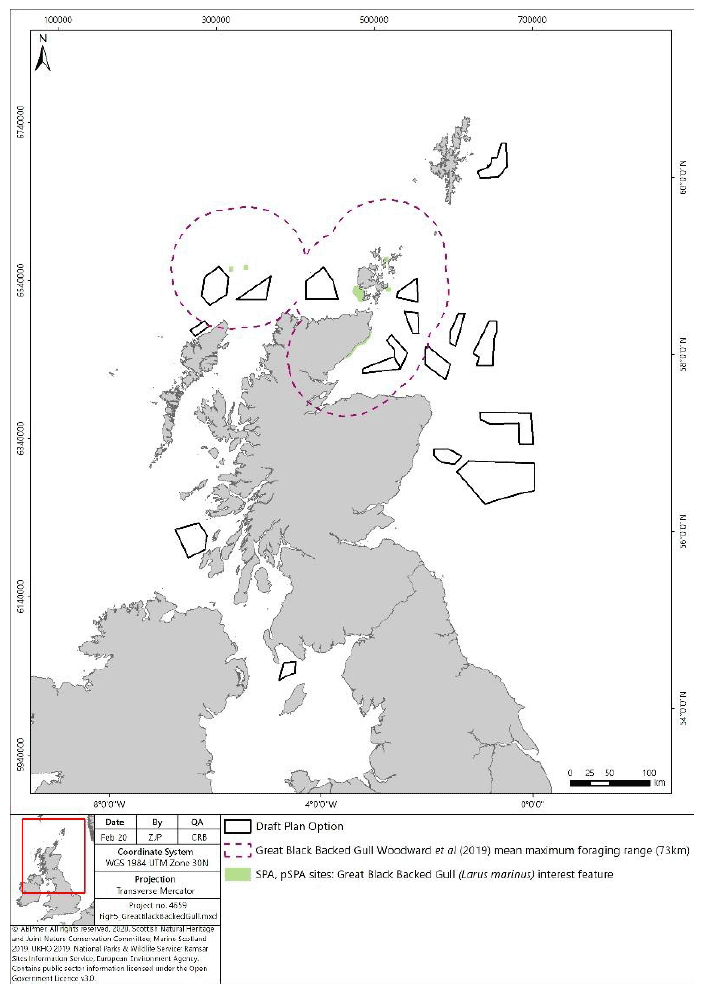
5 Great black-backed gull
Great black-backed gull did not previously have a published foraging range based on tracking study evidence. Therefore, all sites within 100 km were screened in and, as a result the new foraging range of 73 km would not impact this step.
Large gull species are generally considered to be of higher risk to collision with offshore wind farms, based on the results of the ORJIP study (Skov et al, 2018).
The new foraging range, whilst giving an indication of potential overlaps between the foraging ranges from SPA and some DPOs (Figure 6), does not include any consideration of the distribution or usage density for Great black-backed gull.
The NE DPOs within the Moray Firth which overlap with the GBBG foraging range (NE2, NE3, NE4, NE5 and NE6) are already included in the mitigation proposed for kittiwake within the HRA. Hence, concerns regarding Great black-backed gull would be managed through further work required to provide additional information on bird distribution in this area to address the mitigation requirement.
However, for sites in the north, particularly N2 and N3 which are in close proximity to the North Rona and Sula Sgeir SPA and N1 in proximity to Hoy SPA, consideration will be required at a project level as to the usage of the seas by Great black-backed gull for foraging.
The conclusion of the HRA for Great black-backed gull, that work required for the purposes of project level HRA would identify areas of concern and support avoidance of significant adverse effects, will remain valid.
6 References
Cleasby, I., Owen, E., Wilson, L., Wakefield E.D., O'Connell, P.,Bolton, M. 2020. Identifying important at- sea areas for seabirds using species distribution models and hotspot mapping. Biological Conservation. Volume 241, January 2020, 108375
Pollock, C.M., Mavor, R., Weir, C.R., Reid, A., White, R.W., Tasker, M.L., Webb, A. and Reid, J.B., 2000. The distribution of seabirds and marine mammals in the Atlantic Frontier, north and west of Scotland. The distribution of seabirds and marine mammals in the Atlantic Frontier, north and west of Scotland, pp.1-92.
Thaxter, C.B., Lascelles, B., Sugar, K., Cook, A.S.C.P., Roos, S., Bolon, M., Langston, R.H.W. & Burton,
N.H.K. 2012. Seabird foraging ranges as a preliminary tool for identifying candidate Marine Protected Areas. Biological Conservation 156: 53-61.
Skov, H., Heinänen, S., Norman, T., Ward, R.M., Méndez-Roldán, S. & Ellis, I. 2018. ORJIP Bird Collision and Avoidance Study. Final report - April 2018. The Carbon Trust. United Kingdom. 247 pp.
Wakefield, E.D., Owen, E., Baer, J., Carroll, M.J., Daunt, F., Dodd, S.G., Green, J.A., Guilford, T., Mavor,
R.A., Miller, P.I., Newell, M.A., Newton, S.F., Robertson, G.S., Shoji, A., Soanes, L.M., Votier, S.C., Wanless, S., Bolton, M. 2017. Breeding density, fine-scale tracking, and large-scale modelling reveal the regional distribution of four seabird species. Ecological Applications, 27(7), 2017, pp. 2074-2091.
Woodward, I., Thaxter, C.B., Owen, E. & Cook, A.S.C.P. 2019. Desk-based revision of seabird foraging ranges used for HRA screening, Report of work carried out by the British Trust for Ornithology on behalf of NIRAS and The Crown Estate, ISBN 978-1-912642-12-0.