Scotland's Fourth Land Use Strategy: 2026-2031
Scotland’s Fourth Land Use Strategy sets out a new vision and objectives to support the development of integrated land use. The strategy covers the next five years and includes a commitment to publish a delivery plan and a refreshed set of land use principles.
4. Land use data, and monitoring and evaluation
4.1 Understanding current land use in order to understand the future
It is necessary to develop a clear and broadly agreed understanding of land at a national scale. This is vital as Scotland’s land use is place-specific; land uses in one part of the country will not be suitable in others. This is driven by the diversity of Scotland’s climates, elevation, soil condition and other factors.
By understanding the current picture we can more easily identify the discussions and ultimately the actions needed to inform the best use of Scotland’s land. Developing this understanding and providing robust data will be a key element of the delivery of the Strategy going forward and will be integral to identifying actions, and monitoring and evaluating progress.
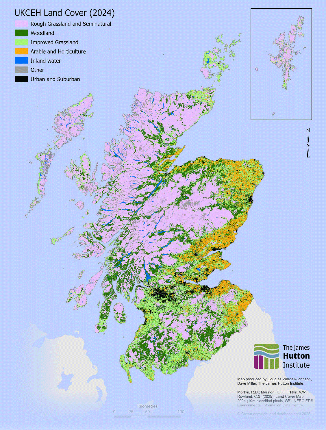
The following section sets out a preliminary, high-level understanding of our land and its use. Figure 4 (page 23) provides a summary of key land statistics and Figure 5 (page 24) shows Scotland’s land cover*, using the United Kingdom Centre for Ecology and Hydrology (UKCEH) map from 2024.
This information and more is explored in more detail in the supporting evidence pack (standalone Annex E). It is provided in response to consultation feedback from stakeholders that the Strategy must provide a clearer understanding of Scotland’s current land use now before considering how it may need to change.
The evidence pack at Annex E provides a baseline and aims to increase the understanding of the interplay between landscape, land use and ecosystem services.
It draws on published materials, including those from the Environment, Natural Resources and Agriculture (ENRA) Strategic Research Programme. Data sources including those relating to land cover, land capability, land ownership, agriculture, housing and renewable energy, to describe the current position.
How it is intended to be used
The pack is not designed to be prescriptive. It provides a transparent overview of the best available evidence to support clear, well-informed discussions and decisions about Scotland’s finite land resources. This will be key as the country responds to climate change, biodiversity loss, and the transition to a net zero, nature positive economy. In this pack maps of key datasets have been reproduced to visualise Scotland’s land opportunities.
Links to a wider range of datasets which present alternative ways of understanding similar data have also been referenced. The selected maps for inclusion focus on information already in the public domain.
Scotland’s Land Cover
*Scotland’s land cover (the mix of plants, soils, and human-made material on a piece of land) helps explain a critical dimension of Scotland’s varied land uses.
Figure 4: Key statistics (additional information available in the supporting evidence pack
Scotland is approximately 8 million hectares in size
Over 19,555 people employed within forestry and timber processing, and 25,000 FTE if including forest recreation and tourism (2019)
Our rural areas constitute 98% of landmass and 17% of its population£3.45bn in total agricultural output (2020)
We have 790 islands of which 93 are currently inhabited£1.1bn in economic contribution (Gross Value Added) of forestry and related activities in 2019
Agriculture is the dominant land use - approximately 5.16 million hectares, or 66% of the total land area29% of all modern apprenticeships starts were in mainly rural areas (2022/23)
52% of agricultural land is classified as rough grazing which helps support Scotland’s world-renowned livestock industry17% of Scotland’s population live in rural areas (930,000)
Forests and woodlands now span over 1.5 million hectares - approximately 500,000 hectares is publicly owned as part of the National Forest Estate, while over 1 million hectares are privately owned2.7% of Scotland’s land is in community ownership (2022)
Scotland is among Europe’s richest countries in peat resources with around 2 million hectares of peatland storing an estimated 1.6 billion tonnes of carbon17% of all second homes in Scotland are located on our islands
Protected Areas cover 18% of Scotland’s land area. But only 65% of natural features on protected sites are in a favourable condition50% of Scotland’s land is owned by just over 400 landowners (2014)
67,400 people within the total agricultural workforce (2024)57% of rural land in Scotland is owned by private estates
4.2 Monitoring and evaluation
To understand progress toward our long-term vision it is essential to monitor and evaluate the cumulative impacts and benefits of land use decisions and interventions.
Through our consultation we recognised that there are challenges to this including:
- inconsistent availability and quality of data across indicators and outcomes
- difficulty attributing changes directly to specific policy interventions
- complexity in defining scope, given the broad and interconnected nature of the concept
Therefore, the consultation paper set out an approach to the first steps in developing a robust monitoring and evaluation framework that can track progress. We sought to identify the indicators which:
- are used to measure the relevant objectives from other national strategies and plans
- articulate the sum of these actions
In response, we saw an almost even split in respondents in support of and opposed to the suggested approach and indicators.
We received feedback with multiple suggestions regarding the structure of the approach as well as the indicators, the possible role of qualitative as well as quantitative data and the need to reflect regional variation, land use pressures, and local priorities. More detailed information on this can be found in the corresponding section of the consultation analysis report.
In recognition of the importance and need for an effective and robust monitoring and evaluation framework we commit to the follow action.
Action Point
Through the lifecycle of this Strategy we will work with stakeholders from across the relevant land use areas to develop a Monitoring and Evaluating Framework for integrated and resilient land use, to be adopted by the publication of Scotland’s fifth Land Use Strategy at the latest.
Contact
Email: lus4@gov.scot