Scotland's Fourth Land Use Strategy: 2026-2031
Scotland’s Fourth Land Use Strategy sets out a new vision and objectives to support the development of integrated land use. The strategy covers the next five years and includes a commitment to publish a delivery plan and a refreshed set of land use principles.
3. Integrated land use
3.1 Integration across land use policies
Across Scotland’s land we see various actions supporting food production, forestry and tree planting, peatland restoration, nature restoration and protection, economic activity, housing, tourism and recreation, transport infrastructure and renewable energy generation, to name a few. These seek to achieve benefits for areas of national interest such as, food security, timber security, climate change mitigation and adaptation, biodiversity, economic development, and health and wellbeing.
This demonstrates that across any given part of Scotland there are numerous active strategies, plans and visions such as;
- Vision for Agriculture
- Sustaining Scotland: Supplying the World: A strategy for Scotland’s food and drink industry
- Scottish Biodiversity Strategy
- Peatland ACTION - 5 Year Partnership Plan
- Scotland’s Climate Change Plan – 2026-2040
- Climate change: Scottish National
- Adaptation Plan 2024-2029
- Scotland’s Forestry Strategy 2019–2029
- National Planning Framework 4
- Our Place in Time – The Historic
- Environment
- Scotland’s National Islands Plan
- Scotland’s National Marine Plan
Respondents to our consultation overwhelmingly agreed that integrated land use is the most effective approach to addressing these ambitions. They also highlighted that the relationship between government strategies, plans policies and actions is not always clear.
Without clarity they feel that those who live, manage, and rely on Scotland’s land are at a disadvantage and unable to play the full role that they can towards achieving national, regional, and local targets and ambitions.
Annex A contains a diagram which provides an understanding of the positioning of key strategies, plans and vision documents.
3.2 Drivers of Integration and collaboration
Through the development and ongoing work of this fourth Strategy we have applied systems thinking to map out the key factors that enable or hinder progress toward integrated landscapes.
This exercise revealed clusters of drivers and barriers that can help us better understand how land use might evolve toward 2045. This understanding has been further enhanced through the stakeholder responses to the consultation.
One of the most important findings from this work is how it re-emphasised the high degree of interconnectedness within the land-use system. Three key objective themes were identified (see figure 2 below):
Nature and climate
Jobs, skills and economy
Communities, place, people and equity
It is clear that land managers’ incentives to move toward integrated landscapes is a key factor which sits at the heart of this system, and this, in turn, is influenced by a range of factors.
Figure 1: Key objective themes
Nature and climate:
High-impact factors that influence integrated landscapes:
- trust in new practices
- financial and social pressures on land managers
- perception of integrated land use as a risky choice
High-impact factors that influence integrated landscapes:
- food production
- land used exclusively for food production
- uptake of technology
Jobs skills and economy:
High-impact factors that influence integrated landscapes:
- ability (financial and time) to engage with education
- land managers in education
- knowledge of land’s potential
High-impact factors that influence integrated landscapes:
- land manager’s land-based income
- debt
- uptake of funds that encourage integrated land use
Communities, place, people and equity:
High-impact factors that influence integrated landscapes:
- concern about climate change (arising from climate impacts or increased news coverage)
High-impact factors that influence integrated landscapes:
- land managers’ incentive to move to more integrated land use
- land managers’ administrative burden
- community awareness of integrated land use opportunities
Whilst we do not seek to direct land managers, we can help achieve integrated, resilient land use by promoting enabling aspects of the system in which they operate.
Understanding which factors are the most significant will help us to identify opportunities through the development of the delivery plan and corresponding workstreams.
Aligning actions across the broad range of contributing policy areas - see figure 2 below - will support the ongoing strategic evolution of Scotland’s Fourth Land Use Strategy.
The ongoing use of systems analysis can help us to take a holistic approach which is focused on the most significant factors within the land use system. Ensuring that action is directed where it has the potential to have the most impact.
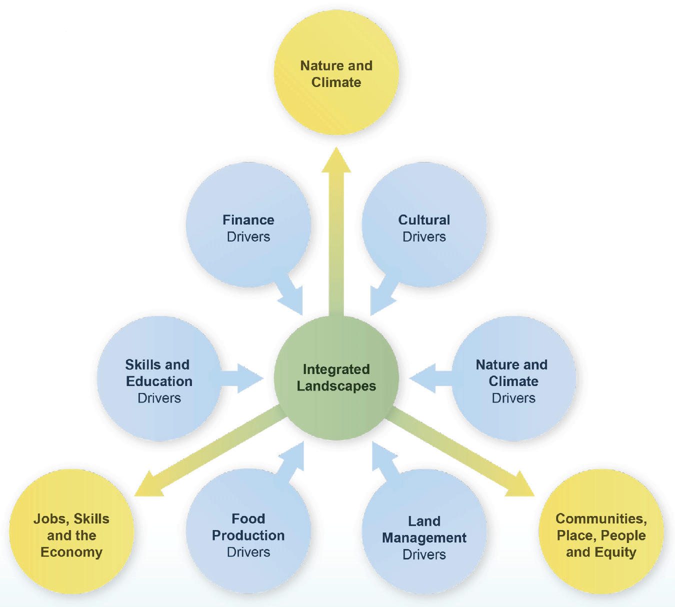
Graphic text below:
Centre circle:
- Integrated landscapes
Outer blue circles:
- Food production drivers
- Land management drivers
- Nature and climate drivers
- Cultural drivers
- Finance drivers
- Skills and education drivers
Outer yellow circles:
- Jobs, skills and the economy
- Communities, place, people and equity
- Nature and climate
3.3 Demonstrating and communicating the benefits of integration
Illustrative landscapes
Through Scotland’s Third Land Use Strategy we introduced a series of illustrative landscapes to represent different types of land in Scotland. This approach was, and continues to be, well received.
Now available at Annex B, we continue to use them as a means of demonstrating how different uses of land interact with each other and how integrated policy actions can support our drive towards an integrated and resilient national landscape.
Real world examples
Within our consultation, we asked about the role and benefit of case studies, as a means of showcasing positive actions across Scotland within the Land Use
Strategy. This was met with widespread support, and the following section provides examples of actions across three scales:
- Holding scale:
Auchlyne and Suie Estate
- Local landscape/catchment scale:
Eddleston Water Project
- Regional landscape scale:
Regional Land Use Partnerships (RLUPs)
Holding scale:
Auchlyne and Suie Estate
Often the peatlands on an estate are seen as ‘dead ground’, only being ‘productive’ for stalking or to grow livestock or wood stock. Looking at the estate businesses as a whole through integrated land management plans healthy peatlands can benefit not only the estate but the wider public.
Landowner Emma Paterson worked with the Loch Lomond and the Trossachs National Park Authority’s Land Management Team to take a more holistic view of the estate. Together they identified opportunities to improve both the financial and environmental sustainability of the business.
The use of Integrated Land Management Planning highlights the connectivity of different aspects of the estate. Benefits include:
- with more water retained within the peat there is reduced peak flow and longer flow in times of low rainfall
- the ground, with a healthier vegetated surface rather than bare peat, helps certain plant growth to happen earlier in the spring, allowing the estate to put out stock earlier, or reduce supplementary feeding
- the infilling of artificial drainage features will reduce the number of lambs and other animals lost down the drains where they are unable to escape and often not found
- re-profiled hags (ridges of eroded and dried peat) make travel across the peatlands easier and prevent tracking in the only navigable areas, thus deer management is made easier as carcasses can be more easily extracted from the site
- the improved landscape may have a benefit for tourism to the estate
The positive action of an estate to bring these habitats back into a healthy sustainable state can demonstrate how the estate fits in with the wider landscape, and its role in supporting the environment for all.
Local landscape / catchment scale:
Eddleston Water Project
This project represents a long-term study into Natural Flood Management (NFM) through landscape-scale restoration of the Eddleston catchment, as part of a sustainable approach to flood risk reduction. A partnership initiative led by Tweed Forum, the project seeks to understand how natural catchment characteristics can complement traditional flood defences, delivering both flood mitigation and ecological benefits.
Eddleston Water was historically straightened, embanked, and drained for agriculture and infrastructure, resulting in degraded habitats and frequent flooding. Classified as an EU Special Area of Conservation for species like salmon, lampreys, and otters, its ecological status was rated ‘bad’ under the EU Water Framework Directive.
The project’s core aims include:
1. Assess the effectiveness of NFM measures in reducing flood risk.
2. Evaluate ecological improvements from river restoration.
3. Collaborate with landowners and communities to balance environmental gains with viable farm businesses.
Emerging results of the project indicate that ‘lag time’ between rainfall and peak river flow has increased, flood peak in the upper catchment has reduced and new meander channels have an increased diversity of habitats (to name a few). With evidence indicating that NFM measures already in place have avoided flood damages of around £950k and wider benefits across the catchment estimated at 4 times this.
The project underscores that meaningful flood risk reduction requires catchment-wide application of diverse NFM measures, integrated with traditional defences. Beyond hydrological gains, NFM delivers substantial ecological and economic co-benefits, making it a cornerstone of sustainable land and water management.
Regional landscape scale:
Regional Land Use Partnerships
Innovation through communication: Scotland’s rural communities are at the forefront of climate change and biodiversity loss. They are made up of a rich mixture of people who often have differing relationships with the land around them. Through the work of the Northwest Highlands community-led RLUP it was recognised early that local discussion, planning and decision making would be central to achieving land use change in a manner through which communities can prosper.
In an innovative approach, they employed ‘local leads’ to drive place-based engagement, as residents of the area, representing the land ownership, land management, crofting, third sector and education sectors.
Channelling their lived experiences and knowledge of local issues, the leads identify, approach, and facilitate meaningful conversations with a number of peers. This has enabled them to successfully orchestrate collaboration between multiple estates in the region, on key issues. Several other estates have indicated a willingness to begin similar partnerships.
Partnership Integration: Recognising the potential benefits of integration, the South of Scotland RLUP identified an early opportunity to integrate the RLUP with the work of the Regional Economic Partnership (REP). This is providing a unique opportunity for greater understanding of the relationship between regional land use and wider regional businesses and livelihoods.
Through this combined approach, they produced Scotland’s first Regional Land Use Framework which highlighted a number of priorities for land use in the region including native woodland planting, improved planning and design of productive forestry expansion, agricultural viability and sustainability, access and tourism, and renewable energy development.
The ongoing work of the combined REP / RLUP in the South of Scotland’s demonstrates how alignment and integration can promote a wider understanding and efforts to maximise opportunities at a regional level.
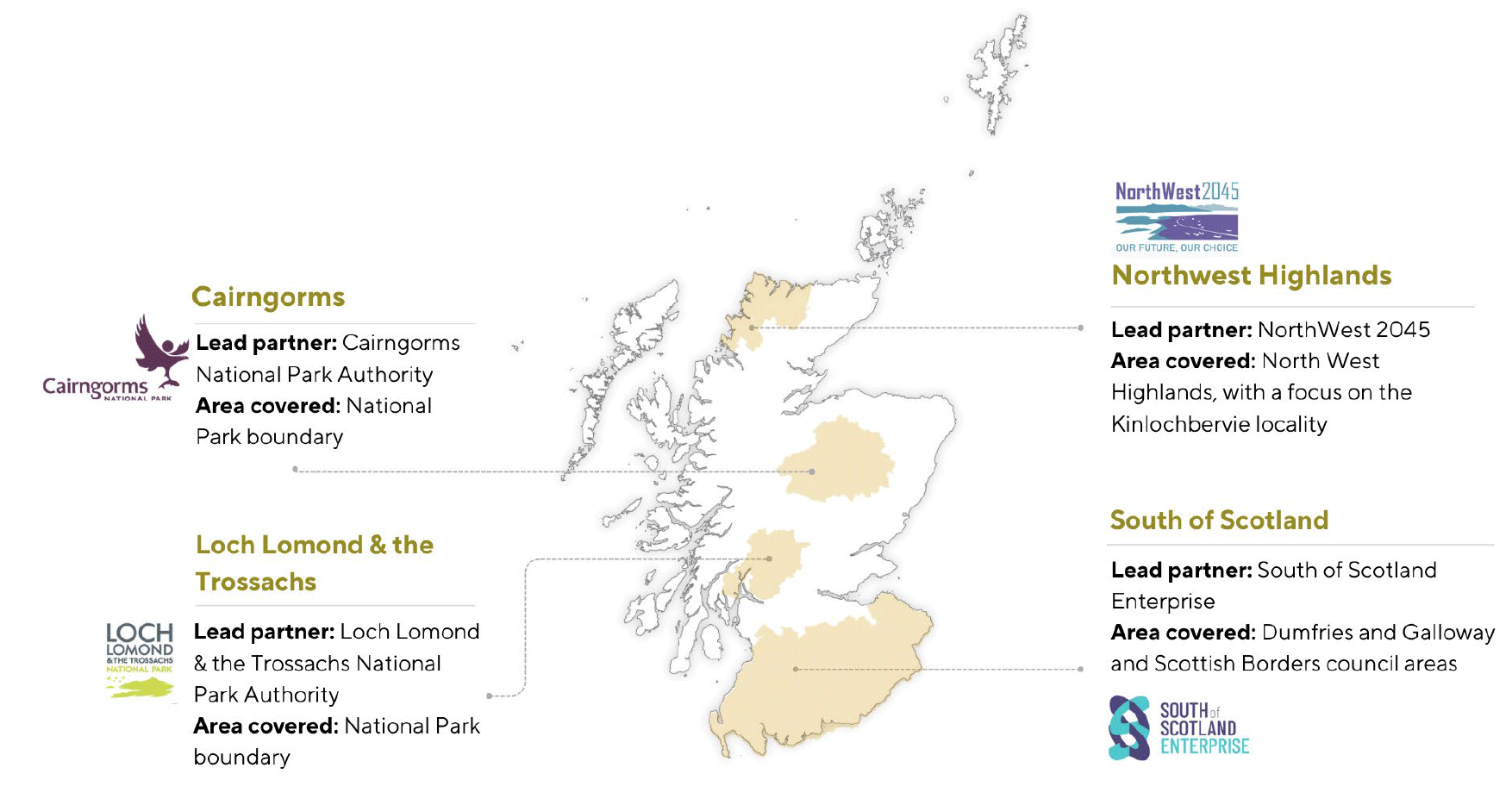
Graphic text below:
Cairngorms
- Lead partner: Cairngorms National Park Authority
- Area covered: national park boundary
Loch Lomond and the Trossachs
- Lead partner: Loch Lomond and the Trossachs National Park Authority
- Area covered: national park boundary
Northwest Highlands
- Lead partner: NorthWest2045
- Area covered: North west Highlands with a focus on the Kinlochbervie locality
South of Scotland
- Lead partner: South of Scotland Enterprise
- Area covered: Dumfries and Galloway and Scottish Borders council areas
Contact
Email: lus4@gov.scot