Orkney Islands Regional Marine Plan
This plan covers the management of the Scottish Marine Region for the Orkney Islands. It guides and supports decision making for development and use of the sea, and represents the second tier of marine planning, following on from the National plan.
Section 2: General Policies
Introduction
2.1 The suite of general policies provides a framework for decision making to help deliver the Plan’s environmental, social, economic, marine ecosystem and community wellbeing objectives. These types of policies are often referred to as cross-cutting policies as they can be applied to many different types of decision, for example decisions on renewable energy, aquaculture or harbour developments, to address a specific policy issue e.g. nature conservation.
2.2 The general policies assist public authorities, including but not limited to, regulators, decision makers and planners, to make decisions on sustainable development and activities that take place within, or that affect, the Orkney Islands marine region.
2.3 The general policies can help to guide applicants preparing proposals for development and activities.
2.4 Section 1 provides relevant information on how to use the Plan’s policy framework.
2.5 Sector policies are contained in Section 3.
Policy structure
2.6 Each policy has an introductory section detailing the intent and context for the policy, and key information about the topic that is particularly relevant to Orkney. The policy is then presented in a clearly defined policy box. The associated text for each policy includes supporting information that should be taken into account in relevant decision making.
2.7 Each policy is supported by an information box that outlines:
- the contribution of the policy to the Plan objectives;
- relevant information in the Orkney Islands Marine Region: State of the Environment Assessment; and
- the policy’s alignment with other key marine and land-use plans.
2.8 Where appropriate, the Plan policies are supported by spatial information in map form or by reference to other relevant spatial information (see Section 1 for details on the use of spatial information and data).
2.9 Appendix 1, which is not exhaustive, identifies the key authorisation and enforcement decisions through which the Plan policies will be implemented.
2.10 A summary of the wider relevant legislation, policies and guidance that should be considered alongside this Plan is provided in Appendix 2, which is not exhaustive.
General Policy 1: Sustainable Development, Activities, and Use
Policy intent
To encourage, promote and facilitate sustainable development, activities, and use.
Context
2.11 This Plan aims to support a thriving Orkney economy and a healthy marine and coastal environment that meets the needs of all our communities. General Policy 1 establishes a presumption in favour of sustainable development and is supported by a suite of general and sector policies to help deliver a sustainable future for Orkney.
2.12 Delivering sustainable marine and coastal development, activities, and use is the fundamental aim of this Plan, in support of the UN Sustainable Development Goals[10], and in conformity with the National Marine Plan 2015[11] and other relevant Scottish Government policy and guidance.
2.13 The Orkney Islands marine region is biologically diverse, productive and contributes significantly to the local and national economy. Orkney’s marine and coastal environment needs to be protected and, where appropriate, enhanced to support the continued delivery of social, economic and environmental benefits for current and future generations. To achieve this, this Plan adopts an integrated approach to land-use and marine planning. It supports the balanced consideration of social, economic and environmental factors in decision making, and the implementation of a just transition to net zero[12], community wealth building[13], a wellbeing economy[14] and the precautionary principle[15].
2.14 This Plan is a key delivery mechanism for Scotland’s Blue Economy Vision[16] in Orkney. Delivering Scotland’s Blue Economy Approach[17] identifies six, equally weighted outcomes, and looks to transition away from conventional thinking that stipulates we must always trade off economic production against environmental protection. Instead, it recognises that one relies on the other – economically productive and thriving marine sectors require a biologically healthy marine environment. This principle is embedded within the approach to sustainable development set out in the vision, aim, objectives and policies in this Plan.
2.15 Marine and coastal development can deliver significant social and economic benefits for host island communities. It can also have significant impacts on the local environment, infrastructure, housing markets, community services and facilities. It is therefore important that social, economic and environmental benefits for Orkney communities are maximised, whilst ensuring that any significant adverse impacts on these communities are appropriately addressed.
2.16 Using sound science responsibly, effective community engagement and valuing local knowledge are principles that underpin the approach to sustainable development in this Plan. The implementation of these principles in decision making will help to deliver sustainable development and sustainable outcomes for Orkney communities.
General Policy 1: Sustainable Development, Activities, and Use
General Policy 1a: Supporting sustainable development
There is a presumption in favour of sustainable development, activities, and use when consistent with the policies and objectives of this Plan.
General Policy 1b: Sustainable development principles
Proposals for development and/or activities should demonstrate:
Maximising benefits
i. that opportunities have been taken to maximise sustainable environmental, social and economic benefits.
Effective community engagement
ii. effective engagement with affected local communities.
Addressing direct and indirect impacts
iii. that any significant adverse direct or indirect environmental, social, economic and/or historic environment impacts or effects have been avoided, minimised and/or appropriately mitigated.
Addressing cumulative impacts
iv. that any significant adverse cumulative environmental, social, economic and/or historic environment impacts or effects have been avoided, minimised and/or appropriately mitigated.
Effective and efficient use of existing infrastructure and services
v. the effective and efficient use of existing infrastructure and/or services.
vi. that such proposals will not create an unacceptable burden on existing infrastructure and/or services that cannot be addressed as part of the consenting process.
Addressing impacts on existing development and marine users
vii. that any significant adverse environmental, social, economic and/or operational effects on existing development, activities and/or use have been avoided, minimised and/or appropriately mitigated.
Using sound science and local knowledge
viii. that sound science and/or evidence has been used responsibly, alongside relevant local knowledge, in the design and assessment of such proposals.
General Policy 1c: The precautionary principle
The precautionary principle should be applied in decision making in accordance with relevant legislation and Scottish Government guidance.
Table 3: General Policy 1 links to Plan objectives, State of the Environment Assessment and other plans
Contribution to Regional Marine Plan objectives
Direct contribution to objectives – 1,2, and 10.
Indirect contribution to objectives – 4, 5, and 8.
Assessment of the condition of the Orkney Islands marine region
Orkney Islands Marine Region: State of the Environment Assessment baseline information - Whole assessment.
Alignment with other marine and land-use plans
National Marine Plan 2015 – GEN 1, GEN 2, GEN 3, GEN 4, GEN 18, GEN 19 and GEN 21.
National Planning Framework 4 – Policy 4 e) and Policy 12 b)i.
Orkney’s Regional Spatial Strategy (Indicative) – Strategic Priority: Sustainable Communities.
Orkney Local Development Plan 2017 – Policy 1.
General Policy 2: Safety
Policy intent
To encourage, promote and facilitate safe development, activities, and use.
Context
2.17 Safety is an important consideration in all aspects of marine traffic, development and activities. As competition for marine space increases due to development, potential impacts on shipping and maritime safety will need to be reconciled. It is recognised that all vessels have the right of innocent passage and freedom of navigation. The safeguarding of routes used by shipping is essential for the viability of island communities.
2.18 The marine safety regime is underpinned by international safety, security and pollution-control regulations and codes issued by the International Maritime Organisation. A series of measures have been introduced to support safety at sea and protection of the marine environment, including conventions, recommendations and other instruments which are implemented in UK waters by the Maritime and Coastguard Agency (MCA).
2.19 Orkney Islands Council, as the statutory harbour authority (Orkney Harbour Authority), has responsibility for safety of navigation within harbour areas (see Map 2), and the MCA has responsibility for facilitating the safety of shipping and seafarers, saving lives, and protecting the maritime environment. Those proposing development and/or activities that could affect navigational safety or harbour operations should therefore liaise with the relevant authority in the early stages of planning.
2.20 Orkney Harbour Authority is responsible for the safe and efficient operation of 29 piers and harbours located throughout the Orkney Islands and operates under the principles set out in the Port Marine Safety Code[18] (‘the Code’). The Code sets out a national standard for every aspect of port marine safety. Whilst not mandatory, it is endorsed by the UK Government and the devolved administrations; these bodies have a strong expectation that all harbour authorities will comply. The Code is applicable both to statutory harbour authorities and to other marine facilities which may not have statutory powers and duties.
2.21 The Orkney Harbour Authority Marine Safety Management System accords with the Code and includes safety management systems maintained by other operators (e.g. towage and ferries) and commercial marine operations within the Orkney harbour areas (e.g. Flotta Oil Terminal). Details can be found in the Orkney Harbour Authority Marine Safety Management System Manual[19].
2.22 Orkney Islands Council has a duty under the Control of Major Accident Hazards Regulations 2015 (COMAH) to prepare an off-site emergency plan for the Flotta Oil Terminal. The aim of the off-site emergency plan is to limit the consequences of any major accident or incident for people working and/or residing on the island of Flotta.
2.23 Under a Memorandum of Understanding between the Health and Safety Executive (HSE) and the MCA, there are consultation zones around licensed piers in Orkney, to help ensure that appropriate safety measures are in place relating to the transportation of hazardous goods. These piers and associated HSE consultation zones (see Map 2) are licensed by the HSE under the Dangerous Goods in Harbour Areas Regulations 2016. Planning authorities consult HSE directly for advice on developments located within consultation zones and developments in the vicinity of major accident hazard sites[20] (see Map 2).
General Policy 2: Safety
i. The Orkney Harbour Authority should be consulted on proposals for development and/or activities that would have implications for any aspect of safety in harbour areas.
Table 4: General Policy 2 links to Plan objectives, State of the Environment Assessment and other plans
Contribution to Regional Marine Plan objectives
Direct contribution to objectives – 6, 7, and 8.
Indirect contribution to objectives – 2.
Assessment of the condition of the Orkney Islands marine region
Orkney Islands Marine Region: State of the Environment Assessment baseline information – Sections 6.4 and 6.6.3.
Alignment with other marine and land-use plans
National Marine Plan 2015 – Safety is a cross-cutting policy matter within the National Marine Plan.
National Planning Framework 4 – Policy 23 g).
Orkney’s Regional Spatial Strategy (Indicative) – N/A.
Orkney Local Development Plan 2017 – Policy 1vi.
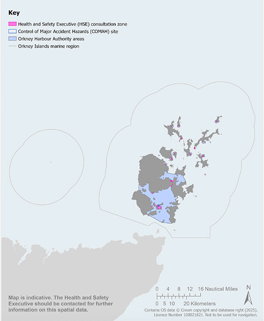
Map 2 Health and Safety Executive consultation zones and COMAH site: Map is indicative. The Health and Safety Executive should be contacted for further information on this spatial data. Map 2 does not have publicly available data.
General Policy 3: Climate Change
Policy intent
To encourage, promote and facilitate development, activities, and use that minimise greenhouse gas emissions, and that are adapted to the current and future impacts of climate change.
Context
2.24 Climate change is the most critical factor affecting Scotland’s marine environment, businesses and coastal communities. Its effects are many and far-reaching, including changing weather patterns, sea level rise causing increased flooding and coastal erosion, and changes to the sea’s temperature and acidification levels. All these factors affect the environment, economy, communities and species’ ecology in numerous ways.
2.25 The world’s oceans play a significant role in climate regulation, absorbing 93% of the heat that accumulates in the earth’s atmosphere and around a quarter of the carbon dioxide released from fossil fuels. Sea surface temperature around the UK generally shows a significant warming trend of around 0.3°C per decade over the last 40 years and these warming trends are predicted to continue[21], and contribute to changing ocean circulation systems[22]. Sea levels are predicted to rise between 1.01m and 1.07m around Orkney by 2100 under the high emissions scenario[23].
2.26 The Orkney Partnership (Orkney's Community Planning Partnership) vision is a future which meets the challenges of climate change head on, by doing everything the partnership can to ensure that Orkney is ahead of the curve, aiming for Net Zero Emissions by 2030 and a fully decarbonised (zero carbon) island economy by 2045. Orkney aspires to play a leading part in achieving a just transition where our economy, communities and natural environment all prosper and benefit, building their resilience, and adapting to the changing climate[24].
2.27 This Plan supports greenhouse gas reduction measures, a rapid and just transition to zero carbon energy generation and zero fossil carbon fuels, climate change adaptation, sustainable economic development, activities, and use, and, compliance with public authorities’ climate change duties.[25] The Plan integrates with wider strategic policy to support the transformational change required to address the Global Climate Emergency[26], including but not limited to; the Climate Change Plan update, Scottish National Adaptation Plan 2024-2029, NPF4, National Marine Plan 2015, and the Orkney Local Development Plan 2017 (see Appendix 2).
2.28 NPF4, published in February 2023, introduced a change in national planning policy by giving significant weight to the climate crisis in decision making on development proposals. National Marine Plan 2015 policy GEN 5 Climate change states that marine planners and decision makers must act in the way best calculated to mitigate, and adapt to, climate change. In 2019, the Scottish Government and Orkney Islands Council declared a climate emergency. In response to these policy drivers, General Policy 3a: Climate crisis gives significant weight in decision making on development and activity proposals to the global climate crisis.
2.29 Climate change mitigation measures are those actions taken to reduce greenhouse gas emissions or re-capture previous emissions, while adaptation measures aim to reduce the vulnerability of people, infrastructure and/or nature to the effects of climate change. Mitigation, therefore, attends to the causes of climate change, while adaptation addresses its impacts[27]. Some climate change effects can be reduced by various mitigation measures, while adaptation measures can help limit the impact of climate change consequences that are already ‘locked-in’ due to past emissions.
2.30 Mitigation measures include:
- practising energy efficiency.
- displacing fossil-fuel use through greater and more diverse use of renewable energy and e-fuels, for example, to electrify industrial processes or to support use of alternative energy for transport, such as hybrid or hydrogen ferries.
- capture and storage of excess atmospheric carbon, particularly in natural and semi-natural habitats.
2.31 Adaptation measures include:
- adapting existing and future coastal development, activities and infrastructure to be more resilient against climate change impacts, e.g. sea level rise.
- relocating facilities and infrastructure to secure locations, e.g. away from areas affected by coastal flooding and erosion.
- research and development on possible climate change scenarios, e.g. modelling the effects of sea level rise in coastal areas or temperature impacts on the behaviour and distribution of commercially viable species.
- preventive and precautionary measures, e.g. emergency planning and flood warning systems.
- building capacity for more diverse marine and coastal business activities, enabling communities to adapt to climate-related stresses, both within sectors (e.g. fishers targeting a wider range of species) and between sectors (e.g. ability to shift to alternative activity).
- safeguarding and, where appropriate, restoring blue carbon habitats as part of development and activities or habitat-enhancement projects[28].
2.32 Enhancing local resilience to the effects of climate change is a key priority. Resilience is the capacity of social, economic and environmental systems to cope with a hazardous event, trend or disturbance, responding or reorganising in ways that maintain their essential function, identity and structure, while also maintaining the capacity for adaptation, learning and transformation[29]. A key part of the vision for this Plan is that Orkney’s marine and coastal environment is managed sustainably to support thriving and resilient local communities.
2.33 The ecosystem services provided by a healthy functioning coastal and marine environment (e.g. coastal protection and carbon sequestration and storage) are under threat from the effects of climate change and other pressures. For example, disturbance of blue carbon habitats by development, activities, and use can release further emissions and reduce the capacity of these habitats to store and sequester carbon. On the other hand, habitat restoration measures have the potential to mitigate adverse effects of climate change and are an example of enabling climate change resilience. Appendix 4 provides further information on ecosystem services from coastal and marine habitats and species.
2.34 The Orkney Islands Marine Region: State of the Environment Assessment[30] provides information on the main climate change issues and pressures in Orkney’s coastal and marine areas. These include sea level rise and coastal change, sea temperature increases, changes in salinity and acidification, flooding, and impacts on habitats that are potential blue carbon stores[31].
2.35 A Flood Risk Management Plan is produced by the Scottish Environment Protection Agency (SEPA) to identify areas of flood risk within each Local Plan District, including Orkney. This plan is then consulted upon with partners (known as Responsible Authorities) to identify actions to address the identified risks. The most recent Flood Risk Management Plan for the Orkney Local Plan District (LPD3) was produced in 2021[32]. In relation to flooding issues, SEPA can provide guidance on climate change adaptation requirements for development.
2.36 The Orkney Islands Regional Marine Plan is a case study within the Marine Spatial Planning Addressing Climate Effects (MSPACE) programme[33]. The MSPACE programme is designed to drive forward the implementation of climate-smart marine spatial planning in the UK. It utilises state of the art analyses of climate change impact modelling projections to consider how climate change will affect the conservation, fisheries and aquaculture sectors. The models enable the identification of climate change hotspots for these sectors, where climate pressures drive an ecosystem into a new state beyond its natural variability, and refugia areas that exhibit long term resilience to climate change. When completed in December 2025, the MSPACE programme will include recommendations for climate-smart marine spatial planning which will inform future marine planning in Orkney.
General Policy 3: Climate Change
General Policy 3a: Climate crisis
When considering proposals for development and/or activities, significant weight in decision making should be given to the global climate crisis including measures for mitigation and adaptation.
General Policy 3b: Climate change mitigation
Proposals for development and/or activities should demonstrate that measures have been taken to mitigate climate change including, where appropriate, measures to minimise greenhouse gas emissions over the proposal’s life cycle as far as possible.
General Policy 3c: Climate change adaptation and resilience
Proposals for development and/or activities should demonstrate that:
i. measures have been taken to adapt to climate change;
ii. climate change adaptation and resilience measures have been built into the project over its lifetime; and
iii. they include, where appropriate, nature-based solutions to enhance the resilience of infrastructure, coastal communities and/or the environment to the effects of climate change.
Table 5: General Policy 3 links to Plan objectives, State of the Environment Assessment and other plans
Contribution to Regional Marine Plan objectives
Direct contribution to objectives – 3, and 4.
Indirect contribution to objectives – 1, 2, 5, 6, 7, and 8.
Assessment of the condition of the Orkney Islands marine region
Orkney Islands Marine Region: State of the Environment Assessment baseline information – Section 4.
Alignment with other marine and land-use plans
National Marine Plan 2015 – GEN 5.
National Planning Framework 4 – Policies 1 and 2.
Orkney’s Regional Spatial Strategy (Indicative) – Strategic Priority: Climate Emergency.
Orkney Local Development Plan 2017 – Policies 12 and 13.
General Policy 4: Supporting Sustainable Social and Economic Benefits
Policy intent
To encourage, promote and facilitate development, activities, and use that delivers sustainable social and economic benefits in local communities.
Context
2.37 Marine planning and decision making have an important role in enabling social and economic opportunities to be realised by supporting the achievement of national and local aspirations for sustainable economic development. A significant challenge for marine planning and decision making is balancing the requirements of existing coastal and marine users, and the needs of growing, or potentially novel, economic sectors, to deliver sustainable social, economic and environmental benefits. Marine planning and decision making can help to avoid, minimise and mitigate adverse socio-economic impacts, maximise benefits and deliver synergies between new and existing development, activities and use.
2.38 Job creation and increased economic activity can have a transformative impact on the viability and sustainability of island communities. It is therefore important that every community in Orkney benefits from sustainable economic development opportunities. The growth of the marine economy, including upstream and downstream businesses, should create jobs, support skills development and wider economic activity in Orkney’s North and South Isles, as well as the Mainland and barrier-linked island communities.
2.39 General Policy 4 aims to support the delivery of the core principles of community wealth building. This approach prioritises local economic benefits and retaining wealth within local communities. Community wealth building is a people-centred approach to local economic development, which redirects wealth back into the local economy, and places control and benefits into the hands of local people. The Orkney Partnership’s target outcomes for sustainable development include supporting community wealth building to achieve an upturn in Orkney’s economy, to ensure wealth is retained in Orkney and that this wealth is shared fairly[34]. During the lifetime of this Plan, Orkney Islands Marine Region: Supporting Sustainable Social and Economic Benefits Guidance may be adopted to help guide the implementation of General Policy 4.
General Policy 4: Supporting Sustainable Social and Economic Benefits
General Policy 4a: Supporting sustainable social and economic benefits
Proposals for development and/or activities should demonstrate that:
i. opportunities have been considered to maximise sustainable employment benefits and create skilled employment in local communities;
ii. opportunities have been considered to support local businesses, skills development, supply chains and research and development;
iii. opportunities have been considered to support synergistic benefits with existing marine and coastal development, activities and use; and
iv. the social and economic benefits of the proposal outweigh any significant adverse impacts on existing social and/or economic activities.
General Policy 4b: Impacts on local infrastructure, services and other marine and coastal users
Developers should undertake early engagement with the local authority, any other relevant bodies, service providers and/or stakeholders if significant impacts on local infrastructure, services and/or the activities of other coastal and marine users are likely to result from proposed development and/or activities.
General Policy 4c: Supporting sustainable social and economic benefits guidance
Proposals for development and/or activities should have regard to the Orkney Islands Marine Region: Supporting Sustainable Social and Economic Benefits Guidance, where available.
Table 6: General Policy 4 links to Plan objectives, State of the Environment Assessment and other plans
Contribution to Regional Marine Plan objectives
Direct contribution to objectives – 1, 3, 5, 8, and 10.
Indirect contribution to objectives – 7, and 9.
Assessment of the condition of the Orkney Islands marine region
Orkney Islands Marine Region: State of the Environment Assessment baseline information –Sections 6, and 7.
Alignment with other marine and land-use plans
National Marine Plan 2015 – GEN 1, GEN 2, GEN3 and GEN 4.
National Planning Framework 4 – Policy 25 a).
Orkney’s Regional Spatial Strategy (Indicative) – Strategic Priority: Thriving Economy.
Orkney Local Development Plan 2017 – Policies 1, 9 and 12.
General Policy 5: Safeguarding Natural Capital and Ecosystem Services
Policy intent
To safeguard and enhance natural capital and ecosystem services.
Context
2.40 Orkney’s marine environment is affected by multiple pressures from human activities. These pressures need to be effectively managed to prevent a decline in the health and functioning of natural capital assets and the many benefits local communities derive from these assets. This Plan aims to protect and enhance natural capital, biodiversity and ecosystem services for current and future generations.
2.41 The Orkney Islands Marine Region: State of the Environment Assessment[35] presents a summary of the environmental pressures and impacts of human activities affecting the Orkney Islands marine region. Many of the features that contribute to the health of the marine environment in Orkney are in relatively good condition. However, there are a number of concerns relating to climate change, impacts on biodiversity from a variety of anthropogenic sources, and an increasing demand for development and use of marine space.
Natural capital is the stock of renewable and non-renewable natural resources (e.g. animals, air, water, soils, minerals) that combine to yield a flow of benefits to people that are often referred to as ecosystem services.
2.42 As well as having its own intrinsic value, Orkney’s coastal and marine environment is rich in natural resources which provide a wide range of ecosystem services, supporting local communities, health and well-being, and underpin the economy. These ecosystem services are provided by many of Orkney’s habitats and species such as maerl beds, kelp beds and seagrass. For example, kelp beds in Orkney provide a habitat to support nursery grounds for fish, crustaceans and invertebrates and a diverse marine community. As well as protecting gene pools, kelp beds provide a regulatory service through carbon cycling and a cultural service through kelp’s importance to the Orkney community for its heritage value[36]. In addition to considering impacts on individual receptors (e.g. a Priority Marine Feature), a more holistic approach should be taken to decision making on development and activities by considering potential impacts at an ecosystem scale, for example, impacts on prey species affecting the availability for predators to feed.
Ecosystem services are processes by which the environment produces resources that are utilised by humans, such as clean air, water, food, energy and materials. A well-functioning marine ecosystem supports these vital ecosystem services
2.43 Marine biodiversity enhancement activities should have regard to the appropriate guidance provided by NatureScot[37].
2.44 During the lifetime of this Plan, Orkney Islands Marine Region: Natural Capital and Ecosystem Services Guidance may be adopted to guide the implementation of General Policy 5.
2.45 Appendix 4 identifies ecosystem services provided by the marine environment.
General Policy 5 : Safeguarding Natural Capital and Ecosystem Services
Proposals for development and/or activities should:
i. demonstrate, where appropriate, that significant adverse impacts on coastal and/or marine natural capital and ecosystem services have been avoided, minimised and/or appropriately mitigated.
ii. include, where appropriate, measures to maintain and enhance coastal and/or marine natural capital and ecosystem services.
iii. have regard to the Orkney Islands Marine Region: Natural Capital and Ecosystem Services Guidance, where available.
Table 7: General Policy 5 links to Plan objectives, State of the Environment Assessment and other plans
Contribution to Regional Marine Plan objectives
Direct contribution to objectives – 2.
Indirect contribution to objectives – 3, 4, and 5.
Assessment of the condition of the Orkney Islands marine region
Orkney Islands Marine Region: State of the Environment Assessment baseline information – Sections 2, 4 and 5.
Alignment with other marine and land-use plans
National Marine Plan 2015 – Para 4.39, Annex A.
National Planning Framework 4 – Policy 3.
Orkney’s Regional Spatial Strategy (Indicative) – Strategic Priority: An Outstanding Environment and Quality of Life.
Orkney Local Development Plan 2017 – Policy 9C.
General Policy 6: Water Environment
Policy intent
To protect the water environment and improve the ecological status of coastal waterbodies.
Context
2.46 High quality marine waters and benthic habitats are essential for a healthy environment, a successful economy and recreational activities. It is vital to maintain and, where possible, enhance this quality, as it underpins the current and future growth of the marine economy and the well-being of local communities. A high-quality water environment supports rich biodiversity and a variety of essential ecosystem services. Under the Water Environment and Water Services (Scotland) Act 2003, Scottish Ministers and every public body and office-holder must, in exercising any functions, have regard to the desirability of protecting the water environment.
2.47 The Scotland River Basin District (Standards) Directions 2024[38] and the Scotland River Basin District (Status) Directions 2024[39] direct the SEPA regarding the application of environmental standards for the water environment including environmental standards for the purposes of assessing the ecological status of water bodies. Assessing Scotland's water environment – use of environmental standards, condition limits and classification schemes – Policy Statement[40] sets out how SEPA should implement the Water Environment and Water Services (Scotland) Act 2003, using the Directions from 2024.
2.48 The River Basin Management Plans (RBMP)[41], coordinated by SEPA, promote sustainable water use, whilst protecting and improving the water environment. These plans cover inland waters, groundwater, lochs, estuaries, and coastal waters out to three nautical miles. Therefore, there is a spatial overlap and a requirement for alignment and integration with regional marine plans. Under RBMP, Orkney’s coastal waters are classified as good or high for water quality (see Maps 3–5).
2.49 The classification of coastal waterbodies includes assessment of ecological, chemical and physical parameters, using available data, for factors including water quality and physical condition (i.e. the assessment of coastal engineering), as well as biological parameters, the presence of invasive non-native species, and benthic monitoring results. The benthic environment is characterised by animal and plant communities with no, or slow, mobility that rely on the seabed to feed, hide, rest and reproduce, as well as by areas of high exposure with strong tidal influences. Developments that place structures on the seabed, or activities such as deposition from aquaculture, dredging and trawling, have the potential to cause removal of habitat, smothering and abrasion. If not managed appropriately, these developments, activities and uses can have significant impacts on benthic habitats and species, including Priority Marine Features (PMFs) (see Appendix 5), and on some qualifying features of designated nature conservation sites.
General Policy 6: Water Environment
Proposals for development and/or activities should:
i. be accompanied by sufficient information to enable an assessment of the likely effects, including cumulative effects, on water quality and the benthic environment.
ii. take existing activities that affect water quality in the proposed location into account, and demonstrate early engagement with relevant stakeholders, to ensure that suitable mitigation is provided for potentially incompatible activities, and where that is not possible, that they are not co-located.
iii. not cause any waterbody to deteriorate in status nor prevent the achievement of objectives in the River Basin Management Plan for the Scotland river-basin district.
iv. consider contributing, where possible, towards objectives to improve the ecological status* of coastal waterbodies and the environmental standard** of marine waters.
* Ecological status in surface waters | WISE Freshwater
** EU policies to protect Europe’s ocean, seas and coasts
Table 8: General Policy 6 links to Plan objectives, State of the Environment Assessment and other plans
Contribution to Regional Marine Plan objectives
Direct contribution to objectives – 2, and 8.
Indirect contribution to objectives – 5, and 7.
Assessment of the condition of the Orkney Islands marine region
Orkney Islands Marine Region: State of the Environment Assessment baseline information – Section 2.3.
Alignment with other marine and land-use plans
National Marine Plan 2015 – GEN 12.
National Planning Framework 4 – Policy 22.
Orkney’s Regional Spatial Strategy (Indicative) – Strategic Priority: An Outstanding Environment and Quality of Life.
Orkney Local Development Plan 2017 – Policy 9D.
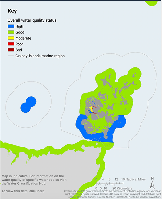
Map 3 Waterbody classification: Water quality status: Map is indicative. For information on water quality of specific water bodies visit the Water Classification Hub.
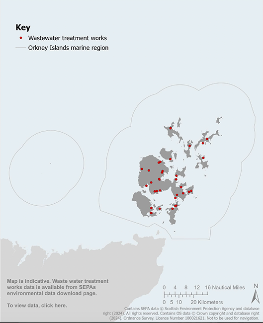
Map 4 Wastewater treatment works: Map is indicative. Waste water treatment works data is available from SEPAs environmental data download page
Map 5 Scottish Pollutant Release Inventory (SPRI) locations: Map is indicative. An interactive version of the data in this map can be found on NMPi. Updated data sets will be added to NMPi when available.
General Policy 7: Coastal Development and Coastal Change
Policy intent
To protect and enhance the coastal environment, communities and assets, and support resilience to the impacts of climate change.
Context
2.50 The water masses of the North Sea and the Atlantic Ocean meet in Orkney waters producing diverse hydrodynamic conditions. The Sounds between the islands create extraordinarily strong tidal flows, and the exposed coasts experience powerful wave action. These forces create the geographical and physical diversity of Orkney’s coast and associated habitats, species and marine resources.
2.51 Orkney’s western seaboard is characterised by dramatic sea cliffs and associated arches, stacks, geos and gloups. The lower-lying coastal areas are dominated by tilted flags, dune systems and sandy bays. There are numerous indented bays that expose these lower-lying areas to coastal flooding and erosion. The main source of flooding in Orkney is from coastal flooding, which accounts for approximately 94% of the annual average damage by flood[42].
2.52 Orkney Islands Council produces the Orkney Local Flood Risk Management Plan[43]. It outlines the various responsibilities and actions required of agencies such as SEPA, Scottish Water and the local authority to meet the objectives of the strategy. The primary responsibility to protect land from flooding, including coastal land, lies with the landowner.
2.53 Coast protection authorities, which is Orkney Islands Council in the case of Orkney, are permitted to undertake maintenance and emergency work under the terms of the Coast Protection Act 1949, and certain public bodies are expected to take a proactive role in managing and, where achievable, lowering overall flood risk. Local authorities have discretionary powers to carry out coast protection work that they consider to be necessary or expedient for the protection of any land in their area against erosion and encroachment by the sea.
2.54 The rate of coastal change is influenced by a changing climate. Dynamic Coast[44] is a Scottish Government project that monitors Scotland’s erodible shore. It has investigated coastal erosion and flood risk, under the Intergovernmental Panel on Climate Change high emissions, medium emissions and low emissions future scenarios. The data identifies coastal areas and assets at risk from coastal erosion and flooding. Since the 1970s, the average rate of coastal erosion has increased significantly in Orkney, particularly in areas of soft substrate, such as sand, soils and clays. In Orkney, 61% of the coast is categorised as hard, 36% is categorised as soft and 3% as artificial. Given that many of Orkney’s settlements and infrastructure are in low-lying soft coast areas, there is a need to plan ahead for predicted sea level rise, and the increased risk of coastal erosion and flooding.
2.55 The Dynamic Coast project encourages Local Development Plan policy changes to ensure that any development avoids the disturbance or degradation of coastal landforms[45] and encourages society to become ‘sea level wise’[46]. This work recognises the crucial role that habitats such as beaches, dune systems, saltmarshes and kelp beds play as natural defences against coastal erosion and flooding. Key sites such as the Bay of Skaill are particularly vulnerable, as Mean Low Water Springs in the southern third of the Bay has moved landward, with suggested associated increase in flood risk[47].
2.56 In 2025, Orkney Islands Council commenced the preparation of a Coastal Change Adaptation Plan (CCAP) for Orkney to identify and evaluate specific areas that are susceptible to coastal flooding and erosion, both currently and into the future. The plan making process will investigate potential options for future actions to increase the resilience of coastal areas in the short, medium and long term, as well as identifying trigger points for taking specific strategic actions. This CCAP will serve as a vital tool to support adaptive decision making, now and into the future, in partnership with local communities.
General Policy 7: Coastal Development and Coastal Change
General Policy 7a: Coastal Development
Proposals for development and/or activities located on, or directly adjacent to, the coast should have regard to:
a. The National Planning Framework;
b. The Orkney Local Development Plan;
c. The Orkney Local Flood Risk Management Plan;
d. The Coastal Change Adaptation Plan (where available); and
e. Dynamic Coast data and maps.
General Policy 7b: Coastal processes
Proposals for development and/or activities that would significantly affect coastal processes should demonstrate that:
i. significant adverse effects on coastal and marine habitats, species and geomorphological features, including, but not limited to, those that are caused by erosion, compaction, sediment transport, accretion, scouring, deposition and/or coastal flooding, have been avoided, minimised and/or appropriately mitigated.
ii. significant adverse effects from the proposal on existing coastal and marine infrastructure and other assets, due to coastal erosion, flooding and/or wider coastal change, have been avoided, minimised and/or appropriately mitigated.
General Policy 7c: Coastal protection
Development and/or activities proposals for coastal protection/defence measures should:
i. be consistent with the policies and objectives of this Plan, the National Planning Framework, the National Marine Plan, the Orkney Local Development Plan, the Orkney Local Flood Risk Management Plan and any relevant Coastal Change Adaptation Plan.
ii. have regard to the Dynamic Coast data and maps.
iii. utilise nature-based solutions and permit managed future coastal change wherever practical.
iv. demonstrate that any in-perpetuity hard defence measures are necessary to protect essential assets.
v. avoid, minimise and/or appropriately mitigate significant adverse effects on habitats and coastal geomorphological features that provide significant coastal protection services for infrastructure and other assets, and should where appropriate, enhance the functioning of these habitats and features.
Table 9: General Policy 7 links to Plan objectives, State of the Environment Assessment and other plans
Contribution to Regional Marine Plan objectives
Direct contribution to objectives – 2, and 4.
Indirect contribution to objectives – 9.
Assessment of the condition of the Orkney Islands marine region
Orkney Islands Marine Region: State of the Environment Assessment baseline information – Section 2.2.
Alignment with other marine and land-use plans
National Marine Plan 2015 – GEN 5 and GEN 8.
National Planning Framework 4 – Policies 5 a) and 10.
Orkney’s Regional Spatial Strategy (Indicative) – Strategic Priority: Sustainable Communities; Strategic Priority: Climate Emergency.
Orkney Local Development Plan 2017 – Policy 13.
General Policy 8: Historic Environment
Policy intent
To protect and enhance the historic environment.
Context
2.57 The historic environment includes any physical evidence of human activity through time. Orkney is world renowned for the quality and quantity of its historic environment assets, both terrestrial and marine. This policy addresses impacts from development and/or activities on the historic environment. The impacts of physical processes on the historic environment, such as erosion and storm damage, which are likely to be exacerbated by climate change, are further addressed in General Policies 3 and 7.
2.58 Archaeological records in Orkney date back as early as c.7000 BC, and include Neolithic settlements and tombs, Iron Age tower houses of the broch villages, and a rich Viking heritage of international significance. More recently, Orkney played a pivotal role in both World Wars, leaving poignant reminders of these turbulent periods etched on our seascape and coastal areas in the shape of wrecks, barriers, gun emplacements and concrete bunkers. The wrecks of the German High Sea Fleet in Scapa Flow are afforded protection as scheduled monuments; and there is a Scapa Flow Historic Marine Protected Area (Historic MPA) in recognition of its nationally important marine historic assets.
2.59 Examples of important historic environment assets around Orkney include the Heart of Neolithic Orkney World Heritage Site; scheduled monuments; listed buildings; gardens and designed landscapes; and controlled sites and protected places, including designated military maritime graves. The seabed is also of palaeo-environmental interest, particularly areas that were once dry land during ice age conditions and where there is potential for a wide range of buried deposits of archaeological interest. Drowned palaeolandscapes are rare in Scotland and are a distinctive feature of Orkney’s marine heritage.
2.60 Historic environment assets and places (both designated and non-designated) are of historical, cultural, economic and recreational interest to Orkney communities and to the thousands that come to visit the islands. It is therefore vital for Orkney to protect its historic environment wherever possible. Trove.scot provides an online catalogue to Scotland’s designated and undesignated archaeology, buildings, industrial and maritime heritage[48].
2.61 Many historic assets and places are afforded legal protection through various national and international designations. The Historic Environment Policy for Scotland is also a key policy consideration for decision making in the whole of the historic environment[49]. To support the implementation of this policy, Historic Environment Scotland has published practical guidance on conserving underwater heritage[50].
2.62 Planning and licensing authorities are advised by Historic Environment Scotland (HES) on matters affecting historic environment assets. The Orkney Islands Council Islands Archaeologist can advise on matters affecting Orkney’s historic environment assets. Developers are recommended to undertake early engagement with HES and the Islands Archaeologist on these matters. The licensing requirements for controlled sites and protected places are administered by the Ministry of Defence (see Map 6 and Appendix 1).
2.63 The National Register of Historic Vessels provides an overview of the UK’s surviving historic vessels[51].
General Policy 8: Historic Environment
General Policy 8a: Historic assets and places
i. Proposals for development and/or activities affecting the historic environment should, where relevant, have regard to:
a. The National Planning Framework; and
b. The Orkney Local Development Plan.
ii. Proposals for development and/or activities with a potentially significant impact on historic assets or places should be accompanied by an assessment* which is based on an understanding of the cultural significance of the historic asset and/or place. The assessment should identify the likely visual or physical impact of any proposals for change, including cumulative effects, and provide a sound basis for managing the impacts of change.
iii. Proposals should also be informed by national policy and guidance on managing change in the historic environment, and information held within Historic Environment Records.
iv. Proposals for development and/or activities should, where appropriate, include a Protocol for Accidental Archaeological Discoveries (PAD)**.
*Where relevant, for EIA development and/or activities refer to: Historic Environment Scotland: Environmental Impact Assessment Handbook
**For example: The Crown Estate: Archaeological Written Schemes of Investigation for Offshore Wind Farm Projects
General Policy 8b: Recording
i. Where developments and/or activities are permitted in areas known to contain, or where there are reasonable grounds to believe they contain, archaeological deposits, conditions may be attached to a licence or consent to ensure the effective assessment, analysis, archiving and publication of any archaeological remains to an agreed timeframe.
ii. Where a historic environment asset, or a significant element thereof, will be lost as a result of a development and/or activity, it may be necessary to record the site to an agreed level prior to the commencement of development and/or demolition.
General Policy 8c: Heart of Neolithic Orkney World Heritage Site
i. Proposals for development and/or activities affecting the Heart of Neolithic Orkney World Heritage Site or its setting should demonstrate that the Outstanding Universal Value*** is protected and preserved.
*** Heart of Neolithic Orkney Statement of Outstanding Universal Value
General Policy 8d: Historic MPA
Development and/or activities capable of affecting a Historic MPA will be managed in accordance with the requirements of the Marine (Scotland) Act 2010.
General Policy 8e: Controlled sites and protected places
The protection of controlled sites and protected places will be managed in accordance with the requirements of the Protection of Military Remains Act 1986.
General Policy 8f: Scheduled monuments
Proposals for development and/activities that will affect scheduled monuments should:
i. avoid direct impacts on the scheduled monument; and
ii. avoid significant adverse impacts on the integrity of the setting of the scheduled monument; or
iii. demonstrate that there are exceptional circumstances to justify the impact on the scheduled monument and/or its setting, and that impacts on the monument or its setting have been minimised.
General Policy 8g: Listed buildings
i. Development and/or activities proposals for the reuse, alteration or extension of a listed building should preserve its character, special architectural or historic interest and setting.
ii. Development and/or activities proposals affecting the setting of a listed building should preserve its character, and its special architectural or historic interest.
General Policy 8h: Conservation areas
Proposals for development and/or activities in or affecting a conservation area should preserve or enhance the character and appearance of the conservation area and its setting. Relevant considerations include the:
i. architectural and historic character of the area;
ii. existing density, built form and layout; and
iii. context and siting, quality of design and suitable materials.
Proposals for development and/or activities in or affecting conservation areas should ensure that existing natural and built features which contribute to the character of the conservation area and its setting are retained.
General Policy 8i: Inventory gardens and designed landscapes
Proposals for development and/or activities should preserve or enhance the character and features of inventory gardens and designed landscapes and their setting. Development and/or activities should not have a significant adverse impact upon the character of these areas.
General Policy 8j: Non-designated historic environment assets
Non-designated historic environment assets and their setting should be protected and preserved in situ wherever feasible. Where there is potential for non-designated remains to exist at a development site, developers should provide an evaluation of the archaeological resource at an early stage so that impacts can be assessed. Where impacts from development and/or activities cannot be avoided, they should be minimised and appropriately mitigated.
Table 10: General Policy 8 links to Plan objectives, State of the Environment Assessment and other plans
Contribution to Regional Marine Plan objectives
Direct contribution to objectives – 5,6, and 7.
Indirect contribution to objectives – 9.
Assessment of the condition of the Orkney Islands marine region
Orkney Islands Marine Region: State of the Environment Assessment baseline information – Section 5.
Alignment with other marine and land-use plans
National Marine Plan 2015 – GEN 6.
National Planning Framework 4 – Policy 7.
Orkney’s Regional Spatial Strategy (Indicative) – Strategic Priority: An Outstanding Environment and Quality of Life.
Orkney Local Development Plan 2017 – Policy 18.
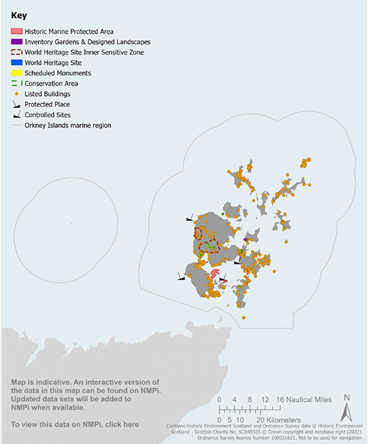
Map 6 Protected coastal and marine historic environment assets: Map is indicative. An interactive version of the data in this map can be found on NMPi. Updated data sets will be added to NMPi when available.
General Policy 9: Nature
Policy intent
To protect and enhance biodiversity and the health of the natural environment.
Context: Background
2.64 The Orkney Islands marine region is home to a range of internationally, nationally and locally important marine and coastal natural heritage features and designated sites. As well as its conservation importance, a healthy, biodiverse marine environment is essential for providing ecosystem services, enhancing well-being and supporting a sustainable marine economy. Further information on the importance and condition of the natural heritage in the region can be found within the Orkney Islands Marine Region: State of the Environment Assessment[52].
2.65 The Global Assessment Report on Biodiversity and Ecosystem Services[53] has highlighted significant pressures on global biodiversity; this significant issue is referred to in this Plan as the nature crisis. Some of the drivers of biodiversity loss include changing use of land and sea, direct exploitation of organisms, and climate change.
2.66 Under the Nature Conservation (Scotland) Act 2004, public bodies in Scotland have a duty to further the conservation of biodiversity, so far as is consistent with the proper exercise of their functions[54].
2.67 The Environment Strategy for Scotland[55] sets an ambitious vision for 2045: ‘By restoring nature and ending Scotland’s contribution to climate change, our country is transformed for the better, helping to secure the wellbeing of our people and planet for generations to come.’ Steps to deliver this vision are set out in the Scottish Biodiversity Strategy to 2045 and supporting Delivery Plan 2024 to 2030[56], which signals the Scottish Government ambitions for tackling the twin crises of climate change and biodiversity loss. There is scope for marine planning policy to reflect the 2045 target set out above, in the way that it guides development, activities and use of the marine and coastal environment, including potential enhancement[57].
2.68 NPF4, published in February 2023, introduced a change in national planning policy by giving significant weight to the global nature crisis in decision making on development proposals. The Scottish Biodiversity Strategy highlights that loss of species and the degradation of our natural environment calls for urgent action. In response to these policy drivers, General Policy 9a: Nature crisis gives significant weight in decision making on development and activity proposals to the global nature crisis.
Context: Protected sites
2.69 In order to protect internationally and nationally identified important natural features under different types of legislation, marine and coastal areas have been designated. Local Nature Conservation Sites have also been identified in the Orkney Local Development Plan (see Table 11 and Maps 7–8). Information on Orkney’s designated sites, including their qualifying features and site condition, can be accessed on SiteLink[58].
Table 11: Types of designated sites in Orkney
International Sites
Special Areas of Conservation and Special Protection Areas – Special Protection Areas (SPAs), designated for birds, and Special Areas of Conservation (SACs) taken together are commonly known as European sites. They are designated and protected in Scottish law through the requirements of the Conservation (Natural Habitats, &c.) Regulations 1994. These Regulations are referred to as the ‘Habitats Regulations’ and cover the requirements for protected European sites as well as those for ‘European Protected Species’. Refer to Map 7 for all site locations.
Ramsar sites – Internationally important wetland areas are protected under the Ramsar Convention on Wetlands of International Importance. For Ramsar sites, the Scottish Government has chosen as a matter of policy to apply the same considerations to their protection as if they were SPAs and SACs. Refer to Map 7 for all site locations.
National Sites
Nature Conservation MPAs – Nature Conservation MPAs are regions of the sea and coast where nationally important species, habitats and geomorphology are protected. Nature Conservation MPAs are designated under the Scottish and UK Marine Acts and complement marine components of sites designated under other legislation to form a network of MPAs[59].Refer to Map 7 for site locations.
Sites of Special Scientific Interest – Sites of Special Scientific Interest (SSSIs) are notified for biological features, including coastal and marine birds, as well as geological or geomorphological features and extend from land to Mean Low Water Springs. Refer to Map 7 for site locations.
Seal haul-out sites – Seal haul-out sites are designated in the Seals (Designation of Haul-Out Sites) (Scotland) Order 2014 through powers under section 117 of the Marine (Scotland) Act 2010. They are locations on land where seals come ashore to rest, moult or breed and which have been designated by Scottish Ministers to provide additional protection for seals from intentional or reckless harassment. Refer to Map 8 for site locations.
Seal conservation areas – Orkney is a Seal Conservation Area designated by Scottish Ministers under Section 118 of the Marine (Scotland) Act 2010.
Regional/Local Sites
Geological Conservation Review – Geological Conservation Review (GCR) sites contain geological and geomorphological features of national and international importance. There are sixteen GCR sites in Orkney, eleven of which have statutory protection through designation as SSSIs. However, five GCR sites have no protective SSSI designation status and are known as unnotified GCR sites.
Local Nature Conservation Sites – Local Nature Conservation Sites (LNCS) are non-statutory sites identified by local authorities for their locally important natural heritage interest. Some of Orkney’s LNCS have a coastal and/or intertidal component. Refer to the Orkney Local Development Plan and supporting guidance for site locations and associated planning policy.
2.70 Plan users should refer to the Conservation and Management Advice documents for relevant designated sites within the MPA network, which include the site conservation objectives, advice to support management, and best practice advice[60].
2.71 During the lifetime of this Plan, Orkney Islands Marine Region: Marine Enhancement and Restoration Guidance may be adopted to support the implementation of General Policy 9: Nature.
Context: Protected Species
2.72 Wildlife in Scotland is protected by a range of national and international legislation designed to protect rare and vulnerable species as well as their breeding and resting places. The Conservation (Natural Habitats, & c.) Regulations 1994 afford protection to certain species listed in Annex IV of the Habitats Directive which are called ‘European Protected Species’ (EPS). Marine EPS whose natural range incorporates the Orkney Islands marine region include European otter and cetaceans (whales, porpoises and dolphins).
2.73 The Wildlife and Countryside Act 1981 is the primary legislation which protects birds, animals, plants and certain habitats in Scotland. The 1981 Act makes it an offence to either intentionally or recklessly damage, destroy, obstruct or disturb any such place the animals in Schedule 5 use for shelter and protection. It also protects the animals listed in Schedule 5 from being taken, killed or injured, either intentionally or recklessly. Schedule 5 species present in Orkney waters include basking shark and fan mussel.
Context: Priority Marine Features
2.74 The Orkney Islands Marine Region: State of the Environment Assessment[61] notes that the broadscale seabed habitats are dominated by coarse sediment (52%), sublittoral sand (24%) and circalittoral rock (13%); these habitats support a variety of biodiversity, including PMFs[62].
2.75 PMFs are species and habitats which have been identified as being of conservation importance to Scotland, and they are protected under relevant legislation. PMFs range from flame shell beds in coastal waters to the cold-water coral reefs in deeper seas and mobile species such as minke whale and basking shark. Appendix 5 identifies the PMFs recorded within the Orkney Islands marine region. National records of PMF locations are on NMPi.
General Policy 9: Nature
General Policy 9a: Nature crisis
When considering proposals for development and/or activities, significant weight in decision making should be given to the global nature crisis.
General Policy 9b: Marine enhancement and positive effects for biodiversity
Proposals for development and/or activities should:
i. contribute, where appropriate, to the enhancement and/or restoration of the coastal and/or marine environment utilising best practice assessment and implementation methods.
ii. have regard to the biodiversity enhancement and positive effects for biodiversity policy provisions in the National Planning Framework.
iii. have regard to the Orkney Islands Marine Region: Marine Enhancement and Restoration Guidance, where available.
General Policy 9c: Protected areas
Internationally designated sites
i. Proposals for development and/or activities that could affect a European site (Special Area of Conservation and Special Protection Areas) must comply with the relevant legislation.
Nationally designated sites
ii. Proposals for development and/or activities that could affect an SSSI must comply with the relevant legislation for these protected areas.
iii. Proposals for development and/or activities that could affect a Nature Conservation MPA must comply with the relevant legislation for these protected areas.
Seal haul-out sites
iv. Proposals for development and/or activities that could affect a designated seal haul-out site should demonstrate that they will not result in harassment of seals. Regard should be given to the Harassment at Seal Haul-out Sites: Guidance*.
*See: Guidance on Haul-outs, Scottish Government
Local Nature Conservation Sites
v. Proposals for development and/or activities that could affect a Local Nature Conservation Site should have regard to the Orkney Local Development Plan.
General Policy 9d: Priority Marine Features
i. Assessment of impacts on Priority Marine Features
Proposals for development and/or activities should demonstrate that they have considered, where possible, how any significant adverse impacts on Priority Marine Features have been avoided, minimised and/or appropriately mitigated.
ii. Impacts on the national status of Priority Marine Features
Proposals for development and/or activities should have regard to the relevant policy provisions in the National Marine Plan and Priority Marine Feature Guidance**.
**Priority Marine Feature Guidance, NatureScot
Table 12: General Policy 9 links to Plan objectives, State of the Environment Assessment and other plans
Contribution to Regional Marine Plan objectives
Direct contribution to objectives – 2, 7, and 9.
Indirect contribution to objectives – 6, and 8.
Assessment of the condition of the Orkney Islands marine region
Orkney Islands Marine Region: State of the Environment Assessment baseline information – Section 5.
Alignment with other marine and land-use plans
National Marine Plan 2015 – GEN 9.
National Planning Framework 4 – Policy 3.
Orkney’s Regional Spatial Strategy (Indicative) – Strategic Priority: An Outstanding Environment and Quality of Life.
Orkney Local Development Plan 2017 – Policy 9 A-C.s
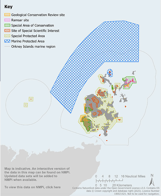
Map 7 International and national nature conservation sites: Map is indicative. An interactive version of the data in this map can be found on NMPi. Updated data sets will be added to NMPi when available.
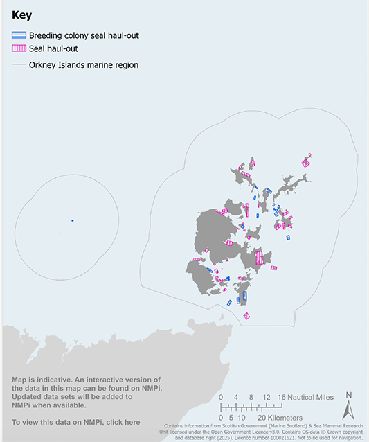
Map 8 Designated seal haul out sites: Map is indicative. An interactive version of the data in this map can be found on NMPi. Updated data sets will be added to NMPi when available.
General Policy 10: Seascape and Landscape
Policy intent
To protect and enhance the distinctiveness and qualities of seascape and landscape.
Context
2.76 Orkney’s coastline contains outstanding seascape and landscape, ranging from shallow sandy bays to dramatic high cliffs, to partially enclosed sounds, reflecting a strong physical and visual interplay between land and sea (see Map 9). This is well represented among the many Special Qualities of the Hoy and West Mainland National Scenic Area (see Map 10), in particular its ‘spectacular coastal scenery’ and the fact that ‘land and water [are experienced] in constantly changing combinations under the open sky’[63].
2.77 Each island in Orkney has its own seascape and landscape character, which creates variety and contributes to both an individual and a collective sense of identity, as outlined in the Coastal Character Assessment – Orkney and North Caithness[64].
2.78 The distinctiveness of Orkney’s islands and waters creates a corresponding variety of seascapes and landscapes worthy of protection. Not only are they part of the spectacular scenery, they also contribute significantly to a sense of place, wellbeing and quality of life, as well as being a major economic asset for Orkney.
2.79 Marine and coastal development and activities, for example offshore wind, harbours and aquaculture, can have significant effects on the character and qualities of Orkney’s landscape and seascape. General Policy 10 aims to help decision makers and developers manage impacts on seascapes and landscapes, safeguard the integrity of National Scenic Areas and appropriately managing impacts on Wild Land Areas.
General Policy 10 : Seascape and Landscape
General Policy 10a: Seascape and landscape
Development and/or activities should be located, sited and designed to avoid, minimise and/or appropriately mitigate significant adverse impacts on the landscape, townscape and seascape characteristics and sensitivities identified in the Orkney and North Caithness Landscape Character Assessment*, and should have regard to the natural and/or historic features that contribute to the quality of seascape and landscape.
*Coastal Character Assessment - Orkney and North Caithness | NatureScot
General Policy 10b: National Scenic Area
Development and/or activities that would affect the Hoy and West Mainland National Scenic Area should demonstrate that:
i. the objectives of the designation and the overall integrity of the area will not be compromised; or
ii. any significant adverse effects on the qualities for which the area has been designated are clearly outweighed by social, environmental or economic benefits of national importance.
General Policy 10c: Wild Land Area
Development and/or activities affecting the Hoy Wild Land Area should have regard to the National Planning Framework.
Table 13: General Policy 10 links to Plan objectives, State of the Environment Assessment and other plans
Contribution to Regional Marine Plan objectives
Direct contribution to objectives – 2, and 6.
Indirect contribution to objectives – 5, and 8.
Assessment of the condition of the Orkney Islands marine region
Orkney Islands Marine Region: State of the Environment Assessment baseline information – Section 2.8.
Alignment with other marine and land-use plans
National Marine Plan 2015 – GEN 7.
National Planning Framework 4 – Policy 4.
Orkney’s Regional Spatial Strategy (Indicative) – Strategic Priority: An Outstanding Environment and Quality of Life.
Orkney Local Development Plan 2017 – Policy 9G.
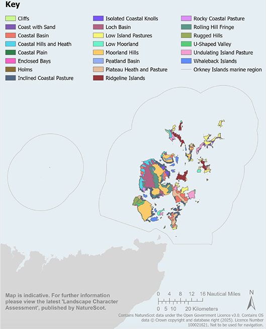
Map 9 Landscape character types: Map is indicative. For further information please view the latest ‘Landscape Character Assessment’, published by NatureScot. Map 9 is not currently available on NMPi.
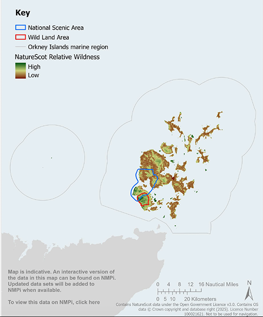
Map 10 National Scenic Area and Wild Land Area: Map is indicative. An interactive version of the data in this map can be found on NMPi. Updated data sets will be added to NMPi when available.
General Policy 11: Surface and Underwater Noise, and Vibration
Policy intent
To protect local communities and marine species from adverse noise and vibration impacts.
Context
2.80 Coastal and marine development and activities can have associated noise, vibration and pressure wave impacts. As the number and variety of marine developments, activities and uses increases, addressing the cumulative impacts of anthropogenic noise and vibration will be a significant issue for marine planning and decision making.
Local communities
2.81 Construction and operational noise and/or vibration, both surface and underwater, caused by development, activities, or use, can impact on local communities. For example, surface fish farm electricity generators or harbour piling activity can affect the enjoyment of an area by residents or people wishing to walk, swim or dive. Planning Advice Note (PAN) 1/2011 provides guidance on how the planning system helps to prevent and limit the adverse effects of noise[65].
Noise sensitive species
2.82 Surface and underwater noise and vibration is a growing pressure for many marine species worldwide. For example, blasting, drilling, piling, and acoustic devices, used in marine development and activities can disturb a variety of marine and coastal species.
2.83 European Protected Species, such as porpoise and orca, and Priority Marine Features, such as mackerel and flapper skate, are sensitive to underwater noise, as are seals. In addition, fish and invertebrates of biodiversity and commercial importance can also be affected by underwater noise[66][67]. Impacts vary with different frequencies and depending on the nature and duration of the activity[68].
2.84 Around Orkney’s marine waters, there has been little comprehensive study of the quantity and levels of underwater noise; this was identified as a data gap in the Orkney Islands Marine Region: State of the Environment Assessment. As new research and information becomes available, General Policy 11 will be updated to reflect this.
2.85 Due to Orkney’s extensive military past, old munitions are still occasionally found; these tend to be dealt with by way of controlled explosion on safety grounds. There is a Marine environment: unexploded ordnance (UxO) clearance Joint Position Statement[69]. This position statement sets out how the UK Government and devolved nations expect potential applicants to approach marine licensing for these activities and provides guidance on how best to undertake applications for UxO clearance activities.
General Policy 11: Surface and Underwater Noise, and Vibration
General Policy 11a: Local communities
i. Proposals for development and/or activities should include sufficient measures to avoid, minimise and/or appropriately mitigate significant adverse noise and/or vibration impacts on the local communities; and
ii. A Noise Impact Assessment* may be required where the nature of the proposal or its location suggests that significant effects are likely.
*Assessment of noise: technical advice note: Scottish Government
General Policy 11b: Noise sensitive species
i. Proposals for development and/or activities that could cause noise, vibration and/or pressure wave impacts should include an assessment of the likely noise, vibration and/or pressure wave effects at an early stage of a proposal, to determine whether a noise, vibration and/or pressure wave management plan is required.
ii. Proposals for development and/or activities that could affect European Protected Species must comply with the relevant legislation.
Table 14: General Policy 11 links to Plan objectives, State of the Environment Assessment and other plans
Contribution to Regional Marine Plan objectives
Direct contribution to objectives – 2, and 6.
Indirect contribution to objectives – 10.
Assessment of the condition of the Orkney Islands marine region
Orkney Islands Marine Region: State of the Environment Assessment baseline information – Section 2.12.
Alignment with other marine and land-use plans
National Marine Plan 2015 – GEN 13.
National Planning Framework 4 – Policies 11 e), 12 d) and 23 e).
Orkney’s Regional Spatial Strategy (Indicative) – Strategic Priority: An Outstanding Environment and Quality of Life.
Orkney Local Development Plan 2017 – N/A.
General Policy 12: Marine Litter and Waste
Policy intent
To encourage, promote and facilitate sustainable waste management and the prevention and removal of coastal and marine litter.
Context
2.86 Public understanding of the impacts of marine litter has grown exponentially over recent years. The problem is mainly caused by a range of persistent, slowly degrading materials such as plastics, microplastics, metals and glass, which can circulate across great distances. In the Orkney Islands marine region and around the world, by far the most commonly found litter at sea and washed ashore is plastic,[70], [71] which forms around 75% of all marine debris globally[72] (see Map 11).
2.87 Litter poses a threat to a wide range of wildlife in the form of ingestion, entanglement and smothering, which already results in the deaths of hundreds of thousands of seabirds and marine mammals globally each year,[73] including species in Orkney[74]. Marine debris can also pose a navigational hazard, is unsightly, and is an economic burden on affected communities. Most plastic debris found in the ocean enters via land-based sources, with tributaries and burns transporting litter from further inland to the marine environment[75]. However, in Orkney, there is no clear evidence on the sources of marine litter.
2.88 Marine Directorate of the Scottish Government published an updated Marine Litter Strategy in 2022[76] as part of its overall approach to marine planning and management. The National Litter and Flytipping Strategy sets out a refreshed approach to tackling litter and flytipping in order to protect and enhance Scotland’s environment[77]. In support of the Scottish Government’s commitment to reduce marine litter, General Policy 12 aims to put in place measures to avoid and minimise the risk of development and activities contributing to marine litter in the Orkney Islands marine region. Implementing waste management measures and the waste reduction hierarchy[78] will help to generate less waste and ensure that waste is disposed of in ways that do not harm the marine environment. Public authorities are also encouraged to proactively engage in local litter reduction and monitoring schemes, including appropriate involvement in community organised events such as Orkney’s ‘Bag the Bruck’. The Orkney Harbour Authority participate in the Fishing For Litter scheme, which provides free waste disposal facilities for fishers to dispose of litter collected during fishing[79].
2.89 Marine waste refers to waste streams generated from marine development and activities, which require licensed disposal.
2.90 Many wider initiatives to address marine litter and waste in Orkney are being addressed through other measures, strategies and management plans, and users of this Plan should consider these accordingly. These include but are not limited to:
- The International Convention for the Prevention of Pollution from Ships (MARPOL)[80], which strictly prohibits the discharge of all litter into the sea.
- The Port Waste Management Plan operated by Orkney Islands Council Marine Services[81], which ensures that all ship-generated waste and cargo residue is controlled at all of the authority’s piers and harbours.
General Policy 12: Marine Litter and Waste
i. Proposals for development and/or activities that are likely to create a significant risk of contributing to marine litter should include measures to avoid, minimise and/or appropriately mitigate these risks.
ii. Where appropriate, proposals for development and/or activities should consider including a waste minimisation and management plan that sets out appropriate waste management measures for construction, operation and decommissioning phases, in accordance with the principles of the waste reduction hierarchy.
iii. Where appropriate, waste generated by development and/or activities should be disposed of through licensed facilities.
iv. When exercising functions capable of affecting the Orkney Islands marine region, public authorities should take reasonable and proportionate measures to avoid, minimise and/or appropriately mitigate the risk of contributing to coastal and marine litter and, where appropriate, implement the waste reduction hierarchy.
Table 15: General Policy 12 links to Plan objectives, State of the Environment Assessment and other plans
Contribution to Regional Marine Plan objectives
Direct contribution to objectives – 6.
Indirect contribution to objectives – 2.
Assessment of the condition of the Orkney Islands marine region
Orkney Islands Marine Region: State of the Environment Assessment baseline information – Section 1.17.
Alignment with other marine and land-use plans
National Marine Plan 2015 – GEN 11.
National Planning Framework 4 – Policy 12.
Orkney’s Regional Spatial Strategy (Indicative) – Strategic Priority: An Outstanding Environment and Quality of Life.
Orkney Local Development Plan 2017 – Policy 1 viii.
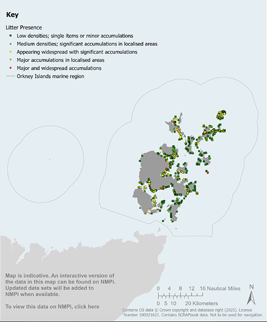
Map 11 SCRAPBook coastal litter survey: Map is indicative. An interactive version of the data in this map can be found on NMPi. Updated data sets will be added to NMPi when available.
General Policy 13: Non-native and Invasive Non-native Species
Policy Intent
To minimise the risk posed by non-native and invasive non-native species and associated effects on the marine environment and economy.
Context
2.91 Non-native species (NNS) are those that have been intentionally or unintentionally introduced outside their native range as a consequence of human activity. Once established, if these species then threaten biodiversity and/or cause economic damage, they are referred to as ‘invasive’ non-native species (INNS). Impacts of INNS include, but are not limited to, competition with native species over resources, changes to habitat and/or water quality, and transmission of disease. All these factors can be exacerbated by climate change.
2.92 The Great Britain Invasive Non-Native Species Strategy[82] provides an overarching framework to minimise the risk posed by INNS in Great Britain and reduce their negative impacts. The first principle in tackling this issue is prevention. The Scottish Government’s Non-Native Species: Code of Practice[83], and the references contained therein, provides guidance on the various control orders and agreements that may be required, including information on pathways for the potential spread of INNS.
2.93 Locally, the Ballast Water Management Policy for Scapa Flow (2017)[84] sets out a management strategy to address the introduction and spread of INNS, which will be instrumental in mitigating the impact of, and adapting to, any non-native species discovery in local marine waters around the key harbour areas.
2.94 Pathways for the introduction and spread of INNS include renewable energy and aquaculture development, shipping and marine litter. Good biosecurity practice should consider the risk of planned development and activities establishing new pathways for the spread of INNS[85]. The Clean Check Dry campaign is broadly applicable for a range of water users as an additional biosecurity measure[86].
2.95 Invasive non-native stoats pose a significant threat to Orkney’s native coastal wildlife communities, many of which are already under threat. As stoats are excellent swimmers and can cross open sea to a distance of 3km, they put seabird populations of national importance, such as puffin, Arctic tern and red-throated diver, at risk on currently stoat-free islands. The Orkney Native Wildlife Project[87] is working to safeguard native wildlife through the eradication of stoats from the islands and will prepare a biosecurity plan to safeguard Orkney’s native wildlife into the future.
General Policy 13: Non-native and Invasive Non-native Species
i. Proposals for development and/or activities should demonstrate that the potential risks of introducing or spreading NNS/INNS have been adequately considered, having regard to the NatureScot Marine Biosecurity Planning Guidance*. A site-specific biosecurity plan may be required.
ii. Appropriate prevention measures should be put in place when:
a. moving, maintaining and cleaning equipment or boats;
b. moving and/or introducing fish and shellfish and other farmed species such as seaweed;
c. introducing structures suitable for settlement of aquatic NNS/INNS or which facilitate the movement of terrestrial NNS/INNS, including to islands; or
d. undertaking habitat enhancement or restoration activities.
iii. Proposals for development and/or activities in areas where NNS/INNS are known to exist should include necessary measures or a biosecurity plan approved by the consenting authority or regulator that seeks to minimise the risk of spreading the NNS/INNS or identifies ways to eradicate the organisms and prevent their reintroduction. Where appropriate, measures within a biosecurity plan should include surveying and ongoing monitoring in areas where NNS/INNS are known to exist, and any subsequent spread of NNS/INNS should be notified to the Marine Directorate.
* NatureScot Marine Biosecurity Planning Guidance
Table 16: General Policy 13 links to Plan objectives, State of the Environment Assessment and other plans
Contribution to Regional Marine Plan objectives
Direct contribution to objectives – 2.
Indirect contribution to objectives – 4.
Assessment of the condition of the Orkney Islands marine region
Orkney Islands Marine Region: State of the Environment Assessment baseline information – Section 5.8.
Alignment with other marine and land-use plans
National Marine Plan 2015 – GEN 10.
National Planning Framework 4 – N/A.
Orkney’s Regional Spatial Strategy (Indicative) – Strategic Priority: An Outstanding Environment and Quality of Life; Strategic Priority: Thriving Economy
Orkney Local Development Plan 2017 – Section 13.5.
General Policy 14: Amenity, Wellbeing and Quality of Life of Local Communities
Policy Intent
To protect and enhance the amenity, wellbeing and quality of life of local communities.
Context
2.96 Sustainable economic development in island communities can deliver many socio-economic benefits improving community wellbeing and quality of life. Orkney is valued by local communities as a unique and special place to live and work. There are many factors that contribute to the quality and enjoyment of a place and the resulting sense of community wellbeing. Studies of marine spatial planning processes[88] have shown that capturing wider values, including cultural values linked to, for example family and village history, together with the biodiversity qualities of a region, is of vital importance to coastal communities. General Policy 14 aims to ensure that consideration is given to safeguarding the amenity, wellbeing and quality of life of local communities. During the lifetime of this Plan, Orkney Islands Marine Region: Amenity, Wellbeing and Quality of Life Guidance may be adopted to help guide the implementation of this policy.
2.97 The Town and Country Planning (Scotland) Act 1997, as amended, identifies outcomes for planning including improving the health and wellbeing of people living in Scotland. Building a Wellbeing Economy is now a national policy priority in Scotland[89] and is core to the National Strategy for Economic Transformation[90].
2.98 General Policy 14 supports a place-based approach to planning, development and community engagement[91]. A place-based approach is about understanding the potential of a place and coordinating action to improve outcomes, with community participation at the heart of the process. It is about understanding the issues, interconnections and relationships in a place and coordinating action and investment to improve the quality of life for that community.
2.99 Amenity, in planning terms, refers to the positive elements that contribute to the overall character and/or enjoyment of an area by residents, visitors and other users.
2.100 Identifying the factors that contribute to the amenity, wellbeing and quality of life of local communities is essential, but challenging, to address in marine planning policy and decision making, particularly doing so in a way that can integrate place-based perspectives linked to local knowledge[92]. It is therefore important to engage effectively with local communities when preparing proposals for development and activities that could have significant effects, both beneficial and adverse, on their amenity, wellbeing and quality of life. This engagement can help to identify relevant factors that contribute towards the amenity, wellbeing and quality of life of local communities, and how these factors can be affected by development or activity proposals.
2.101 Marine and coastal recreation can contribute not only to human health and wellbeing, but also significantly to the economy[93]. Thus, the quality of the marine environment and its natural capital links directly to the socio-economic benefits provided to society[94].
General Policy 14: Amenity, Wellbeing and Quality of Life of Local Communities
General Policy 14a: Engaging local communities
i. Proposals for development and/or activities should demonstrate that local community stakeholders have been appropriately engaged, and listened to, at an early stage in the development process when assessing impacts on the amenity, well-being and quality of life of local communities and, where appropriate, opportunities for enhancement measures.
ii. Co-creation, with local community stakeholders, of appropriate mitigation to address impacts on amenity, wellbeing and quality of life of local communities is encouraged, and where appropriate, measures to enhance the wellbeing and quality of life of local communities are encouraged.
General Policy 14b: Delivering benefits for places and local communities
Proposals for development and/or activities should:
i. maximise opportunities to deliver amenity, wellbeing and quality of life benefits for local communities, where possible.
ii. demonstrate that regard has been given to the Six Qualities of Successful Places*, where applicable.
General Policy 14c: Amenity
Proposals for development and/or activities should:
i. avoid, minimise and/or appropriately mitigate, significant adverse effects on amenity due to factors including, but not limited to, waste, noise, air quality, light and odour; and
ii. be designed to a high standard and quality, so that the nature and scale of the development and/or activities contribute positively to the character and sense of place of the area in which they are proposed to be located.
General Policy 14d: Amenity, wellbeing and quality of life of local communities guidance
Proposals for development and/or activities should have regard to the Orkney Islands Marine Region: Amenity, Wellbeing and Quality of Life Guidance, where available.
*National Planning Framework 4: Annex D – Six Qualities of Successful Places
Table 17: General Policy 14 links to Plan objectives, State of the Environment Assessment and other plans
Contribution to Regional Marine Plan objectives
Direct contribution to objectives – 5, 6, and 10.
Indirect contribution to objectives – 2, and 4.
Assessment of the condition of the Orkney Islands marine region
Orkney Islands Marine Region: State of the Environment Assessment baseline information – Section 7.
Alignment with other marine and land-use plans
National Marine Plan 2015 – Policy Rec & Tourism 5.
National Planning Framework 4 – Policy 14.
Orkney’s Regional Spatial Strategy (Indicative) – Strategic Priority: An Outstanding Environment and Quality of Life.
Orkney Local Development Plan 2017 – Policy 12A.