Orkney Islands Regional Marine Plan
This plan covers the management of the Scottish Marine Region for the Orkney Islands. It guides and supports decision making for development and use of the sea, and represents the second tier of marine planning, following on from the National plan.
Section 1: Introduction
Purpose of the Orkney Islands Regional Marine Plan
1.1 The Orkney Islands Regional Marine Plan (‘the/this Plan’) has been prepared to guide decision making that will contribute to the achievement of sustainable development, activities and use in the Orkney Islands marine region (Refer to Map 1).
1.2 The Marine (Scotland) Act 2010 requires a regional marine plan to state the Scottish Ministers’ policies for and in connection with the sustainable development of the area to which the plan applies and on the contribution of Nature Conservation Marine Protected Areas (MPA), and other relevant conservation sites, to the protection and enhancement of that area. The Plan is a regional marine plan prepared and adopted in accordance with this statutory purpose.
1.3 The Plan has been prepared by Orkney Islands Council as a single delegate, in accordance with the Delegation of Functions (Regional Marine Plan for the Scottish Marine Region for the Orkney Islands) Direction 2020. It has been prepared in conformity with the UK Marine Policy Statement 2011 and the National Marine Plan 2015. Steps have been taken to ensure that the Plan is compatible with the development plan which includes the National Planning Framework 4 (NPF4) and the Orkney Local Development Plan 2017.
1.4 The Orkney Marine Planning Advisory Group has provided expert input on environmental, social, economic and recreation matters to inform the preparation of the Plan[1].
How to use the Plan policy framework
1.5 Marine planning and associated decision making requires careful balancing of considerations. This Plan contains policies to guide public authorities, including but not limited to, decision makers, consenting authorities, regulators, and planners, to make decisions on sustainable development and activities (see the definition of these terms in Table 1 and Appendix 7) within, or that affect, the Orkney Islands marine region (see Map 1).
1.6 Public authorities are required by the Marine (Scotland) Act 2010 to take authorisation or enforcement decisions in accordance with the appropriate marine plans, unless relevant considerations indicate otherwise. Public authorities are also required to have regard to the appropriate marine plans in making any other decision which relates to the exercise by them of any function capable of affecting the whole or any part of the Scottish marine area[2]. For these purposes, the appropriate marine plans are any national marine plan which is in effect, and for decisions that relate to a Scottish marine region, any regional marine plan which is in effect for the region.
1.7 The Plan policies included are to guide public authority decision makers to contribute towards the delivery of the Plan objectives. The Plan policies aim to guide relevant decision making. It is for the relevant public authority decision maker to determine which policy, policies, or component of a policy, are relevant to a specific decision and what weight to attach to policies on a case-by-case basis.
1.8 The Scottish Government, through its Marine Directorate, is responsible for fisheries management within the Orkney Islands marine region. As fisheries management is taken forward through other dedicated processes, the development of new management measures falls outside the scope of this Plan. As such, this Plan has been prepared without policies that directly aim to address further management of fisheries.
1.9 The Plan policies should be applied proportionately by public authority decision makers. The Plan policies should not be considered or applied in isolation, they should be read as a whole. Decision makers need to consider whether the type, location and/or scale of a development or activity, and its associated impacts or effects, justify the application of a specific policy or a provision within a policy. If to any extent a policy stated in this Plan conflicts with any other statement or information in the Plan, that conflict must be resolved in favour of the policy. Where there is the potential for conflicts to arise between Plan policies, decisions should be made on a case-by-case basis to best support the delivery of the objectives of this Plan.
1.10 The level of detail required to demonstrate compliance with Plan policies should be proportionate to a proposal’s scale and potential impacts, and in accordance with any relevant assessment requirements.
1.11 In accordance with the provisions of the Marine Licensing (Consultees) (Scotland) Order 2011[3], Orkney Islands Council, as the delegate, must be consulted in relation to any application for a marine licence for an activity which is to be carried out wholly or partly within the Orkney Islands marine region. This consultation process provides an opportunity for Orkney Islands Council to provide advice on Plan implementation.
1.12 Appendix 1, which is not exhaustive, identifies relevant licence and consent regimes administered by public authorities to manage development and activities in the Orkney Islands marine region. These decision-making regimes are the primary mechanism for implementing the Plan’s objectives and policies.
1.13 The Plan is structured into four sections:
1. Introduction;
2. General Policies;
3. Sector Policies; and
4. Monitoring, Evaluation and Review.
1.14 These sections are supported by appendices that provide further information to assist Plan users.
1.15 The Plan’s policy framework consists of a suite of general policies and a suite of sector policies. These policies express intent and guide decisions to achieve the Plan’s aim and objectives (see Table 2).
1.16 All of the Plan policies should be considered alongside the relevant legislation, policies and plans; key documents are outlined in Appendix 2, which is not exhaustive.
1.17 To enable the general and sector policies to be interpreted and implemented by decision makers, and clearly understood by other Plan users, Table 1 provides definitions of the key policy terms. Appendix 7 provides definitions of terms referred to in this Plan, along with a list of acronyms used.
Table 1: Definition of key policy terms used in this Plan*
Term – Definition
Activity/activities – Any activity/activities that require authorisation from a public authority and falls within devolved competencies, e.g. ‘licensable marine activities’ identified under the Marine (Scotland) Act 2010 and activities licensed under the Water Environment (Controlled Activities) (Scotland) Regulations 2011.
Authorisation or enforcement decision – The determination of any authorisation or any decision relating to enforcement as detailed and further expanded upon in the Marine (Scotland) Act 2010, section 15 [4]. Appendix 1, which is not exhaustive, contains relevant licensing and consent regimes, and associated processes, administered by public authorities to manage marine development and activities.
Development – Any construction, building, engineering, mining, other operation and/or works, e.g. planning permission or a works licence, that require authorisation from a public authority under devolved competencies. This can include new development, or alterations, extensions or changes in material use to existing development or land.
Use – Any legitimate use of the marine and/or coastal environment that is exercised under a public right and that does not require authorisation from a public authority, e.g. freedom of navigation for shipping or the exercise of public access rights for the purposes of recreation.
Marine and/or coastal user(s) – Legitimate users of the marine and/or coastal environment for purposes such as, but not limited to, fishing, aquaculture, shipping, transport, energy generation, utilities, recreation and other economic and/or community activities.
*see Appendix 7 for a glossary.
Impacts or effects from development and activities
1.18 The Plan policies aim to maximise positive impacts or effects from development and activities and appropriately manage adverse impacts or effects. The impacts or effects of marine development and activities are not limited to the site boundaries of a proposal; for example, sediment plumes arising from dredging activity can be transported to surrounding areas before settling on the seabed. Impacts or effects can be temporary, permanent, direct, indirect, short term, medium term, long term and/or cumulative.
1.19 It is important to consider the cumulative impact of development and/or activities on the marine environment, economic receptors and infrastructure. Proposals for development and/or activities should consider cumulative impacts associated with relevant existing and proposed development and/or activities, not just those of the same type or sector. Where required, cumulative impacts or effects should be assessed in accordance with the requirements of the appropriate Environmental Impact Assessment (EIA) regulations.
1.20 The determination of what is a significant impact or effect should be made by the appropriate public authority decision maker. This judgement should be informed by relevant information and data, assessment, and the views of statutory consultees and wider stakeholders.
1.21 Impact or effect significance can be appraised by considering factors including the nature, size and location of the proposal, the potential pathways to impact, potential for cumulative impacts or effects, the significance and sensitivity of affected receptors (e.g. an environmental feature or infrastructure asset), and the magnitude of the impact or effect.
1.22 An overarching aim of the Plan’s general and sector policies is to, in order of preference, avoid, minimise and/or appropriately mitigate any significant adverse impacts or effects that could be caused by proposed development and/or activities. This should be achieved by implementing the mitigation hierarchy (see Appendix 7a). The most effective mitigation measures are those which avoid or prevent the creation of adverse impacts or effects at source, and such measures should be identified during the project planning and design stage e.g. avoiding sites with potential to have significant adverse impacts on sensitive receptors. The aim of this approach is to prevent or avoid the adverse impacts or effects, if possible, and only then consider other mitigation measures. Where specific mitigation measures are required, these can be secured as part of the relevant consent and/or permission.
1.23 In addition to supporting the identification of appropriate mitigation measures, the Plan policies aim to support the delivery of environmental, social and economic benefits, enhancement and positive effects for biodiversity.
Vision, guiding principles, aim and objectives
1.24 Orkney’s coastal and marine environment needs to be carefully managed to ensure it is clean, healthy, safe and productive, now and for future generations. This Plan aims to enable sustainable marine development, activities, and use in Orkney, whilst protecting, and where appropriate enhancing, the environment and associated ecosystems on which these undertakings, and local communities, depend.
1.25 Regional marine plans must set economic, social and marine ecosystem objectives, and objectives relating to mitigation of, and adaptation to, climate change.
1.26 The Plan’s vision, guiding principles, aim and objectives are presented in Table 2. The vision statement declares the goal that is intended to be achieved looking forward to 2045. The vision will be achieved by implementing the Plan’s aim and objectives, and associated policies, and monitoring and evaluating their effectiveness. The Plan policies implement the aim and objectives. Each of the Plan policies is supported by a table that identifies the objectives to which the policy contributes. Appendices 4 and 7 provide further information on the terms outlined in Table 2.
Table 2: Vision, guiding principles, aim and objectives of the Orkney Islands Regional Marine Plan
Vision – looking forward to 2045
The Orkney Islands marine region is clean, healthy, safe and productive; Orkney’s marine and coastal environment is rich in biodiversity and managed sustainably to support thriving and resilient local communities.
Guiding principles
The Orkney Islands Regional Marine Plan has been developed in accordance with five guiding principles adopted to help steer the plan-making process, strategy and policies.
A – Sustainable development, activities and use
Sustainable development, activities, and use are enabled whilst protecting the environment; ensuring a strong, safe, healthy and just society; achieving a sustainable economy; promoting good governance; using sound science responsibly; and supporting the delivery of the United Nations (UN) Sustainable Development Goals[5].
B – Ecosystem approach
An ecosystem approach is used to manage the marine environment and enable climate change mitigation, as well as adaptation to the predicted effects of climate change, in response to the twin global climate and nature crises.
C – Coexistence
Coexistence between marine development, activities, and use is supported to minimise potential conflict and maximise synergistic benefits.
D – Partnership working and stakeholder participation
This Plan is developed through an inclusive process of partnership working and stakeholder participation.
E – Integrated approach to marine and land-use planning
Land and marine development and/or activities are planned in a joined-up way to address development and infrastructure requirements, and associated impacts, across the interface between land and sea.
Aim
Sustainable development, activities, and use of the marine and coastal environment of Orkney is supported, helping to tackle the twin climate and nature crises.
Sustainable development, activities, and use should maintain, and where appropriate enhance, biodiversity and ecosystem services; protect natural capital for future generations; and maximise social, economic and wellbeing benefits for local communities.
Objectives
1 – A clear strategic direction is provided for development, activities, and use in the Orkney Islands marine region and there is greater certainty for prospective developers, investors and local communities.
2 – Development, activities, and use are managed within an ecosystem approach, to protect and, where appropriate, enhance the biological, chemical and physical functioning of the marine and coastal environment, including the management of cumulative impacts.
3 – A rapid and just transition to a low-carbon economy is supported to achieve net-zero commitments.
4 – Mitigation of, and adaptation to, climate change is supported.
5 – Socio-economic benefits and prosperity are delivered for local communities and the wider economy.
6 – The well-being of local communities and the amenity of marine and coastal places are protected and enhanced.
7 – Reliable information is provided on existing and proposed coastal and marine development, activities, use and assets.
8 – Spatial planning and data are provided, enabling sustainable coexistence and synergies between existing and new marine development, activities, and use, and the environment.
9 – Plan users are assisted in navigating the relevant legislative and policy frameworks more easily and effectively.
10 – Local communities are effectively engaged in decisions affecting the Orkney Islands marine region.
Plan area
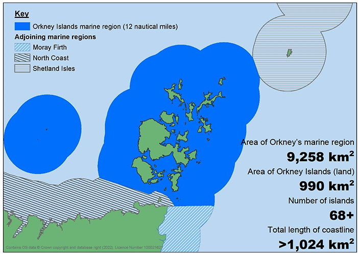
1.27 The Plan area is the Orkney Islands marine region (Map 1). This region extends from Mean High Water Springs (MHWS) out to the 12 nautical mile limit, which is an area of approximately 9,258 km2; this is nearly ten times the Orkney Islands land area. This Orkney Islands marine region includes Sule Skerry and Sule Stack with their separate 12 nautical mile boundary. The Orkney Islands marine region was established by the Scottish Marine Regions Order 2015[6].
Area of Orkney’s marine region
9,258 km2
Area of Orkney Islands (land)
990 km2
Number of islands
68+
Total length of coastline
>1,024 km2
Link to Map 1 Orkney Islands marine region area
Orkney Islands Marine Region: State of the Environment Assessment
1.28 To inform the preparation of this Plan, a baseline assessment was carried out, with key findings published in the Orkney Islands Marine Region: State of the Environment Assessment[7]. The assessment provides a snapshot of the physical, environmental, social and economic condition of the Orkney Islands marine region, including a summary of significant pressures and impacts from human activities, and the identification of relevant data gaps. In addition, Scotland’s Marine Assessment[8] provides an assessment of both the state of Scotland’s seas and the main activities and pressures in the various Scottish marine regions.
Spatial information and use of data
1.29 The Plan policies are supported by maps containing spatial information, which are presented alongside the relevant policy, where appropriate. In addition, the Plan’s maps and other spatial information can be accessed on Marine Directorate of the Scottish Government’s (Marine Directorate) National Marine Plan interactive (NMPi)[9]. Appendix 3 contains hyperlinks to display the map data within NMPi, where available. Data on NMPi is maintained by the data holder and may be updated or amended as required. Information on how to use NMPi is provided in Appendix 3.
1.30 The spatial information and relevant reference information presented within the Plan are intended to guide decision makers and applicants seeking permission or consent. This information represents the best available data at the point of publication.
1.31 Knowledge and understanding of the Orkney Islands marine region will develop over time. Therefore, when using the Plan, it is important that relevant available data, including within NMPi, is consulted to consider the most up-to-date spatial information.
1.32 As many of the issues and economic sectors addressed in this Plan are changing and evolving, new data, strategies and legislation will become available during the lifetime of the Plan. Whilst the most up-to-date information has been used to inform the plan-making process, data gaps and data redundancy are unavoidable. Users of this Plan should access the most up-to-date versions of any supporting data or documents referred to. The Plan will be reviewed in accordance with statutory requirements (see Section 4), and new relevant information will be made available on the Orkney Islands Council website.