Orkney Islands Regional Marine Plan
This plan covers the management of the Scottish Marine Region for the Orkney Islands. It guides and supports decision making for development and use of the sea, and represents the second tier of marine planning, following on from the National plan.
Appendix 3: National Marine Plan interactive
National Marine Plan interactive: User guide What is the National Marine Plan interactive?
A3.1 The NMPi is an online mapping tool developed by Marine Directorate of the Scottish Government to assist in the development and delivery of national and regional marine planning. It contains environmental, social and economic data for Scottish inshore waters (out to 12 nautical miles) and offshore waters (12–200 nautical miles).
A3.2 NMPi is not a static system, and data sets, new statistics and other details are added when available. Users of the Orkney Islands Regional Marine Plan are encouraged to refer to NMPi for up-to-date spatial data and maps.
A3.3 The full urls are provided to display the data contained with the policy maps on the NMPi, where available. Hyperlinks are also present within the maps. Please note that data on NMPi may be maintained by the data holder and differ from the maps within the Plan.
- Map 1 Orkney Islands marine region area
- Map 2 Health and Safety Executive Consultation Zones does not have publicly available data.
- Map 3 Waterbody classification: Water quality status
- Map 4 Wastewater treatment works available at the SEPA environmental data download page
- Map 5 Scottish Pollutant Release Inventory (SPRI) locations
- Map 6 Protected coastal and marine historic environment assets
- Map 7 International and national nature conservation sites
- Map 8 Designated seal haul out sites
- Map 9 Landscape character assessment is not currently available on NMPi
- Map 10 National Scenic Area and Wild Land Area
- Map 11 SCRAPBook coastal litter survey
- Map 12 Active aquaculture sites and disease management areas
- Map 13 Aquaculture water environment designations
- Map 14 Harbour areas, harbour infrastructure and ferry routes
- Map 15 Scapa Flow harbour infrastructure and operations
- Map 16 Anchorages
- Map 17 Dredge spoil deposit sites
- Map 18 Cables and pipelines
- Map 19 Offshore wind, wave and tidal energy sites
- Map 20 Oil and gas infrastructure
- Map 21 Recreational Anchorages, visiting yacht moorings and marinas
How do I access information on NMPi?
A3.4 NMPi is accessed online at http://maps.marine.gov.scot/ or via an internet search for ‘NMPi Scotland’. Data can be viewed via the ‘View layers to add/remove’ button.
A3.5 Layers can then be selected by navigating the folders or by searching for a keyword in the search bar (e.g. ‘MPAs’). To add the selected layers to the interactive map, select the layer(s) you wish to add and click the ‘Add/Remove Layers’ button.
A3.6 Tick the layers that you want to view in the ‘Layer Control’ window, and they will appear on the map. You can now zoom in to view the spatial information in more detail, view the origin of the data under the context menu (), or add more data layers by following the same process.
A3.6 The maps within this Plan contain hyperlinks to display the specific map data within NMPi where available. Data on NMPi is maintained by the data holder and may be updated or amended as required.
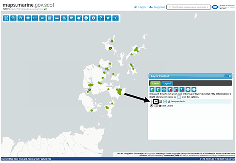
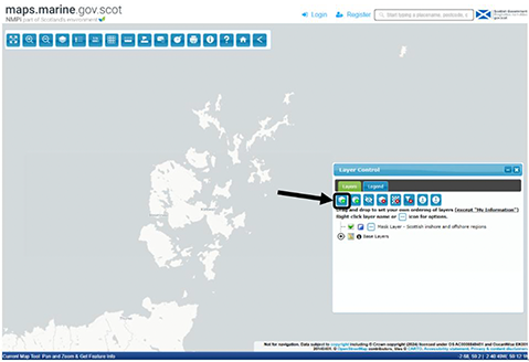
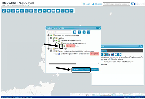
Example: Viewing seagrass locations
Step 1
Click ‘View layers to add/remove’.
Step 2
Navigate the layer folders or search with a keyword in the search bar (e.g. ‘Seagrass’). Tick the layers you would like to add and click ‘Add/Remove Layers’.
Step 3
Tick the layers you would like to view and they will be added to the map.