Orkney Islands Regional Marine Plan
This plan covers the management of the Scottish Marine Region for the Orkney Islands. It guides and supports decision making for development and use of the sea, and represents the second tier of marine planning, following on from the National plan.
Section 3: Sector Policies
Introduction
3.1 Sector policies are relevant to the determination of authorisation or enforcement decisions for a particular type of development or activity, for example fish farming or renewable energy generation. The sector policies provide a policy framework to assist public authorities, including regulators, decision makers and planners, to make decisions on sustainable development and activities that take place within, or that affect, the Orkney Islands marine region. Having a suite of sector policies helps ensure that the Plan contributes to government priorities and local sustainable development objectives.
3.2 As stated in General Policy 1, there is a presumption in favour of sustainable development, activities and use of the marine environment, when it is consistent with the policies and objectives of this Plan. This approach aligns with Scotland’s National Marine Plan. It should also help to deliver sustainable economic development by providing greater certainty to businesses and investors utilising marine space and resources in the Orkney Islands marine region.
3.3 The sector policies identify, by economic sector, the relevant environmental, social and economic factors that should be considered by decision makers and applicants. Development and/or activity proposals should give consideration to their potential impacts on existing marine users, developments and activities. Where relevant, the sector policies identify how such potential impacts should be addressed e.g. Sector Policy 1: Commercial fishing identifies the requirements for assessing impacts from other development and/or activity types on commercial fishing opportunities. Some development types, for example an offshore windfarm, will have to consider several sector policies: the renewable energy, cables, harbours and commercial fisheries policies, for example. Therefore, proposals for development and/or activities should have regard to all the relevant sector policies.
3.4 The sector policies can help to guide applicants preparing proposals for development and activities.
3.5 Section 1 provides relevant information on how to use the Plan’s policy framework.
3.6 General policies are contained in Section 2 of the Plan.
Policy structure
3.7 Each policy has an introductory section detailing the intent and context for the policy, including key information about the economic sector that is particularly relevant to Orkney. The policy is then presented in a clearly defined policy box. The associated text for each policy includes supporting information that should be taken into account in relevant decision making.
3.8 Each policy is supported by an information box that outlines:
- the contribution of the policy to the Plan objectives;
- relevant information in the Orkney Islands Marine Region: State of the Environment Assessment; and
- the policy’s alignment with other key marine and land-use plans.
3.9 Where appropriate, the Plan policies are supported by spatial information in map form or reference to other relevant spatial information (see Section 1 for details on the use of spatial information and data).
3.10 Appendix 1, which is not exhaustive, identifies relevant licence and consent regimes administered by public authorities to manage development and activities in the Orkney Islands marine region. These decision-making regimes are the primary mechanism for implementing the Plan’s objectives and policies.
3.11 A summary of the wider relevant legislation, policies and guidance that should be considered alongside this Plan is provided in Appendix 2, which is not exhaustive.
Sector Policy 1: Commercial Fishing
Policy IntentTo support and enable a thriving and sustainable commercial fishing sector.
Context3.12 Commercial fishing makes a significant contribution towards national food security and to the economy of Orkney. It is an important source of income, particularly in the more remote and fragile island communities[95]. Additionally, fishing is culturally and historically significant to Orkney communities and is closely tied to community identity and quality of life.
3.13 In the Orkney Islands marine region, commercial fishing is predominately undertaken by inshore creel boats under 10 metres, fishing mainly brown crab. Dive boats, dredgers and jiggers also form part of the inshore fishing fleet[96]. Lobster, velvet and green crab, scallop, whelk and periwinkle are also important commercial shellfish species. Shoreside seafood processing makes a significant contribution to the Orkney economy.
3.14 The seas around Orkney support significant populations of commercially important species of finfish, with fishing targeting both demersal and pelagic stocks in the waters adjacent to Orkney. These fisheries rely on a healthy marine environment for productive nursery and spawning grounds. There is vessel monitoring system (VMS) and fishing intensity spatial data on National Marine Plan interactive, which shows the key areas used by vessels over 12 metres.
3.15 Scotland’s Fisheries Management Strategy sets out the Scottish Government’s approach to manage sea fisheries in Scotland in partnership with our stakeholders through ‘co-management’ and in a way that balances environmental, social, and economic interests[97]. An Inshore Fisheries Management Improvement (IFMI) Programme of work is also underway to develop more agile and responsive inshore fisheries management in Scotland. A call for evidence for the new framework was recently published and consultation is planned for Q1 2026[98].
3.16 The Orkney Regional Inshore Fisheries Group (ORIFG) aims to improve the management of inshore fisheries, in the Orkney territorial waters (0–12 nautical mile zone) and to give commercial inshore fishermen a strong voice in wider marine management. The Scottish Government, through its Marine Directorate, is responsible for fisheries management within the Orkney Islands marine region. Fisheries Management Plans are being prepared as required under the Fisheries Act 2020 and the Joint Fisheries Statement[99]. The National Marine Plan states that Regional Inshore Fisheries Group (RIFGs) should work with all local stakeholders, including Marine Planning Partnerships, to agree joint fisheries management measures.
3.17 RIFGs currently have no powers to implement statutory fisheries management measures, though they are encouraged to implement voluntary measures that stem from their management plans. However, some measures require implementation by the Scottish Government through legislation.
3.18 The Orkney Fisheries Association (OFA) represents local members from inshore fishing vessels in the whitefish, nephrops, scallop and creel sectors, as well as processors and wholesalers.
3.19 Fishing has widespread impacts on the marine environment, affecting marine productivity and biodiversity. The degree of impact depends on the amount of fishing taking place, the efficiency and selectivity of gear, the approach taken to targeting species, and the nature and sensitivity of species and habitats affected. The degree of impact is also related to natural ecosystem dynamics. Commercial fisheries exert pressures on target and non-target fish populations, both directly through fishery removals, and indirectly by removing predators, prey, competitors and essential habitats[100].
3.20 Inshore commercial fishing in Orkney is predominately carried out from small locally owned vessels providing direct income for remote and economically fragile island communities. When assessing proposals for development and/or activities, regard should be given to the potential socio-economic impacts on the livelihoods of fishermen and associated fragile island communities (e.g. potential adverse effects on local services and exacerbating risks of depopulation).
3.21 Given its widespread nature, commercial fishing has the potential to interact significantly with a number of other economic sectors. Fishing activity in Orkney is year-round but follows seasonal trends, and given the dynamic and mobile nature of many fisheries, it is often very difficult to accurately predict precisely where activity will take place from year to year. Fishers will let grounds rest and rely on unfished nursery areas for a healthy fishery.
3.22 It can be beneficial when proposers of marine development or activities consult at an early stage with the ORIFG, OFA and affected fishers in the site-selection, design and planning process for their proposals. This early engagement can help to avoid, minimise and/or mitigate significant adverse impacts on commercial fishing opportunities, and impacts on nursery, spawning and feeding areas for commercially fished species.
Sector Policy 1: Commercial Fishing
i. Proposals for development and/or activities should avoid, minimise and/or appropriately mitigate significant adverse impacts:
a. on commercial fishing opportunities, taking into account seasonality and the year-round operation of the affected fishery;
b. on nursery, spawning and feeding areas for commercially fished species, and associated habitats and species;
c. due to displacement, including related impacts on the wider marine environment, on fish stocks and the use of fuel by fishing vessels;
d. on safe access to marine space for fishing vessels, including the seabed, water column and sea surface, and navigational access to and from landfall areas, e.g. ports, harbours or slipways; and
e. on the social and economic importance of fishing, in particular to fragile island communities.
ii. Proposals for development and/or activities should demonstrate appropriate consideration of the cultural importance of fishing in the area, and any impacts the proposal may have on this.
iii. Orkney Regional Inshore Fisheries Group, Orkney Fisheries Association and/or fishers that use an area that could be affected by a proposed development and/or activity should be consulted at an early stage in the site-selection, design and planning process.
Table 18: Sector Policy 1 links to Plan objectives, State of the Environment Assessment and other plans
Contribution to Regional Marine Plan objectives
Direct contribution to objectives – 9.
Indirect contribution to objectives – 5, and 10.
Assessment of the condition of the Orkney Islands marine region
Orkney Islands Marine Region: State of the Environment Assessment baseline information – Section 6.2.
Alignment with other marine and land-use plans
National Marine Plan 2015 – Chapter 6.
National Planning Framework 4 – N/A.
Orkney’s Regional Spatial Strategy (Indicative) – Strategic Priority: Sustainable Communities; Strategic Priority: Thriving Economy; Strategic Priority: An Outstanding Environment and Quality of Life
Orkney Local Development Plan 2017 – N/A.
Sector Policy 2: Aquaculture
Policy IntentTo support and enable a thriving and sustainable aquaculture sector.
ContextFinfish and shellfish farming3.23 Finfish and shellfish farming make an important contribution towards food production and food security in Scotland and the UK. The Vision for Sustainable Aquaculture describes the Scottish Government’s long-term aspirations to 2045 for the finfish, shellfish and seaweed farming sectors, and the wider aquaculture supply chain[101].
3.24 Salmon farming has been established in Orkney for many years, providing significant employment and wider socio-economic benefits to island communities[102]. Fish farming jobs and the economic value added to local supply chains support the sustainability of island communities, particularly in more remote and economically fragile locations.
3.25 Finfish and shellfish farming development and/or activities can have significant impacts on the marine environment; associated environmental pressures are identified in the Orkney Islands Marine Region: State of the Environment Assessment[103]. It is therefore important that these potential impacts and risks are carefully managed to safeguard the marine environment in Orkney. The degree of environmental impact depends on the type, scale, location and mitigation associated with a specific fish farming development or activity.
3.26 Marine fish farming, out to 12 nautical miles, requires planning permission under the Town and Country Planning (Scotland) Act 1997 ‘the 1997 Act’. Fish farming is defined in the 1997 Act, for purposes of development, as ‘the breeding, rearing or keeping of fish or shellfish (which includes any kind of sea urchin crustacean or mollusc)’. Marine fish farms may also require a marine licence (for equipment and moorings), an environmental licence (for farm discharges into the water environment), authorisation to operate as an Aquaculture Production Business, and a seabed lease from Crown Estate Scotland (CES).
3.27 There has been significant expansion of salmon farming development and activities in Orkney over recent decades, including new fish farms and increases in equipment size and production, and/or biomass, at existing fish farm sites (see Maps 12–13). This has increased the cumulative impacts on the marine environment and other marine users from these developments and activities. It is therefore important that the location, scale, siting and design of fish farm development and activities be appropriately managed to safeguard the marine environment and the interests of other marine users, with due consideration to cumulative impacts.
3.28 Orkney Islands Marine Region: Finfish Farming Spatial Guidance[104] should inform decision making on proposals for finfish farming development in Orkney. The guidance identifies the significance of environmental, historic, social, economic and infrastructure features, and the potential sensitivity of these features, or receptors, to finfish farming development and activities.
3.29 Scapa Flow Aquaculture Water Quality Impact Modelling Assessment – Development Management Guidance (2018)[105] provides a predictive far-field modelling assessment of current and proposed finfish fish farms in Scapa Flow. The assessment approach provides a better understanding of the water quality impacts of nutrient dispersion arising from existing and planned fish farms, including cumulative impacts.
3.30 The salmon farming industry is moving towards larger cages, higher biomass sites, and the siting of fish farms in higher energy locations to benefit from improved waste dispersal and to reduce adverse interactions with other marine users. It is anticipated that current technical innovation in the sector will enable finfish farm development in locations further offshore. These innovations have the potential to reduce future development pressure in more sensitive near-shore locations. There is also potential for the development of multitrophic, semi-closed and closed-containment aquaculture.
3.31 There are marine shellfish farming sites for Pacific oyster (Crassostrea gigas) cultivation in the Orkney Islands marine region.
3.32 During the lifetime of this Plan, Orkney Islands Marine Region: Shellfish Farming Spatial Guidance may be adopted to help guide the sustainable development of the sector in Orkney.
Seaweed cultivation3.33 Seaweed cultivation is not part of marine fish farming under the land-use planning system; the construction of a seaweed farm is a marine licensable activity requiring a marine licence. Proposals for a seaweed farm should align with the Marine Directorate Seaweed Cultivation Policy Statement 2017[106]. More detail on the various regulatory requirements and legislation are outlined in information available from the Seaweed Review Steering Group[107]. Appendix 6 provides information on wild seaweed harvesting.
3.34 Integrated sites (e.g. shellfish and seaweed) are supported by the Seaweed Cultivation Policy Statement 2017 and will require both planning permission and a marine licence to be obtained independently for each development or activity.
3.35 During the lifetime of this Plan, Orkney Islands Marine Region: Seaweed Cultivation Spatial Guidance may be adopted to help guide the sustainable development of the sector in Orkney.
Sector Policy 2: Aquaculture
Sector Policy 2a: Safeguarding the operation of active aquaculture sites
Proposals for development and/or activities should avoid, minimise and/or appropriately mitigate significant adverse impacts on the operation of active aquaculture sites.
Sector Policy 2b: Finfish and shellfish farming
i. Proposals for finfish and shellfish farming development and/or activities should have regard to:
a. The Orkney Local Development Plan;
b. The National Marine Plan;
c. The National Planning Framework; and
d. any Marine Directorate or SEPA licensing requirements and guidance.
ii. Proposals for finfish and shellfish farming development and/or activities should avoid, minimise and/or appropriately mitigate significant adverse impacts on:
a. landscape and/or seascape character and visual amenity;
b. nature conservation designations, protected species, and the wider biodiversity, including the national status of Priority Marine Features;
c. seal haul-out sites;
d. wild salmonid fish populations due to sea lice and/or escapes (applies to finfish farming only);
e. water quality, biological carrying capacity and the benthic environment;
f. historic environment assets;
g. other coastal and marine users including, but not limited to, commercial fishing, shipping and navigation, port and harbour infrastructure/operations, active aquaculture sites, marine cable routes and pipelines, tourism, recreation, and sport and leisure activities; and
h. amenity, including consideration of road traffic, noise, light, access, vibration, odour and litter impacts.
iii. Proposals for finfish and shellfish development and/or activities should ensure appropriate measures are included to prevent the introduction and spread of non-native species.
iv. New finfish farms should not bridge Disease Management Areas, although boundaries may be revised by the Marine Directorate to take account of any changes in fish farm location, subject to the continued management of risk.
v. Appropriate planning conditions and, where necessary, a financial bond or a letter of credit will be concluded to ensure that decommissioning and site restoration arrangements will be implemented following cessation of the operation.
vi. Proposals for finfish farming development should have regard to the Orkney Islands Marine Region: Finfish Farming Spatial Guidance.
vii. Proposals for shellfish farming development should have regard to the Orkney Islands Marine Region: Shellfish Farming Spatial Guidance, where available.
Sector Policy 2c: Seaweed cultivation
i. Proposals for seaweed cultivation development and/or activities should demonstrate that:
a. regard has been given to the most up-to-date Scottish Government Seaweed Cultivation Policy Statement;
b. only seaweed species native to Orkney will be grown;
c. appropriate measures are included to prevent the introduction and spread of non-native species;
d. where seaweed is grown for human consumption, cultivators have sited farms at an appropriate distance from sewage outfalls and other potential sources of pollution; and
e. there will be no artificial enrichment of the marine environment to aid production.
ii. Proposals for seaweed cultivation development and/or activities should avoid, minimise and/or appropriately mitigate significant adverse impacts on:
a. landscape and/or seascape character and visual amenity;
b. nature conservation designations, protected species, and the wider biodiversity, including the national status of Priority Marine Features;
c. seal haul-out sites;
d. water quality and the benthic environment;
e. historic environment assets;
f. other coastal and marine users including, but not limited to, commercial fishing, shipping and navigation, port and harbour infrastructure/operations, active aquaculture sites, marine cable routes and pipelines, tourism, recreation, and sport and leisure activities; and
g. amenity, including consideration of road traffic, noise, light, access, vibration, odour and litter impacts.
iii. Proposals for seaweed cultivation development and/or activities should have regard to the Orkney Islands Marine Region: Seaweed Cultivation Spatial Guidance, where available.
Table 19: Sector Policy 2 links to Plan objectives, State of the Environment Assessment and other plans
Contribution to Regional Marine Plan objectives
Direct contribution to objectives – 1, 7, 8, and 9.
Indirect contribution to objectives – 2.
Assessment of the condition of the Orkney Islands marine region
Orkney Islands Marine Region: State of the Environment Assessment baseline information – Section 6.3.
Alignment with other marine and land-use plans
National Marine Plan 2015 – Chapter 7.
National Planning Framework 4 – Policy 32.
Orkney’s Regional Spatial Strategy (Indicative) – Strategic Priority: Sustainable Communities; Strategic Priority: Thriving Economy; Strategic Priority: An Outstanding Environment and Quality of Life.
Orkney Local Development Plan 2017 – Policy 12D, Aquaculture Supplementary Guidance.
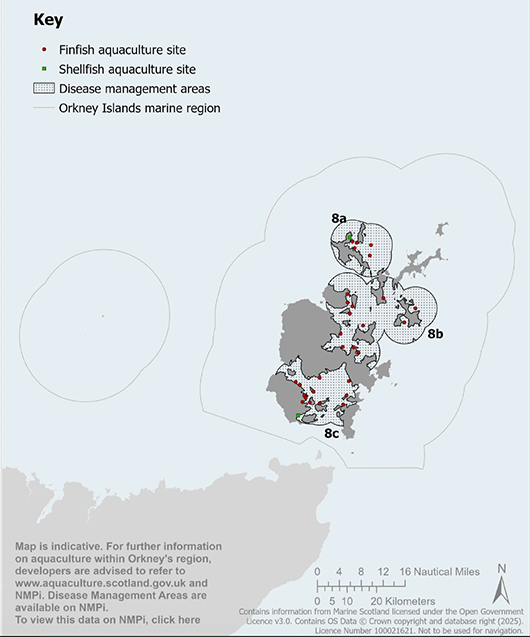
Map 12 Active aquaculture sites and disease management areas: Map is indicative. For further information on aquaculture within Orkney’s region, developers are advised to refer to the Scotland’s Aquaculture website and NMPi. Disease management areas are available on NMPi.
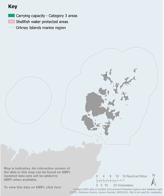
Map 13 Aquaculture water environment designations: Map is indicative. An interactive version of the data in this map ca be found on NMPi. Updated data sets will be added to NMPi when available.
Sector Policy 3: Shipping, Ports, Harbours and Ferries
Policy IntentTo support and enable a thriving and sustainable shipping, ports, harbours and ferries sector.
Context3.36 Orkney’s piers and harbours provide vital infrastructure for local communities and the economy. They support economic sectors and activities including oil and gas, ship-to-ship transfer, cruise tourism, renewable energy, ferry services, marine transportation, commercial fishing, aquaculture and marine recreation.
3.37 Port and harbour development and/or activities and shipping can have significant impacts on the marine environment; associated environmental pressures are identified in the Orkney Islands Marine Region: State of the Environment Assessment[108]. It is therefore important that these potential impacts and risks be carefully managed to safeguard the marine environment in Orkney. The degree of environmental impact depends on the type, scale, location and mitigation associated with a specific harbour development or activity.
3.38 Port and harbour developments can enable transformative social and economic benefits for island communities, creating jobs, supporting local skills development and local supply chains. Large scale developments can also have significant onshore impacts on adjacent island communities including in relation to roads, housing markets, infrastructure, and community services and facilities. It is therefore important that these factors are assessed and appropriately mitigated, and social, economic and environmental benefits for local communities are maximised.
3.39 The Orkney County Council Act 1974 enables Orkney Islands Council to exercise jurisdiction as a Statutory Harbour Authority and defines the areas in which the authority is empowered. These are Scapa Flow and its approaches, Wide Firth, and Shapinsay Sound, as well as Stromness, Flotta Oil Terminal and Kirkwall. The Orkney Islands Council Order Confirmation Act 1978 and the Orkney Islands Council Harbour Revision Order 1989 extended jurisdiction to include 12 additional piers and harbours in the North Isles.
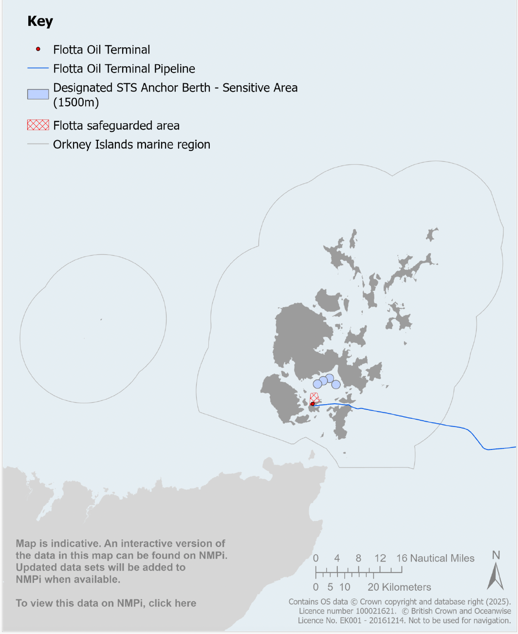
3.40 There are currently 29 piers and harbours under the jurisdiction of Orkney Harbour Authority. Orkney harbours include many components that contribute to national strategic significance, including the vast 324.5 km2 sheltered natural harbour of Scapa Flow (see Maps 14–17). Commercial ports, and associated harbour infrastructure, are located at the Hatston Terminal, Kirkwall Harbour, Lyness, Stromness Harbour/Copland’s Dock, Scapa Pier, St Margaret’s Hope and the Flotta Oil Terminal. St Margaret’s Hope is a Trust Port providing harbour facilities for ferry transport, inshore fishing and aquaculture.
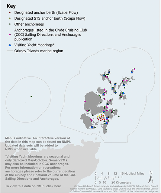
3.41 Scapa Flow is one of the principal locations in Europe for ship-to-ship (STS) operations for the transfer of crude and fuel oils. There are 15 designated anchor berths in Scapa Flow, including four STS berths.
3.42 National Transport Strategy 2 sets out a vision for Scotland’s transport system including that the Scottish Government will continue to ensure that this transport system works for island communities and delivers island connectivity, recognising the importance of ferry and air services to overall journeys[109]. Orkney communities rely on lifeline passenger and freight ferry services between Scrabster and Stromness, and Aberdeen, Kirkwall and Lerwick. A passenger and freight service operates from St Margaret’s Hope to Gill’s Bay in Caithness. Orkney Ferries operates a fleet of inter-isle ferries connecting the Outer-North, Inner-North and South Isles to Orkney’s Mainland.
3.43 The Orkney Harbours Masterplan: Phase 1 (2020)[110] outlines the indicative growth aspirations for ports and harbours operated by the Orkney Harbour Authority and has been adopted by Orkney Islands Council as Planning Policy Advice. This masterplan identifies development proposals for new pier infrastructure at Hatston and a new deep water quay facility at Deepdale, Scapa Flow, identified in Map 14, which are national developments identified in NPF4. At the time of writing, the Orkney Harbour Master Plan: Phase 2 is being prepared to align harbour and pier upgrades with new inter island ferry designs and harbour user requirements to ensure future-ready harbour infrastructure for Orkney.
3.44 The European Marine Observation and Data Network (EMODnet)[111] is a network of organisations supported by the EU’s integrated maritime policy. These organisations work together to observe the sea, process the data according to international standards and make that information freely available as interoperable data layers and data products, such as up-to-date shipping density information.
Sector Policy 3: Shipping, Ports, Harbours and Ferries
Sector Policy 3a: Safeguarding navigation, harbour infrastructure and operations
i. Proposals for development and/or activities should avoid and/or appropriately mitigate significant adverse impacts on:
a. navigational safety;
b. existing, or planned (i.e. routes associated with developments currently within the statutory consenting system), shipping and/or ferry routes*;
c. Harbour Area operations;
d. maritime access to and use of pier and harbour infrastructure, including marinas;
e. harbours of refuge;
f. designated ship-to-ship anchorages;
g. anchor berths and other anchorages, as identified on the UK Hydrographic Office Charts, including the associated 1500m sensitive areas for safe vessel manoeuvring; and
h. the Flotta Terminal Safeguarded Area.
*See European Marine Observation and Data Network (EMODnet) (europa.eu)
ii. The assessment of potential impacts on factors identified in (i) above should take into account vessel movements and harbour-related operations in all weather and tidal conditions.
iii. Development and/or activities that would have significant adverse effects on factors identified in (i) above, but which cannot be avoided or appropriately mitigated, should not be permitted.
iv. Proposals for development and/or activities should avoid, or appropriately mitigate, significant adverse impacts on the efficient use of shipping and/or ferry routes, including consideration of impacts on fuel costs, emissions, journey duration and frequency.
v. Proposals for development and/or activities should avoid, or appropriately mitigate, significant adverse impacts due to displacement of shipping and/or ferry traffic on other marine users and/or the environment.
Sector Policy 3b: Commercial ports and national developments
Marine development and/or activities should not be permitted where they would restrict access to, or future expansion of, commercial ports or existing or proposed ports and harbours that are identified as national developments in the National Planning Framework.
Sector Policy 3c: Scapa Flow north and east safeguarded area
The north and east coast of Scapa Flow, from Stromness to St Mary’s, within an area 1,500m from the shore, is a strategically important area for potential future harbour development and/or activities in the longer term. The Orkney Harbour Authority should be consulted on proposed development and/or activities within this area to enable compatibility with current and future harbour development, activities and/or operations.
Sector Policy 3d: Port and harbour development and/or activities
i. Proposals for port and harbour development and/or activities should have regard to:
a. The Orkney Local Development Plan;
b. The National Marine Plan; and
c. The National Planning Framework.
ii. Proposals for port and harbour development and/or activities should avoid, minimise and/or appropriately mitigate significant adverse impacts on:
a. landscape and/or seascape character and visual amenity;
b. nature conservation designations, protected species, and the wider biodiversity, including the national status of Priority Marine Features;
c. seal haul-out sites;
d. water quality and the benthic environment;
e. historic environment assets;
f. coastal processes including those caused by erosion, flooding and wider coastal change;
g. other coastal and marine users including, but not limited to, commercial fishing, shipping and navigation, port and harbour infrastructure/operations, marine cable routes and pipelines, active aquaculture sites, tourism, recreation, and sport and leisure activities; and
h. amenity, including consideration of road traffic, noise, light, access, vibration, odour and litter impacts.
iii. Any dredged material associated with port, harbour or shipping development and/or activities should, where appropriate, be reused for coastal protection, landscape, recreation, and/or ecological enhancement, or where this is not appropriate, such dredge material should be deposited in an appropriate dredge spoil deposit site(s).
iv. Climate change related risks and impacts, including those associated with sea level rise projections, should be taken into account in the design of port and harbour development and/or activities, to ensure that they remain viable and resilient to a changing climate over their lifetime.
Table 20: Sector Policy 3 links to Plan objectives, State of the Environment Assessment and other plans
Contribution to Regional Marine Plan objectives
Direct contribution to objectives – 1, 8, and 9.
Indirect contribution to objectives – 6.
Assessment of the condition of the Orkney Islands marine region
Orkney Islands Marine Region: State of the Environment Assessment baseline information – Section 6.4.
Alignment with other marine and land-use plans
National Marine Plan 2015 – Chapter 13.
National Planning Framework 4 – Annex B.
Orkney’s Regional Spatial Strategy (Indicative) – Strategic Priority: Sustainable Communities; Strategic Priority: Thriving Economy; Strategic Priority: An Outstanding Environment and Quality of Life.
Orkney Local Development Plan 2017 – Policy 7b ii & 12E.
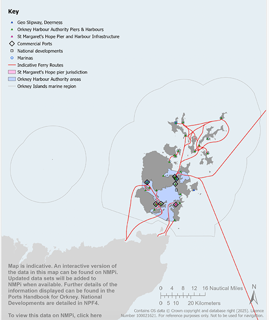
Map 14 Harbour areas, harbour infrastructure and ferry routes: Map is indicative. An interactive version of the data in this map can be found on NMPi. Updated data sets will be added to NMPi when available. Further details of the information displayed can be found in the Ports Handbook for Orkney. National Developments are detailed in NPF4.
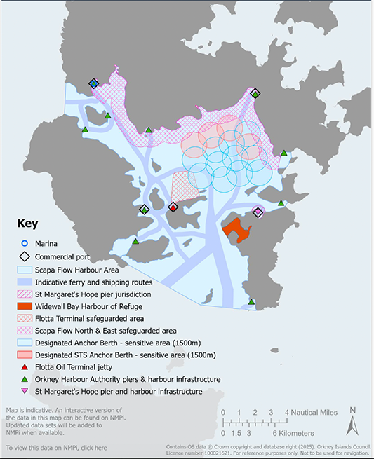
Map 15 Scapa Flow harbour infrastructure and operations: Map is indicative. An interactive version of the data in this map can be found on NMPi. Updated data sets will be added to NMPi when available.
Map 16 Anchorages: Map is indicative. An interactive version of the data in this map can be found on NMPi. Updated data sets will be added to NMPi when available. *Visiting Yacht Moorings are seasonal and only deployed May-October. Some VYMs may also be included in CCC anchorages. For more information on recreational anchorages, please refer to the current edition of the Orkney and Shetland volume if the CCC Sailing Directions and Anchorages.
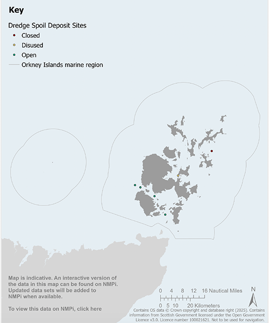
Map 17 Dredge spoil deposit sites: Map is indicative. An interactive version of the data in this map can be found on NMPi. Updated data sets will be added to NMPi when available.
Sector Policy 4: Pipeline, Electricity and Telecommunications Infrastructure
Policy IntentTo support and enable sustainable pipeline, electricity and telecommunications infrastructure, and safeguard this critical infrastructure to ensure a safe and reliable network.
Context3.45 Pipelines and electricity and telecommunications cables provide critical infrastructure to support the economic and social wellbeing of Orkney, Scotland and the UK. Within the Orkney Islands marine region, this infrastructure is vital for electricity transmission and distribution, telecommunications, the supply of potable water and removal of wastewater, and the transportation of hydrocarbons.
3.46 Sector Policy 4 only applies to public authority decisions where proposals fall within devolved competencies. Offshore oil and gas licensing is reserved to the UK Government including the construction and decommissioning of hydrocarbons pipelines; Sector Policy 4 will not be applied to these licensing decisions.
3.47 Scotland’s National Marine Plan includes policies on the factors that should be taken into account by electricity and telecommunications network and cable owners, and public authority decision makers, when reaching decisions on development and/or activities including, the laying, protection, replacement, maintenance and decommissioning of submarine cables.
3.48 Electricity transmission is the transportation of electricity from generating plants to where it is required at centres of demand. The electricity transmission network, or grid, transports electricity at high voltages through overhead lines, underground cables and subsea cables. The transmission network connects large-scale generation, primarily renewables, to central and southern Scotland and the rest of the UK. A 220kV electricity transmission cable between Dounreay in Caithness and Warebeth in Orkney was given consent in 2019.
3.49 The electricity distribution network is connected into the transmission network. The voltage is lowered by transformers at electricity substations, and the power is then distributed to homes and businesses through overhead lines, underground cables and subsea cables.
3.50 Distribution cables typically carry voltages below 33kV whereas transmission cables typically carry 132kV and above. Distribution and transmission electricity cables can have different design, installation and protection requirements, which vary with location and substrate type.
3.51 Cable and pipeline development and/or activities can have significant impacts on the marine environment; associated environmental pressures are identified in the Orkney Islands Marine Region: State of the Environment Assessment[112]. It is therefore important that these potential impacts and risks be carefully managed to safeguard the marine environment in Orkney. The degree of environmental impact depends on the type, scale, location and mitigation associated with a specific cable or pipeline development or activity.
3.52 Electricity and telecommunications cables need to be safeguarded from adverse interactions with other marine users (see Map 18). The operation, maintenance and development of the electricity network in Orkney should achieve security of supply, contribution to net-zero commitments, and the highest possible quality and safety standards. Cable owners aim to minimise risks to all marine users and the marine environment. Submarine cables should be appropriately protected, whilst achieving successful seabed user coexistence, in accordance with the National Marine Plan.
3.53 The Submarine Telegraph Act 1885 (the 1885 Act) applies to cables in UK waters and was most recently amended by the Merchant Shipping Act 1995. The 1885 Act aims to protect cables by, amongst other things, making it an offence to damage a cable, and restricting vessels and fishing activities within certain distances of cables.
3.54 As well as undertaking appropriate protection measures for their cables and for other marine users, cable owners provide information via cable awareness projects such as KIS-ORCA[113]. Cable information is given freely to fishermen and other seabed users so that they can avoid potential snagging of cables. After a new cable is laid, the UK Hydrographic Office (UKHO) issues a notice to mariners and identifies the cable on the relevant charts[114].
3.55 Crude oil is imported to the Flotta Oil Terminal via a 30-inch subsea pipeline from several offshore installations in the Flotta Catchment Area.
3.56 There are island communities in Orkney that have potable water supplied via subsea pipeline. Wastewater treatment facilities discharge wastewater via outfall pipes into the marine environment in Orkney. These infrastructures need to be safeguarded from adverse interactions with other marine users (see Map 18).
3.57 The European Marine Energy Centre (EMEC) provides facilities in Orkney for testing wave and tidal renewable energy devices that include 11kV cables running from an onshore substation to open-sea testing berths (see Map 18).
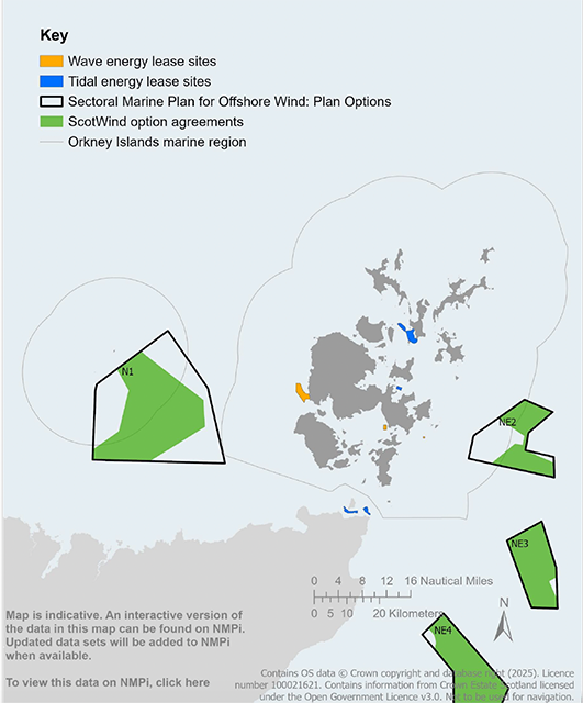
3.58 There are significant offshore wind, wave and tidal energy resources within the Orkney Islands marine region and potential for future commercial-scale renewable energy projects. The Sectoral Marine Plan for Offshore Wind Energy identifies Plan Option areas within and adjacent to the Orkney Islands marine region for commercial-scale offshore wind development. The agreements for lease within these Plan Options areas have been issued by Crown Estate Scotland via the ScotWind leasing round[115]. Such projects are likely to require grid connections, electricity and communications cables linking devices to shore.
3.59 There is potential for commercial-scale renewable energy projects to connect to shore via privately owned subsea cables for the purposes of producing zero fossil carbon fuels in Orkney. Existing oil and gas infrastructure has the potential to be repurposed to support the zero fossil carbon fuel sector (see Sector Policy 6). The key consenting requirements are outlined in Appendix 1, which is not exhaustive.
3.60 Electricity and telecommunications cables, and pipelines, in the Orkney Islands marine region are identified in Map 18.
Sector Policy 4: Pipeline, Electricity and Telecommunications Infrastructure
Sector Policy 4 is to be applied to relevant proposals for development and/or activities that require authorisation from a public authority under devolved competencies.
Sector Policy 4a: Water pipelines, electricity and telecommunications infrastructure development and/or activities
i. Proposals for water pipelines, electricity and/or telecommunications development and/or activities including the laying, protection, replacement, maintenance and decommissioning of pipelines, electricity and/or telecommunication cables, and/or the development of associated onshore and/or marine infrastructure, should have regard to:
a. The Orkney Local Development Plan;
b. The National Marine Plan; and
c. The National Planning Framework.
ii. Network and cable owners should engage with public authority decision makers, appropriate statutory bodies, marine users and local communities at an early stage to avoid, minimise and/or appropriately mitigate impacts on the historic and natural environment, existing development and/or infrastructure assets, and other marine users.
iii. Proposals for new or replacement water pipelines or cable development and/or activities should avoid, minimise and/or appropriately mitigate significant adverse impacts on:
a. landscape and/or seascape character and visual amenity;
b. nature conservation designations, protected species, and the wider biodiversity, including the national status of Priority Marine Features;
c. seal haul-out sites;
d. water quality and the benthic environment;
e. historic environment assets;
f. coastal processes, including those caused by erosion, flooding and wider coastal change; and
g. other coastal and marine users including, but not limited to, commercial fishing, shipping and navigation, ports and harbour infrastructure/operations, active aquaculture sites, tourism, recreation, sport and leisure activities.
h. amenity, including consideration of road traffic, noise, access, vibration, odour and litter impacts.
Sector Policy 4b: Safeguarding existing pipeline, electricity and telecommunications cable infrastructure
i. Proposals for development and/or activities should avoid, minimise and/or appropriately mitigate adverse impacts on pipeline, electricity and telecommunications infrastructure.
Table 21: Sector Policy 4 links to Plan objectives, State of the Environment Assessment and other plans
Contribution to Regional Marine Plan objectives
Direct contribution to objectives – 1, 8, and 10.
Indirect contribution to objectives – 2, and 3.
Assessment of the condition of the Orkney Islands marine region
Orkney Islands Marine Region: State of the Environment Assessment baseline information – Section 6.6.
Alignment with other marine and land-use plans
National Marine Plan 2015 – Chapter 14.
National Planning Framework 4 – Policy 11.
Orkney’s Regional Spatial Strategy (Indicative) – Strategic Priority: Sustainable Communities; Strategic Priority: Thriving Economy; Strategic Priority: An Outstanding Environment and Quality of Life.
Orkney Local Development Plan 2017 – N/A.
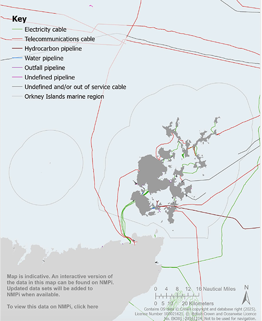
Map 18 Cables and pipelines: Map is indicative. An interactive version of the data in this map can be found on NMPi. Update data sets will be added to NMPi when available.
Sector Policy 5: Offshore Wind, Wave and Tidal Renewable Energy Generation
Policy IntentTo support and enable thriving and sustainable offshore wind, wave and tidal renewable energy generation.
Context3.61 Orkney waters are amongst the most energy-rich localities in Europe, with significant wind, wave and tidal renewable energy resources. Renewable energy developments can create significant economic opportunities for Orkney and Scotland, promoting inclusive economic development and a just transition to net zero (see Map 19).
3.62 This Plan aims to contribute to the achievement of Scottish and UK energy and climate change policy objectives and targets and minimise the potential adverse effects on the environment and other marine users from offshore wind, wave and tidal energy development and activities in Orkney waters.
3.63 Renewable energy generation development and activities can have significant impacts on the marine environment; associated environmental pressures are identified in the Orkney Islands Marine Region: State of the Environment Assessment[116]. It is therefore important that these potential impacts and risks be carefully managed to safeguard the quality and productivity of the marine environment in Orkney. The degree of environmental impact depends on the type, scale, location and mitigation associated with a specific renewable energy development or activity.
3.64 Renewable energy developments can enable transformative social and economic benefits for island communities, creating jobs, supporting local skills development and local supply chains. Large scale developments can also have significant onshore impacts on adjacent island communities including roads, housing markets, infrastructure, and community services and facilities. It is therefore important that these factors are assessed and appropriately mitigated, and environmental social and economic benefits for local communities are maximised.
3.65 The Scottish Government has prepared guidance on the Decommissioning of Offshore Renewable Energy Installations in Scottish waters or in the Scottish part of the Renewable Energy Zone under The Energy Act 2004[117].
3.66 The Orkney Renewable Energy Forum[118] represents the diverse supply chain businesses supporting the renewables sector in Orkney.
3.67 Sector Policy 6 addresses development and activities for hydrogen and other zero fossil carbon fuels.
Context: Wind energy3.68 Offshore wind energy will play a pivotal role in Scotland’s energy system over the coming decades to help tackle the Climate Emergency[119]. The Scottish Government has set a net-zero greenhouse gas emissions target for 2045, with interim targets for greenhouse gas emissions reduction of 75% by 2030 and 90% by 2040, against 1990 baseline levels. These targets are a major driver for offshore wind and wider renewable energy development and decarbonisation.
3.69 The Sectoral Plan for Offshore Wind Energy[120] sets the strategic vision and objectives for future commercial-scale offshore wind development in Scotland. This Plan has identified two Plan Option areas for future commercial-scale offshore wind development, North 1 (N1) and North East 2 (NE2), within the Orkney Islands marine region, along with a wider suite of Plan Option areas across the North of Scotland. The agreements for lease within these Plan Options areas have been issued by Crown Estate Scotland via the ScotWind leasing round[121]. The National Marine Plan contains policies for commercial scale offshore wind development and activities.
3.70 Since early 2020, EMEC has been investigating and examining options for a national floating wind test centre located to the west of Orkney. This proposal aims to create the capability to test floating platforms, turbines, cables, mooring systems and other components in metocean conditions that meet the needs of UK floating offshore wind projects anticipated for ScotWind, Innovation and Targeted Oil & Gas (INTOG) and the Celtic Sea leasing rounds[122]. This proposal will need to be considered carefully at the project level with reference to the relevant legislation, including through the Habitats Regulations Appraisal process to ascertain that there will be no adverse effect on the integrity of any European sites, or if this is not the case, that there are no alternative solutions and are imperative reasons of over-riding public interest for the proposal to proceed.
3.71 National Planning Framework 4 Policy 11 b) states that development proposals for wind farms in National Parks and National Scenic Areas will not be supported. The Hoy and West Mainland National Scenic Area (Map 10) includes significant marine areas, therefore, the relevant national planning policy is reflected in this Plan in Sector Policy 5 a) iii.
Context: Wave and tidal energy3.72 At the time of writing, the draft Plan Option areas for wave and tidal energy development have been identified in the Sectoral Marine Plans for Offshore Wind, Wave and Tidal Energy in Scottish Waters: Consultation Draft[123]. The National Marine Plan contains policies for wave and tidal energy development and activities.
3.73 Orkney is a global leader in wave and tidal energy research and development. EMEC was established in 2003 and provides a unique facility for testing wave and tidal renewable energy devices in Orkney. Wave and tidal energy, or marine renewable energy, can diversify and expand renewable energy generation to make a significant contribution to meeting net-zero targets and increase the current economic benefits to Orkney communities.
3.74 EMEC provides test and demonstration sites for wave and tidal energy devices. There are currently five test sites in Orkney:
- Billia Croo grid-connected wave energy test site, Stromness, Mainland Orkney.
- Fall of Warness grid-connected tidal energy test site, off the island of Eday.
- Caldale Hydrogen Production Plant, on Eday.
- Scapa Flow scale wave test site, off St Mary’s Bay.
- Shapinsay Sound scale tidal test site, off Head of Holland.
3.75 At each of the EMEC grid-connected test sites, there are subsea cables which run from each test berth at sea to a substation onshore, where electricity generated on-site can then be fed into the UK National Grid.
Sector Policy 5: Offshore Wind, Wave and Tidal Renewable Energy Generation
Sector Policy 5a: Offshore wind energy
i. When considering proposals for offshore wind energy development and/or activities, public authority decision makers should have regard to:
a. net economic impact, including local social and economic benefits such as employment, associated business and supply chain opportunities;
b. the scale of the contribution to renewable energy targets and the effect on greenhouse gas emissions reduction targets; and
c. cumulative impacts, taking into account the cumulative impact of existing and consented development and/or activities.
ii. Proposals for offshore wind energy development and/or activities should avoid, minimise or appropriately mitigate significant adverse impacts on:
a. landscape and/or seascape character and visual amenity;
b. nature conservation designations, protected species, and the wider biodiversity, including the national status of Priority Marine Features;
c. seal haul-out sites;
d. water quality and the benthic environment;
e. historic environment assets;
f. coastal processes including those caused by erosion, flooding and wider coastal change;
g. other coastal and marine users including, but not limited to, commercial fishing, shipping and navigation, ports and harbour infrastructure/operations, marine cable routes and pipelines, active aquaculture sites, tourism, recreation, and sport and leisure activities;
h. aviation and defence interests;
i. telecommunications, radar and broadcasting installations; and
j. amenity, including consideration of road traffic, noise, light, access, vibration, shadow flicker and litter impacts.
iii. Proposals for offshore wind farms will not be supported in the Hoy and West Mainland National Scenic Area.
Sector Policy 5b: Wave and tidal energy
i. When considering proposals for wave and tidal energy development and/or activities, public authority decision makers should have regard to:
a. net economic impact, including local social and economic benefits such as employment, associated business and supply chain opportunities;
b. the scale of contribution to renewable energy targets and effect on greenhouse gas emissions reduction targets; and
c. cumulative impacts, taking into account the cumulative impact of existing and consented energy development.
ii. Proposals for wave and tidal energy development and/or activities should avoid, minimise or appropriately mitigate significant adverse impacts on:
a. landscape and/or seascape character and visual amenity;
b. nature conservation designations, protected species, and the wider biodiversity, including the national status of Priority Marine Features;
c. seal haul-out sites;
d. water quality and the benthic environment;
e. historic environment assets;
f. aviation and/or defence interests;
g. coastal processes including those caused by erosion, flooding and wider coastal change;
h. other coastal and marine users including, but not limited to, commercial fishing, shipping and navigation, ports and harbour infrastructure/operations, marine cable routes and pipelines, active aquaculture sites, tourism, recreation, and sport and leisure activities; and
i. amenity, including consideration of road traffic, noise, light, access, vibration and litter impacts.
Table 22: Sector Policy 5 links to Plan objectives, State of the Environment Assessment and other plans
Contribution to Regional Marine Plan objectives
Direct contribution to objectives – 1, 2, 3, 4, 7, and 8.
Indirect contribution to objectives – 5.
Assessment of the condition of the Orkney Islands marine region
Orkney Islands Marine Region: State of the Environment Assessment baseline information – Section 6.5.
Alignment with other marine and land-use plans
National Marine Plan 2015 – Chapter 11.
National Planning Framework 4 – Policy 11.
Orkney’s Regional Spatial Strategy (Indicative) – Strategic Priority: Sustainable Communities; Strategic Priority: Thriving Economy; Strategic Priority: Climate Emergency; Strategic Priority: An Outstanding Environment and Quality of Life; Strategic Priority: Innovation, Research and Development.
Orkney Local Development Plan 2017 – Policy 7C, Supplementary Guidance Energy.
Sector Policy 6: Zero Fossil Carbon Fuels, and Oil and Gas Transition
Policy IntentTo support and enable a thriving and sustainable zero fossil carbon fuels sector and a just transition for the oil and gas sector.
Context3.76 Zero fossil carbon fuels, including, but not limited to, green hydrogen, ammonia, biofuels and e-fuels, are likely to play an important role in the decarbonisation of heating, transport and industrial processes. The abundant wind, wave and tidal renewable energy resources in the North of Scotland can be used to produce zero fossil carbon fuels to supply growing European markets.
3.77 Matters concerning the development of a sustainable zero fossil carbon fuels sector and a just transition for oil and gas are likely to intersect with multiple areas of regulatory consent and stakeholder interest. Accordingly, while the policy intent is consistent with and builds upon existing frameworks and strategic objectives, its application is specifically intended to support public authority decision-makers where proposals fall within devolved competencies
3.78 The Orkney Hydrogen Strategy[124] aims to develop a sustainable hydrogen economy in Orkney to help meet net-zero targets, create local jobs, and develop a local supply chain and a more resilient local energy system. The strategy seeks to establish Orkney as the global exemplar in green hydrogen integration, supporting a robust rural net-zero economy.
3.79 Orkney has been a demonstration region for numerous green hydrogen demonstration projects. These projects, including Surf ’n’ Turf and Building Innovative Green Hydrogen in Isolated Territories, have produced hydrogen from renewable sources, including community-owned wind energy and tidal energy installations.
3.80 Zero fossil carbon fuel production can provide an energy storage solution when renewable energy generation is exceeding demand or is curtailed by limited grid capacity. These fuels can help to maximise green energy utilisation, enhance the economic viability of affected renewable energy projects and support island sustainability.
3.81 The higher cost of electricity transmission charges for renewable energy projects in the North of Scotland is expected to be a major driver for the production of zero fossil carbon fuels from renewable energy developments in and around Orkney waters. It is anticipated that renewable energy generation projects will export electricity to the grid and consider the option of using generated electricity to produce zero fossil carbon fuels. Offshore renewable energy developments may need to connect to shore via privately owned subsea and/or onshore cables for the purposes of producing zero fossil carbon fuels in Orkney.
3.82 The Flotta Oil Terminal is a strategically important industrial asset that imports crude oil via a subsea pipeline from several offshore installations in the Flotta Catchment Area. The terminal operator and their partners have explored diversification options to enable a transition to low and zero fossil carbon fuel production and distribution activities[125]. The Flotta Oil Terminal is a Control of Major Accident Hazards site[126].
3.83 Looking ahead, Orkney has extensive harbour, oil and gas infrastructure that has potential to be repurposed to produce and distribute zero fossil carbon fuels.
3.84 Orkney Harbour Authority aims to play a key role in decarbonisation by enabling a transition from hydrocarbons to zero fossil carbon fuels for shipping and ports. This shift to greener fuels will require a stepped transition from Low Sulphur Fuel Oil and Marine Gasoil to Liquid Natural Gas, leading to future hydrogen and/or ammonia carbon free fuelling for shipping.
3.85 Scapa Flow is one of the principal locations in Europe for ship-to-ship operations for the transfer of crude and fuel oils, Liquid Natural Gas and Liquid Petroleum Gas (see Map 20). These operations are licenced by the MCA under the terms of the Merchant Shipping (Ship-to-Ship Transfers) Regulations 2010.
Sector Policy 6: Zero Fossil Carbon Fuels, and Oil and Gas Transition
Sector Policy 6 is to be applied to relevant proposals for development and/or activities that require authorisation from a public authority under devolved competencies.
i. Proposals for development and/or activities for the production and/or distribution of zero fossil carbon fuels, including associated cable and/or pipeline infrastructure, and/or the development of associated onshore and/or marine infrastructure, should have regard to:
a. The Orkney Local Development Plan;
b. The National Marine Plan; and
c. The National Planning Framework.
ii. Proposals to repurpose existing oil and gas infrastructure for the production and/or distribution of zero fossil carbon fuels should be consistent with the objectives and policies of this Plan, the Orkney Local Development Plan, the National Marine Plan and the National Planning Framework 4.
iii. Proposals for pipeline and/or electricity cable development and/or activities for the purpose of producing and/or distributing zero fossil carbon fuels that include the laying, replacement, maintenance and decommissioning of pipelines, electricity and/or telecommunication cables should have regard to Sector Policy 4.
Table 23: Sector Policy 6 links to Plan objectives, State of the Environment Assessment and other plans
Contribution to Regional Marine Plan objectives
Direct contribution to objectives – 1, and 3.
Indirect contribution to objectives – 4.
Assessment of the condition of the Orkney Islands marine region
Orkney Islands Marine Region: State of the Environment Assessment baseline information – Section 6.7.
Alignment with other marine and land-use plans
National Marine Plan 2015 – Chapter 9.
National Planning Framework 4 – Policies 1 and 11.
Orkney’s Regional Spatial Strategy (Indicative) – Strategic Priority: Sustainable Communities; Strategic Priority: Thriving Economy; Strategic Priority: Climate Emergency; Strategic Priority: An Outstanding Environment and Quality of Life; Strategic Priority: Innovation, Research and Development
Orkney Local Development Plan 2017 – N/A.
Map 20 Oil and gas infrastructure: Map is indicative. An interactive version of the data in this map can be found on NMPi. Updated data sets will be added to NMPi when available.
Sector Policy 7: Tourism, Recreation, Leisure and Sport
Policy IntentTo support and enable a thriving and sustainable tourism, recreation, leisure and sport sector.
Context: Tourism3.86 The many special qualities of Orkney make it a world-class tourist and leisure destination. There are numerous islands with unique characteristics to explore, and a diverse range of opportunities for marine recreation, sport and leisure.
3.87 Tourism is an important economic driver in Orkney, providing a wide range of employment opportunities whilst bringing significant money into the local economy through visitor spending[127].
3.88 Orkney’s environmental quality, natural and cultural heritage, and historic environment underpin the success of the tourism sector. It is therefore important to protect these special qualities and assets to ensure the long-term sustainability of tourism and recreation, and the associated benefits enjoyed by local communities. As identified in the Orkney Islands Marine Region: State of the Environment Assessment, tourism infrastructure, development and activities can have significant impacts on the environment[128]. It is therefore important that these impacts be carefully managed to safeguard the quality and productivity of the coastal and marine environment in Orkney.
3.89 Sustainable tourism requires investment in infrastructure and can provide an incentive for conservation and environmental enhancement investments that benefit the wider community[129].
Context: Recreation, leisure and sport3.90 Coastal and marine recreation, leisure and sport provide significant wellbeing benefits to local communities and visitors. Popular activities include, for example, paddle sports, recreational boating, surfing, diving, recreational fishing, swimming, coastal walking, birdwatching and competitive sport. This includes both formal and informal activities undertaken by individuals, clubs and commercial ventures.
3.91 Orkney’s attractive coastal scenery, wildlife, historic assets and beaches are some of the many assets enjoyed by those engaging in marine and coastal recreational, leisure and sport activities. Clean and healthy seas and coastlines are fundamentally important to the enjoyment of these activities. Spending time in the coastal and marine environment has also been shown to enhance mental wellbeing and physical health, leading to an improved quality of life.[130]
3.92 Orkney’s coastal infrastructure and facilities, including the core path network[131], anchorages (see Map 21), and the many marine access points, including marinas, piers and slips (see Map 14), are key to enabling a diverse range of recreational uses and are important assets that need to be safeguarded and enhanced.
3.93 Sector Policy 7 aims to ensure that tourism, recreation, leisure and sport development, activities and/or use protect and, where appropriate, enhance the environment in which they operate. In addition to this policy, tourism recreation, leisure and sport development and/or activities will be assessed in accordance with other relevant policies in the Plan (e.g. harbour infrastructure developments for tourism will also be assessed under Sector Policy 3). Furthermore, this policy aims to avoid or reduce adverse impacts on tourism, recreation, sport and leisure uses.
3.94 Further information on tourism, recreation, leisure and sport in Orkney is provided in the Orkney Islands Marine Region: State of the Environment Assessment[132]. The Orkney Coastal and Marine Recreational Survey[133] provides spatial information on recreation, sport and leisure uses in the Orkney Islands marine region.
Sector Policy 7: Tourism, Recreation, Leisure and Sport
Sector Policy 7a: Tourism, recreation, leisure and sport development and/or activities
i. Proposals for tourism, recreation, leisure and sport development and/or activities should have regard to:
a. The Orkney Local Development Plan;
b. The National Marine Plan; and
c. The National Planning Framework.
ii. Proposals for tourism, recreation, leisure and sport development and/or activities should avoid, minimise or appropriately mitigate significant adverse impacts on:
a. landscape and/or seascape character and visual amenity;
b. nature conservation designations, protected species, and the wider biodiversity, including the national status of Priority Marine Features;
c. seal haul-out sites;
d. water quality and the benthic environment;
e. historic environment assets;
f. coastal processes including those caused by erosion, flooding and wider coastal change;
g. other coastal and marine users including, but not limited to, commercial fishing, shipping and navigation, ports and harbour infrastructure/operations, marine cable routes and pipelines, active aquaculture sites, tourism, recreation, and sport and leisure activities; and
h. amenity, including consideration of road traffic, noise, light, access, vibration and litter impacts.
iii. Proposals for tourism, recreation, leisure and sport development and/or activities should follow relevant codes of best practice and guidance, including, but not limited to, the Marine Wildlife Watching Code, the Scottish Outdoor Access Code, biosecurity practices and marine litter/waste guidance.
iv. To maximise the benefits from existing infrastructure, proposals for tourism, recreation, leisure and sport development and/or activities should demonstrate that they have considered the potential to utilise appropriate existing infrastructure and/or facilities, including shared use with complementary activities and sectors.
Sector Policy 7b: Safeguarding tourism, recreation, leisure and sport uses
i. Proposals for development and/or activities should consider options to avoid, minimise or appropriately mitigate significant adverse impacts on tourism, recreation, leisure and sport uses.
ii. Proposals for development and/or activities should demonstrate engagement and/or consultation with relevant tourism, recreation, leisure and sport bodies and/or users to ensure that the measures proposed to avoid, minimise and/or mitigate adverse impacts on tourism, recreation, sport and leisure uses are appropriate.
Table 24: Sector Policy 7 links to Plan objectives, State of the Environment Assessment and other plans
Contribution to Regional Marine Plan objectives
Direct contribution to objectives – 1, 2, 6, 7 and 10.
Indirect contribution to objectives – 5.
Assessment of the condition of the Orkney Islands marine region
Orkney Islands Marine Region: State of the Environment Assessment baseline information – Section 6.9.
Alignment with other marine and land-use plans
National Marine Plan 2015 – Chapter 12.
National Planning Framework 4 – Policy 30.
Orkney’s Regional Spatial Strategy (Indicative) – Strategic Priority: Sustainable Communities; Strategic Priority: Thriving Economy; Strategic Priority: An Outstanding Environment and Quality of Life.
Orkney Local Development Plan 2017 – Policy 10A.
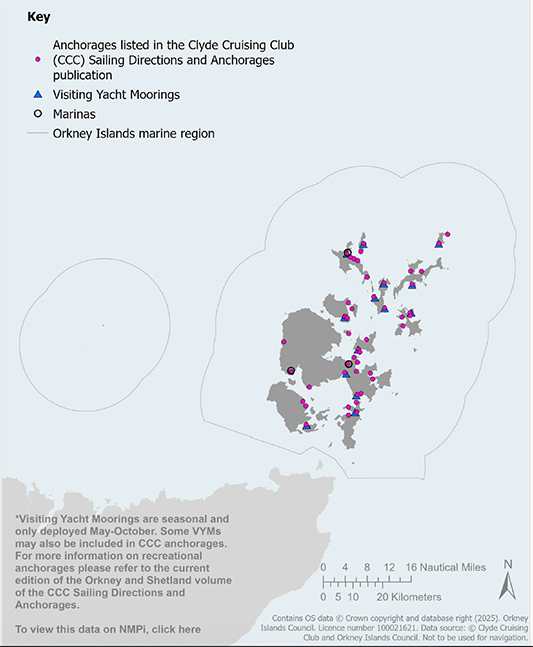
Map 21 Recreational Anchorages, visiting yacht moorings and marinas: *Visiting Yacht Moorings are seasonal and only deployed May-October. Some VYMs may also be included in CCC anchorages. For more information on recreational anchorages please refer to the current edition of the Orkney and Shetland volume of the CCC Sailing Directions and Anchorages.