Developing essential fish habitat maps: report
The project helped define areas of the sea essential to fish for spawning, breeding, feeding, or growth to maturity. Twenty-nine species and multiple life-stages were reviewed covering marine fish and shellfish of commercial and ecological importance, relevant to offshore wind development areas.
1. Introduction
1.1 Background
Marine spatial planning is essential to the management of the activities, resources and assets in marine waters to ensure sustainable development in the marine environment. One of the aims of marine planning is to identify 'areas of preference' for development, so that projects can be sited appropriately while avoiding conflicts with areas of high value to existing users (including fishing) and to conservation interests.
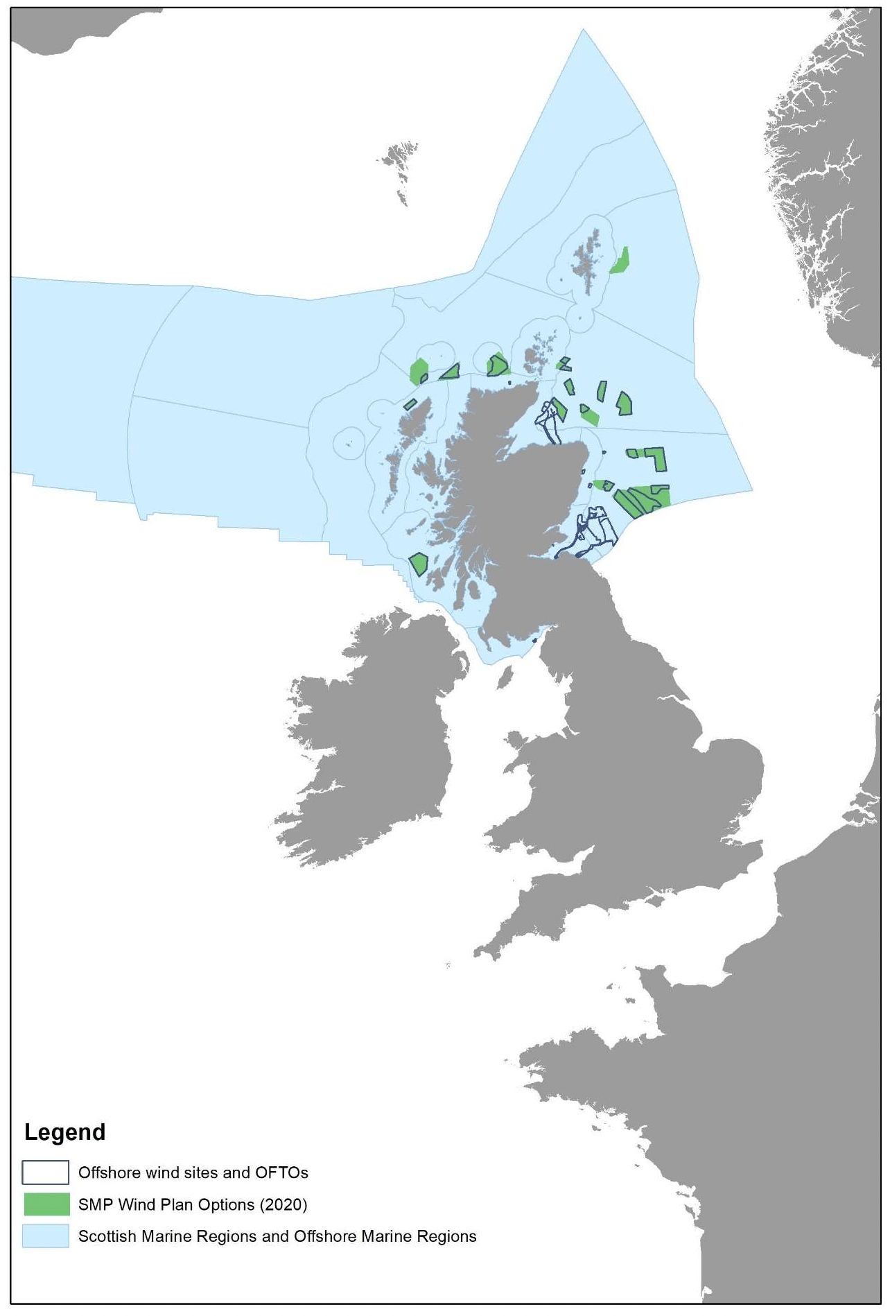
Marine spatial planning is of particular relevance in light of the likely substantial expansion of the offshore wind industry in Scotland over the next decade and beyond. Offshore wind is expected to play a large role in meeting the Scottish and UK Governments' commitments towards clean energy and climate change targets, and a green economic recovery. Marine Scotland Directorate, as Planning Authority for Scotland's Seas, has developed a Sectoral Marine Plan for Offshore Wind Energy (SMP) that has identified geographical areas as sustainable options (Plan Options) for future commercial scale offshore wind developments (Figure 1). The Scottish Marine Energy Research (ScotMER) Programme has been established by Marine Scotland Directorate to identify and address scientific uncertainties when assessing the potential impact of offshore renewable developments on the marine environment and other users of the sea, to de-risk the consenting process, and support the sustainable development of Scotland's waters.
A robust understanding of the distribution of the resources and assets provided by the marine environment, at the appropriate spatial resolution and with enough confidence, is key to this process. This would also benefit the management of other sectors which use the marine environment and the resources it provides (e.g. fisheries, oil and gas industry), as well as support consideration of nature conservation measures. This includes the understanding of the distribution of ecologically important habitats, which support key phases of fish (or shellfish) life history (e.g. spawning and nursery grounds), thus ensuring the viability of wild populations and provision of the associated ecosystem services. These are commonly known as Essential Fish Habitats.
1.2 Essential Fish Habitat
The term Essential Fish Habitat (EFH) was first used in US legislation to identify "...those waters and substrata necessary to fish for spawning, breeding, feeding, or growth to maturity" (U.S. Magnuson-Stevens Fishery Conservation and Management Act 1976). This has been integrated as a tool for marine fisheries management in current U.S. legislation (U.S. Sustainable Fishery Act 1996; EFH Regulatory guidelines, NMFS / NOAA Rule 2002).
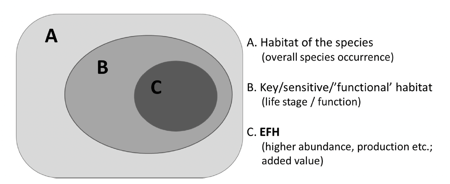
In this context, 'habitat' may be intended in its widest meaning as the combination of environmental conditions (e.g. physico-chemical and hydrodynamic characteristics, but also including biotic conditions) and structural components (e.g. substratum and habitat types), which characterise an area (in general or at a certain point in time). A conceptual representation of EFH of a species, and how it differentiates from other habitats used by the species, is given in Figure 2. This reflects the EFH concept as applied in this project.
EFH is often associated with the function it performs for key phases of a species life history. Between species, it may have variable degrees of overlap (environmental and spatial) with the habitat (or habitat mosaic) used by the species throughout its whole life cycle due to ontogenetic changes in environmental tolerance ranges and optima (Rijnsdorp et al. 2009, Freitas et al. 2010). For example, nursery habitats provide food and space (shelter) to juveniles of a species, thus enhancing their survival and growth before they recruit back into the adult population. In marine migrant fish (e.g. some flatfish and gadoids), these habitats are distinct from the adult habitats, with nursery grounds mostly occurring in estuaries and
shallow, enclosed coastal bays, whereas adult habitats are mostly at sea (Franco et al. 2008, Potter et al. 2015). Spawning grounds provide optimal conditions for reproduction, e.g. favouring egg/spawn survival and their successful transport into nursery areas. Similarly, habitats with a particular role in sheltering a species, e.g. from predators (refuge function), may also be considered as EFH (the refuge function being inherent in the nursery habitat definition when only juveniles directly benefit from it).
The mere association of a habitat with a life stage is not enough to identify it as an EFH. For example, Beck et al. (2001) distinguished between habitats where juveniles occur (see habitat B in Figure 2) and nursery grounds, the latter having an added value in their greater contribution (per unit area) to the production of individuals that recruit into adult populations (see habitat C in Figure 2). This added value is reflected, for example, by the increased density of juveniles, their enhanced survival or reduced mortality, increased growth rates and biomass production (Beck et al. 2001), as also found in other studies (e.g. Kraus and Secor 2005, Franco et al. 2010, Ciotti et al. 2013). Habitat connectivity is also a key element that ensures that the benefit gained locally within the EFH site is extended into the wider population (e.g. through successful export of the juvenile biomass from nursery grounds into marine adult populations; Gillanders et al. 2003, Able et al. 2022).
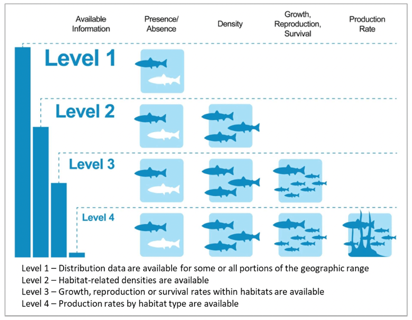
Therefore, to fully identify EFH, information on the species (or the relevant life stage) is needed at multiple levels of detail, from presence/absence to density, growth, reproduction, survival and production rate (NMFS and NOAA 2002). This type of data can be derived from survey catch data (e.g. size-frequency distribution analysis, as in Franco et al. 2010), although in some cases additional specialist analyses may also be needed (e.g. otolith microchemistry analysis, as in Gillanders et al. 2003 and Kraus and Secor 2005; RNA and DNA concentrations, as in Ciotti et al. 2013). A trade-off exists between the level of detail and availability of such data, and the operational application of the EFH concept for management purposes (EFH designation) often relies on more widely available but lower- level information (Level 1 and Level 2 in Figure 3; NMFS and NOAA 2002).
1.3 Aims and objectives
Understanding where essential fish habitats are located is vital to support effective habitat protection and healthy fish and shellfish populations, as well as predicting how habitats and resultant effects on fish and shellfish population may change (e.g. with climate change).
However, evidence gaps in the knowledge base have been identified for Scotland (within ScotMER) as well as widely for UK waters (Marine Management Organization[1]).
Studies on EFH and their spatial distribution have been produced over the years, but available EFH models and maps may be outdated and/or insufficiently resolved (e.g. ICES[2]rectangle) for the use in marine planning (e.g. Coull et al. 1998, Ellis et al. 2012, Aires et al. 2014), or they do not cover Scottish waters (e.g. Franco et al. MMO 2013, 2016, AFBI 2021, Katara et al. 2021). Furthermore, there is a data gap for inshore waters, despite these areas holding ecologically important habitats and habitat complexes for fish and shellfish
(e.g. seagrass and saltmarsh, estuaries). EFH assessments and maps for inshore waters are scarce for the whole UK, and they are generally produced for local areas (e.g. Elliott et al. 2017 in Scottish waters) thus limiting their wider applicability.
As a result, the Scottish Government commissioned this study with the aim of developing the evidence base on EFH to inform future planning and project level assessments in Scottish waters, thus pulling together all available evidence to assist with wider UK planning and project assessments. The results of this study will help the regulators to understand where further work is required to inform consenting decisions (they will not be used to identify conservation measures as this would require a greater degree of robustness).
Specific objectives of this study are:
- 1. To identify, collate and standardise existing fishery and environmental data sources to develop high quality EFH models and GIS maps for relevant fish and shellfish species in Scotland (also including identification of data gaps and future data collection requirements).
- 2. To develop high quality EFH models and maps to deliver a national coverage (covering Scottish waters, UK-wide where possible) for relevant species with defined statistical confidence.
- 3. To explore viable alternative ways of mapping EFH for inshore waters through a systematic literature review, to identify habitat proxies for EFH functions, their applicability and with defined confidence.
- 4. To consider how climate change may affect EFH and give recommendations on how to take this into account for future planning and project level assessments.
1.4 General approach
In order to account for the variable data availability between species and inshore and offshore areas[3], a two-fold approach was applied to the identification of essential fish habitats.
Species distribution models (specifically Decision Tree models) were calibrated where broad- scale fish survey data were available for the study period 2010 - 2020 and correspondent environmental conditions could be derived from environmental layers based on survey locations and timings. The spatial distribution of the potential EFH for the species was then predicted based on the mapped environmental conditions under a selected environmental scenario (mean conditions over the ten-year study period). A confidence assessment was associated with the models and their spatial prediction taking into account the model performance (upon statistical validation of model predictions against a test dataset), and confidence estimates for the input data used to calibrate and predict the models (fish survey and environmental layers). As the data used in this approach were mostly available for marine areas offshore, the resulting maps provided poor coverage of inshore waters.
Data availability in inshore areas may be limited, e.g. due to a higher fragmentation (multiple, localised surveys undertaken by different bodies and for different reasons, e.g. ecological monitoring, impact assessment) and lower standardisation of surveys. Identifying, collating and harmonising these survey data (if made available by the respective providers) would require longer time than was available in this project. In addition, spatial coverage of environmental layers required for the modelling can be limited, especially in internal waters that are often poorly covered by broad scale environmental maps. Therefore, for inshore waters, a semi-quantitative assessment was applied to identify potential habitat proxies for EFH. The approach was similar to the one used in Amorim et al. (2017) to assess habitat attractiveness for estuarine fish communities. Different habitat types (identified based on EUNIS habitat classification) were scored according to their ability to provide EFH function to a species, with the habitat types with higher scores being used as proxies for EFH. The scoring was based on expert assessment as informed by a literature review and complemented through expert consultation. A confidence was allocated to each scoring based on the supporting evidence/knowledge.
For both approaches, examples of their spatial implementation (maps) were compared with survey data (where available) and, where possible, subjected to external examination by stakeholders for additional validation.
1.5 Report content
The report provides the main information on the methods, results and discussion of the findings and is supported by annexes as detailed below.
Section 2 reports on the methods applied, from the literature review, to the data collation and processing, modelling and habitat proxy assessment, the mapping procedure for both approaches, map validation via data and stakeholder feedback. The methodology used to assess the implications of climate change of EFH distribution (as required by objective 4) is also reported in this section. Additional specific details have been provided in separate technical annexes:
- Annex 1 provides details on the literature review methodology and the tabulated results.
- Annex 2 provides details on the data-based modelling approach used in the study and guidance on how to interpret and apply them for predicting the potential distribution of aggregations of a species/life stage.
- Annex 3 gives details on the methodology used to estimate confidence for the models and associated spatial predictions presented in the main report.
Section 3 reports on the main results obtained. The habitat assessment tools (decision tree model and habitat proxy matrix) and the resulting spatial implementation (maps) are presented by species, and for their relevant life stage(s), i.e. the life stage(s) associated to a specific EFH function relevant to the species. Interpretation and discussion of the specific results is included in this section, also accounting for the map validation via comparison with survey data and stakeholder feedback. The results of the assessment of the implications of climate change of EFH distribution are also reported in this section.
Section 4 provides a general discussion of the outputs of this project, also identifying gaps and recommendations for use of the outputs and their possible improvement.
Contact
Email: ScotMER@gov.scot