Sectoral marine plan for offshore wind energy
Aims to identify sustainable plan options for the future development of commercial-scale offshore wind energy in Scotland, including deep water wind technologies, and covers both Scottish inshore and offshore waters.
4. Plan Options
4.1 National perspective
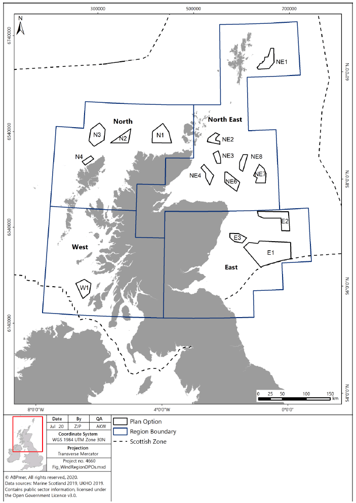
The Plan identifies 15 POs across four regions within Scottish Waters (see Figure 11). As the POs are spatially distinct within the four regions, there is limited potential for cumulative negative effects at a national scale. Conversely, there exists the potential for cumulative positive effects through a significant contribution to the decarbonisation of the energy sector in Scotland and the establishment of a secure energy supply.
Regional cumulative effects include the potential for negative effects on bird populations, benthic habitats, cetaceans, navigational safety, seascape/landscape and commercial fisheries. It is recognised that both regionally and nationally the level of impacts will vary according to which POs become the focus of development. The development of multiple POs within a region could form a potential barrier for mobile species (such as seabirds, diadromous fish and cetaceans) or result in the diversion of shipping and fishing traffic routes, or concentration of vessel traffic into smaller areas. The North East region, for example, has the largest number of POs and, therefore, the scale of potential positive and negative impacts from this region may be higher and opportunities to mitigate potential negative impacts may be comparatively more limited if development is concentrated in this region.
In line with the conclusions of the SA, HRA, SEA and SEIA, the Plan includes measures to mitigate potential impacts at various scales, including the requirement for further spatial planning within individual POs and limiting the scale of development under this iteration of the Plan to 10 GW nationally.
Whilst 10 GW was used as a total maximum realistic development scenario for the Plan as a whole, the individual PO scenarios (shown in Table 1) should not be taken as being an endorsement of projects up to this size within a PO, as further project level assessment and planning will be required to ensure avoidance of significant adverse effects.
The following sections summarise the most significant potential opportunities and constraints that developers will need to overcome in each PO and region. This is not intended to be an exhaustive list of all potential impacts which could occur and project-level impacts will need to be identified via further project-level assessment, which will benefit from the further level of detail required at that scale.
The SA, SEA and HRA provide a list of suggested project-level mitigation measures, however, these will vary according to the scale, nature and location of the proposed development. The following types of potential negative impacts have been identified and assessed in the SEA, HRA and SEIA and will require further consideration (in addition to any specific potential impacts appropriate to the proposed development) at a project-level;
- Loss of/damage to marine and coastal habitats;
- Effects from pollution releases on species and habitats;
- Effects on subsea geology, sediments and coastal processes arising from changes in hydrodynamics and existing wave regimes;
- Issues relating to navigational safety, aviation and collision risk;
- Effects on marine and coastal recreation and access;
- Effects on landscape and coastal characters and visual receptors;
- Contribution to supporting a diverse and decarbonised energy sector;
- Effects from the introduction and spread of Invasive Non Native Species;
- Effects on residential amenity;
- Loss of/damage to historic environment features and their settings;
- Effects arising from noise, vibration, light, dust and shadow flicker;
- Effects on water quality; and
- Effects on ecological status.
Due to the level of uncertainty surrounding potential cable routes to shore, landfall locations and grid connection, a detailed assessment of specific cable routes to shore has not been included in the SA. The SEA, HRA, SEIA and RLG assume that any area inshore of a PO could be utilised as a cable route and identifies areas of higher sensitivity for cable routes and landfall points. Developers are expected to take into consideration sensitive areas at a project-planning level and undertake early engagement with key stakeholders regarding survey requirements, cable routing and burial/protection methods.
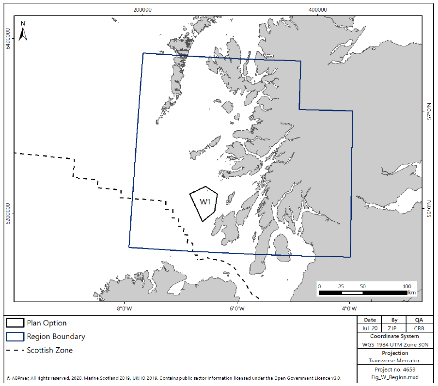
4.2 West Region
The West region encompasses one PO (W1), located off the coast of Islay (as shown in Figure 12).The key risk factors to development within the West region are:
- potential visual impacts and landscape/seascape character impacts;
- potential impacts on marine mammal receptors;
- potential impacts on commercial shipping;
- risks to bird species, including collision risk and displacement, as well as potential impacts to birds on migratory pathways;
- potential impacts on benthic habitats and species;
- potential impacts on migratory fish species;
- potential impacts on commercial fishing;
- potential impacts on recreational angling; and
- potential cost impacts and associated navigational risk from diverting key commercial shipping routes.
Within the West region, there is the potential for tidal energy development in this region and three leases were previously awarded for tidal stream installation (including Isle of Islay, Sound of Islay and Connel), however, none of these sites are currently operational (although consents have been awarded for the Isle of Islay and Sound of Islay sites). These projects may need to be considered within any in-combination assessment. The SEA recognises the potential for cumulative effects on migrating birds with currently installed wind turbines at the Robin Rigg windfarm and other west coast DPOs in the North region.
4.2.1 W1
W1 covers a total area of 754 km2 and offers a potential maximum realistic deployment scenario of up to 2 GW of generating capacity (equating to 53% of the total area of the DPO). The majority of the DPO is in shallow water (< 60 m) but gets deeper to the north-west..
The SEIA identifies generally lower socio-economic costs arising from potential offshore wind development within the PO, with the most significant cost to the recreational angling sector, however, commercial fisheries, particularly static gear, may also be impacted by development.
There would be the potential for adverse visual impacts and impacts on seascape and landscape character, due to the proximity of the PO to shore, particularly the south eastern part of the PO, however, these impacts may be reduced or avoided via project-level mitigation measures and the now increased distance from shore due to the modified PO. The western part of the PO is located close to a shipping route but avoids the main thoroughfare. Project-level mitigation measures may be required to address potential impacts on commercial shipping and navigational safety.
Consultation would be required with the Ministry of Defence ("MOD") regarding potential offshore safeguarding concerns due to potential Royal Navy activities within W1.
Diadromous fish, particularly Atlantic Salmon, are likely to be present within this PO. Although the exact location of migration routes or connectivity to specific rivers is not known, mitigation at the project-level may be required to avoid potential negative impacts.
Mitigation to reduce, avoid or offset impacts on marine mammals (including harbour porpoise, basking shark and seals) during construction activities would need to be considered at a project level, given the proximity of W1 to a number of designated and protected sites. Consideration would also need to be given to potential impacts on benthic features (deep sponge communities) located to the north west corner of W1, as well as potential impacts on migratory whooper swans.
4.2.2 Key actions for the West region
In order to progress development in the West region, the following (non-exhaustive) key steps are likely to form part of the development process:
- consultation with stakeholders in Argyll and Bute regarding landscape and seascape concerns;
- consultation with MOD regarding potential interaction with Royal Navy activities;
- consultation with the fishing community;
- pre- and post-consent, and post-construction, bird monitoring;
- benthic survey and spatial planning to avoid significant effects on benthic PMF receptors; and
- mitigation of potential cost impacts and associated navigational risk from diverting key commercial shipping routes.
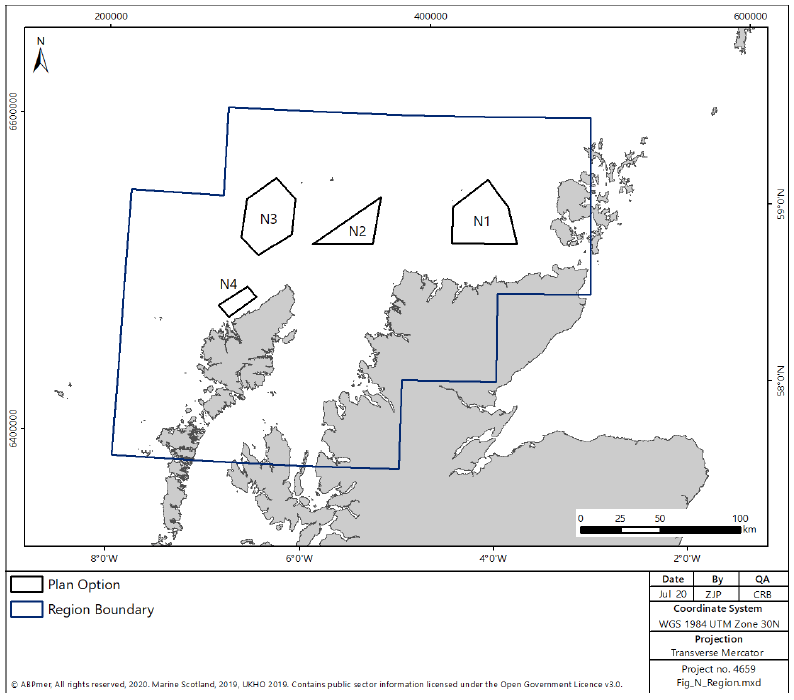
4.3 North region
The North region encompasses four POs (N1, N2, N3 and N4) (as shown in Figure 13). The key risk factors to development within the North region are:
- Potential adverse visual impacts and landscape/seascape character impacts;
- potential impacts on marine mammal receptors;
- risks to bird species, including collision risk and displacement, as well as potential impacts to birds on migratory pathways;
- potential impacts on commercial fishing;
- potential impacts on migratory fish species;
- potential impacts on benthic habitats and species; and
- potential impacts on recreational angling.
Within the North region, there is one demonstration wind energy development which holds a valid consent (Dounreay Tri) but has not begun construction. In addition, a number of tidal and wave devices have been deployed in the waters around Orkney as part of the European Marine Energy Centre ("EMEC") and Phase 1 of the MeyGen tidal array is currently operational in the Pentland Firth. Development across multiple POs in this region may result in cumulative impacts on a range of receptors, including migratory birds, cetaceans and fish species.
Development across multiple POs in this region will require careful consideration of cumulative impacts on bird species, particularly focussing on migratory species and flyways, with increased turbine heights, as well as the consideration of collision risk, displacement and barrier effects to seabird populations. Migration pathways for migratory bird species transiting from the UK towards the Faroe Islands and Iceland intersect POs in this region and development within multiple POs could result in cumulative barrier effects, increased collision risk and increased energetic requirements for these birds.
Concurrent construction activities in this region could result in significant cumulative impacts on marine mammals, which would need to be considered and mitigated at a project and regional level.
Diadromous fish, particularly Atlantic Salmon, are likely to be present within the POs in this region. Although the exact location of migration routes or connectivity to specific rivers is not known, mitigation at the project-level may be required to avoid potential negative impacts.
In addition, if development were undertaken at both POs N3 and N4 there may be cumulative visual, seascape and landscape impacts (due to the proximity of these POs to the coastline and their ability to be seen from the same single viewpoints). Navigational safety should also be considered at a project level if development at both POs progresses. These impacts would therefore need further consideration and mitigation at a project-level.
4.3.1 N1
N1 covers a total area of 1163 km2 and offers a potential maximum realistic development scenario of up to 2 GW of generating capacity (equating to 34 % of the total area of the PO). The water depth across the PO varies, with areas of shallow water (< 60 m) and areas of deeper (>60 m) water dispersed across the PO.
The SEIA identifies potential impacts on the commercial shipping sector, which could be reduced or offset via project-level mitigation measures or spatial planning within the PO. There is also the potential for significant cost impacts associated with the loss of fishing grounds in N1. Key gear types in N1 are demersal trawls and creels. It is recognised that of these, the creels may not be displaced in the medium to long term.
The SEA identifies potential effects on bird populations including connectivity with nearby SPAs, such as Sule Skerry and Sule Stack SPA, as well as Orkney SPAs. As such, additional research, spatial planning and consideration of further mitigation at a project level may be required within N1 to avoid areas of key usage for bird species or reduce potential impacts.
4.3.2 N2
N2 covers a total area of 561 km2 and offers a potential maximum realistic development of up to 2 GW of generating capacity (equating to 71% of the total area of the PO).The water depth across the PO is generally deeper (60-100 m) water with some areas of deep water (> 100 m) in the west of the PO.
There is some potential for significant cost impacts associated with the loss of fishing grounds in N2, particularly in relation to demersal trawlers, which are likely to be excluded from the footprint of any offshore wind development.
Consultation would be required with the MOD regarding potential offshore safeguarding concerns due to Royal Navy activities within N2.
NatureScot highlight the potentially significant visual, seascape and landscape impacts resulting from development in this PO.[35] This is primarily due to the proximity to Cape Wrath and NatureScot suggest development should be focussed in the north west of the PO.
4.3.3 N3
N3 covers a total area of 1106 km2 and offers a potential maximum realistic development scenario of up to 2 GW of generating capacity (equating to 36% of the total area of the PO). The water depth across the PO is generally deep (> 100 m) with some small areas of shallower water (< 60 m) in the northeast of the PO.
The SEIA identifies potential significant cost impacts associated with the loss of fishing grounds in N3. Key gear types in N3 are midwater and demersal trawls which are likely to be excluded from the footprint of any offshore wind development.
Consultation would be required with the MOD regarding potential radar interference from turbines in N3.
The SEA identifies potential risks associated with bird species foraging in the northeast of the PO from the North Rona and Sula Sgeir SPA and migrating bird species transiting towards the Faroe Islands and Iceland. To address these risks at a project level, appropriate pre-consent bird surveys, mitigation measure development and post-construction monitoring would be required.
4.3.4 N4
N4 covers a total area of 200 km2 and offers a potential maximum realistic development scenario of up to 1 GW of generating capacity (equating to 100% of the total area of the PO). The water depth across the PO is shallow (< 60 m) throughout, with a small area of 60-100 m water depth in the southwest of the PO.
The SEIA identifies potential cost impacts to recreational angling, tourism and commercial fishing sectors. The presence of N4 close inshore from the recommended deep water route around the Hebrides on a lee shore may also affect navigational safety and these impacts would need to be considered and mitigated at a project-level.
Impacts to the tourism sector are associated with potential visual, landscape and seascape issues, which similarly is the most significant risk identified within the SEA. N4 is located in very inshore waters, and therefore seascape, landscape and visual impacts will occur. NatureScot advise that a detailed design-led approach involving the local stakeholders should be utilised if a project is identified here. Consideration of these impacts would require early consultation with local communities and stakeholders. Potential mitigation measures may be limited, however, consideration could be given to wind farm design and turbine selection, (i.e. the selection of smaller turbines to reduce visual impact).
Further to the potential landscape, seascape and visual impacts, the SEA identifies potential noise impacts to local populations, due to the PO's close proximity to land, which will need management through early and comprehensive consultation with local stakeholders and communities.
4.3.5 Key actions for the North region
In order to progress development in the North region, the following (non-exhaustive) key steps are likely to form part of the development process. It is recognised that some steps will be more applicable to specific POs within the North region:
- consultation with local stakeholders regarding landscape and seascape concerns; and potential noise impacts on local populations;
- pre- and post-consent, and post-construction, bird monitoring;
- consultation with the MOD;
- consultation with the fishing community;
- consideration of potential impacts to diadromous fish; and
- consultation with the Maritime and Coastguard Agency.
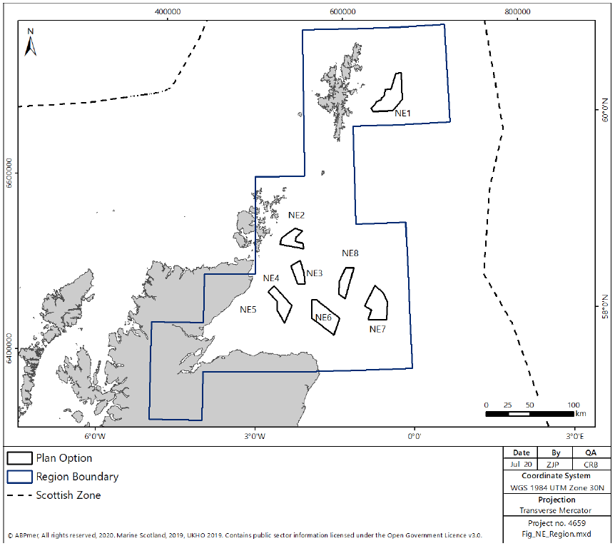
4.4 North East Region
The North East region encompasses seven PO areas (NE1, NE2, NE3, NE4, NE6, NE7 and NE8) (see Figure 14). Please note that DPO NE5 did not progress as a final PO and has been removed. The key risk factors to development within the North East region are:
- risks to bird species, including collision risk and displacement, as well as potential impacts to birds on migratory pathways;
- potential impacts on commercial fishing;
- potential impacts on marine mammal receptors;
- potential impacts on migratory fish species;
- potential impacts on benthic habitat and species; and
- potential cost impacts and associated navigational risk from diverting key commercial shipping routes;
Within the North East region, there is already significant offshore wind development, principally in the Moray Firth, adjacent to PO NE4, including;
- Beatrice offshore wind farm (588 MW, operational);
- Moray East offshore wind farm (950 MW. in construction); and
- Moray West offshore wind farm (850 MW, consented).
Additionally, there are current marine renewable energy developments in the Orkney and Shetland Islands (including wave and tidal devices deployed as part of EMEC and the Nova Innovation Shetland Tidal Array) which would need to be considered in any in-combination assessments.
Within the North East region, development across multiple POs could result in significant cumulative collision risk and displacement impacts on key seabird species. These concerns are detailed in full in the HRA Report and the Appropriate Assessment. POs NE2, NE3, NE4, and NE6 are therefore classed as being subject to 'higher levels of ornithological constraint' and require that sufficient scientific evidence, which reduces the level of risk to an acceptable level, is made available. This may, therefore, delay the progression of licence and consent determinations within these POs, until such time that further evidence, research and knowledge around mitigation is available to support decision-making in this region. This is discussed in greater detail at section 5.3.
Potentially significant effects on marine mammals could occur during construction activities and further consideration of these impacts would be required at a project-level. In addition, potential cumulative impacts on navigation would need to be considered as a result of development of large areas within the POs and these impacts would need to be considered and addressed at a project-level.
There are some areas of overlap with existing oil and gas infrastructure, licensed blocks for oil and gas production and round awards for oil and gas exploration. Further, some POs are located inshore of existing and potential oil and gas production areas. There are some areas of overlap with areas awarded under the 29th and 30th oil and gas leasing rounds, however, it is anticipated that activity will have lapsed or concluded prior to offshore wind development commencing.
Where there are areas of spatial overlap, it is assumed that renewable energy development will not be permitted within a given corridor either side of the pipeline/platform (to facilitate maintenance activity and access to said structures, until such time as any structure(s) are decommissioned). It is also assumed that the cost of any required cable/pipeline crossings with existing infrastructure will be borne by the offshore wind developer.
Further consultation would be required with the oil and gas industry regarding potential interactions between these two sectors.
Projects considering possible connections to oil and gas platforms or infrastructure should also note section 2.5 regarding the possibility of a future leasing round to support oil and gas decarbonisation. Although any such future leasing round may specifically target projects exploring oil and gas decarbonisation, projects progressing under this cycle of ScotWind leasing may also utilise these types of connections, as long as the project site is located within a PO.
Diadromous fish, particularly Atlantic Salmon, are likely to be present within the PO in this region. Although the exact location of migration routes or connectivity to specific rivers is not known, mitigation at the project-level may be required to avoid potential negative impacts.
The POs in the North East overlap with widespread commercial fishing effort. Whilst effort has been taken to avoid overlap, there remains the potential for negative impact through the loss of fishing grounds in this region. This is due, in part, to the number of PO in this region and the level of commercial fishing activity in the north east of Scotland. The Scottish Fishermen's Federation ("SFF") and the Scottish White Fish Producer's Association ("SWFPA") both responded to the consultation on the draft Plan and suggested areas within a number of the DPOs which could facilitate co-existence between both sectors. Developers bringing projects forward inside these POs should consider these suggestions when formulating their proposals and early and sustained consultation with the commercial fishing sector is recommended.
Following consideration of the feedback received during the consultation period, it should be noted that DPO NE5 has not been taken forward for inclusion as a PO due to the potential cumulative impacts on commercial fishing in this region. Further information regarding its removal is outlined above at section 2.2 and in the PAS.
4.4.1 NE1
NE1 covers a total area of 751 km2 and offers a potential maximum realistic development scenario of up to 2 GW of generating capacity (equating to 53% of the total area of the DPO). The water depth across the PO is deep throughout (> 100 m).
The SEIA identifies some potential for significant cost impacts associated with the loss of fishing grounds in NE1. Key gear types in NE1 are demersal trawls and mechanical dredges which are likely to be excluded from the footprint of any offshore wind development. Areas within NE1 may be important fish spawning grounds, including for herring, cod and whiting and these risks would need to be addressed by project-level mitigation measures.
Consultation will be required with the MOD regarding potential radar interference from turbines in NE1.
The SEA identifies that NE1 lies adjacent to the Pobie Bank SAC, designated for benthic habitats, therefore, some examples of these benthic features could be present with the PO. Benthic survey and spatial planning within the PO will be required to mitigate any potential impacts, including potential impacts associated with sediment smothering or increased scour associated with turbine foundations.
Whilst NE1 is fully located outwith the territorial waters surrounding Shetland (12 NM), regular, large vessels landing at Sullom Voe regularly use the area to anchor and wait for access. This project level mitigation may be required to avoid unnecessary impacts resulting from the potential overlap.
4.4.2 NE2
NE2 covers a total area of 345 km2 and offers a potential maximum realistic development scenario of up to 1 GW of generating capacity (equating to 58% of the total area of the PO). The water depth across the PO is between 60 m and 100 m throughout.
Key potential cost impacts arising from development in NE2 are to commercial shipping and power interconnector sectors (due to diversion of routes), which could be mitigated at a project-level.
The SEA and HRA identify that NE2 may be important as a foraging area for kittiwake and concerns regarding potential in-combination impacts has resulted in this PO as being classified as being 'subject to higher levels of ornithological constraint', see further, section 5.3.
There is potential for important fish spawning grounds, including those for herring, to be located within NE2. Risks to spawning fish (mainly related to piling noise) would need to be addressed via project-level mitigation.
4.4.3 NE3
NE3 covers a total area of 265 km2 with a potential maximum realistic development of up to 1 GW of generating capacity (equating to 76% of the total area of the PO). The water depth across the PO is between 60 m and 100 m throughout.
The SEIA identifies costs to commercial shipping and fishing sectors, both of which are low when considered over the lifetime of a development and would need to be considered at a project-level. There is also potential, however, for development in NE3 to have consequences for navigational safety, due to proximity to key shipping routes, which will require consideration and management in project level assessment.
Consultation would be required with the MOD regarding potential radar interference from turbines in NE3.
The SEA and HRA identify that NE3 may be important as a foraging area for seabirds, and concerns regarding potential in-combination impacts has resulted in this DPO as being classified as being 'subject to higher levels of ornithological constraint'. See further, section 5.3.
There is potential for areas within NE3 to be important fish spawning grounds, including for herring. Risks to spawning fish would need to be addressed by project-level mitigation.
4.4.4 NE4
NE4 covers a total area of 440 km2 and offers a potential maximum realistic development of up to 1 GW of generating capacity (equating to 45% of the total area of the PO). The water depth across the PO is predominantly shallow (<60 m) throughout, with small areas of deeper water (60-100 m) in the south of the PO.
The SEIA identifies generally lower socio-economic costs arising from potential offshore wind development within NE4. The only identified costs are to commercial shipping and fishing sectors, both of which are low when considered over the lifetime of a development. There is also potential for development in NE4 to have significant consequences for navigational safety, due to a large overlap with the key shipping route around the Scottish coastline. This will require significant consideration and management in project-level assessment, as these effects are unlikely to be avoidable, due to the high density of traffic throughout the PO.
Consultation will be required with the MOD regarding potential radar interference from turbines in NE4.
Similar to NE2 above, the SEA and HRA identify that NE4 is likely to be important as a foraging area for seabirds, including kittiwake from multiple SPA. As discussed above, concerns regarding potential in-combination impacts on key seabird species has resulted in this PO as being classified as being 'subject to higher levels of ornithological constraint'.
4.4.5 NE6
NE6 covers a total area of 669 km2 and offers potential maximum realistic development scenario of up to 2 GW of generating capacity (equating to 57% of the total area of the PO). The water depth across the PO is mostly 60 m to 100 m throughout with some areas of deeper water (> 100 m) in the south and west of the PO.
The SEIA identifies potential socio-economic impacts on the commercial shipping sector, including lifeline ferry services. There a high density of shipping activity in this area, therefore, potential for mitigating costs may be limited. Similarly, the SEA identifies potential risks to navigational safety, arising from the potential concentration of traffic into fewer, narrower routes either around, or within the PO. These impacts would need to be considered at a project-level.
Consultation would be required with the MOD regarding potential radar interference from turbines in NE6.
The SEA and HRA identify that NE6 may be important as a foraging area for seabirds, including kittiwake, and concerns regarding potential in-combination impacts has resulted in this PO as being classified as being 'subject to higher levels of ornithological constraint' (see further, section 5.3).
There is potential for areas within NE6 to be important fish spawning grounds, including for herring and sandeel. Risks to spawning fish would need to be considered at a project-level.
4.4.6 NE7
NE7 covers a total area of 684 km2 and offers a potential maximum realistic development scenario of up to 3 GW of generating capacity (equating to 88% of the total area of the PO). The water depth across the PO is generally deep throughout (> 100 m) with some areas of shallower depth (60 – 100 m).
The SEIA identifies potential for significant socio-economic cost impacts associated with the loss of fishing grounds arising from potential offshore wind farm development in NE7. Key gear types in NE7 are pelagic trawls and demersal trawls, which are likely to be excluded from the footprint of any offshore wind development.
Consultation would be required with the MOD regarding potential radar interference from turbines in NE7.
The SEA identifies that NE7 has the potential to affect bird species, although the distance offshore reduces the potential risk to birds foraging in this area. There may, however, also be species which transit through these offshore areas as part of migration routes, and therefore project-level survey and consideration of potential mitigation measures would be required.
4.4.7 NE8
NE8 covers a total area of 339 km2 and offers a potential maximum realistic development scenario of up to 1 GW of generating capacity (equating to 59% of the total area of the PO). The water depth across the PO is generally deeper throughout with a combination of areas of 60 m to 100 m and areas greater than 100 m water depth.
The SEIA identifies potential for significant socio-economic cost impacts associated with the loss of fishing grounds in NE8, which is the most intensively fished PO under consideration. Key gear types in NE8 are midwater trawls which are likely to be excluded from the footprint of any offshore wind development.
Consultation would be required with the MOD regarding potential radar interference from turbines in NE8.
The SEA identifies that NE8 has the potential to affect bird species, although the distance offshore reduces the potential risk to foraging areas. There may, however, be species which transit through these offshore areas as part of migration routes, and therefore project-level survey and consideration of potential mitigation will be required.
4.4.8 Key actions for the North East region
As discussed further in section 5.3.1, POs NE2, NE3, NE4, and NE6 have been classed as being 'subject to high levels of ornithological constraint'. It is proposed, therefore, that development will only be able to progress at these POs where sufficient scientific evidence can be provided to reduce the risk to an acceptable level (unless it can be determined that there are imperative reasons of overriding public interest that require development to proceed).
In addition to the requirements regarding NE2, NE3, NE4 and NE6, and in order to progress development in the North East region, the following (non-exhaustive) key steps are likely to form part of the development process. It is recognised that some steps will be more applicable to specific POs within the NE region:
- consultation with local stakeholders regarding landscape and seascape;
- pre- and post-consent, and post-construction, bird monitoring;
- consultation with the fishing community;
- benthic survey and subsequent spatial planning to avoid any key habitats identified;
- consultation with the fishing community;
- consultation with the MOD;
- consultation with the oil and gas industry; and
- consultation with the Maritime and Coastguard Agency.
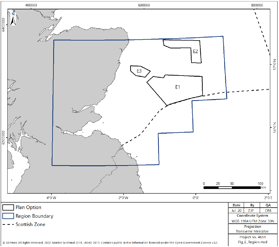
4.5 East region
The East region encompasses three POs (E1, E2 and E3) (as shown in Figure 15). The key risk factors to development within the East region are:
- risks to bird species, including collision risk and displacement, as well as potential impacts to birds on migratory pathways
- potential impacts on marine mammal receptors;
- potential impacts on benthic habitat and species;
- potential impacts on migratory fish species;
- potential cost impacts and associated navigational risk from diverting key commercial shipping routes; and
- potential impacts on commercial fishing.
Within the East region, there is already significant offshore wind development, inshore of the proposed POs, including the following operational and consented projects:
- Forthwind Offshore Windfarm (29.9 MW consented);
- Levenmouth Demonstration Turbine (7 MW operational);
- European Offshore Wind Deployment Centre (93 MW operational);
- Inch Cape (700 MW consented);
- Kincardine Offshore Windfarm (50 MW consented, partially operational (1 turbine));
- Neart na Gaoithe (450 MW consented);
- Hywind Scotland Pilot Park (30 MW operational); and
- Seagreen Alpha and Bravo (1050 MW consented).
In addition, Seagreen Berwick Bank (2300 MW) and Marr Bank (between 900 and 1850 MW)[36] (previously known as Seagreen Charlie and Delta/Phases 2 and 3) were previously scoped and these projects would need to be considered in any in-combination assessment.
Within the East region a key pathway of concern relates to effects on bird populations, due to potential in-combination impacts resulting from collision risk and displacement for key seabird species. These concerns are detailed in full in the HRA report and PO E3 is therefore classed as being subject to 'high levels of ornithological constraint' (as set out at section 5.3.1). It is proposed, therefore, that development will only be able to progress at POs NE2, NE3, NE4, NE6 and E3 where sufficient scientific evidence can be provided to reduce the risk to an acceptable level (unless it can be determined that there are imperative reasons of overriding public interest that require development to proceed).
Diadromous fish, particularly Atlantic Salmon, are likely to be present within the PO in this region. Although the exact location of migration routes or connectivity to specific rivers is not known, mitigation at the project-level may be required to avoid potential negative impacts.
In addition, the HRA report identifies that there are concerns regarding the scale of the potential in-combination impacts on key seabird species from development at POs E1 and E2. Therefore, further regional survey effort and discussion will be required (as outlined in section 5.3.2) before development can progress in these POs.
Potentially significant effects on marine mammals could occur during construction activities, and further consideration of potential impacts and mitigation measures will be required at a project-level.
As per the North East region, there is the potential for some overlap and/or interaction between the POs and areas licensed and/or leased for oil and gas production or exploration. Further consultation would be required with the oil and gas industry regarding potential interactions.
4.5.1 E1
E1 covers a total area of 3744 km2 and offers a potential maximum realistic development scenario of up to 3 GW of generating capacity (equating to 16% of the total area of the PO). The water depth across the PO is between 60 m and 100 m throughout.
The SEIA identifies minor socio-economic cost impacts arising from potential development in E1 to commercial shipping, fishing and power interconnector sectors, which would need to be considered at a project-level.
Consultation would be required with the MOD regarding potential radar interference from turbines in E1.
The SEA and HRA identifies that E1 may be important as a foraging area for kittiwake and razorbill and therefore, due to the concerns regarding potential in-combination impacts, further regional survey effort and consultation would be required.
There is potential for areas within E1 to be important fish spawning grounds, including for herring, cod, whiting, plaice and sandeel. Risks to spawning fish would need to be considered and mitigated at a project-level.
4.5.2 E2
E2 covers a total area of 1287 km2 and offers a potential maximum realistic development of up to 2 GW of generating capacity (equating to 31% of the total area of the PO). The water depth across the PO is between 60 m and 100 m throughout.
The SEIA identifies minor socio-economic cost impacts arising from potential development in E2 to commercial shipping and fishing sectors.
Consultation would be required with the MOD regarding potential radar interference from turbines in E2.
The SEA and HRA identifies that E2 may be important as a foraging area for kittiwake and razorbill and therefore, due to the concerns regarding potential in-combination impacts, further regional survey effort and consultation would be required.
There is potential for areas within E2 to be important fish spawning grounds, including for herring, cod, whiting, plaice and sandeel. Risks to spawning fish would need to be considered and mitigated at a project-level.
4.5.3 E3
E3 covers a total area of 474 km2 and offers a potential maximum realistic development of up to 1 GW of generating capacity (equating to 42% of the total area of the PO). The water depth across the PO varies, incorporating area of shallow water (0-60 m), and deeper water (both 60 – 100 m and > 100 m).
The SEIA identifies minor socio-economic cost impacts for the commercial shipping, fishing and power interconnector sectors, which would need to be considered and mitigated at a project-level.
Consultation would be required with the MOD regarding potential radar interference from turbines in E3.
The SEA and HRA identify that E3 may be important as a foraging area for kittiwake from designated SPA sites, As discussed above, concerns regarding potential in-combination impacts on key seabird species has resulted in this PO as being classified as being subject to 'higher levels of ornithological constraint'.
There is potential for areas within E3 to be important fish spawning grounds, including for herring, cod, whiting, plaice and sandeel. Risks to spawning fish would need to be mitigated at a project-level.
4.5.4 Key actions for the East region
As discussed below in section 5.3.1, E3 has been classed as a PO subject to 'high levels of ornithological constraint'. It is proposed, therefore, that development will only be able to progress at PO E3 where sufficient scientific evidence can be provided to reduce the risk to an acceptable level (unless it can be determined that there are imperative reasons of overriding public interest that require development to proceed). As outlined at section 5.3.2, POs E1 and E2 would require the completion of further regional-level survey effort before development can proceed.
In addition to the requirements above and in order to progress development in the East region, the following (non-exhaustive) key steps are likely to form part of the development process. It is recognised that some steps will be more applicable to specific POs within the region:
- consultation with local stakeholders regarding landscape and seascape concerns;
- completion of regional-level ornithological surveys in POs E1 and E2;
- pre- and post-consent, and post-construction, bird monitoring;
- benthic survey and subsequent spatial planning to avoid any key habitats identified;
- consultation with the commercial fishing community;
- consultation with the oil and gas industry; and
- consultation with the Maritime and Coastguard Agency.
4.6 South West region
Within the draft Plan, one DPO was identified in the South West region (SW1), located in the outer Solway Firth
Previous proposals for development within this region (in 2011 and 2013) were subject to strong and sustained opposition as a result of potential negative seascape, landscape and visual impacts, as well as negative socio-economic impacts relating to commercial fishing, tourism and recreation. This led Scottish Ministers to conclude that the Solway Firth and Wigtown Bay sites included in the 2011 Plan were unsuitable for the development of offshore wind and should not be progressed at that time.
These issues regarding socio-economic impact and seascape, landscape and visual impacts were reiterated by local communities and stakeholders during the consultation on the draft Plan, with over 300 respondents strongly opposing the inclusion of a DPO in this region. Concerns regarding the potential level of socio-economic benefit which would, in fact, accrue to the local community as a result of any development, due to the nature of the local supply chain and ports, were also raised. Respondents raised concerns regarding potential negative impacts on migratory bird species and cumulative impacts on sensitive coastal, landscape and visual receptors as a result of existing onshore wind farms and the Robin Rigg development. The SA noted many of these issues and additional key risk factors, as described in the draft Plan.
The SEIA specifically identified that retention of spend in the South West region would be likely to be limited due to supply chain capacity, although some growth has been anticipated by the end of the assessment timeframe. Positive economic impacts would be expected to be concentrated in Ayr, due to the existing facilities, although impacts on fish landings would also be expected to be greatest at Ayr (the SEIA considered that the overall effects in terms of loss of jobs would be low). Negative impacts from changes to seascapes or displacement of tourism and recreational activities, however, would be more likely to occur along the southern coast of Dumfries and Galloway, so these communities could perceive that they may incur negative impacts without, necessarily, experiencing any direct economic positive effects from the level of spend.
NatureScot has provided detailed Supplementary Advice, in addition to its consultation response, regarding potential seascape, landscape and visual impacts of the DPOs and associated design guidance.[37] In its Supplementary Advice, it stated that, "we advise that any scale of turbine will introduce significant cumulative day and night-time effects", due to the small scale of the site and its proximity to the coastline. NatureScot highlights that a project-level design solution and site specific mitigation for development within this DPO would have to be considered and assessed.
Following consideration of the assessment contained within the SA and the views submitted during consultation, Scottish Ministers have chosen not to progress SW1 as a PO at this time. In the event that future work is undertaken to address the estimated negative impacts (for example, through mitigation measures or planned securing of satisfactory benefits), this could support future discussion regarding the introduction of POs in the South West region within future iterations of the Plan.
Such future information could include, for example, detailed supply chain and socio-economic analysis and local engagement to explore issues and identify possible solutions. Any such measures would need to be aimed at addressing the significant adverse impacts of the development, but could also include the identification of potential socio-economic benefit for local communities and the regional economy to mitigate potential negative impacts relating to the fishing, tourism and recreation sectors, via scenario-mapping exercises or similar.
The iterative plan review process outlines the circumstances in which new information or data may be submitted and assessed to help facilitate updates or reviews of the Plan (see section 6). As with other evidence or information submitted, in the event that efforts are made to address these impacts, taking account of the specific issues relating to SW1 and the South West region (for example, a comprehensive assessment and demonstration of deliverable positive social and economic benefits, supported by evidence of significant engagement with the relevant sectors and including statements regarding potential socio-economic benefits relied upon which are suitably evidenced), then Scottish Ministers may consider whether constraints have been satisfactorily addressed to allow future consideration of offshore wind development in this region. This could be addressed through the scheduled review process (e.g. year 2) or earlier if relevant evidence arises. Any change of this nature to the Plan would require further assessment and consultation to be undertaken, before approval by the Scottish Ministers.