Sectoral marine plan for offshore wind energy
Aims to identify sustainable plan options for the future development of commercial-scale offshore wind energy in Scotland, including deep water wind technologies, and covers both Scottish inshore and offshore waters.
3. Plan development process and assessment of potential impacts
The sectoral marine planning process (as shown in Figure 6) is an iterative process, informed through stakeholder engagement and evidence from the related social, economic and environmental assessments. All of the information and consultation feedback gathered throughout the planning process has been used to support the Scottish Ministers in identifying the Plan Options and policies included in this Plan.
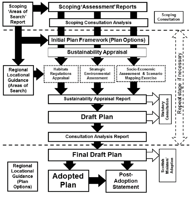
This process ensures delivery of the necessary environmental and socio-economic assessments required to ensure compliance with our statutory duties. Furthermore, the process enables active and regular engagement with key stakeholders throughout the process, as well as through specific consultation exercises.
3.1 Key planning stages
The key stages of the planning process in relation to the identification of the Draft Plan Options are:
1. Opportunity and Constraint Analysis – Iteration 1
2. Opportunity and Constraint Analysis – Iteration 2 - Single Issue Constraint Analysis
3. Scoping Consultation
4. Opportunity and Constraint Analysis – Iteration 3
5. Identification of Draft Plan Options
6. Assessment of Draft Plan Options
7. Consultation on Draft Plan Options
8. Finalisation and adoption of the Plan
9. Next Steps
1. Opportunity and Constraint Analysis – Iteration 1
The identification of initial Areas of Search ("AoS") was carried out through the use of an Opportunity and Constraint ("O&C") analysis.[15] It built upon previous work carried out by Marine Scotland Science ("MSS") in 2011[16] and the production of draft Regional Locational Guidance for potential deep water floating offshore wind test sites in 2014.[17] The analysis was iterative, so updates could be incorporated as required in order to reflect stakeholder feedback.
Full details of the O&C analysis can be found in the AoS scoping report published for consultation in 2018.[18] The O&C analysis sought to identify areas of opportunity for the future development of offshore wind, whilst also identifying areas that minimised potential negative impacts to the environment, other sectors and users of the sea. This analysis was completed through the use of GIS and numerous spatial data resources.
2. Opportunity and Constraint Analysis – Iteration 2
Sectoral engagement workshops were held in spring 2018. The AoS were then refined with consideration to specific spatial issues and feedback from the workshops.
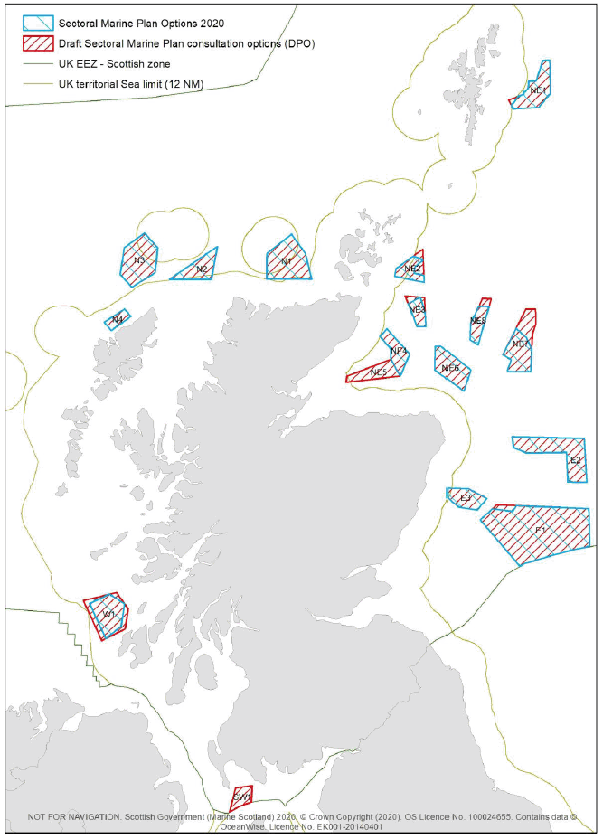
This refinement process identified a range of distinct AoS (see Figure 7). As the draft Plan is technology neutral, no commercial or technology specific information was used in this refinement process
3. Scoping Consultation – Screening and Scoping Reports
Scottish Ministers then consulted on the screening and scoping stages of the Plan process during June and July 2018. Screening and scoping reports were prepared and published online for the SEA, HRA and SEIA alongside the AoS scoping study[19].
4. Opportunity and Constraint Analysis – Iteration 3
Iteration 3 of the O&C analysis was undertaken, which considered the responses received during the Scoping Consultation, for more details see the Consultation Analysis Report.[20]
The AoS were refined with consideration to the outputs of the Iteration 3 O&C Analysis. As a result, certain AoS were either removed or refined to avoid/incorporate certain areas of Scottish Waters.
This stage also considered the areas of seabed proposed by stakeholders via the scoping consultation. A number of the areas proposed overlapped with existing AoS, while others overlapped with areas with higher levels of constraint or entirely new areas.
Upon review of the above information, a number of areas were identified to move forward in the plan process. Accordingly, some additional areas were included at this stage, where there was significant stakeholder interest, but also increased constraint. The Sustainability Appraisal stage assessed these new areas in greater detail.
5. Identification of Draft Plan Options
The 22 revised AoS were made available to the Sectoral Marine Plan Project Board and two Project Steering Groups for consideration and comment.[21]
Responses from both the Board and Steering Groups, together with the outputs of the initial assessments, was presented to Scottish Ministers to inform their decision on which AoS should progress to the Sustainability Appraisal for more detailed assessment. 17 revised AoS were selected as DPOs.

6. Assessment of Draft Plan Options
The DPOs identified have been subject to Strategic Environmental Assessment (SEA), Habitats Regulations Appraisal (HRA) and Socio-Economic Assessment with reports produced to summarise these.[22]
The assessments completed on the Draft Plan were included within the consultation discussed below.
7. Consultation on Draft Plan Options
Statutory consultation was held on the draft Plan and Sustainability Appraisal for a period of 14 weeks between 18 December 2019 and 25 March 2020. To support the consultation process, a total of 17 events were held during February and March 2020 were held in coastal communities across Scotland during February and March 2020.
A total of 443 consultation responses were received and the responses received have been analysed to produce the Consultation Analysis Report (June 2020).[23] Where permission has been granted, copies of submitted responses have been published online.[24]
8. Finalisation of Plan
An analysis of the responses received was used to inform the Scottish Ministers' decision on which Draft Plan Options to progress. The Post Adoption Statement published in conjunction with this Plan details the changes made to the draft Plan as a result of consultation feedback. Figure 8 details the changes between draft and final Plan Options.
In addition to the production of the Final Plan, the following documents have been updated and finalised;
- Final Regional Location Guidance;
- Post Adoption Statement;
- Appropriate Assessment;
- Final Islands Communities Impact Assessment; and
- Final Equalities Impact Assessment.
9. Next Steps
Within one month of the publication of this Plan, CES will publish a Post Adoption Addendum, detailing the implications of any differences between the draft and final Plans for their leasing regime. The application window for Option Agreements will close thereafter.
The Plan will guide the relevant consenting bodies when making decisions on individual licence and consent applications, but should not be considered as pre-determining those decision-making processes.
After adoption of the Plan, applicants will prepare their licensing and consenting applications. If successful in obtaining the necessary consents and licences and if the conditions of their Option Agreements have been fulfilled applicants may then choose to proceed to an Agreement for Lease with CES, which enables construction to commence. The standard project development process is outlined in Figure 9 below and further information about the marine licensing and consenting process and project-level assessment is included at section 5.1.2.
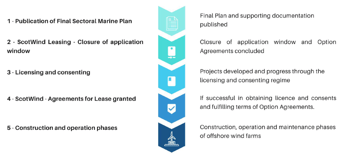
1. Publication of Final Sectoral Marine Plan
- Final Plan and supporting documentation published
2. ScotWind Leasing – closure of application window
- Closure of application window and Option Agreements concluded
3. Licensing and consenting
- Projects developed and progress through the licensing and consenting regime
4. ScotWind – Agreements for Lease granted
- If successful in obtaining licence and consents and fulfilling terms of Options Agreements.
5. Construction and operations phases
- Construction, operation and maintenance phases of offshore wind farms
3.2 Sustainability Appraisal
Sustainability Appraisal ("SA") was undertaken on the 17 DPOs, comprising of a Strategic Environmental Assessment ("SEA"), Habitats Regulations Appraisal ("HRA") and Social and Economic Impact Assessment ("SEIA"). The findings of the SA are set out in the individual SEA, HRA and SEIA reports and summarised in the overall SA report. These reports, and the draft Regional Locational Guidance ("RLG"), were published for consultation in December 2019.[25]
The RLG has been updated to reflect the final POs. It provides baseline data used in the assessment process and supports further spatial planning and inform project-level site selection and assessment.
The modifications made to the POs and final Plan are minor and do not alter the significance of the impacts assessed in the SA, therefore, it is not necessary to undertake re-assessment and further consultation in respect of these minor modifications.
The assessments have been undertaken in accordance with the European Commission Directive and the Scottish requirements for Strategic Environmental Assessment,[26] the Habitats and Birds Directives[27] and the requirement to consider social and economic factors under the UK Marine and Coastal Access Act 2009, and in accordance with the methodology agreed by the two cross-sectoral Steering Groups (outlined in the Scoping documentation) and statutory consultees (as defined by the Environmental Assessment (Scotland) Act 2005).[28]
The likely significant effects during all phases of offshore wind development, including pre-construction (e.g. unexploded ordnance clearance ("UXO") and survey works), construction, operation and maintenance and decommissioning, have been considered. In order to complete the assessment of potential impacts, a number of underpinning assumptions have been made. These are set out in full in the various assessment reports but are summarised briefly at section 3.2.1 below.
3.2.1 Underpinning assumptions
The assessment was undertaken on a technology neutral basis, as it is unclear how quickly and to what extent deep water technologies will become cost competitive and, therefore, what the balance of deployed technologies may be. Whilst the precise nature of technology and construction method(s) etc. have implications for the scale and nature of potential impacts, it is not appropriate to make detailed assumptions about these within the assessments. The Plan identifies POs located in a range of water depths, but does not direct what type of technology or technologies should be deployed within them. Full details on the range of technologies and methods assessed were set out in the Scoping Context Report.[29]
The impacts of individual DPOs were assessed using a realistic maximum deployment scenario (in GW) for each DPO, which equated to a proportion of the overall area of the DPO. This proportion varies according to the size and conditions of the DPO and has been derived from known constraints on development, early indications as to likely developer interest and established infrastructure to support development during the plan timescale.
Development within POs, therefore, should not exceed the parameters assessed in the SA, e.g. meaning that operational development(s) within a PO should not exceed the maximum realistic development scenario for that PO (as outlined in Table 1 below). The regional scenarios presented have been used in the assessment to provide an indication of potential impacts, however, these regional scenarios will not be used to constrain potential levels of operational development within POs.
In addition, potential impacts have been assessed at regional and national levels using a range of overall deployment scenarios (3, 5 and 10 GW at a national level). This range of development scenarios has been used within the SEA, HRA and SEIA to assess a wide range of impacts and reflect the inherent uncertainty in carrying out strategic assessments and the possible scales of development within each DPO, regionally and nationally.
Scenarios were developed relating to the potential scale of development within each option area, taking account of the ambitions of the plan (maximum of 10 GW installed capacity) in order to feed into assessment processes so that the outcomes of assessments were realistic. These scenarios were used in both the SEA and the SEIA and ultimately allowed for some consideration of spatial planning within each PO area as a mitigation measure. Whilst these scenarios gave an indication of the potential scale of maximum development, consistent with the aspirations of the plan, these scenarios should not be taken as being an endorsement of projects up to this size within a PO, as further project level assessment and planning will be required to ensure avoidance of significant adverse effects. Some consideration of the potential constraints associated with the environmental, social and economic effects of developments is included within the SEA, SEIA, HRA and RLG reports.
A recent review of the density of offshore wind turbine layouts of recent European offshore wind projects indicated average deployment densities of between 4-6.5 MW/ km2,[30] and, therefore, an average deployment density of 5 MW/ km2 was used in the assessment. When this average deployment density is applied, it is estimated that approximately 2,000 km2 of seabed would need to be operationally developed to deliver up to 10 GW of generating capacity nationally.
Where a PO is now smaller in size than the DPO assessed, the realistic development scenario has not changed, i.e. the proportion of the PO area which could be utilised may increase. For example, NE2 has been reduced in size by 119 km2 (26%). The realistic development scenario for this PO remains 1 GW, but the maximum percentage of the area which could be developed has increased from 43% at DPO stage, to 58% at PO stage.
Implications of development scenarios for the first cycle of ScotWind Leasing
The SA determined that an overall national limit on generating capacity of 10 GW was required as a mitigation measure (on the basis of average deployment of 5MW/km2). The development scenarios outlined in the SA estimated that the operational development of approx. 2,000 km2 of seabed would be required in order to deliver up to 10 GW of generating capacity.
It is recognised, however, that due to the nature of the leasing and development processes and likely attrition rates,[31] CES will need to offer Option Agreements for an area of greater than 2,000 km2 to be likely to enable the operational development of up to 10 GW of generating capacity.
Making an area of up to 8,600 km2 of seabed available for Option Agreements via the first cycle of ScotWind leasing could, therefore, support the development of projects capable of delivering up to 10 GW of total generating capacity.[32]
Nationally and at the individual PO level, the effects of consented and licensed offshore windfarm development under this cycle of leasing should not exceed the assumed physical footprint for 10GW of generation as assessed in this Plan of approx. 2,000 km2 of seabed. It is acknowledged that as technology matures facilitating more efficient use of the seabed, over the life of the Plan, the average deployment density may increase and the same physical footprint may be capable of delivering more than 10 GW in the future.
The ScotWind leasing round documentation[33] sets out how this has been applied at the Option Agreement stage for the purpose of lease applications. A Post-adoption Addendum to these documents will be published by CES following adoption of this Plan. This will address any changes between the draft and final Plan.
Figure 10 Implications of development scenarios for the first cycle of ScotWind Leasing
| Region | DPO | Total DPO Area (km²) | Realistic maximum development scenario for DPO (GW) | Realistic development as percentage of total DPO Area | Regional Low Scenario (GW) | Regional Medium Scenario (GW) | Regional High Scenario (GW) |
|---|---|---|---|---|---|---|---|
| East | E1 | 3742 | 3 | 16% | |||
| E2 | 1287 | 2 | 31% | ||||
| E3 | 474 | 1 | 42% | ||||
| Sub-total | 5503 | 6 | 1 | 2 | 3 | ||
| North East | NE1 | 751 | 2 | 53% | |||
| NE2 | 345 | 1 | 58% | ||||
| NE3 | 265 | 1 | 76% | ||||
| NE4 | 440 | 1 | 45% | ||||
| NE6 | 699 | 2 | 57% | ||||
| NE7 | 684 | 3 | 88% | ||||
| NE8 | 339 | 1 | 59% | ||||
| Sub-total | 3523 | 11 | 1.5 | 3 | 4.5 | ||
| North | N1 | 1163 | 2 | 34% | |||
| N2 | 561 | 2 | 71% | ||||
| N3 | 1106 | 2 | 36% | ||||
| N4 | 200 | 1 | 100% | ||||
| Sub-total | 3030 | 7 | 1 | 2 | 3 | ||
| West | W1 | 754 | 2 | 53% | |||
| Sub-total | 754 | 2 | 0.5 | 1 | 2 | ||
| Total: | 12810 | 26 | 4.3 | 8.6 | 13.5 | ||
| Scaled back to national scenarios (GW): | 3 | 5 | 10 | ||||
3.2.2 Strategic Environmental Assessment ("SEA")
SEA is intended to increase the consideration of environmental issues during decision-making related to strategic documents such as plans, programmes and strategies. For the Plan, it has been used to test and comment on the selection of POs from a strategic perspective and to identify potential strategic environmental constraints, in order to steer future development. The process is applicable to strategic and, to some extent, regional issues.
As a result, the SEA findings have led to broad recommendations for the Plan as a whole. The findings can also, where appropriate, be used as a starting point for further, detailed, data collection and environmental assessment – either to support strategic level review or for project-level assessment. A summary of the key findings for each PO are set out in section 4.
The SEA is available here: http://www.gov.scot/ISBN/9781839603761
3.2.3 Habitats Regulations Appraisal ("HRA")
It was identified at the pre-screening stage that a HRA would be required, as the possibility of likely significant effects on European site(s) from the Plan could not be excluded (either as a result of development within a DPO in isolation or in-combination with other plans or projects). Details of the HRA screening process are included in the Sectoral Marine Plan for Offshore Wind Energy: Strategic Habitat Regulations Appraisal Pre-Screening Report.[34]
The HRA included consideration of impacts on Special Areas of Conservation ("SAC"), candidate and possible SAC ("cSAC and pSAC"), Special Protected Areas ("SPA"), proposed SPA ("pSPA"), Sites of Community Importance ("SCI") and Ramsar sites (listed under the Ramsar Convention on Wetlands of International Importance). The HRA has been undertaken for all DPOs within the draft Plan and has resulted in the implementation of plan-level mitigation measures to avoid potential adverse impacts on site integrity, as well as recommendations for project-level mitigation measures. A summary of the key findings for each PO are set out in section 4. An Appropriate Assessment has been undertaken for the Plan Options included in the final Plan.
The HRA is available here: http://www.gov.scot/ISBN/9781839603754
3.2.4 Socio-Economic Impact Assessment ("SEIA")
The SEIA has considered the potential negative and positive social and economic impacts of the Plan on a range of sectors. Due to uncertainties regarding the potential scale of development within any Plan Option, regionally or nationally, assessment has been undertaken for a range of deployment scenarios (ranging from low-medium-high), which have been compared to the do nothing approach. The SEIA has also been undertaken on a worst case scenario basis where appropriate, given the uncertainty around development and technology types at a plan level. More detailed project-level assessment will be required accordingly.
The SEIA identified that DPOs are most likely to have negative impacts on the commercial fisheries, commercial shipping, tourism and recreation sectors. The SEIA also identified that development may also have impacts for other sectors (such as the defence and aviation sectors). The SEIA therefore identified a range of possible project-level mitigation measures, such as; adherence to Maritime and Coastguard Agency guidance regarding shipping lanes, spatial planning within DPOs to avoid areas of higher fishing activity, maintaining access to recreational fishing grounds within arrays or reduction in turbine sizes to minimise landscape, seascape and visual impacts. Positive impacts in relation to Gross Value Added and employment, including social impacts, were also assessed in the SEIA. A summary of the key findings for each PO are set out in section 4.
The SEIA is available here: http://www.gov.scot/ISBN/9781839603792
3.2.5 Sustainability Appraisal ("SA")
SA is a tool to undertake cross-sectoral assessment of the impacts of plans in order to promote sustainable development and has been an integral part of every stage of the planning process. The SA has contributed to the Scottish Ministers' decision-making process and the SA report provides an overview of the conclusions of the component reports (i.e. SEA, HRA and SEIA).
The SA is available here: http://www.gov.scot/ISBN/9781839603785
3.2.6 Islands Communities Impact Assessment and Equalities Impact Assessments
Draft partial Islands Communities Impact ("ICIA") and Equalities Impact Assessments ("EQIA") were prepared to consider how the draft Plan could impact island communities and equalities considerations. These partial assessments formed part of the consultation process and comments received were used to refine and produce the final ICIA and EQIA records for this Plan.
The comments received did not identify any additional impacts which needed to be considered. Responses reiterated the need for early and sustained engagement with potentially affected communities.
3.3 Consultation Analysis Reports
Extensive stakeholder consultation has been undertaken throughout the planning process to support identification of POs and the development of the Plan.
During June to July 2018, a consultation exercise on the Scoping Areas of Search and supporting screening and scoping reports was undertaken and the feedback used to further refine the O&C model and identification of revised AoS. Further stakeholder engagement was undertaken post-scoping to support the identification and development of DPOs. The consultation analysis report for this consultation exercise provides a summary of the feedback received during the scoping and post-scoping periods.
The consultation analysis report for pre and post scoping stages is available here: https://consult.gov.scot/marine-scotland/draft-sectoral-marine-plan-for-offshore-wind/
A further consultation analysis report has been prepared for the statutory consultation on the draft Plan and SA, which ran for a period of 14 weeks from 18 December 2019 to 25 March 2020 (as detailed above). The Consultation Analysis Report also provides summarises of the consultation events which were held during February and March 2020 and is available here:
In addition, copies of submitted responses (where respondents have indicated that they approve to their publication) can be viewed and downloaded via the Scottish Government's Consultation Hub here:
https://consult.gov.scot/marine-scotland/draft-sectoral-marine-plan-for-offshore-wind/
3.4 Post Adoption Statement
In addition to the impact assessments described above, A Post Adoption Statement ("PAS") is published alongside this Plan. The PAS provides further detail regarding action taken in the final Plan to address consultation comments, including amendments made to the DPOs to arrive at final POs. The PAS delivers on the requirements of the Strategic Environmental Assessment Directive (as implemented by the Environmental Assessment (Scotland) Act 2005). The PAS is available here: