Scottish Vacant and Derelict Land Survey 2019
Data collection undertaken to establish the extent and state of vacant and derelict land in Scotland. The data is sourced from local authorities and the Loch Lomond and Trossachs National Park Authority.
Part of
8. Derelict Land: People’s Proximity to Derelict Land
8.1 This section focuses exclusively on derelict land and people’s proximity to such sites throughout Scotland. It reports on people’s proximity to derelict land and not their exposure to it.
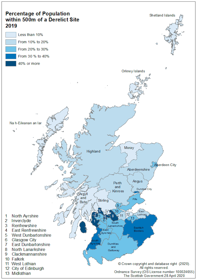
8.2 28.4% of Scotland’s population is estimated to live within 500 metres of a derelict site. A further 24.0% are estimated to live between 500 metres and 1,000 metres of a derelict site with the remaining 47.6% living at least 1,000 metres from a derelict site (Table 9).
8.3 People’s proximity to derelict land varies significantly by authority. For example, 54.7% of Glasgow City’s population is estimated to live within 500 metres of a derelict site, whereas the figure for City of Edinburgh is 7.3%. The councils with the highest proportion of their population living within 500m of derelict land are North Lanarkshire (75.2%), Inverclyde (57.5%) and West Dunbartonshire (57.3%). The populations of the Orkney Islands and Shetland Islands are least likely to be living close to derelict land, both with less than 1% of their population estimated to live within 500 metres of a derelict site.
8.4 In 2013, an estimated 29.7% of Scotland’s population lived within 500 metres of a derelict site. This has decreased slightly to 28.4% in 2019 (Table 10).
8.5 The notable decrease recorded in Orkney in 2014 is due to the removal of eight sites, seven for definitional reasons and one for retail development.
8.6 The increase recorded in Inverclyde in 2016 is due to the addition of three new sites all close to residential areas and changes made to site types for several older (pre 2001) sites from vacant to derelict as well as increases in the size of some older sites. The increase in Dumfries and Galloway in 2017 is due to the addition of 16 new derelict sites.
8.7 From 2013, long term derelict sites are considered to be those recorded as derelict prior to 2001. For the years 2013 to 2019 the percentage of Scotland’s population that were estimated to live within 500 metres of a site that was derelict prior to 2001 fell each year, falling by two percentage points from 2013 to 2019, 16.4% to 14.4%.
8.8 People’s proximity to long term derelict land varies significantly by authority. Those councils with the largest percentage of people within 500 metres of a long term derelict site are West Dunbartonshire (37.8%), Glasgow City (36.7%), Inverclyde (33.3%) and North Lanarkshire (32.9%).
8.9 Eight local authorities show an increase in population estimated to live within 500 metres of a site that was derelict prior to 2001 compared to the previous year, five of these are very small increases of only up to 0.2 percentage points. Increases in proximity to pre- 2001 sites are usually caused either by the entry of newly identified sites that have been derelict for a long time, or where old sites change type from vacant to derelict. New residential developments also have an effect.
| Local Authority | Population2 | Distance from Derelict Land in 20193 | ||
|---|---|---|---|---|
| Less than 500m | 500m to Less than 1,000m | 1,000m or further | ||
| Aberdeen City | 227,560 | 23.5 | 21.7 | 54.8 |
| Aberdeenshire | 261,470 | 10.5 | 12.8 | 76.7 |
| Angus | 116,040 | 18.3 | 22.0 | 59.7 |
| Argyll and Bute | 86,260 | 8.5 | 9.6 | 81.9 |
| Clackmannanshire | 51,400 | 27.5 | 34.3 | 38.2 |
| Dumfries and Galloway | 148,790 | 21.4 | 21.2 | 57.5 |
| Dundee City | 148,750 | 31.1 | 41.0 | 27.9 |
| East Ayrshire | 121,840 | 21.0 | 22.9 | 56.2 |
| East Dunbartonshire | 108,330 | 7.7 | 25.1 | 67.2 |
| East Lothian | 105,790 | 19.2 | 28.4 | 52.4 |
| East Renfrewshire | 95,170 | 21.8 | 24.3 | 53.9 |
| City of Edinburgh | 518,500 | 7.3 | 17.5 | 75.2 |
| Falkirk | 160,340 | 26.0 | 36.7 | 37.3 |
| Fife | 371,910 | 29.5 | 29.1 | 41.5 |
| Glasgow City | 626,410 | 54.7 | 33.6 | 11.7 |
| Highland4 | 235,540 | 12.5 | 13.9 | 73.6 |
| Inverclyde | 78,150 | 57.5 | 25.3 | 17.2 |
| Midlothian | 91,340 | 27.3 | 39.3 | 33.4 |
| Moray | 95,520 | 7.7 | 15.0 | 77.3 |
| Na h-Eileanan Siar | 26,830 | 1.6 | 5.9 | 92.5 |
| North Ayrshire | 135,280 | 41.7 | 27.2 | 31.2 |
| North Lanarkshire | 340,180 | 75.2 | 20.7 | 4.1 |
| Orkney Islands | 22,190 | 0.2 | 0.0 | 99.8 |
| Perth and Kinross | 151,290 | 13.2 | 25.7 | 61.1 |
| Renfrewshire | 177,790 | 23.0 | 29.9 | 47.1 |
| Scottish Borders | 115,270 | 39.3 | 13.9 | 46.9 |
| Shetland Islands | 22,990 | 0.8 | 4.7 | 94.5 |
| South Ayrshire | 112,550 | 39.0 | 24.1 | 36.8 |
| South Lanarkshire | 319,020 | 24.8 | 23.9 | 51.2 |
| Stirling | 94,330 | 7.4 | 12.9 | 79.7 |
| West Dunbartonshire | 89,130 | 57.3 | 32.0 | 10.6 |
| West Lothian | 182,140 | 14.7 | 21.4 | 63.9 |
| Scotland | 5,438,100 | 28.4 | 24.0 | 47.6 |
1. Figures may not sum due to rounding.
2. Population figures used for each local authority are the 2018 mid-year estimates published by NRS.
3. Information on how this data was calculated is available in Annex Section A.8.
4. Highland has not updated their survey since 2015 so their 2019 figures have been calculated using figures from 2015.
| Local Authority | % of Population within 500m of any Derelict Site | % of Population within 500m of long term derelict land (derelict prior to 2001) | ||||||||||||
|---|---|---|---|---|---|---|---|---|---|---|---|---|---|---|
| 2013 | 2014 | 2015 | 2016 | 2017 | 2018 | 2019 | 2013 | 2014 | 2015 | 2016 | 2017 | 2018 | 2019 | |
| Aberdeen City | 31.3 | 27.8 | 26.4 | 26.6 | 24.4 | 23.3 | 23.5 | 8.0 | 8.0 | 7.7 | 7.7 | 7.6 | 5.0 | 4.8 |
| Aberdeenshire | 6.9 | 7.4 | 6.8 | 8.2 | 10.2 | 11.1 | 10.5 | 1.2 | 1.2 | 1.0 | * | * | 0.7 | 0.7 |
| Angus | 16.0 | 16.0 | 18.9 | 21.1 | 19.2 | 19.1 | 18.3 | 12.3 | 12.3 | 11.7 | 12.0 | 9.7 | 9.6 | 9.0 |
| Argyll and Bute | 9.3 | 7.0 | 8.9 | 9.2 | 9.0 | 8.5 | 8.5 | 5.9 | 5.8 | 5.8 | 6.0 | 5.9 | 5.8 | 5.9 |
| Clackmannanshire | 22.8 | 31.7 | 35.0 | 36.0 | 34.1 | 28.5 | 27.5 | 13.4 | 13.4 | 13.0 | 6.6 | 9.1 | 9.2 | - |
| Dumfries and Galloway | 10.6 | 10.6 | 8.7 | 8.6 | 21.4 | 21.3 | 21.4 | 4.2 | 4.2 | 2.4 | 2.4 | 3.5 | 3.5 | 3.4 |
| Dundee City | 27.8 | 30.2 | 31.4 | 31.9 | 28.8 | 32.5 | 31.1 | 16.1 | 16.1 | 12.3 | 12.2 | 12.2 | 16.5 | 14.7 |
| East Ayrshire | 28.1 | 28.0 | 28.0 | 28.2 | 26.2 | 22.8 | 21.0 | 11.0 | 11.0 | 10.4 | 10.5 | 8.8 | 8.7 | 8.5 |
| East Dunbartonshire | 20.8 | 18.4 | 16.4 | 19.4 | 19.6 | 7.7 | 7.7 | 15.2 | 15.2 | 15.1 | 15.1 | 15.2 | 7.6 | 7.7 |
| East Lothian | 16.2 | 18.7 | 17.9 | 17.9 | 17.6 | 17.0 | 19.2 | 18.8 | 18.7 | 13.2 | 13.2 | 12.8 | 7.3 | 7.3 |
| East Renfrewshire | 23.6 | 22.5 | 22.3 | 22.6 | 22.0 | 21.8 | 21.8 | 13.5 | 13.5 | 13.2 | 12.3 | 12.2 | 12.0 | 11.9 |
| City of Edinburgh | 16.7 | 15.2 | 13.7 | 13.0 | 7.5 | 7.5 | 7.3 | 3.8 | 3.8 | 2.7 | 2.9 | 3.0 | 3.0 | 2.7 |
| Falkirk | 11.3 | 11.1 | 13.0 | 24.3 | 25.1 | 27.1 | 26.0 | 10.0 | 10.0 | 9.9 | 11.6 | 13.3 | 10.4 | 13.1 |
| Fife | 25.7 | 28.0 | 27.9 | 29.6 | 29.1 | 30.0 | 29.5 | 11.4 | 11.4 | 11.0 | 9.7 | 12.5 | 12.3 | 12.1 |
| Glasgow City | 59.1 | 57.5 | 61.8 | 61.1 | 61.7 | 60.1 | 54.7 | 40.3 | 40.2 | 40.6 | 40.0 | 40.0 | 39.4 | 36.7 |
| Highland4 | 13.9 | 15.2 | 12.6 | 12.5 | 12.5 | 12.5 | 12.5 | 11.3 | 11.3 | 9.8 | 9.6 | 9.7 | 9.7 | 9.7 |
| Inverclyde | 34.7 | 34.1 | 35.0 | 54.0 | 56.0 | 60.1 | 57.5 | 24.0 | 24.1 | 22.8 | 32.6 | 33.3 | 33.2 | 33.3 |
| Midlothian | 45.5 | 41.4 | 36.4 | 36.7 | 20.4 | 19.2 | 27.3 | 33.9 | 33.7 | 29.0 | 27.9 | 17.0 | 10.7 | 10.9 |
| Moray | 13.2 | 14.8 | 15.0 | 9.3 | 9.2 | 9.2 | 7.7 | 5.7 | 5.7 | 2.5 | - | - | - | - |
| Na h-Eileanan Siar | 4.8 | 4.7 | 4.7 | 4.6 | 4.5 | 1.6 | 1.6 | 3.8 | 3.9 | 3.9 | 3.8 | 3.8 | 1.6 | 1.6 |
| North Ayrshire | 39.3 | 39.9 | 39.5 | 39.3 | 39.7 | 43.5 | 41.7 | 23.3 | 23.5 | 21.0 | 20.8 | 20.8 | 18.3 | 18.4 |
| North Lanarkshire | 67.0 | 69.6 | 73.5 | 73.4 | 75.8 | 74.6 | 75.2 | 33.9 | 33.9 | 34.0 | 34.6 | 33.6 | 32.4 | 32.9 |
| Orkney Islands | 22.0 | 0.6 | 0.6 | 0.6 | 1.0 | * | * | 0.6 | 0.6 | 0.6 | 0.6 | 1.0 | * | * |
| Perth and Kinross | 20.4 | 16.4 | 15.2 | 14.8 | 12.8 | 9.9 | 13.2 | 5.3 | 5.3 | 5.4 | 4.7 | 4.5 | 3.6 | 3.4 |
| Renfrewshire | 31.9 | 21.1 | 30.9 | 31.2 | 26.3 | 25.9 | 23.0 | 21.1 | 21.1 | 21.2 | 21.5 | 17.3 | 15.0 | 15.0 |
| Scottish Borders | 40.9 | 38.4 | 38.4 | 40.2 | 38.9 | 39.1 | 39.3 | 23.0 | 22.9 | 22.8 | 22.5 | 20.4 | 20.2 | 20.2 |
| Shetland Islands | 0.9 | 0.9 | 0.8 | 0.9 | 0.9 | 0.9 | 0.8 | 0.8 | 0.8 | 0.8 | 0.8 | 0.8 | 0.8 | 0.8 |
| South Ayrshire | 24.8 | 25.0 | 30.9 | 33.0 | 32.5 | 37.7 | 39.0 | 16.2 | 16.2 | 16.2 | 20.4 | 20.5 | 20.7 | 19.3 |
| South Lanarkshire | 28.3 | 28.0 | 27.9 | 26.7 | 28.9 | 26.5 | 24.8 | 12.8 | 12.8 | 13.1 | 12.7 | 13.5 | 13.4 | 12.2 |
| Stirling | 11.3 | 9.0 | 9.7 | 7.2 | 7.2 | 5.7 | 7.4 | 4.3 | 4.2 | 4.9 | 3.6 | 3.5 | 3.1 | 4.5 |
| West Dunbartonshire | 60.7 | 62.1 | 64.0 | 61.7 | 57.5 | 57.9 | 57.3 | 41.1 | 41.4 | 42.3 | 40.5 | 39.6 | 38.3 | 37.8 |
| West Lothian | 24.7 | 20.3 | 20.0 | 20.1 | 19.9 | 14.6 | 14.7 | 11.3 | 11.3 | 9.9 | 9.9 | 9.8 | 8.8 | 8.8 |
| Scotland | 29.7 | 28.9 | 29.7 | 30.3 | 29.8 | 29.1 | 28.4 | 16.4 | 16.4 | 15.7 | 15.6 | 15.4 | 14.9 | 14.4 |
1. See Annex D for details of council participation in different years.
2. Population figures used for each local authority are the 2018 mid-year estimates published by NRS.
3. Information on how this data was calculated is available in Annex Section A.8.
4. Highland has not updated their survey since 2015 so their 2019 figures have been carried over from 2015.
Contact
Email: planstats@gov.scot