Scottish Vacant and Derelict Land Survey 2019
Data collection undertaken to establish the extent and state of vacant and derelict land in Scotland. The data is sourced from local authorities and the Loch Lomond and Trossachs National Park Authority.
Part of
9. Derelict and Urban Vacant Land: Location relative to deprivation
9.1 This section focuses on derelict and urban vacant land and where it is situated relative to the 15% most deprived data zones in Scotland (as identified by the ‘Scottish Index of Multiple Deprivation’ (SIMD 2016). The SIMD identifies small area concentrations of multiple deprivation across all of Scotland. It contains 38 indicators in seven domains: Income, Employment, Health, Education, Skills and Training, Geographic Access to Services, Crime and Housing. SIMD 2016 was published on 31 August 2016.
9.2 In 2013, 1,476 hectares of derelict and urban vacant land were situated within the 15% most deprived data zones. There was a marked increase in 2014 to 1,703 hectares but annual deductions in area since 2014. In 2019 1,475 hectares were reported, 13% of all recorded derelict and urban vacant land (Table 11).
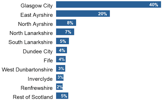
9.3 Just over 60% of all derelict and urban vacant land located within the 15% most deprived data zones is in either Glasgow City or East Ayrshire. Glasgow City has the highest proportion, with 40%, East Ayrshire contains 20%.
9.4 Glasgow City has had the largest amount of derelict and urban vacant land located within the 15% most deprived data zones for each of the last seven years. The area reported decreased by 157 hectares between 2013 and 2019 from 741 to 584 hectares.
9.5 Angus, Dumfries and Galloway, East Dunbartonshire, and East Lothian have data zones within Scotland’s 15% most deprived but did not have any derelict or urban vacant land situated within those areas in 2019.
9.6 Moray, Na h-Eileanan Siar, Orkney Islands and Shetland Islands have no data zones within Scotland’s 15% most deprived.
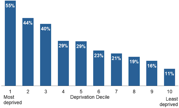
9.7 As data zones get progressively less deprived, the proportion of their population that lives within 500 metres of a derelict site becomes smaller (Chart 3).
9.8 55% of people living in the most deprived decile in Scotland are estimated to live within 500 metres of derelict land, compared to 11% of people in the least deprived decile.
9.9 Analysis used 2018 mid-year population estimates and SIMD 2016. Comparisons should not be made to years earlier than 2016 as results based on SIMD 2016 are not comparable with previous years based on earlier versions of the SIMD.
| Planning Authority6 | % of Local Authority Datazones within Scotland's 15% most deprived (SIMD 2016) | 2013 | 2014 | 2015 | 2016 | 2017 | 2018 | 2019 | |||||||
|---|---|---|---|---|---|---|---|---|---|---|---|---|---|---|---|
| Area of Vacant & Derelict Land (Hectares) | Sites | Area of Vacant & Derelict Land (Hectares) | Sites | Area of Vacant & Derelict Land (Hectares) | Sites | Area of Vacant & Derelict Land (Hectares) | Sites | Area of Vacant & Derelict Land (Hectares) | Sites | Area of Vacant & Derelict Land (Hectares) | Sites | Area of Vacant & Derelict Land (Hectares) | Sites | ||
| Aberdeen City | 3 | 5 | 3 | 5 | 3 | 4 | 3 | 2 | 2 | 2 | 3 | 2 | 3 | 2 | 3 |
| Aberdeenshire | 1 | 3 | 6 | 2 | 5 | 1 | 4 | 1 | 4 | 1 | 4 | 1 | 4 | 1 | 4 |
| Angus | 1 | - | - | - | - | - | - | - | - | - | - | - | - | - | - |
| Argyll and Bute | 8 | 2 | 7 | 2 | 7 | 3 | 7 | 2 | 6 | 2 | 5 | 2 | 5 | 2 | 5 |
| Clackmannanshire | 15 | 2 | 2 | 3 | 3 | 3 | 5 | 4 | 5 | 3 | 4 | 3 | 4 | 3 | 4 |
| Dumfries and Galloway | 6 | - | - | - | - | - | - | - | - | - | - | - | - | - | - |
| Dundee City | 29 | 71 | 89 | 74 | 91 | 77 | 95 | 70 | 85 | 60 | 80 | 61 | 79 | 60 | 79 |
| East Ayrshire | 22 | 72 | 27 | 310 | 29 | 309 | 27 | 309 | 27 | 308 | 27 | 306 | 20 | 299 | 18 |
| East Dunbartonshire | 2 | - | - | - | - | - | - | - | - | - | - | - | - | - | - |
| East Lothian | 2 | - | - | - | - | - | - | - | - | - | - | - | - | - | - |
| East Renfrewshire | 4 | 3 | 5 | 3 | 5 | 3 | 5 | 3 | 5 | 3 | 5 | 2 | 4 | 2 | 3 |
| City of Edinburgh | 10 | 18 | 8 | 18 | 8 | 18 | 8 | 16 | 8 | 16 | 8 | 11 | 5 | 9 | 6 |
| Falkirk | 11 | 17 | 7 | 16 | 6 | 16 | 6 | 14 | 6 | 18 | 6 | 18 | 7 | 17 | 5 |
| Fife | 14 | 58 | 33 | 60 | 34 | 59 | 34 | 51 | 31 | 56 | 33 | 55 | 31 | 53 | 31 |
| Glasgow City | 43 | 741 | 570 | 729 | 554 | 704 | 535 | 679 | 515 | 658 | 502 | 614 | 476 | 584 | 454 |
| Highland5 | 6 | 4 | 11 | 4 | 11 | 4 | 11 | 4 | 11 | 4 | 11 | 4 | 11 | 4 | 11 |
| Inverclyde | 36 | 55 | 76 | 54 | 78 | 46 | 65 | 43 | 62 | 40 | 55 | 44 | 57 | 41 | 53 |
| Midlothian | 6 | 3 | 2 | 4 | 3 | 4 | 3 | 4 | 2 | 3 | 1 | 3 | 1 | 3 | 1 |
| Moray | - | - | - | - | - | - | - | - | - | - | - | - | - | - | - |
| Na h-Eileanan Siar | - | - | - | - | - | - | - | - | - | - | - | - | - | - | - |
| North Ayrshire | 27 | 99 | 56 | 122 | 55 | 123 | 54 | 118 | 53 | 119 | 53 | 114 | 47 | 111 | 45 |
| North Lanarkshire | 23 | 85 | 102 | 92 | 109 | 89 | 109 | 86 | 105 | 104 | 106 | 98 | 107 | 101 | 110 |
| Orkney Islands | - | - | - | - | - | - | - | - | - | - | - | - | - | - | - |
| Perth and Kinross | 5 | - | - | - | - | - | - | * | 1 | * | 1 | * | 2 | * | 2 |
| Renfrewshire | 21 | 71 | 72 | 71 | 73 | 63 | 64 | 63 | 64 | 45 | 48 | 42 | 42 | 36 | 38 |
| Scottish Borders | 4 | 7 | 9 | 6 | 9 | 6 | 8 | 6 | 8 | 5 | 7 | 3 | 5 | 3 | 5 |
| Shetland Islands | - | - | - | - | - | - | - | - | - | - | - | - | - | - | - |
| South Ayrshire | 12 | 3 | 4 | 3 | 5 | 3 | 5 | 3 | 5 | 3 | 6 | 4 | 7 | 5 | 12 |
| South Lanarkshire | 14 | 80 | 58 | 82 | 64 | 83 | 65 | 73 | 61 | 73 | 59 | 68 | 53 | 71 | 56 |
| Stirling | 7 | 21 | 17 | 12 | 14 | 12 | 11 | 15 | 11 | 14 | 11 | 14 | 10 | 14 | 9 |
| West Dunbartonshire | 29 | 52 | 28 | 56 | 30 | 57 | 28 | 49 | 24 | 50 | 23 | 52 | 22 | 51 | 22 |
| West Lothian | 7 | 5 | 4 | 3 | 2 | 3 | 2 | 3 | 2 | 3 | 2 | * | 1 | * | 1 |
| Scotland | 15 | 1,476 | 1,196 | 1,730 | 1,198 | 1,688 | 1,154 | 1,617 | 1,103 | 1,589 | 1,060 | 1,523 | 1,003 | 1,475 | 977 |
1. Figures may not sum due to rounding.
2. 2013-2019 analysis uses the results of SIMD 2016. These figures should not be compared with those published in bulletins prior to 2016 which used an earlier version of the SIMD index.
3. See Annex D for details of council participation in different years.
4. During 2019, historical data for the years 2013-2018 were updated as a result of improved information. This included removing sites that should not have been included in previous years, adding sites that should have been included earlier and making any required changes to site size. Further information on this process is available in the Annex along with un-amended historical data for the survey years of 2000-2012.
5. Highland has not updated their survey since 2015 so their 2019 figures have been carried over from 2015.
6. Loch Lomond and the Trossachs National Park is not considered separately for this analysis.
7. Figures do not include urban vacant sites in settlements with a population of less than 2,000. These are reported separately in the Annex.
1. Analysis uses 2018 mid-year population estimates and the Scottish Index of Multiple Deprivation (SIMD) 2016.
2. Comparisons should not be made to years earlier than 2016 as results based on SIMD 2016 are not comparable with previous years that were based on earlier versions of SIMD.
Contact
Email: planstats@gov.scot