Proposal for a National Park in Southwest Scotland: report
Report submitted by NatureScot in its role as Reporter, setting out the findings of the public consultation and providing advice for the Scottish Government regarding the Galloway and Ayrshire National Park proposal.
Annex E: Assessing and selecting the area of the proposed National Park
1. In making its proposal for a Galloway National Park, Scottish Government asked NatureScot to investigate, consult and provide advice on possible options for the Park area. It also indicated that it could be smaller or larger than the area outlined in the bid.
2. This annex outlines the methodology used by NatureScot to develop its advice on the area that the proposed National Park could cover. It also provides a brief description of the boundary of the two options we consider in our advice. To undertake this work, we adapted the method we had previously developed for determining the areas of the existing two National Parks in Scotland. This was informed by commissioned research and discussion with key partners. At its core is a simple, structured approach based on desk-based review and field work.
3. The indicative area in the nomination by the Galloway National Park Association and Galloway & Southern Ayrshire Biosphere Reserve (see map 1) provided the starting point for consideration of the possible area of the proposed National Park, together with additional information provided by Scottish Government’s appraisal of the bid. Fieldwork and analysis described below together with input from Historic Environment Scotland helped develop options for the consultation. Following the consultation, further internal review was undertaken taking into account relevant responses to finalise NatureScot’s advice on the preferred area of the proposed National Park.
4. At this reporting stage, we are only considering broad areas for potential inclusion or exclusion, not a detailed boundary which would be identified and consulted on as a later part of the designation order process. While consulted on the principles that could inform the identification of a detailed boundary, further investigation would only be undertaken if the Scottish Government decided to proceed further towards designation of a National Park.
Approach
5. Experience in establishing the existing National Parks has shown the identification of a proposed Park area is a matter of judgement rather than a precise science. Community considerations are also important, which means that proposals can and should change as a result of consultation.
6. A structured approach to this task is essential. In particular, this needs to:
- differentiate between consideration of the broad geographic area (reporting phase) and the detailed consideration of its boundary (designation order phase),
- develop a set of criteria to help make, and explain, judgements about the area options being investigated and consulted on,
- consider the relationship between the planning and management of the proposed Park area with its surrounding area, and
- prepare a rational explanation to accompany the preferred option or options.
7. The approach we adopted is illustrated in figure 1 below. A full description was provided in the methodology report produced during the consultation phase.

Text for graphic below:
Conditions from Section 1(2) of National Park (Scotland) Act 2000
Step 1 - Table of indicators to assist interpretation of the conditions
Step 2 - Division of bid area and slightly beyond into sub-areas
Step 3 - Consideration of each sub-area against each condition using agreed indicators
Step 4 - Identification of one of more geographic options for the proposed National Park made up of different combination/s of sub-areas.
Step 5 – Consultation on these geographic options for the proposed National Park
Step 6 – Refinement of options in light of consultation responses as part of our advice to Scottish Ministers
8. The first step was to develop a set of indicators to help the detailed consideration of the three conditions for National Park status set out in Section 2(2) of the National Parks (Scotland) Act. Our starting point for this were the indicators previously developed for this purpose for the designation of the existing National Parks. Table 1 illustrates the finalised indicators together with notes on how they could be applied to southwest Scotland.
9. The second step was a desk-based review of the indicative area to divide it into a number of coherent sub-areas, as shown in Map 2. Divisions were based mostly on landscape character, using the national dataset, as this provided appropriate elements and a suitable scale for this stage of the work. To ensure the work was comprehensive, the sub-areas extended beyond the indicative area identified in the bid. Eighteen sub-areas were initially identified which is in line with the level of detail used for assessing the existing National Parks areas (20 sub-areas were identified for Loch Lomond & the Trossachs and 29 for the Cairngorms).
10. The third step was fieldwork, conducted over two weeks in late September and early October 2024, to assess each sub-area for its contribution to the three conditions of the Act. The fieldwork team of seven members of NatureScot staff was divided into four groups of at least two staff per fieldwork session, with a landscape architect involved throughout for consistency. The fieldwork also enabled a check on the validity of the draft sub-areas. As a result, 3 areas were amalgamated and 2 divided, reducing the number of sub-areas by one, to 17.
11. The fourth step was desk-based assessment to consider one or more possible geographic options for the National Park area made up of different combination/s of sub-areas using a five-fold ranking system for considering the case for inclusion of each sub-area from low to high as follows.
- Minimal
- Minor
- Partial
- Significant
- Extensive
12. The results of these exercise are shown in Table 2. As well as staff expertise, this exercise was informed by comments to a survey on the issues and opportunities within the proposed National Park area made on the online community information hub by members of the public during the pre-consultation phase of reporting work.
13. We identified three options for consultation made up of the following sub-areas:
| Option | Sub-areas |
|---|---|
| Hills and coasts | 7,8,9, 10,13 |
| Hills and extended coast | 1,5 7,8,9, 10,13, 14 and 15 |
| Hills, extended coast and countryside | 1-15 |
14. We considered that these three options presented the possible range of combinations of different sub-areas based on their contribution to the legislative conditions. They also made sense in broad geographic terms.
15. The fifth step was the consultation on these three geographic options for the proposed National Park. To inform responses, the consultation paper contained a short description of each option and our assessment on how it met the conditions of the Act – see Table 3.
16. While we received considerable comment on each of these of the three options and the extent to which they meet the legislative conditions for Park status, the methodology and appraisal which underpinned them were not challenged during the consultation.
17. An additional area, upper Glen Afton, was proposed by East Ayrshire Council during the consultation. This area was assessed as a sub-area in mid-March 2025 (with the findings included in Table 2 for comparison with the other sub-areas).
18. In the sixth step, we reviewed the assessment following comments received from the formal consultation and two options were investigated further. These two options are shown in Map 3 and described below.
- Option A - core hills and coast. This is a smaller than the smallest option we consulted on (option 1). It focuses on the Galloway Forest Park (GFP), Cairnsmore of Fleet National Nature Reserve (NNR) and the Fleet Valley National Scenic Area (NSA). These designations are mostly contained within sub-areas 7 and 8 of the area, both of which scored highly in terms of meeting the conditions of the Act.
- Option B -extensive hills, coast and countryside. This is the same as the largest option we consulted on (Option 3). It contains all the sub-areas which score highly in terms meeting all the conditions of the Act but also others which did not score so highly against all of them. The lowest ranking sub-areas - 16 and 17 - are excluded.
Map 4 provides a summary from all surveys of the degree of support and opposition by postcode with reference to these two options.
19. A brief description of an indicative boundary for both these areas is provided in Tables 4 and 5. Overall, the general considerations underpinning these involve a mix of river courses, river catchments, watersheds and minor roads. The precise boundaries of the Galloway Forest Park (GFP), Cairnsmore of Fleet National Nature Reserve (NNR) and the Fleet Valley National Scenic Area (NSA) would also need to be checked as these are established.
20. As with identifying the proposed area for designation, boundary setting is a matter of judgement, not a precise science. Experience from the current National Parks in Scotland and elsewhere in the UK, and results from the consultation suggest a flexible approach would be needed that reflects the features, and range of landscape types, which may be found at the margins of the area as well as the more detailed assessment of land management units, administrative boundaries and relevant natural systems and processes. Further consultation with land managers, community councils, local authorities and other public bodies will also be required.
NatureScot
May 2025
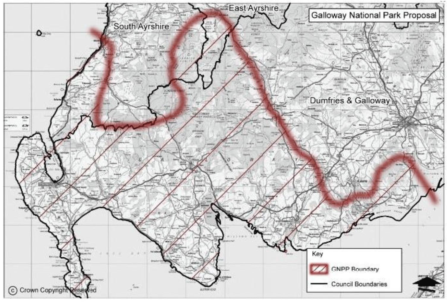
Table 1: Evaluation framework and indicators to assist with the identification of options for the area of the proposed National Park in Stage 1
Legislative Conditions: Outstanding National Importance
Components
Does the area contain nature conservation, landscape or cultural heritage interests of the highest national significance, extent and quality?
Indicators
Presence and extent of international, national and local designations for
1) biodiversity and geodiversity (European Sites; Sites of Special Scientific Interest, National and Local Nature Reserves)
2) landscape (National Scenic Areas, Wild Land Areas, and Local Landscape Designations)
3) historic environment (scheduled monuments, gardens and designed landscapes, historic battlefields, conservation areas)
Notes for proposal for a National Park in Southwest Scotland
Compared to their natural heritage equivalents, historic environment designations tend to be much smaller and/or point features. Discussion with Historic Environment Scotland helped to consider how these can be best be used in the assessment process alongside historic land-use assessment.
Components
Natural systems and processes – are they predominant in the sub-area?
Indicators
Extensive areas of semi-natural habitat, dynamic river systems and processes.
Notes for proposal for a National Park in Southwest Scotland
Much of the area is highly modified, though it will be important to look at river catchments and coastal systems in refining a preferred area and its boundary
Components
Do the special qualities of the area provide opportunities of national importance for enjoyment and understanding of the natural and cultural heritage?
Indicators
Range, scale and significance of outdoor recreation resources dependent on the special qualities of the area. Range, scale and significance of opportunities for the understanding of the natural and / or cultural heritage.
Notes for proposal for a National Park in Southwest Scotland
Key features include national paths and trails (e.g. Scotland’s Great Trails, National Cyle Network); recreational facilities (e.g. Forest Park, Dark Sky Park, 7Stanes, etc.) and visitor attractions (e.g. HES, NTS, RSPB Logan RBGE outstation etc).
Legislative Conditions: Distinctive character and coherent identity
Components
What is the contribution to the distinctive character of the area?
Indicators
Relative contribution of each subarea to the overall character of Galloway or southwest Scotland.
Notes for proposal for a National Park in Southwest Scotland
Judged from bid, information available from landscape character assessment and historic land-use assessment and fieldwork. Informed by contributions from Historic Environment Scotland.
Components
What is the contribution to the coherent identity of the area?
Indicators
Relative contribution of each subarea in terms of local traditions, sense of community identity and historical and artistic associations.
Notes for proposal for a National Park in Southwest Scotland
Judged from bid, information available from landscape character assessment and historic land-use assessment and fieldwork. Informed by contributions from Historic Environment Scotland.
Legislative Conditions: Special needs of the area
Components
Are the threats to the natural, cultural heritage and recreational qualities of the area, or opportunities for their enhancement, sufficient to merit national effort and enhanced resources?
Indicators
Loss or deterioration of natural and cultural heritage interests, or potential for their enhancement.
Nature of opportunities for enhancing the quality of the area.
Scale and significance of the need for more management of outdoor recreation, overcrowding, and traffic congestion.
Notes for proposal for a National Park in Southwest Scotland
Judged on information available and provided through the contributions received during pre-consultation phase.
Components
Does the management of the natural resources of the area require the more integrated and specialised approach of a National Park?
Indicators
Scale and significance of conflicts between different land uses, between land management activities and recreation use, and between different recreational uses.
Notes for proposal for a National Park in Southwest Scotland
Judged on information available and provided through the contributions received during pre-consultation phase.
Components
Are there likely to be specific social and economic benefits for the area of designation as a National Park?
Indicators
Dependence of the local economy on the sustainable use of its natural resources, and the natural and cultural heritage of the area.
Social and economic factors arising from the current pressures on the area.
Opportunities for marketing of products and services derived from the special qualities of the area.
Notes for proposal for a National Park in Southwest Scotland
Judged on information available and provided through the contributions received during pre-consultation phase.

Sub area |
Provisional name |
Outstanding national importance |
Distinctive character and coherent identity of the area |
Designation would meet special needs of the sub-area |
Assessment of contribution of sub-area to the legislative conditions |
|---|---|---|---|---|---|
|
|
|
5 – extensive 4 – significant 3 – partial 2 – minor 1 – minimal |
||
1 |
The Rhins |
Partial 3 |
Significant 4 |
Minor 2 |
3 |
2 |
Cairnryan to Ballantrae |
Partial 3 |
Partial 3 |
Minor 2 |
3 |
3 |
Ayrshire coast |
Partial 3 |
Partial 3 |
Minor 2 |
3 |
4 |
Wigtownshire and southern Ayrshire moors |
Partial 3 |
Minor 2 |
Minor 2 |
2 |
5 |
The Machars |
Partial 3 |
Significant 4 |
Minor 2 |
3 |
6 |
Ayrshire dales and foothills |
Minor 2 |
Partial 3 |
Partial 3 |
3 |
7 |
Galloway Hills |
Extensive 5 |
Extensive 5 |
Extensive 5 |
5 |
8 |
Glen Trool, Cree valley |
Significant 4 |
Significant 4 |
Extensive 5 |
4 |
9 |
Cairnsmore of Fleet, Creetown |
Extensive 5 |
Extensive 5 |
Extensive 5 |
5 |
10 |
Glenkens |
Partial 3 |
Significant 4 |
Extensive 5 |
4 |
11 |
Cairnsmore of Carsphairn |
Minor 2 |
Partial 3 |
Partial 3 |
3 |
12 |
Dee Lowlands |
Minor 2 |
Partial 3 |
Partial 3 |
3 |
13 |
East Solway Coast |
Significant 4 |
Extensive 5 |
Significant 4 |
4 |
14 |
Coastal Hills |
Partial 3 |
Extensive 5 |
Significant 4 |
4 |
15 |
Nith Estuary |
Extensive 5 |
Extensive 5 |
Significant 4 |
5 |
16 |
Water of Girvan |
Minor 2 |
Minor 2 |
Minor 2 |
2 |
17 |
East of Glenkens |
Minor 2 |
Partial 3 |
Minor 2 |
2 |
Post consultation |
|||||
- |
Upper Glen Afton |
Negligible 1 |
Minor 2 |
Minor 2 |
2 |
Table 3: Overview of the options for the proposed National Park area presented in the consultation paper in 5
Option 1: Hills and Coast
Size (ha)
155,915
Estimated Population
14,820
Main Settlements
Gatehouse of Fleet, Kirkcudbright, New Galloway, Newton Stewart
Percentage areas of each of main Nature and landscape designations
Nature designation
12% SSSI
6% SAC
0.9% SPA
1.2% Ramsar
1.2% NNR
0.16% LNR
Landscape designation
6% National Scenic Area
85% local landscape designations
Natural and cultural heritage importance
The area includes the Core area of the UNESCO Biosphere Reserve as well as one of two Wild Land Areas in South of Scotland. It also would incorporate most of the Galloway Forest Park and all of the Galloway Dark Sky Park and the Cairnsmore of Fleet National Nature Reserve.
The area comprises a distinctive mix of hills that form a regional landmark, and varied and highly scenic coastline of rocky promontories and estuarine flats. Parts of the area are long settled, with archaeological remains on the coast. Cultural heritage includes associations with artists, personified in Kirkcudbright as the painters’ town.
Distinctive character and coherent identity
In part because of the large-scale commercial forestry that dominates their lower slopes, the Galloway Hills are distinctive, wild and feel remote. They provide a regional landmark.
Lochs and rivers, and richly wooded river valleys are typical. The interplay of natural and cultural heritage, and the meeting of land and sea are key elements of the landscape of the area.
The infrastructure of early twentieth century hydroelectric power schemes is distinctive. In the Glen Kens it is the basis for water-based recreation.
Sometimes known as Scotland’s Riviera, the Solway coast is a long-established holiday destination. Settlements are often distinctive and traditional in character.
Meeting the special needs of the area
The area depends on both its primary production (forestry and agriculture) and the visitor economy. Accordingly, it relies on the health and quality of its natural and cultural heritage to sustain its socio-economic needs. There are extensive opportunities for nature recovery from source to sea, including restoration of peatland, native woodland, and coastal habitats.
There are land use issues relating to the balance between forestry, upland farming and recreation and their impacts on the natural and cultural heritage. Building more resilience to climate change in the commercial forestry sectors will be critical for its long-term success.
There is considerable scope for expanding recreational routes and opportunities, emphasising the relative wildness and challenging nature of the hills. There would be opportunities for both refreshing existing visitor facilities as well as developing new ones.
Initiatives that extended the visitor season and increased responsible tourism and public access would be of benefit.
Key questions to consider further
Should the communities of Dalmellington and Straiton be included?
Should Cairnsmore of Carsphairn be included?
Option 2 Hills and extended coast
Size
274,749
Estimated Population
42,434
Main Settlements
As option 1, plus Dalbeattie, Portpatrick, Stranraer, Whithorn and Wigtown
Percentage areas of each of main Nature and landscape designations
Nature designations
9% SSSI
5% SAC
1.6% SPA
1.7% Ramsar
1% NNR
0.34% LNR
Landscape designations
8% National Scenic Area
64% local landscape designations
Natural and cultural heritage importance
The area includes a much more extensive coastline of rocky headlands, low cliffs and sandy bays. The Mull of Galloway is the southernmost point of Scotland.
The cultural heritage includes the cradle of Scottish Christianity at Isle of Whithorn. Wigtown is Scotland’s book town, and WWII links include D-Day training locations. ‘Land of the Leal’ was set in the Rhins.
The start/end point of the Southern Upland Way is at Portpatrick on the west coast of the Rhins while new Kirkpatrick C2C cycle route starts/ends at Stranraer. There are stretches of coastal path which are the building blocks to the ambitious plans for a SW coastal long distance route. NCN 73 and 7 cross the area
Distinctive character and coherent identity
The inclusion of more of the Solway coast increases the marine character of the area. Extensive coastal flats are of an openness and horizontal scale unusual in Scotland, as is the incoming tide as fast as ‘a galloping horse’.
The coastal hills, particularly Criffel as well as the Mull of Galloway, are key landmarks.
The farmland, settlements and historic patterns of land use are distinctive. Drystone dykes are typical. The Machars peninsula in particular is said to be the epitome of Galloway culture.
It is an important food producing region and contains almost half the Scottish dairy herd in its lush pastures. There are hill sheep farms and beef cattle, of which the distinctive Galloway breed is synonymous with the region.
Meeting the special needs of the area
Many of the issues and opportunities described in Option 1 also apply here.
The inclusion of the larger coastline would provide more opportunities for restoring coastal habitats, managing the impacts of climate change and developing coastal and marine recreational opportunities, including completing the SW coastal path. The area would also be linked by train from Ayrshire, providing more opportunities for sustainable travel.
Depending on how far inland the extended area went, there could be more opportunities to support farmers to tackle climate change and increase biodiversity on their land in ways which benefited the resilience of their business. However, the extent of intensive [dairy] farming could lessen the difference that a National Park could make, given the smaller role of government support for these businesses.
Inclusion of more of the western communities such as Stranraer could help support economic recovery.
Key questions to consider further
How much of the countryside of the Machairs and Rhins should be included in addition to the coast?
Option 3 Hills, coast and countryside
Size
417,718
Estimated Population
61,402
Main Settlements
As options 1 and 2, plus Ballantrae, Barrhill, Castle Douglas and Girvan
Percentage areas of each of main Nature and landscape designations
Nature conservation
9% SSSI
4% SAC
3.2% SPA
1.2% Ramsar
0.6% NNR
0.22% LNR
Landscape designations
5% National Scenic Area
50% local landscape designations
Natural and cultural heritage importance
At Ballantrae there are rare remnants of once oceanic crust from ancient tectonic plate collisions.
Cultural heritage interests are extensive, with particular notable evidence of pre-historic hut circles to the east of the area.
The area includes both the Southern Upland Way and Ayrshire Coastal Long-Distance Routes, which together with NCN routes and many other paths and trails are part of the wide range of recreational opportunities of the region.
Distinctive character and coherent identity
In addition to the features of Options 1 and 2, the Carrick coast and countryside typically includes farmland backed by raised beaches. It is a well-settled landscape, with pastoral river valleys and policy woodland as well as upland farmland and moorland.
More of this area is characterised by extensive forestry. It also includes a number of large wind farms with related grid infrastructure.
Meeting the special needs of the area
Many of the issues and opportunities described in Options 1 and 2 also apply here.
The wider area is seen as critical to meeting renewable energy targets both through new wind farm capacity and improving related grid connections. A National Park could help plan for this positively with the industry and the community.
This larger area could also help realise a SW coast path to complement the other long-distance walking and cycling trails the area has to offer. It could also provide the potential to do more to record and promote understanding and enjoyment of the rich and distinctive cultural heritage of Galloway.
Inclusion of more of the north-western communities such as Barrhill and Ballantrae could help support economic recovery in this area. Girvan could benefit as gateway community even if not included.
Key questions to consider further
Should Girvan be included in the National Park?
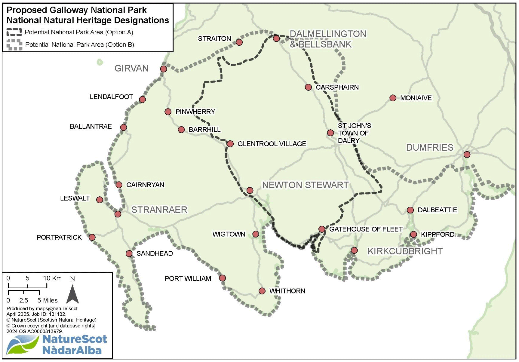
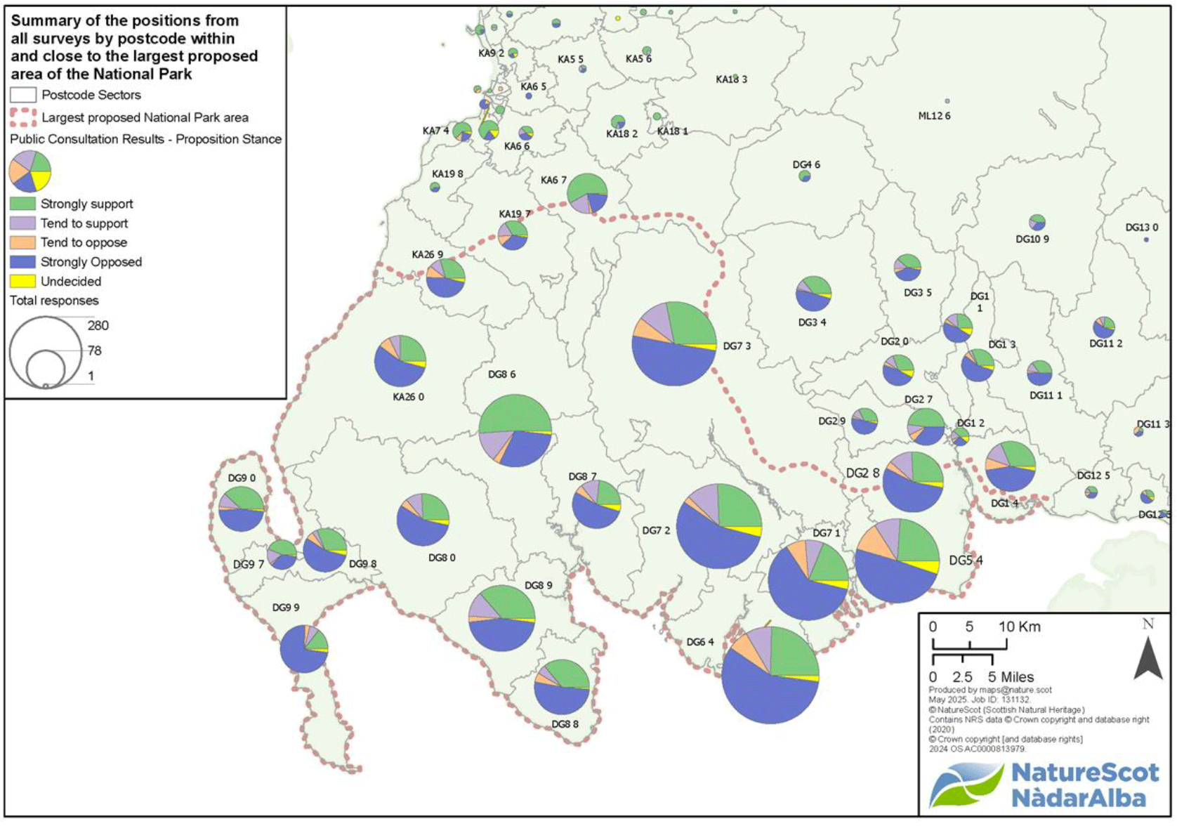
Table 5: Indicative boundary considerations for Option A Hills and Coast (presented clockwise from the northwest).
Barr to Bellsbank and Dalmellington
The GFP boundary may be complex in this area. It may be that a simpler National Park boundary could follow the River Stinchar from Barr, with that settlement being included. A line from Mid Hill to the west of Drumnellie Hill, perhaps along the Albany Burn, could achieve this. Alternatively, a line further east from around Loch Moan, and Polmaddie Hill, could join the River Stinchar further upstream at North Balloch and South Balloch.
The boundary would probably diverge from the River Stinchar near Tairlaw Plantation west of Loch Bradan, to encompass the upper reaches of the Water of Girvan and Straiton. East of Straiton, the Lambdoughty Burn and Red Burn could be followed to the River Don west of Dalmellington. There is a question whether to follow this line, or loop south to omit Dersalloch wind farm. The Red Burn, or the boundary of Craigengiallen Inventory Garden and Designed Landscape, could from the edge that would then include Dalmellington, and Bellsbank.
A boundary on the B741, perhaps quite close to the hills around Dalmellington, would then run southwards east of the A713.
Dalmellington to Carsphairn
The boundary could run southwards, east of the A713, taking a line along minor watercourses and a watershed, to omit large area of wind farms at South Kyle, Windy Standard etc. This would exclude at least half of sub-area 11, but we suggest incorporating the summit of Cairnsmore of Carsphairn, which is broadly similar to the Galloway Hills.
Carsphairn to south end of Loch Ken
The Glenkens settlements, including St John’s Town of Dalry, New Galloway, Balmaclllan, should be wholly included. This could be done by following minor watercourses and minor roads on the east side of valley.
The southern end of Glenkens would need careful consideration to avoid repeat entry/exit of National Park on any roads. We suggest excluding Castle Douglas, which nevertheless could serve as a gateway town. There is a range of historic features around the River Dee, such as Threave Castle that may influence the boundary and bring it further south; otherwise a line from Laurieston to the northwest may help to avoid an expanse of intensive agriculture.
South end of Loch Ken to Gatehouse of Fleet
A boundary to include parts of the Forest Park at Laurieston Forest and Glengap Forest, also staying west of the minor road from Gatehouse to Laurieston, could then line up with the Inventory Garden and Designed Landscape at Cally Palace and the adjacent Fleet Valley National Scenic Area.
Gatehouse of Fleet to Newton Stewart
The Cree could be used as a boundary; or include both banks and more of the estuary.
Newton Stewart should be within the Park. The boundary could follow one of the minor roads to the west of the town, perhaps the one joining the B7027, then following that towards Barrhill.
The boundary could cross the A714 to link with the Galloway Forest Park edge in the area, following that towards Barr
Table 6: Indicative boundary considerations for Option B – Hills, Coast and Countryside (presented clockwise from the northwest).
Girvan to Barr
Girvan, including the whole town; following valley of the Water of Girvan, on alignment to include both banks of the river, to Barr. Same boundaries as for Option A followed to south end of Loch Ken.
South end of Loch Ken to Mabie Forest
A line to head east, probably north of Crossmichael, and Old Bridge of Urr and Haugh of Urr (the north end of sub-area 12), to cross the A711 before running north to encompass Mabie Forest.
Mabie Forest to Caerlaverock
The boundary of the Nith Estuary National Scenic Area to be followed to the coast east of the Nith.
Caerlaverock to Girvan
Mean low water springs line
Contact
Email: Nationalparks@gov.scot