Developing a methodology to improve soil C stock estimates: report
Provides information on the minimum re-sampling densities required to evalaute carbon stocks on Scottish peatlands and includes an evaluation of the accuracy of the ECOSSE model to simulate measured changes in soil carbon.
4. Using ECOSSE to improve estimates of changes in soil carbon stock
4.1. Use NSIS data to improve the accuracy of ECOSSE and its ability to predict the response of Scotland's organic soils to external change
4.1.1 Introduction
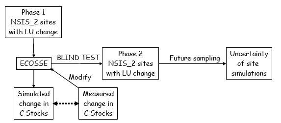
The ECOSSE model was run at all phase 1 and phase 2 National Soil Inventory of Scotland ( NSIS) sites (see section 2 for a detailed account of these data), using real weather data and the limited soil, land use and management data that would be available in the large scale national simulations (see figure 4.1.1). By comparing the simulated values with the measurements of soil C at the resampling date, these simulations were used to test the accuracy with which the model simulates changes in C content associated with the changes in climate as well as land use change over the ~30 year period between sampling dates. This assessment was done using data from the 62 phase 1 sites that have already been re-sampled. The model was modified and the improved simulations reassessed with respect to the NSIS_2 data. Subsequently, in a blind test, the model will be used to predict the changes in C contents expected in the phase 2 NSIS_2 sites (to be verified at a later date, when the samples have been taken).
Figure 4.1.1. Approach to evaluating performance of ECOSSE against NSIS_2 data
Good model performance is indicated statistically by simulations and easurements that are both coincident (indicating a close fit) and associated (indicating the trends in measurements are replicated). Where measurements are replicated, the coincidence between simulated and measured values is best expressed as the lack-of-fit statistic, and the significance of the coincidence determined using an F-test (Whitmore, 1991). However, replicates are not provided in the NSIS data, so the degree of coincidence was instead determined by calculating the total error as the root mean squared error and the bias in the error as the relative error (Loague & Green, 1991; Smith et al., 1996; 1997). The association between simulated and measured values was calculated as the correlation coefficient, and the significance of the correlation was determined using a t-test ( e.g. Chatfield, 1983). Sources of model error were also examined using graphical plots.
Because the detail in the input data was limited to that available at the national scale, these simulations provide an estimate of the uncertainty associated with simulations when the model is run using the national soils database to estimate changes in soil C stock for all of Scotland. This result is used in the description of the national scale simulations.
4.1.2. Input data
Soil
The Macaulay Institute provided the data from the NSIS sites that is required to run ECOSSE. The NSIS_2 sites follow a 20 km 2 grid, based on a sampling round carried out ~30 years ago ( NSIS_1). Data from both NSIS_1 and NSIS_2 resampling times for the 62 phase 1 sites were used in the evaluation of ECOSSE. Data from the NSIS_1 sampling time only were also made available at a further 120 phase 2 sites. These data were used to predict changes in C at the NSIS_2 resampling time and could be used in future work in a blind test of ECOSSE when the NSIS_2 resampling is complete.
Land use change
The original land use at the NSIS_1 sites and any changes in land use occurring before the NSIS_2 resampling were used as inputs to the simulations. Note that no exact dates of land use change are available, and it was assumed that land use change occurred half way through the simulation period. This introduces uncertainty in the model inputs, which will be discussed later.
Weather
The weather data were downloaded as a grid of 5 km 2 from the climate monitoring service of the MetOffice UK: http://www.metoffice.gov.uk/research/hadleycentre/obsdata/ukcip/index.html. Long term average monthly data are based on the period of 1961-1990. Actual monthly data are only available up to 2005. This restricts the evaluation period to 2 years before the NSIS_2 resampling time, which was spring 2007.
4.1.3. Data preparation
Data from 62 NSIS (1+2) sites were reformatted as inputs to ECOSSE and used to run ECOSSE simulations at each site. The C contents measured in the NSIS_1 sampling were used to initialize the model run using long-term average weather data and assuming the soil organic C is in a steady state. The simulation was then run forward to 2005 using actual monthly data for the simulation period. NSIS_2 measurements of soil C were used to evaluate the model performance.
For litter layers, such as "L", "F" or " LF", C data were mostly missing. Since the data were missing, the model simulations in these layers could not be evaluated. Therefore, they were omitted from the simulation and horizon depths of layers below were adjusted so the first layer in the simulation would always start with 0 cm. Note that the national simulations (section 4.2) included all layers in the soil profile as given in the national soils database and did not omit litter layers. Layers of rock were defined as the bottom of a profile and water impermeable and iron pan layers were defined as fully water impermeable. Some layers included two entries in the database as the horizon showed different attributes across its depth. The average of the two attributes was used in the simulations.
The total C was calculated for each depth using bulk density and % C. The amount of C was corrected for the percentage of stones in the soil. In some instances, NSIS_2 did not have the same percentage of stones as recorded in NSIS_1. This is likely to be due to spatial variability at the site coupled to errors in locating the original sampling point plus error in locating the resample (reduced by use of GPS). To allow a fair comparison between C contents at the two sampling times, the NSIS_2 C contents were adjusted to assume the percentage of stones found in NSIS_1. Horizon depths were corrected similarly.
In order to process the large number of data, R scripts were developed to assist in input and output generation and create graphical and tabular output. The script can be used with a small modification to the standalone version of ECOSSE.
Note that although the model was run at all 62 sites, due to the size of the inherent experimental error, the results were only used for model evaluation at the 9 sites where land use change had occurred. This is explained further below.
4.1.4. Results
Figure 4.1.2 shows the simulated soil C plotted against the measured data at the time of NSIS_1 and NSIS_2 samplings. The 1:1 line is given in the plots, and represents perfect agreement between the simulations and the measurements. The close agreement between the points and the 1:1 line in the NSIS_1 plot indicates that the model is correctly initialised using the NSIS_1 data. The spread of points around the 1:1 line increases in the NSIS_2 plot, indicating some errors in the simulation of changes in soil C with time. However, over all sites, the correlation between the simulated and the measured values is high and statistically significant (r 2 = 0.94; P < 0.001).
As indicated in table 4.1.1, the correlation between simulations and measurements is statistically significant for all land uses. Overall, the total error between the simulated and measured values of C at the NSIS_2 resampling time is 20% of the average measurement. The accuracy of the simulations decreases in the order natural/semi-natural > forestry > arable > grassland. As will be discussed below, errors between simulations and measurements occur in some simulations. These are associated with inaccuracies in the measurement inputs, as well as being due to the errors in the model. However, because these errors are all part of the uncertainties encountered in the simulations at large scale, it could be argued that these values of uncertainty should be used to represent the potential uncertainty in the simulations at national scale.
Table 4.1.1. Evaluation of degree of association and coincidence between values simulated by ECOSSE using the limited data input available at national scale and measurements at the 62 first phase NSIS sites
Association |
Lack of Coincidence |
||
|---|---|---|---|
Land Use |
r 2 |
P-value |
RMSE (%) |
Arable |
0.91 |
<0.001 |
21 |
Grassland |
0.93 |
<0.001 |
39 |
Forestry |
0.97 |
<0.001 |
19 |
Natural/semi-natural |
0.94 |
<0.001 |
15 |
Over all land uses |
0.94 |
<0.001 |
20 |
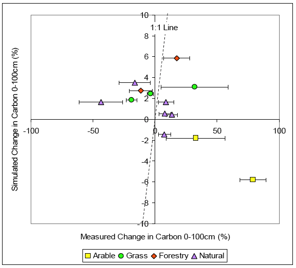
Since it is the change in C content that is of interest in these simulations, the simulated change in C content was compared to the measured C change. This is expressed as a percentage change to normalise the impact of C change at high and low C content sites (Smith et al., 1996). Unfortunately, the errors in the measurements with this type of resampling exercise can be extremely high. This is due to inherent spatial variability especially at unmanaged sites as well as the time period of unrecorded management between the first and second sampling dates and the difficulty in relocating sampling sites. As illustrated in figure 4.1.3, at sites where no land use change has occurred, the errors in the measurements are larger than the variation in soil C, and so no meaningful statistical analysis is possible. The sites where land use change has occurred are shown in figure 4.1.4. It is only these sites, where land use change has occurred, that are included in the following analysis.
Figure 4.1.2. Simulated vs measured values of soil organic carbon in the soil profile 0-100cm at the time of the NSIS1 and NSIS2 samplings
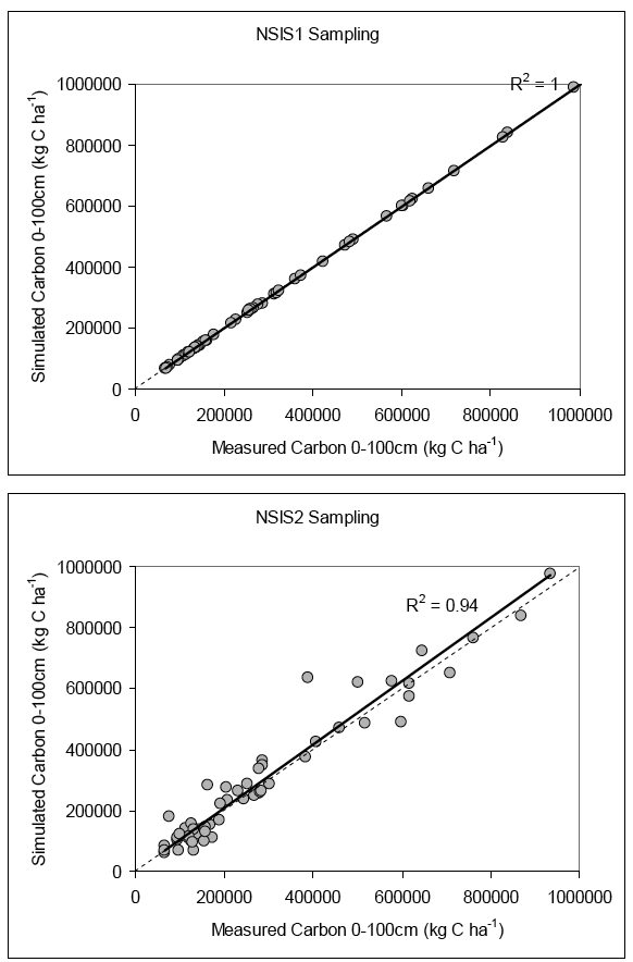
Figure 4.1.3. ECOSSE simulated values against measured values of change in carbon content for the NSIS sites where no land use change has occurred. The error bars show the 95% confidence interval for the measured values.
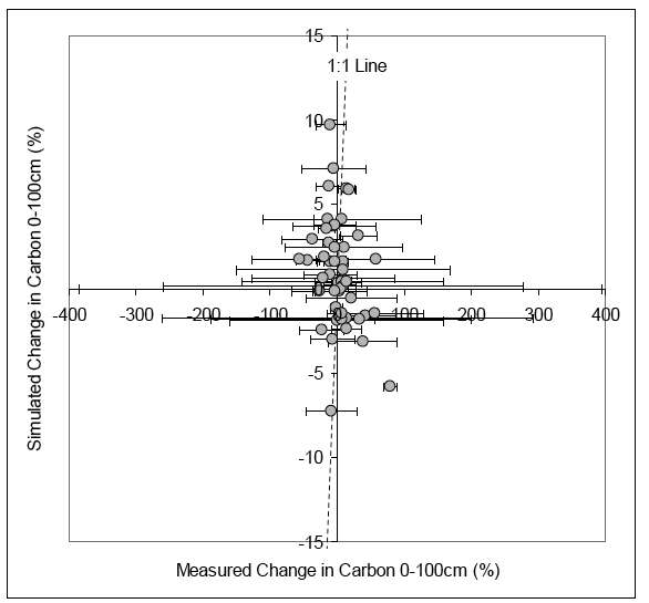
Table 4.1.2. Estimated errors in measurement at the 9 NSIS sites where land use change occurs
Land use change |
Site |
Soil association / series / type |
95% confidence interval for % change in soil C |
|---|---|---|---|
Arable to grassland |
NJ200600 |
Alluvial / Traquair |
68 |
NN600000 |
Alluvial / Lochside |
35 |
|
NO000200 |
Balrownie / Balrownie / Brown forest soil with gleying |
69 |
|
Grassland to arable |
NJ400600 |
Tynet / Aulthash |
19 |
NJ800200 |
Tarves / Thistlyhill / Brown forest soil with gleying |
38 |
|
NK000600 |
North Mormond / North Mormond |
13 |
|
NO800800 |
Auchenblae / Auchenblae |
31 |
|
Natural to forestry |
NN600600 |
Arkaig / Kildonan / Peaty podzol |
21 |
NO000600 |
Strichen / Strichen / Humus iron podzol and iron podzol |
180 |
|
Average |
53 |
||
Average excluding sites with 95% CI over 35% |
24 |
||
Figure 4.1.4. ECOSSE simulated values against measured values of change in carbon content for the 9 NSIS sites where land use change has occurred. The error bars show the 95% confidence interval for the measured values.
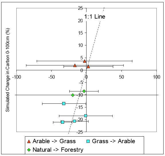
Simulation of change in C content is a more stringent test of the model than the simulation of total C content. Over all sites where land use change has occurred, the correlation between the simulated and the measured values is given by r 2 = 0.25. This is not significant, suggesting the simulations and measurements are not highly associated. However, the picture changes when the experimental error is taken into account. The 95% confidence intervals of the measured values are shown on the plot, and are also given for each land use change site in table 4.1.2. For four sites, the 95% confidence intervals of the measurements are very high; greater than 35%. If these sites are excluded from the analysis, the correlation coefficient increases to r 2 = 0.80. Although the r 2 value is high, this is still not significant, due to the low number of measurements now included in the comparison (only 5). However, the simulated values are all within the measured 95% confidence interval of the 1:1 line between simulations and measurements, suggesting the association between simulations and measurements is within experimental error.
The average deviation between the simulations and the measurements is only 11% if all points are included and 7% if the measurements with high experimental error are excluded. This is less than the average measured deviation at the 95% confidence interval (53% for all points and 24% when measurements with high experimental errors are excluded). Therefore, the coincidence between the simulations and the measurements is also well within experimental error; the model cannot be improved further against this data (Smith et al., 1997). The bias in the simulations is very low; -4% for all measurements. Therefore, only a small systematic underestimate (-4%) is expected in the national simulations.
The simulations at the sites where land use change have occurred are all within the experimental error, but at 25% of the sites without land use change (22% of all sites), the simulated values show a greater deviation from the measurement than the recorded experimental error (see figure 4.1.5).
Figure 4.1.5. ECOSSE simulated values against measured values of change in carbon content for the NSIS sites where no land use change has occurred and the simulations deviate from the measurements by more than the 95% confidence interval in the measured values. The error bars show the 95% confidence interval for the measured values.
The sites where the error between simulations and measurements exceeds the recorded experimental error include all land use types, so no systematic error due to including a particular land use type has been identified. At two arable sites, ECOSSE simulates a small decline in soil C (-2% and -6%), whereas a large increase is measured (+33% and +79% respectively). It is unlikely that such a large increase in soil C would occur without some change in land use or management. This illustrates one type of error that occurs due, not to the failure of the model, but rather due to the shortage of information available to run the model (as would be the case at the national scale). These errors may have been attributable to the use of improved crop varieties, changes in cropping practice (such as straw incorporation), or an interim period of grassland resulting in a build up of soil C before the land is converted back to arable. Similarly, at two grassland and two semi-natural, a relatively large decline in soil C is measured (grass = -19% and -4%; semi-natural = -43% and -16%), whereas the model simulates a small increase (grass = +2% and +3%; semi-natural = +2% and +4%). This again could be due to an interim period of land use change, resulting in the reduction in soil C, before the land is converted back to grassland or semi-natural use. At one forestry site, a relatively large decline in soil C is observed (-12%), whereas an increase is simulated (+3%). This may be attributable to disease, drainage of a highly organic site or incorrect assumptions about the age class of the forestry. At the remaining sites, the simulated values have the same sign as the measurements, and are usually only slightly outside the reported experimental error.
4.1.5 Conclusions
Simulations have been run at all 62 sites included in the first phase of the NSIS_2 analysis. The simulated values show a high degree of association with the measurements in both total C and change in C content of the soil. The uncertainty in the simulations is 20% of the average C content over all land use types, uncertainty increasing in the order natural/semi-natural < forestry < arable < grassland. Over all sites where land use change occurred, the average deviation between the simulated and the measured values of percentage change in soil C was less than the experimental error (11% simulation error, 53% measurement error). This was still the case if measurements with very high experimental error were excluded (7% simulation error, 24% measurement error). The correlation between simulations and measurements was not significant (r 2 = 0.25 for all sites; r 2 = 0.80 if sites with high errors were excluded). However, simulated values were within the 95% confidence interval of the 1:1 line between simulated and measured values, so the simulated values were again within experimental error with respect to correlation. Only a small bias in the simulations compared to the measured values was observed, suggesting that a small underestimate of the change in soil C should be expected in the national simulation (-4%).
A large proportion of the uncertainty is associated with uncertainty in the input data: these include uncertainties in
1. timing of land use change,
2. actual management of arable land, grassland and forestry, and
3. unrecorded land use change before the start of and during the simulation.
These factors are also likely to be unknown at national scale, and so the erroneous results due to uncertainty in the input data are included in the estimate of uncertainty in the simulations. There is potential to greatly decrease the uncertainty associated with unrecorded land use change in the national simulations by developing algorithms to estimate the likely rate of C accumulation or loss at the start of the simulation. These algorithms could be developed from long term experiments on the basis of climate, land use and soil type and would be used to set up a standard soil organic matter pool structure for each soil / land use type at the start of the simulation, which then determines the subsequent rate of soil organic matter turnover.
Note that a major limitation of these estimates of uncertainty is the small number of sites included in the first phase of the NSIS re-sampling where land use change had occurred. Improved estimates of uncertainty at the national scale could be achieved by including more land use change sites in the next phase of resampling. Sub-sampling all land use units within >20 x 1km 2 grid squares across the country and repeating the simulations of changes in C content done here would greatly improve estimates of uncertainty. This would require changes to the long term soil sampling strategies. The costs /benefits of such a change in land use monitoring should be considered further.
4.2. Use national scale simulations of ECOSSE to address policy questions
4.2.1. Introduction
The ECOSSE model was used together with soils, land use and weather data to simulate changes in soil C content across the whole of Scotland. Soils and climate data were available on a 1km 2 grid across Scotland, whereas land use and land use change data were only available on a 20km 2 grid. The land use and land use change data were interpolated, allowing results to be reported on a 1km 2 grid.
Simulations were of three types:
1. Historical simulations to determine changes in soil C content each decade since 1950, apportioning the losses to different soil types and changes in land use. These address the policy questions: "What C emissions can be attributed to Scottish soils?", "Which land use changes are responsible for the losses in soil C?" and "On which soil types do most losses in soil C occur?".
2. Future simulations using projected changes in land use and climate. These address the policy questions: "What are the changes in soil C due to projected land use change over the next decade?" and "What are the changes in soil C due to projected climate change during this century?".
3. Calculations of the potential of different mitigation options to reduce soil C losses. These address the policy question: "Which mitigation options are most likely to reduce losses of soil C?".
The revised national estimates of changes in soil C stocks not only determine the total change in soil C, but also apportion the observed change to specific changes in land use, management or climate. This is of crucial importance if we are to implement effective mitigation measures to protect vulnerable soil C sinks (Reay et al., 2007). Bellamy et al. (2005) suggest a link to climate change to explain the observed mean loss of soil organic C of 0.6% yr -1, between 1978 and 2003 in England and Wales. The attribution to climate change has been questioned (Smith et al., 2007b). The findings also contradict evidence that the UK and Europe as a whole is a net CO 2 sink (Janssens et al., 2003) and data from another long term study of soil organic C in British woodlands (Kirkby et al., 2005) suggesting a small increase in soil organic matter over 30 years (0.094% increase y -1). Other repeated sampling studies in Europe have shown contrasting results, with some showing loss of soil organic C ( e.g. for Flemish cropland soils; Sleutel et al., 2003), attributed to changing manure application practices, and others showing no loss of soil organic C (in Danish croplands; Heidmann et al., 2002 and in Austrian soils; Dersch & Boehm, 1997). Our results provide modelling evidence that will allow the observed C changes in Scottish soils to be attributed to different drivers, and will provide an important contribution to this debate.
4.2.2. Adaptation of ECOSSE to use new data
Changes completed in ECOSSE to allow it to run with the new data include the following:
- Initialisation of C pools and plant input
- Optimisation of plant input to achieve zero C change under steady state conditions
- Analytical solution of initialisation of C content and plant input under equilibrium conditions (Hillier solver)
- Initialisation of C pools for soils that are not at equilibrium, but accumulating C (note, standard soil pool structures derived from long term experiments for each land use / soil type would be needed to simulate soils that are already loosing C).
- Weighting of soil variables according to proportions coming from each SOM layer.
- Changes to description of soil water
- Description of impermeable soil layer
- Changes to use wetness class in model runs
- Changes to allow water content below wilting point
- Improvement of simulation of methane production and oxidation
- Adjusted pH effect on methane oxidation
- Improved diffusion routine
- Changes to input/output
- Changes to format to include soil pH and soil wetness class
- Changes to allow a variable number of layers in the soil profile
- Hole filling of missing data
- Changes to allow simulation of future projections in land use
- Changes to use UKCIP weather data scenarios for future simulations
4.2.3. Historical Simulations
Soil Data
The national soil spatial dataset
The soil attribute dataset is based on the component soils that are delineated on the national scale 1:250 000 scale soil map. This soil map covers the whole of Scotland and comprises 580 soil map units. The vector dataset has been converted to raster format into 100m grid cells. The mapping took place between 1978 and 1982 and incorporated existing 1:63 360 scale mapping to give complete coverage of Scotland with a common framework. The nature of this reconnaissance scale mapping means that soil/landscape units were identified and mapped rather than individual soil types as is common with greater resolution mapping.
The soils are mapped by a procedure known as 'free survey' in which the soil surveyor selects the soil profile sites by using his field knowledge of soil forming processes in relation to the factors he observes in the landscape. As the mapping was done at a reconnaissance scale, landform units that recur throughout Scotland were used as the basis for delineating soil/landscape units (Soil Survey Staff, 1984). These soil/landscape units were also found to contain a similar set of soils although the type of parent material varied. A combination of parent material (soil association) and landform was used to construct a numeric soil key which contained 580 soil units (plus some subdivision of the organic soil units). This approach means that individual map units are likely to contain more than one soil type. The soils were mapped at the major soil subgroup taxonomic unit (mssg) rather than at the soil series level, which is used in more detailed mapping.
Subsequent work identified the component soil series of each of these 580 map units (that is, a specific mssg with a specific drainage category developed on similar parent materials) and the approximate proportion of each soil series within the soil map unit was determined by expert judgment (and partial validation). Because of the broad scale approach of this mapping, only 530 soil series were delineated within this spatial dataset. This set of soil series and their proportions is the basis of the national scale spatial dataset.
The 1:250 000 scale soil map has been digitised and the resulting vector dataset has been converted to raster format to a resolution of 100m grid cells. The proportion of each soil map unit in each of these 100m cells was determined within a GIS, multiplied by the proportion of individual soil series within each map unit and summed to derive the proportion of each soil series within each grid cell. The results were then ranked by areal extent and the top 5 most extensive soils and their proportions selected to represent the component soils of that grid cell. This resulted in a spatial dataset of approximately 80 000 geo-referenced grid cells with the top 5 most extensive soil series and their proportions.
Soils data requirement of the GIS version of ECOSSE
The data requirements of the model are summarised below.
Soil distribution (1 km 2 Grid)
- 20km 2 gridID
- 1km 2 gridID
- Easting
- Northing
- Area (m 2)
- Series 1-5
- % of cell under series (note, total of all 5 series may be less than 100%)
- Soil depth for series (cm)
- Soil wetness class for series
Soil characteristics
For each horizon and for each of arable, grassland, forestry and semi-natural soils:
- Top depth (cm)
- Bottom depth (cm)
- % C
- C (kg x 10 6 km -2)
- % Clay
- % Silt
- % Sand
- Bulk density (g cm -3)
- pH
An existing attribute dataset which is linked to the soil spatial dataset via the soil series was used to derive the soil data required for the model. SSKIB (Scottish Soils Knowledge and Information Base; Lilly et al., 2004) holds statistical summary data for a set of typical soil horizons for each soil series delineated on the 1:250 000 soil map of Scotland.
Derivation of data for cultivated and semi-natural soils
Using expert knowledge, typical horizon sequences and depths were derived for each of the 530 soil series in the national spatial dataset. These were based on the central concepts of each series and took account of the information contained within the Scottish soil morphological database. A distinction was made between cultivated and uncultivated versions of the same soil series as both the soil chemistry and horizon sequences differ. Once the typical horizon sequence had been derived, summary statistics were derived from the Scottish soil analytical database. Only soil horizons that matched those selected as being typical for that series were used in the derivation of the summary statistics. Certain criteria were applied; for example, where a horizon nomenclature matched the typical horizon but the organic C content was outside normal limits, the horizon would be eliminated from the statistical analyses. Similarly, data for horizons sampled at depth below 1m were ignored. Where horizons could be designated with more than one horizon, for example, Bsh or Bhs, these were treated as being synonymous.
SSKIB contains, amongst other attributes and contextual information, summary data on the number of horizons used in the calculations, the geometric mean, the mean, the median and standard deviation, minimum and maximum values for a wide range of physical and chemical attributes derived from the Scottish soil analytical database. An example of the range of these soil attributes is shown in Table 4.2.1. Where no values were determined as there were no data for the specific series, data from an analogous series were used. Where a specific attribute had no data, this was generally due to very low values which were below the detection limit. In these cases, the detection limit was applied as the attribute value. In some cases there were limited soil profiles available and so the standard deviation of some or all soil properties could not be determined.
Table 4.2.1. The physical and chemical soil attributes contained within SSKIB
HOR_ SYMB |
Soil horizon notation |
|---|---|
SERCODE |
Soil Survey of Scotland 5 figure numeric code applied to each Soil Series |
LOI |
Loss on Ignition (percentage) |
CA |
Calcium content (meq/100g) |
MG |
Magnesium content (meq/100g) |
NA |
Sodium content (meq/100g) |
K |
Potassium content (meq/100g) |
H |
Hydrogen and Aluminium content: Exchangeable acidity (meq/100g) |
SUM |
Sum of the Mean values of all exchangeable cations (Ca, Mg, Na, K and H) |
SATN |
Percentage saturation of Mean values of base cations (Ca, Mg, Na and K) as a proportion of the Sum of exchangeable cations. |
PHW |
pH in water |
H(ueq/L) |
H ion equivalent of soil pH |
C |
Elemental Carbon content (percentage) |
N |
Elemental Nitrogen content (percentage) |
DER_ OM |
Organic Matter content derived from Mean value of C*1.724 |
TOTP |
Total Phosphate (mg P2O5/100g) |
CLAY |
Percentage clay (<2microns) |
SILT |
Percentage silt (2- 50/60 microns) |
SAND |
Percentage sand (50/60- 2000 microns) calculated from (100-(clay+silt)) |
The dataset supplied for use in ECOSSE modelling contains a subset of SSKIB. Mean values for a range of attributes were derived from SSKIB along with contextual information. These are shown in Table 4.2.2.
Table 4.2.2. SSKIB contextual and attribute data derived for the ECOSSE project
SERIES |
Soil Survey of Scotland Soil Series name |
|---|---|
SERCODE |
Soil Survey of Scotland 5 figure numeric code applied to each Soil Series |
LANDUSE |
Whether the soil profile is from arable, grassland, forestry or semi-natural land cover types |
HOR_ SYMB |
Soil horizon notation |
UPPER_DEPTH |
Upper depth of the soil horizon |
LOWER_DEPTH |
Lower depth of the soil horizon |
MEAN_ PHW |
Mean value of pH in water |
MEAN_C |
Mean value of elemental Carbon content (percentage |
MEAN_CLAY |
Mean value of the percentage clay (<2microns) |
MEAN_SILT |
Mean value of the percentage silt (2- 50/60 microns) |
MEAN_SAND |
Mean value of the percentage sand (50/60- 2000 microns) |
SD_ PHW |
Standard deviation value of pH in water |
SD_C |
Standard deviation value of elemental Carbon content (percentage) |
SD_CLAY |
Standard deviation value of the percentage clay (<2microns) |
SD_SILT |
Standard deviation value of percentage silt (2- 50/60 microns) |
SD_SAND |
Standard deviation value of percentage sand (50/60- 2000 microns) |
Db |
Dry bulk density of <2mm fraction predicted by pedotransfer functions based on clay, silt and organic carbon contents |
STONE_CONTENT |
Estimate of the percentage of stones in each horizon |
Translation of data into arable, grassland, forestry and natural / semi-natural categories
As previously described, SSKIB summary statistics were calculated for cultivated and semi-natural soils. However, data were required for arable, grassland, forestry and semi-natural land uses. Soil profiles under afforested land often acquire an LF layer which is either thin or absent from many semi-natural soils. This has implications for the estimated C content of these soils. Similarly, there are generally differences in organic C contents and pH of soils under arable compared with those under grassland. In order to derive estimates of C and pH for the 4 land uses, correction factors had to be derived as the C contents and pH values of soils in SSKIB were averages of both arable and grassland soils (cultivated) and of both semi-natural and afforested soils (semi-natural).
Values for both pH and C content of cultivated topsoils from the Scottish Soils Analytical Database were classified according to whether the land use was recorded as arable or grassland (soils with rotational grassland, which is part of an arable rotation, were treated separately). The mean C content and pH were then determined for arable (n=2055 and 2009) soils and for grassland soils (n=152 and 142) where C contents were less than or equal to 15% (mineral and humic soils only). The mean C content of all cultivated soils was 3.8% while the mean for arable soils was 3.6% and 5% for grasslands. Therefore, 0.2% was subtracted from all SSKIB topsoil C mean values to derive a value for arable soils while 1.2% was added to derive a value for C contents of grassland soils. For pH, arable topsoils were increased by 0.04 pH units while grassland topsoils were decreased by 0.46.
There were only slight differences in organic C contents of surface organic layers under forestry compared with semi-natural soils with some horizons having greater organic C contents in afforested soils compared with semi-natural and vice versa so no adjustment was made. Instead, the average thickness of an ' LF' horizon (which also included F, FH and L horizons) under afforested soils was determined along with average C content and its standard deviation. This horizon was added to all semi-natural soil profiles to derive an afforested soil profile. The bulk density of the LF horizon was taken from a number of measured LF horizons rather than being derived by pedotransfer functions.
Stone Content
Stone content is included so that estimates of volume of C can be adjusted for stony soil horizons. Each data field is labelled according to the horizon number (up to 9) and by land use e.g. A1 is the first arable horizon, SN1 is the first semi-natural horizon.
Soil Wetness class
The soil wetness class was determined for each of the 5 most extensive soil series in each 1 km grid cell. Soil wetness class was determined by combining soil and climate data (Lilly et al., 2003). Soil Wetness Class is an attribute that has been used in UK national land evaluation systems for many years (Bibby et al., 1982; MAFF 1988) and allows all soils in the UK to be assigned to one of six classes based on the depth to, and duration of, saturated conditions as indicated by the presence of a water table (Table 4.2.3). By definition, it represents long term, typical conditions (Hodgson, 1997). Soil Wetness Class can be predicted using pedotransfer rules (Jarvis et al., 1984; Lilly and Matthews, 1994) based on the attributes of depth to a slowly permeable layer (Ks < 10 cm day -1) and depth to gleying. In essence, Soil Wetness Class uses basic soil information to refine the climate attribute 'Field Capacity Days'. This attribute is derived from modelled predictions of evaporation from standardised conditions; a deep, loamy soil under a short grass crop with no inhibition to drainage and a large store of water. Differences in soil drainage and soil texture from these standardised conditions will alter the number of days that a soil is saturated.
Table 4.2.3. Definition of Soil Wetness Classes
Wetness Class |
Duration of Waterlogging |
|---|---|
I |
The soil profile is not waterlogged within 70 cm depth for more than 30 days in most years. |
II |
The soil profile is waterlogged within 70 cm depth for 30-90 days in most years. |
III |
The soil profile is waterlogged within 70 cm depth for 90-180 days in most years. |
IV |
The soil profile is waterlogged within 70 cm depth for more than 180 days, but not waterlogged within 40 cm for more than 180 days in most years. |
V |
The soil profile is waterlogged within 40 cm depth for 180-335 days, and usually waterlogged within 70 cm for more than 335 days in most years. |
VI |
The soil profile is waterlogged within 40 cm depth for more than 335 days in most years. |
1 The number of days specified is not necessarily a continuous period.
2In most years is defined as more than 10 out of 20 years.
After Jarvis et al. (1984)
Figure 4.2.1 gives an indication as to how soil wetness can be temporally distributed. This assumes that the greatest potential soil moisture deficit occurs at the end of July and the dry period is evenly distributed around this date.
Figure 4.2.1. Periods of the year when soil is deemed wet for each Soil Wetness Class
Land use data
The CEH land use and land use change database
The database includes
- 20km 2 grid cells covering Great Britain (cell ID, northing, Easting)
- 1km 2 cells covering Great Britain (cell ID, northing, Easting)
- Historical decadal land use change (average annual in kha yr -1 allocated in each 20 km 2 cell) for 1950-59, 1960-69, 1970-79, 1980-1989, 1990-1999.
- Predicted decadal land use change (average annual in kha yr -1 allocated in each 20 km 2 cell) for 2000-2009, 2010-2019.
Land use and land use change data requirement of the GIS version of ECOSSE
The land use and land use change data requirements are as follows:
- 20km 2 gridID
- Easting
- Northing
- In each decade, land use change from…
- Arable
- Grassland
- Forestry
- Natural / Seminatural
…to
- Arable
- Grassland
- Forestry
- Natural / Seminatural
Derivation of land use data required by the model
The land use change matrices were provided by CEH (A.Thompson, pers. comm.) in a format that can directly be read by ECOSSE and does not need any modifications
Preparation of land use data for use in ECOSSE
Land use change files are the same as used in the ECOSSE project (Smith et al., 2007b).
Weather data
The retrospective run of the model uses monthly long-term average data. Data were downloaded as a grid of 5 km 2 from the climate monitoring service of the MetOffice UK: http://www.metoffice.gov.uk/research/hadleycentre/obsdata/ukcip/index.html. Monthly long term average data are based on the period of 1961-1990.
The weather data requirements of ECOSSE are as follows:
- 20km 2 gridID
- Easting
- Northing
- Rainfall (mm month -1) Jan to Dec
- Air Temperature (mm month -1) Jan to Dec
- Longitude
- Latitude
Results and discussion of historical simulations
Simulated values of changes in soil C were output both on a 1km 2 and a 20km 2 grid. The higher resolution results provide a more accurate estimate of the distribution of results. The lower resolution output allows direct comparison to the CEH estimates of CO 2 emissions.
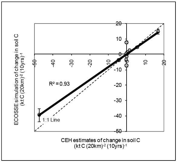
A comparison of the average changes in soil C content across Scotland as estimated by ECOSSE and by CEH (D.Mobbs & A.Thompson, CEH Edinburgh, summary given in Smith et al., 2007b) is shown for 1990-1999 in figure 4.2.2 and for 2000-2009 in figure 4.2.3. The results show the changes in soil C content calculated using a simulation started in 1950. Changes in soil C stocks due to land use change occurring between 1950 and the end of the time slice all contribute to the changes in soil C stocks estimated in the given time slice. The effects on soil C of any land use change that occurred before 1950 will be omitted from the results, but the effect of land use change on soil C diminishes with time, so this is not anticipated to introduce a large error in the estimates.
The results from the two decades are similar. The correlation between the ECOSSE and CEH estimates is given by r 2 = 0.97 and r 2 = 0.93 for 1990-1999 and 2000-2009 respectively, which is highly significant (P < 0.001). A t-test also indicates that the mean values estimated by the two approaches are not significantly different in either decade. This provides confidence in the results are these two very different approaches are able to provide broadly similar results. The results do, however, differ in the detail.
Figure 4.2.2. Comparison of changes in soil carbon content from 1990-1999 due to a range of different land use changes as estimated by ECOSSE and by CEH. Values are averaged across Scotland. Error bars indicate the uncertainty in the simulations calculated from the simulation of NSIS sites as the average deviation of the simulations from measurements (root mean squared deviation = 11%).
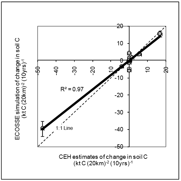
Figure 4.2.3. Comparison of changes in soil carbon content from 2000-2009 due to a range of different land use changes as estimated by ECOSSE and by CEH. Values are averaged across Scotland. Error bars indicate the uncertainty in the simulations calculated from the simulation of NSIS sites as the average deviation of the simulations from measurements (root mean squared deviation = 11%).
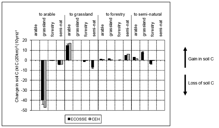
The simulated changes in soil C attributed to the different land use changes between 2000 and 2009 are shown in figure 4.2.4. Values are averaged across Scotland. Similar results were obtained between 1990 and 1999. Most land use changes produce changes in soil C estimated by the two methods that are of a similar magnitude and sign. The estimates of changes in soil C made by ECOSSE on land use change semi-natural to grassland show a larger loss of soil C than estimated by the CEH method. Similarly, ECOSSE estimates a larger gain in soil C on land use change grassland to semi-natural. Correspondingly, a larger loss of soil C is estimated by ECOSSE than by the CEH method for the land use change forestry to semi-natural and a smaller gain in soil C for the land use change semi-natural to forestry. These differences occur due to processes that are included in ECOSSE but not in the CEH approach associated with soil disturbance and reduced plant inputs when vegetation is immature. Carbon losses due to soil disturbance and an initial reduction in the plant input result in a loss of soil C or a smaller gain than estimated by CEH for land use changes between semi-natural land and grassland or forestry.
Figure 4.2.4. Comparison of simulated changes in soil carbon content from 2000-2009 divided according to land use change as estimated by ECOSSE and by CEH. Values are averaged across Scotland. Error bars indicate the uncertainty in the simulations calculated from the simulation of NSIS sites as the average deviation of the simulations from measurements (root mean squared deviation = 11%).
The CEH approach uses the observed C contents of Scottish soils under the different land uses (Milne et al., 2004). The CEH approach estimates the change in soil C, XT2-T1 (t C), between land use change times T2 and T1 from the area of land undergoing the given land use change, AT (ha), the equilibrium soil C content under the initial land use, C0 (t C ha -1), the equilibrium soil C content under the final land use, Cf (t C ha -1), and a time constant for the change, k.

where T0 is the start of the simulation, and T is the time of any land use change.
(adapted from Milne et al., 2004).
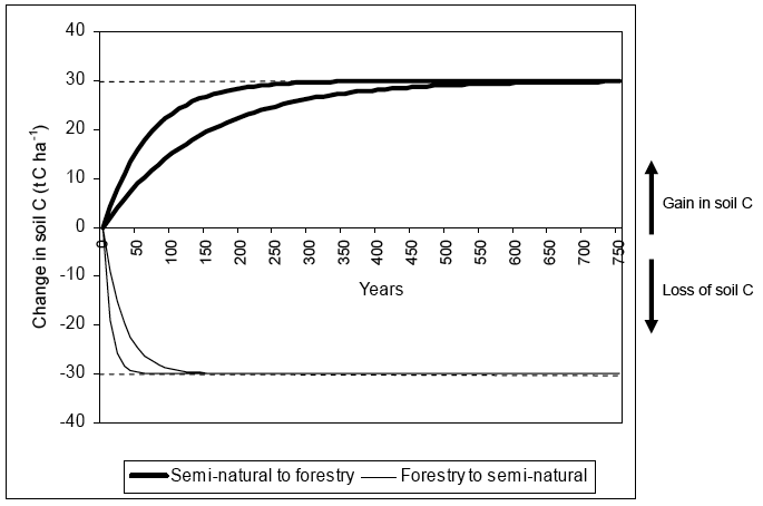
This equation describes the changes in soil C using exponentially declining rates of change, the difference between the equilibrium soil C contents under the final and initial land uses, ( Cf - C0) (t C ha -1), determining the asymptote of the curve, and the time constant, k, determining the rate of loss or gain, as shown for the example of land use change between semi-natural and forestry in figure 4.2.5. These terms are cumulated across all land use changes occurring since time T0 to give the total change in soil C in the given year or decade. Note that the rate of loss is more rapid than the rate of gain, so describing the time required to stabilise soil C during the process of C sequestration. The values of Cf and C0 are determined for each type of land use from measurements of the equilibrium C contents of Scottish soils divided into the soil categories aquic, high activity clay, low activity clay, sandy and organic. Because a higher equilibrium C content is usually observed under forestry than semi-natural, this inevitably results in an increase in soil C content with the land use change semi-natural to forestry even in the first years following land use change.
Figure 4.2.5. CEH estimates of change in soil carbon on land use change semi-natural to forestry and forestry to semi-natural in Scotland. Note a gain in soil carbon occurs more slowly than a loss of soil carbon. The two lines represent the minimum and maximum rate of change assumed.
ECOSSE also uses the equilibrium soil C content under different land uses to determine the change in soil C associated with each land use change. It does this by using the equilibrium soil C content to determine the amount of plant input and the distribution of soil pools under the different land uses at steady state. The plant input is assumed to be reduced from the rate calculated in the equilibrium run during the initial period of semi-natural or forestry growth up to the time when the plants mature, but then increases to its full rate after this time. On disturbance of the soil due to land use change, a proportion of the slowly decomposing soil humus pool is passed back to the more rapidly turning over soil organic matter pools of biomass, resistant plant material and decomposable plant material. This simulates the reduction of physical protection of soil organic matter that would occur when long term uncultivated soil is disturbed by management operations. The proportion passed back from the humus pool for long term uncultivated land uses (grassland, forestry and semi-natural) is currently set to 0.5, following an analysis by West and Post (2002) of global data on the effects of tillage on losses of C from the soil. An initial loss of soil C can occur even where the steady state soil C content used to initialise the model is higher under the new than the original land use if the period since the land use change occurred is not sufficient for the soil and vegetation to have reached steady state. If for example the area of land use change to forestry was to significantly increase over the next decades, as planned in the Climate Change (Scotland) Bill 2009 [as passed], an initial decline in soil C could be observed, especially if this was to come from semi-natural land which has a steady state soil C content close to that of forestry.
The observation of a decline in simulated soil C immediately after afforestation of grassland and semi-natural land is supported by experimental evidence both globally and from the UK. In a meta-analysis of 74 publications including data from 16 different countries on the impact of land use change on soil C stock, Guo and Gifford (2002) found a reduction in soil C when pasture was converted to plantation (-10%). This is consistent with the decline (of 50%) in total soil C observed by Zerva et al. (2005) during the first rotation following afforestation of a peaty gley soil in the NE of England. The extent of the decline in soil C content is highly dependent on soil type, the management of the land, and the nature of the disturbance. An ECOSSE simulation of changes in soil C stocks on afforestation of a semi-natural NSIS site, NN600600 (see section 4.1), is shown in figure 4.2.6. Two simulations are shown (see table 4.2.4); a simulation assuming disturbance of the site on afforestation (proportion passed from humus pool = 0.5 as used above), and a simulation assuming the minimal disturbance that might be associated with optimum minimum intervention management and longer rotations (proportion passed from humus pool = 0).
Table 4.2.4. Summary of forestry management and ECOSSE characteristics associated with different levels of disturbance on afforestation
Definition of forestry management |
Definition in ECOSSE |
|
|---|---|---|
Disturbance on afforestation |
Standard practices of land preparation for forestry |
Proportion of C passed from humus pool to more rapidly decomposing pools ( DPM, RPM, BIOMASS) = 0.5 |
Minimal disturbance on afforestation |
Optimum minimum intervention management and longer rotations |
Proportion of C passed from humus pool to more rapidly decomposing pools ( DPM, RPM, BIOMASS) = 0 |
The initial reduction in soil C simulated by ECOSSE is 15% in the simulation assuming disturbance, and only 3% in the minimal disturbance simulation. The C losses associated with the simulation assuming disturbance are well within the reported range, whereas losses from the minimal disturbance simulation are too low, suggesting that some effect of soil disturbance should be assumed. If the proportion of material passed from the humus pool were 0.35, the reduction in soil C stocks would be 10% as obtained by Guo and Gifford (2002) in their review (see "Fitted" on figure 4.2.6). Guo and Gifford (2002) attributed the decline in soil C content on land use change grassland to forestry to
- the shallower distribution of soil C in forestry as compared to grassland resulting in less soil C in the profile as a whole despite a higher surface soil C stock under trees,
- the persistent tree root system resulting in the annual turnover of organic matter from dying tree roots being less than from grass roots, and
- woody plants depositing a larger fraction of organic matter on the surface than grasses resulting in less formation of stabilised soil organic matter.
Our results would suggest that soil disturbance could also be a factor. Note the Guo & Gifford results suggested a permanent decline in soil C of 10%, whereas this simulation would give a temporary dip. The recovery of the soil C levels is dependent on management of the forestry following afforestation.
Guo and Gifford (2002) found that tree type and precipitation had a significant impact on soil C losses; planting broadleaf trees on pasture had no significant impact on the soil C stocks, but planting conifer trees (mostly Pinus radiata) significantly reduced soil C stocks by 12%. However, by contrast, a review of forest CO 2 fluxes from temperate, boreal and Mediterranean regions (Law et al., 2002) found no significant difference in stand-scale CO 2 fluxes between deciduous broadleaf forests and evergreen coniferous forests. In low rainfall areas (<1200mm year -1), Guo and Gifford (2002) observed the land use change had little impact on the soil C stocks, but in higher rainfall areas with precipitation over 1500 mm year -1, soil C stocks were significantly reduced (-23%). With annual precipitation of 1300 to 1400 mm year -1, Scotland as a whole is intermediate between Guo and Gifford's definition of a low and high rainfall area. Within Scotland, annual rainfall ranges from 600 to 4000mm, so the impact of the land use change will also depend on the location.
Many authors report a relationship between stand age and change in soil C content. In a review of UK BioSoil sites (a large EU soil and biodiversity survey in forestry), Morison et al. (2008) reported that growing conifer forests, especially in peaty soils and in their first rotation, can decrease soil C stocks by as much as 30%. Measurements of soil C stocks following afforestation of unplanted natural grassland with Sitka spruce ( Picea sitchensis) on a peaty gley soil at Harwood Forest in N.E. England showed significant changes in both the total amount and the distribution of soil C (Zerva and Mencuccini, 2005a; Zerva et al., 2005). The total C stocks declined significantly during the first 40 year rotation, with the lowest soil C content at the time of clear felling, but then increased to levels approaching the unplanted grassland by the end of the second rotation (80 years) due to the incorporation of brash during clear felling. The vertical distribution of soil C changed with a higher proportion of the C stored in the litter layer O L and A layers after afforestation. Zerva and Mencuccini (2005a) attributed this to the input of persistant woody material to the litter layer under trees and the mixing of the soil during clear felling at the end of the first rotation. The ECOSSE simulation of the NSIS site, NN600600, undergoing land use change semi-natural to forestry was extended to 160 years using long term average weather data (figure 4.2.6). No attempt was made to explicitly simulate the processes of clear felling and brash incorporation, although these are implicitly included in the values of total soil C content under forestry used to initialise the model. If the site is assumed to be disturbed on afforestation, the time to net sequestration of soil C is 140 years. If minimal disturbance of the site is assumed, the time until net sequestration of soil C can be as low as 15 years. With disturbance fitted to the 10% soil C losses observed by Guo and Gifford (2002), the time to net sequestration of soil C is between 70 and 80 years. This suggest that at Harwood Forest, the level of disturbance simulated should be intermediate between the simulation assuming the site is disturbed and the simulation assuming minimal disturbance, at around the level of the fitted simulation (proportion of humus released to other pools = 0.35). If sufficient national information were available on practices of felling and brash incorporation, it would be useful to explicitly simulate these processes, so that the national implications of changing practices could be ascertained.
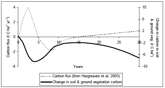
Within each rotation, changes in the direction of soil C fluxes are observed. In an analysis of CO 2 flux measurements from Scottish peatlands that were drained, ploughed and afforested with conifer plantation dominated by Sitka spruce ( Picea sitchensis), Hargreaves et al. (2003) observed an initial loss of C from peat and ground vegetation up to 5 years after afforestation, followed by a period up to 10 years when the peat plus ground vegetation started to sequester C. After 15 years, canopy closure resulted in less ground vegetation and the peat became an increasing source of C (~1 t C ha -1 year -1). This is equal to in a cumulative change in the C held in soil and ground vegetation as shown in figure 4.2.7. Note the similarity in the shape of the curve calculated by ECOSSE (figure 4.2.6) and the changes in C held in soil and ground vegetation calculated from the data of Hargreaves et al. (2003), both curves showing an initial sharp decline, followed by an increase that levels off at around 15 years after afforestation. In a second rotation stand, Ball et al. (2007) measured lower annual loss of soil C from the 20 year old stand than from the 30 year old stand and clear-felled sites on the peaty-gley soil at Harwood Forest, and attributed the differences to changes in soil temperature. Soil conditions and soil type have a significant impact on the extent of losses. By comparison to the Scottish peatland studied by Hargreaves et al. (2003), Zerva & Mencuccini (2005b) calculated a higher rate of C loss from the peaty gley at Harwood forest (3.5 t C ha -1 year -1), whereas the losses calculated from a review of available data by Reynolds (2007) suggest that losses from an organo-mineral soil are much lower at 0.5 t C ha -1 year -1 (although Reynolds notes the results are inconclusive). The ECOSSE simulation of NN600600 estimates no long term decline in soil C as this is an undrained site.
The study of Hargreaves et al. (2003) only considered stand age up to 26 years, so the accumulation of C noted by Zerva and Mencuccini (2005a) in the second rotation was not observed, and the C losses from the soil and ground vegetation were extrapolated to the future at a rate of 1 to 2 t C ha -1 year -1.The longer term losses described are largely attributable to the drainage of the peat, but the short term losses were attributed to the reduced inputs associated with the land use change. Despite this conclusion of long term loss from the soil and ground vegetation, the results presented by Hargreaves et al. (2003) also showed that the C fluxes from peat, ground vegetation and trees when all taken together become negative after only 10 years, and the system would remain a net sink for 90 to 190 years. This result is consistent with simulations of long term rates of C sequestration in the timber of British woodlands ranging from 1.0 to 5.4 t C ha -1 yr -1 (Morison et al, 2008), which would exceed the C losses from the soil. While this illustrates the need to consider the changes in C stocks in vegetation as well as in the soil when designing policies to reduce total C emissions, this project focuses on C losses from Scottish soils; changes in greenhouse gas emissions associated with vegetation are beyond the scope of the project. Timber production can also bring additional emission reductions associated with substitution of high energy embedded materials and fossil fuels, which should also be included in any comprehensive analysis of greenhouse gas emissions from Scottish forests.
Although the results are highly variable, it is clear that the afforestation of semi-natural land leads to some initial reduction in soil C, due to reduced inputs of plant C and the disturbance of the soil on planting, but that this may change to a net increase in soil C after the forestry has become established. The different conclusions published from different studies reflect the influence on the extent of soil C loss of soil type, previous land use, nature of land preparation, management of the stand and the species included in the study. The disturbance of the soil and its effect on the extent of C loss is perhaps the largest source of uncertainty. Schmidt et al. (1996) and Mallik and Hu (1997) found significant loss of soil C associated with mechanical site preparation, whereas Paul et al. (2002) found no significant effect of disturbance level. The Forest Research draft Carbon Review (Morison et al., 2008) concluded that soils under forestry stands with minimum intervention management and longer rotations can sequester significant amounts of C, whereas shorter rotations with frequent disturbance may result in net loss of soil C. The information used to determine the ECOSSE parameters that describe the impact of soil disturbance on conversion to forestry is largely based on shorter term rotations. If a larger proportion of forestry in Scottish soils uses minimum intervention management and longer rotations, the simulated increase in soil C on conversion to forestry may have been under-estimated, and the recovery time simulated by the model may be too long. These uncertainties illustrate the urgent need for further experimentation for evaluation and development of models to simulate physical protection and disturbance of the soil on land use change semi-natural to forestry.
Figure 4.2.6. Simulation of total soil carbon (0-95cm) at NSIS site NN600600 with land use change semi-natural to forestry on a peaty podzol (association = Arkaig, series = Kildonan). Extrapolation of results over the 160 years using long term average weather data. Simulation of the time before net accumulation of soil C occurs following afforestation. Assuming minimal disturbance, time to net soil C sequestration = 15 years. Assuming the soil is disturbed on afforestation, time to net soil C sequestration = 140 years.
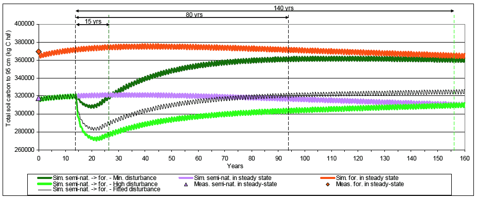
Figure 4.2.7. Change in carbon held in soil and ground vegetation calculated from data from Hargreaves et al., 2003.
A comparison of the distribution of simulated results across Scotland is shown for 2000-2009 in figure 4.2.8. Similar results were observed in 1990-1999. Notice a similar pattern in the emissions estimated by the two approaches, following the distribution of changes in land use across the country, but higher variability in the emissions estimated by ECOSSE, reflecting the impact of the more detailed soil information used. Some grid squares are empty in the 1km 2 map. This is due to a land use change being recorded in the 20km 2 scale land use change data, but no soil characteristics being defined under the soil types found in that particular 1km 2 cell. This is due to the mismatch of the 20km 2 and 1km 2 data and is currently recorded as an error so the results are not included in the output. In future simulations, an alternative method for dealing in this mismatch in the data will be sought. Note that because of the way the simulations are run, this introduces no error in the overall results for Scotland or the 20 km 2 maps.
The highest losses in soil C are simulated in the land use change grassland to arable (see figure 4.2.4). A comparison of the distribution of simulated results across Scotland for the land use change grassland to arable is shown for 2000-2009 in figure 4.2.9. Again, a similar overall distribution is observed, but with notable differences associated with the soil type. Note, in particular, that ECOSSE simulates an area of lower emissions in the borders than was estimated by CEH, due to the land use change grassland to arable not occurring in this region. If the soil characteristics are not defined for a particular land use, this land use change will be excluded from the ECOSSE simulation. This means that unrealistic changes in land use are filtered out, providing an additional check for realism in the simulations.
The highest simulated sequestration of C occurs due to land use change arable to grassland (see figure 4.2.4). A comparison of the distribution of results across Scotland for the land use change arable to grassland is shown for 2000-2009 in figure 4.2.10. The overall distribution estimated by the two approaches is similar, but again with greater variability in the ECOSSE results, reflecting the soil characteristics.
Policy Relevant Questions
What total carbon emissions can be attributed to Scottish soils?
The total changes in soil C across Scotland as estimated by CEH and ECOSSE are given in table 4.2.5. While the estimates in changes in soil C stocks are very similar in 1990-1999, the ECOSSE simulations estimate soil C losses that are a little lower than the CEH estimates in 2000-2009.
Table 4.2.5. Simulated changes in soil carbon across Scotland as estimated by CEH and by ECOSSE
CEH estimate of annual changes in soil C for Scotland (kt year -1) |
ECOSSE estimate of annual changes in soil C for Scotland (kt year -1) |
Difference ( CEH- ECOSSE) (kt year -1) |
|
|---|---|---|---|
1990-1999 |
-913 |
-822 |
-9 |
2000-2009 |
-878 |
-810 |
-68 |
Which land use changes are responsible for the emissions?
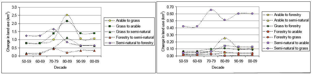
The ECOSSE simulated annual changes in soil C for Scotland between 1950 and 2009 for the different land use changes are shown in figure 4.2.11. The land use changes that result in these changes in soil C are shown in figure 4.2.12. The changes in soil C stocks are the soil C changes occurring during given decade only, but are the effect of land use changes occurring from the 1950s up to the given decade, so will account for the long-term as well as the short-term impacts of land use change. The simulated total change in C stocks becomes more negative ( i.e. increased emissions) up to the end of the 1970s when the change in C stocks increases sharply ( i.e. decreased emissions), although remaining negative (net C emissions). The increase occurs due to a levelling off of the losses associated with the land use change grassland to arable and forestry to semi-natural, and increased sequestration associated with conversion of arable land to grassland. Conversion of forestry to semi-natural results in net emissions up to the 1970s, because the plant communities have not had time to reach maturity. After this time, the greater maturity of the earlier converted land results in decrease in emissions. Increasing the area of land use change from arable to grass has the highest potential to sequester soil C, and decreasing the area of grass to arable has the highest potential to reduce losses of soil C. Note that changes in the 1950s and 1960s may have been underestimated due to omission of land use changes that occurred before the start of the simulation, but the trends from the 1970s to 2000s show a clear effect.
Figure 4.2.8. Simulated change in soil carbon stocks due to all land use changes occurring in Scotland 2000-2009 (a) CEH estimates (b) ECOSSE simulations (20km2 resolution) (c) ECOSSE simulations (1km2 resolution)
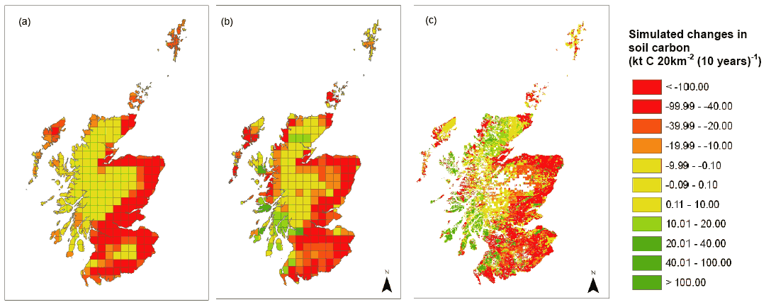
Figure 4.2.9. Simulated change in soil carbon stocks due to land use change grassland to arable occurring in Scotland 2000-2009 (a) CEH estimates (b) ECOSSE simulations (20km2 resolution) (c) ECOSSE simulations (1km2 resolution)
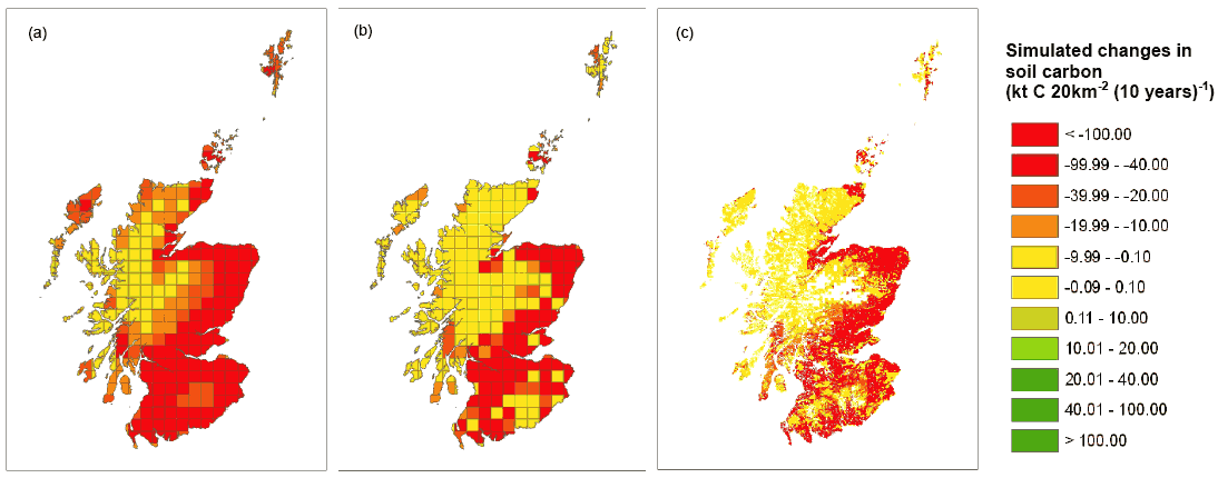
Figure 4.2.10. Simulated change in soil carbon stocks due to all land use change arable to grassland occurring in Scotland 2000-2009 (a) CEH estimates (b) ECOSSE simulations (20km2 resolution) (c) ECOSSE simulations (1km2 resolution)
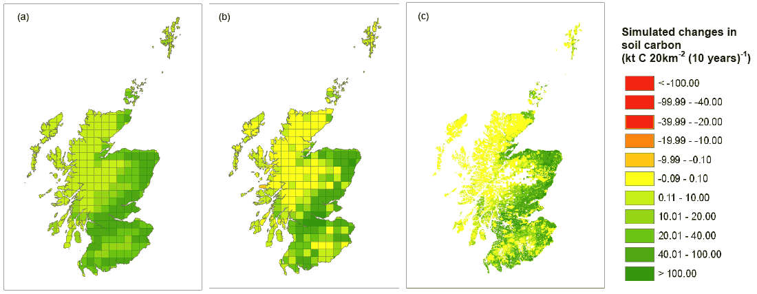
Figure 4.2.11. Simulated total changes in soil carbon stocks across Scotland from 1950-2009 for different land use changes as simulated by ECOSSE. Note the change scale in the two graphs.
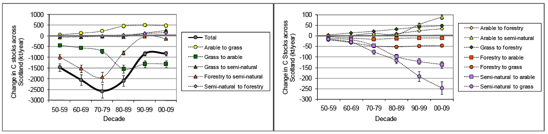
Figure 4.2.12. Simulated total changes in land use across Scotland from 1950-2009 as specified by CEH land cover map. Note the change in scale of the two graphs.
On which soil types do most emissions occur?
The ECOSSE simulated changes in soil C since 1950 across Scotland for organic and mineral soils are shown in figure 4.2.13. Organic soils are defined here as soils with a C content of over 6% (Smith et al., 2007b). On average, losses from organic soils represent 64% of the total losses. Across Scotland, the simulated change in soil C from organic soils between 1950 and 2009 is -62512 kt, compared to -35351 kt from mineral soils.
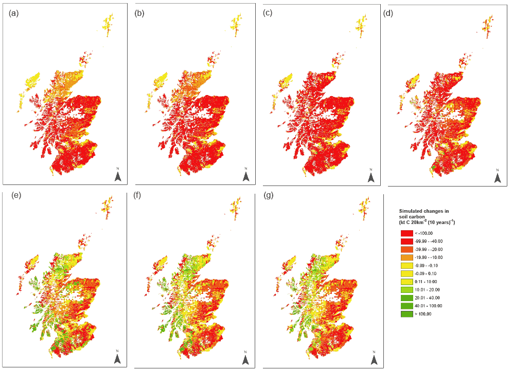
The distribution in the simulated changes in soil C stocks in organic soils is shown from 1950-2010 in figure 4.2.14. Note the high losses of C from organic soils up to 1980, when the losses decline to a lower level as plant communities from the earlier land use changes mature.
Figure 4.2.13. Simulated total changes in carbon stocks across Scotland from 1950-2009 for different soil types as simulated by ECOSSE assuming soil disturbance on afforestation.
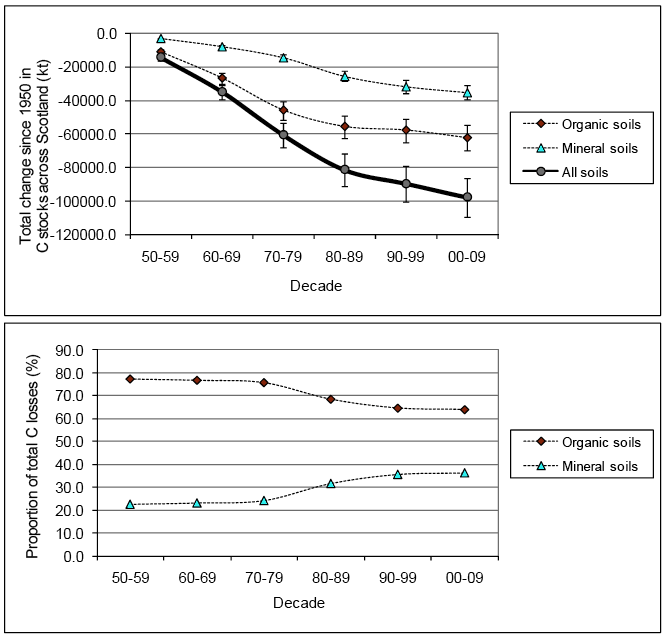
Figure 4.2.14. ECOSSE simulations of changes in soil C stocks on organic soils across Scotland due to all land use changes occurring between 1950 and 2010. Simulations assume soil disturbance on afforestation (a) 1950s; (b) 1960s; (c) 1970s; (d) 1980s; (e) 1990s; (f). 2000s; (g) 2010s
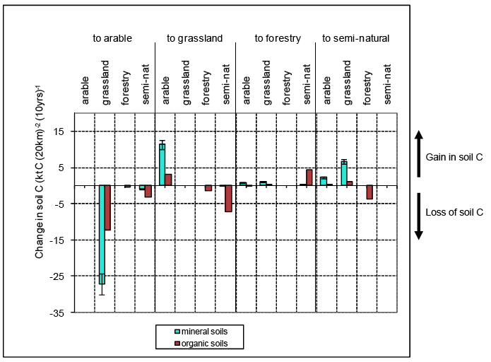
The distribution of losses between organic and mineral soils associated with the different land use changes that have occurred since 1950 as simulated by ECOSSE are shown in figure 4.2.15. The results represent the emissions that occur between 2000 and 2009, but show the impact of land use changes occurring between 1950 and 2009. The largest losses in soil C are associated with the conversion of mineral soil from grassland to arable, while the largest gains in soil C are associated with the conversion of mineral soil from arable to grassland. Other large losses in soil C are observed due to conversion of organic soils from grassland to arable, and from semi-natural to grassland. Whereas the changes in soil C in mineral soils are largely compensatory, the changes in organic soils are not, resulting in an average loss of soil C from organic soils of 19 kt (20 km) -2 (10 years) -1, compared to an average loss from mineral soils of only 5.5 kt (20 km) -2 (10 years) -1.This emphasizes the importance of organic soils in any national estimates of greenhouse gas emissions. These results suggest that mitigation options to reduce losses of soil C might recommend different policies for land use change on mineral and organic soils.
Figure 4.2.15. Comparison of simulated changes in soil carbon content from 2000-2009 divided according to land use change on organic and mineral soils as estimated by ECOSSE. Values are averaged across Scotland. Error bars indicate the uncertainty in the simulations calculated from the simulation of NSIS sites as the average deviation of the simulations from measurements (root mean squared deviation = 11%).
4.2.4. Future Simulations
Soils data
Soils data were obtained from the national soil database, as described in section 4.2.3.
Land use data
In the original plan of the work, land use scenarios were to be obtained from future predictions provided by Rounsevell et al. (2005). The scenarios provided by Rounsevell et al. (2005) are Europe-wide land-use change scenarios for each of the IPCC future scenarios, based on the IPCC emission scenario narratives ( IPCC, 2000), at a resolution of 10_ x 10_ (Rounsevell et al., 2005). These narratives are likely to be of reasonable accuracy at the European scale, but at national resolution, local political and sociological factors could introduce a high degree of inaccuracy. During the period of the project, new scenarios for Scotland were made available by Thompson et al. (pers. comm., CEH Edinburgh). Therefore, the model was run using these scenarios to 2020. Historical land use and land use change data were obtained from CEH projections (A.Thompson, CEH, Edinburgh, pers.comm).
Weather data
Future weather data was obtained from UKCIP02 database. These data are derived from the HadCM3 model for 4 scenarios based on the predicted cumulative CO 2 emissions between 1990 and 2100: the 'low' emissions scenario assumes that the cumulative emissions will be less than 1100 Gt C, the 'medium-low' scenario assumes emissions between 1100 and 1450 Gt C, the 'medium-high' scenario assumes emissions between 1450 and 1800 Gt C, while the 'high' scenario assumes that the cumulative emissions will exceed 1800 Gt C over the period. The data includes rainfall and temperature predictions for each scenario, for three future time steps: 2020, 2050 and 2080. These data are in 5km 2 grids covering the whole of Scotland.
Results and Policy Questions
What are the predicted changes in soil carbon due to projected land use change over the next decade?
Figure 4.2.16 shows the predicted changes in soil C due to projected land use change over the next decade as simulated by ECOSSE. The results shown are the changes in soil C stocks occurring in 2000 - 2009 and 2010 - 2019, but include the carry-over effects of land use changes that occurred from 1950 to the reported decade. The difference between the two decades in the changes in soil C stocks is small compared to the total change in soil C. The largest difference is associated with the land use change forestry to semi-natural, and is an additional loss of C from the soil of 80 kt C yr -1. The overall trend is towards increased emissions, with a total additional loss of 135 kt C yr -1 from the soil due to the projected scenarios of land use change in Scotland.
What are the predicted changes in soil carbon due to projected climate change during this century?
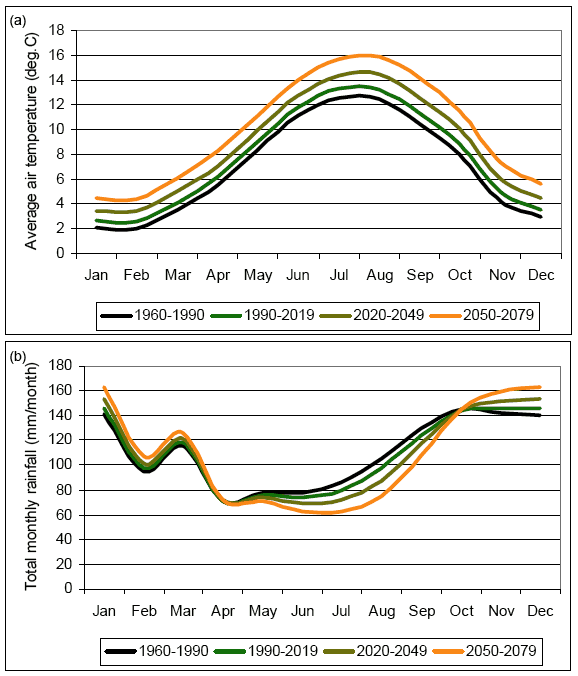
The UKCIP02 scenarios suggest the climate of Scotland will become warmer and drier as shown in Figure 4.2.17. The effect of the drying of the soil is exacerbated by a change in the distribution of rainfall, with a higher proportion of the rain projected to fall during the colder winter months when decomposition is already reduced by low temperatures (Figure 4.2.18). The changes in temperature and rainfall have opposing effects on the rate of soil organic matter decomposition. As the temperature increases, the rate of decomposition also increases, whereas as the rainfall declines, the soil dries out and the rate of decomposition slows down. The increasing annual temperatures result in more rapid decomposition of soil organic matter and so increased loss of soil C, whereas the drier summers slow the rate of decomposition, tempering the increase in soil C loss. Climate change alone is predicted to result in a decline in the soil C stocks of only -93 to -125 kt between 1990 and 2060 (-1.3 to -1.8 kt year -1). The largest changes in soil C are seen under unmanaged semi-natural land, -38 to -60 kt between 1990 and 2060 (-0.5 to -0.9 kt year -1). The model assumes that the C inputs from plants are maintained under climate change. If plant inputs are not maintained, as may be the case especially in semi-natural land uses, the losses of soil C will be greater than predicted.
Projected changes in land use result in larger predicted changes in soil C stocks than climate change: in 1990-1999, changes in climate result in C losses across Scotland of up to 181 kt C (10 years) -1, whereas projected land use change results in C losses nearly 50 times greater, up to 8222 kt C (10 years) -1. This is encouraging, as it illustrates the great potential for C losses due to climate change to be mitigated by changing land use.
Figure 4.2.16. Predicted changes in soil carbon stocks across Scotland for different land use changes as simulated by ECOSSE assuming soil disturbance on afforestation. Comparison of 2000- 2009 and 2010-2019
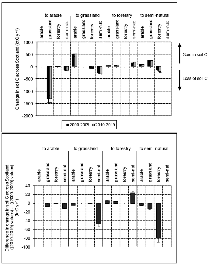
Figure 4.2.17. Predicted changes in climate across Scotland from UKCIP02 high scenario (a) average annual air temperature (b) total annual rainfall. Average across all 5km2 cells.
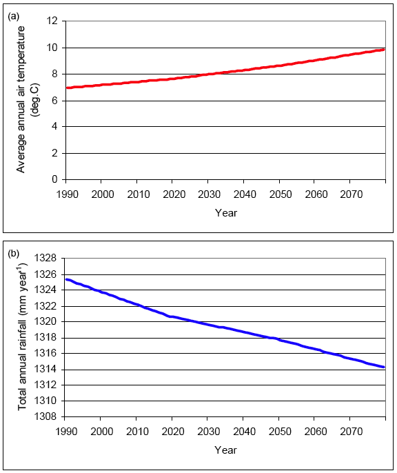
Figure 4.2.18. Predicted changes in climate across Scotland from UKCIP02 high scenario (a) average monthly air temperature (b) total monthly rainfall. Average across all 5km2 cells.
These simulations have assumed no land use change, and no changes to the plant C inputs to the soil. Changes in plant inputs will be superimposed on the effects of climate change. Note UKCIP02 scenarios were used because the UKCIP08 scenarios have not yet been published. In early 2009, the revised UKCIP scenarios are expected to be published, providing improved spatial resolution and updated climate scenarios. Simulations should be rerun with and without changes in land use and plant input when the new climate scenarios become available.
4.2.5. Mitigation options to reduce losses of soil C
Which mitigation options are most likely to reduce losses of soil C?
Figure 4.2.19 shows the potential of each land use change to impact the C emissions of Scotland. The potential to impact C emissions is calculated from the simulated change in total C emissions that occur when the given land use change is reduced to zero, and so accounts for both the area of predicted land use change and the size of the impact of the land use change on soil C stocks.
4.2.19. The impact of land use change on the carbon emissions of Scotland as estimated by ECOSSE.
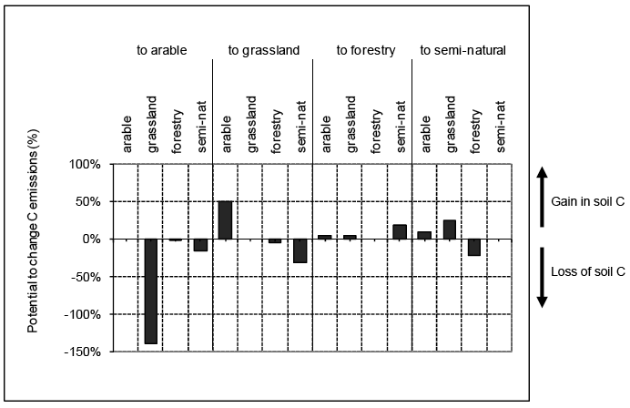
The land use change grassland to arable has most potential to reduce soil C losses. If the area of land converted from grassland to arable was reduced to 28% of its current rate of conversion, the soil C losses across Scotland would be reduced to zero; i.e. if in a given grid square the CEH prediction for conversion of arable to grassland from 2010 to 2019 was 100 ha, reducing the area of land converted from arable to grassland to 28 ha would reduce the losses of soil C such that the net losses of soil C across Scotland would be zero. However, given the current agricultural market, such a mitigation option may be unrealistic.
Other significant losses of soil C occur due to the conversion of semi-natural land to arable or grassland. The results suggest that if policies were designed to reduce conversion of semi-natural land to arable or grassland while maintaining the rate of conversion of semi-natural land to forestry, net losses of soil C could be reduced to as low as 53% of the current emissions. If this were coupled with an increase in the conversion of grassland to semi-natural land by 125% of the current rate of conversion ( i.e. increase 100ha conversion of grassland to semi-natural to 225ha), net losses of soil C would be reduced to zero. Alternatively, a 63% increase in the current rate of conversion of arable to grassland ( i.e. increase 100ha conversion of arable to grassland to 163ha) would also result in zero net losses of soil C when coupled with the reduced conversion of semi-natural land to arable or grassland. This could also be achieved by decreasing the current rate of conversion of grassland to arable to 77% of its current rate ( i.e. decrease 100ha conversion of grassland to arable to 77ha).
The results also suggest that conversion of semi-natural land to forestry would sequester additional soil C. However, the data in the national soils database does not currently account for the detail of changes in soil C likely to occur due to drainage and disturbance of semi-natural soils following afforestation. Due to the absence of better information, forested soils are described in the national soils database as a semi-natural soil (of the same soil type) with an additional litter layer added to the top of the soil profile. The analysis of NSIS data occurring as part of the core MLURI programme is providing a more accurate picture of the soil C content of forested soils. This information will be used in future work to revise the national soils database. Therefore, in the current study, conversion of semi-natural land to forestry was not included as a potential method to sequester soil C. Further work on the C content of forested soils and the changes occurring in soil C on afforestation is urgently needed.
Similarly, the results suggest that conversion of forestry to semi-natural land results in a loss of soil C, and so this land use change should be reduced. While a short-term loss of soil C is consistent with a reduction in soil C on disturbance of the soil as discussed in the previous sections, the data that provided this result is the estimate of the C content of forested soils from the C content of soil under semi-natural land use with a litter layer added to the top. No account is taken of the impact of possible changes in soil hydrology if drains are blocked on restoration of the land to its semi-natural state. Therefore, this result should not be used to suggest reduced conversion of forestry to semi-natural land as a mitigation measure. Further work is urgently needed on the C content of forested soils and the changes in soil C occurring on restoration of forested to semi-natural land.
These results suggest four mitigation options that would be effective tools for achieving zero net losses of C from Scottish soils:
1. Decrease in the rate of conversion of grassland to arable to 28% of the current rate;
2. Stop conversion of semi-natural land to arable or grassland and increase the conversion of grassland to semi-natural by 125% of the current rate;
3. Stop conversion of semi-natural land to arable or grassland and increase the conversion of arable to grassland by 63% of the current rate; and
4. Stop conversion of semi-natural land to arable or grassland and decrease the conversion of grassland to arable to 77% of the current rate.
The mitigation options were applied as a multiplication factor to the predicted land use changes for 2010 - 2019. The impact on the distribution of change in soil C stocks of applying these mitigation options is shown in figures 4.2.20 to 4.2.23.
Mitigation option 1 (reduce conversion of grassland to arable land) results in a reduction in the loss of soil C across the East coast and Central belt, while the losses on the West coast remain relatively unchanged.
Mitigations options 2, 3 and 4 (stop conversion of semi-natural land to arable or grassland and either increase grassland to semi-natural, increase arable to grassland, or reduce grassland to arable) all result in reduced loss of soil C across the West coast and smaller reductions on the East coast and Central belt.
These mitigation options represent simple changes to the amount of land use change occurring. In future work, more subtle changes in land use (such as changes in the distribution of crops, management of forestry, grazing of animals) could be applied in a similar way through modification of the land use types selected.
Figure 4.2.20. Simulated changes in soil C stocks in 2010 to 2019 as predicted by ECOSSE (a) no mitigation options applied; (b) rate of conversion of grassland to arable decreased to 28% of the current rate (mitigation option 1)
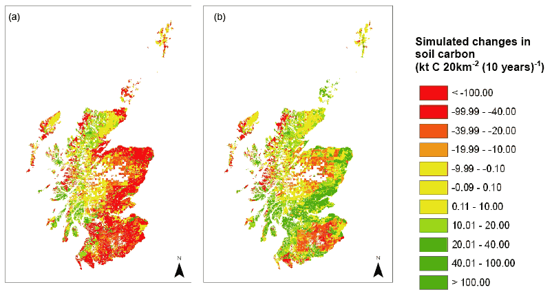
Figure 4.2.21. Simulated changes in soil C stocks in 2010 to 2019 as predicted by ECOSSE assuming a disturbance of the soil on afforestation (a) no mitigation options applied; (b) conversion of semi-natural land to arable or grassland and stopped and conversion of grassland to semi-natural increased by 125% of the current rate (mitigation option 2)
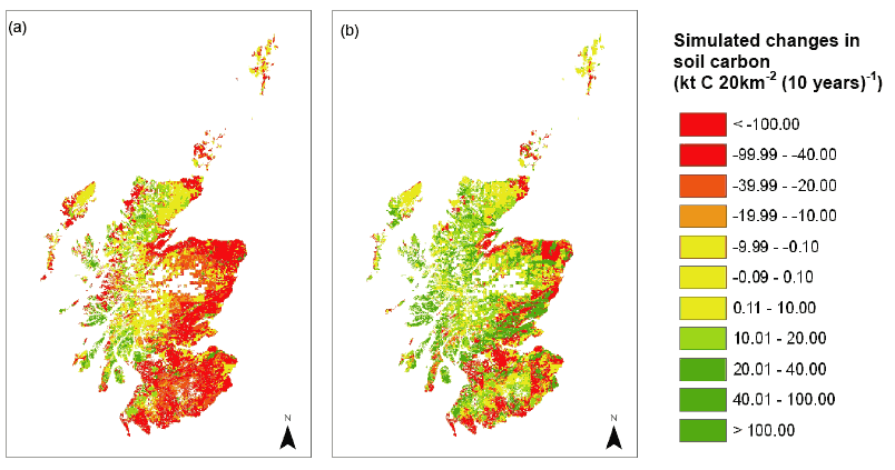
Figure 4.2.22. Simulated changes in soil C stocks in 2010 to 2019 as predicted by ECOSSE assuming a disturbance of soil on afforestation (a) no mitigation options applied; (b) conversion of semi-natural land to arable or grassland stopped and conversion of arable to grassland increased by 63% of the current rate (mitigation option 3)
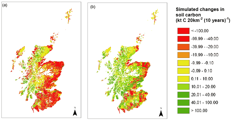
Figure 4.2.23. Simulated changes in soil C stocks in 2010 to 2019 as predicted by ECOSSE assuming a high level of disturbance on afforestation (a) no mitigation options applied; (b) conversion of semi-natural land to arable or grassland stopped and conversion of grassland to arable decreased to 77% of the current rate (mitigation option 4)
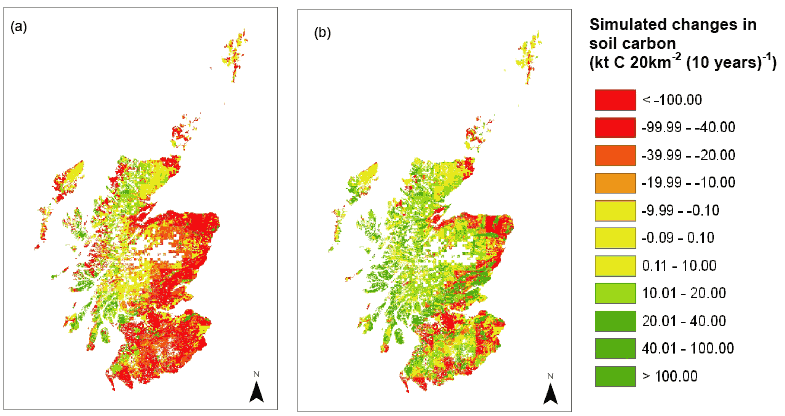
4.2.6 Conclusions
Comparison of CEH and ECOSSE estimates of change in SOC
The correlation between the ECOSSE and CEH estimates is given by r 2 = 0.97 and r 2 = 0.93 for 1990-1999 and 2000-2009 respectively, which is highly significant (P < 0.001). A t-test also indicates that the mean values estimated by the two approaches are not significantly different in either decade. This provides confidence that these two very different approaches are able to provide broadly similar results.
Soil disturbance and reduced plant inputs
The estimates of changes in soil C made by ECOSSE on land use change semi-natural to grassland show a larger loss of soil C than estimated by the CEH method. Similarly, ECOSSE estimates a larger gain in soil C on land use change grassland to semi-natural. Correspondingly, a larger loss of soil C is estimated by ECOSSE than by the CEH method for the land use change forestry to semi-natural and a smaller gain in soil C for the land use change semi-natural to forestry. These differences occur due to processes that are included in ECOSSE but not in the CEH approach associated with soil disturbance and reduced plant inputs when vegetation is immature. Carbon losses due to soil disturbance and an initial reduction in the plant input result in a loss of soil C or a smaller gain than estimated by CEH for land use changes between semi-natural land and grassland or forestry. A literature review provides evidence for the need to include soil disturbance and reduced plant inputs in simulations.
Changes in carbon attributable to Scottish soils
In 1990-1999, the ECOSSE estimate of the annual change in soil C stocks for Scotland is -822 kt year -1, differing from the CEH estimates by -9 kt year -1. In 2000-2009, the ECOSSE estimate of the annual change in soil C stocks for Scotland is -810 kt year -1, differing from CEH estimates by -68 kt year -1. These estimates show a high degree of agreement.
Land use changes responsible for the emissions
The simulated total change in soil C stocks becomes more negative ( i.e. increased emissions) from 1950s up to the end of the 1970s when the change in soil C stocks increases sharply ( i.e. decreased emissions), although remaining negative (net C emissions). The increase occurs due to a levelling off of the losses associated with the land use changes grassland to arable and forestry to semi-natural, and increased sequestration associated with conversion of arable land to grassland. Conversion of forestry to semi-natural results in net emissions up to the 1970s, because the plant communities have not had time to reach maturity. After this time, the greater maturity of the earlier converted land results in decrease in emissions. Increasing the area of land use change from arable to grass has the highest potential to sequester soil C, and decreasing the area of grass to arable has the highest potential to reduce losses of soil C.
Soils responsible for the emissions
Across Scotland, the simulated change in soil C from organic soils (defined here as soils with a C content of over 6%; Smith et al., 2007b) between 1950 and 2009 is -62512 kt, compared to -35351 kt from mineral soils; losses from organic soils are 64% of the total soil C losses. This emphasizes the importance of organic soils in any national estimates of greenhouse gas emissions, and the need to avoid C emitting land use changes on these soils. These results also suggest that mitigation options to reduce losses of soil C might recommend different policies for land use change on mineral and organic soils.
Changes in soil carbon due to projected land use change over the next decade
The largest difference in the C losses from the soil estimated for the next decade is associated with the land use change forestry to semi-natural, and is an additional loss of C from the soil of 80 kt C yr -1. The overall trend is towards increased loss of soil C, with a total loss of an extra 135 kt C yr -1 from the soil due to the projected scenarios of land use change in Scotland.
Changes in soil carbon due to projected climate change during this century
Climate change alone is predicted to result in a decline in the soil C stocks of only -93 to -125 kt between 1990 and 2060 (-1.3 to -1.8 kt year -1). The largest changes in soil C are seen under unmanaged semi-natural land, -38 to -60 kt between 1990 and 2060 (-0.5 to -0.9 kt year -1). If plant inputs are not maintained, as may be the case especially in semi-natural land uses, the losses of soil C may be greater than predicted. Projected changes in land use result in losses of soil C stocks that are nearly 50 times greater than the losses due to climate change. This illustrates the potential for C losses due to climate change to be mitigated by changing land use.
Mitigation options to reduce losses of soil C
Four mitigation options were identified as potential tools for achieving zero net losses of C Scottish soils:
1. Decrease in the rate of conversion of grassland to arable to 28% of the current rate;
2. Stop conversion of semi-natural land to arable or grassland and increase the conversion of grassland to semi-natural by 125% of the current rate;
3. Stop conversion of semi-natural land to arable or grassland and increase the conversion of arable to grassland by 63% of the current rate; and
4. Stop conversion of semi-natural land to arable or grassland and decrease the conversion of grassland to arable to 77% of the current rate.
Contact
Email: Central Enquiries Unit ceu@gov.scot