Sectoral marine plan: regional locational guidance
Sets out regional spatial baseline data for the sectoral marine plan for offshore wind energy and describes the information used in the planning and assessment process.
6 East
6.1 Introduction
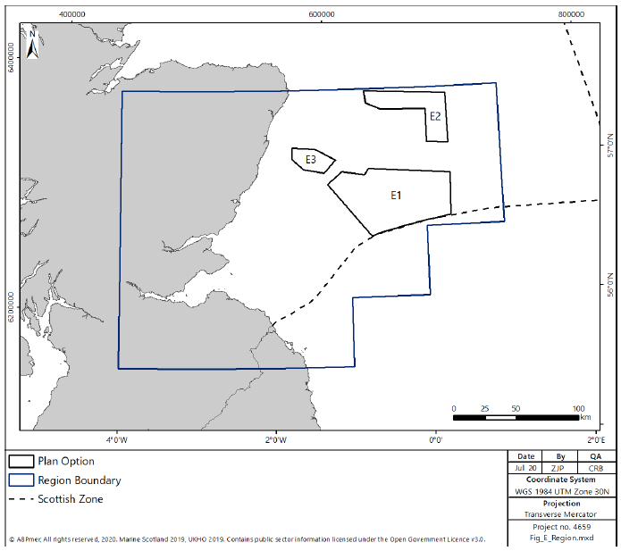
6.1.1 The East region incorporates the area from the southern edge of the North East region at Peterhead, to the border with England, including the Firths of Forth and Tay (Figure 185). The region extends seawards to the east to include the three Plan Options in the region, as shown in Figure 185.
6.2 Physical Considerations
Offshore Wind Resource
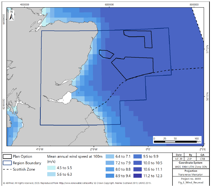
6.2.1 Within the East region, encompassing three Plan Options (E1, E2 and E3) there is considerable available resource as shown in Figure 186 using the annual wind speed as a proxy, and calculated in Table 5 for the three Plan Options.
| Area of Search | Region | Area (square km) | Potential Installed capacity (GW) | Realistic Maximum Development Scenario (GW) |
|---|---|---|---|---|
| E1 | East | 3742 | 18.7 | 3 |
| E2 | East | 1287 | 6.4 | 2 |
| E3 | East | 474 | 2.4 | 1 |
| East Total | 5503 | 27.5 | 6 | |
Grid Connection
6.2.2 Within the East region there is good capability to support current offshore wind development with 275 kV and 400 kV networks developed in the region to support current offshore wind and Torness power station. However, National Grid identify the strong potential for future requirements to further reinforce the grid in the area as future offshore wind developments reach fruition[311], particularly given the likely transmission through the region required to support renewable energy developments in the North and North East regions.
6.2.3 It is noted that with the future decommissioning of the Torness nuclear power station (2030) there may be future potential for excess capacity on the Grid within the East region which could support development of offshore wind in the region.
Bathymetry and Seabed
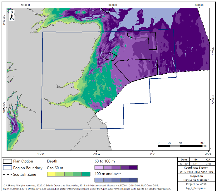
6.2.4 Within the East region the water depths are almost entirely less than 100 m, shown in Figure 187, with an area of shallower water less than 60 m extending out from the Firth of Forth. The water depths within the Plan Options are mostly between 60 and 100 m with a small area of E3 over 100 m deep.
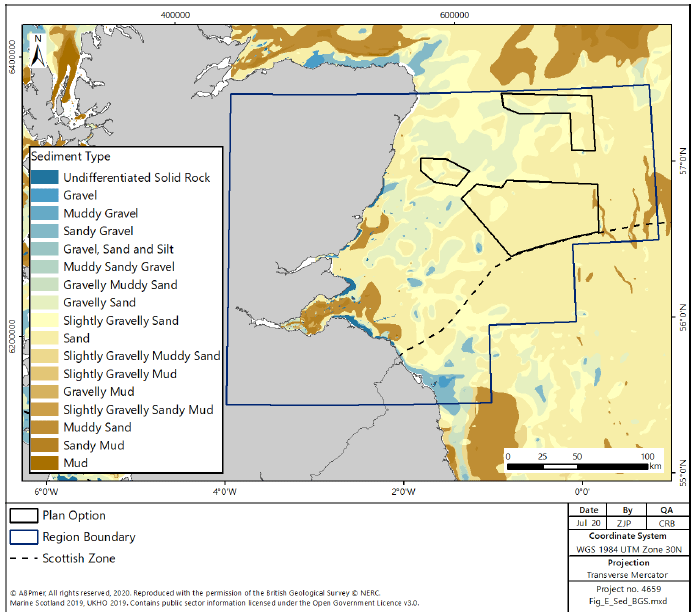
6.2.5 Sediment within the region, as shown in Figure 188, is, similar to the North East, dominated by sand, with some smaller areas of coarser sediment towards the coastline and muddy sediment within and extending out of the Firth of Forth. Similarly, the sediment within the Plan Options is generally sand, with some small areas of coarser sediment within E2 and E3.
6.3 Socio Economics
Supply Chain
6.3.1 Five locations are identified in the East region[312] which could be developed to support the construction, operation and maintenance of offshore wind in the Plan Options. These are:
- Peterhead - distributed manufacturing and operation / maintenance;
- Aberdeen - distributed manufacturing and operation / maintenance;
- Dundee - distributed manufacturing and operation / maintenance;
- Energy Park Fife at Methil - further manufacturing; and
- Leith - integrated manufacturing.
6.3.2 In addition, there are a number of sites in other regions discussed within the specific regional text, particularly the North East region, that have the potential to support the development of offshore wind in the East region.
6.3.3 Infrastructure at Peterhead is currently used to support the oil and gas industry, particularly O&M activities. It is therefore well placed to transfer the skills within the current workforce, as oil and gas within the North Sea is decommissioned, to support the offshore renewable industry.
6.3.4 As for Peterhead, infrastructure at Aberdeen is currently principally used to support the oil and gas industry, particularly Operation and Maintenance, and as a result is well placed to transfer the skills within the current workforce to support the offshore renewable industry. Vattenfall, an energy developer, has established an operations and maintenance base within Aberdeen to support the European Offshore Wind Deployment Centre.
6.3.5 Dundee has been identified by the NRIP as having the potential to support offshore wind manufacturing, through the development of land suitable for a manufacturing facility, however no development has been undertaken to date.
6.3.6 Energy Park Fife at Methil currently supports the offshore wind industry, with companies located on the site undertaking manufacture of components for offshore wind sites currently under development, including the Beatrice wind farm in the North East region. There is therefore significant potential for the manufacturing facilities on the site to support future development of offshore wind both in the North Sea and further afield.
6.3.7 Leith was identified in the NRIP as having the potential to support large scale manufacturing, installation activities and operation and maintenance activities within the offshore renewables industry.
Energy Generation
6.3.8 There are two power stations located within the East region. Peterhead (Combined Cycle Gas Turbine), located on the border between the North East and East regions, and Torness nuclear power station on the coast to the south of the Firth of Forth. The Torness nuclear power station is currently proposed to cease generation in 2030.
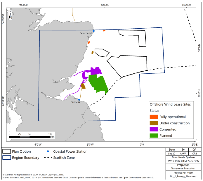
6.3.9 There is currently no proposed or identified potential for wave or tidal energy generation in the East region. In 2013 the Marine Scotland consulted on Plan Options for wave and tidal energy[313,314]. These DPOs were subsequently recognised in Scotland’s National Marine Plan[315]. There are no wave or tidal energy DPO areas identified within the East region (Figure 189).
6.3.10 Offshore wind is currently being developed in the East region, with three major developments (Seagreen (1500MW), Inch Cape (600MW) and Neart na Gaoithe (450MW)) identified in the outer Firth of Forth and Firth of Tay, inshore of the proposed Plan Options, as shown in Figure 189. The Firth of Forth (Seagreen) windfarm is consented for Phase 1, however it is currently applying for a variation of consent to update the proposed technology. The Neart na Gaoithe and Seagreen phase 1 projects have both secured Contracts for Difference.
6.3.11 There are additional small sites offshore of Aberdeen (European Offshore Wind Farm (93.2MW), fully commissioned; and Kincardine (50MW), under construction), Peterhead (Hywind (30MW) fully commissioned) and Methil (12MW) on hold).
Power Interconnectors
6.3.12 There are no power interconnectors in the East region, however there is a proposed Eastern HVDC which may, in future (around 2028), connect Peterhead on the northern border of the region with north east England, but this project is currently classed as dormant[316].
Telecom Cables
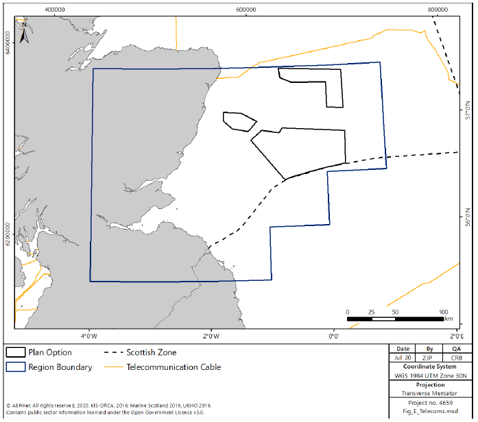
6.3.13 The East region has few active telecom cables (41km), with just a short stretch coming off the coast from Aberdeen. None of the Plan Options are near telecom cables (see Figure 190).
Carbon Capture and Storage
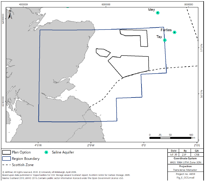
6.3.14 The current development of the potential carbon and capture industry in Scotland is centred around the North East and East regions with the sole proposed development by ACT Acorn using existing Oil and Gas infrastructure to transport CO2 from St Fergus, near Peterhead (approximately on the boundary between the two regions) north-east to the Captain Sandstone saline aquifer (Figure 191).
6.3.15 It is therefore likely that the majority of the potential economic benefits associated with the development of a CCS industry will be realised within the North East and East regions.
6.3.16 The Captain aquifer currently identified for development does not directly overlap with any of the Plan Options identified in the East region, although there are further saline aquifers in the seas further offshore to the east of E2, which in future may have the potential to support CCS development.
Oil and Gas
6.3.17 In the East region oil and gas activity is concentrated in offshore waters (see Figure 192). There are 17 producing hydrocarbon fields in the region (all producing oil).
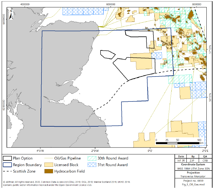
6.3.18 E1 and E2 both overlap with licensed blocks[317].
Aviation
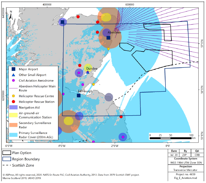
6.3.19 The East region has two major airports, three civil aviation aerodromes and three helicopter rescue stations (see Figure 193).
6.3.20 Aberdeen is an international airport which offers a wide variety of destinations. The airport also serves the offshore industry which means it has frequent helicopter flights[318], the routes for which go directly through E1 and E3 proposed areas for development. A large portion of the East region (including E1 and the western corner of E2 and E3) is covered by the primary surveillance radar used by Aberdeen airport.
6.3.21 Edinburgh is Scotland’s busiest airport and had over 9.4 million passengers passing through its terminal in 2016.
6.3.22 Dundee is also an important airport for the East region and is used for scheduled, private and chartered flights.
6.3.23 Aberdeen and Edinburgh airports are safeguarded civil aerodromes.
Defence
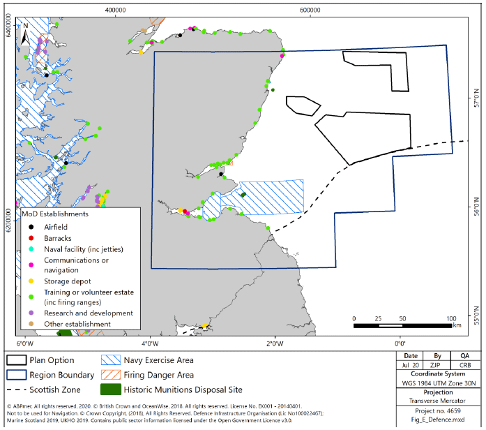
6.3.24 There is a high concentration of defence assets in the East region used for free navigation for surface and subsurface naval vessels for national defence; safeguarding of navigational routes and nationally critical infrastructure; designated Danger Areas and Exercise Areas for military training and defence test & evaluation purposes; retain strategic maritime infra-structure, installations and coastal MOD facilities.
6.3.25 None of the Plan Options in the East region are within or overlap with firing danger areas or Navy exercise areas (Figure 194). In addition to military establishments in the public domain, it is recognised that further military assets may be present in the region. Any concerns regarding assets of this type will be identified in consultation with the MOD at a project level.
6.3.26 The MOD support a number of jobs in the East region, both directly and indirectly. Employment is largely through the Leuchars Station army facility and through ship-building facilities in the Firth of Forth related to the construction of the Queen Elizabeth class aircraft carriers. No regional breakdown of employment figures are available within Scotland, however it is likely that an appreciable portion of the direct and indirect employment figures discussed in the national overview above are located in the East region.
Fishing
6.3.27 Landings from UK-registered vessels caught in the East region had an average annual value of £113 million and an average live weight of 9,966,151 tonnes for the five year period 2013-2017.
6.3.28 The majority of landings were shellfish (46%) and demersal species (34%) with the vast majority of landings by the over 12 m fleet (95%). The main gear types were demersal trawls (41%), mechanical dredges (35%) and midwater trawls (15%).
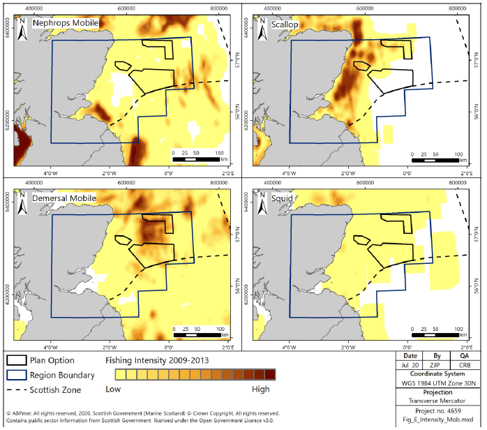
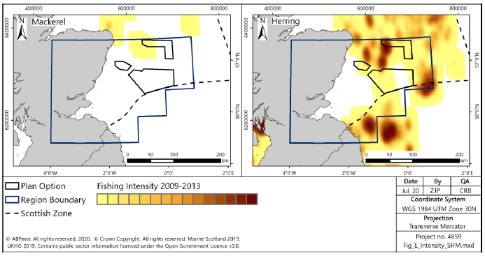
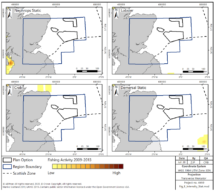
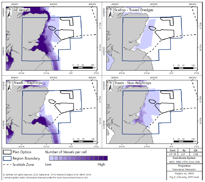
6.3.29 Figure 195 shows over-15m fishing intensity by mobile demersal gears, which operated across the region in 2009–2013. Nephrops trawls operated outside the Firth of Forth, particularly between Eyemouth and Anstruther, while scallop dredgers operated from Arbroath to Peterhead. Over-15m pelagic vessels operated at a lower intensity in the region, although there was some patchy herring fishing in the northern, eastern and southern parts of the region (Figure 196). Fishing by over-15m vessels using static gear was minimal or absent from the region (Figure 197).
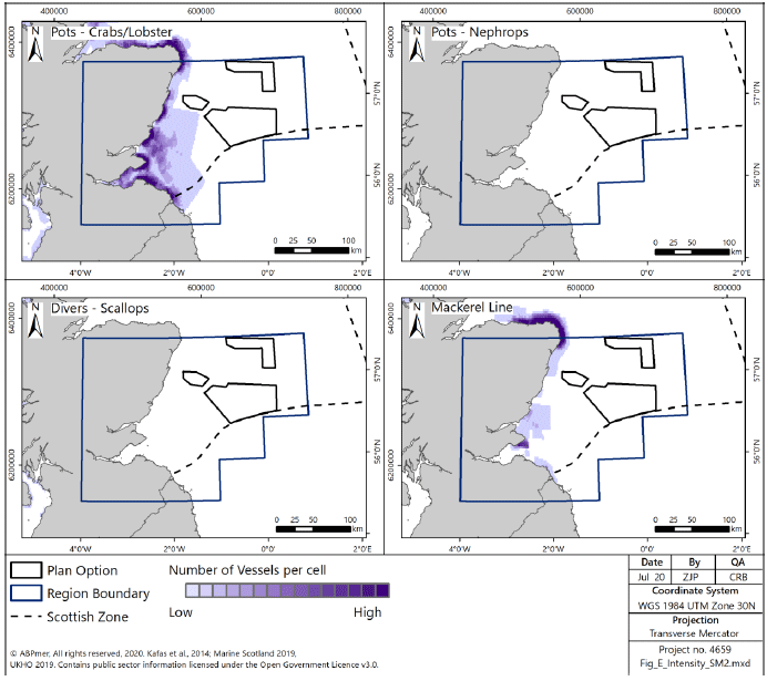
6.3.30 Areas important for under-15m vessels are the Firth of Forth (mostly Nephrops trawls), and from Pittenweem to St Andrew’s Bay and along the coast from Arbroath to Stonehaven (crab/lobster creels) (Figure 198, Figure 199).
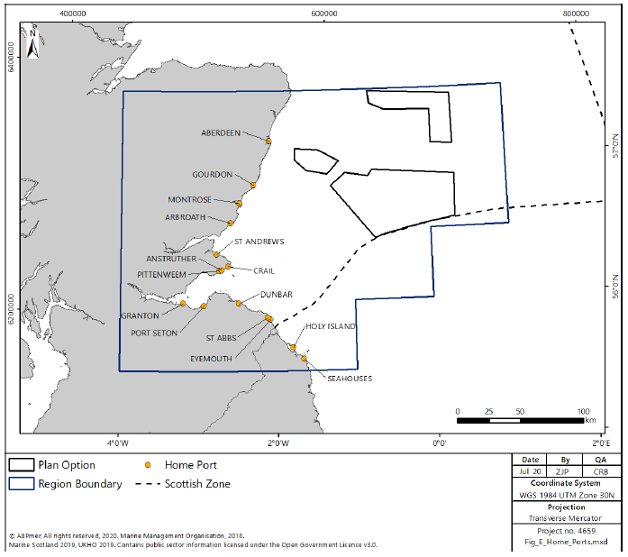
6.3.31 There were 266 fishing vessels with their Home Port registered within the East region in 2016[319]. This region had this highest proportion of under-10 m vessels of all the regions (85%), and only 3% of vessels were over-15m in length. The ports with the most registered vessels were Eyemouth (60), Pittenweem (56), Aberdeen (40), Gourdon (10) and Seahouses (10). Home ports within the East region are shown in Figure 200.
6.3.32 The main landing ports (in terms of value of landings in 2017) in the East region are Pittenweem (£3.5 million), Eyemouth (£2.7 million) and Arbroath (£1.9 million)[320].
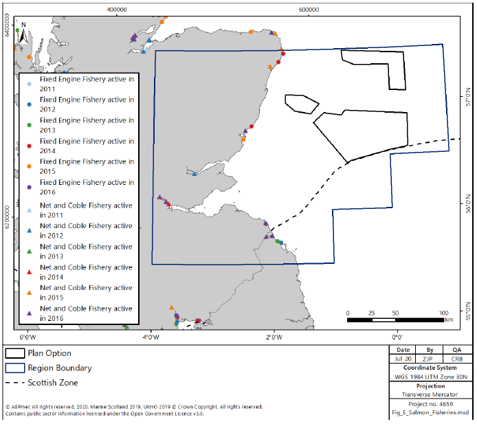
6.3.33 There are five fixed engine sites for wild salmon and sea trout, around Peterhead, Montrose and Eyemouth, and six net and coble sites near Peterhead, Montrose, Firth of Tay and Firth of Forth (Figure 201).
6.3.34 The main rod and line fishing rivers in this region are the Rivers Carron (salmon), Don (salmon and sea trout), Dee (salmon and sea trout), North Esk (salmon), South Esk (salmon and sea trout), Tummel (salmon), Tay (the largest of Scotland’s salmon rivers), Earn (salmon and sea trout), Alan (salmon and sea trout), Teith and Forth (one of the best salmon rivers in Central Scotland), Tyne - East Lothian (sea trout), Whiteadder (salmon and sea trout), Tweed (salmon and sea trout) Teviot (salmon and sea trout), Ettrick and Yarrow (salmon)[321].
Aquaculture
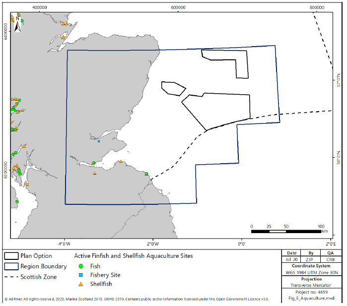
6.3.35 There are very few aquaculture facilities in the East region (3 licensed finfish and 4 shellfish installations) and none in or close to the Plan Option sites (see Figure 202). There is a presumption against aquaculture currently in place on the east coast.
Ports and Harbours
6.3.36 In the East region there are 6 major ports, 2 minor ports and many smaller harbours (see Figure 203).
6.3.37 Aberdeen is a large commercial port, supporting the oil and gas industry and cargo transport. The NRIP explored scope for using sites at the port for further development to allow for wider vessels and construction of facilities onshore. It was included in phase one sites for distributed manufacturing and operation/maintenance.
6.3.38 Dundee port was identified in the NRIP for distributed manufacturing, operation and maintenance related activities. It expects that the port will play a significant role in supporting renewable energy development and investment, given the suitability of its facilities.
6.3.39 Leith port is the largest enclosed deep-water port in Scotland. It handles general cargo and cruise liners. The NRIP stage 2 report identifies Leith as a strong location for large-scale manufacturing, installation activities and operations and maintenance for the renewables industry.
6.3.40 Grangemouth is Scotland’s largest container port, located towards the westernmost extent of the Firth of Forth and handles approximately 150,000 containers per annum.
6.3.41 Rosyth is located on the north bank of the River Forth and provides support for freight ferry services and cargo transport, including timber, bulk salt, rapeseed meal and animal feed.
6.3.42 There is a high concentration of anchorages in the Firth of Forth and the Firth of Tay reflecting the high level of sailing activity in the area. None of the anchorages overlap with the Plan Options.
6.3.43 There are a few dredge disposal sites in the region. They are all close inshore and do not overlay with the Plan Options.

Shipping
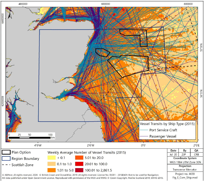
6.3.44 Areas of high shipping density, up to 100 vessels per week, (Figure 204) in the East region are generally concentrated around the Firth of Forth and the Firth of Tay (with a smaller hotspot around Montrose) in the southern half, and around Aberdeen and Peterhead in the north. Much of the traffic offshore from Peterhead and Aberdeen is linked to the oil and gas industry, with the port service craft transit lines emphasising these movements. In addition, there is a line of high density offshore from the Firth of Forth but inshore from E3 with up to 20 vessel transits per week linking ports in England to Aberdeen and areas further north. The majority of the traffic tends to be relatively close inshore around the Firth of Forth and is associated with the East coast route from England linking to Edinburgh.
6.3.45 As identified in the North East region above, ferry services from Aberdeen link to the Orkney Islands and the Shetland Islands, providing lifeline services. The majority of these movements within the East region is close to shore to the north of Aberdeen with no interaction with the Plan Options.
6.3.46 The Plan Options further offshore are generally in areas of lower shipping density, however Plan Option E3, closer to Aberdeen, has the potential to interact with a wide range of shipping, including oil and gas related activity and routes across the North Sea to Europe, some of which may also interact with Plan Options E2 and E1.
Coastal and Flood Protection
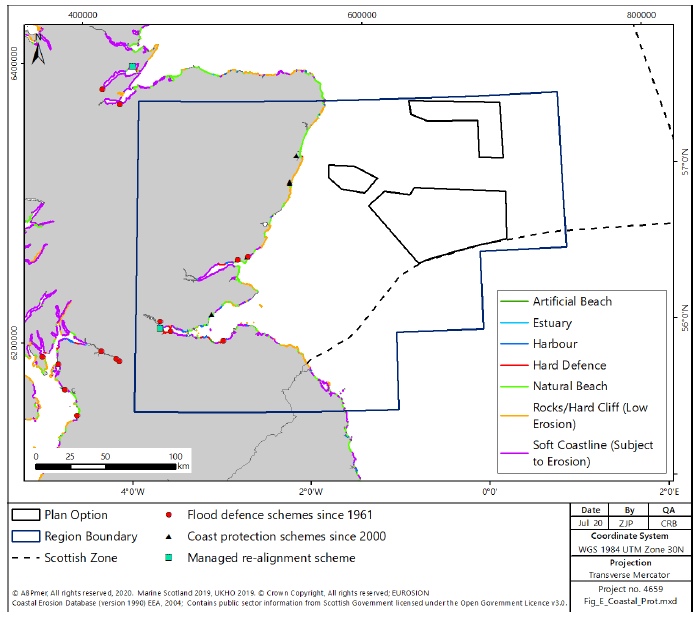
6.3.47 There are a few areas of Coastal and Flood protection in the East region that have been developed since 1961, shown on Figure 205, although extensive sections of the Firth of Forth and Firth and Tay estuaries have protection works. The more recent developments are mostly concentrated around the Firth of Forth and the River Tay estuary with two further areas of coastal protection to the west, directly inshore of, Plan Option E3. There are some further areas of hard defence within the East region, generally associated with harbour infrastructure.
Marine and Coastal Recreation
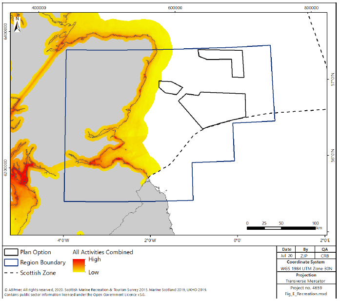
6.3.48 Overall recreational activity in the East region is shown in Figure 206. Most recreational activity occurs inshore of the Plan Options, although there is some potential interaction with sailing and cruising routes in the region. There is some overlap between E3 and low-levels of recreational activity. However, the data show that there is no known overlap with E2 and E1.
Boating
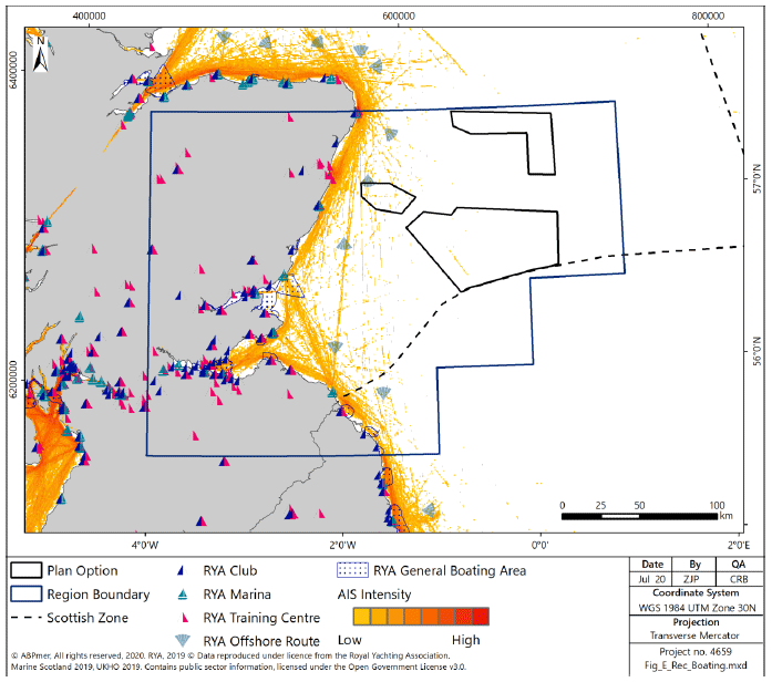
6.3.49 Sailing and racing are popular in the East region and occur in the Firth of Tay, Firth of Forth and along the Southern section of coastline (Figure 207). Recreational use is centred on the Firth of Forth, Firth of Tay and St Andrew’s Bay, with moderate use cruising routes extending up and down the coastline from these areas. There many marinas, clubs and training centres along the coast, including at Port Edgar and Arbroath. Whilst there is no or very low interaction between boating with Plan Options E1 and E2, there is likely to be some, albeit low-medium-scale overlap with E3 and boating.
Angling
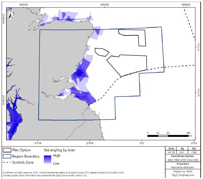
6.3.50 Sea Angling is undertaken along much of the coast of the East Region such as the Firth of Tay and East Lothian coast (Figure 208). The available data show that this is not occurring throughout the Plan Options, however, some there is some activity inshore of E3, and therefore angling may occur in this area.
Diving
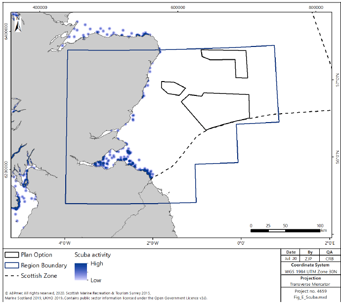
6.3.51 Many dive sites are found in the East region with particularly high densities of sites near St Andrews, Firth of Forth and the Berwickshire coast (Figure 209). In particular, the voluntary Marine Reserve of St. Abbs Head and Eyemouth is one of Scotland’s most popular dive locations attracting thousands of people each year. This area of Scotland is highly populated, and this is reflected in a large number of clubs and dive centres operating. There is no recorded activity occurring within the Plan Options.
Sea Kayaking and Canoeing
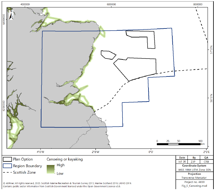
6.3.52 The majority of trips are close inshore. Kayaking and canoeing takes place at most spots along the east coast where there are suitable launching spots such as beaches and slipways. Areas of high activity density include regions around Aberdeen, Edinburgh, the East Lothian and Borders coastlines (Figure 210). There is no recorded sea kayaking or canoeing activity occurring within the Plan Options.
Surfing and Windsurfing
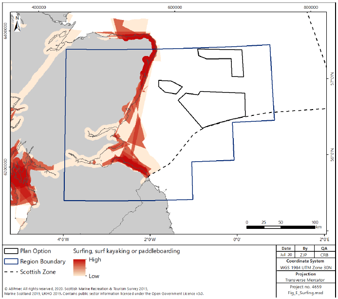
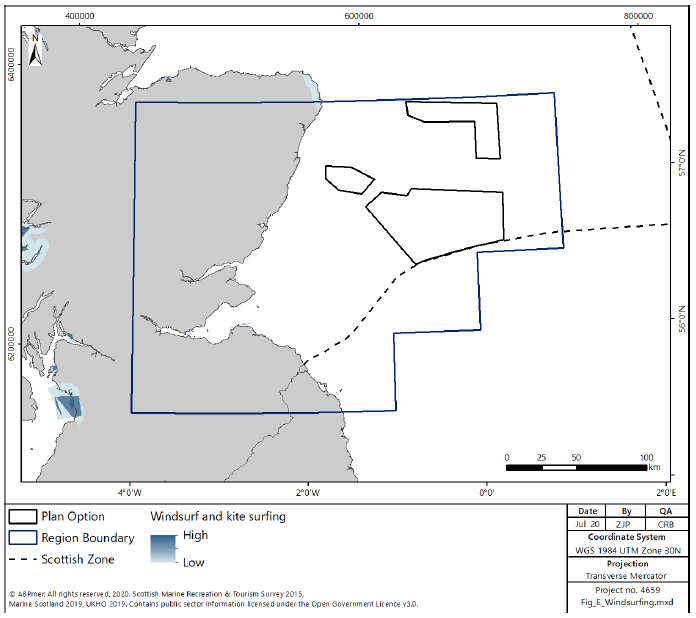
6.3.53 The East region is the least consistent area for surf, with medium quality waves of medium popularity. It receives long-swell from the North Sea and most of the breaks are beach breaks[322]. The most popular locations include; Arbroath, Belhaven Bay, Coldingham Bay, Cruden Bay, Kingsbarns, Lunan Bay, Nigg Bay, Pease Bay, Peterhead, Seacliff and St Andrews[323] (Figure 211). The available data show that there is no recorded surfing or windsurfing activity occurring within the Plan Options. However, some activity has been recorded inshore of E3. There is limited windsurfing activity in the North East region, with the area of highest density within the Firth of Forth (Figure 212).
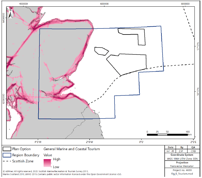
Tourism
6.3.54 Tourist sites in the East region include accommodation and camping facilities, general tourist attractions, historic/heritage attractions, natural heritage attractions, transport and travel related facilities. Although sites are scattered throughout the region, there is a high density of sites along the coast, particularly in the Firth of Forth. This would be expected, given the proximity to Edinburgh. The Firth of Forth also has several cultural and maritime heritage assets, including a historic ship, sites designated under the Protection of Wrecks Act, a maritime museum and several listed buildings.
6.3.55 The East region has three big cities situation along the coast; Edinburgh, Aberdeen and Dundee. These are popular tourist destinations, but also important travel hubs and tourism activity is therefore centred in these locations (Figure 213).
6.3.56 The presence of Blue Flag Beaches, designated bathing waters also encourages tourists to visits the East regions beaches. Beach users are likely to be an essential group to remember when considering the development of offshore renewables.
6.3.57 The East region has three areas designated as Marine Special Areas of Conservation, namely: Firth of Tay and Eden Estuary, Isle of May and part of Berwickshire, and Northumberland SAC. These SACs attract visitors for marine and coastal wildlife tourism.
Social Considerations
6.3.58 The total population of the East region is approximately 1,860,000 using data for Aberdeen City, Aberdeenshire, Angus, City of Edinburgh, Dundee City, East Lothian, Fife and Scottish Borders Scottish council areas. The overall average age is 41 for the East region. Under 16’s make up 17% of the population, 65% of the population is of working age and 18% of the population in the East region is pension age[324].
6.3.59 In 2017 there was an 75.1% employment rate in the East region. The greatest number of jobs in the East region are associated with public admin, education and health (30%). Other important industry sectors are distribution, hotels and restaurants (19%), and banking and finance (16%). Aberdeen City and Aberdeenshire also have a high number of jobs (16%) in the energy and water sector[325].
6.3.60 The Scottish Index of Multiple Deprivation (SIMD) shows that most of Aberdeenshire, which makes up a large portion of the East region, is in the 5% most access deprived areas in Scotland[326].
6.4 Environment
Designated Sites
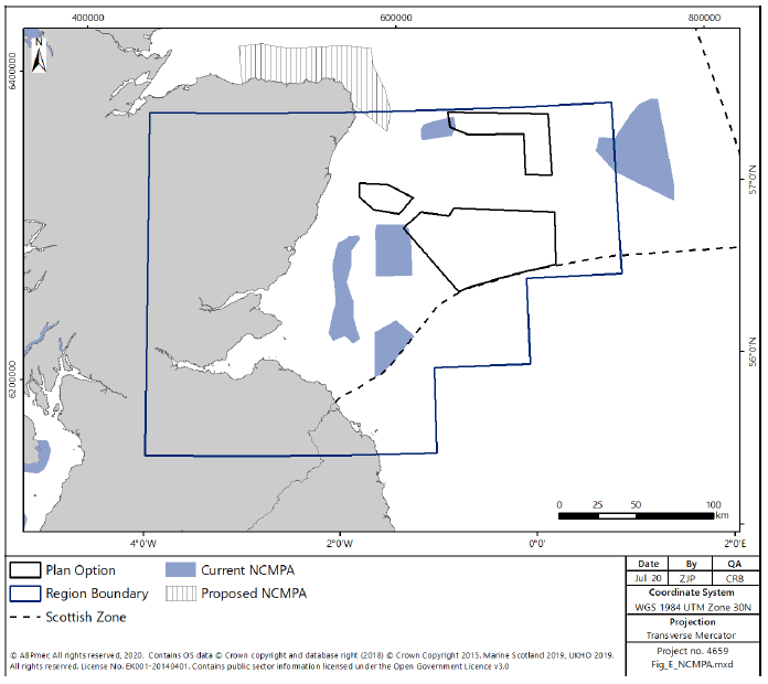
6.4.1 Within the East region there are a range of designated sites, shown in Figure 214, Figure 215, Figure 216 and Figure 217 including 4 NCMPAs (including one pNCMPA), 11 SPAs (including 2 pSPAs), 3 SACs and 18 SSSIs.
6.4.2 There are two areas of overlap between designated sites and the proposed Plan Options in the East region. Areas within the Firth of Forth Banks complex NCMPA, designated for ocean quahog aggregations and offshore subtidal sands and gravels, overlaps with E1. The Turbot Bank NCMPA, and the proposed Southern Trench MPA designated for Sandeels, also overlaps with the western extent of E2.
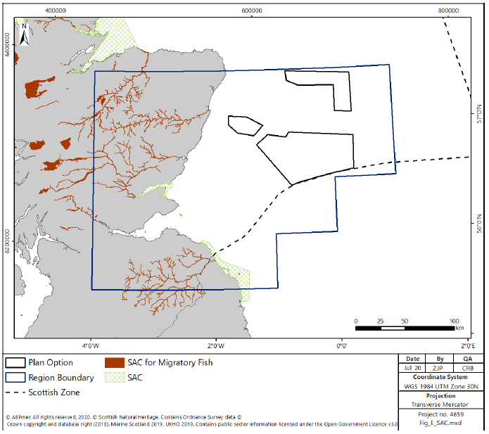
6.4.3 There is one SAC within the East region, the Berwickshire and North Northumberland Coast SAC, designated for grey seal, intertidal mudflats and sandflats, reefs, sea caves and shallow inlets and bays. The SAC is approximately 65km to the south and southwest of Plan Option E1.
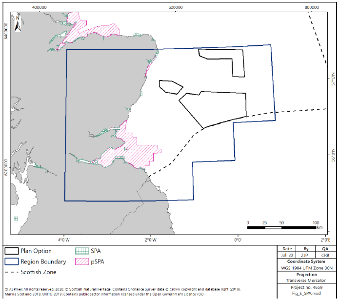
6.4.4 There are several SPAs currently designated within the East region, located near the coastline and onshore and designated for a range of seabird and terrestrial species features and assemblages which may use the sea within the Plan Options for feeding and / or during migration. There is a large pSPA proposed to cover the Firth of Forth and areas of sea and coastline to the north and south of the Firth, proposed for designation for a wide range of breeding and non-breeding seabird and waterfowl populations. Further detail on seabird species distributions is contained within the Birds section below.
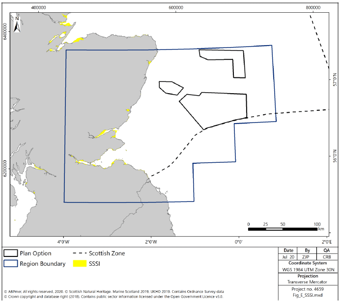
6.4.5 The 18 SSSI are located across the East region and are protected for a range of features, including geology, habitats and species. Some, although not all, SSSI sites overlap with European SPA or SAC designations.
6.4.6 In addition to the sites identified within the boundaries of the East region, there may be more remote designated sites which may have the potential to be affected by offshore wind developments within the Plan Options. This would be considered on a project by project basis.
Water and Sediment Quality
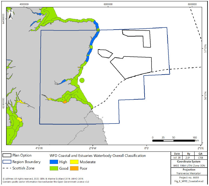
6.4.7 WFD monitoring incorporates coastal and transitional waters in the marine environment. There are no overlaps between the Plan Options and classified water bodies within the East region. The water bodies in the East region are shown in Figure 218. The majority of the coastal water bodies in the northern extent of the East region are classified as high status[327], with the majority of the water bodies in the southern extent classified as good. There are two water bodies in the East region below good status, one (Middle Forth Estuary) at moderate condition, the other (Leith Docks to Port Seton) is currently classified as poor due to poor ecological potential and morphology.
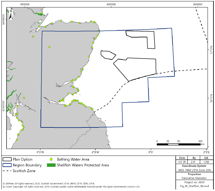
6.4.8 There are no areas of protected waters for shellfish production in the East region.
6.4.9 There are a large number of classified bathing waters in the East region (Figure 219). Of the 45 designated bathing waters in the East region, 15 are at excellent status, 25 are at good status or at target objective and 5 are currently classified as poor.
Benthic Habitats and Species
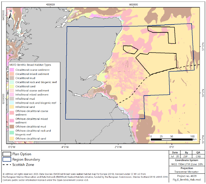
6.4.10 As identified in Section 6.2 above and on Figure 220, the benthic habitats in the East region are characterised by muddy sediments within the Firth of Forth, with gravelly sediment beyond before graduating through sand generally within the region of the Plan Options to muddier sediments further offshore. The Plan Options within the East region are all characterised by sandy sediments with some small areas of mixed sediments.
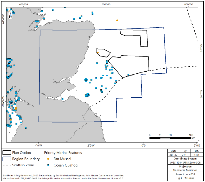
6.4.11 There is limited diversity in the benthic species present in the East region. The key PMF species present within the East region are ocean quahog, with some records of fan mussel. The ocean quahog records, shown in Figure 221, are principally inshore of the Plan Options to the east of the Firth of Forth (E1). The one record of fan mussel within the East region falls within E3, as shown on Figure 221.
6.4.12 In addition to the PMFs present within the Plan Options there are PMF supported by benthic habitats landwards of the Plan Options, including further seagrass, sea pens, fireworks anemone, maerl and ocean quahog.
Fish
6.4.13 There is generally lower species richness and diversity amongst the fish population in the East region in comparison to that found in the North and West regions. There are, however, a number of species within the region that are important commercially, as discussed in Section 6.3 above.
6.4.14 There are a number of migratory fish which migrate through the seas within the East region into the estuary and riverine environments, including Atlantic salmon and sea lamprey. The migration routes for returning salmon (Figure 45 in Section 2.3 shows the approximate routes, although should not be used to infer “safe” zones) indicate there is potential for the routes to intersect with the Plan Options, particularly when transiting from the North Sea into the Firth of Forth.
6.4.15 Usage of the seas within the East region by shark species is also generally lower than for the West and North regions, although a number of elasmobranch species, including small numbers of basking sharks, rays and other shark species, are known to frequent the region with small numbers of sightings in the Firth of Forth.
6.4.16 The East region also is an important spawning ground for fish species including herring, cod, whiting and plaice with some high-intensity spawning grounds for sandeels; high-intensity nursery grounds for herring, whiting, cod and low-intensity nursery grounds for ling, mackerel, plaice, anglerfish, sandeels and hake. Whilst there is a lack of data available to show available spawning sites for elasmobranch species, there are many known nursery ground areas in the area, which overlap the Plan Options, including spurdog, tope, common skate, spotted rays, with high-intensity nursery grounds for spurdog and neighbouring common skate nursery grounds[328].
Marine Mammals
6.4.17 The distribution and species richness of the East region marine mammal population is similar to that described for the North East in Section 5.4.
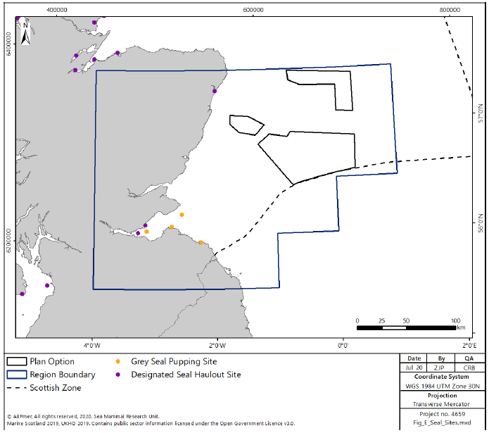
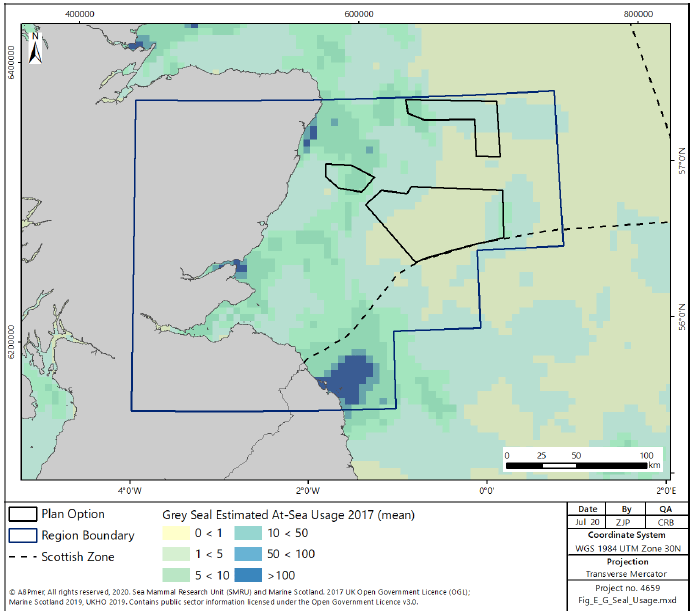
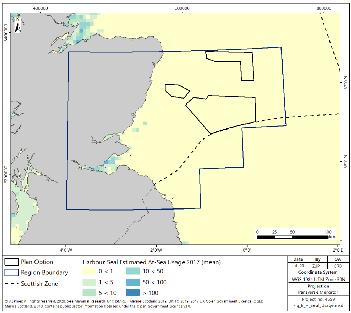
6.4.18 Both grey and harbour seals are present in the area, concentrated around breeding populations in the Firth of Forth (Figure 222 for breeding and haulout sites and Figure 223 and Figure 224 for grey and harbour seal distributions respectively). The grey seal populations are known to forage further offshore than harbour seals, the sea usage of which is generally limited in the East region to the Firth of Forth. As a result, the grey seal is considerably more likely to interact with the Plan Options, and there is some overlap of medium sea usage within E1, with higher sea usage in E3 and the western end of E2.
6.4.19 Cetacean usage of the seas in the East region is similar to that of the North East with high encounter rates of harbour porpoise, bottlenose dolphin, white beaked dolphin and minke whale[329]. In addition, there are wider areas in the east region where encounters with Atlantic white-sided dolphin are recorded.
6.4.20 The Firth of Tay has been identified as an area of high concentration of bottlenose dolphin[330], although survey effort was concentrated close to the coastline and therefore does not overlap with the Plan Options.
6.4.21 There are two riverine environments within the East region identified as important for otter populations (River Dee), The mouth of the river in Aberdeen is approximately 15km inshore of Plan Option E3, with all other Plan Options further in distance from any areas identified for otter usage. The nature of the Plan Options offshore and in deeper water suggests that there is unlikely to be any direct interaction between otter populations and offshore wind developments, however siting of cable landfalls have the potential to intersect otter habitat.
Birds
6.4.22 The importance of the East region to birds is demonstrated in the designation of 9 SPAs and the further 2 proposed SPAs with marine elements with additional terrestrial sites, as discussed above.
6.4.23 There are both breeding and non-breeding populations of a wide variety of seabirds in the East region. Several significant seabird colonies are found around the coastlines, particularly on the coastline to the north and south of Aberdeen, and in the southern extent of the Firth of Forth.
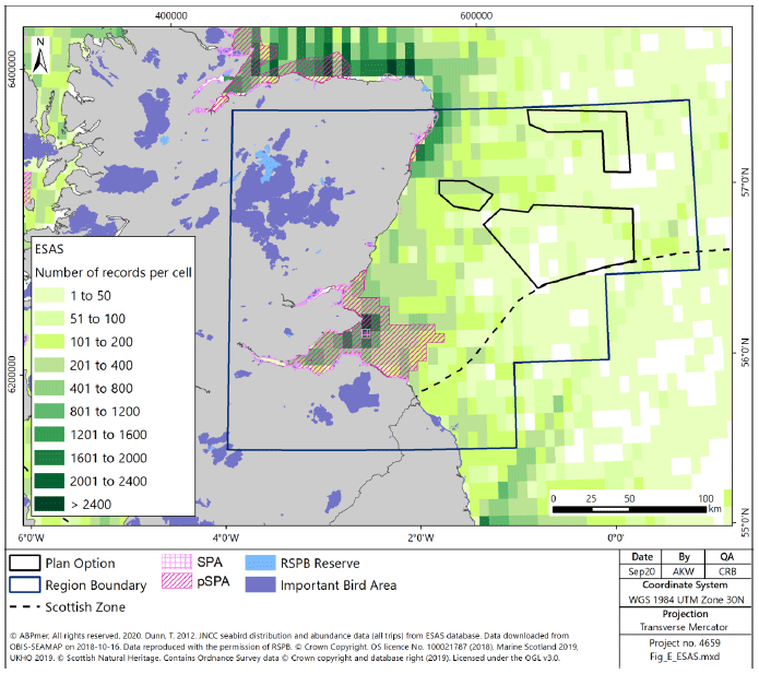
6.4.24 The majority of the seabird colonies within the East region are reviewed as part of the SPA management process, and in the majority of SPA the overall condition of the seabird or waterbird assemblages, with the exception of Forth Islands SPA and St Abbs Head to Fast Castle SPA, are assessed as favourable. However, at an individual species level a number of species are identified as being in unfavourable condition, and therefore management measures are in place to reduce pressure on these species. Species of importance in the East region include herring gull, shag, razorbill, kittiwake, Arctic tern, common tern, gannet, lesser black-backed gull, roseate tern, sandwich tern, puffin, fulmar, guillemot, shag and cormorant, in addition to a number of terrestrial or waterbird species. Wakefield et al[331] identify that the coastal seas throughout the East region are utilised by considerable numbers of seabirds. The areas of high usage identified in the multi-species analysis within the study correspond with the areas of high recording shown in Figure 225. Seabird usage of the seas to the east, further offshore, is assessed as being lower.
6.4.25 Figure 225 maps the total records of birds recorded in the marine environment in the East region. Whilst the data mapped has not been corrected for survey effort, it highlights areas of high importance, particularly in the outer Firth of Forth and associated with the seabird colonies on the coast to the north of Aberdeen, although recordings are high in coastal areas across the North East region. The Plan Options are largely in areas of lower recording, noting that this may be an artefact of lower survey effort. The exception to this is Plan Option E3, which is closer to the seabird colonies on the coast and therefore sits in seas of higher usage.
6.4.26 There are also a small number of coastal areas identified as either IBA or RSPB reserves in the East region, concentrated around the Firths of Forth and Tay, with some associated with seabird colonies on the coastline to the north and south of Aberdeen (Figure 225).
6.4.27 In addition to breeding populations within the East region, terrestrial and seabird bird species are known transit the area as migratory species, both during day and night time.
Cultural Heritage
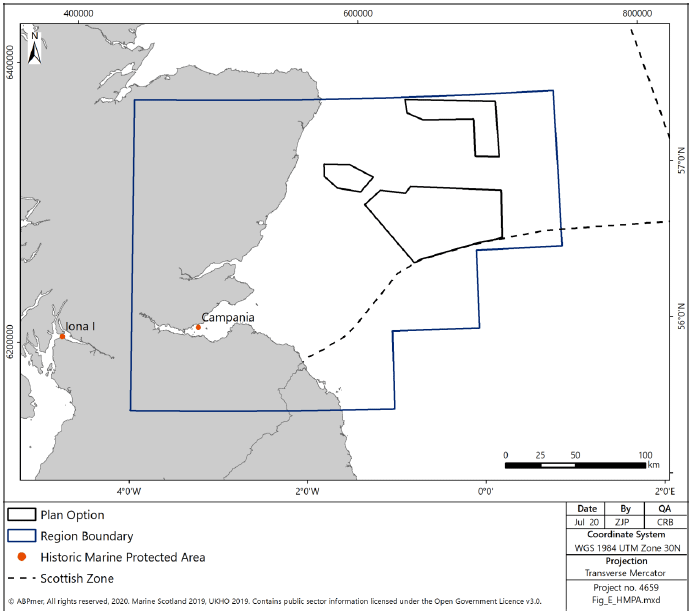
6.4.28 There is one Historic MPA (Campania Historic MPA), shown on Figure 226, designated in the East region, associated with a historic shipwreck in the Firth of Forth.
6.4.29 In addition to the Historic MPA, there are a number of scheduled monuments (included protected wrecks) within the East region. Those in the marine environment are concentrated around the coast and include a wide range of historically significant buildings, shipwrecks and structures. There are five shipwrecks designated for the protection of military remains, all located just outside the Firth of Forth. There is no overlap of protected sites and the Plan Options. There are additionally numerous other shipwrecks distributed throughout the East region, both within and outwith the Plan Options, although the majority are concentrated towards the coastline and within the Firth of Forth.
6.4.30 Within the East region, there are several areas within the have the potential to be examples of palaeolandscapes (landscapes which have become submerged following occupation by hominids), There is therefore potential that these areas may contain some culturally significant archaeological artefacts. These include areas that may overlap with the shallower Plan Options. Further assessment on a smaller scale would be required on a project by project basis.
Landscape / Seascape
6.4.31 Within the East region, as for the North East region landscapes and seascapes are considered to be less sensitive in comparison to the North and West regions. No NSAs have been designated within the region.
6.4.32 Candidate SLA which have been identified by the City of Edinburgh Council are over 100km from the nearest Plan Options.
6.4.33 When considering the sensitivity of the coastline Scott et al[332] identified that the coastline within the East region associated with mainland Scotland is of medium or low to medium sensitivity, due to the simple landform and general absence of focal features. The two areas identified by Scott et al. as medium sensitivity are associated with the Firths of Forth and Tay, both of which are over 80km from the nearest Plan Options. The Plan Options nearest to the coastline (E3 approximately 15km east of the coastline near Aberdeen) is located adjacent to coastline identified by Scott et al. as of low to medium sensitivity.
6.5 Planning Issues
6.5.1 There are eight local authorities with coastal interests within the East region:
- Aberdeenshire,
- Aberdeen City,
- Angus,
- Dundee City,
- Fife,
- City of Edinburgh,
- East Lothian, and
- Scottish Borders
6.5.2 Aberdeenshire Council in 2004[333] identified that the 250km coastline in the region offered unexplored potential for offshore wind, however there is no further guidance or consideration of offshore wind in documentation with the exception of considering siting for sub-stations.
6.5.3 The Aberdeen City Council, in its sustainable energy action plan[334], identifies the potential for offshore wind installations to support its objective to increase the share of alternative technologies producing energy to the consumers. It identifies the role that it can play in supporting the development of the supply chain within the city. As part of this Aberdeen City Council have been involved in the establishment of the Aberdeen Renewables Energy Group, which seeks to support companies developing capacity to support offshore wind.
6.5.4 Angus Council recognises its role in inputting to the application process for offshore wind farms, and notes its involvement in the development for the landfall and transmission of energy produced by offshore wind farms, both current and future[335]. Further, Angus Council has previously identified that it may request Marine Scotland to seek £5000 per megawatt installed capacity per annum for community benefits from offshore wind developers[336].
6.5.5 Following on from identification as a strategically important port location for marine renewable development Dundee City Council has sought to unlock opportunities in the Offshore Wind sector, through the creation of Energy Dundee and through development of training schemes to support the energy industry[337]. Planning was previously consented for the development of the port area to support renewables; however, construction was not undertaken and planning consent has now lapsed.
6.5.6 Fife Council recognises its role in the consenting process for offshore wind is limited to the supporting onshore infrastructure, for servicing facilities and for cable landfalls. It does, however, identify potential for impacts from offshore wind on the seascape and environment, alongside potential socio-economic benefits for the region[338].
6.5.7 City of Edinburgh Council has not directly addressed the potential for offshore wind in the sea adjacent to the city, and notes in its Sustainable Energy Development Plan only that there is limited potential for wind energy development within the city.
6.5.8 East Lothian Council recognises[339] the potential for future offshore wind development in the Firth of Forth, identifying that harbours within the Council’s area of responsibility have the potential to support the offshore wind installations. However, the LDP notes that the harbours should be prioritised for current uses (specifically including fishing). In addition, the LDP notes that there are currently consented sub-stations for cable landfalls and expects developers to reduce potential impacts by combining infrastructure, particularly identifying the potential for impacts on historic assets on or near the coasts[340]. Similar to the City of Edinburgh Council SLA identifies the potential for its coastline to be impacted by Wind Turbines in the Supplementary Planning Guidance[341], however these areas are approximately 60km from the nearest Plan Options.
6.5.9 The Scottish Borders Council does not consider offshore wind within its guidance on renewable energy, although it notes that the only restrictions on the placement of wind energy installations within its jurisdiction are the two NSA, both of which are inland and would not be impacted by offshore wind.